Article

Timing and Effect of the Hidden Thrust Fault on the Tight Reservoir in the Southeastern Sichuan Basin

1
School of Geoscience and Technology, Southwest Petroleum University, Chengdu 610500, China
2
Shunan Gas Field, PetroChina Southwest Oil & Gasfield Company, Luzhou 646000, China
*
Authors to whom correspondence should be addressed.
Minerals 2025, 15(11), 1209; https://doi.org/10.3390/min15111209
Submission received: 21 September 2025 / Revised: 25 October 2025 / Accepted: 31 October 2025 / Published: 18 November 2025
(This article belongs to the Section Mineral Exploration Methods and Applications)

Abstract

Determining the timing of hidden faults that terminate beneath the subsurface remains a significant challenge. For this contribution, seismic fault interpretation, fracture diagenesis analysis, and U-Pb dating of fracture cements are integrated to constrain the activity of hidden thrust faults in the southeastern Sichuan Basin. The results show that the EW- and NW-trending hidden thrust faults developed in the Permian, while the NE-trending faults have inherited later fault activity till the Cenozoic. The hidden thrust fault propagates upward from the top of the Upper Permian to the Lower Triassic strata. Fault inversion within the Permian is firstly identified by the thickness variation between the two fault walls. Core-based fracture diagenesis analysis indicates that multiple fractures and associated dissolution porosity developed within the tight matrix reservoir. In situ U-Pb dating of fracture cements yields ages of 247.4 ± 2 Ma and 234.8 ± 9.1 Ma, indicating that the hidden fault activity predates the Early Triassic. The absence of strata, evidence of structural uplift, and fault inversion collectively suggest that the first faulting in the eastern Sichuan Basin occurred at the end of the Middle Permian. The findings highlight that fracture–cave reservoir along the hidden thrust fault zone has been controlled by the coupling of the fracturing and karstification at the end of the Middle Permian, and is the key target for high gas production.

1. Introduction

Faults are fundamental crustal structures that provide essential insights into tectonic evolution and have broad applications in geological engineering [1,2,3]. Timing of fault activity is critical for deciphering fault mechanisms and evolution, and it plays an important role in enhancing permeability and porosity within tight reservoirs [3,4,5]. In sedimentary basin, fault activity is typically inferred from stratigraphic offset across the fault zone [4,5,6]. The timing is generally constrained by the youngest geological unit intersected by the fault and the oldest overlying undisturbed unit. The fault-related stratigraphic offset can be effectively identified through seismic interpretation, which has been widely applied to infer the fault activity in sedimentary basin. However, these methods are inadequate for hidden faults that do not extend to the surface. In addition, the limited resolution of seismic data constrains the detection of such hidden faults, particularly of the small-displacement fault in deep subsurface [6]. Furthermore, the predate fault activity may be overprinted by subsequent deformation. Therefore, dating multiple episodes of fault activity from seismic data alone remains a challenge in sedimentary basin.
Thermochronologic methods of K/Ar, 40Ar/39Ar, U/Pb, electron spin resonance, and fission track analyses have been widely applied to determine fault activity [7,8,9]. However, these methods are less suitable for the pre-Mesozoic faulting. Recently, in situ laser ablation U-Pb thermochronologic method has been used to date diagenetic and deformation history [10,11,12,13,14], providing high-resolution U-Pb ages that constrain the fault activity. Despite this progress, dating pre-Cenozoic faulting remains difficult due to the typically low U concentrations (<10 ppm) in fracture cements and challenges in obtaining representative subsurface samples. Consequently, available U-Pb ages for pre-Mesozoic faults remain sparse.
Large quantities of gas reserves have been found from the thrust fault zones in the eastern Sichuan Basin [15,16]. These faults play a key role in gas migration and accumulation. Seismic analyses of fault terminations suggest strong Cenozoic thrust fault activity in the intracontinental orogeny [17,18,19], whereas the initiation of fault activity remains uncertain due to multiple fault reactivations. Estimates vary, with prior studies placing the fault onset during the Indosinian–Yanshanian periods, middle Jurassic–late Cretaceous, or as late as the middle Cretaceous. Thermochronologic data from fission-track, zircon (U–Th)/He, and U-Pb dating from the thrust fault zone constrain the initial faulting to 100-70 Ma [20,21], 120–80 Ma [22], and 130–80 Ma [23], respectively. As a result, the influence of fracture network on pre-Jurassic carbonate reservoir has been largely overlooked, particularly given the multiple deformation events that have affected the basin.
This study integrates seismic interpretation of fault, fracture sequence analysis, and U-Pb ages of fracture cements from thrust fault zones in the southeastern Sichuan Basin. We aim to identify the first episode of fault activity and evaluate its effect on the Permian carbonate reservoir.

2. Geological Setting

The Sichuan Basin is an intracratonic basin in southwestern China (Figure 1a) that has experienced multiple stages of tectonic-sedimentary evolution [24]. It comprises a late Neoproterozoic intracratonic rift succession, a Cambrian–Middle Triassic marine carbonate succession, and a Late Triassic–Cenozoic continental siliciclastic succession. During the Middle Permian transgression, a carbonate platform covered most of the basin. Following the amalgamation of South China and North China at the end of the Middle Triassic, terrestrial siliciclastic rocks deposited in the basin. During the late Yanshanian (Cretaceous) and Himalayan movements, NE-trending fold-thrust belts developed throughout the eastern basin [17,18,19]. The southern portion of the thrust belt exhibits a broom-like structure, as observed in this study area (Figure 1b).
The Maokou Formation at the top of the Middle Permian is the main gas-bearing interval in the southeastern basin (Figure 1b), with a thickness ranging from 180 to 260 m and subdivided into four members [25]. The first member consists mainly of mudstone, the second and third are composed of grainstones interbedded with mudstones, and the fourth comprised alternating grainstone and mudstone. The ancient limestone has lost most of its primary porosity during prolonged diagenesis, resulting in very low porosity (<1.5%) and low permeability (<0.5 mD) [25,26,27]. The regional uplift at the end of the Middle Permian has resulted in partial erosion of the upper members in the southeastern basin [28]. Extensive karstification across the basin led to the development of karstic reservoirs at the top of the second and third members of the Maokou Formation. The secondary dissolution porosity became the main contributor to gas production and is commonly associated with high-energy microfacies and karstification processes [25,26,27]. Many wells have obtained high gas production from the karstic reservoirs.
After more than 70 years of exploration, most anticline-related gas resources have been exploited, shifting the exploration focus toward broad synclinal area. However, most Permian carbonate rocks are tight in the deeper synclines. Recently, several wells encountered high-yield reservoirs along thrust fault zones in the synclines. The fault activity is of importance in deciphering the gas migration and accumulation in the synclines [29]. Since these thrust faults were previously thought to have formed after the Cretaceous, their influence on reservoir development has been overlooked. Notably, no thermochronologic data have been used to constrain the hidden thrust faults in this region.
Figure 1. Tectonic location (a), geological map (b), and stratigraphic column of the Maokou Formation (c) in the southeastern Sichuan Basin (modified after reference [25,29]).
Minerals 15 01209 g001

3. Data and Methods

A 3D seismic dataset covers more than 5000 km2 in the southeastern Sichuan Basin. The survey’s bin spacing is 25 m × 25 m, and the main frequency range for the Permian is 20–30 Hz. The 3D migration-processed data provide sufficient resolution for major stratigraphic and structural interpretation [29]. While conventional seismic sections and attributes such as coherence and amplitude can effectively identify large thrust faults, small-scale thrust faults with vertical displacement less than 30 m are more difficult to resolve. Seismic analysis indicates that low signal-to-noise ratios of the fold-thrust belts in deep subsurface have hindered the fault imaging [29]. A seismic processing approach was employed to enhance seismic imaging of the deep hidden faults (see detailed methodology in References) [30]. This method is favorable for identifying the hidden thrust faults and clearer fault mapping.
Core data from 12 wells are investigated to evaluate the fractured reservoirs. The fracture occurrence, filling, and generations were investigated from the cores and thin sections. Porosity and permeability were determined using both core and well-logging data to characterize reservoir quality [26]. Two fracture calcite-cements samples from thrust fault zones were collected for in situ U–Pb dating. Rock chips were prepared from hand specimens, mounted on 2.5 cm epoxy disks, and polished for analysis. U-Pb dating was conducted using a Thermo Scientific quatraple iCap TQ ICP-MS system coupled with an ASI Resolution LR 193 nm ArF excimer laser ablation system at Sichuan Chuangyuan Weipu Analytical Technology Co., Ltd., Chengdu, China, following standard analytical procedures [13]. Instrument calibration employed NIST 612 glass standard to optimize parameters. Laser ablation conditions included a 50 μm spot size, 3 J/cm2 energy density, 10 Hz repetition rate, and 3 μm/s scan speed, with helium as a carrier gas (300 mL/min) and argon and nitrogen added to enhance sensitivity. Oxide yields were maintained below 1.5%, with optimized 238U sensitivity and 206Pb/238U ratios above 0.21. Calibration used in-house standards (AHX-1d, 236.9 ± 1.7 Ma) and Duff Brown Tank (64.0 ± 0.7 Ma) [31] to verify reliability and accuracy. Data reduction was performed using the Iolite package under the “U–Pb Geochronology” scheme, and the results were plotted using IsoplotR software (version 4.0) [14].
Combined geological, logging, and seismic data were analyzed to reconstruct fault activity and evaluate its effects on the carbonate reservoirs of the Maokou Formation in the southern Sichuan Basin (see workflow in Figure 2).

4. Results

4.1. Characteristics of the Thrust Fault

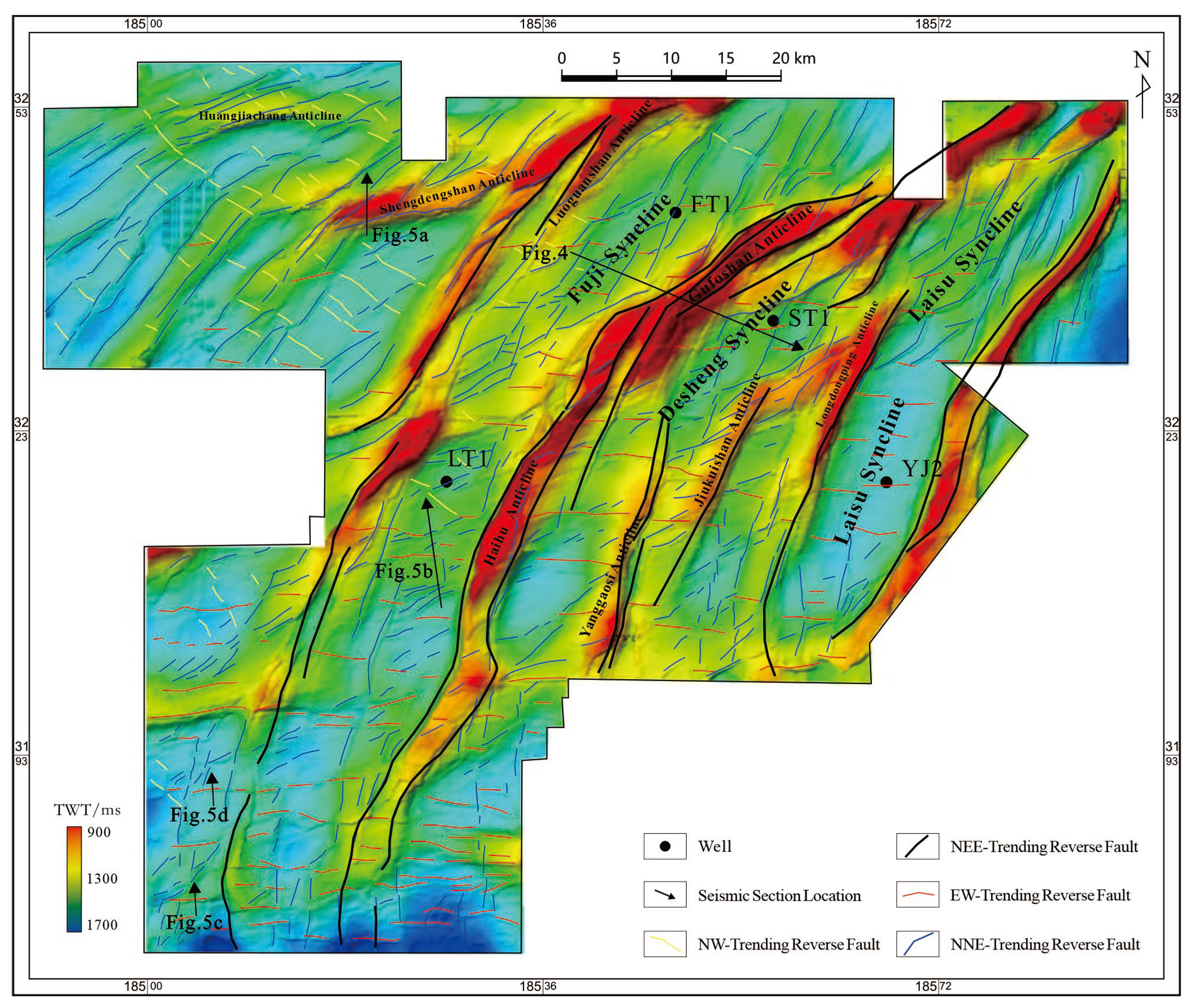
Seismic interpretation and mapping reveal three sets of thrust faults in the southeastern basin (Figure 3). The NE-, EW-, and NW-trending fault systems intersect to form a complex rhombohedral network.
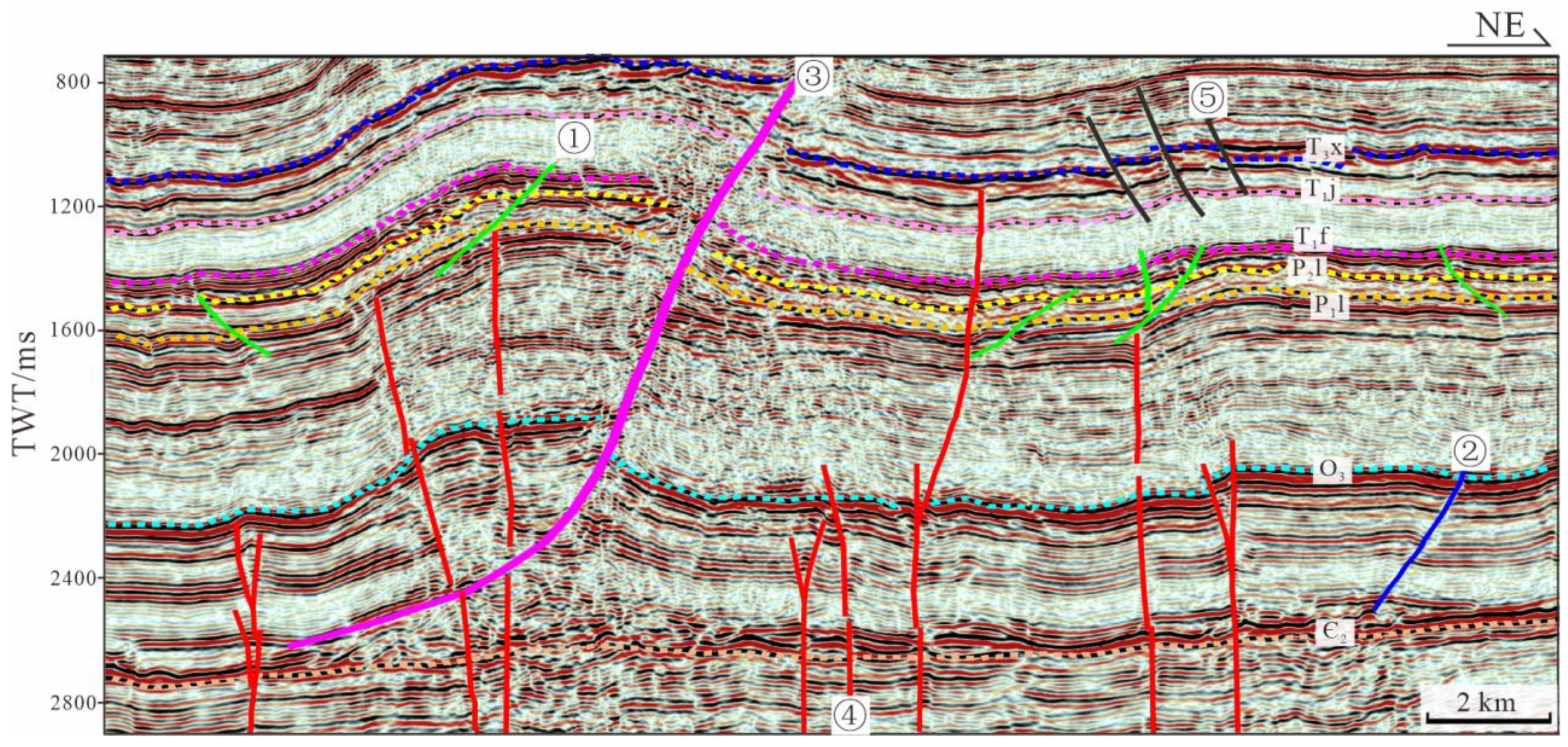
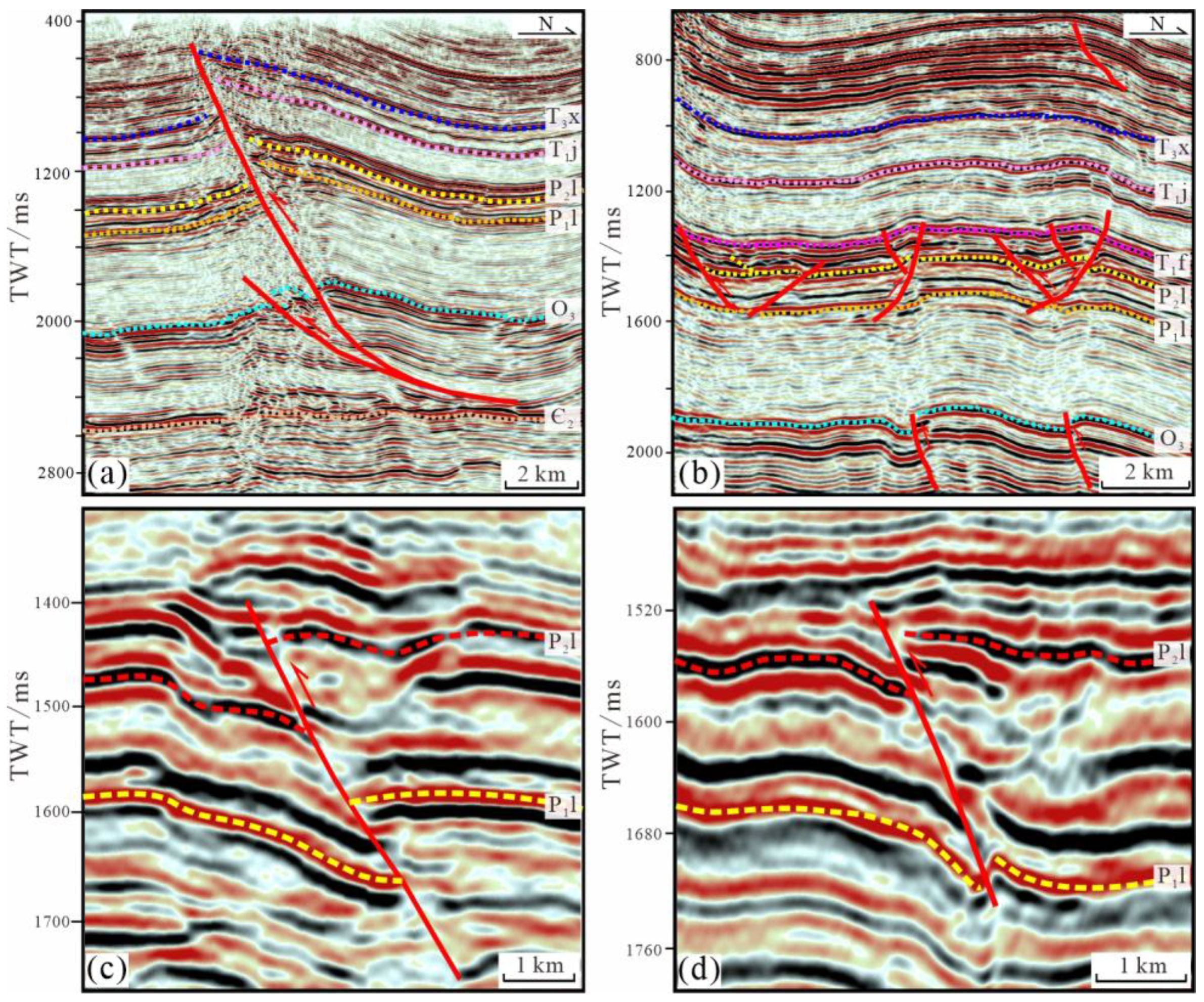
The NE-trending thrust fault system is the dominant structural feature, controlling the regional deformation architecture. Some faults trend NEE, aligning with the fold belts. These faults propagate outward from the northeast toward the southwest, forming multiple fold-thrust belts (Figure 3). The NE-trending faults are throughgoing, exhibiting the highest degree of deformation. The belt exhibits a thin-skinned style of deformation, detaching along the Middle Cambrian ductile layer (Figure 4). The fault displacements range from 100 m to 700 m and decrease progressively from north to south, as well as from the top strata to the Middle Cambrian (Figure 5a). Two detachment horizons occur within the Middle Cambrian and the Middle Triassic evaporite layers.
The EW- and NW-trending thrust faults are primarily hidden within the Permian strata. These two fault sets are mainly developed within the syncline and are crosscut and overprinted by later NE-trending faults (Figure 3). The EW-trending faults are most abundant in the southern area, where they decrease in scale northward and gradually change strike from the EW to NEE. They generally exhibit minor deformation, with displacements of 20–80 m and lengths of 5–20 km. Seismic sections show that most of these faults terminate near the top of the Permian (Figure 5b), with a few extending upward into the Lower Triassic and downward to the top of the Silurian. The NW-trending faults, mainly in the northwest of this study area, share similar features and relatively small displacements.
Overall, the EW- and NW-trending faults are offset by the NE-trending faults (Figure 3), suggesting that they are older structures. A few NW-trending faults intersect the NEE-trending faults within synclinal regions, making the relative timing difficult to determine. Seismic sections demonstrate that these hidden faults can extend upward to the base of the Lower Triassic and downward to the base of the Permian. Furthermore, variations in the thickness of the Maokou Formation between the hanging wall and footwall (Figure 5c,d) and the seismic facies differences indicate fault inversion. The hanging wall is locally thicker by over 100 m, implying that some faults were reactivated from the normal to the reverse displacement. This suggests that syn-sedimentary extensional faulting occurred during the deposition period of the Maokou Formation.

4.2. Fracture Diagenesis

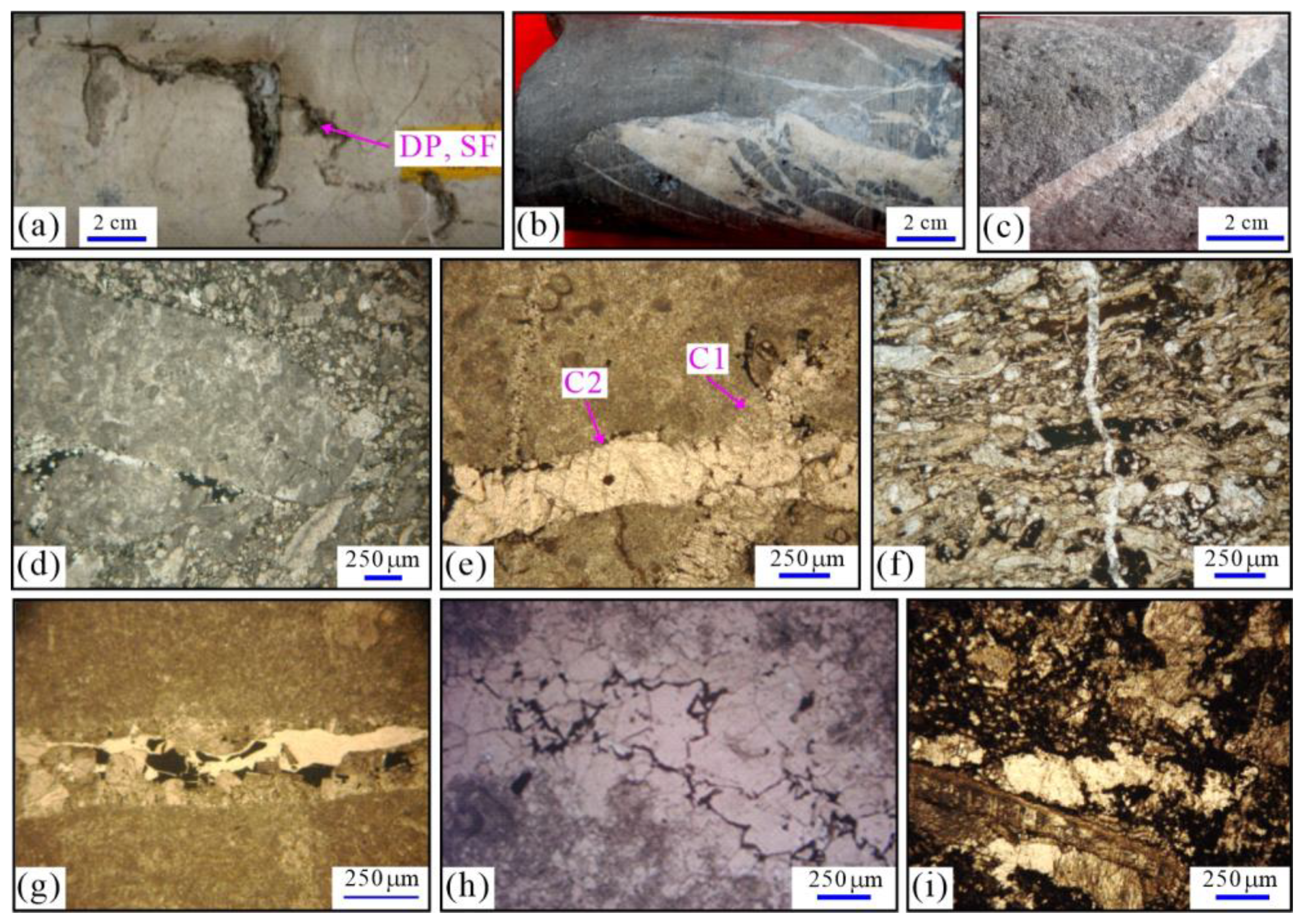
Microscopic and core observations indicate that numerous microfractures developed along the thrust fault zones. Vertical tectonic stylolites occur within the Permian limestones (Figure 6a). These stylolites are irregular and serrated and are locally enlarged by dissolution. High-angle fractures are concentrated within fault damage zones (Figure 6b,c), where calcite veins fill open fractures (Figure 6b). They may be associated with dolomite and quartz of hydrothermal origin. Within karstic cave, small fractures cut across brecciated infillings and mixed with the cave sediments (Figure 6d). In the fracture network, earlier fracture (C1 in Figure 6e) is intersected later on (C2 in Figure 6f), with later fracture typically exhibiting larger calcite crystals. Fracture frequency varies widely, from 1/m to over 10/m, generally following a power-law distribution that decreases outward from the fault core. Aperture of most fractures is narrow (<1 mm), although some open fractures reach apertures of up to 5 mm by multiple enlargement (Figure 6a,b,g).
Multiple mineral fillings are observed in the fractures. Calcite is the dominant cement, with minor argillaceous material, dolomite, and quartz. Typically, 2–3 generations of calcite cementation are present (Figure 6e). Hydrothermal dolomites occur in wide fractures (Figure 6g,h). Stylolite (Figure 6a) and some tectonic fractures (Figure 6d) are filled with argillaceous material. In the fracture–cave reservoirs at the top of the Middle Permian, mixed fillings of clay, fine-grained calcite, and coarse calcite veins are observed (Figure 6i). Asphalt occurs frequently in fracture and vug pores (Figure 6f,g,i). The unfilled fractures are usually small and narrow, crosscutting earlier cemented fractures and karstic porosity (Figure 6f). The predate fractures are typically completely cemented, whereas later fractures remain partly open.

4.3. Characteristics of the Fractured Reservoir

The Maokou Formation in this study area consists mainly of intraplatform shoal, intershoal sea, and open sea microfacies [25]. Primary porosity in the Permian limestone has been almost entirely occluded by diagenetic cementation (Figure 6). Cores, logging, and drilling data reveal well-developed karstic reservoirs in the Maokou Formation, particularly where dissolution porosity is concentrated along thrust fault zones (Figure 7).
Stylolite is often enlarged by dissolution, forming half-filled porosity (Figure 6a). In addition, some porosity is partially occupied by asphalt. The reservoir space within the tight limestone consists mainly of dissolution pore (diameter < 2 mm), vug (diameter between 2 and 100 mm), and cave (cave diameter > 100 mm, large cave diameter > 1000 mm). Karstic vugs and caves are abundant near the top of the Maokou Formation. Although most fractures are sealed by calcite cements (Figure 6b,c,e and Figure 7b), some retain residual porosity (Figure 6d,g), and late-stage dissolution along calcite veins is evident (Figure 7d). Multiple phases of fracture enlargement and dissolution have created secondary dissolution porosity along fractures and their peripheries (Figure 7a,e). Peripheral dissolution porosity generally exceeds fracture porosity.
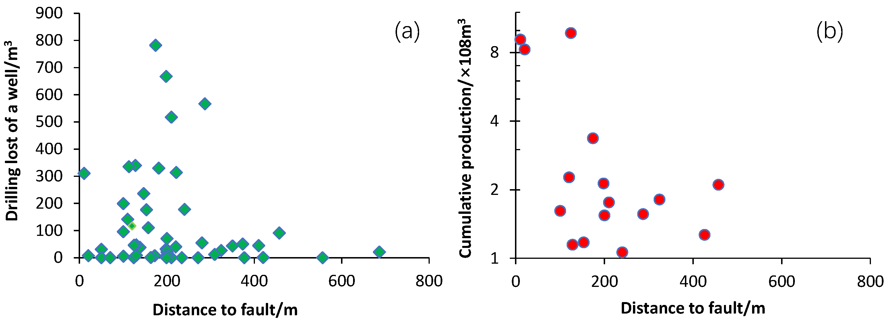
Drilling data confirm that wells with high gas production commonly intersect large fracture–cave reservoirs along thrust fault zones. Drilling losses and cumulative gas production show a clear correlation with proximity to fault damage zone (Figure 8). The width of these zones can exceed 500 m and is often associated with secondary fault splays. Reservoirs within these zones are confirmed by strong seismic amplitude anomalies consistent with mud losses and fracture–cavity signatures in well logs. Seismic, logging, and drilling evidence consistently indicate that large-scale fracture–cave reservoirs preferentially developed along fault zones and are responsible for high production.

4.4. U–Pb Ages of the Fracture Cements

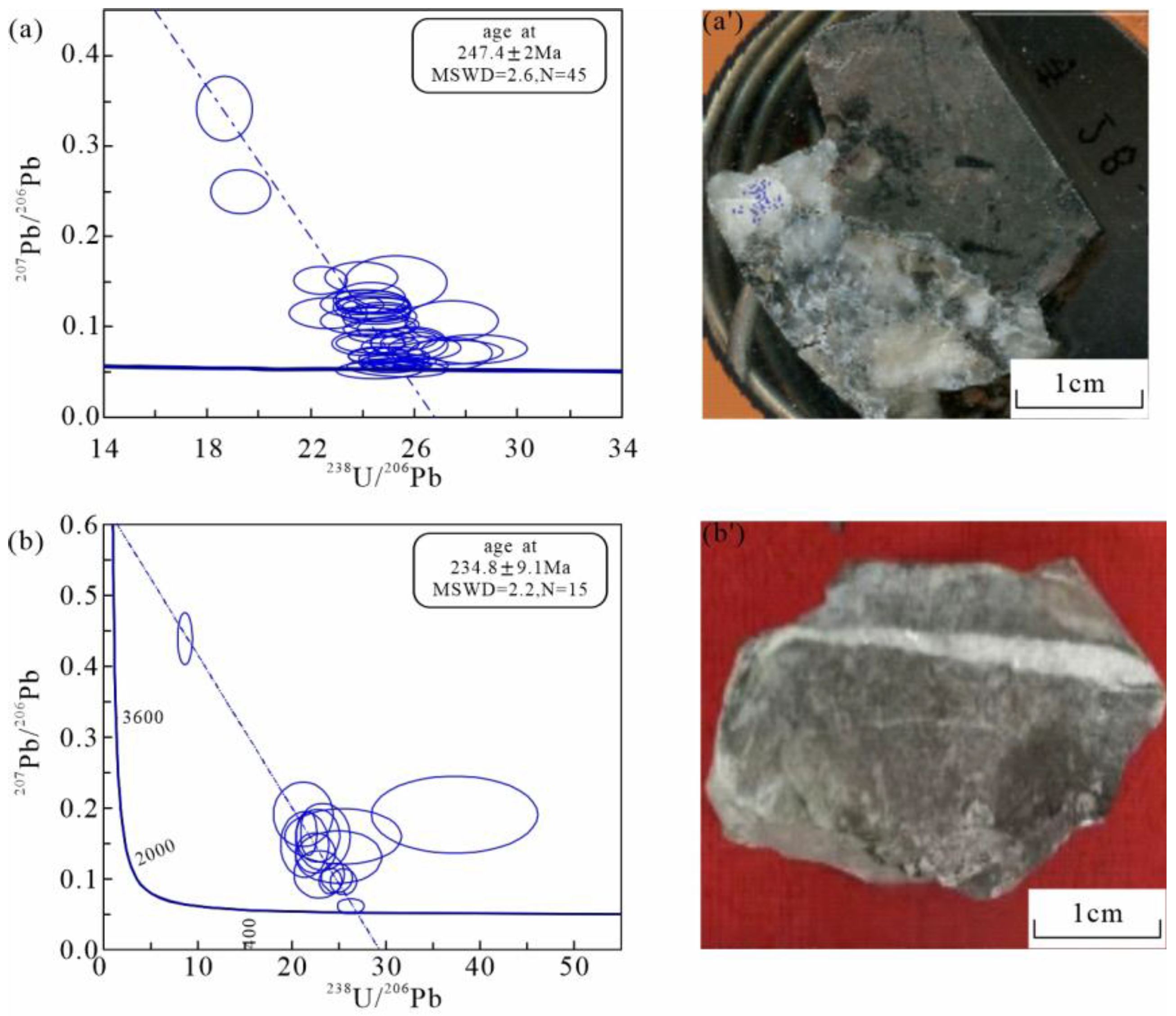
Fourth fracture-cement samples are collected from thrust fault zones, among which two yielded reliable U-Pb ages (Figure 9).
Sample S1 (from well S28) was taken from coarse calcite cement in a wide fracture (Figure 9a’). The U-Pb concordia diagram indicates an age of 247.4 ± 2 Ma (MSWD = 2.6) (Figure 9a). The 207Pb/235U–206Pb/238U ages are concordant and can be interpreted as the time of calcite cement crystallization. This U-Pb age corresponds well with the termination of thrust faulting near the top of the Permian.
Sample S2 (from well LT1) was collected from a vertical fracture (Figure 9b’). The sample yielded a relatively younger age of 234.8 ± 9.1 Ma (MSWD = 2.2) (Figure 9b). This likely represents calcite cementation during a subsequent burial environment, which is agreement with the Indosinian movement.
In situ U-Pb dating thus constrains two main episodes of calcite precipitation at ca. 247 Ma and 235 Ma, implying fault-related fluid activity and associated fracture diagenesis during the Early–Middle Triassic.

5. Discussion

5.1. Timing of Hidden Fault Activity

It has shown a discrepancy of the thermochronometric ages between this study and the ~130–70 Ma ages from previous studies [20,21,22,23]. The previous data from the outcrops of large fault zones can be correlated with the strong fault activity during the Late Mesozoic. The U-Pb dating samples of this study are collected from the hidden thrust fault in the southeastern basin that has little overprinting by the late fault activity. Regardless of some systemic error of the U-Pb dating, the 247 Ma and 235 Ma ages are much earlier than the U-Pb ages at ca. 105 Ma in the eastern Sichuan Basin [23]. The data of this study is consistent with the seismic data analysis, suggesting an earlier fault activity than the Cretaceous. The Yanshanian movement at ca. 130–70 Ma could also affect the large fault zone in this study area (Figure 4). Furthermore, the hidden fault that terminated during the Early Triassic is favorable for the thermochronological study. These older ages thus represent the first direct evidence for Permian–Triassic hidden thrust faulting in the southeastern Sichuan Basin.
In the eastern Sichuan Basin, previous seismic interpretations have placed thrust fault initiation anywhere from the Triassic to the Cretaceous [17,18,19]. However, relying solely on stratigraphic offsets is often unreliable for constraining hidden thrust fault activity. This study on seismic interpretations shows distinct variations in the thickness of the Maokou Formation between the hanging wall and footwall (Figure 5c,d), suggesting fault inversion. The syndepositional normal faulting has resulted in thicker deposition in the hanging wall, while subsequent compressional reactivation inverted these structures. Although the mechanism of the fault inversion needs further study, these suggest the fault activity initiated from the Middle Permian.
Regionally, the Emeishan Large Igneous Province (LIP) magmatism influenced the southeastern Sichuan Basin at the end of the Middle Permian [28]. The normal faulting (Figure 5c,d) and hydrothermal activity (including the formation of saddle dolomite; Figure 6b,g,h) likely resulted from the LIP activity [32]. Fault-related fluid flow during this period promoted diagenetic alteration and hydrothermal cementation within fracture networks, providing a plausible mechanism for early fault activity before the Late Triassic. In this context, the regional uplift and unconformity at the top of the Middle Permian may also have contributed to the onset of thrusting within the intracratonic basin. In addition, the Upper Permian is unconformable overlying on the Middle Permian [25,26,27]. These suggest that the thrust fault activity could initiate at the end of the Middle Permian. The thrust faults propagated upward in the Lower Triassic (Figure 5b) indicate a prolonged fault activity until the Early Triassic.
As the high-resolution in situ U-Pb dating of the fracture cement has been widely used to constrain the fault activity [33,34,35], the hidden fault activity can be constrained by the U-Pb dating on the fracture cement and fault seismic interpretation.

5.2. The Fault Effect on the Reservoir

Matrix porosity in the Maokou Formation is extremely low (<1.5%), and permeability is typically <0.5 mD [25,26,27]. Therefore, secondary porosity generated by fracturing and its related dissolution is critical for reservoir quality. The observed coincidence between fault activity and karstification at the end of the Middle Permian (Figure 6 and Figure 7) suggests that fault-controlled fracturing significantly enhanced reservoir properties.
In the short karstic time at the end of the Middle Permian, the fracture network in this study area is favorable for the dissolution porosity development in the karstic environment. The dissolution pores are abundant along the fracture zone and its periphery. Short-lived karstification events during regional uplift allowed meteoric water infiltration along fracture networks, creating extensive secondary porosity (Figure 10). Furthermore, hydrothermal fluids associated with Emeishan LIP activity may have further contributed to dissolution porosity along fracture networks [31]. In the burial environment, multiple dissolution porosity occurs along the fracture network. Although most fractures were later sealed by calcite and dolomite cement during burial, residual open fractures and partially dissolved cement zones provide the primary storage and migration pathways in the present-day reservoir. Later-stage fracturing likely reactivated these pathways.
This kind of fracture–cave reservoir has also been found in the Tarim Basin [36,37,38], which is correlated with the karstification along strike-slip fault zones. Statistical analysis of well data shows that high gas production wells are concentrated along the thrust fault zones (Figure 7b). Permeability in fractured reservoirs can exceed matrix permeability by more than an order of magnitude, and fracture–cavity systems display the highest production potential. Seismic interpretation confirms that large fracture–cave reservoirs align with fault damage zones, where fracture intensity and karstification are greatest. Thus, thrust fault zones serve as “sweet spots” for high-yield gas reservoirs due to their multi-phase fracturing and dissolution history.

6. Conclusions

(1)
Three sets of thrust faults are identified in the Permian of the southeastern Sichuan Basin based on seismic interpretation. The NE-trending faults exhibit inherited activity that extends to the surface, while the EW- and NW-trending hidden faults propagate upward from the Upper Permian into the Lower Triassic. Fault inversion is recognized through thickness variations between fault walls.
(2)
In situ U–Pb dating of fracture cements yields ages of 247.4 ± 2 Ma and 234.8 ± 9.1 Ma, indicating that hidden faulting predated the Early Triassic. Combined evidence from stratigraphic omission, structural uplift, and fault inversion suggests that thrust faulting initiated at the end of the Middle Permian.
(3)
Contemporaneous fracturing during the Late Permian was crucial for the development of fracture–cavity reservoirs at the top of the Middle Permian unconformity. These fracture–cavity systems along thrust fault damage zones constitute the principal targets for high gas production.
(4)
This study establishes a new temporal framework for deep hidden faults and provides key insights into the tectonic evolution and reservoir development of the southeastern Sichuan Basin.

Author Contributions

Conceptualization, H.L. and T.J.; methodology, W.T. and T.L.; software, H.T. and J.W.; investigation, T.L. and C.Q.; data curation, H.L. and H.T.; writing—original draft preparation, W.T. and H.T.; visualization, J.W. and M.D.; supervision, H.L. and T.J.; funding acquisition, H.L. All authors have read and agreed to the published version of the manuscript.

Funding

The National Natural Science Foundation of China (Grant No. U24B2019,4224100017) and the Science and Technology Cooperation Project of the CNPC-SWPU Innovation Alliance (Grant No. 2020CX010101, 2020CX010301).

Data Availability Statement

The data used to support the findings of this study are available from the corresponding author upon request.

Acknowledgments

The authors thank the editor and reviewer for their comments regarding manuscript improvement. We also thank Jiawei Liu, Zongyu Zhao and Hao Hu for their help in data.

Conflicts of Interest

Hui Long and Tian Liu are employees of Shunan Gas Field, PetroChina Southwest Oil & Gasfield Company. The authors declare that they have no known competing financial interests or personal relationships that could have appeared to influence the work reported in this paper.

References

  1. Caine, J.S.; Evans, J.P.; Forster, C.B. Fault zone architecture and permeability structure. Geology 1996, 24, 1025–1028. [Google Scholar] [CrossRef]
  2. Collettini, C.; Niemeijer, A.; Viti, C.; Marone, C. Fault zone fabric and fault weakness. Nature 2009, 462, 907–910. [Google Scholar] [CrossRef] [PubMed]
  3. Bense, V.F.; Gleeson, T.; Loveless, S.E.; Bour, O.; Scibek, J. Fault zone hydrogeology. Earth-Sci. Rev. 2013, 127, 171–192. [Google Scholar] [CrossRef]
  4. Fossen, H. Structural Geology; Cambridge University Press: Cambridge, UK, 2010. [Google Scholar]
  5. Bardot, K.; Lesueur, M.; Siade, A.J.; Lang, S.C.; McCallum, J.L. Structural uncertainty due to fault timing: A multimodel case study from the Perth Basin. Groundwater 2024, 63, 41–51. [Google Scholar] [CrossRef]
  6. Yang, H.J.; Wu, G.H.; Han, J.F.; Su, Z. Structural Analysis of Strike-Slip Faults in the Tarim Basin. Chin. J. Geol. 2020, 55, 1–16. (In Chinese) [Google Scholar] [CrossRef]
  7. Zuccari, C.; Mazzarini, F.; Tavarnelli, E.; Viola, G.; Aldega, L.; Moretto, V.; Xie, R.; Musumeci, G. How brittle detachments form and evolve through space and time. Earth Planet. Sci. Lett. 2024, 648, 119108. [Google Scholar] [CrossRef]
  8. Curzi, M.; Viola, G.; Zuccari, C.; Aldega, L.; Billi, A.; Van Der Lelij, R.; Kylander-Clark, A.; Vignaroli, G. Tectonic evolution of the Eastern Southern Alps (Italy): A reappraisal from new structural data and geochronological constraints. Tectonics 2024, 43, 008013. [Google Scholar] [CrossRef]
  9. Del Sole, L.; Viola, G.; Aldega, L.; Moretto, V.; Curzi, M.; Xie, R.; Cantelli, L.; Vignaroli, G. High-resolution investigations of fault architecture in space and time. Sci. Rep. 2025, 15, 2258. [Google Scholar] [CrossRef]
  10. Roberts, N.M.W.; Walker, R.J. U-Pb geochronology of calcite-mineralized faults: Absolute timing of rift-related fault events on the northeast Atlantic margin. Geology 2016, 44, 531–534. [Google Scholar] [CrossRef]
  11. Godeau, N.; Deschamps, P.; Guihou, A.; Leonide, P.; Tendil, A.; Gerdes, A.; Hamelin, B.; Girard, J.P. U-Pb dating of calcite cement and diagenetic history in microporous carbonate reservoirs: Case of the Urgonian Limestone, France. Geology 2018, 46, 247–250. [Google Scholar] [CrossRef]
  12. Parrish, R.R.; Parrish, C.M.; Lasalle, S. Vein calcite dating reveals Pyrenean orogeny as cause of Paleogene deformation in southern England. J. Geol. Soc. 2018, 175, 425–442. [Google Scholar] [CrossRef]
  13. Nuriel, P.; Wotzlaw, J.F.; Ovtcharova, M.; Vaks, A.; Stremtan, C.; Šala, M.; Roberts, N.M.W.; Kylander-Clark, A.R.C. The use of ASH-15 flowstone as a matrix-matched reference material for laser-ablation U Pb geochronology of calcite. Geochronology 2021, 3, 35–47. [Google Scholar] [CrossRef]
  14. Yang, P.; Wu, G.H.; Nurield, P.; Nguyen, A.D.; Chen, Y.Q.; Yang, S.; Feng, Y.X.; Ren, Z.L.; Zhao, J.X. In situ LA-ICPMS U-Pb dating and geochemical characterization of fault-zone calcite in the central Tarim Basin, northwest China: Implications for fluid circulation and fault reactivation. Chem. Geol. 2021, 568, 120125. [Google Scholar] [CrossRef]
  15. Xu, M.L.; Yang, Y.B.; Sun, C.Y.; Qiu, G.E.; Chen, L.; Jing, L. Geophysical characterisation and oil–gas resource analysis of the southern Huaying Mountain Fault Zone, Sichuan Basin, China. Minerals 2023, 13, 270. [Google Scholar] [CrossRef]
  16. Li, Z.; Zhang, Z.P.; Li, S.J.; Xia, W.Q. Characteristics of fault systems and their reservoir control in the Qijiang area of southeastern Sichuan Basin. Nat. Gas Geosci. 2024, 35, 1999–2011. [Google Scholar]
  17. Yan, D.P.; Wang, X.W.; Liu, Y.Y. Analysis of fold style and its formation mechanism in the area of boundary among Sichuan, Hubei and Hunan. Geoscience 2000, 14, 17–43. [Google Scholar]
  18. Li, C.X.; He, D.F.; Lu, G.; Wen, K.; Simon, A.; Sun, Y.P. Multiple thrust detachments and their implications for hydrocarbon accumulation in the northeastern Sichuan Basin, southwestern China. AAPG Bull. 2021, 105, 357–390. [Google Scholar] [CrossRef]
  19. Yang, G.; Chen, Z.X.; Wang, X.B. Double wedged-shaped structures of the Mingyuexia anticline in eastern Sichuan thrust belt, South China. Geolo. Rev. 2021, 67, 901–916, (In Chinese with English abstract). [Google Scholar]
  20. Shen, C.B.; Mei, L.F.; Xu, S.H. Fission track dating of Mesozoic sandstones and its tectonic significance in the Eastern Sichuan Basin, China. Radiat. Meas. 2009, 44, 945–949. [Google Scholar] [CrossRef]
  21. Deng, B.; Liu, S.G.; Li, Z.W.; Jansa, L.F.; Liu, S.; Wang, G.Z.; Sun, W. Differential exhumation at eastern margin of the Tibetan Plateau, from apatite fission-track thermochronology. Tectonophysics 2013, 591, 98–115. [Google Scholar] [CrossRef]
  22. Tian, Y.T.; Qiu, N.S.; Kohn, B.P.; Zhu, C.Q.; Hu, S.B.; Gleadow, A.J.W.; McInnes, B.I.A. Detrital zircon (U—Th)/He thermochronometry of the Mesozoic Daba Shan Foreland Basin, central China: Evidence for timing of post-orogenic denudation. Tectonophysics 2012, 570–571, 65–77. [Google Scholar] [CrossRef]
  23. Cao, Y.; Xu, Q.; Zheng, J.F.; Tan, X.C.; Li, M.L.; Stephen, K.; Li, L.; Qiu, Y.C.; Deng, W. Two stages of Late Cretaceous to Neogene deformation of the Huayingshan tectonic belt, eastern Sichuan Basin, SW China. J. Asian Earth Sci. 2023, 255, 105779. [Google Scholar] [CrossRef]
  24. Liu, S.G.; Yang, Y.; Deng, B.; Zhong, Y.; Wen, L.; Sun, W.; Li, Z.W.; Jansa, L.; Li, J.X.; Song, J.M.; et al. Tectonic evolution of the Sichuan Basin, Southwest China. Earth-Sci. Rev. 2021, 213, 103470. [Google Scholar] [CrossRef]
  25. Xiao, D.; Tan, X.C.; Xi, A.H.; Liu, H.; Shan, S.J.; Xia, J.W.; Cheng, Y.; Lian, C.B. An inland facies-controlled eogenetic karst of the carbonate reservoir in the Middle Permian Maokou Formation, southern Sichuan Basin, SW China. Mar. Pet. Geol. 2016, 72, 218–233. [Google Scholar] [CrossRef]
  26. Huang, S.P.; Jiang, Q.C.; Feng, Q.F.; Wu, Y.; Lu, W.H.; Su, W.; Chen, X.Y.; Ren, M.Y.; Peng, H. Type and distribution of Mid-Permian Maokou Formation karst reservoirs in southern Sichuan Basin, SW China. Pet. Explor. Dev. 2019, 46, 293–300. [Google Scholar] [CrossRef]
  27. Zhu, D.C.; Zou, H.Y.; Yang, M.L.; Li, T.; Li, T.; Li, H.P.; Xu, L.; Wen, L.; Zhou, G. The Middle Permian Maokou reservoir (southern Sichuan Basin, China): Controls on karst development and distribution. J. Pet. Sci. Eng. 2021, 204, 108686. [Google Scholar] [CrossRef]
  28. Huang, H.; Huyskens, M.H.; Yin, Q.Z.; Cawood, P.A.; Hou, M.C.; Yang, J.H.; Xiong, F.H.; Du, Y.S.; Yang, C.C. Eruptive tempo of Emeishan large igneous province, southwestern China and northern Vietnam: Relations to biotic crises and paleoclimate changes around the Guadalupian-Lopingian boundary. Geology 2022, 50, 1083–1087. [Google Scholar] [CrossRef]
  29. Liu, J.W.; Wu, G.H.; Li, H.; Zhang, W.J.; Zheng, M.J.; Long, L.; Li, C.H.; Deng, M. Identification of strike-slip faults and their control on the Permian Maokou gas reservoir in the southern Sichuan Basin (SW China): Fault intersections as hydrocarbon enrichment zones. Energies 2024, 17, 246438. [Google Scholar] [CrossRef]
  30. Li, H.; Liu, J.W.; Zheng, M.J.; Li, S.Y.; Long, H.; Li, C.H.; Huang, X.R. The seismic identification of small strike-slip faults in the deep Sichuan basin (SW China). Processes 2024, 12, 071508. [Google Scholar] [CrossRef]
  31. Hill, C.A.; Polyak, V.J.; Asmerom, Y.; Provencio, P.P. Constraints on a Late Cretaceous uplift, denudation, and incision of the Grand Canyon region, southwestern Colorado Plateau, USA, from U-Pb dating of lacustrine limestone. Tectonics 2016, 35, 896–906. [Google Scholar] [CrossRef]
  32. Li, T.; Zhu, D.C.; Yang, M.L.; Zhang, X.H.; Li, P.P.; Lu, C.J.; Zou, H.Y. Early-stage marine dolomite altered by hydro-thermal fluids in the Middle Permian Maokou Formation in the eastern Sichuan Basin, Southern China. Mar. Pet. Geol. 2021, 134, 105367. [Google Scholar] [CrossRef]
  33. Salih, N.; Mansurbeg, H.; Kolo, K.; Gerdes, A.; Préat, A. In situ U-Pb dating of hydrothermal diagenesis in tectonically controlled fracturing in the Upper Cretaceous Bekhme Formation, Kurdistan Region-Iraq. Int. Geol. Rev. 2020, 62, 2261–2279. [Google Scholar] [CrossRef]
  34. Palacios-García, N.B.; Fitz-Díaz, E.; Stockli, L.D.; Stockli, D.F. U–Pb calcite dating of brittle deformation in Permian carbonates within the Chicomuselo fold and thrust belt, SE Mexico. J. Struct. Geol. 2023, 171, 104863. [Google Scholar] [CrossRef]
  35. Ma, B.S.; Wu, G.H.; Zhang, Y.T.; Scarselli, N.; Yang, B.; Jiang, Y.K.; Yao, J.; Zhao, X.X.; Yang, M.C.; Wang, J. New constraints from in-situ U-Pb ages and fluid inclusions of calcite cement and structural analysis on multiple stages of strike-slip fault activities in the northern Tarim Basin, NW China. J. Asian Earth Sci. 2024, 273, 106246. [Google Scholar] [CrossRef]
  36. Wang, R.J.; Yang, J.P.; Chang, L.J.; Zhang, Y.T.; Sun, C.; Wan, X.G.; Wu, G.H.; Bai, B.C. 3D modeling of fracture-cave reservoir from a strike-slip fault-controlled carbonate oilfield in northwestern China. Energies 2022, 15, 176415. [Google Scholar] [CrossRef]
  37. Wang, S.L.; Chen, L.X.; Su, Z.; Dong, H.Q.; Ma, B.S.; Zhao, B.; Lu, Z.D.; Zhang, M. Differential characteristics of conjugate strike-slip faults and their controls on fracture-cave reservoirs in the Halahatang area of the northern Tarim Basin, NW China. Minerals 2024, 14, 070688. [Google Scholar] [CrossRef]
  38. Wang, J.; Wang, X.T.; Cao, Y.C.; Hao, F.; Pang, Y.H.; Yun, L.; Yang, H.J.; Xie, M.F. Characteristics and origin of the ultradeep Ordovician fault-karst reservoirs: An example from the Shunbei-Yuejin area, Tarim Basin. AAPG Bull. 2024, 108, 1231–1260. [Google Scholar] [CrossRef]
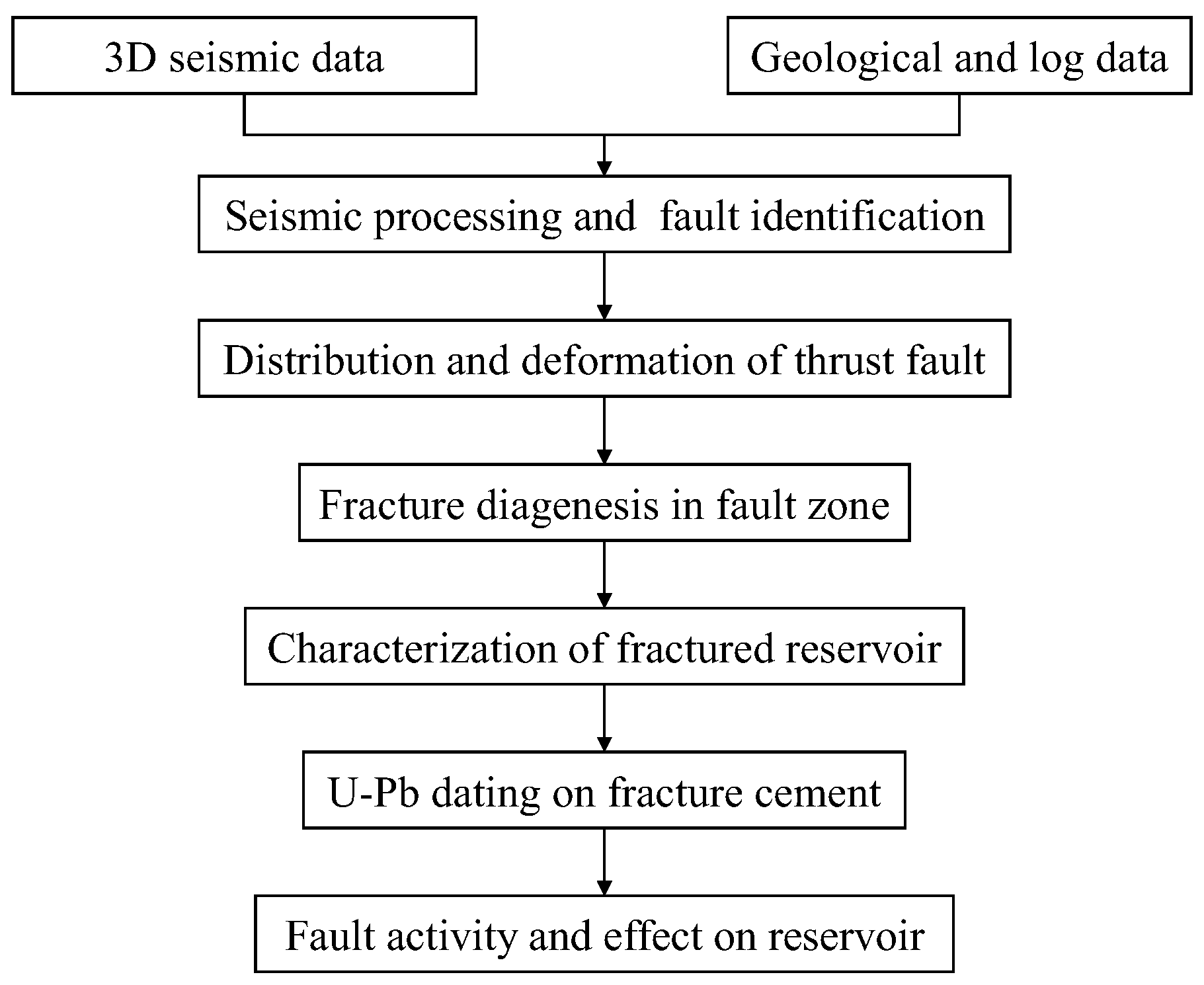
Figure 2. The workflow of the hidden thrust fault analysis in the southeastern Sichuan Basin.
Minerals 15 01209 g002
Figure 3. The thrust fault system of the Permian in the southeastern Sichuan Basin (the base map showing the structural topography at the top of the Middle Permian).
Minerals 15 01209 g003
Figure 4. The typical seismic section showing the fault system in the southeastern Sichuan Basin (①: the green line shows the hidden thrust fault in the Permian; ②: the blue line shows the hidden thrust fault in the Cambrian; ③: the magenta line shows the thrust fault along the folding belts; ④: the red line shows the deep strike-slip fault; ⑤: the black line shows the thrust fault in the Triassic).
Minerals 15 01209 g004
Figure 5. The typical seismic sections show the thrust faults. (a) thrust faults with the Middle Cambrian detachment; (b) hidden thrust faults in the Permian; (c) the strata thickness change between the two walls; (d) the thicker hanging wall indicating fault inversion. TWT: two-way time of the seismic wave; T3x: Xujiahe Formation of the Upper Triassic; T1j: Jialingjiang Formation of the Lower Triassic; T1f: Feixianguan Formation of the Lower Triassic; P2l: Changxing Formation of the Permian; O3w: the Upper Ordovician; Є2: Middle Cambrian; the red lines show the thrust fault traces; the red arrows show the movement direction of faults.
Minerals 15 01209 g005
Figure 6. The typical petrographic photos showing multiple fractures in the Maokou Formation (a): well W28, 1530.5 m, stylolite and dissolution porosity filled by asphalt; (b): well Z1, 2425.5 m, hydrothermal calcite vein in the expansion fracture; (c): well Y1, high-angle fracture filled by calcite cement; (d): well L40, fracture in the breccia of the cave; (e): well w17, two generations cementation in the intersected fractures; (f): well S13, open fracture intersected the asphalt in the dissolution vug; (g): well L40, 2215.85 m, multiple fillings by calcite and hydrothermal dolomite in the dissolved fracture; (h): well W17, 1670.5 m, fracture filled by dolomite cement and intercrystalline porosity; (i): well S13, the argillaceous, calcite, and asphalt fillings in the fracture–cave reservoir.
Minerals 15 01209 g006
Figure 7. The dissolution porosity along the fracture network in the Maokou Formation (ad): cores; (a): well Z1, 2374 m, unfilled dissolution vugs along the fracture and its periphery; (b): well B30, 3139 m, enlarged and calcite filled fractures, dense dissolution vugs in the periphery; (c): well W17, fractured cave filled by breccia and cement; (d): well B35, late dissolution porosity along the calcite cement in the fracture; (e): well Y2, FMI image showing the high-angle fracture and dissolution vug along the fracture; (f): well Y2, 2989.42–2990.98m, core sample showing the high-angle fracture and dissolution vug along the fracture. DV: dissolution vug; FP: fracture porosity; FF: filled fracture; FC: fracture–cave.
Minerals 15 01209 g007
Figure 8. The drilling loss (a) and cumulative gas production (b) from the wells vs. distance to fault in the Maokou Formation (the data from the production wells in the thrust fault zones).
Minerals 15 01209 g008
Figure 9. In situ U-Pb ages and sample photos of the fractures in the Permian thrust fault zones. (a) Tera–Wasserburg concordia plot for sample S1 (Well S28, 247.4 ± 2 Ma); (a′) hand specimen showing coarse calcite vein in a wide fracture; (b) Tera–Wasserburg concordia plot for sample S2 (Well LT1, 234.8 ± 9.1 Ma); (b′) hand specimen showing vertical fracture filled with calcite cement. U-Pb data are plotted with 2σ error ellipses. The dotted lines that intercept the concordia plot represent a mixing line between a common-lead (top intercept) and radiogenic-lead (lower intercept) end-member. All lower intercepts ages in Tera–Wasserburg diagrams are with low MSWD and calculated with Isoplot program.
Minerals 15 01209 g009
Figure 10. The evolution model of the Permian fracture–cave reservoir in the southeastern Sichuan Basin ((a): the Emeishan LIP-related syndepositional normal faulting during the Maokou deposition period; (b): the uplift, denudation, and thrust fault activity at the end of the Middle Permian; (c): the vug–cave reservoir development with the karstification and dissolution; (d): the hydrothermal dissolution and burial cementation during the Early–Middle Triassic).
Minerals 15 01209 g010
Disclaimer/Publisher’s Note: The statements, opinions and data contained in all publications are solely those of the individual author(s) and contributor(s) and not of MDPI and/or the editor(s). MDPI and/or the editor(s) disclaim responsibility for any injury to people or property resulting from any ideas, methods, instructions or products referred to in the content.