1. Introduction
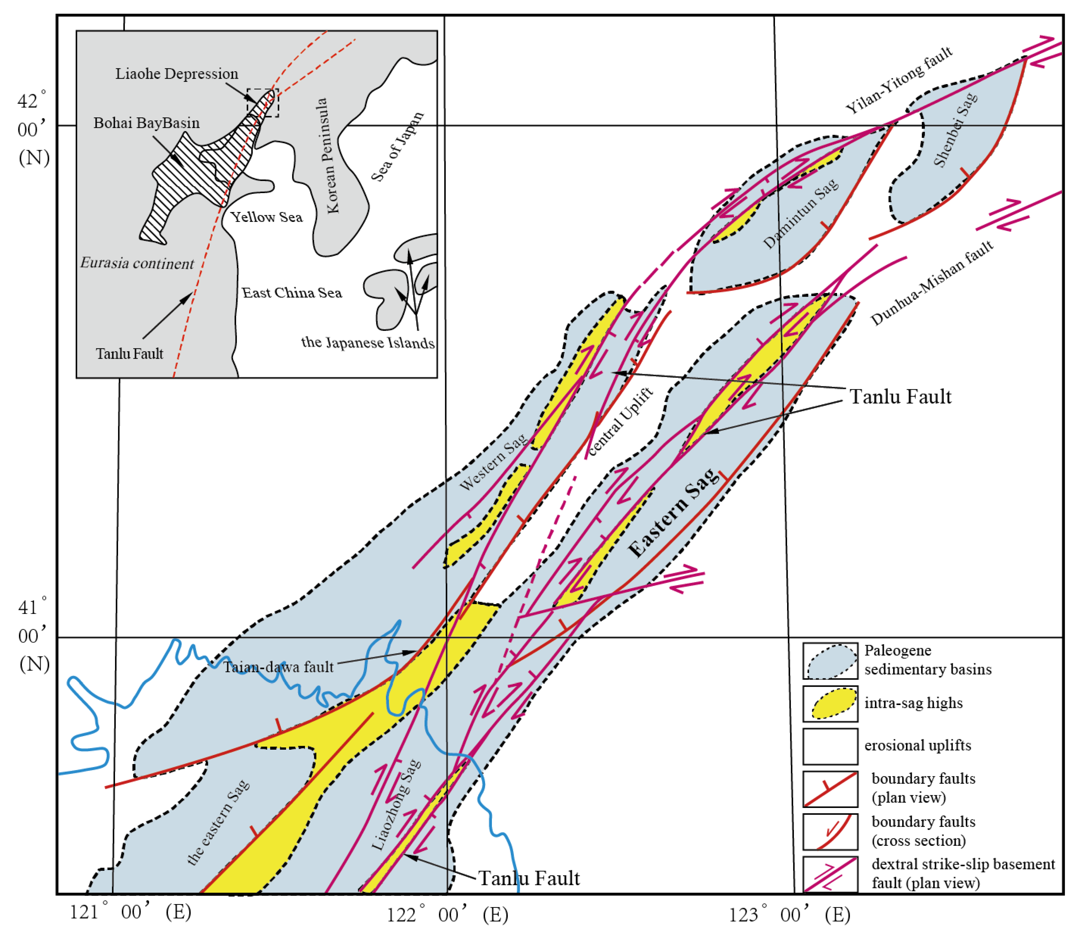
The Eastern Sag of the Liaohe Depression (hereafter referred to as the Eastern Sag) is located in the northeastern part of the Bohai Bay Basin, one of the most important Cenozoic petroliferous basins in eastern China. The Bohai Bay Basin itself formed within the eastern North China Craton, which has experienced a long and complex tectonic process characterized by the transition from compressional to extensional regimes since the late Mesozoic. This geodynamic evolution is largely influenced by the regional activity of the Tan–Lu Fault Zone, subduction of the Pacific Plate, and subsequent lithospheric thinning and strike-slip reactivation of inherited crustal structures. Similar to other extensional strike-slip basins in eastern Asia, especially those in northeastern China and the Japan Sea region, the Bohai Bay Basin records multiple phases of extension, strike-slip deformation, and thermal subsidence throughout the Cenozoic [
1,
2,
3,
4]. Against this regional tectonic background, the Liaohe Depression developed as one of the major structural units of the Bohai Bay Basin, consisting of the Western, Central, and Eastern sags.
The Eastern Sag is an elongated NE-trending depression with a length of 130 km and a width of 25 km, structurally characterized by a dustpan-shaped geometry that is steeply faulted on the east and gently dipping on the west. Numerous faults are well developed within the sag, including the Tianzhuangtai, Youdong, Jiazhangsi, Yingkou–Tong’erpu, Jiedong, Yujiafang, Cidong, and Cixi faults (
Figure 1). From south to north, four major fault-controlled sub-sags can be identified: the Huangjin Belt Sag, Jiazhuangsi Sag, Erjiegu Sag, and the southern Gaizhoutan Sag [
5]. This area has been an important target for hydrocarbon exploration because of its abundant source rocks and complex trap configurations.
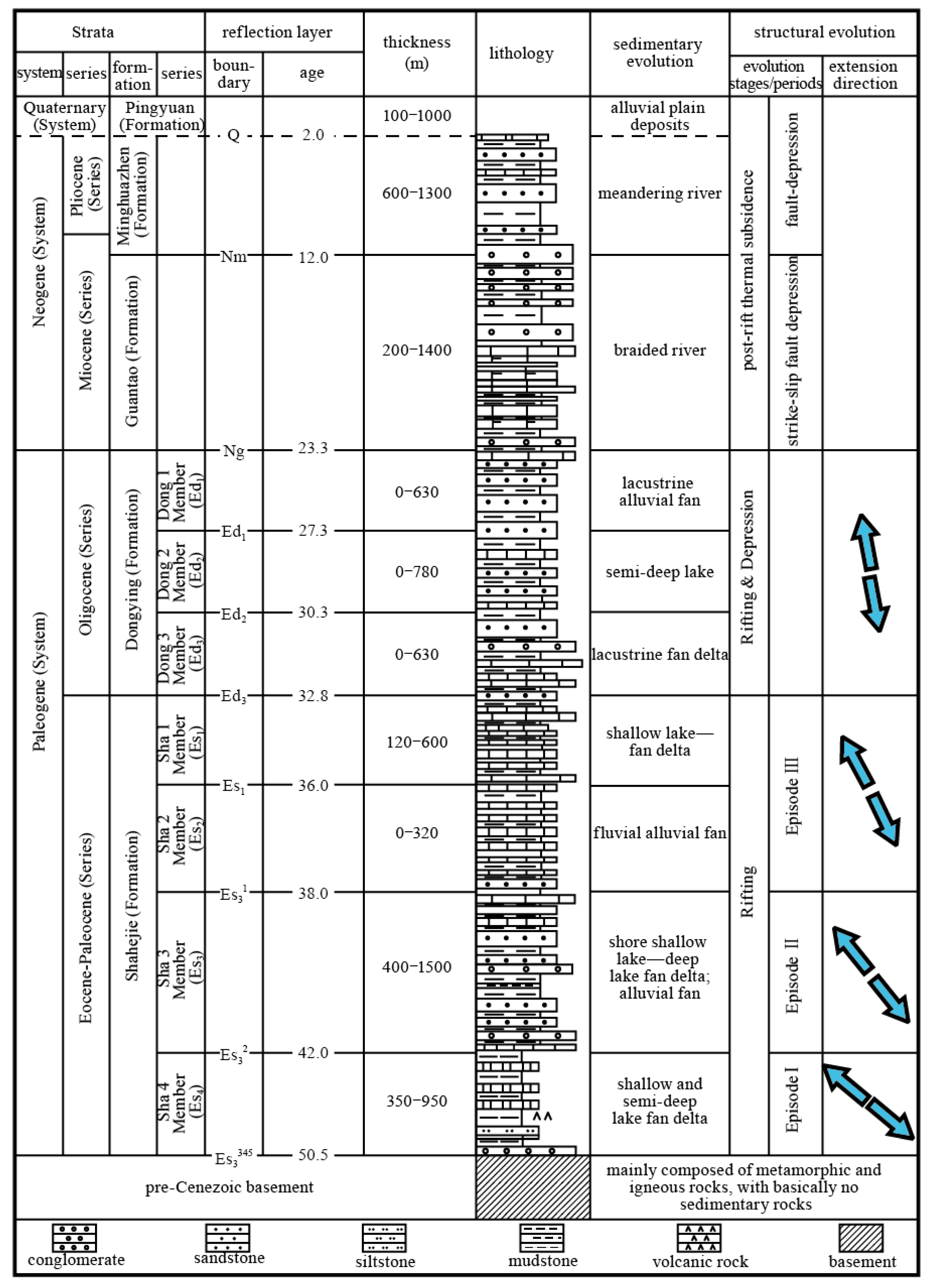
The discovered oil and gas reserves in the Eastern Sag are primarily concentrated in the middle-shallow reservoirs, such as the Dongying Formation, the First Member of the Shahejie Formation (Es
1), and the Upper Submember of Es
3 (the Third Member of Shahejie Formation). In contrast, deeper reservoirs, such as the Middle and Lower Submembers of Es
3, have become new key targets for current hydrocarbon exploration (
Figure 2). It is suggested that the remaining hydrocarbon resources mainly exist in buried hill reservoirs and structural-lithologic composite traps. However, large-scale discoveries have yet to be found.
Researchers have conducted numerous studies on the structural evolution, sedimentary systems, and the identification of source and reservoir rocks in the central and southern segments of the Eastern Sag. These studies indicate that the sag experienced multiple stages of Cenozoic deformation, including early extensional faulting followed by strike-slip reactivation related to the Tan–Lu Fault Zone, and that variations in fault–caprock configuration and syn-tectonic sedimentation reflect episodic subsidence across the region [
6,
7,
8,
9,
10]. However, limited availability of deep seismic data has hindered comprehensive understanding of the spatial heterogeneity and overall evolutionary framework of the sag. In particular, the detailed relationships between regional tectonic stress fields, fault geometries, and microstructural deformation within the strata remain poorly constrained.
Recent advances in deep seismic acquisition and analog modeling enable refined interpretations of basin-scale deformation. In this study, newly acquired deep seismic reflection profiles were analyzed to characterize representative structural zones along the strike of the sag. Complementary sandbox modeling experiments were conducted to reconstruct the prototype basin and validate the kinematic processes inferred from seismic data. Furthermore, microstructural analyses of thin sections from fault-related cores were integrated with the seismic and modeling results to provide a multi-scale view of deformation. This integrated approach allows reconstruction of the Cenozoic tectonic evolution and identification of the controlling mechanisms responsible for the present-day structural configuration of the Eastern Sag.
In the past years, particular attention has been given to transtensional and transpressional faulting, which exerted a fundamental influence on basin segmentation and fault linkage. Although previous studies have mentioned the occurrence of strike-slip reactivation, this work provides the first detailed synthesis of its spatial distribution and dynamic significance based on combined geophysical, experimental, and petrographic evidence. The findings not only improve the understanding of fault kinematics and basin evolution in the Eastern Sag, but also offer valuable insights for predicting deep hydrocarbon accumulation and guiding future exploration in the Bohai Bay Basin.
2. Structural Interpretation
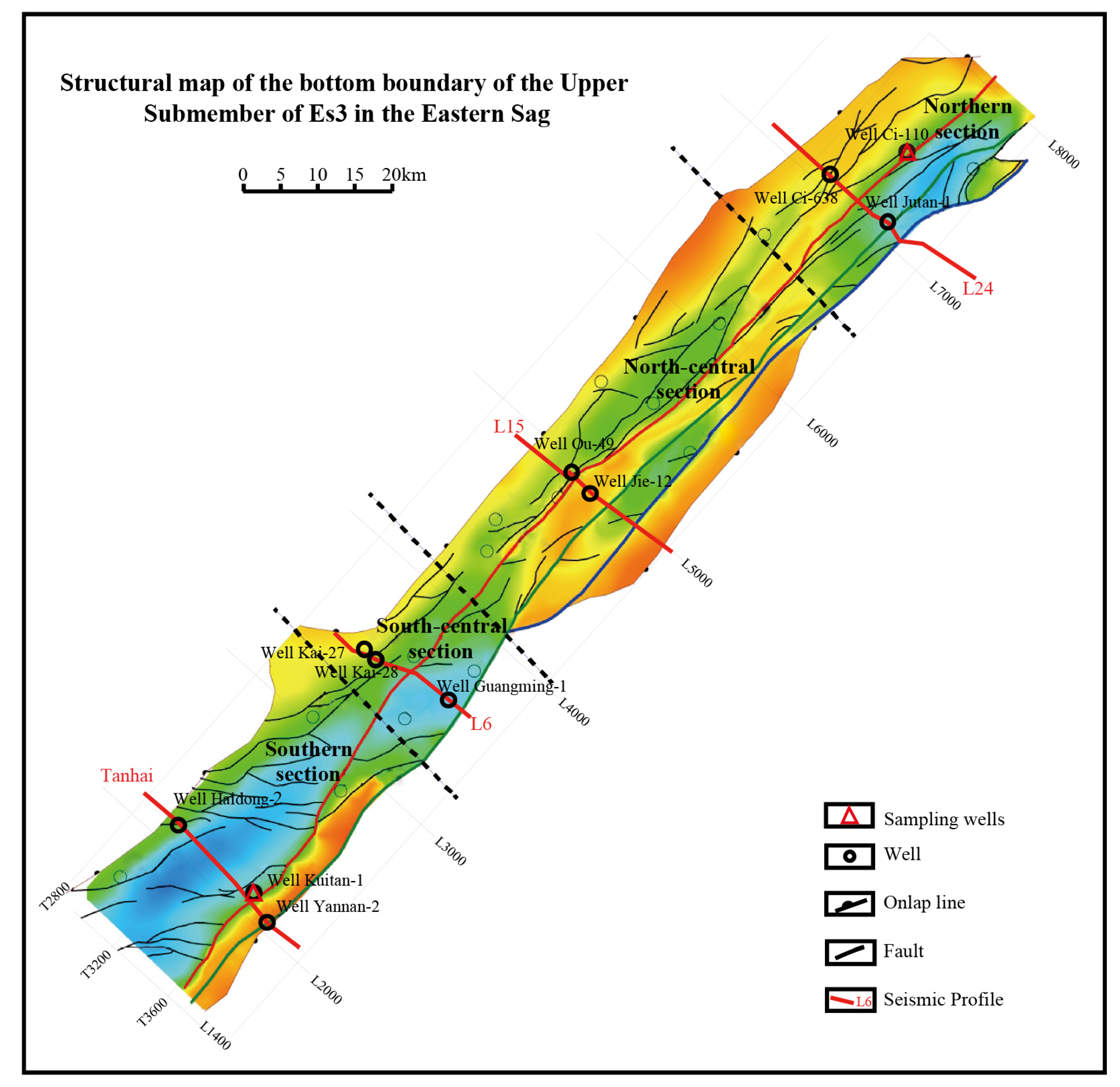
Affected by the historical activity of the Tanlu fault zone, the structure of the eastern sag is dominated by extension in the early stage and strike-slip compression in the late stage. Along the strike of the sag (NE–SW), the structural profiles exhibit both similarity and variance, primarily reflected in the attitude of major faults, fault displacement, superimposed patterns, and the morphological characteristics of the profiles. From south to north, the sag can be divided into four structural zones: the southern section (eastern Tanhai region), the south-central section (Erjiegu and Jiazhangsi sub-sag region), the north-central section (Sanjiepu buried hill region), and the northern section (Niujü and Qinglongtai sub-sag region) (
Figure 3). According to such a subdivision, we selected four corresponding typical seismic profiles (Tanhai, L6, L15, L24), and systematically interpreted and analyzed the structural styles at representative locations of the profiles.
2.1. Southern Section
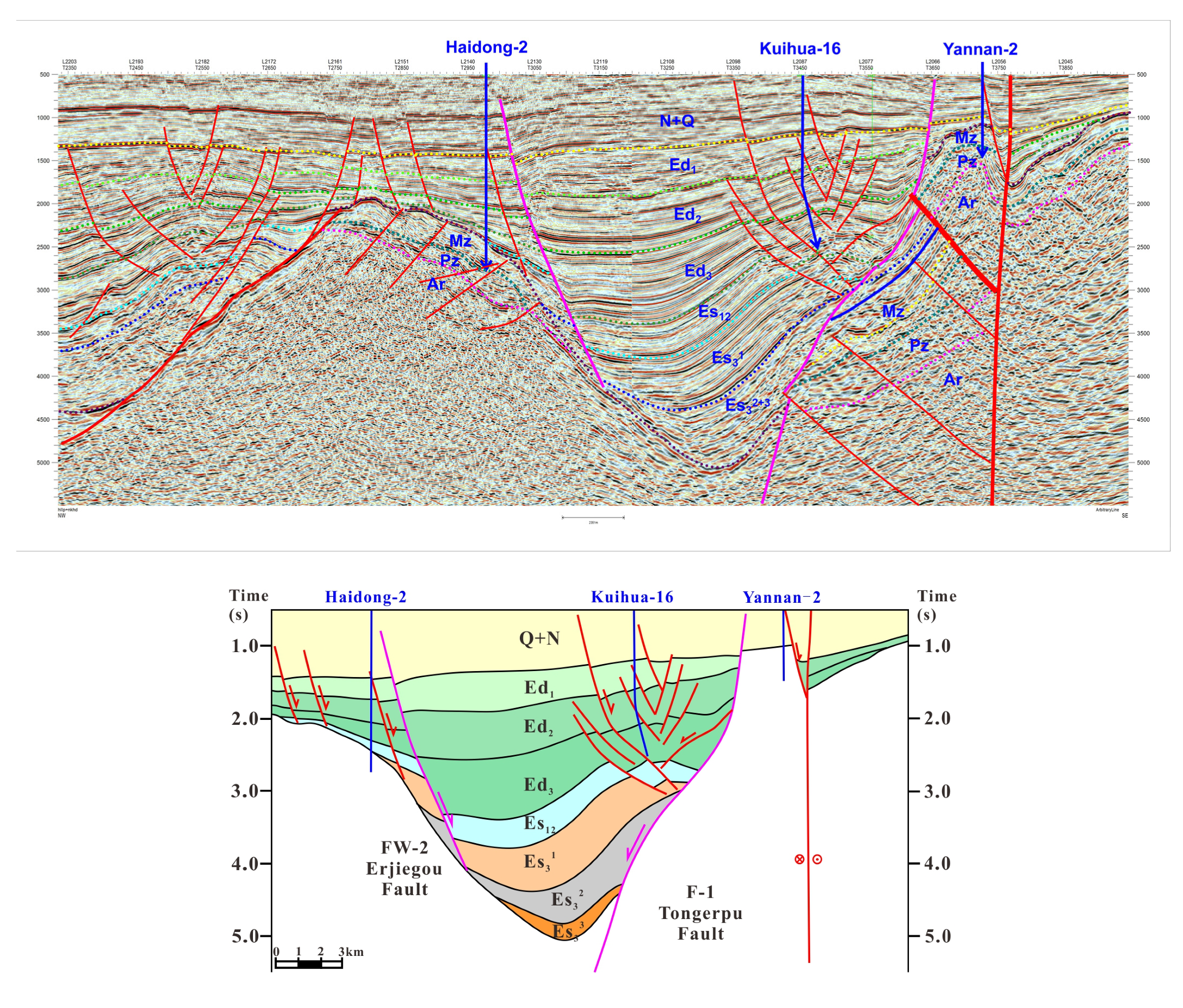
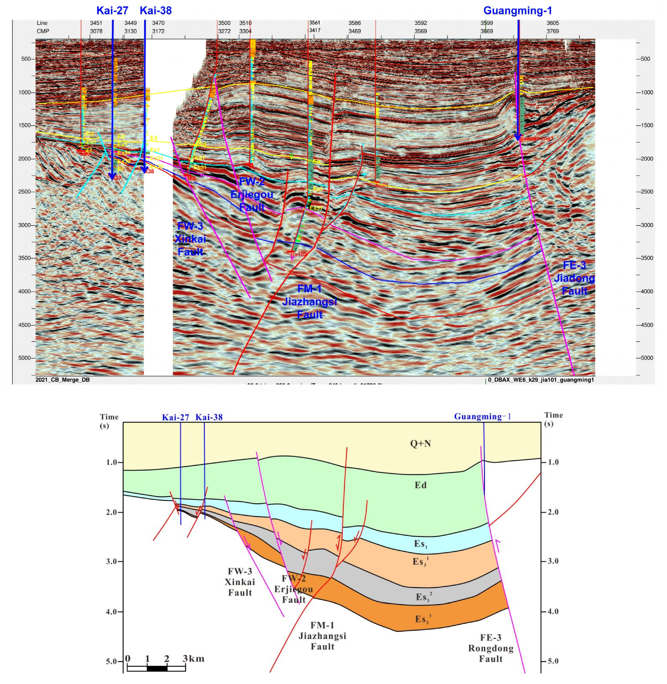
In the Tanhai seismic profile that exhibits the structures of the southern section (Tanhai in
Figure 3), three distinct structural units are identified: the western slope zone, the central deep depression zone, and the eastern buried hill zone. The overall structure exhibits a “one depression flanked by two uplifts” configuration, with the depression controlled by faults on both the east and west sides [
11]. Specifically in the central deep depression zone, anticlines are developed in the middle-shallow formations due to strike-slip compression in the late stage, and a flower structure is present in the eastern part of the depression [
12] (
Figure 4). The profile shows a highly developed fault system, including three sets of faults trending NE-SW, NW-SE, and approximately E-W. The main faults are the Tong’erpu Fault and the Erjiegu Fault, which have a NE-SW strike and are accompanied by several secondary faults. The profile exhibits prominent inherited structures of the Mesozoic, which have been further modified in the Cenozoic. The structural interpretation suggests that most of the faults began to develop at an early stage, with long lateral extension and large displacement, and were active over a long period, often accompanied by multiple episodes of volcanic activity.
2.2. South-Central Section
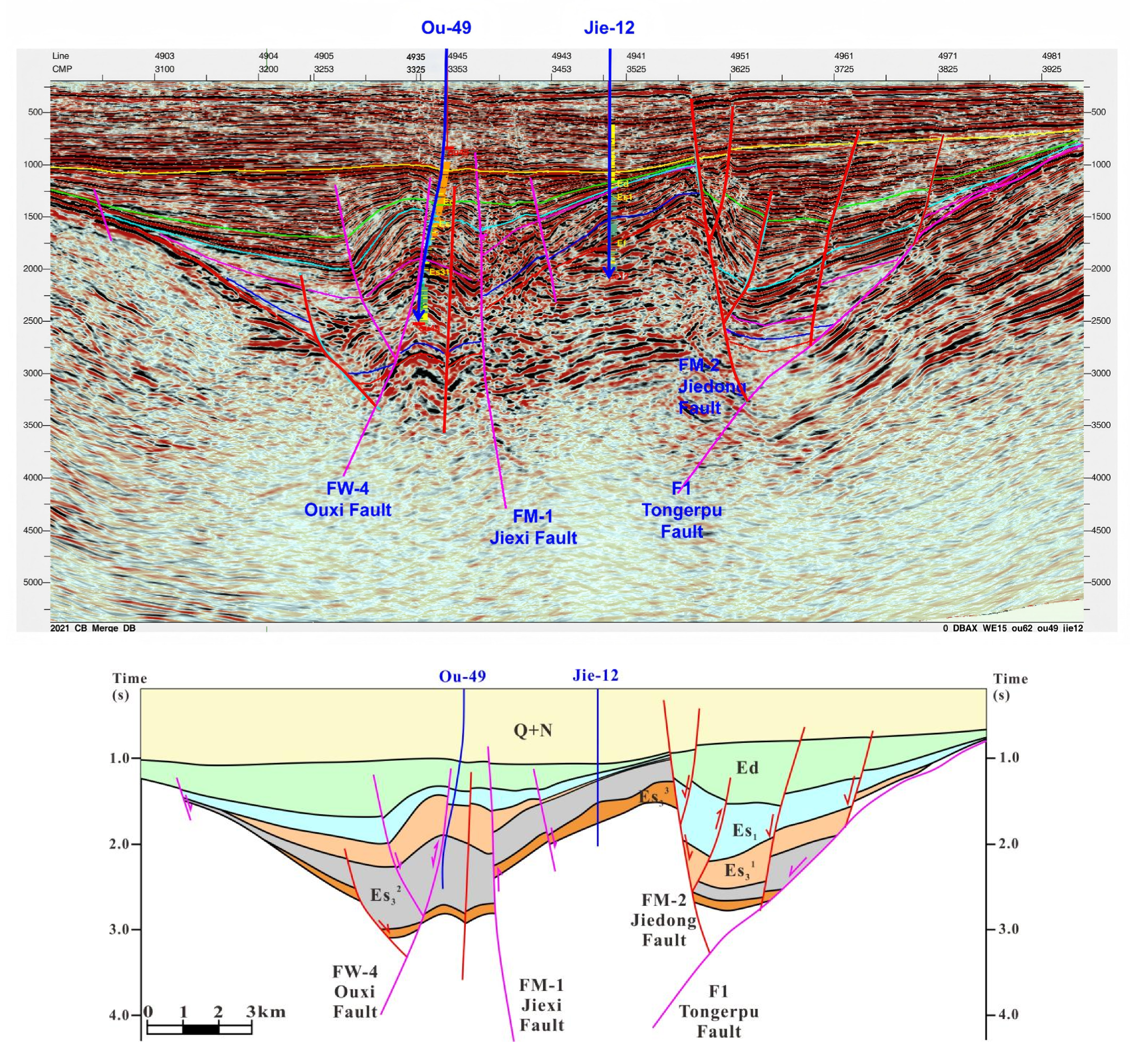
Profile L6 illustrates the underground structural characteristics of the south-central section of the sag. The sag basement is gentle, but it is still bounded by the NE-trending Erjiegu and Tong’erpu faults. Due to the intense dextral strike-slip activity in the late Dongying period, the Rongxi Fault experienced a reversal in dip direction, cutting through the earlier-formed Tong’erpu Fault. Consequently, the basin progressively expanded eastward from the Es
3 (Third Member of the Shahejie Formation) to the Dongying Formation (
Figure 5).
2.3. North-Central Section
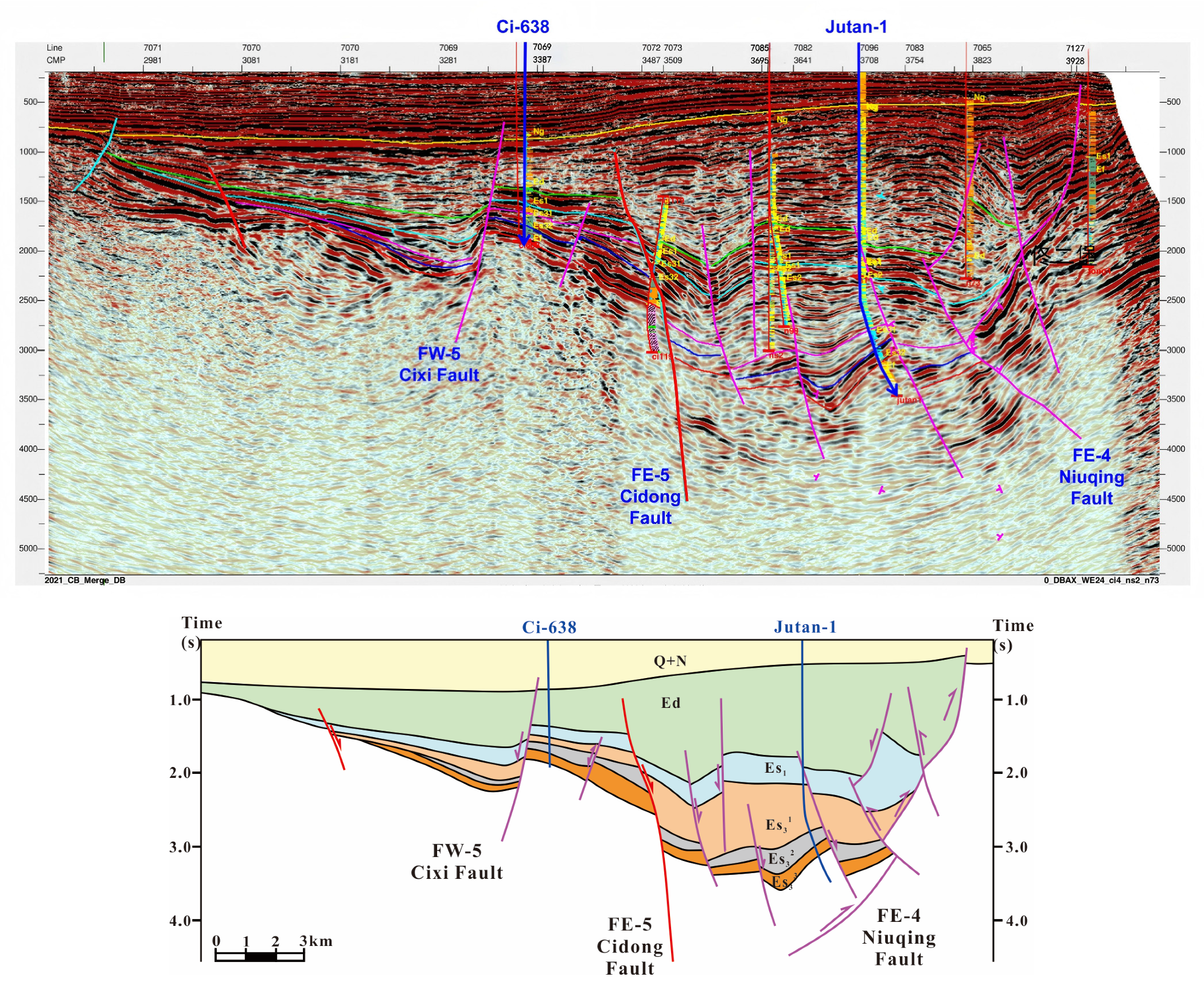
The north-central part of the sag (Profile L15) is characterized by a westward-dipping half-graben underground structure (
Figure 6). This region is bounded by multiple NE-SW trending faults, including the Cixi, Cidong, Niuqing, and Tong’erpu faults. During the early stages, intense fault-controlled depression dominated regional sedimentation. Since the late Dongying period, the region experienced strong dextral strike-slip deformation associated with a shift of tectonic regime, leading to positive structural inversions in the central and western parts of the profile (
Figure 6).
2.4. Northern Section
The northern part of the Eastern Sag (Profile L24) is structurally controlled by the evolution of the Cidong Fault and the Yingkou–Tong’erpu Fault. Specifically, the Sha-3 period (Es
3) marks the main extension and development period of the sag. During the early and middle stages, the sag was dominated by regional extensional stress. Under the combined influence of the Cidong and Yingkou–Tong’erpu faults, continuous stretching and subsidence of the sag led to the formation of the Niuju–Changtan deep faulted lake basin. Subsequently, in the late stage, intense strike-slip deformation resulted in multiple reverse faults developed in the vicinity of the Toutai-Shendanpu region and the Niuju structural belt, causing the formation of a series of thrust-nappe structures (
Figure 7).
3. Sandbox Modeling Experiment
To further provide the evidence of structural deformation for the structural analysis of the Eastern Sag, sandbox physical modeling on two representative regions (profiles Tanhai and L24) with significant structural contrasts was conducted. This forward modeling approach enables efficient tracking of various deformation stages within a short period of time [
13,
14,
15], thereby validating the rationality of the obtained seismic interpretation schemes. In addition, it allows both qualitative and quantitative assessments of the influence of different factors on shear deformation. The experimental results offer new insights into the genesis mechanism of strike-slip faults in the study section.
3.1. Model Setting
Material selection and rheological suitability: Quartz sand was used as the main analog material to simulate brittle sediments. The sand employed has a uniform grain size of 0.125–0.18 mm, a friction coefficient of approximately 0.6, and an internal friction angle of about 30°, closely resembling those of natural unconsolidated sediments [
16]. This choice allows the model to reproduce fault propagation and deformation patterns comparable to those in brittle crustal layers. A flexible rubber base was installed beneath the sand layers to simulate basement stretching and to ensure homogeneous strain transfer to the overlying deposits.
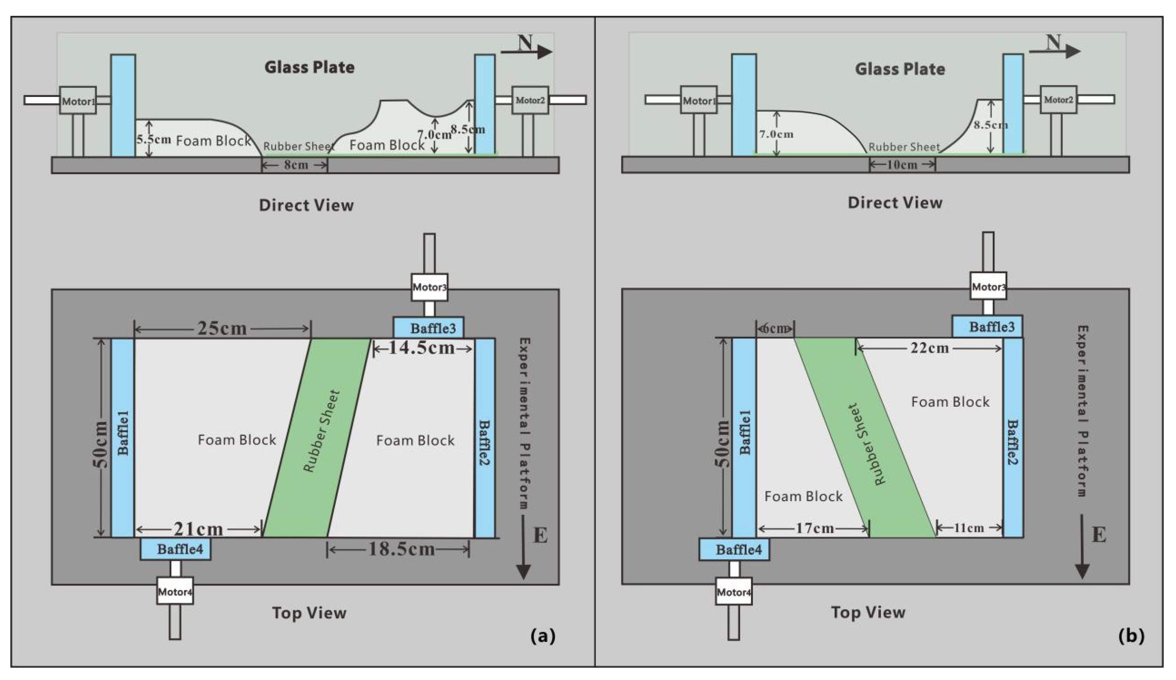
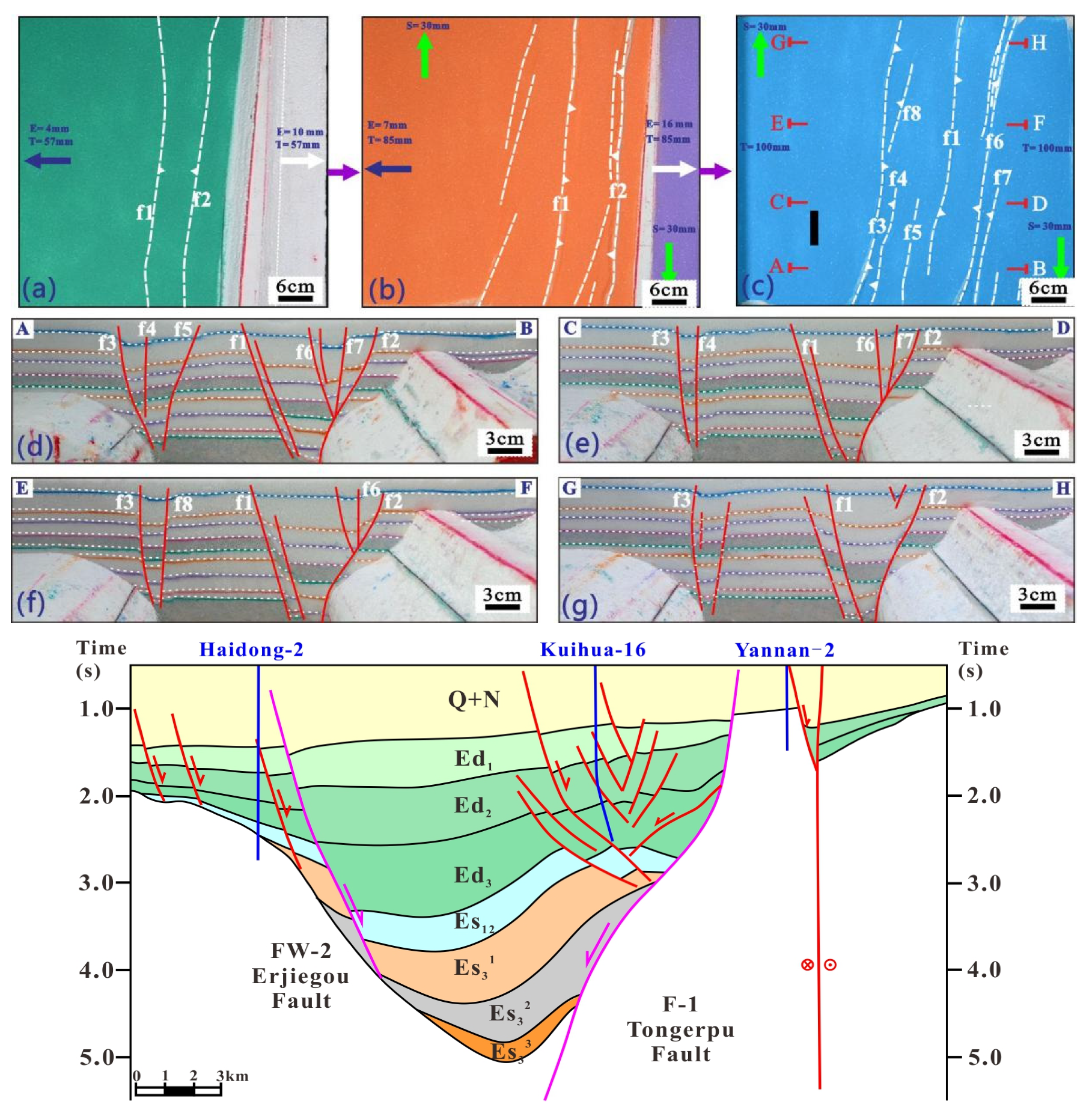
Model I (Southern section, Profile Tanhai): The experiment setup for Model I is shown in
Figure 8a. The sandbox measures 50 cm in length, 47.5 cm in width, and 10 cm in height. The boundary fault model was constructed by cutting polystyrene foam boards and scaled proportionally (1:100,000) based on the actual geological profile. To better simulate the structural deformation characteristics of the Eastern Sag, a stretchable and uniformly elastic rubber slab was placed at the bottom of the sandbox. Particularly, the left end of the slab was fixed with strong adhesive glue to the footwall of the left boundary fault, while the right end was attached to a movable sidewall to ensure uniform basement extension and transfer of extensional strain to the overlying sand layers. Additionally, an 8 cm wide zone was reserved between the two boundary fault models for accommodating deformation. Above the elastic rubber slab, unconsolidated quartz sand with a grain size of 0.125 to 0.18 mm was placed to simulate the deformation of sedimentary formations overlying the basin basement. During the experiment, as the movable wall pulls outward, the elastic rubber slab can be gradually stretched, causing the overlying sand layers to extend and hence generate displacements along the boundary faults.
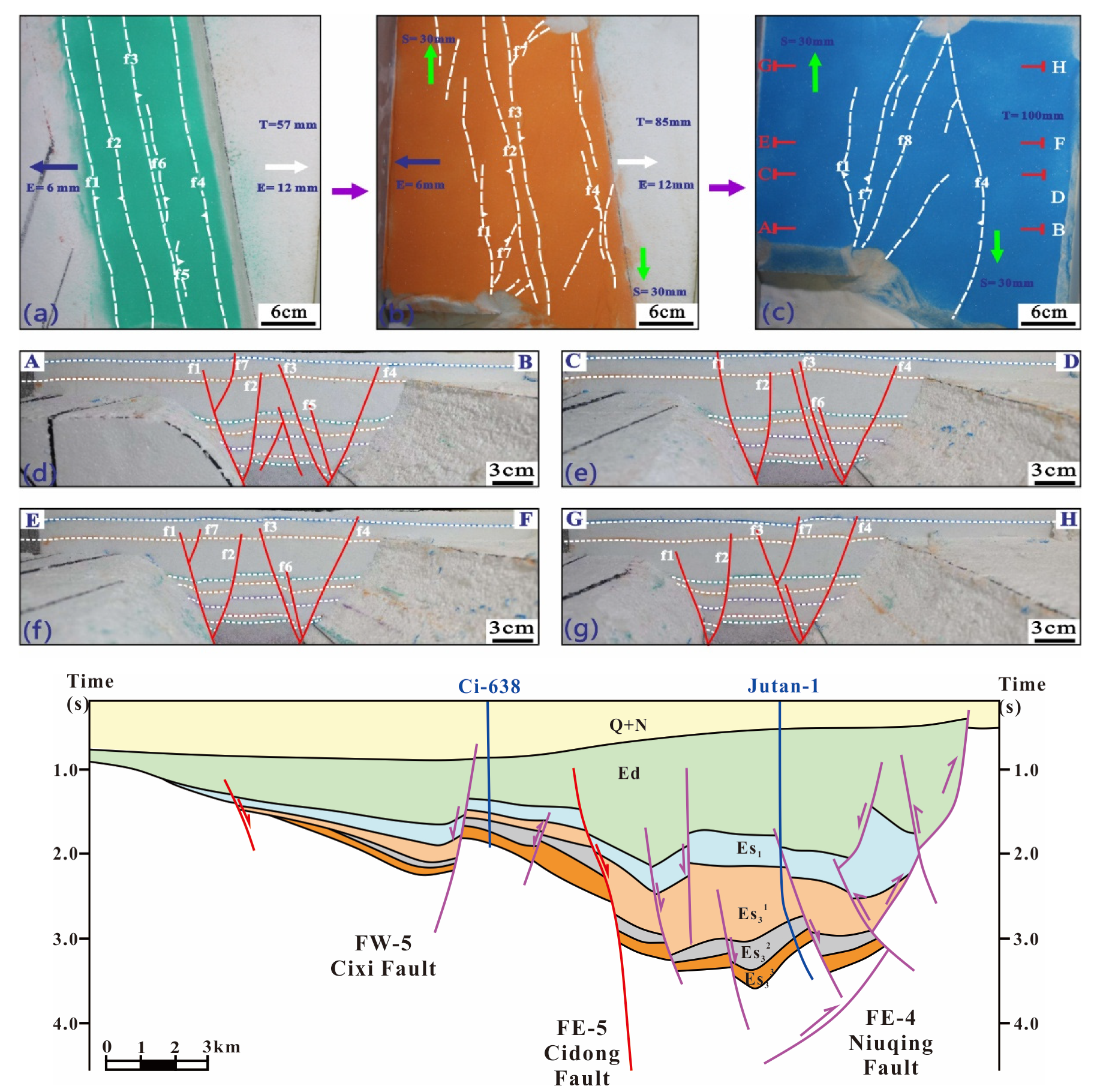
Model II (Northern section, Profile L24): The experiment setup for Model II is shown in
Figure 8b. The length, width, and height of the sandbox are 50 cm, 38 cm, and 10 cm, respectively. Similarly, this boundary fault model was constructed using polystyrene foam boards and was also scaled down with a proportion of 1:100,000. A rubber slab was laid on the bottom of the sandbox and fixed to the movable sidewalls on both the left and right sides, and a 10 cm-wide deformation zone was reserved between the two boundary faults. Furthermore, unconsolidated quartz sand was placed in the same way as the experimental material to simulate the deformation of sedimentary strata.
3.2. Simulation Steps
During the simulation, Model I was extended by 2.3 cm. The extension rates of Motor 1 and Motor 2 were 0.1 cm/min and 0.2 cm/min, respectively. The extension was halted after reaching a total displacement of 2.3 cm. By comparison, Model II was extended by 2.7 cm, with Motor 1 extending at 0.2 cm/min and Motor 2 at 0.1 cm/min. The extension of Model II was stopped once the displacement reached 2.7 cm. Subsequently, Motors 3 and 4, both operating at 0.1 cm/min, drove the foam boards at both ends of the model, thereby simulating the fault transition from extensional (before the late Dongying period) to dextral strike-slip (during the late Dongying period).
Model I: This model was constructed to verify the influence of pre-existing faults in the southern section (Profile Tanhai) on the overlying deposition layers and related deformation features. Nine layers of quartz sand were laid between two foam boards (simulating basement faults), with gray quartz sand representing the basement and white quartz sand representing the overlying formations. Adjacent layers were separated by differently colored sands as stratigraphic boundaries, with a total thickness of 10 cm. As shown in
Table 1, the steps are summarized as follows: Layers ① and ② of quartz sand were laid down, marked with green and red color, respectively, and Motor 2 stretched until 0.2 cm before stopping; Layers ③ and ④ were placed above the deformed sand layers, marked by purple and orange color, with Motors 1 and 2 simultaneously stretching at different rates until reaching 0.2 cm and 0.4 cm, respectively, then stopping; Layer ⑤, marked with a green color, was placed above the deformed sand layers, with Motors 1 and 2 again stretching simultaneously at different rates until 0.2 cm and 0.4 cm, respectively, before stopping; Layer ⑥, marked with an red color, was laid above the deformed sand layers, with Motors 1 and 2 stretching simultaneously at different rates until 0.3 cm and 0.6 cm, respectively, then stopping. Afterwards, Motors 3 and 4 drove the foam boards 3 cm to achieve right-lateral strike-slip motion; Layer ⑦, marked with a Purple color, was laid above the deformed sand layers, with Motors 3 and 4 again driving the foam boards 3 cm to realize right-lateral strike-slip motion. Finally, layer ⑧ and ⑨ marked with an orange + blue color and a 1 cm-thick white quartz sand cover layer was placed, and the model was moistened with water for 12 h before vertical profile slicing.
Model II: This model was constructed to validate the influence of pre-existing faults in the northern section (Profile L24) on the overlying deposition layers and related deformation features. In total, seven layers of quartz sand were laid between two foam boards (simulating basement faults). Similarly, gray quartz sand was used to simulate the basement, while white quartz sand was used for the overlying strata. Colored sand layers were placed between adjacent layers to mark stratigraphic boundaries, resulting in a total thickness of 10 cm. As shown in
Table 2, the deformation experiment was divided into six stages: First, layers ① and ② of quartz sand were placed, marked by green and red indicator layers, respectively. Motors 1 and 2 stretched at different rates until reaching 0.2 cm and 0.4 cm, then stopped. Next, layers ③ and ④ were placed above the deformed sand, marked with purple and orange, respectively. Motors 1 and 2 stretched simultaneously at different rates to 0.2 cm and 0.4 cm before stopping. Layer ⑤ was then added, with a green color, and Motors 1 and 2 again stretched at different rates to 0.2 cm and 0.4 cm, respectively. Layer ⑥ was added above the deformed sequence with an orange color. Motors 1 and 2 again stretched simultaneously to 0.3 cm and 0.6 cm, respectively, and then stopped. Following this, Motors 3 and 4 drove the foam boards 3 cm to simulate right-lateral strike-slip motion. Layer ⑦ was then placed, with a blue color, and Motors 3 and 4 again pushed the foam boards 3 cm to simulate continued right-lateral strike-slip. Finally, a 1 cm thick white quartz sand cover layer was added. The entire model was moistened with water for 12 h before vertical slicing for profile observation.
3.3. Modeling Results
Model I: As shown in the plan view evolution results (
Figure 9a–c), with continued extension driven by the motors, a half-graben structure began to appear on the surface of the sand body during the Sha-3 period. The Sha-1 Member shows an obvious inherited structure that gradually expanded. By the late Dongying period, the deformation stage of the sand transitioned from extensional to right-lateral strike-slip, with en echelon faults appearing at the surface. The strike-slip motion continued into the Guantao period and led to the superimposition of newly formed faults over earlier ones, resulting in the present-day complex fault system. Vertical cross-section images (
Figure 9d–g) show that the basin of the south Tanhai section is controlled by a single fault on the east side. From the Shahejie period to the late Dongying period, intense fault-controlled subsidence occurred in this region, producing listric and step-like fault geometries. With ongoing extensional deformation, the basin gradually expanded eastward from the Es
3 to the Dongying Formation, accompanied by the deposition of overlying strata. From the late Dongying period onward, a strong regional right-lateral strike-slip motion occurred, forming a series of flower-shaped structures in the eastern part of the basin. The fault assemblage seen in the vertical section reflects the influence of basement fault activity, characterized by a composite deformation pattern involving early extensional and later strike-slip extension phases. The stratigraphic framework of the south Tanhai section is shown in
Figure 9g.
Model II: With continued extension driven by the motors, a “one depression flanked by two uplifts” pattern (
Figure 10a–c) began to emerge at the sand surface during the Sha-3 period. The formation of the Sha-1 period developed in an inherited manner. By the late Dongying period, the deformation phase transitioned from extension to right-lateral strike-slip, and en echelon faults appeared on the surface. This strike-slip motion continued into the Guantao period, during which newly developed faults were superimposed on earlier ones, forming the current complex fault network. The vertical cross-section results (
Figure 10d–g) are generally consistent with the actual stratigraphic profiles. According to the sandbox physical simulation, it is evident that in the northern section, the basin was governed by early faulting followed by oblique compression in the late stage. From the Shahejie period to the late Dongying period, intense fault-controlled subsidence occurred in this region, with the profile exhibiting listric and shovel-shaped fault geometries. As the extension continued, the basin expanded eastward from the Sha-3 member to the Dongying Formation, controlling the deposition of the overlying strata. Beginning in the late Dongying period, strong regional right-lateral strike-slip activity developed. The Niuqing Fault in the eastern part was modified under this strike-slip regime. The fault assemblage observed in the profile reflects the influence of basement fault activity, presenting a composite structural style formed by the superimposition of early extensional deformation and later strike-slip extension (
Figure 10g).
4. Deformation Characteristics on Thin-Sections
Based on the results of sandbox modeling, the macroscopic structural style is characterized by early extensional deformation followed by superimposed strike-slip reactivation from south to north across the study area. To further elucidate the deformation history, thin-section analyses were conducted on subsurface rock samples collected near the boundary faults from the southern and northern sections, respectively (sample locations shown in
Figure 3).
The core sample acquired from Well Kuitan-1 (4171.75 m) in the southern section, adjacent to the Tong’erpu Fault (F1), mainly consists of fine-grained siliciclastic rocks composed of quartz and feldspar. Under the microscope, quartz grains display sutured and serrated grain boundaries, undulose extinction, and minor subgrain development, while feldspar grains show microfractures and irregular boundaries. These features indicate that the rock has experienced mechanical compaction and localized stress concentration. The coexistence of pressure-solution seams and grain fracturing suggests that deformation was formed during coupled compactional and brittle processes, consistent with fault-proximal deformation fabrics. Comparable grain-boundary suturing and intergranular seams have been reported in faulted sandstones of the Qaidam and Songliao basins, indicating episodic reactivation and sedimentary compaction during regional tectonic modification [
17].
The sandstone from Well Ci-110 (3950.00 m) in the northern section, located near the Cidong Fault (FE-5), exhibits similar textures but with coarser grains and poorer sorting. The framework grains are angular to sub-angular, and fractured quartz and feldspar fragments are cemented by secondary quartz and clay minerals. Occasional concavo–convex contacts, pressure-solution seams, and weak preferred orientations of elongate grains and microcracks record localized deformation and limited shear overprinting. These fabrics are clear evidence of cataclastic rearrangement under variable stress conditions, consistent with observations from sandstones governed by strike-slip faults in the North Sea Basin [
18]. Experimental compaction data further confirm that grain crushing and intergranular suturing strongly reduce porosity and permeability while leaving petrographic signatures of stress-induced rearrangement [
19] (
Figure 11a).
The sandstone illustrated in
Figure 11b, collected from Well Ci-110, shows a recycled-orogen provenance. It is medium- to fine-grained, poorly sorted, and is composed mainly of quartz, feldspar, and abundant lithic fragments, among which felsic mylonitic detritus is common. Grains are angular to sub-angular, displaying undulose extinction and subgrain development in quartz, while feldspars are partly sericitized and locally fractured. These mylonitic textures represent detrital fragments derived from adjacent metamorphic belts rather than in situ ductile deformation of the sedimentary rock. The compositional and textural features suggest that the sandstone was deposited from sediments with uplifted orogenic sources, consistent with a recycled-orogen origin [
20]. Regionally, this interpretation aligns with the Mesozoic crustal thickening and orogenesis produced by the collision between the North and South China blocks [
21], and is consistent with isotopic evidence for the subduction of South China lithosphere beneath the southeastern North China Block [
22]. The provenance thus links the sediment supply of the Liaohe Depression to the unroofing of nearby orogenic belts and supports a genetic model of post-orogenic collapse and extensional reactivation that governed the evolution of the Bohai Bay Basin.
Overall, the microstructures observed in both samples, including grain boundary suturing, intergranular pressure-solution seams, fracturing, and partial orientation of detrital grains, record the mechanical responses of siliciclastic rocks to repeated fault movements and sediment compaction. These textural features provide microstructural evidence that complements and supports the macroscopic interpretation: the southern section experienced fault-controlled subsidence and later transtensional deformation, whereas the northern section was dominated by right-lateral transpression during the late Dongying stage.
5. Structural Evolution and Controlling Mechanisms
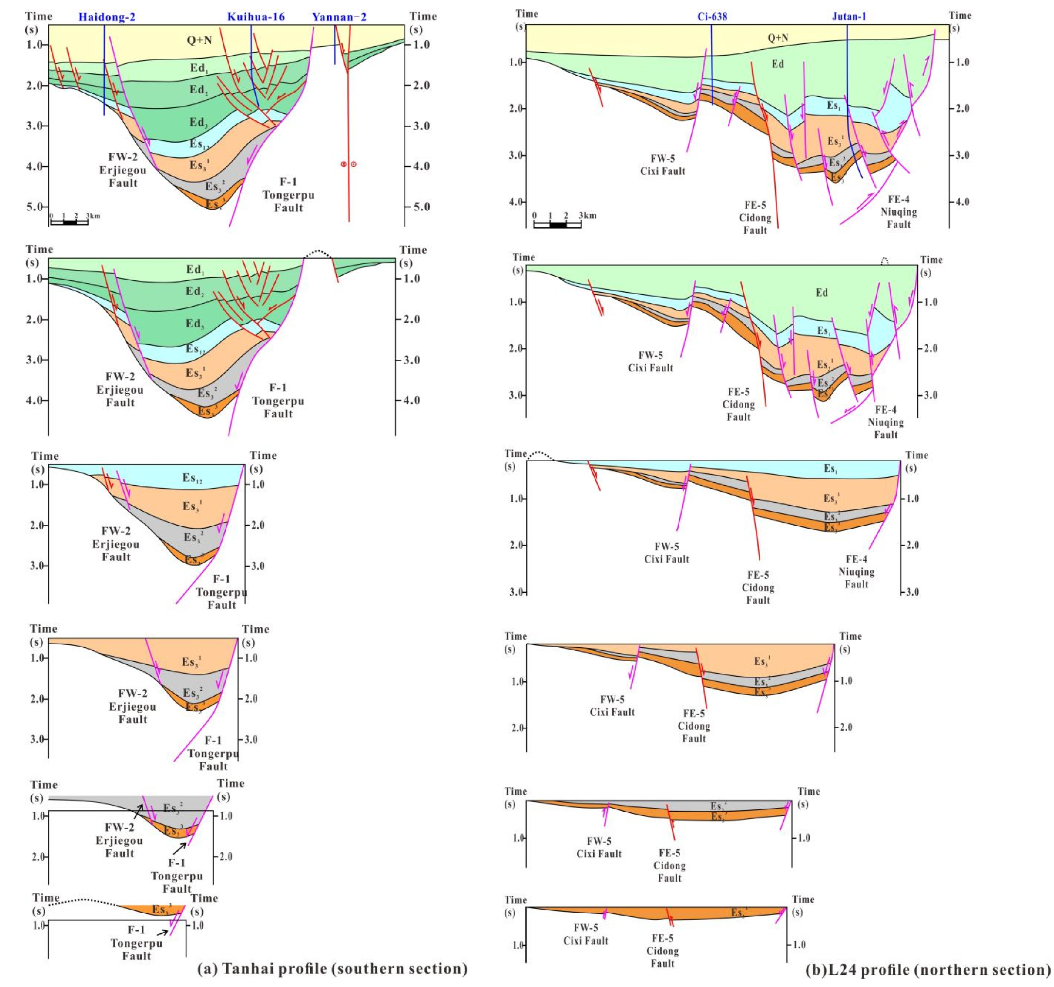
The integration of thin-section analysis with seismic interpretation and sandbox modeling leads to a multi-scale understanding and reconstruction of the deformation history and fault reactivation process of the Eastern Sag (
Figure 12):
Intense fault-depression (deposition period Es3): The Yingkou–Tong’erpu normal fault acted as the main boundary-controlling fault during this stage. The overall basin was structurally a half-graben that is bounded by the fault to the southeast and overlaps the strata to the northwest. The boundary fault controlled the subsidence and sedimentation processes. The activity of secondary basement faults was weak, and the faults within the overlying layer were poorly developed. During this stage, the Niuju–Changtan deep faulted lake basin began to form due to strong extensional tectonism along the southeastern margin. Continuous fault displacement and rapid subsidence created a deep lacustrine depocenter adjacent to the main boundary fault, where thick fine-grained sediments accumulated under relatively low-energy lacustrine conditions.
Weak fault-depression (deposition period Es1): During this stage, although the activity of boundary faults controlled regional sedimentation and settlement to some extent, the basin exhibited a broad fault-controlled subsidence structure, with the settlement-deposition center located in the axial region. The Yingkou-Tong’erpu fault was significantly modified by strike-slip motions, forming a series of extensional and strike-slip secondary faults.
Transition from fault depression to subsidence (deposition period Ed): Strong strike-slip activity of deep faults led to structural inversion of the basin, resulting in pronounced differential uplift and subsidence. The southern part of the sag exhibits transtensional characteristics (i.e., strike-slip and pull-apart), while the northern part shows obvious transpressional features. Weak crustal extension, superimposed on strike-slip motion along the basement faults, controlled the subsidence–sedimentation processes during this stage. The boundary fault, Yingkou-Tong’erpu Fault, no longer played a dominant role in the basin evolution. Instead, the southern basin was influenced by strike-slip and pull-apart mechanisms, leading to the development of south-dipping, east–west-trending, staircase-shaped faults.
Weak strike-slip and thermal subsidence (deposition period Ng + Q): The basin in this stage was structurally characterized by subsidence-induced deformation. Prominent inherited structures following the strike-slip deformation in the Dongying period can be observed, manifested as the Guantao basement layer being offset by both transpressional and transtensional faults. The northern section inherited a transpressional structural regime, where the sedimentary strata during this stage were lithologically homogeneous, mainly fluvial sand and conglomerate deposits unconformably overlying the Neogene strata. In contrast, the southern section inherited a transtensional regime, characterized by the development of normal faults.
6. Discussion
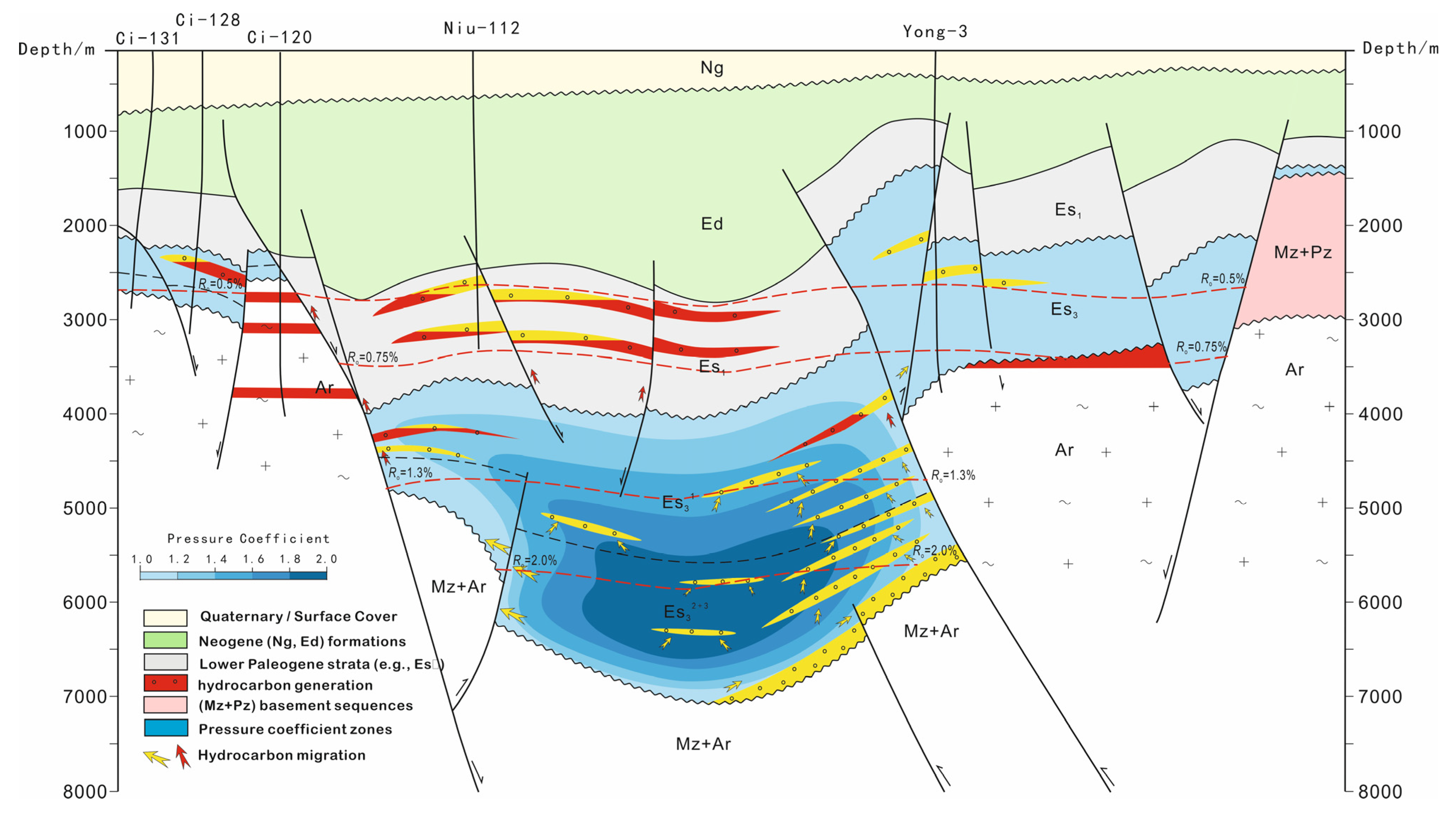
The fault system not only governs the structural framework and its evolution of the study area, but may also play a critical role in hydrocarbon migration and accumulation. Due to the long-term activity of the Cidong, Niuqing, and Cixi faults in the northern part of the study section, multiple stratigraphic units have been penetrated, which greatly facilitated vertical migration and accumulation of hydrocarbons along faults. As a result, hydrocarbons are generally distributed across multiple formations and over long well sections. Proven reserves indicate that the hydrocarbons are present from 1600 m to 4400 m, with most accumulations concentrated between 2000 m and 3300 m. Although this region has experienced multiple phases of intense tectonic activity over a long geological period, there was no large structural modification after hydrocarbon accumulation, and most primary hydrocarbon reservoirs have been well preserved. From the perspective of depth, hydrocarbons are continuously distributed in various types of traps below the caprock Es
1, covering a large depth range. In the southern part of the sag, the interplay of transtensional deformation and inherited normal faulting facilitated the formation of local depocenters and stratigraphic pinch-out traps. In contrast, the northern section, dominated by transpressional deformation, developed positive flower structures and local uplift zones that served as structural highs for hydrocarbon accumulation. This structural duality suggests that the middle to deep intervals beneath the Niuju–Changtan Sag and adjacent areas are the most favorable targets for future exploration (
Figure 13).
The multi-phase deformation and strike-slip reactivation with contrasting domains not only reorganized the fault system but may also controlled the spatial distribution of reservoir, seal, and migration pathways. Microstructural observations of fault-related siliciclastic rocks further reveal localized fracturing, pressure-solution seams, and weak grain alignment, suggesting repeated episodes of brittle reactivation that enhanced fault permeability during certain tectonic stages while maintaining sealing capacity at others. This dynamic evolution of fault permeability provides a reasonable explanation for the observed vertical and lateral heterogeneity of hydrocarbon accumulation in the Eastern Sag.
Although the current exploration still focuses on shallow to medium reservoirs, deep targets associated with fault intersections, buried-hill traps, and tight formations are strongly recommended to be prioritized in future prospecting. The combined tectonic, structural, and microstructural analyses in this study provide an improved theoretical framework for predicting hydrocarbon accumulation zones and optimizing exploration strategies in the Eastern Sag and analogous strike-slip basins.
7. Conclusions
Based on the integration of seismic interpretation, sandbox modeling, and thin-section analysis, this study reconstructs the structural evolution and identifies the main controlling mechanisms of the Eastern Sag in the Liaohe Depression. The conclusions were derived through cross-scale evidence linking basin-scale deformation patterns with fault-zone microstructures.
1. Influenced by the tectonic movements of the Bohai Bay Basin, the Eastern Sag underwent multi-stage evolution in the Cenozoic, including two phases of fault depression, transition from fault-depression to subsidence, and thermal subsidence combined with strike-slip modification. During the Sha-4 period (Es4), the western branch of the Tanlu Fault first reactivated under the NW-SE-oriented extension, resulting in the absence of deposition in the Eastern Sag. During the Sha-3 period (Es3), NNW–SSE extension led to the simultaneous reactivation of boundary faults of both the eastern and western sags, forming an “east–west zonation” of the Liaohe Depression. During the Dongying period, nearly N-S extension triggered strike-slip motion of the pre-existing faults in the Eastern Sag, leading to the transtension (pull-apart) deformation of the right-stepping section of the basement faults and the transpression deformation in the left-stepping section. As a result, an obvious north–south segmentation of the regional tectonic framework occurred.
2. The structural evolution of the northern part of the Eastern Sag also experienced the transition from fault-depression to a large subsidence, and its development was primarily controlled by the evolution of the Cidong fault and the Yingkou-Tong’erpu fault, which are two major sag-controlling faults. The Sha-3 period marks the main phase of sag extension. During the early and middle sub-stages of the Sha-3 period, regional extensional stress dominated. Under the combined effect of the Cidong and Yingkou-Tong’erpu faults, continuous extensional subsidence occurred, leading to the formation of the Niuju–Changtan deep faulted lake basin. During the late sub-stages of the Sha-3 period, the Niuju structural belt was uplifted along with the overall elevation of the Eastern Sag, accompanied by local erosion. During the Sha-2 period, a new phase of extension and fault-depression began, although such tectonic activities were weak. During the Sha-1 period, large-scale subsidence of the lake basin occurred, representing the most extensive development of Paleogene lake basins in the Eastern Sag. During the Dongying period, regional dextral compressional stress led to the development of multiple reverse faults between the Toutai–Shendanpu structure and the main body of the Niuju structural belt. Microscopic evidence from fault-zone rocks indicates that these structures experienced repeated brittle reactivation under varying stress regimes, consistent with the multi-phase tectonic transition inferred from the macroscopic framework. These reverse faults jointly formed a series of thrust-nappe structures. By the end of the Dongying period, the structural framework of the northern part of the Eastern Sag was basically established.
3. The southern section of the Eastern Sag is characterized by three sets of secondary faults trending NE-SW, nearly E-W, and N-S. Among them, the NE-SW-trending faults were primarily associated with the intense activity and kinematics of the Yingkou-Tong’erpu Fault and the Erjiegu Fault. These faults are arranged en echelon, characterized by a long period of development and long extension. They were remarkably active during the Sha-3 period and terminated at the Dongying period. The nearly E-W and N-S trending faults are mostly feather-shaped, distributed on both sides of the major faults and intersecting them at acute angles. Their development was governed by the kinematics of the related main faults. When the main faults experienced extensional deformation, the associated secondary faults formed relatively early (mostly formed during the Sha-3 period and generally became inactive by its end). Some of these faults exerted a certain degree of control on local sedimentation and structural development. By contrast, when the main faults were in the strike-slip domain, the secondary faults developed later, with smaller offsets and shorter lengths. Most of these faults were induced by the activity of the Jiazangsi Fault, exerting no or little influence on sedimentation or structural evolution, but rather served to complicate the regional structural configuration. Overall, although these fault sets differ in terms of their development stages, they all played essential roles in modifying the structural framework, which led to obvious hydrocarbon redistribution.
Author Contributions
Conceptualization, I.C.; Methodology, G.D.; Validation, G.D.; Investigation, X.Y.; Resources, F.Y.; Data curation, X.Y.; Writing—original draft, X.Y.; Writing—review & editing, I.C. and A.T.; Supervision, F.Y., I.C. and A.T.; Project administration, F.Y.; Funding acquisition, A.T. All authors have read and agreed to the published version of the manuscript.
Funding
This work was supported by the National Natural Science Foundation of China (Grant No. 42072144), the grant PID2021-12246NB-C22 of MICIU/AEI/10.13039/501100011033, and by FEDER, UE, and the Catalan Council to the Grup Consolidat de Recerca Reconegut Geologia Sedimentària (2021 SGR-Cat 00349).
Data Availability Statement
The original contributions presented in this study are included in the article. Further inquiries can be directed to the corresponding author.
Conflicts of Interest
Author Guanjian Duan was employed by the company China Petroleum Group Great Wall Drilling Engineering Co., Ltd. The remaining authors declare that the research was conducted in the absence of any commercial or financial relationships that could be construed as a potential conflict of interest.
References
- Jolivet, L.; Faccenna, C.; Becker, T.; Davaille, A.; Lasseur, E.; Briais, J.; Koptev, A.; Sternai, P.; Le Pourhiet, L. Continental rifts and mantle convection. Earth Sci. Rev. 2025, 270, 105243. [Google Scholar] [CrossRef]
- Zhou, S.-D.; Wang, X.-L.; Du, D.-H.; Wu, B.; Xu, X.; Hou, Z.-Q. Spatiotemporal distribution of Mesozoic A-type granites and numerical modeling reveal episodic and progressive lithospheric extension in SE China. Lithos 2025, 514–515, 108214. [Google Scholar] [CrossRef]
- Lazos, I.; Sboras, S.; Pikridas, C. Tectonic geodesy synthesis and review of the North Aegean region, based on the strain patterns of the North Aegean Sea, Strymon basin and Thessalian basin case studies. Appl. Sci. 2023, 13, 9943. [Google Scholar] [CrossRef]
- Eppelbaum, L.; Katz, Y.; Kadirov, F.; Guliyev, I.; Ben-Avraham, Z. Geodynamic, Tectonophysical, and Structural Comparison of the South Caspian and Levant Basins: A Review. Geosciences 2025, 15, 281. [Google Scholar] [CrossRef]
- Li, H.-Y.; Han, H.-W.; Jiang, Y.-L.; Shen, C.; Guo, Q. Relationship between fault-caprock configuration and vertical hydrocarbon distribution in the central-southern segment of Liaohe Eastern Sag. Spec. Oil Gas Reserv. 2025, 32, 79–87. [Google Scholar]
- Qi, J.-F.; Li, X.-G.; Yu, F.-S.; Yu, T. Cenozoic structural deformation of the western Liaodong Bay Sub-basin and the expression of the Tan-Lu fault zone. Sci. China Earth Sci. 2013, 43, 1324–1337. [Google Scholar] [CrossRef]
- Liu, X.-J.; Xie, Q.-B.; Xu, X.; Li, J.; Wang, L.; Song, Y. Sequence stratigraphy and sedimentary facies of the Paleogene Shahejie Formation in the eastern sag of the Liaohe Basin, NE China. J. Northeast. Pet. Univ. 2015, 39, 13. [Google Scholar]
- Zhao, J.-P. Geochemical characteristics of Paleogene source rocks in the central-southern segment of the eastern Liaodong Bay Sub-basin. J. Shengli Coll. China Univ. Pet. 2020, 34, 11–14. [Google Scholar]
- Yang, Q.-N. Reservoir characteristics of volcanic rocks in the 3rd member of the Shahejie Formation, southern part of the eastern Liaodong Bay Sub-basin. China Pet. Chem. Stand. Qual. 2018, 38, 121–124. [Google Scholar]
- Li, S.-W.; Huang, Y.-L.; Feng, Y.-H.; Guo, Y.; Zhang, B.; Wang, P. Cenozoic extensional-strike-slip tectonics and fault architecture in the eastern sag of the Liaohe Basin, NE China. Chin. J. Geophys. 2020, 63, 612–626. [Google Scholar] [CrossRef]
- Zhou, Y.; Ji, Y.-L.; Meng, Q.-A.; Wan, H.; Zhang, G.; Ren, Y.; Yan, K.; Liang, T.; Chen, F.; Qiang, Z. Early Cretaceous tectono-paleogeomorphology controlling sandbody distribution in the Tanan Sag, Tamtsag Basin, Mongolia. J. Palaeogeogr. 2022, 24, 493–511. [Google Scholar] [CrossRef]
- Ma, J.-L.; Zhang, B.-Q. Tectono-sedimentary characteristics and hydrocarbon accumulation patterns in the Tangyuan Fault Depression. Pet. Geol. Exp. 2006, 28, 220–224. [Google Scholar]
- Hu, Q.-Y.; Dong, D.-W.; Yang, J.-L.; Gao, L.; Kong, X.; Yang, G.; Jiao, X. Structural analysis and analogue modelling of Block Zhong-4 in the Junggar Basin, NW China. Sci. Technol. Eng. 2020, 20, 3898–3907. [Google Scholar]
- Zhang, J.-Q.; Yu, F.-S.; Pang, F.-J.; Wang, Q.; Wang, Y. Development characteristics and physical modelling of strike-slip faults in the Yongjin area, central Junggar Basin. Acta Geol. Sin. 2024, 98, 397–420. [Google Scholar] [CrossRef]
- Mu, L.-H.; Gao, B.; Yu, F.-S.; Wu, X.; Zhang, J.; Chen, S. Analogue modelling of parallel conjugate faults and its application to the Nanpu Sag, Bohai Bay Basin. Geotecton. Metallog. 2018, 42, 988–1000. [Google Scholar] [CrossRef]
- Koyi, H. Analogue modelling: From a qualitative to a quantitative technique—A historical outline. J. Pet. Geol. 1997, 20, 223–238. [Google Scholar] [CrossRef]
- Liang, S.; Gan, W.; Wang, C. Characterizing subseismic faults from SK-2 drilling core (2900–4200 m): Implication for reservoir transmissibility and regional tectonic evolution, Songliao Basin. Interpretation 2020, 8, SG1–SG11. [Google Scholar] [CrossRef]
- Fisher, Q.J.; Knipe, R.J.; Worden, R.H. Microstructures of deformed and non-deformed sandstones from the North Sea: Implications for the origins of quartz cement in sandstones. In Quartz Cementation in Sandstones; Wiley-Blackwell: Hoboken, NY, USA, 2009; pp. 129–146. [Google Scholar]
- Chuhan, F.A.; Kjeldstad, A.; Bjørlykke, K.; Høeg, K. Porosity loss in sand by grain crushing—Experimental evidence and relevance to reservoir quality. Mar. Pet. Geol. 2002, 19, 39–53. [Google Scholar] [CrossRef]
- Zhang, K.J.; Li, B.; Wei, Q.G.; Cai, J.X.; Zhang, Y.X. Proximal provenance of the western Songpan-Ganzi turbidite complex (Late Triassic, Eastern Tibetan Plateau): Implications for the tectonic amalgamations of China. Sediment. Geol. 2008, 208, 36–44. [Google Scholar] [CrossRef]
- Zhang, K.J. North and South China collision along the eastern and southern North China margins. Tectonophysics 1997, 270, 145–156. [Google Scholar] [CrossRef]
- Yang, D.B.; Xu, W.L.; Pei, F.P.; Yang, C.H.; Wang, Q.H. Spatial extent of the influence of the deeply subducted South China Block on the southeastern North China Block: Constraints from Sr–Nd–Pb isotopes in Mesozoic mafic igneous rocks. Lithos 2012, 136–139, 246–260. [Google Scholar] [CrossRef]
| Disclaimer/Publisher’s Note: The statements, opinions and data contained in all publications are solely those of the individual author(s) and contributor(s) and not of MDPI and/or the editor(s). MDPI and/or the editor(s) disclaim responsibility for any injury to people or property resulting from any ideas, methods, instructions or products referred to in the content. |
© 2025 by the authors. Licensee MDPI, Basel, Switzerland. This article is an open access article distributed under the terms and conditions of the Creative Commons Attribution (CC BY) license (https://creativecommons.org/licenses/by/4.0/).
