Article

Geochemistry, Mineralogy, and Coal Petrology of No. 4 Coal in Sandaoling Mine, Turpan-Hami Basin, Northwest China: Provenance and Peat Depositional Environment

1
College of Geoscience and Surveying Engineering, China University of Mining and Technology, Beijing 100083, China
2
State Key Laboratory of Coal Resources and Safe Mining, China University of Mining and Technology, Beijing 100083, China
3
School of Geographical Sciences, Hebei Key Laboratory of Environmental Change and Ecological Construction, Hebei Normal University, Shijiazhuang 050024, China
4
China National Administration of Coal Geology (CNACG), Beijing 100038, China
*
Author to whom correspondence should be addressed.
Minerals 2023, 13(7), 837; https://doi.org/10.3390/min13070837
Submission received: 15 May 2023 / Revised: 28 May 2023 / Accepted: 20 June 2023 / Published: 21 June 2023
(This article belongs to the Special Issue Critical Metal Minerals in Coal)

Abstract

:
The Turpan-Hami Basin is one of the three coal-accumulating basins in Xinjiang. There is coal, natural gas, petroleum, sandstone-type uranium ore, and other ore resources in the Jurassic strata developed inside. This study aims to gain a deeper understanding of the formation process of ore resources in the Turpan-Hami Basin by studying the provenance and depositional environment of No. 4 coal in the Sandaoling Mine. The results show that No. 4 coal is extra-low ash yield and extra-low sulfur coal. Compared with common Chinese coals and world hard coals, the trace element content in No. 4 coal is normal or depleted. The minerals in coal are mainly clay minerals, silica and sulfate minerals, and carbonates. The diagrams of Al2O3, TiO2, Sr/Y, L,a/Yb, and the REY geochemical features indicate that the Paleozoic intermediates and felsitic igneous rocks in Harlik Mountain and Eastern Bogda Mountain are the main provenance of No. 4 coal. The syngenetic siderite, Sr/Ba, Th/U, total sulfur content, and maceral indices indicate that No. 4 coal was formed in a salt-lake environment, and the climate changed from dry and hot to warm and humid.

1. Introduction

The geochemical characteristics, mineralogy, and petrology of coal have been extensively studied by a number of researchers resulting in many new advances in the formation process of coal and the critical elements in it [1,2,3,4,5,6,7,8,9,10,11,12]. The Turpan-Hami Basin is one of the 10 super-large coal-accumulating basins in the world, with coal resources of more than 5000 × 108 t [13]. In recent years, the predecessors have studied the Jurassic coal-bearing stratum in the exploration of the Turpan-Hami Basin and gained a great deal of understanding of the ancient structure, paleogeography, basin evolution, stratigraphic sequence, and coal accumulation evolution [13,14,15,16,17,18,19,20,21,22,23].
The Jurassic coal-bearing stratum of Turpan-Hami Basin mainly occurs in the northern basin. There are various ore resources of petroleum, natural gas, coal, and sandstone-type uranium in the basin [1,24,25,26,27,28]. The Sandaoling Mine is an important Jurassic coal mine, with coal reserves up to 186 × 108 t, with a relatively shallow burial depth, most of which is within 2500 m. Previous studies conducted on the Sandaoling Mine have primarily concentrated on physicochemical properties, process characteristics, natural gas, coal facies, and fossil plants [29,30,31,32]. However, these studies have only examined coal-forming plants and peat bog types of No. 4 coal, and the lack of detailed studies on provenance and sedimentary environment limits the comprehensive understanding of ore resources in the Turpan-Hami Basin. Previous studies have shown that the maceral index should be carefully used in the study of sedimentary environments and paleoclimate [2], and numerous studies have demonstrated the efficacy of utilizing geochemistry and mineralogy to investigate provenance and sedimentary environments [1,2,3,33,34,35,36,37,38,39,40,41,42]. By combining the two methods with coal petrology and applying them to the study of No. 4 coal in the Sandaoling Mine, a better understanding of ore resource formation in the Turpan-Hami Basin can be achieved. Therefore, this study sampled and tested No. 4 coal in the Sandaoling Mine to reveal its geochemistry, mineralogy, and coal-petrography characteristics, providing a theoretical basis for the coal potential evaluation. Further study on the provenance and depositional environment of coal deepens the comprehensive understanding of sedimentary evolution and ore resources in the Turpan-Hami Basin.

2. Geological Setting

The Turpan-Hami Basin is located at the confluence of Kazakhstan, Siberia, and the Tarim ancient plate. The basement of the basin is a part of the Junggar-Turpan secondary plate in the Kazakhstan ancient plate [13]. Nine tectonic units are identified within the basin (five depressions, four uplifts) (Figure 1). After the formation of the main part of the Turpan-Hami Basin at the end of the Late Paleozoic, the basin underwent three major sedimentary evolutions: Late Permian epoch—Triassic period, Jurassic period, and Late Mesozoic—Cenozoic sedimentary sequences of three geological periods. The Tarim plate collided with the Siberian plate at the end of the Carboniferous Period. It led to the disappearance of the Paleo-Tianshan Ocean and the rise of Harlik Mountain. Subsequently, the Bogda tectonic belt connected the Turpan-Hami Basin with the Junggar Basin in an intracontinental rift. Until the Middle Jurassic, Bogda and Harlik Mountains were uplifted and became important provenance areas of the Turpan-Hami Basin in the Mesozoic and Cenozoic [15,23,43].
The Hami Depression is the main sedimentary depression in the Turpan-Hami Basin. The Sandaoling Mine is located at the northwest margin of the Hami depression (Figure 1). The main coal-bearing stratum is the Xishanyao Formation of the Middle Jurassic, with six coal seams, of which No. 4 coal seam has the largest thickness and is the main recoverable coal (Figure 2). From the early Jurassic to the Middle Jurassic, the main sedimentary environment of the basin was lacustrine facies, with the overall performance of the lacustrine basin filling and expanding. The sedimentary environment in the Sandaoling Mine is a braided river-shallow lake-underwater delta, and the sedimentary environment of the Xishanyao Formation is an underwater delta [19,30].

3. Sampling and Analytical Techniques

In this study, 45 samples of the No. 4 coal seam of the Xishanyao Formation in the Middle Jurassic were collected in the Sandaoling open-pit coal mine, including 41 coals (SDL-1 to SDL-41), 2 roofs (SDL-R1 and SDL-R2), and 2 partings (SDL-P1 and SDL-P2). Each stratified sample was 25 cm apart, and all samples were collected from the outcrop profile, without pollution and oxidation.
In accordance with the requirements of international standard ASTM D2798-11a (2011) [45], the maceral of No. 4 coal was observed, identified, and counted under an oil-immersed microscope according to the definition and classification of maceral of coal rock by ICCP system and Pickel et al. [46,47,48].
The coal samples were tested and analyzed to obtain ash yield, moisture, and volatile matter using ASTM D3173-11(2011), D3174-11(2011), and D3175-11(2011) [49,50,51] as the standards for approximate analysis of No. 4 coal samples. The coal ash produced in the ash content test of industrial analysis of coal was melted with potassium hydroxide and acidified with hydrochloric acid. Then the sample solution was leached with boiling water and imported together with the standard working solution and blank reagent solution into an AA-6800F atomic absorption spectrophotometer produced by Shimadzu Company of Japan to determine the content of major element oxides. The total sulfur content of the sample was determined by ZCL-3 automatic sulfur meter, and different forms of sulfur content in coal samples were determined based on the international standards, ASTM D3177-02(2011) and D2492-02(2012) [52,53].
The standard SY/T 5163-2010 [54] was used for the determination of the mineral content in the roof and parting. The multifunctional X-ray diffractometry of TTRⅢ with an anode target of Cu was used to conduct X-ray diffraction experiments on the sample powder. For mineral analysis of the entire rock, the X-ray scanning angle 2θ ranged from 5° to 45° at a scanning speed of 6°/min. The semiquantitative mineral content was obtained using XRD analysis according to the Reference Internal Standard Method [55].
In this study, inductively coupled plasma mass spectrometry (ICP-MS) was used to determine the content of trace elements in No. 4 coal, roof, and parting of the Sandaoling Mine. The samples were pulverized to 200 mesh and supplemented with hydrofluoric acid, hydrogen peroxide, and nitric acid. At different levels, respectively, the samples were put into a microwave digestion furnace for digestion, and then nitric acid was used to extract the constant volume digestion solution. The ICAP Qc mass spectrometer of Thermo Fisher Company (Beijing, China) of the United States was used to measure the prepared multielement standard solution and the sample digestion solution after constant volume in turn. According to the measured multielement standard curve, the trace element content in the sample was calibrated and calculated.
In this study, Dai’s concentration coefficient classification method [56] was adopted. For coal samples, common Chinese coals and the world hard coals were used for standardization, while world clay was used for the standardization of the roof and parting. According to the value of concentration coefficient (CC), it can be divided into six categories: CC > 100 is abnormal enrichment, 10-CC-100 is significant enrichment, 5-CC-10 is enrichment, 2-CC-5 is slight enrichment, 0.5-CC-2 is normal, and CC < 0.5 is depleted.

4. Results

4.1. Coal Chemistry and Maceral

4.1.1. Coal Chemistry

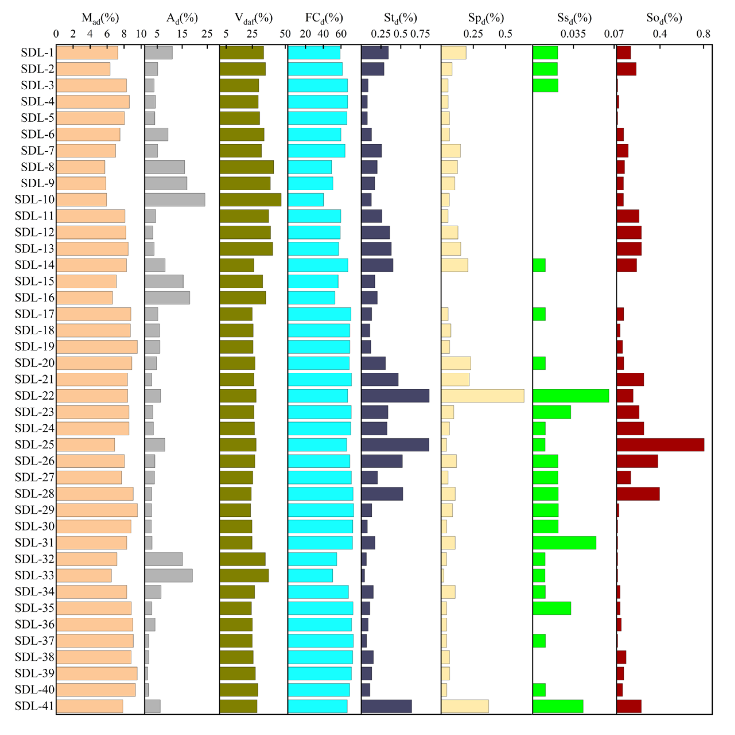
The average ash yield is 6.8% (1.24–24.1%), the average volatile matter content is 30.09% (23.65–46.93%), the average total sulfur content is 0.25% (0.04–0.86%), and the fixed carbon content is 65.37% (40.28–74.23%) (Table S1, Figure 3). According to the Chinese standard (GB15224.1-2018, GB15224.2-2021) [57,58], the No. 4 coal in the Sandaoling Mine is extra-low ash yield and extra-low sulfur coal.

4.1.2. Maceral

In No. 4 coal, the highest content of maceral is inertinite (75.18% on average) (Table S2). Inertinite is composed of semifusinite, fusinite, and a small amount of inertodetrinite. In addition, it also contains a small number of macrinite, macrinite, and trace funginite.
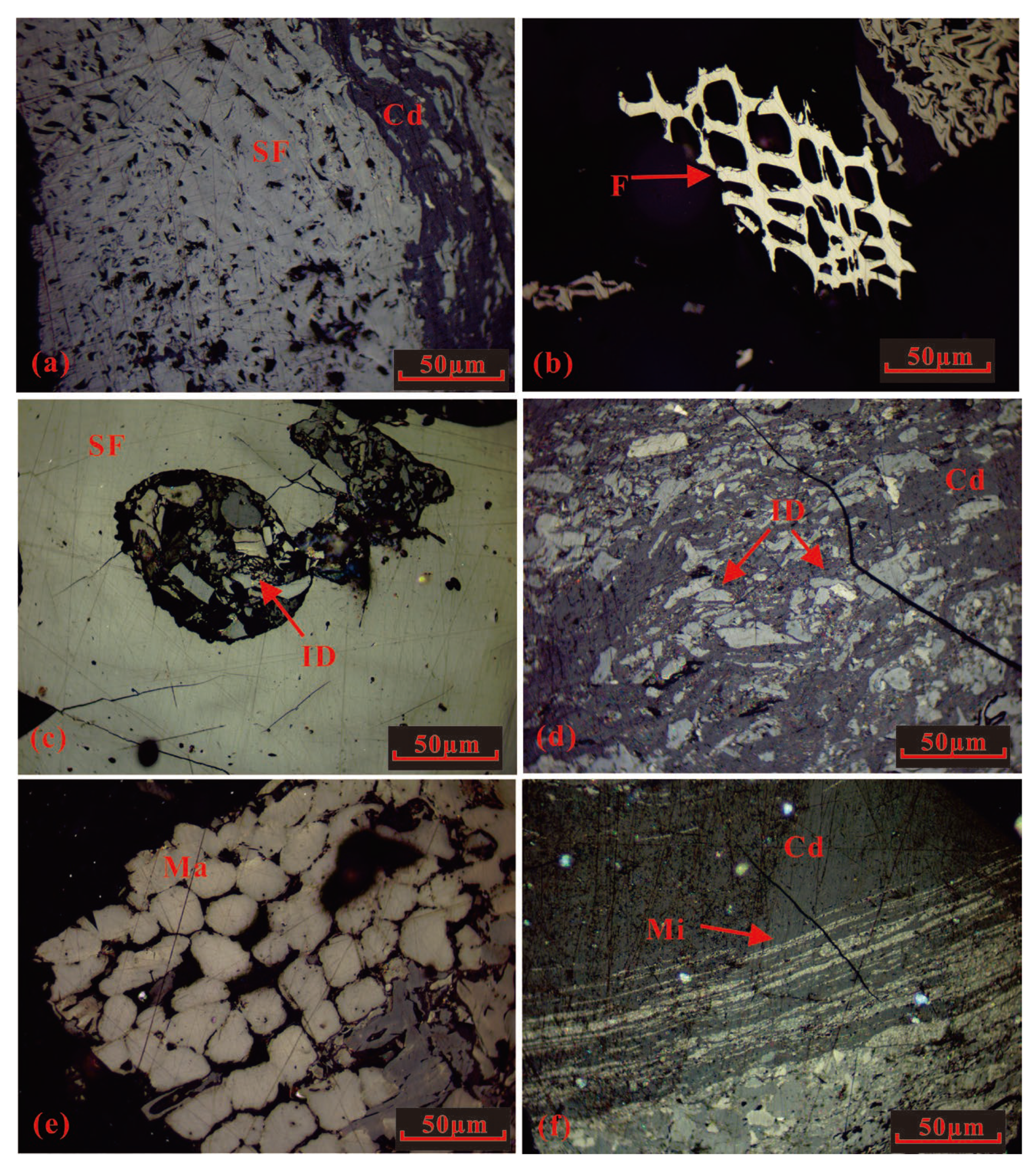
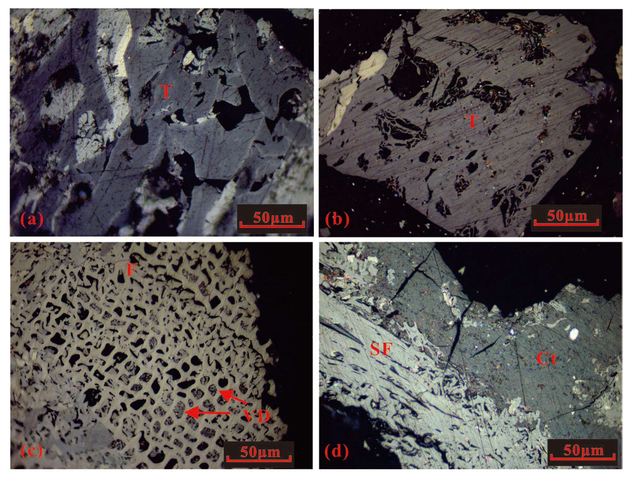
Semifusinite is the maceral with the highest content (64.02% on average) in the inertinite of No. 4 coal. The size of the semifusinite is hundreds of microns, and it has a massive and irregular structure (Figure 4a). Clay minerals and calcite exist in some semifusinite cells as the cell filling. Fusinites are mainly lumpy oxyfusinite with intact cell structure (Figure 4b), and some of the vitrodetrinite fills cells on the inside (Figure 5b). Most of the inertodetrinite particles are angular debris with varying size and color, scattered in collodetrinite (Figure 4d), and few are cell fillings. (Figure 4c). The macrinites are nearly round and irregular in shape with a uniform size, and some of them are aggregated into clusters (Figure 4e). The micrinites are mostly distributed in the collodetrinite as long strips and small debris with about several microns (Figure 4f).
Vitrinite in No. 4 coal (18.65% on average) is composed of collodetrinite and a small amount of collotelinite, vitrodetrinite, telinite, and corpogelinite.
The maceral with the highest content of vitrinite in No. 4 coal is collodetrinite (15.57% on average), most of which is a massive and irregular structure combined with semifusinite (Figure 4b) and micrinite (Figure 4f). The telinite has a patchy and crisscrossed appearance (Figure 5a), and some of the original plant cell structures are still preserved in a few massive parts of hundreds of microns (Figure 5b). The vitrodetrinite is a discrete distribution of angular fragments of several microns, which is the cell filling of the oxyfusinite (Figure 5c). Collotelinite is presented as blocks of uniform composition, and some of it is tightly bound to semifusinite (Figure 5d).
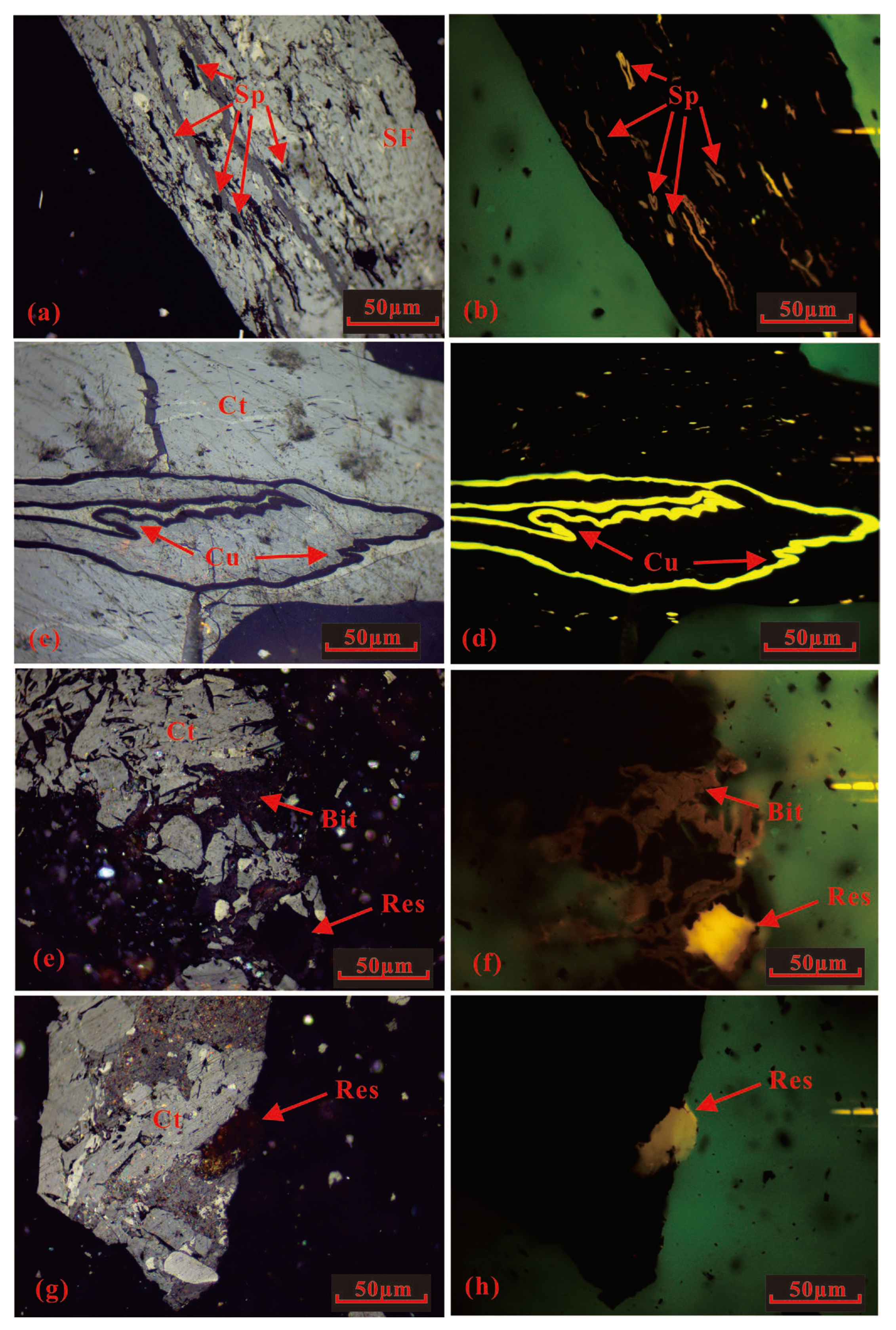
The liptinite in No. 4 coal (1.6% on average) is composed of bituminit, resinite, cutinite, and sporinite. The sporinite is principally worm-like microspores of about ten microns (Figure 6a,b). Most of the cutinite is a single strip of varying thickness, generally larger than several hundred microns in length (Figure 6c,d). The bituminits are mostly veined and dispersed with irregular shapes and uneven sizes (Figure 6e,f). Resinite is mostly round or nearly round, with a size of below 50 microns, and different internal impurities show different colors (Figure 6e,g,h).

4.2. Geochemical Features

4.2.1. Major Element Oxide (MEO)

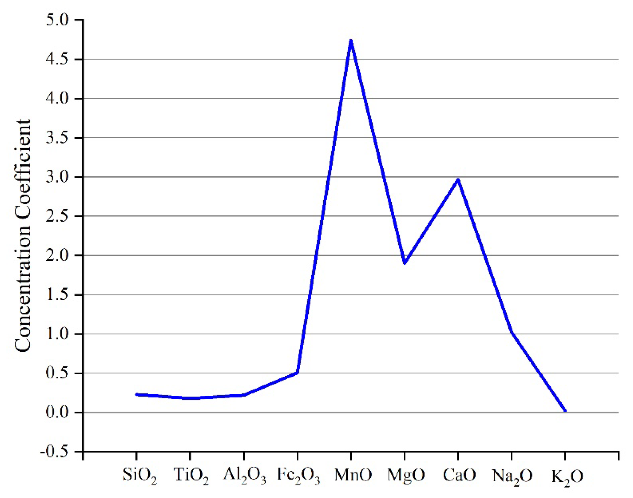
The percentage of the major oxide content in No. 4 coal is shown in Table S3 [4]. The average content of SiO2 is 1.94% (0.23–5.75%), TiO2 is 0.06% (0.03–0.11%), Al2O3 is 1.32% (0.19–2.77%), Fe2O3 is 2.45% (0.47–5.42%), MnO is 0.07% (0.01–0.19%), MgO is 0.42% (0.08–1.65%), CaO is 3.65% (0.82–8.79%), Na2O is 0.16% (0.01–1.37%), and K2O is 0.0044% (0.0013–0.0389%). The average of common Chinese coals is used to standardize the MEO in No. 4 coal, and the concentration coefficient of each MEO is obtained. It shows that MnO and CaO content is greater than the average of common Chinese coals [4], while other major element oxides have a similar or lower content (Figure 7).
The Al2O3/TiO2 value is 7.55–51.25 (22.89 on average), and the SiO2/Al2O3 value is 1.06–2.57 (1.5 on average) in No. 4 coal. The SiO2/Al2O3 is greater than the theoretical value of kaolinite (The theoretical value of SiO2/Al2O3 in kaolinite is 1.18), indicating that the coal contains a small amount of quartz [35].

4.2.2. Trace Elements

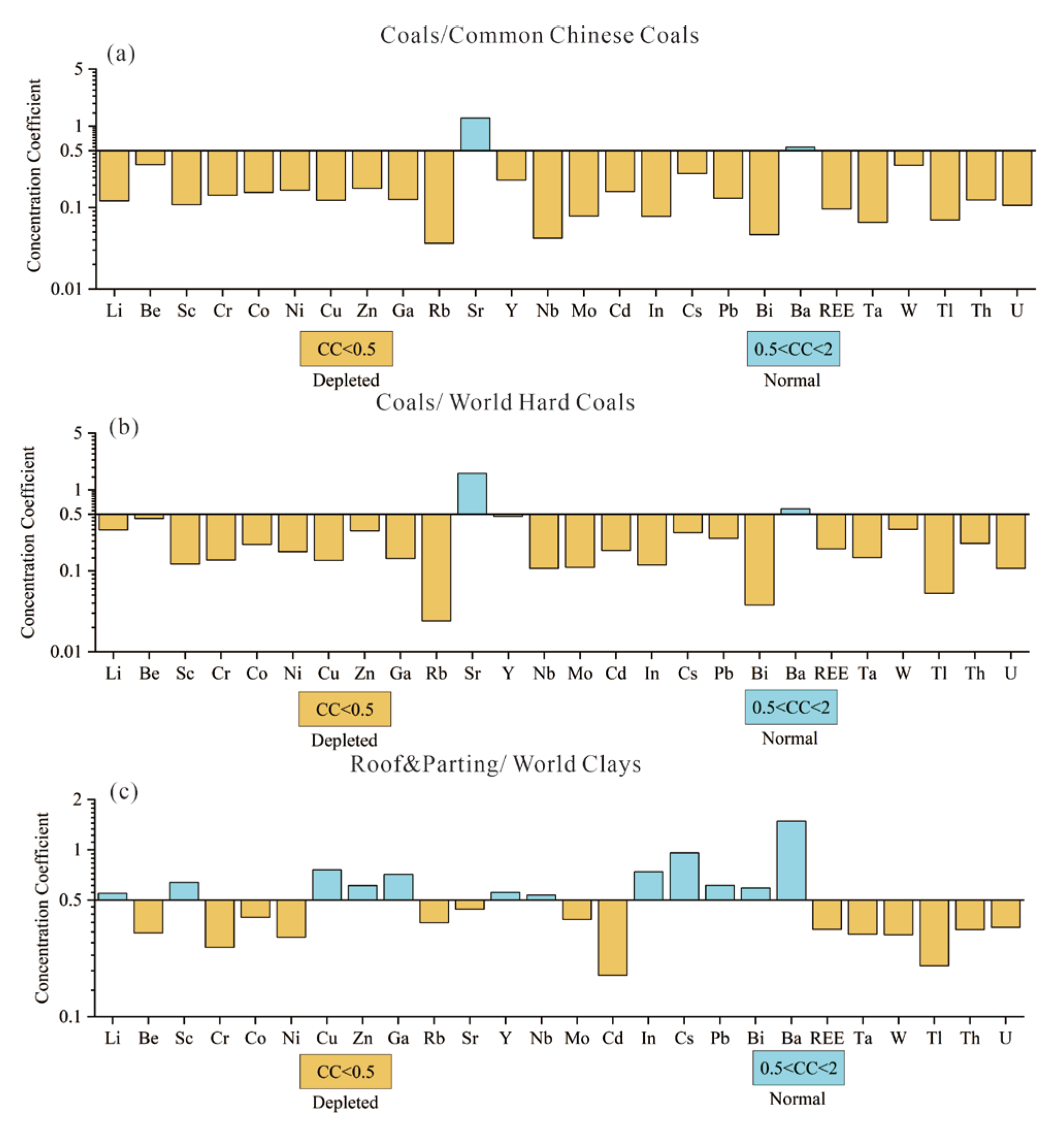
The trace elements content of No. 4 coal from the Sandaoling Mine is shown in Table S4 [4,5,59,60,61]. Only Sr (175.86, CC = 1.26) content is normal, compared with the common Chinese coals [4,5]; compared with the world hard coals [59], only Sr (175.86, CC = 1.6) and Ba (87.76, CC = 0.59) content is normal, while other elements are depleted (Figure 8a,b).
Comparison with the world clays average value of trace elements was made [60]. The contents of elements Li (29.6, CC = 0.5), Ga (11.4, CC = 0.7), Y (17.2, CC = 0.6), Cs (12.4, CC = 1), Sc (9.6, CC = 0.6), Cu (27.3, CC = 0.8), Zn (54.3, CC = 0.6), In (0.047, CC = 0.7), Pb (8.6, CC = 0.6), Nb (5.9, CC = 0.5), Bi (0.2, CC = 0.6) and Ba (682.1, CC = 1.5) in the roof and parting are normal, while others are depleted (Figure 8c).

4.2.3. Rare Earth Elements and Yttrium (REY)

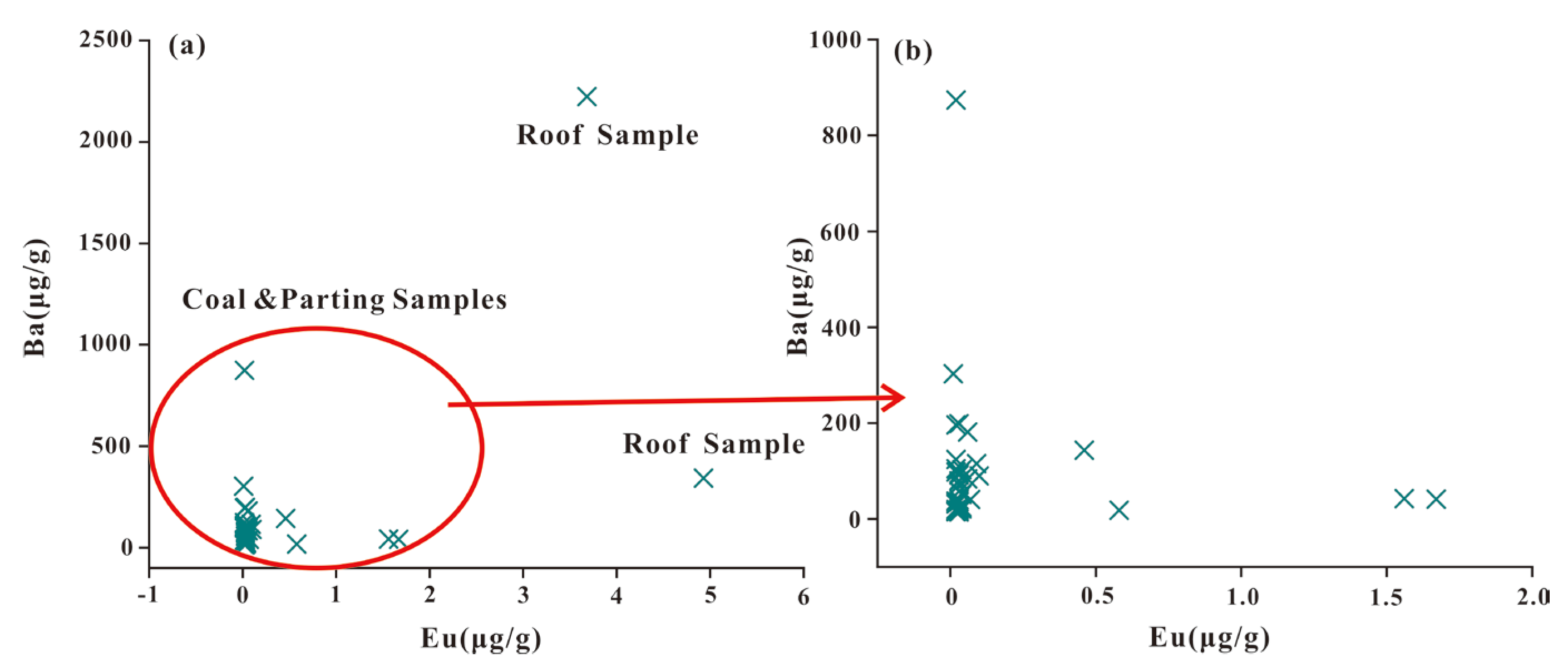
The content of rare earth elements and yttrium (REY) in No. 4 coal from the Sandaoling Mine is shown in Tables S4 and S5 [5,62,63,64,65,66,67,68,69]. The content of REY in coals is 2.89–149.35 (15.21 on average), and the content of REY in roofs and partings is 15.52–164.94 (82.57 on average). In the vertical direction, the REY content of No. 4 coal is higher near the roof and parting (SDL-1, SDL-2, and SDL-14 to SDL-18), and the REY content in the lower coal seam contacting the roof and parting separation is even greater than that of the roof and parting itself. It may be a combination of the leaching of groundwater and the adsorption of organic matter in coal [3]. The low correlation of Ba-Eu in No. 4 coal (Figure 9) indicates that the Ba content in ICP-MS has no interference with the Eu content [6,70].
In this study, Seredin’s triple classification of REY [62] and Dai’s δCe (CeN/CeN*) and δEu (EuN/EuN*) formulas [5] were used to calculate coal, roof, and parting values. Rare earth elements and Y are classified into three types: LREY, MREY, and HREY [62]. The standardization of REY adopts UCC average value [61].
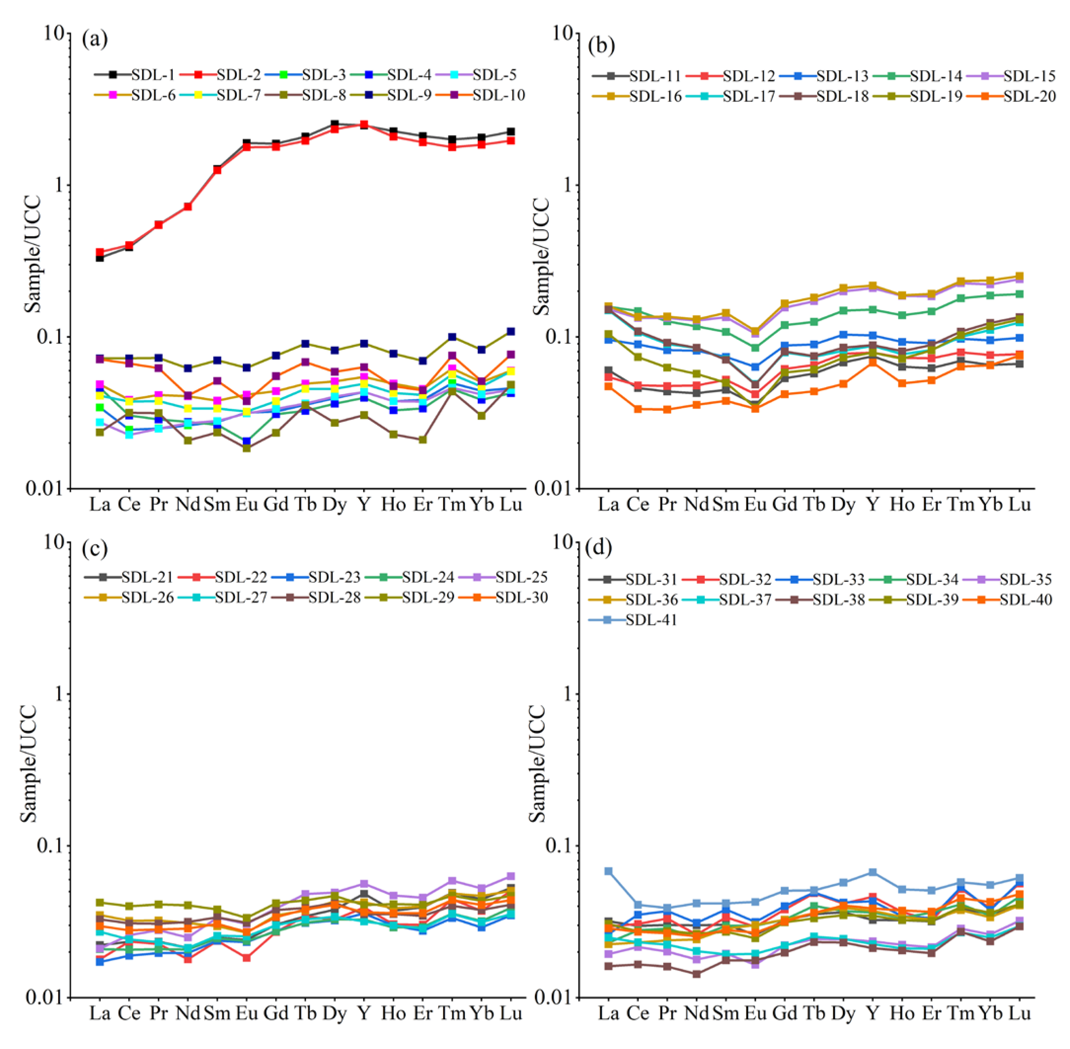
The results show that the HREY type is the most in No. 4 coal from the Sandaoling Mine (Figure 10), followed by the M-HREY type and LREY type (Table S5). The reason for the largest number of HREY types (up to 34 samples) is that HREY is able to form more stable complexes with organic matter compared with MREY and LREY [8,71].
The δEu value of No. 4 coal is 0.64–1.23 (0.84 on average). The δCe values range from 0.76–1.16 (0.96 on average). The δEu values of the roof and gangue are 0.81–1.52 (0.81 on average). δCe values range from 1.20 to 1.71 (1.51 on average) (Table S5).

4.3. Mineralogy

Minerals are another large component of coal in addition to maceral. Various geological processes in the process of coal formation will make the composition and morphology of minerals show different characteristics, indicating the formation of minerals in different environments, including the depositional environment [2,9,72]. The coal samples of No. 4 coal contain more carbonate minerals (3.83% on average) and less clays (0.45% on average), silica minerals (0.04% on average), and sulfate minerals (0.25% on average) (Table S2).
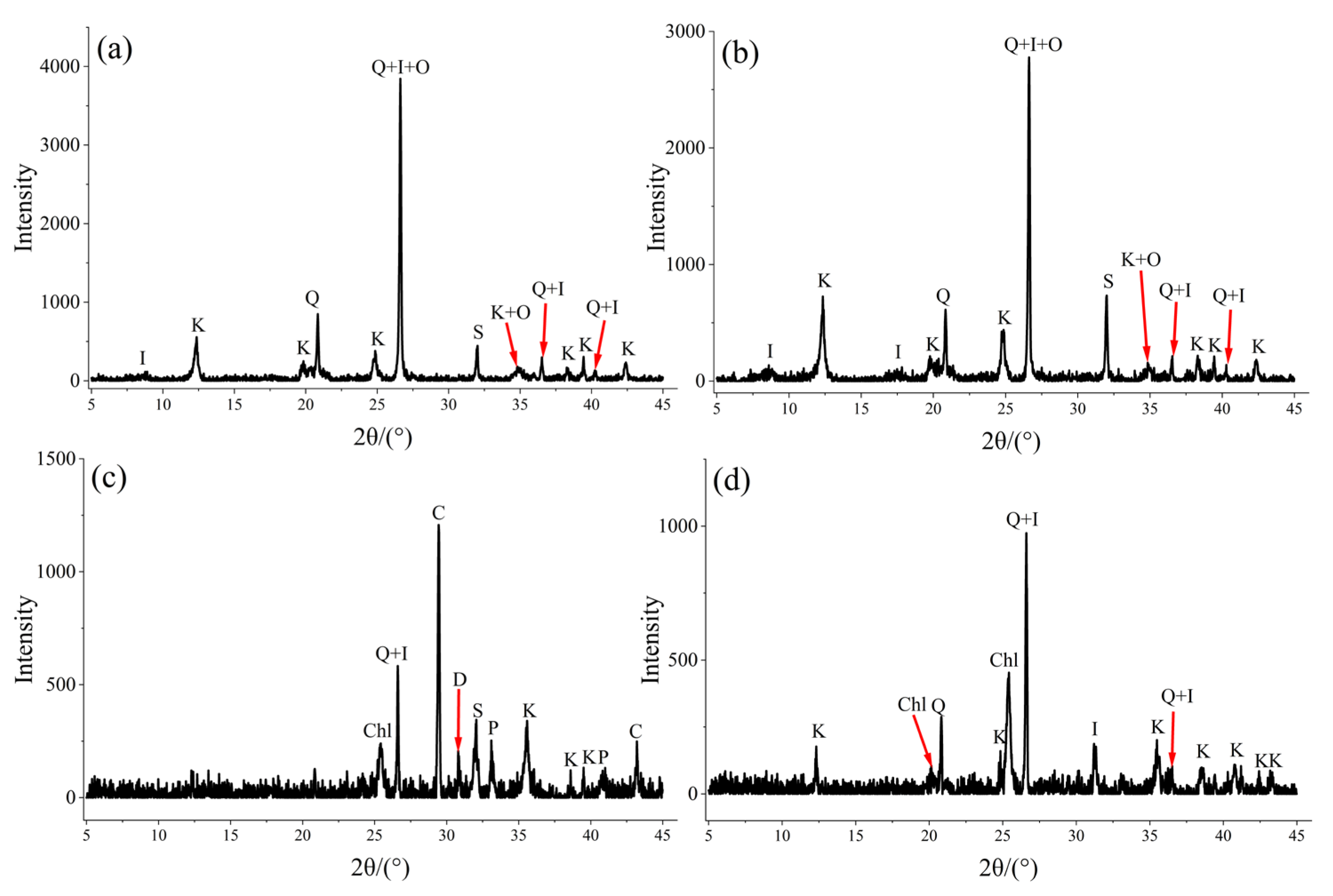
The clay minerals (42% on average) and quartz (36% on average) are the most abundant in the roof and parting and are distributed in all roof and parting samples. They are followed by calcite (9.3% on average), siderite (8% on average), dolomite (2.5% on average), orthoclase (1.8% on average), and pyrite (0.73% on average) (Table 1). Orthoclase is only distributed in the roof. The calcite, dolomite, and pyrite are only distributed in SDL-P1. The clay minerals are mainly kaolinite and illite in the roof, and kaolinite, illite, and chlorite in the parting (Figure 11).

4.3.1. Silicate Minerals

Silicate minerals are the largest and most complex minerals in coal. Silicate minerals incorporate quartz and clay minerals, of which clay minerals are the more complicated and plentiful minerals in coal, and quartz is the most frequent mineral. Clay minerals in coal may be derived from terrigenous detritus imported by early sedimentation and authigenic minerals formed by late diagenesis [2,9].
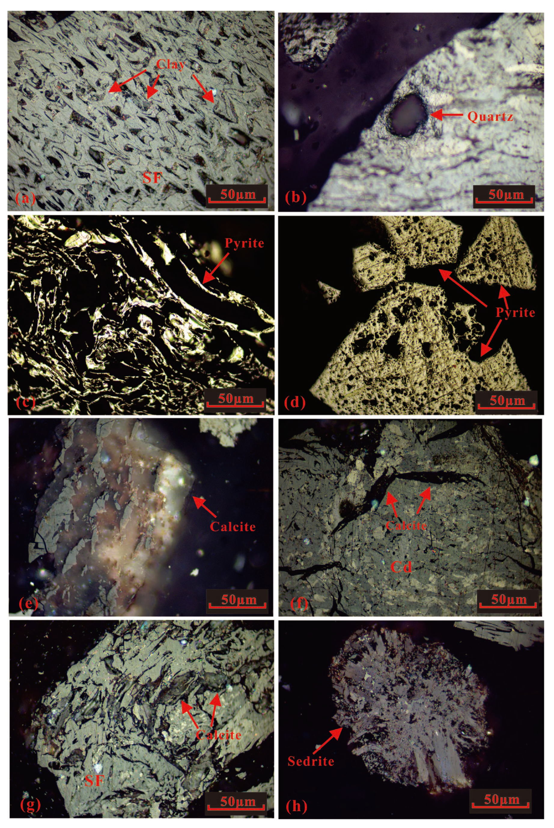
The clay minerals in No. 4 coal are almost cryptocrystalline cell fillings of semifusinite (Figure 12a); no clastic clay minerals are found, indicating that the clay minerals in No. 4 coal should be syngenetic. The quartz in the coal is allotriomorphic quartz (Figure 12b), with smooth and round edges and good roundness and a size of about tens of microns. It exists in the form of particles and is obviously formed by mechanical transport deposition, so it is inferred that the source is primary debris.

4.3.2. Pyrite

The formation of pyrite is closely related to sulfate-rich fluid in the process of coal formation [2,9,37]. The epigenetic pyrite in No. 4 coal is mostly filled in the fractures with veins (Figure 12c). Epigenetic pyrite generally represents the reactivation of organic sulfur or syngenetic sulfide in coal [73,74,75] and may also be produced after the migration of hydrothermal fluids in coal seams [2,9,76,77], so epigenetic pyrite cannot usually be used as a marker of environmental change in peat depositional environments [78].
In addition, there are a small number of euhedral pyrites showing angular shape, appearing in the form of multiple pyrite crystals of different sizes, which are syngenetic pyrites, and the voids in them indicating that pyrite has been corroded (Figure 12d).

4.3.3. Carbonate Minerals

Calcite, siderite, and dolomite series are the widespread carbonate minerals in coal. With the exception of siderite, most carbonate minerals are of epigenetic origin as fillers for fractures, cleats, and plant cell cavities in coal [73]. A small number of detrital calcite and dolomite as primary minerals indicates that the mineral source is terrigenous [2,9].
Siderite and calcite are the most important carbonate minerals in No. 4 coal, of which most calcite is cell-filling in semifusinite and vein-type fractures with different widths (Figure 12f,g), and a small part with a large size is detrital (Figure 12e). The former is epigenetic calcite, while the latter is primary calcite from terrigenous debris.
Microscopically, siderite is found to be more abundant than calcite in No. 4 coal. It is mainly siderite nodules, with a size of hundreds of microns, uneven surface color, and radial structure, which is syngenetic siderite (Figure 12h).

5. Discussion

5.1. Sediment Source

5.1.1. Al2O3/TiO2, Sr/Y, La/Yb

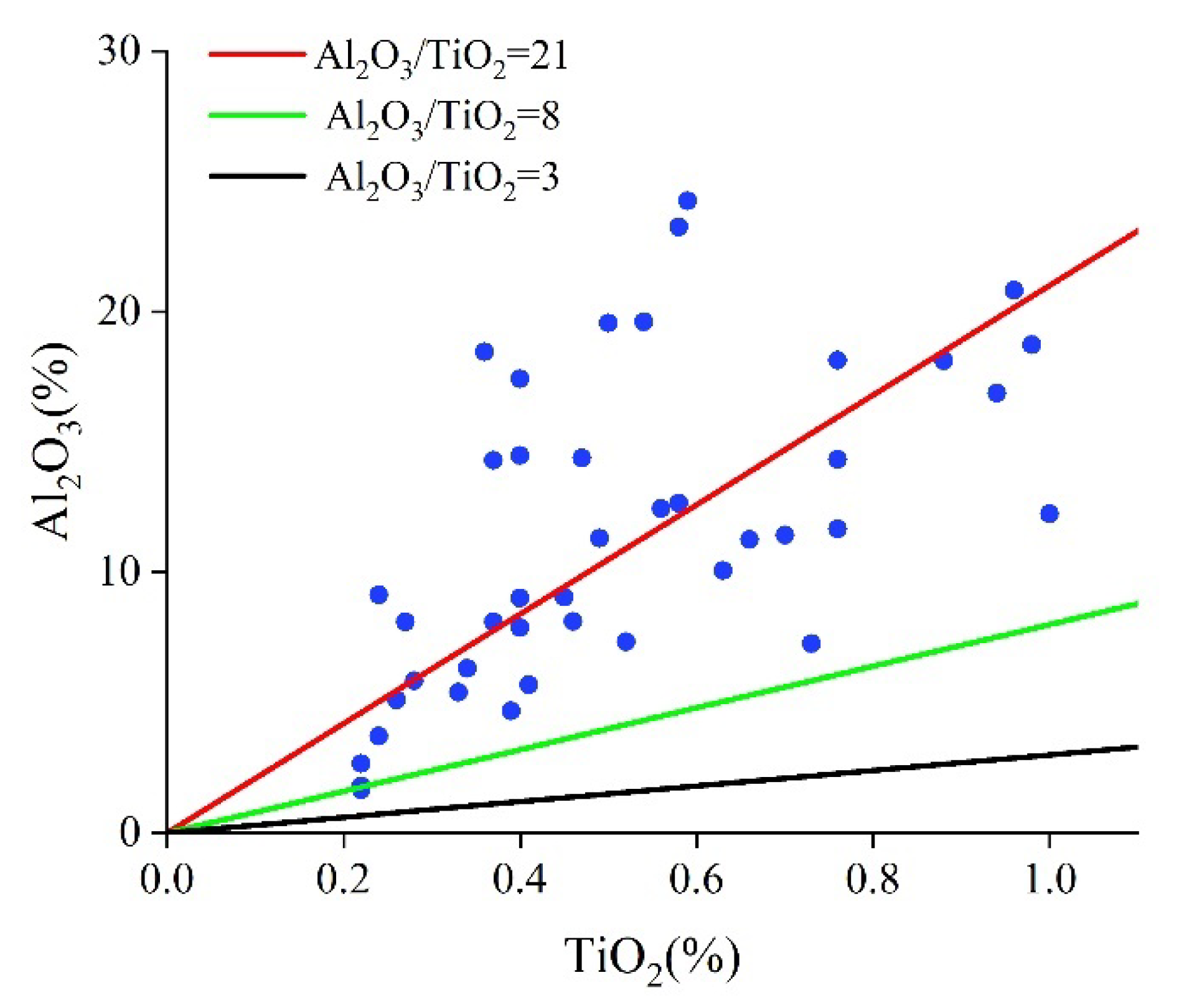
Al2O3/TiO2 ratio is appropriate for determining the source of sediments, including coal seams. Generally, when Al2O3/TiO2 > 21, the sediment source is felsic igneous rocks; when 8 < Al2O3/TiO2 < 21, the source of the sediment is intermediate igneous rocks; and when 3 < Al2O3/TiO2 < 8, the sediment source is mafic igneous rocks [41,79].
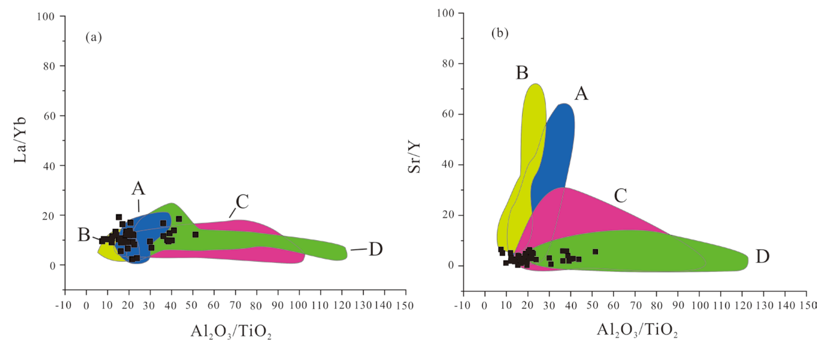
The Al2O3/TiO2 ratio in No. 4 coal in the Sandaoling Mine is 7.55–51.25 (22.89 on average), indicating that the sediments in No. 4 coal are from intermediate and felsic igneous rocks (Figure 13). In order to further study the provenance of No. 4 coal in the Sandaoling Mine, the values of Al2O3/TiO2, Sr/Y, and La/Yb between No. 4 coal and the Paleozoic igneous rocks in Harlik Mountain and Eastern Bogda Mountain are compared [41,42] (Figure 14). The results show (Figure 14) that the sediment source of No. 4 coal is the Paleozoic intermediate and felsic igneous rocks in Harlik Mountain and Eastern Bogda Mountain. The detrital sources are significantly complex, mainly granite and rhyolite with a small amount of dacite and andesite.

5.1.2. REY Distribution Patterns

Since REY often exhibit the same geochemical behavior in different geological processes, they have been widely used in the study of depositional environment and provenance [2,5,80,81,82]. δEu and δCe are the most widely used geochemical indicators.
The reduction reaction of Eu rarely occurs in the natural depositional environment. Eu is thought to be inherited from rocks in the sedimentary source area [83]. The δEu anomaly is often used to judge the type of igneous rocks in the provenance area and the influence of hydrothermal fluids [2,5,8].
Ce is a rare earth element that can stably exist in low-temperature, high-oxidation, and alkaline environment [5], mainly in the state of Ce4+. When the peat depositional environments are affected by seawater, Ce4+ is reduced to Ce3+, resulting in a negative δCe anomaly in the coal seam. At the same time, the input of terrigenous debris will also affect the δCe value. In general, δCe is less than 0.5 in oxygen-rich seawater. δCe is 0.6–0.9 in low-oxygen seawater, and 0.9–1 in anoxic seawater [2,6,80].
Almost all δEu anomalies in No. 4 coal are negative (0.84 on average), while weak positive anomalies appear in coal near the roof. The roof and parting are positive anomalies (1.12 on average).
Most of the δCe in No. 4 coal is weak negative and normal and rarely has weak positive (0.96 on average). The weak negative and weak positive of δCe in the Paleozoic intermediate and felsic igneous rocks of Harlik Mountain and Eastern Bogda Mountain indicate that the coal seam was not affected by seawater during the deposition process [2,6,80]. Positive δCe anomalies (1.51 on average) in the roof and parting may be caused by the intrusion of oxygenated groundwater as a large amount of Ce3+ was oxidized to Ce4+ and deposited in situ.
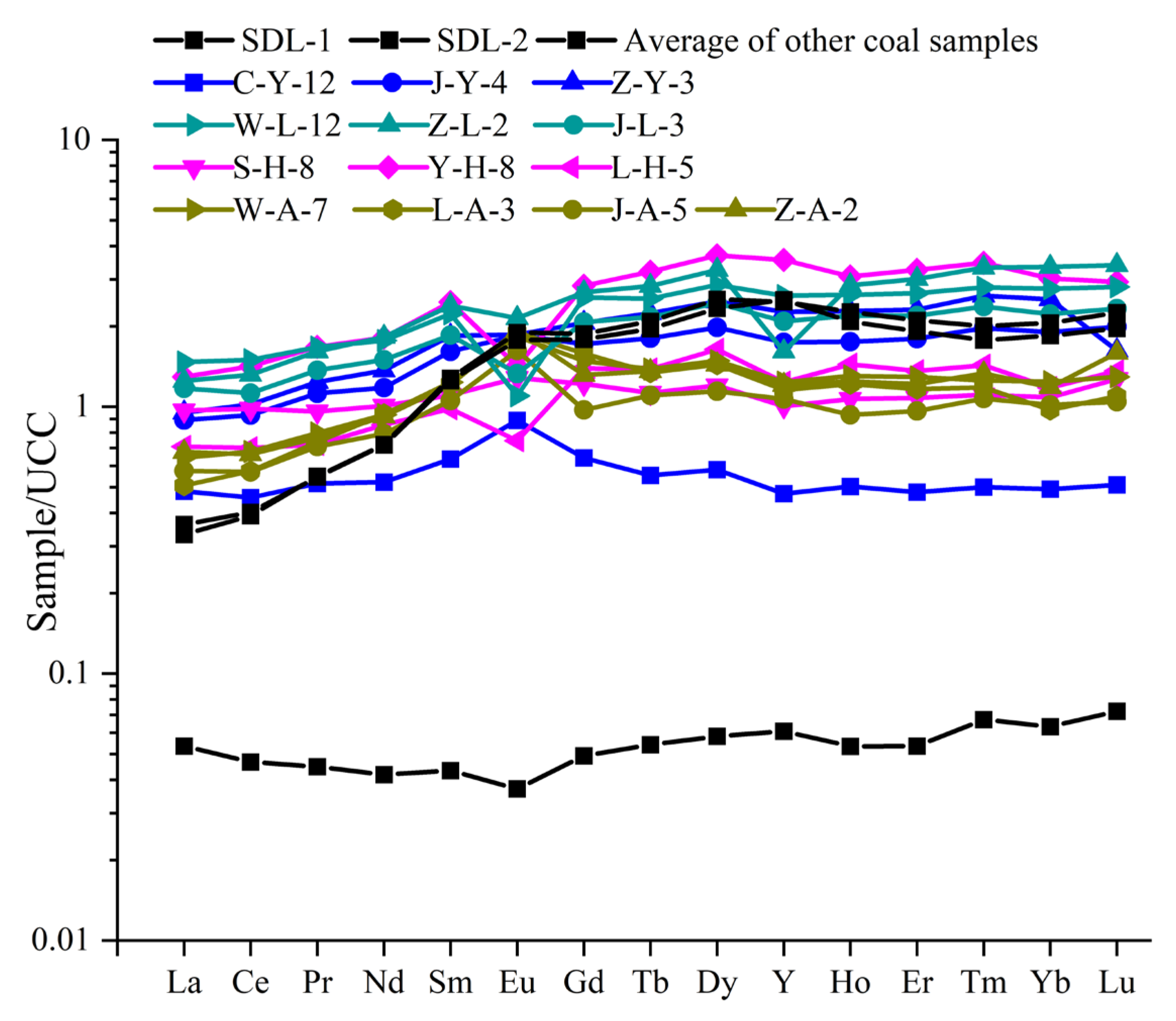
The REY distribution patterns are mostly the HREY-rich left slope type, in which SDL-1 and SDL-2 near the roof have large slopes (Figure 15), while other samples are relatively gentle (Figure 15).
The average values of REY in Carboniferous-Permian igneous rocks from Harlik Mountain and Eastern Bogda Mountain in the northeastern Turpan-Hami Basin are standardized with those of the upper crust. The δEu and δCe values of various igneous rocks (Table S5) and the REY distribution pattern (Figure 14) are calculated and plotted.
The REY distribution characteristics and δEu and δCe value anomalies of the Paleozoic igneous rocks in Harlik Mountain and Eastern Bogda Mountain were compared with those of No. 4 coal. The results show that the REY partitioning patterns of Paleozoic igneous rocks in Harlik Mountain and Eastern Bogda Mountain show the same HREY-rich left slope pattern as in No. 4 coal (Figure 15), and the rhyolite and some of the granite have negative δEu anomalies similar to those in No. 4 coal. Dacite, andesite, and some granites have positive δEu anomaly. It is speculated that the negative and weak positive anomalies of δEu in No. 4 coal may be affected by the different types of igneous rocks in the provenance area, but in general, the sediment source is still intermediate and felsic igneous rocks.
In summary, it is inferred that the provenance of No. 4 coal is mainly the Paleozoic intermediate and felsic igneous rocks in Harlik Mountain and Eastern Bogda Mountain, the northeastern Turpan-Hami Basin, which is identical to previous studies on the source of provenance debris of the Hami depression [13,15,19,22,44].

5.2. Sediment Environment

5.2.1. Syngenetic Siderite

It was found under the microscope that the syngenetic siderite is widespread in coal samples. Because the formation of siderite requires the participation of Fe2+, siderite is generally formed in a reducing environment. However, carbonate minerals are easily dissolved under acidic conditions, and the reductive and alkaline environment (pH > 7.8) will enable Mg2+ and Ca2+ to be utilized to form ankerite [2,74,84,85]. Therefore, the formation environment of syngenetic siderite is generally reductive, neutral, and weakly alkaline (7 < pH < 7.8). In addition, since the sulfate in water will combine with Fe2+ and reduce the Fe content in water, siderite is mostly formed in water with low sulfate content.
Syngenetic siderite is usually used to indicate that peat depositional environments are nonmarine environments. Only under such conditions can Fe2+ combine with CO2 dissolved in water, which is produced during the decomposition of organic matter, to form siderite [86].
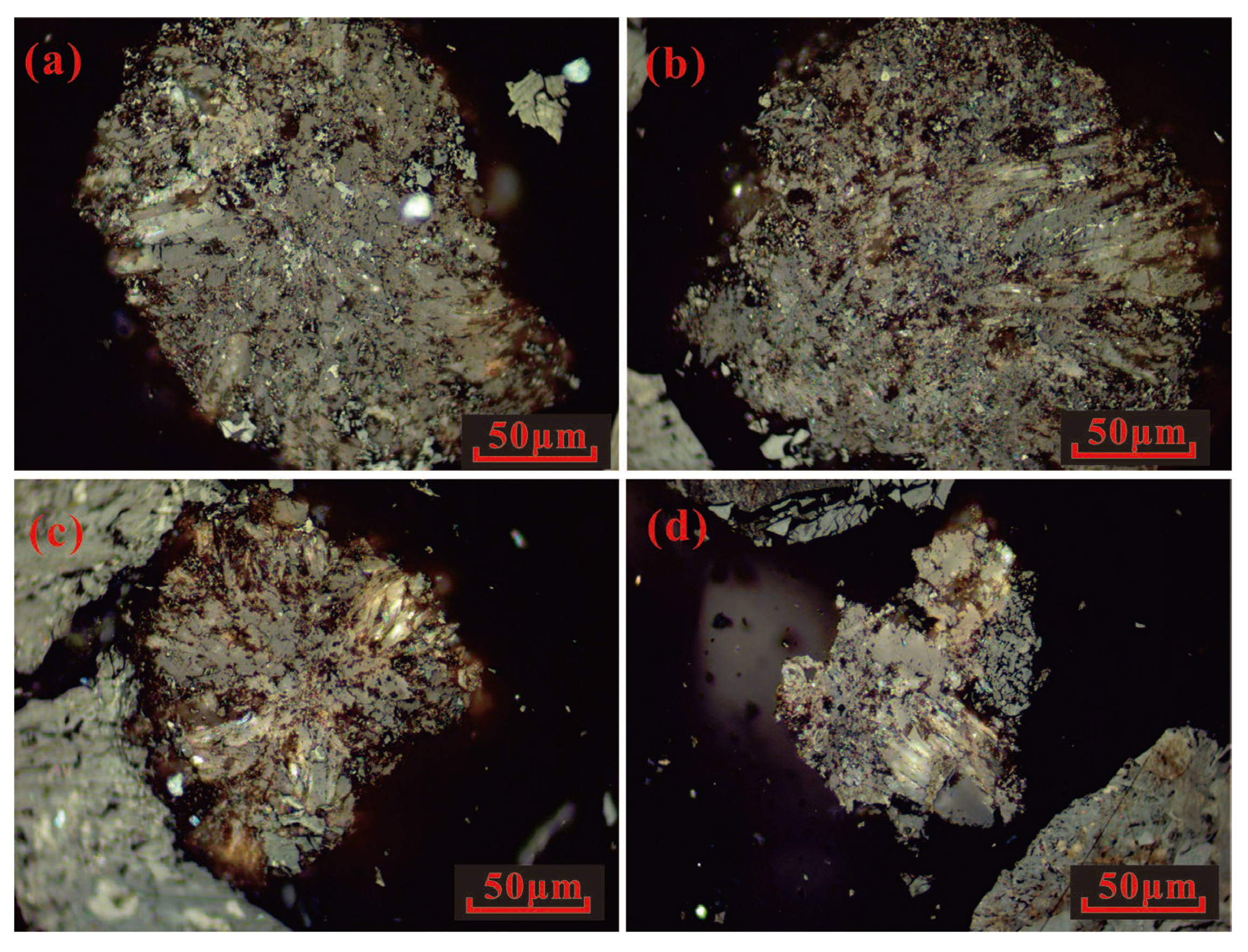
It was also found under the microscope that the nodular siderite has a radial structure (Figure 12h) and a very small amount of syngenetic pyrite (Figure 12d and Figure 16). The existence of syngenetic pyrite in coal is usually evidence of a sulfate-rich environment in peat depositional environment, such as seawater. However, if there is syngenetic siderite in coal, there must be a small amount of syngenetic pyrite [73,87]. The abundant syngenetic siderite in No. 4 coal (Figure 16) indicates that the water in the peat depositional environment is nonmarine, with neutral and weakly alkaline conditions and reductive water. Therefore, it is considered that the peat depositional environment was salt lake, which is identical to the previous studies on the paleogeographic environment evolution of the Turpan-Hami Basin [19,21].
Previous studies found that Mn2+ replaced Fe2+ in siderite and ferridolomite, and Ca2+ in calcite and ferridolomite during coal formation. This may be the reason why the content of MnO in the major oxide of No. 4 coal is greater than the average in common Chinese coals [9].

5.2.2. Maceral Indices

In this study, maceral indices are adopted to study the peat depositional environment [2,88,89,90,91,92,93,94,95,96]. The commonly used maceral indices include Gelification Index (GI), Vegetation Index (VI), Groundwater Index (GWI), Tissue Preservation Index (TPI), V/I value, F/M value, and T, D and F values [2,10,12,38,90,97,98,99,100]. Table 2 shows the calculated maceral indices of 41 coal samples in No. 4 coal and calculation formulas.
The GI and V/I values are mainly used to reflect the changes in the oxidation-reduction property, water level, and dry-humid climate in peat bogs [33,34,38,101,102]. Therefore, the higher the GI and V/I values, the higher the water level of the peat bog and the more humid the climate. On the contrary, as the water level of peat bog becomes lower, the climate gradually becomes dry. The average values of V/I and GI in No. 4 coal are both less than 1, indicating that No. 4 coal was formed under a dry environment, and the water level is relatively low (Table 2). It is only greater than 1 in SDL-13, SDL-12, and SDL-11 samples, indicating that at that time, the water level rose and the environment became humid. After this, the V/I and GI are still less than 1, but both are larger than values for the coal formed before SDL-13, indicating that the peat depositional environment is wetter than in the earlier period.
GWI is often used to reflect the control of groundwater on peat bogs, mineral content, and groundwater level change, and the lesser the GWI value is, the weaker the hydrodynamic conditions are [2,10,38,98]. TPI, VI, and F/M values also show the changes in the degree of plant tissue damage and the changes in the hydrodynamic conditions—the smaller TPI, VI, and F/M values are, the greater the degree of plant tissue damage and the stronger the hydrodynamic conditions in peat bogs are [11,100]. In the early period of No. 4 coal, TPI, VI, and F/M obviously fluctuate: GWI fluctuates slightly, and then TPI, VI, F/M, and GWI are almost stable in the later period (Table 2). This result shows that early peat bog hydrodynamic conditions changed frequently, and the hydrodynamic conditions and the degree of plant tissue damage were gradually enhanced, indicating that the climate was also changing from drought to humidity. The late hydrodynamic conditions and the degree of plant tissue damage are stable and stronger than in the early period, which is consistent with the determination of GI and V/I on the peat depositional environment.
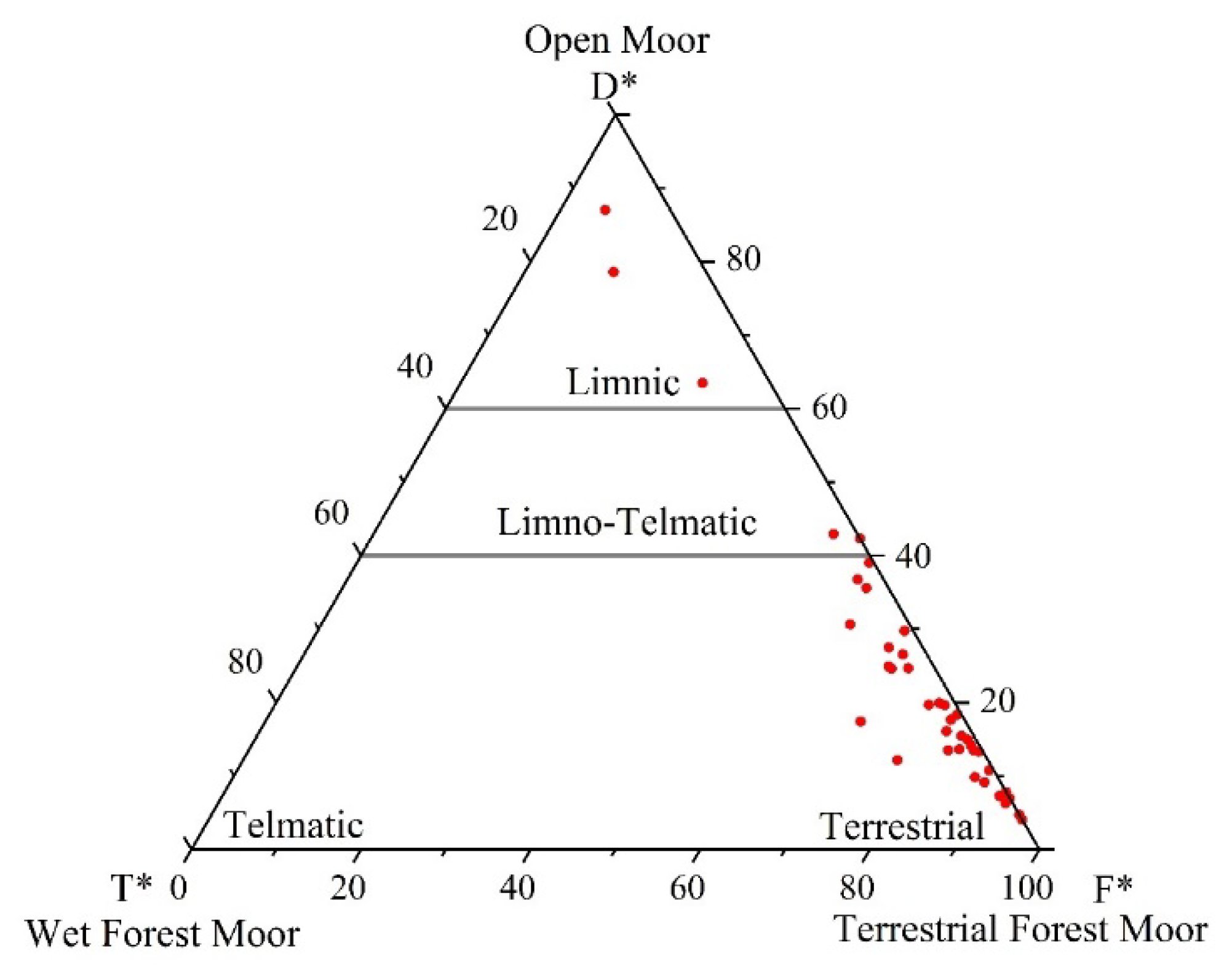
According to the T-D-F diagram, the peat sedimentary environment can be divided into open moor, wet forest moor, and terrestrial forest moor [89,97]. The respective changes in T, D, and F values can also represent the changes in climate and water in peat bogs to a certain extent. The larger the T value, the wetter the climate; the lesser the D value, the weaker the effect of lake water; the larger F value indicates that the peat bogs tend to be continental. The plot of T, D, and F of No. 4 coal (Figure 17) indicates that the peat depositional environment is mainly a terrestrial forest moor, and some coal seams in No. 4 coal are strongly affected by lake water, resulting in an anomaly with D* higher than 60 (Table 2).
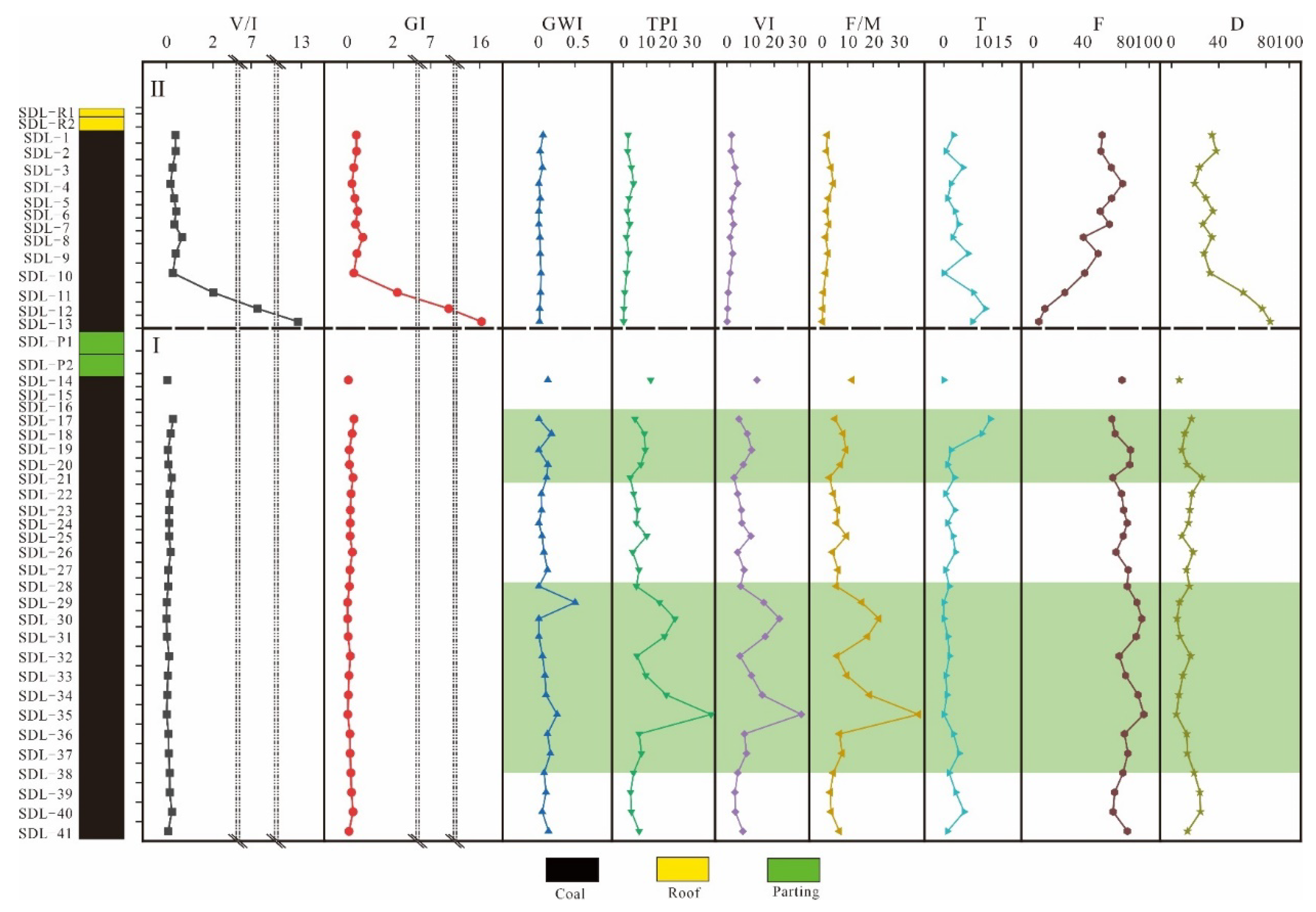
Since maceral indices cannot be used as the only indicators to determine the peat depositional environment, this study only qualitatively discusses the effects of vertical variations of the above maceral indices on the water level change, hydrodynamic conditions, degree of plant tissue damage, and the type of the peat bog [2,11,95,103,104,105]. A comparative study was conducted on the vertical variations of different maceral indices, and No. 4 coal was divided into two stages according to the indicator changes (Figure 18).
Stage I: V/I and GI are low, and TPI, GWI, VI, and F/M are high and show obvious fluctuations. Most of the T values are less than 5 and suddenly increase in the late stage, with F values above 60 and D values below 40. The results show that No. 4 coal in stage I is mainly formed in the terrestrial forest moor where periodic droughts occur on the peat surface because of alternating water level changes, which is speculated to be a dry climate. In the late stage, the climate is relatively humid, and the water level rises sharply, which leads to the reduction of the accommodating space, the interruption of peat accumulation, and the formation of parting [106]. Three peaks of TPI, VI, and F/M occur in stage I (Figure 18), representing different degrees of hydrodynamic conditions weakening, indicating that coal-forming plants may be mainly woody plants at that time or that the destruction of wood may be reduced by the weakening of humification and mineralization [100]. The three peaks of TPI, VI, and F/M values are compared with the changes in D, and it is found that when TPI, VI, and F/M increase, D usually decreases, indicating that the changes in hydrodynamic conditions and coal-forming plants in stage I are controlled by lake water.
Stage II: V/I, GI, T, and D decrease rapidly at the beginning of the stage and become stable at SDL-10 but are still higher than the corresponding values in stage I. After reaching the lowest point, F begins to rise, but it is still lower than that in stage I. TPI, GWI, VI, and F/M are all lower than those in stage I, and there is almost no fluctuation. The results show that at the beginning of stage II, the water level decreases and the peat accumulates again. However, the water level continues to decrease to the middle stage because of the dry climate, but the peat depositional environment is still more humid than that in stage I after the water level stabilizes. The hydrodynamic conditions in stage II are stable but stronger than those in stage I. The decrease in TPI, VI, F/M, and the corresponding increase in D indicate that the control of lake water over the peat bog is enhanced. Meanwhile, the influence of lake water on the hydrodynamic conditions and the degree of plant tissue damage is relatively reduced because the climate is more humid than that in stage I.

5.2.3. Sr/Ba, Th/U, Total Sulfur Content

Since Ba precipitates with sulfate faster than Sr, Ba is preferred to be lost in sulfate-rich water, resulting in relative enrichment of Sr, so the Sr/Ba ratio is widely used to judge the influence of seawater on peat depositional environment [2,56].
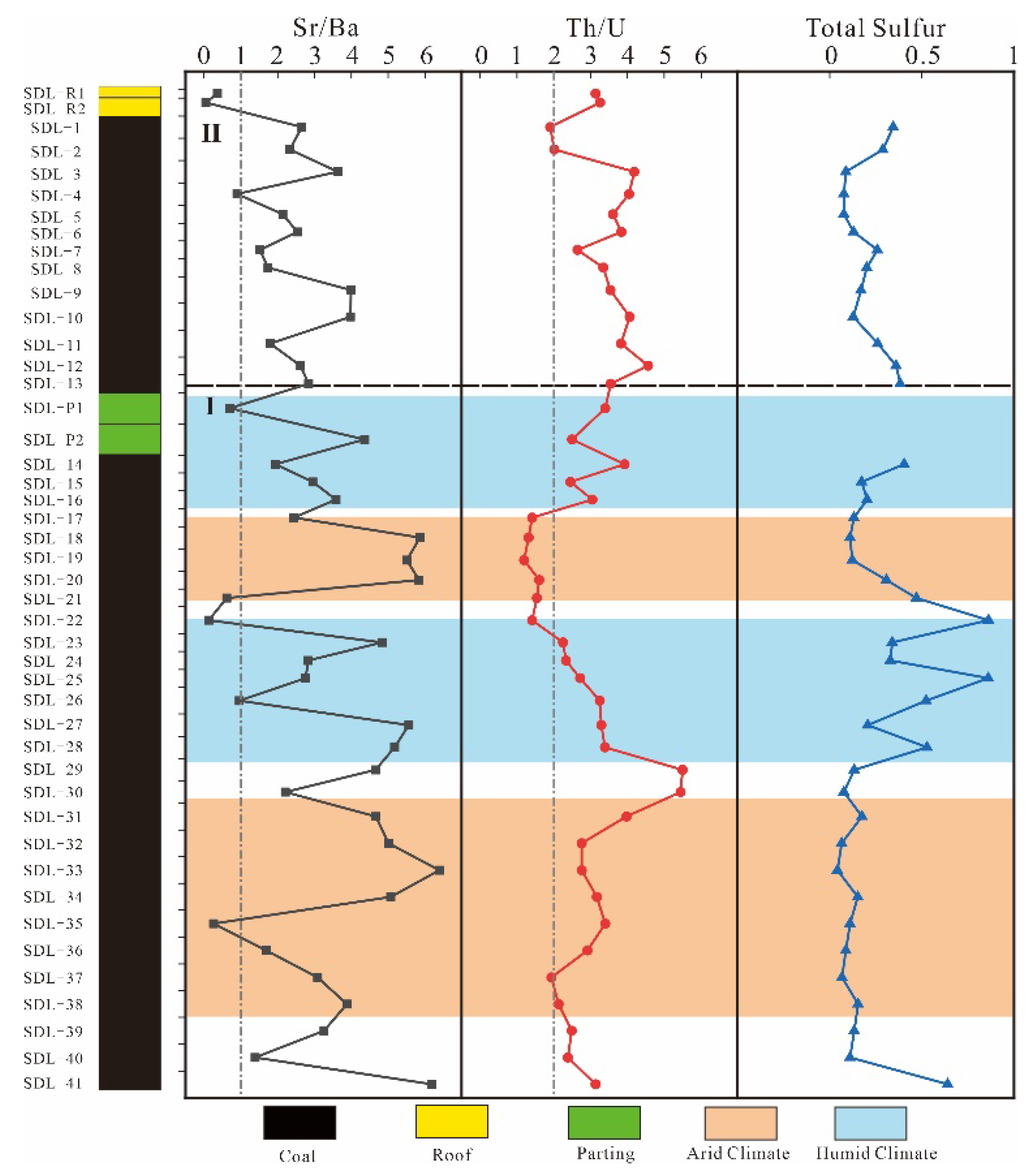
When drought persists in the inland environment, evaporation of water in the peat depositional environment is greater than the rainfall, so the salinity of water will gradually increase and more sulfate will be enriched than in fresh water environment, resulting in a higher Sr/Ba ratio [107]. Therefore, in an inland environment without seawater intrusion, a high Sr/Ba ratio can also represent a high-salinity lake water in a dry climate [39]. The Sr/Ba is generally used as an indicator to indicate the change in water salinity and its corresponding climate. If Sr/Ba is less than 1, it is the freshwater environment or a warm humid climate, and if the ratio is greater than 1, it is a salinity water environment or a hot dry climate [2,39,56,107,108,109,110].
Under hypoxic reducing conditions, soluble U6+ is usually reduced to U4+, resulting in complex precipitation. Th usually exists in the insoluble form of Th4+ and is almost unaffected at low temperatures [111,112]. The Th/U ratio <2 indicates an intensely reducing environment of anoxia; the Th/U ratio >7 indicates an intensely oxidizing environment. The Th/U ratio of 2–7 indicates the normal oxidizing environment and usually indicates the oxidation-reduction changes in the depositional environment [111,112,113].
Since the organic sulfur content in coal is lower and stable, the variation of total sulfur content is mainly affected by pyrite sulfur [2,114,115]. Pyrite is mostly formed in reducing water, but total sulfur content is extremely low in the No. 4 coal samples. Therefore, the change in total sulfur content is attributed to the change in reducing water in this study [41,116].
The Sr/Ba ratio in No. 4 coal from the Sandaoling Mine varies greatly (0.05–6.39) with an average of 3.04 (Table 2), indicating that the depositional environment is affected by seawater or high-salinity lake water. However, the very low total sulfur content in the coal (0.25% on average) rules out a possible effect of seawater on the peat depositional environment [2]. The vertical variation of the Sr/Ba ratio shows (Figure 19) that the peat depositional environment of No. 4 coal is mainly a high-salinity lake, and the Sr/Ba ratio shows a downward trend from the first to the last. At the beginning of the profile, the Sr/Ba ratio was high, up to 6.18. Then the Sr/Ba ratio began to decline continuously. It indicates that the early climate of No. 4 coal was dry and hot, and the water was mainly high-salinity lake water. As the climate gradually changed to warm and humid, the salinity of the water decreased.
The Th/U ratio in No. 4 coal is 1.2–5.5 (2.99 on average) (Table 2), and has no abnormal increase in U content in the coal seam, which leads to the decrease in the Th/U ratio. It is speculated that there may be no influence of U-rich fluid (such as seawater) on the formation of No. 4 coal [2]. The vertical variation of the Th/U ratio indicates that the overall environment is presented as a long periodical change in oxidation—reduction—oxidation (Figure 19).
The vertical variation of Sr/Ba, Th/U, and total sulfur content of No. 4 coal are compared, and the profile is divided into two stages according to the variation trends of the above three geochemical indicators (Figure 19). In this study, it is found that the variation of Sr/Ba is greater than that of Th/U and total sulfur, which may be because Sr and Ba are sensitive to the change in water salinity.
Stage I: The Sr/Ba ratio and the Th/U ratio fluctuate greatly, but the Sr/Ba ratio shows a downward trend as a whole; total sulfur content is relatively stable, with several fluctuations only in the middle period. In the early stage, the peat depositional environment changes from a reducing environment to oxidizing environment. The two peaks of the Sr/Ba ratio in the early stage are consistent with the two troughs of the Th/U ratio (Figure 19), indicating that the high-salinity lake water leads to the enhancement of reducibility and salinity, but the environment continues to change to an oxidizing environment. In the middle stage, the dramatic fluctuation of the Sr/Ba ratio and total sulfur content indicates that the climate at that time is relatively humid, and large-scale precipitation may occur several times, which reduces the salinity of water and enhances the reducibility (Figure 19). In the later period, the Sr/Ba ratio rapidly increases and decreases, the Th/U ratio gradually increases, and total sulfur content decreases and then begins to increase, indicating that the peat bog experiences a short dry climate and then gradually becomes humid. Different from the early dry and hot oxidation environment, the increase in the Th/U ratio since then represents a relatively warm and humid oxidation environment. The continuous humid climate causes the water level in the late stage to exceed the water level limit of peat accumulation, and the accommodation space decreases, leading to the interruption of peat accumulation and the formation of parting (Figure 19).
Stage II: The Sr/Ba ratio, Th/U ratio, and total sulfur content obviously fluctuate, but the Sr/Ba ratio shows an obvious downward trend, indicating that the peat depositional environment is warmer and more humid than that in stage I. The continuous humid climate causes the water salinity to decrease and the water level to rise, exceeding the limit of peat accumulation, which interrupts peat accumulation and forms the roof.

5.3. Sedimentary Evolution

In the late Paleozoic, the Paleo-Tianshan Ocean began to close and the Jueluotak Mountain rose. At that time, there was no obvious barrier between the Turpan-Hami Basin and the Junggar Basin, and the Jueluotak Mountain in the south was the main provenance area of the basin [17,19,20,22,117]. Bogda Mountain was thrust and raised by the Indosinian movement at the end of the Triassic [13,118,119]. The basement of the Turpan-Hami Basin underwent fundamental variations. With the slow uplift and intense denudation of the basin basement, the depositional range of the Turpan-Hami Basin continued to expand, and the depositional range of the basin in the Jurassic period was much larger than the current basin range [17]. Harlik Mountain and Bogda Mountain in the Jurassic were uplifted and gradually became the main provenance areas in the northern part of the basin [13,22,23,44,118,119,120]. In the early Jurassic, the Hami Depression and Turpan Depression were relatively independent. The climate in the basin changed from dry and hot to warm and humid, and experienced the first variation from peat bog to the lake, forming the first coal-bearing stratum (Badaowan Formation-Sangonghe Formation) [13,44]. The water of the Hami Depression and Turpan Depression were connected at the Middle Jurassic, and the second coal-bearing stratum (Xishanyao Formation-Sanjianfang Formation) was formed during the second variation from peat bog to the lake [13,43,44]. In the Late Jurassic, the continuous thrust of Bogda Mountain reduced the water area, and the whole Hami Depression was uplifted and the sedimentation was interrupted [18,19,20].
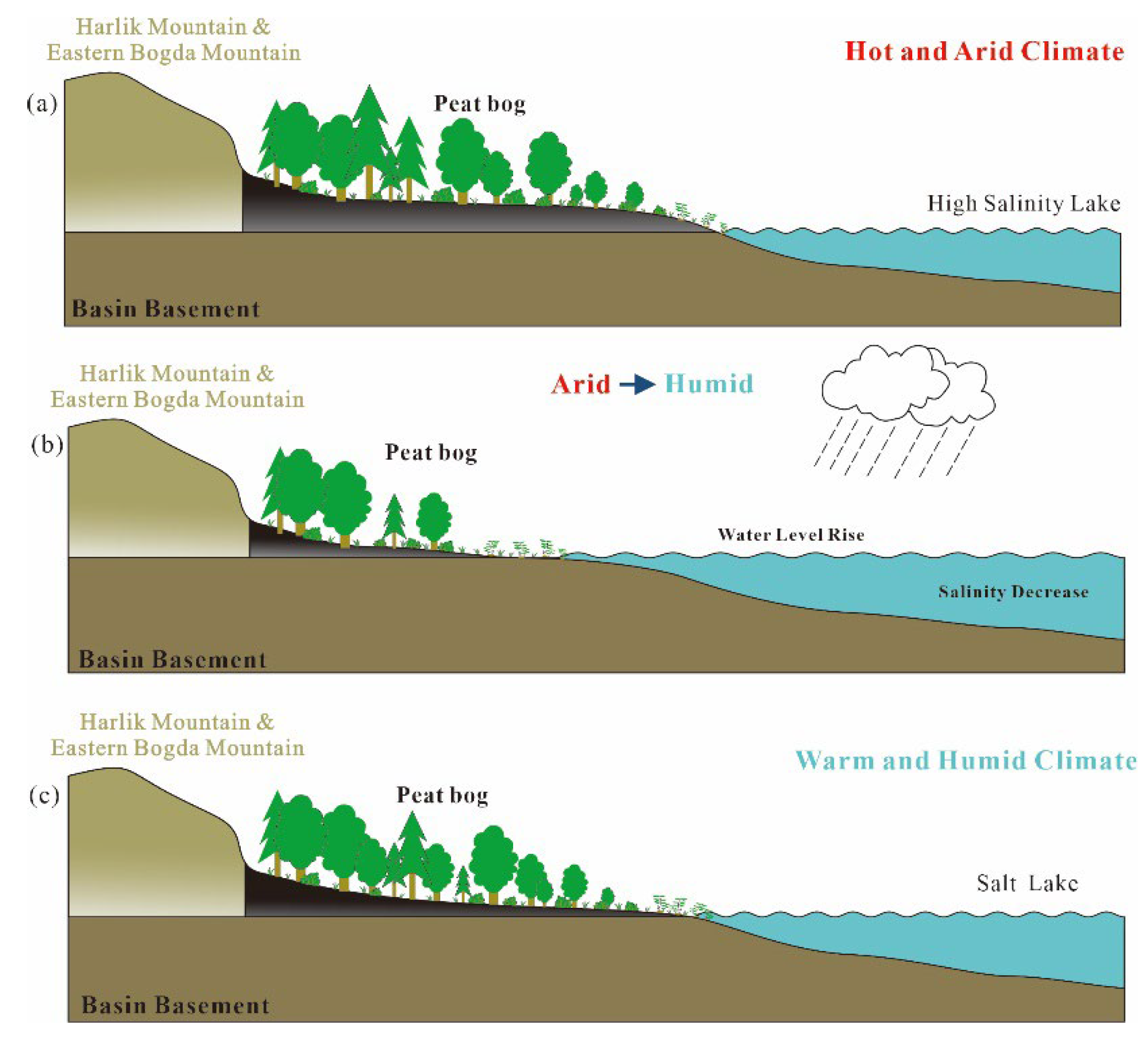
The geochemical characteristics, maceral indices, and the widely distributed syngenetic siderites of No. 4 coal of the Middle Jurassic Xishanyao Formation in the Sandaoling Mine are analyzed comprehensively, and the peat depositional environment evolution model is drawn. The provenance area of No. 4 coal is Harlik Mountain and Eastern Bogda Mountain in the northeast of the Turpan-Hami Basin. The peat depositional environment is a saltwater lake with a dry and hot climate in the early period and relatively warm and humid climate in the late period. The peat depositional environment of No. 4 coal can be segmented into two stages according to climate variation. Stage I and stage II indicate that the whole climate changed from drought to humidity, and the whole peat sedimentary environment changed from dry and hot to warm and humid (Figure 20).
In stage I, the climate was mainly dry and hot, and the vertical variations of Sr/Ba, Th/U, and total sulfur divided two climatic changes from drought to humidity (Figure 20a). In a dry climate, the peat bog was mainly controlled by salty lake water; in humid climates, fresh water interacted with salty water, but salty water tended to dominate. At the end of stage I, the continuous humid climate caused the rise of water level and the decrease in salinity and accommodation space. The parting was formed after the peat accumulation was interrupted (Figure 20b).
Influenced by the humid climate at the end of stage I, the climate of stage II was relatively warm and humid, and there was no variation (Figure 20c). Compared with stage I, the water level of the lake was higher and the salinity was lower, and the control of fresh water over the peat bog gradually became dominant. As a result, the peat accumulation was interrupted again at the end of stage II and the roof was formed (Figure 20b).

6. Conclusions

(1) No. 4 coal of the Middle Jurassic Xishanyao Formation in the Sandaoling Mine has the characteristics of low ash yield, high volatile matter, low sulfur, and high inertinite in maceral.
(2) Compared with the common Chinese coals, only Sr is normal in No. 4 coal, and other elements are depleted. In addition, the content of MnO and CaO is greater, and the content of other major element oxides is similar to or lower than that of common Chinese coals. Compared with world hard coals, only Sr and Ba are normal, while other trace elements are depleted. The contents of trace elements in the roof and parting are normal or depleted.
(3) The mineral compositions in the coal sample are mainly calcite, siderite, clay minerals, and, to a lesser degree, quartz and pyrite. The minerals in the roof and parting samples are mainly clay minerals and quartz, with smaller amounts of calcite, siderite, dolomite, orthoclase, and pyrite. Moreover, the composition of clay minerals in the roof and the parting has a subtle difference. In addition to kaolinite and illite, the parting contains a small proportion of chlorite.
(4) According to the Sr/Y, La/Yb, and Al2O3/TiO2 diagrams, the REY distribution patterns and the value of δEu and δCe prove that the sediment source of No. 4 coal is the Paleozoic intermediate and felsic igneous rocks in Harlik Mountain and Eastern Bogda Mountain in the northeastern Turpan-Hami Basin.
(5) No. 4 coal was mainly formed in the peat depositional environment that changed from a dry and hot climate to a warm and humid one. In the early period, it was formed in the dry saltwater lake environment with the dry and hot climate and the water dominated by the high-salinity lake water, and there were many changes in hydrodynamic conditions controlled by salty lake water. In the middle period, the originally dry and hot climate changed sharply to humid, the water level in the peat bog rose rapidly, the accommodation space decreased, the peat accumulation was interrupted, and the parting was formed. Later, under the continuous influence of climate change, the climate became warmer and more humid, the influence of lake water on the peat bog weakened, water salinity decreased, the water level rose, and the peat accumulation was interrupted to form the roof.

Supplementary Materials

The following supporting information can be downloaded at https://www.mdpi.com/article/10.3390/min13070837/s1, Table S1: Proximate and sulfur of No. 4 coal in the Sandaoling Mine (%); Table S2: Maceral content of No. 4 coal in the Sandaoling Mine (%, on a whole coal basis); Table S3: Content of major element oxide in No. 4 coal in the Sandaoling Mine (%, on a whole coal basis); Table S4: Content of trace elements in No. 4 coal seam in the Sandaoling Mine (μg/g, on a whole coal basis); Table S5: Content of REY in No. 4 coal, roof, and parting in the Sandaoling Mine and the igneous rocks from Harlik mountain and Eastern Bogda Mountain (μg/g, on a whole coal basic).

Author Contributions

Data curation, J.W.; formal analysis, J.W., Y.W. and G.Q.; methodology, Y.W. and G.Q.; resources, Y.W., G.Q. and S.N.; supervision, D.C. and A.W.; writing—original draft, J.W., Y.W. and G.Q. All authors have read and agreed to the published version of the manuscript.

Funding

This research was funded by the National Key Research and Development Plan of China (2021YFC2902004, 2021YFC2902005), National Natural Science Foundation of China (grant No. 41972174, 42202197, 42072197, 41902170), Science Foundation of Hebei Normal University (L2021B25).

Data Availability Statement

Data available upon request due to restrictions.

Conflicts of Interest

The authors declare no conflict of interest.

References

  1. Dai, S.; Finkelman, R.B. Coal as a promising source of critical elements: Progress and future prospects. Int. J. Coal Geol. 2018, 186, 155–164. [Google Scholar] [CrossRef]
  2. Dai, S.; Bechtel, A.; Eble, C.F.; Flores, R.M.; French, D.; Graham, I.T.; Hood, M.M.; Hower, J.C.; Korasidis, V.A.; Moore, T.A.; et al. Recognition of peat depositional environments in coal: A review. Int. J. Coal Geol. 2020, 219, 103383. [Google Scholar] [CrossRef]
  3. Dai, S.; Finkelman, R.B.; French, D.; Hower, J.C.; Graham, I.T.; Zhao, F. Modes of occurrence of elements in coal: A critical evaluation. Earth-Sci. Rev. 2021, 222, 103815. [Google Scholar] [CrossRef]
  4. Dai, S.; Ren, D.; Chou, C.-L.; Finkelman, R.B.; Seredin, V.V.; Zhou, Y. Geochemistry of trace elements in Chinese coals: A review of abundances, genetic types, impacts on human health, and industrial utilization. Int. J. Coal Geol. 2012, 94, 3–21. [Google Scholar] [CrossRef]
  5. Dai, S.; Ya, X.; Ward, C.R.; Hower, J.C.; Zhao, L.; Wang, X. Valuable elements in Chinese coals: A review. Int. Geol. Rev. 2018, 60, 590–620. [Google Scholar] [CrossRef]
  6. Dai, S.; Graham, I.T.; Ward, C.R. A review of anomalous rare earth elements and yttrium in coal. Int. J. Coal Geol. 2016, 159, 82–95. [Google Scholar] [CrossRef]
  7. Sun, B.; Zeng, F.; Moore, T.A.; Rodrigues, S.; Liu, C.; Wang, G. Geochemistry of two high-lithium content coal seams, Shanxi Province, China. Int. J. Coal Geol. 2022, 260, 104059. [Google Scholar] [CrossRef]
  8. Eskenazy, G.M. Rare earth elements in a sampled coal from the Pirin deposit, Bulgaria. Int. J. Coal Geol. 1987, 7, 301–314. [Google Scholar] [CrossRef]
  9. Finkelman, R.B.; Dai, S.; French, D. The importance of minerals in coal as the hosts of chemical elements: A review. Int. J. Coal Geol. 2019, 212, 103251. [Google Scholar] [CrossRef]
  10. Diessel, C.F.K. An appraisal of coal facies based on maceral characteristics. In Coal Resources-Origin, Exploration and Utilization in Australia; Mallett, C.W., Ed.; Australian Coal Geology: Melbourne, Australia, 1982; Volume 4, pp. 474–484. [Google Scholar]
  11. Crosdale, P.J. Coal maceral ratios as indicators of environment of deposition: Do they work for ombrogenous mires? An example from the Miocene of New Zealand. Org. Geochem. 1993, 20, 797–809. [Google Scholar] [CrossRef]
  12. Silva, M.B.; Kalkreuth, W.; Holz, M. Coal petrology of coal seams from the Leão-Butiá Coalfield, Lower Permian of the Paraná Basin, Brazil—Implications for coal facies interpretations. Int. J. Coal Geol. 2008, 73, 331–358. [Google Scholar] [CrossRef]
  13. Cao, D.; Shao, L.; Zhang, P. Palaeotectonics in The Early and Middle Jurassic Coal-Forming Periods of the Turpan-Hami Basin. J. Palaeogeogr. 1999, 2, 46–52. (In Chinese) [Google Scholar]
  14. Zhao, W.; Yuan, F.; Zeng, X. The structural characteristics of Turpan-Harmy Basin. Acta Pet. Sin. 1992, 13, 9–17, (In Chinese with English abstract). [Google Scholar]
  15. Graham, S. Sedimentary record of Mesozoic deformation and inception of the Turpan-Hami basin, northwest China. Paleoz. Mesoz. Tecton. Evol. Cent. East. Asia 2001, 194, 317. [Google Scholar]
  16. Wartes, M.A.; Carroll, A.R.; Greene, T.J. Permian sedimentary record of the Turpan-Hami basin and adjacent regions, northwest China: Constraints on postamalgamation tectonic evolution. Geol. Soc. Am. Bull. 2002, 114, 131–152. [Google Scholar] [CrossRef]
  17. Shao, L. Sedimentology and Evolution of the Turpan Basin (NW China); Institute Report of Geologic and Paleontologic Institute, Kiel University Press: Kiel, Germany, 1996; Volume 80, pp. 102–106. [Google Scholar]
  18. Shao, L.; Li, W.; Yuan, M. Characteristic of sandstone and its tectonic implications of the Turpan Basin. Acta Sedimentol. Sin. 1999, 17, 95–99. (In Chinese) [Google Scholar]
  19. Shao, L.; Zhang, P.; Hilton, J.; Gayer, R.; Wang, Y.; Zhao, C.; Luo, Z. Paleoenvironments and paleogeography of the Lower and lower Middle Jurassic coal measures in the Turpan-Hami oil-prone coal basin, northwestern China. AAPG Bull. 2003, 87, 335–355. [Google Scholar] [CrossRef]
  20. Shao, L.; Stattegger, K.; Garbe-Schoenberg, C.D. Sandstone Petrology and Geochemistry of the Turpan Basin (NW China): Implications for the Tectonic Evolution of a Continental Basin. J. Sediment. Res. 2001, 71, 37–49. [Google Scholar] [CrossRef]
  21. Ashraf, A.R.; Sun, Y.; Sun, G.; Uhl, D.; Mosbrugger, V.; Li, J.; Herrmann, M. Triassic and Jurassic palaeoclimate development in the Junggar Basin, Xinjiang, Northwest China—A review and additional lithological data. Palaeobiodiversity Palaeoenvironments 2010, 90, 187–201. [Google Scholar] [CrossRef]
  22. Shen, T.; Chen, Y.; Wang, G.; Ji, J.; Wang, Y.; Zhang, P.; Sotirious, P.; Guo, R.; Xu, Z. Detrital zircon geochronology analysis of the Late Mesozoic deposition in the Turpan-Hami basin: Implications for the uplift history of the Eastern Tian Shan, north-western China. Terra Nova 2020, 32, 166–178. [Google Scholar] [CrossRef]
  23. Qin, Y.; Liu, C.; Yang, L.; Peng, H.; Jiao, X. Detrital-Zircon Geochronology of Jurassic–Cretaceous Strata in the Turpan-Hami Basin: Implication for the Late Mesozoic Tectonic Evolution of Eastern Tien Shan. Minerals 2022, 12, 926. [Google Scholar] [CrossRef]
  24. Zhang, X.; Nie, F.; Su, X.; Li, M.; Yan, Z.; Zhang, C.; Feng, Z. Relationships between Meso-Cenozoic denudation in the Eastern Tian Shan and uranium mineralization in the Turpan-Hami basin, NW China: Constraints from apatite fission track study. Ore Geol. Rev. 2020, 127, 103820. [Google Scholar] [CrossRef]
  25. He, H.; Liang, S.; Guo, X.; Luo, Q.; Wang, J.; Chen, X.; Yang, F.; Xiao, D.; Zhang, H. New discoveries and exploration prospects of middle and Lower Jurassic lithologic reservoirs in depression area of Turpan-Hami Basin, China. Nat. Gas Geosci. 2022, 7, 265–275. [Google Scholar] [CrossRef]
  26. Hao, B.; Yang, Z.; Zhang, J.; Li, S.; Wei, L.; Shi, J.; Li, Z.; Yao, J.; Huang, X.; Wu, Q. Recognition of Petroleum Origin in the Northern Piedmont Belt of Turpan-Hami Basin and Its Significance. Geofluids 2022, 2022, 1239751. [Google Scholar] [CrossRef]
  27. Li, T.; Huang, Z.; Zhao, J.; Xu, X.; Guo, X. Pore structure characteristics and their influencing factors: A case study from the middle jurassic mixed siliciclastic carbonate rocks, Turpan-Hami basin, Northwest China. J. Pet. Sci. Eng. 2021, 203, 108611. [Google Scholar] [CrossRef]
  28. Miao, H.; Wang, Y.; Zhao, S.; Guo, J.; Ni, X.; Gong, X.; Zhang, Y.; Li, J. Geochemistry and Organic Petrology of Middle Permian Source Rocks in Taibei Sag, Turpan-Hami Basin, China: Implication for Organic Matter Enrichment. ACS Omega 2021, 6, 31578–31594. [Google Scholar] [CrossRef] [PubMed]
  29. Wu, J. Analysis of coal quality characteristics of coal seam in Sandaoling mining area. Sci. Technol. Inf. 2012, 8, 347. (In Chinese) [Google Scholar]
  30. Li, J.; Li, M.; Fan, J. Analysis on coal facies of seam in Xishanyao Formation of Sandaoling Section in Turpan-Hami Basin. Coal Sci. Technol. 2018, 46, 97–102. (In Chinese) [Google Scholar]
  31. Zhao, Y.; Deng, S.; Shang, P.; Qin, L.; Lu, Y.; Fu, G.; Ma, X. Two new species of Nilssoniopteris (Bennettitales) from the Middle Jurassic of Sandaoling, Turpan-Hami Basin, Xinjiang, NW China. J. Paleontol. 2018, 92, 525–545. [Google Scholar] [CrossRef]
  32. Li, R.; Li, X.; Wang, H.; Sun, B. Ricciopsis sandaolingensis sp. nov., a new fossil bryophyte from the Middle Jurassic Xishanyao Formation in the Turpan-Hami Basin, Xinjiang, Northwest China. Palaeontol. Electron. 2019, 22, 1. [Google Scholar] [CrossRef] [Green Version]
  33. Harvey, R.D.; Dillon, J.W. Maceral distributions in Illinois coals and their paleoenvironmental implications. Int. J. Coal Geol. 1985, 5, 141–165. [Google Scholar] [CrossRef]
  34. Teichmuller, M. The genesis of coal from the viewpoint of coal petrology. Int. J. Coal Geol. 1989, 12, 1–87. [Google Scholar] [CrossRef]
  35. Jiang, S.; Li, S.; Somerville, I.D.; Lei, J.; Yang, H. Carboniferous–Permian tectonic evolution and sedimentation of the Turpan-Hami Basin, NW China: Implications for the closure of the Paleo-Asian Ocean. J. Asian Earth Sci. 2015, 113, 644–655. [Google Scholar] [CrossRef]
  36. Zhao, L.; Ward, C.R.; French, D.; Graham, I.T. Mineralogical composition of Late Permian coal seams in the Songzao Coalfield, southwestern China. Int. J. Coal Geol. 2013, 116, 208–226. [Google Scholar] [CrossRef]
  37. Zhao, L.; Dai, S.; Nechaev, V.P.; Nechaeva, E.V.; Graham, I.T.; French, D.; Sun, J. Enrichment of critical elements (Nb-Ta-Zr-Hf-REE) within coal and host rocks from the Datanhao mine, Daqingshan Coalfield, northern China. Ore Geol. Rev. 2019, 111, 102951. [Google Scholar] [CrossRef]
  38. Dai, S.; Ren, D.; Tang, Y.; Hou, H.; Mao, H. The Evolution and Characteristic of Peat Swamp in Wuda Coalfield. J. China Coal Soc. 1998, 1, 9–13. (In Chinese) [Google Scholar]
  39. Meng, Q.; Liu, Z.; Bruch, A.A.; Liu, R.; Hu, F. Palaeoclimatic evolution during Eocene and its influence on oil shale mineralisation, Fushun basin, China. J. Asian Earth Sci. 2012, 45, 95–105. [Google Scholar] [CrossRef]
  40. Wei, Y.; He, W.; Qin, G.; Fan, M.; Cao, D. Lithium Enrichment in the No. 21 Coal of the Hebi No. 6 Mine, Anhe Coalfield, Henan Province, China. Minerals 2020, 10, 521. [Google Scholar] [CrossRef]
  41. Wei, Y.; He, W.; Qin, G.; Wang, A.; Cao, D. Mineralogy and Geochemistry of the Lower Cretaceous Coals in the Junde Mine, Hegang Coalfield, Northeastern China. Energies 2022, 15, 5078. [Google Scholar] [CrossRef]
  42. Qin, G.; Cao, D.; Wei, Y.; Wang, A.; Liu, J. Mineralogy and geochemistry of the No. 5−2 high-sulfur coal from the Dongpo Mine, Weibei Coalfield, Shaanxi, North China, with emphasis on anomalies of gallium and lithium. Minerals 2019, 9, 402. [Google Scholar] [CrossRef] [Green Version]
  43. Greene, T.J.; Carroll, A.R.; Wartes, M.; Graham, S.A.; Wooden, J. Integrated provenance analysis of a complex orogenic terrane: Mesozoic uplift of the Bogda Shan and inception of the Turpan-Hami Basin, NW China. J. Sediment. Res. 2005, 75, 251–267. [Google Scholar] [CrossRef] [Green Version]
  44. Shao, L.; Gao, D.; Luo, Z.; Zhang, P. Sequence stratigraphy and palaeogeography of the Lower and Middle Jurassic coal measures in Turpan-Hami Basin. J. Palaeogeogr. 2009, 11, 215–224. (In Chinese) [Google Scholar]
  45. ASTM Standard D2798-11a; Standard Test Method for Microscopical Determination of the Vitrinite Reflectance of Coal. ASTM International: West Conshohocken, PA, USA, 2011.
  46. International Committee for Coal and Organic Petrology (ICCP). The new vitrinite classification (ICCP System 1994). Fuel 1998, 77, 349–358. [Google Scholar] [CrossRef]
  47. International Committee for Coal and Organic Petrology (ICCP). The new inertinite classification (ICCP System 1994). Fuel 2001, 80, 459–471. [Google Scholar] [CrossRef]
  48. Pickel, W.; Kus, J.; Flores, D.; Kalaitzidis, S.; Christanis, K.; Cardott, B.J.; Misz-Kennan, M.; Rodrigues, S.; Hentschel, A.; Hamor-Vido, M.; et al. Classification of liptinite–ICCP System 1994. Int. J. Coal Geol. 2017, 169, 40–61. [Google Scholar] [CrossRef] [Green Version]
  49. ASTM Standard D3173-11; Test Method for Moisture in the Analysis Sample of Coal and Coke. ASTM International: West Conshohocken, PA, USA, 2011.
  50. ASTM Standard D3174-11; Annual Book of ASTM Standards. Test Method for Ash in the Analysis Sample of Coal and Coke. ASTM International: West Conshohocken, PA, USA, 2011.
  51. ASTM Standard D3175-11; Test Method for Volatile Matter in the Analysis Sample of Coal and Coke. ASTM International: West Conshohocken, PA, USA, 2011.
  52. ASTM Standard D3177-02; Standard Test Methods for Total Sulfur in the Analysis Sample of Coal and Coke (Withdrawn 2012). ASTM International: West Conshohocken, PA, USA, 2007.
  53. ASTM Standard D2492-02; Standard Test Method for Forms of Sulfur in Coal. ASTM International: West Conshohocken, PA, USA, 2012.
  54. Chinese National Standard SY/T 5163-2010; Standardization Administration of China; General Administration of Quality Supervision, Inspection and Quarantine of the China. Standard Press of China: Beijing, China, 2010. (In Chinese)
  55. Chung, F. Quantitative interpretation of X-ray diffraction patterns of mixtures: I. Matrix flushing method for quantitative multicomponent analysis. J. Appl. Crystallogr. 1974, 7, 519–525. [Google Scholar] [CrossRef]
  56. Dai, S.; Ji, D.; Ward, C.R.; French, D.; Hower, J.C.; Yan, X.; Wei, Q. Mississippian anthracites in Guangxi Province, southern China: Petrological, mineralogical, and rare earth element evidence for high-temperature solutions. Int. J. Coal Geol. 2018, 197, 84–114. [Google Scholar] [CrossRef]
  57. Chinese National Standard GB15224.1-2018; Standardization Administration of China; General Administration of Quality Supervision, Inspection and Quarantine of the China. Classification for Quality of Coal-Part 1: Ash. Standard Press of China: Beijing, China, 2018. (In Chinese)
  58. Chinese National Standard GB/T 15224.2-2021; Standardization Administration of China; General Administration of Quality Supervision, Inspection and Quarantine of the China. Classification for Quality of Coal-Part 2: Sulfur Content. Standard Press of China: Beijing, China, 2021. (In Chinese)
  59. Ketris, M.P.; Yudovich, Y.E. Estimations of Clarkes for Carbonaceous biolithes: World averages for trace element contents in black shales and coals. Int. J. Coal Geol. 2009, 78, 135–148. [Google Scholar] [CrossRef]
  60. Grigoriev, N.A. Chemical Element Distribution in the Upper Continental Crust; UB RAS: Ekaterinburg, Russia, 2009; Volume 382, p. 383. [Google Scholar]
  61. Taylor, S.R.; McLennan, S.M. The geochemical evolution of the continental crust. Rev. Geophys. 1995, 33, 241–265. [Google Scholar] [CrossRef]
  62. Seredin, V.V.; Dai, S. Coal deposits as potential alternative sources for lanthanides and yttrium. Int. J. Coal Geol. 2012, 94, 67–93. [Google Scholar] [CrossRef]
  63. Cui, F.; Wang, X.; Ma, Z.; Sun, J.; Zhu, X. Comparison of Genesis of Devonian Volcanic Rocks in the Bogda and Harlik Areas and its Tectonic Implications. Geol. Explor. 2015, 51, 519–533. (In Chinese) [Google Scholar]
  64. Jin, L.; Zhang, J.; Zhu, Z.; Zhao, T.; Xu, S.; Li, P.; Chen, B. The Geologic Character and Tectonic Significance of Paleozoic Volcanic Rocks in the Harlik Mountains, Xinjiang. Xinjiang Geol. 2013, 31, 173–179. (In Chinese) [Google Scholar]
  65. Zhao, T.; Xu, S.; Zhu, Z.; Liu, X.; Chen, C. Geological and Geochemical Features of Carboniferous Volcanic Rocks in Bogda-Harlik Mountains, Xinjiang and Thire Tectonic Significances. Geol. Rev. 2014, 60, 115–127. (In Chinese) [Google Scholar]
  66. Song, P.; Tong, Y.; Wang, T.; Huang, H.; Zhang, J.; Huang, W. Zircon U-Pb ages, genetic evolution and geological significance of Carboniferous granites in the Harlik Mountain, East Tianshan, Xinjiang. Geol. Bull. China 2018, 37, 790–804. (In Chinese) [Google Scholar]
  67. Yao, Y.; Xing, W.; Jia, H.; Wang, Y.; Zhao, Z.; Ma, M.; Guo, S. Geochronology, Geochemistry and Tectonic Significance of Southern Xiamaya Granite in Harlik Area, Dongtianshan Mountain. J. Mineral. Petrol. 2020, 40, 30–43. (In Chinese) [Google Scholar]
  68. Liu, B. Devonian Tectonic Evolution in Hami Area, East Tianshan: Geochemical Evidence from Igneous Rocks. Ph.D. Thesis, Lanzhou University, Lanzhou, China, 2016. (In Chinese). [Google Scholar]
  69. Wang, C.; Ma, X.; Chen, B.; Yan, X. Late Carboniferous volcanism of the Harlik orogenic belt Xinjiang: Zircon U-Pb geochronological geochemical and Sr-Nd isotopic evidence. Acta Petrol. Sin. 2017, 33, 440–454. (In Chinese) [Google Scholar]
  70. Yan, X.; Dai, S.; Graham, I.T.; He, X.; Shan, K.; Liu, X. Determination of Eu concentrations in coal, fly ash and sedimentary rocks using a cation exchange resin and inductively coupled plasma mass spectrometry (ICP-MS). Int. J. Coal Geol. 2018, 191, 152–156. [Google Scholar] [CrossRef]
  71. Eskenazy, G.M. Aspects of the geochemistry of rare earth elements in coal: An experimental approach. Int. J. Coal Geol. 1999, 38, 285–295. [Google Scholar] [CrossRef]
  72. Wang, W.; Qin, Y.; Liu, J.; Li, J. Mineral microspherules in Chinese coal and their geological and environmental significance. Int. J. Coal Geol. 2012, 94, 111–122. [Google Scholar] [CrossRef]
  73. Ward, C.R. Minerals in bituminous coals of the Sydney basin (Australia) and the Illinois basin (U.S.A.). Int. J. Coal Geol. 1989, 13, 455–479. [Google Scholar] [CrossRef]
  74. Ward, C.R. Analysis and significance of mineral matter in coal seams. Int. J. Coal Geol. 2002, 50, 135–168. [Google Scholar] [CrossRef]
  75. Spears, D. The role of seawater on the trace element geochemistry of some UK coals and a tribute to Goldschmidt. Minerals 2017, 7, 148. [Google Scholar] [CrossRef] [Green Version]
  76. Li, J.; Zhuang, X.; Querol, X.; Font, O.; Izquierdo, M.; Wang, Z. New data on mineralogy and geochemistry of high-Ge coals in the Yimin coalfield, Inner Mongolia, China. Int. J. Coal Geol. 2014, 125, 10–21. [Google Scholar] [CrossRef]
  77. Li, J.; Lin, Y.; Nguyen, X.; Zhuang, X.; Li, B.; Querol, X.; Moreno, N.; Cordoba, P. Enrichment of strategic metals in the Upper Triassic coal from the Nui Hong open-pit mine, Thai Nguyen Coalfield, NE Vietnam. Ore Geol. Rev. 2023, 153, 105301. [Google Scholar] [CrossRef]
  78. Rickard, D. Limiting conditions for synsedimentary sulfide ore formation. Econ. Geol. 1973, 68, 605–617. [Google Scholar] [CrossRef]
  79. Hayashi, K.I.; Fujisawa, H.; Holland, H.D.; Ohmoto, H. Geochemistry of ∼1.9 Ga sedimentary rocks from northeastern Labrador, Canada. Geochim. Cosmochim. Acta. 1997, 61, 4115–4137. [Google Scholar] [CrossRef] [PubMed]
  80. Murray, R.W.; Buchholtz Ten Brink, M.R.; Jones, D.L.; Gerlach, D.C.; Price Russ, G. Rare earth elements as indicators of different marine depositional environments in chert and shale. Geology 1990, 18, 268. [Google Scholar] [CrossRef]
  81. Wang, W.; Qin, Y.; Sang, S.; Zhu, Y. Geochemistry of rare earth elements in a marine influenced coal and its organic solvent extracts from the Antaibao mining district, Shanxi, China. Int. J. Coal Geol. 2008, 76, 309–317. [Google Scholar] [CrossRef]
  82. Liu, J.; Nechaev, V.P.; Dai, S.; Song, H.; Nechaeva, E.V.; Jiang, Y.; Graham, I.T.; French, D.; Yang, P.; Hower, J.C. Evidence for multiple sources for inorganic components in the Tucheng coal deposit, western Guizhou, China and the lack of critical-elements. Int. J. Coal Geol. 2020, 223, 103468. [Google Scholar] [CrossRef]
  83. Sverjensky, D.A. Europium redox equilibria in aqueous solution. Earth Planet. Sci. Lett. 1984, 64, 70–78. [Google Scholar] [CrossRef]
  84. Kortenskl, J. Carbonate minerals in Bulgarian coals with different degrees of coalification. Int. J. Coal Geol. 1992, 20, 225–242. [Google Scholar] [CrossRef]
  85. Zodrow, E.L.; Cieal, C.J. Anatomically preserved plants in siderite concretions in the shale split of the Foord Seam: Mineralogy, geochemistry, genesis (Upper Carboniferous, Canada). Int. J. Coal Geol. 1999, 41, 371–393. [Google Scholar] [CrossRef]
  86. Gould, K.W.; Smith, J.W. The genesis and isotopic composition of carbonates associated with some Permian Australian coals. Chem. Geol. 1979, 24, 137–150. [Google Scholar] [CrossRef]
  87. Li, B.; Zhuang, X.; Querol, X.; Moreno, N.; Cordoba, P.; Li, J.; Zhou, J.; Ma, X.; Liu, S.; Shangguan, Y. The mode of occurrence and origin of minerals in the Early Permian high-rank coals of the Jimunai depression, Xinjiang Uygur Autonomous Region, NW China. Int. J. Coal Geol. 2019, 205, 58–74. [Google Scholar] [CrossRef]
  88. Diessel, C.F.K. On the correlation between coal facies and depositional environments. In Proceeding of 20th Symposium of Department Geology, Newcastle, Australia, April 1986; pp. 19–22. [Google Scholar]
  89. Marchioni, D.; Kalkreuth, W. Coal facies interpretations based on lithotype and maceral variations in Lower Cretaceous (Gates Formation) coals of Western Canada. Int. J. Coal Geol. 1991, 18, 125–162. [Google Scholar] [CrossRef]
  90. Calder, J.H.; Gibling, M. Peat formation in a Westphalian B piedmont setting, Cumberland Basin, Nova Scotia: Implications for the maceral-based interpretation of rheotrophic and raised paleomires. Bull. Soc. Geol. Fr. 1991, 162, 283–298. [Google Scholar]
  91. Petersen, H.I. Petrographic facies analysis of Lower and Middle Jurassic coal seams on the island of Bornholm, Denmark. Int. J. Coal Geol. 1993, 22, 189–216. [Google Scholar] [CrossRef]
  92. Silva, M.B.; Kalkreuth, W. Petrological and geochemical characterization of Candiota coal seams, Brazil-Implication for coal facies interpretations and coal rank. Int. J. Coal Geol. 2005, 64, 217–238. [Google Scholar] [CrossRef]
  93. Singh, A.K. Petrographic characterization and evolution of the Karharbari coals, Talcher Coalfield, Orissa, India. Int. J. Coal Sci. Technol. 2016, 3, 133–147. [Google Scholar] [CrossRef] [Green Version]
  94. Zieger, L.; Littke, R. Bolsovian (Pennsylvanian) tropical peat depositional environments: The example of the Ruhr Basin, Germany. Int. J. Coal Geol. 2019, 211, 103209. [Google Scholar] [CrossRef]
  95. Sen, S.; Naskar, S.; Das, S. Discussion on the concepts in paleoenvironmental reconstruction from coal macerals and petrographic indices. Mar. Pet. Geol. 2016, 73, 371–391. [Google Scholar] [CrossRef]
  96. Jiu, B.; Huang, W.; Hao, R. A method for judging depositional environment of coal reservoir based on coal facies parameters and rare earth element parameters. J. Pet. Sci. Eng. 2021, 207, 109128. [Google Scholar] [CrossRef]
  97. Sun, Y.; Wang, B.; Lin, M. Maceral and geochemical characteristics of coal seam 1 and oil shale 1 in fault-controlled Huangxian Basin, China. Org. Geochem. 1998, 29, 583–591. [Google Scholar] [CrossRef]
  98. Dai, S.; Ren, D.; Li, S.; Zhao, L.; Zhang, Y. Coal facies succession characteristics of main coal seam in Heidaigou, Zhungeer, Inner Mongolia. Sci. China Earth Sci. 2007, 1, 119–126. (In Chinese) [Google Scholar]
  99. Guatame, C.; Rincon, M. Coal petrology analysis and implications in depositional environments from upper Cretaceous to Miocene: A study case in the Eastern Cordillera of Colombia. Int. J. Coal Sci. Technol. 2021, 8, 869–896. [Google Scholar] [CrossRef]
  100. Mangs, A.D.; Wagner, N.J.; Moroeng, O.M.; Lar, U.A. Petrographic composition of coal within the Benue Trough, Nigeria and a consideration of the paleodepositional setting. Int. J. Coal Sci. Technol. 2022, 9, 35. [Google Scholar] [CrossRef]
  101. Kalkreuth, W.D.; Marchioni, D.L.; Calder, J.H.; Lamberson, M.N.; Naylor, R.D.; Paul, J. The relationship between coal petrography and depositional environments from selected coal basins in Canada. Int. J. Coal Geol. 1991, 19, 21–76. [Google Scholar] [CrossRef]
  102. Qin, G.; Cao, D.; Wei, Y.; Wang, A.; Liu, J. Geochemical characteristics of the Permian coals in the Junger-Hebaopian mining district, northeastern Ordos Basin, China: Key role of paleopeat-forming environments in Ga-Li-REY enrichment. J. Geochem. Explor. 2020, 213, 106494. [Google Scholar] [CrossRef]
  103. Dehmer, J. Petrological and organic geochemical investigation of recent peats with known environments of deposition. Int. J. Coal Geol. 1995, 28, 111–138. [Google Scholar] [CrossRef]
  104. Diessel, C.F.K. Utility of coal petrology for sequence-stratigraphic analysis. Int. J. Coal Geol. 2007, 70, 3–34. [Google Scholar] [CrossRef]
  105. Hower, J.C.; Ruppert, L.F. Splint coals of the central appalachians: Petrographic and geochemical facies of the Peach Orchard No. 3 splint coal bed south Magoffin County Kentucky. Int. J. Coal Geol. 2011, 85, 268–275. [Google Scholar] [CrossRef]
  106. Diessel, C.F.K. On balanced and unbalanced accommodation/peat accumulation ratios in the Cretaceous coals from Gates Formation, Western Canada, and their sequence-stratigraphic significance. Int. J. Coal Geol. 2000, 43, 143–186. [Google Scholar] [CrossRef]
  107. Deng, H.; Qin, K. Geochemical binary division Character of Lacustrine Argillite. Oil Gas Geol. 1993, 2, 85–97. (In Chinese) [Google Scholar]
  108. Shi, Z.; Chen, K.; Shi, J.; Liu, B.; He, H.; Liu, G. Feasibility Analysis of the Application of the Ratio of Strontium to Barium on the Identifying Sedimentary Environment. Fault-Block Oil Gas Field. 2003, 10, 12–16. (In Chinese) [Google Scholar]
  109. Wang, M.; Jiao, Y.; Wang, Z.; Yang, Q.; Yang, S. Recovery paleosalinity in sedimentary environment—An example of mudstone in Shuixigou group, southwestern margin of Turpan-Hami basin. Xinjiang Petroleum Geol. 2005, 26, 719, (In Chinese with English abstract). [Google Scholar]
  110. Wang, A.; Wang, Z.; Liu, J.; Xu, N.; Li, H. The Sr/Ba ratio response to salinity in clastic sediments of the Yangtze River Delta. Chem. Geol. 2021, 559, 119923. [Google Scholar] [CrossRef]
  111. Jones, B.; Manning, D.A.C. Comparison of geochemical indices used for the interpretation of palaeoredox conditions in ancient mudstones. Chem. Geol. 1994, 111, 111–129. [Google Scholar] [CrossRef]
  112. Wignall, P.B.; Twitchett, R.J. Oceanic Anoxia and the End Permian Mass Extinction. Science 1996, 272, 1155–1158. [Google Scholar] [CrossRef]
  113. Adams, J.A.S.; Weaver, C.E. Thorium-to-uranium ratios as indicators of sedimentary processes: Example of concept of geochemical facies. AAPG Bull. 1958, 42, 387–430. [Google Scholar] [CrossRef]
  114. Dai, S.; Yang, J.; Ward, C.R.; Hower, J.C.; Liu, H.; Garrison, T.M.; French, D.; O’Keefe, J.M.K. Geochemical and mineralogical evidence for a coal-hosted uranium deposit in the Yili Basin, Xinjiang, Northwestern China. Ore Geol. Rev. 2015, 70, 1–30. [Google Scholar] [CrossRef]
  115. Dai, S.; Hower, J.; Finkelman, R.; Graham, I.; French, D.; Ward, C.; Eskenazy, G.; Wei, Q.; Zhao, L. Organic associations of non-mineral elements in coal: A review. Int. J. Coal Geol. 2020, 218, 103347. [Google Scholar] [CrossRef]
  116. Wei, Y.; Jia, X.; Liu, Z.; Min, L.; Hua, F.; Ning, S.; Cao, D. Study on lithology and coal quality features and coal forming environment of Yan’an Formation in Yuanyanghu Mining Area. Coal Sci. Technol. 2018, 7, 197–204. (In Chinese) [Google Scholar]
  117. Liu, D.; Jolivet, M.; Yang, W.; Zhang, Z.; Cheng, F.; Zhu, B.; Guo, Z. Latest Paleozoic–Early Mesozoic basin–range interactions in South Tian Shan (northwest China) and their tectonic significance: Constraints from detrital zircon U–Pb ages. Tectonophysics 2013, 599, 197–213. [Google Scholar] [CrossRef]
  118. Chen, K.; Lin, W.; Wang, Q. The Bogeda Shan uplifting: Evidence from multiple phases of deformation. J. Asian Earth Sci. 2015, 99, 1–12. [Google Scholar] [CrossRef]
  119. Zheng, D.; Wan, Y. Provenance of upper Permian-lowermost Triassic sandstones, Wutonggou low-order cycle, Bogda Mountains, NW China: Implications on the unroofing history of the Eastern North Tianshan Suture. J. Palaeogeogr. 2020, 9, 19. [Google Scholar] [CrossRef]
  120. Tang, W.; Zhang, Z.; Li, J.; Li, K.; Chen, Y.; Guo, Z. Late Paleozoic to Jurassic tectonic evolution of the Bogda area (northwest China): Evidence from detrital zircon U–Pb geochronology. Tectonophysics 2014, 626, 144–156. [Google Scholar] [CrossRef]
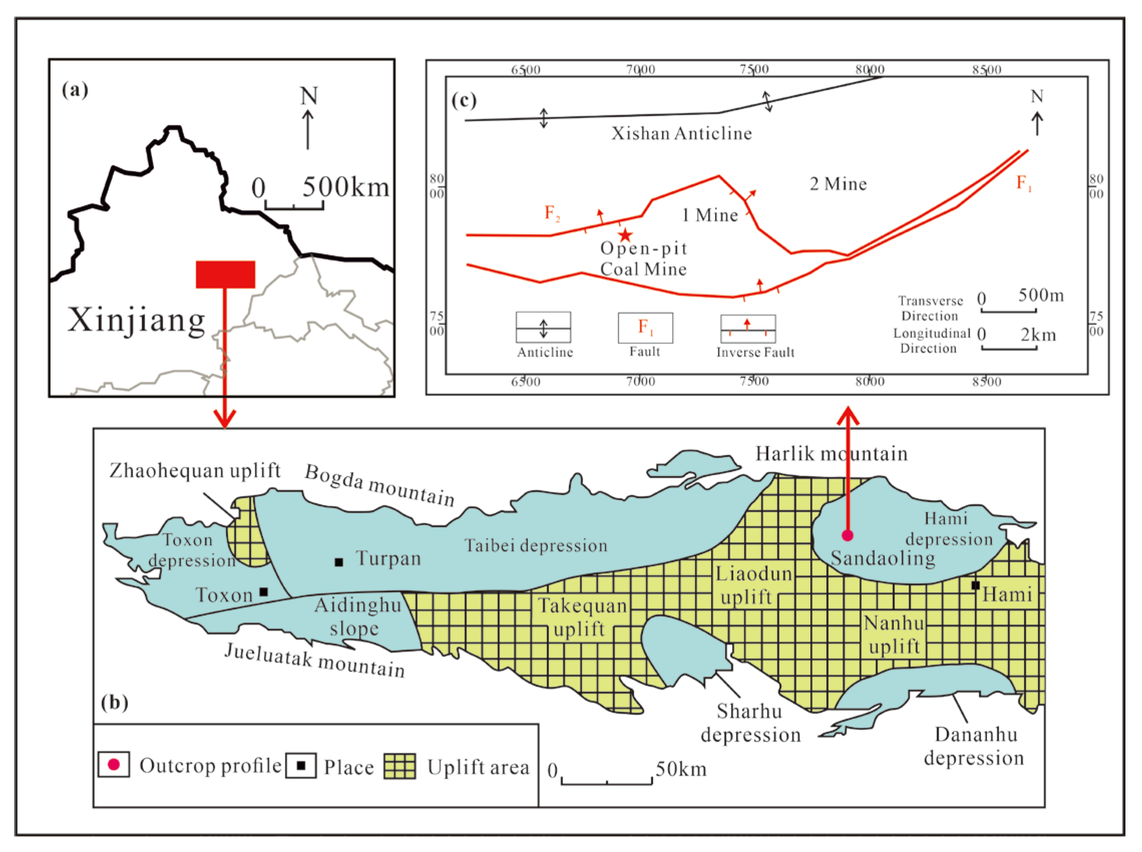
Figure 1. Location of the (a) Turpan-Hami Basin, (b) Sandaoling Mine (modified from [44]), and (c) Sandaoling open-pit coal mine.
Minerals 13 00837 g001
Figure 2. Stratum column and sampling diagram of the Sandaoling Mine.
Minerals 13 00837 g002
Figure 3. The content of proximate and sulfur of No. 4 coal in the Sandaoling Mine: M, moisture; FC, fixed carbon; A, ash yield; V, volatile matter; d, dry basis; ad, air-dry basis; daf, dry and ash-free basis; Std, total sulfur; Spd, pyritic sulfur; Ssd, sulfate sulfur; Sod, organic sulfur.
Minerals 13 00837 g003
Figure 4. Inertinite in No. 4 coal of the Sandaoling Mine (under the reflected light): (a) semifusinite and collodetrinite in SDL-2; (b) oxyfusinite in SDL-1; (c) semifusinite with cell-filling inertodetrinite in SDL-23; (d), inertodetrinite and collodetrinite in SDL-2; (e) macrinite in SDL-19; (f) micrinite and collodetrinite in SDL-27; SF, semifusinite; F, fusinite; ID, inertodetrinite; Cd, collodetrinite; Mi, micrinite; Ma, macrinite.
Minerals 13 00837 g004
Figure 5. Vitrinite in No. 4 coal from the Sandaoling Mine (under the reflected light). Telinite in SDL-5 (a) and SDL-21 (b); (c) oxyfusinite with the cell-filling vitrodetrinite in SDL-16; (d) collotelinite and semifusinite in SDL-40; VD, vitrodetrinite, T, telinite; Ct, collotelinite; SF, semifusinite; F, fusinite;.
Minerals 13 00837 g005
Figure 6. Liptinite in No. 4 coal from the Sandaoling Mine: (a) microspores and semifusinite in SDL-1 under the reflected light; (b) microspores in SDL-1 under fluorescence; (c) cutinite in SDL-6 under the reflected light; (d) cutinite in SDL-6 under fluorescence; (e) bituminit, resinite, and collotelinite in SDL-33 under the reflected light; (f) bituminit and resinite in SDL-33 under fluorescence; (g) resinite and collotelinite in SDL-32 under the reflected light; (h) resinite in SDL-32 under fluorescence. Bit, bituminite; Res, resinite; Cu, cutinite; Sp, sporinite; SF, semifusinite; Ct, collotelinite.
Minerals 13 00837 g006
Figure 7. Major element oxide concentration coefficients of No. 4 coal from the Sandaoling Mine.
Minerals 13 00837 g007
Figure 8. Trace element concentration coefficients in the Sandaoling Mine. (a) No. 4 coal/common China coals; (b) No. 4 coal/common world coals; (c), roof and parting/common world clays.
Minerals 13 00837 g008
Figure 9. Ba-Eu correlation diagram of No. 4 coal: (a) Ba-Eu correlation diagram of coal, roof, and parting samples; (b) Ba-Eu correlation diagram of coal and parting samples.
Minerals 13 00837 g009
Figure 10. The REY distribution pattern in No. 4 coal sample from the Sandaoling Mine; (a) The REY distribution pattern of SDL-1 to SDl-10; (b) The REY distribution pattern of SDL-11 to SDl-20; (c) The REY distribution pattern of SDL-21 to SDl-30; (d) The REY distribution pattern of SDL-31 to SDl-41.
Minerals 13 00837 g010
Figure 11. XRD spectrum of No. 4 coal roof and parting in the Sandaoling Mine: (a) XRD pattern of SDL-R1; (b) XRD pattern of SDL-R2; (c) XRD pattern of SDL-P1; (d) XRD pattern of SDL-P2; C, Calcite; S, Siderite; D, Dolomite; Q, Quartz; K, Kaolinite; O, Orthoclase; P, Pyrite; Chl, Chlorite; I, Illite.
Minerals 13 00837 g011
Figure 12. The minerals observed under oil immersion in No. 4 coal: (a) cell-filling clay minerals in SDL-40; (b) quartz in SDL-1; (c) vein-type pyrite in SDL-26; (d) eukaryotic pyrite particles in SDL-26; (e) detrital calcite from SDL-41; (f) vein-type calcite in SDL-27; (g) cell-filling calcite in SDL-34; (h) nodular siderite in SDL-18; SF, semifusinite; Cd, collodetrinite.
Minerals 13 00837 g012
Figure 13. Al2O3/TiO2 ratio of coal samples in No. 4 coal seam of the Sandaoling Mine.
Minerals 13 00837 g013
Figure 14. The plot of (a) La/Yb with Al2O3/TiO2, (b) Sr/Y with Al2O3/TiO2 of No. 4 coal in the Sandaoling Mine [41]: (a) La/Yb vs. Al2O3/TiO2; (b) Sr/Y vs. Al2O3/TiO2; A, Dacite, data from [63,64,65]; B, Andesite, data from [64,65,68,69]; C, Granite, data from [66,67,68]; D, Rhyolite data from [64,65,69].
Minerals 13 00837 g014
Figure 15. Distribution pattern of REY in Paleozoic igneous rocks from Harlik Mountain and Eastern Bogda Mountain; C-Y-10, J-Y-4, Z-Y-3, Dacite REY distribution pattern (data from [63,64,65]); W-L-12, Z-L-2, J-L-3, Rhyolite and Trachyte REY distribution pattern (data from [64,65,69]); S-H-8, Y-H-8, L-H-5, Granite REY distribution pattern (data from [66,67,68]); W-A-7, L-A-3, J-A-5, Z-A-2, Andesite REY distribution pattern (data from [64,65,68,69]).
Minerals 13 00837 g015
Figure 16. Syngenetic siderite in No. 4 coal from the Sandaoling Mine: (a) syngenetic siderite in SDL-26; (b) syngenetic siderite in SDL-27; (c) syngenetic siderite in SDL-36; (d) syngenetic siderite in SDL-41.
Minerals 13 00837 g016
Figure 17. The plot of T, D, and F of the No. 4 Coal: D* = D/(D + T + F) × 100 [97]; T* = T/(D + T + F) × 100 [97]; F* = F/(D + T + F) × 100 [97].
Minerals 13 00837 g017
Figure 18. Vertical variation of coal facies indices of No. 4 coal seam in the Sandaoling Mine.
Minerals 13 00837 g018
Figure 19. Vertical variation of Sr/Ba, Th/U, total sulfur in No. 4 coal of the Sandaoling Mine.
Minerals 13 00837 g019
Figure 20. Peat depositional environment evolution model of No. 4 coal in the Sandaoling Mine: (a) stage I Peat depositional environment; (b) evolution of peat depositional environment; (c) stage II peat depositional environment.
Minerals 13 00837 g020
Table 1. XRD quantitative analysis of No. 4 coal roof and parting in the Sandaoling Mine (%, on a mineral basis).
SampleQuartzOrthoclaseCalciteDolomiteSideritePyriteTCCM
SDL-R152.04.0--5.0-39.0
SDL-R246.03.0--15.0-36.0
SDL-P114.0-37.010.012.02.025.0
SDL-P232.0-----68.0
Average36.01.759.32.58.00.542.0
Notes: TCCM, total content of clay minerals; -, not detected or no data.
Table 2. Sr/Ba, Th/U, total sulfur, and coal facies indices of No. 4 coal seam in the Sandaoling Mine.
SampleSr/BaTh/UTotal SulfurV/IGITPIGWIVIF/MTFD
SDL-R10.363.14----------
SDL-R20.053.26----------
SDL-12.651.910.350.390.392.020.061.982.022.5359.6034.34
SDL-22.332.020.290.410.411.840.021.811.840.5258.5537.82
SDL-33.644.190.090.270.293.500.053.423.504.9367.4923.65
SDL-40.904.040.080.190.204.440.004.554.441.8377.1719.63
SDL-52.143.610.080.340.342.540.022.542.541.0167.8429.15
SDL-62.543.830.130.430.451.800.001.801.802.9457.8435.29
SDL-71.522.650.260.340.362.740.002.792.743.8565.8726.44
SDL-81.743.350.200.680.681.360.011.361.362.2643.4434.39
SDL-93.993.540.170.400.432.350.022.432.356.2856.0427.54
SDL-103.984.060.130.280.281.410.031.411.410.0044.5532.67
SDL-111.803.830.262.002.190.580.020.590.587.6127.4160.91
SDL-122.624.560.367.277.790.280.010.280.2810.6910.3077.03
SDL-132.843.550.3812.8716.080.150.010.150.157.415.0983.80
SDL-P10.703.40----------
SDL-P24.362.50----------
SDL-141.943.930.400.050.0511.790.1312.6911.790.0076.746.51
SDL-152.952.460.17---------
SDL-163.593.050.20---------
SDL-172.441.410.130.290.295.070.005.075.0711.9667.9316.85
SDL-185.861.320.110.200.219.110.178.658.249.7770.7011.16
SDL-195.501.200.120.070.089.450.0010.509.451.8284.098.64
SDL-205.841.610.310.100.107.520.136.927.210.9883.4113.17
SDL-210.621.550.470.230.252.980.113.042.922.7668.6625.81
SDL-220.131.410.860.160.174.450.044.574.450.4576.3617.27
SDL-234.832.260.340.120.136.150.046.156.152.7978.0915.54
SDL-242.832.330.330.120.145.700.006.335.700.9681.2514.42
SDL-252.762.710.860.120.1210.100.0510.109.622.3877.788.73
SDL-260.963.250.520.190.234.080.074.584.082.9671.4318.23
SDL-275.563.300.210.100.126.750.127.276.300.4482.1012.66
SDL-285.173.390.530.090.105.650.005.835.651.4281.1315.09
SDL-294.655.500.130.020.0215.580.5015.5815.580.0089.476.70
SDL-302.215.440.080.010.0222.300.0022.3022.300.0093.704.62
SDL-314.663.970.170.040.0417.800.0016.2017.801.0188.897.07
SDL-325.012.760.060.120.135.920.055.505.921.4874.3816.26
SDL-336.392.760.040.070.089.760.0810.389.760.4879.719.66
SDL-345.073.170.150.050.0518.580.1014.9418.580.8290.576.12
SDL-350.263.400.110.020.0237.800.2531.5037.800.0095.454.04
SDL-361.682.920.090.100.116.880.127.506.882.4678.8212.81
SDL-373.081.940.070.110.127.860.168.247.863.9681.6813.37
SDL-383.882.130.150.140.164.400.074.634.401.3577.5819.28
SDL-393.262.490.130.160.193.170.103.433.173.0670.3124.02
SDL-401.392.380.110.250.253.520.053.603.525.2668.8624.56
SDL-416.183.130.640.080.086.810.136.816.810.9381.4013.49
Average3.042.990.250.740.857.030.076.866.972.8569.5322.28
Notes: -, not detected or no data; GI = (V + Ma)/(F + SF + ID) [10,88]; TPI = (T + CT + F + SF)/(CD + Ma + ID) [10,88]; T = T + CT [89]; F = F + SF [89]; D = VD + CD + Sp + Ed + Cu + Res + ID + Clays + Silica Minerals [89]; GWI = (CG + VD + Clays)/(T + CT + CD) [90]; VI = (T + CT + F + SF)/(CD + VD + ID + Cu) [90]; F/M = (T + CT + F + SF)/(VD + ID + Ma + CD) [89].
Disclaimer/Publisher’s Note: The statements, opinions and data contained in all publications are solely those of the individual author(s) and contributor(s) and not of MDPI and/or the editor(s). MDPI and/or the editor(s) disclaim responsibility for any injury to people or property resulting from any ideas, methods, instructions or products referred to in the content.