Abstract
Sandstone type uranium is the most valuable and has the most potential for mining among the known uranium deposits. In the process of forming, the hydrolytic migration and enrichment of uranium require special basin sedimentary environment and tectonic background. Therefore, the mineralization process of sandstone type uranium deposits has certain layering characteristics and distribution rules in the underground vertical depth space. It is important to mine the spatial distribution characteristics of vertical uranium-bearing layers, and thus, reconstruct the three-dimensions of uranium orebodies. In this paper, according to the metallogenic law and distribution characteristics of sandstone type uranium in the underground vertical space, a nonlinear uranium-bearing layers identification (NULI) method of sandstone type uranium is proposed by using different types, resolutions and scales of borehole data. Then, the depth of uranium mineralization for the Daying uranium deposit within northern Ordos Basin is identified accurately and the spatial distribution characteristics of the uranium-bearing layer on the exploration line are obtained. Finally, the occurrence mode of the underground uranium orebodies are presented by using three-dimensional reconstruction analysis. It provides a basis for the prediction, exploration and mining of sandstone type uranium deposits within the Ordos Basin.
1. Introduction
Uranium is a strategic resource closely related to national security and economic development. Uranium resources are an important guarantee for the sustainable development of nuclear energy and national defense construction in China. As a clean and stable base load energy, uranium resources are an important choice to achieve carbon neutrality, which can ensure sustainable economic development and ecological civilization construction in China. Sandstone type uranium deposit is the most promising and valuable type of uranium deposit. It may have been discovered in the Ordos Basin, Erlian Basin, Ili Basin, and in the Songliao Basin, in China, and some have already reached the scale of large/ultra-large mineral deposits [1]. Sandstone type uranium deposit play an important role in the supply of uranium resources in China. They are characterized by shallow depth, large-scale reserves and low cost of mining [2,3]. At present, there are a series of studies on the geological conditions, mechanisms, and basin characteristics of sandstone type uranium deposits [4,5]. However, the deep prediction on its mineralization model and ore body size are in the exploratory stage [6]. Therefore, further research is needed for the exploration and prediction of sandstone type uranium deposits.
Ordos Basin, as an important treasure trove of uranium resources in China, is located in the northern part of the North China Craton [7,8,9]. Large or supersized sandstone type uranium deposits, such as Zaohuahao, Nalinggou, Hantai Temple, Daying, Bayinqinggeli and Dongsheng, have already been discovered in the northern part of the basin [10]. It is the milestone transformation in uranium exploration and mining research, and provided a foundation and driving force for sustainable development in China [11,12]. The Daying uranium deposit is one of the important areas for uranium exploration. Industrialized uranium ore bodies have been discovered in the Zhiluo Formation in Daying [13]. Previous references in this area have mainly focused on geological structure, sedimentary characteristics [14], uranium reservoirs [15,16], fluid characteristics [17], provenance tectonic [18,19] and ore-controlling factors [20,21] of sandstone type uranium deposits. The research on the uranium bearing layer identification and prediction is relatively lacking [22,23].
Sandstone type uranium deposits are formed within sedimentary sandstone formations and located at a depth of several hundred meters in vertically underground [24]. Compared with ordinary metal minerals and other types of uranium deposits, the transport and migration of uranium elements with fluid requires a special tectonic setting and metallogenic environment of the sedimentary basin [25,26]. The enrichment and mineralization of uranium elements require a special sedimentary stratigraphic combination [6,27]. It enables sedimentary mineralization in the interlayer oxidation zone and its vicinity through oxidation and reduction [28,29]. Therefore, uranium enrichment and mineralization have a certain spatial tendency towards the selection of sedimentary stratigraphic combinations within sedimentary facies, resulting in layered characteristics of sandstone type uranium deposits within the vertical depth range underground. It makes the identification and three-dimensional reconstruction analysis as the core of uranium-bearing layers studies in sandstone type uranium deposit.
In this paper, we selected the Daying uranium deposit within northern Ordos Basin as the research object, and proposed a NULI method of sandstone type uranium deposits. By calculating the depth and location of uranium anomalies in each borehole, the distribution characteristics of uranium bearing layers on exploration lines are analyzed, which can lay a foundation for the study of the spatial tendency of sandstone type uranium enrichment and mineralization for the selection of sedimentary stratigraphic combinations. Then, we use triangular mesh segmentation theory to identify and analyze the uranium bearing layers. The occurrence mode and three-dimensional reconstruction characteristics of uranium ore bodies are obtained. It provides the technical methods for describing the underground vertical spatial occurrence characteristics, resource prediction, exploring and mining of sandstone type uranium deposits.
2. Geological Setting
Ordos Basin is a part of the North China Craton, which formed on the basis of the North China Craton with an extension of 2.5105 km2 [30] and contains abundant energy resources, such as oil, gas, coal and uranium-bearing deposits [31]. Ordos Basin is a Mesozoic and Cenozoic superimposed basin and has the most stable blocks of North China Craton [32], with the characteristics of overall uplift, wide and slow slope, continuous subsidence and uniform contact. The Ordos Basin is surrounded by orogenic belts [33,34] which include the Taihang Mountain to the east, the Qinling orogenic belt to the south, Helan Mountain to the west and Yinshan orogenic belt to the north (Figure 1a). Ordos Basin looks like a rectangular shape that extends from north to south [35], some fault depressions have developed between the basin and the orogenic system [36], which can be divided into six tectonic units that include the Yimeng uplift, western overthrust belt, Tianhuan depression, Jinxi flexural fold belt, Lvliang uplift and Weibei uplift [32,37] (Figure 1b).
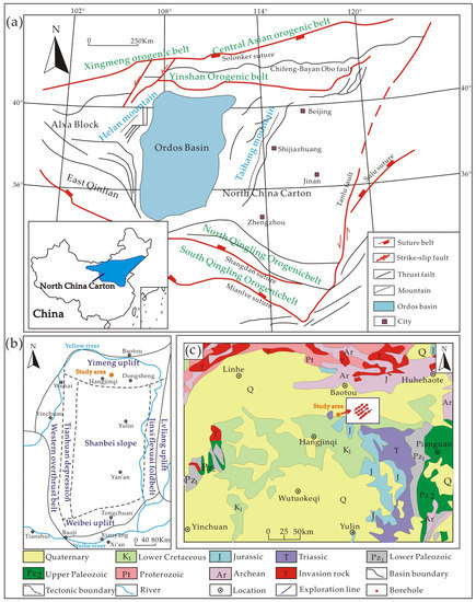
Figure 1.
Structural distribution map of the northern Ordos Basin (modified after [18]). (a) Simplified geological map of North Central China; (b) The division of tectonic units in Ordos Basin; (c) Regional geological map of northern Ordos Basin.
In the Middle–Late Triassic, the Ordos Basin was compressed and uplifted among the Paleotethys oceanic crust to the southwest, the Alashan block to the northwest and the Yangtze plate to the southeast [38,39]; it then developed into an independent large sedimentary basin. The overall tectonic pattern of the basin is tectonic belts with different characteristics developed along the basin margin, while the internal tectonic of the basin is relatively undeveloped [40]. Ordos Basin began to deposit stably in the Mesoproterozoic, which contains two basement units, direct basement and indirect basement, with the characteristics of “double” basement [41]. The indirect basement of the basin consists of Archean Palaeoproterozoic metamorphic rock series, including Archean granulite facies, amphibolite facies metamorphic rocks and migmatite granite, amphibolite and greenschist of Proterozoic. The direct basement is from Mesozoic Triassic to Quaternary [42,43] with Lower Carboniferous; moreover, Devonian and Silurian strata are absent [44], and the Triassic, Jurassic and Lower Cretaceous are the main sedimentary bodies of the basin [45].
In northern Ordos Basin, fluvial and lacustrine facies developed on an alluvial diluvial plain in the inland depression basin within early Cretaceous [46], which provided the unique geological conditions for the migration of uranium elements [47]. Cap rocks include Invasion rock, metamorphic rock of Archean and Proterozoic, Upper and Lower Paleozoic, Triassic, Jurassic, lower Cretaceous and Quaternary (Figure 1c). The Jurassic strata are the location for uranium enrichment and mineralization [48], as well as the main layer for energy enrichment such as coal, oil and natural gas [2,49]. In this paper, we selected the Daying uranium deposit within northern Ordos Basin as the research object; the geographic coordinates are 108°54′24″–109°03′20″ E, 39°55′55″–40°06′15″ N (Figure 1c), and the altitude are from 1000 to 1500 m [50]. Under the control of basement structure, the develop structural features of basement fractures, folds, faults, etc., have certain control and influence on magmatism, sedimentary diagenesis and metamorphism in the study area [51], providing unique geological conditions for the enrichment of uranium deposits [25,52].
3. Proposed NULI Method
In this section, the NULI method is proposed for uranium bearing layers of sandstone type uranium deposits identification and three-dimensional reconstruction. The proposed NULI method consists of two main parts: (1) borehole data mining and (2) identification of vertical uranium bearing layers. A detailed presentation and description of these parts is given in the following subsections.
3.1. Borehole Data Mining
Borehole data are the core for the study of sandstone type uranium deposits [41,53]. In this paper, we divide borehole data into borehole quantitative data and borehole qualitative data. The borehole quantitative data includes natural gamma irradiation rate, aperture, natural potential, apparent resistivity and density. The borehole qualitative data includes strata, stratigraphic age, aquifer, permeability and rock lithology. For one borehole, the borehole quantitative data can be expressed as a matrix, and all boreholes on an exploration line can be represented by the following matrices.
where is the sequence number of borehole, represents the k-th borehole on the exploration line,
is the number of the borehole quantitative data, are the number of sampling points for borehole quantitative data of the k-th borehole, represents the data value of the sampling point on the M-th variable in the k-th borehole. Therefore, the k-th borehole
can be expressed as follows:
where is the j-th variable in the k-th borehole and , shows the i-th data point on the j-th variable for the k-th borehole and , is the sampling number of the k-th borehole, represents the data value of the i-th sampling point on the j-th variable for the k-th borehole.
Borehole quantitative data have different data units and showing heterogeneous with different scales and resolutions. Therefore, we preprocess it into dimensionless data that can be used for metric fusion analysis; the preprocessing method is as follows:
where is the coordinate of the sampling point on the j-th variable and , , represents the data value of the j-th variable with (i + t)-th sampling point in the k-th borehole.
In this paper, we construct borehole qualitative data based on the concept of relevant component analysis [54,55]. First, we collect stratigraphic age data at different depths of each borehole, then construct a stratigraphic age constraint matrix that matches the borehole quantitative data, and the calculation formula is as follows:
where is the p-th stratigraphic age for the k-th borehole and in this paper,
represents the data point within the p-th stratigraphic age, and the total number for this stratigraphic age is , shows the data value of the l-th data point on the p-th stratigraphic age for the k-th borehole.
According to the , the borehole quantitative data can be divided into different vertical layers, and the borehole data within each vertical layer belongs to the same stratigraphic age. The total variance of borehole quantitative data for each vertical layer is calculated using the following formula:
where represents
the average of borehole quantitative data in the p-th vertical layer for
the k-th borehole, are the number of vertical layers divided in the k-th borehole.
In actual uranium mineralization process, uranium enrichment layers typically exhibit similar geological evolution characteristics, i.e., minimize the total variance within the vertical layer as much as possible. Therefore, the optimal vertical layer transformation matrix is constructed based on the above calculation results. Through the above calculation, the impact of different variables on uranium mineralization can be measured, and the transformation matrix is expressed as follows:
Based on the measurements, we assign larger weights to variables with a high degree of impact on the mineralization of sandstone type uranium deposits and assign lower weights to variables with lower impact. Then, the new borehole data measurements can be obtained, and the calculation formula is as follows:
3.2. Identification of Vertical Uranium Bearing Layers
In this section, we organize and analyze the above measurements to obtain the vertical layer features of each borehole, and express the vertical layer features as follows:
where is the depth position of the sampling points in the vertical layer, is the number of the borehole quantitative data.
Sandstone type uranium deposits typically exhibit a discontinuous “oscillation” state underground, which means they have discrete characteristics. Therefore, we conduct in-depth analysis based on Fourier thought [56,57] and power spectral density method [58,59]. Performing time/airspace analysis on , then the time/spatial function of the k-th borehole can be expressed as:
where are the average interval between sampling points of borehole data, is the parameter of and .
According to the Fourier transform, we perform an inverse Fourier transform on the time/space function and transform it into the underground vertical band range. Then, we perform the following transformation to obtain the vertical layer variation value , and the of the k-th borehole can be transformed using the following formula:
The vertical layer variation value reflects the possibility of uranium mineralization at depth t of the sampling point. Therefore, the following conditions should be met:
where are the number of sampling points in the k-th borehole and , .
4. Borehole Data
In the experiments, we selected 18 boreholes on 4 exploration lines in Daying uranium deposit within northern Ordos Basin; the 4 exploration lines are distributed in a grid shape (Figure 2 and Figure 3) and the names of the 18 boreholes are listed in Table 1. The strata involved in the 18 boreholes include the Middle Jurassic Yan’an Formation (J2y), Zhiluo Formation (J2z) and Lower Cretaceous (K1); the Zhiluo Formation can be further divided into the upper Zhiluo Formation (J2z2) and the lower Zhiluo Formation (J2z1), while the lower section of the Zhiluo Formation can be further divided into the upper sub section J2z1-2 and the lower sub section J2z1-1 (Table 2).
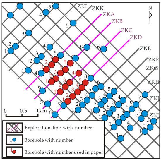
Figure 2.
Distribution map of boreholes in the four exploration lines.
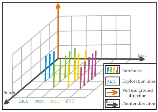
Figure 3.
Three-dimensional distribution diagram of boreholes with four exploration lines.

Table 1.
List of borehole names in the study area.

Table 2.
The vertical depth position of borehole exposed strata in the study area.
5. Results and Discussion
5.1. Identification Results of Vertical Uranium Bearing Layers
In the experiments, the vertical layer sampling thickness is set to 10 m. The vertical layer variation value is set to 0.8 for extracting the vertical uranium bearing layers, i.e., if the vertical layer variation value of the vertical uranium bearing layers are higher than 0.8, we determine there were the uranium bearing layers, otherwise it was the non-uranium bearing layer. After trial calculation, 90 vertical uranium layers were identified. According to the degree of uranium mineralization, the study area can be divided into two types, i.e., ordinary uranium mineralization layer and industrial uranium mineralization layer. These two types represent the possibility of uranium mineralization, in which industrial uranium mineralization are better than ordinary uranium mineralization. In the comparative analysis, the ordinary uranium mineralization layer and industrial uranium mineralization layer are contained within the identified 90 vertical uranium bearing layers from all the boreholes.
In the exposed strata, no vertical uranium bearing layers were identified in the Lower Cretaceous (K1) strata, whereas in the Yan’an Formation (J2y) and the Upper Zhiluo Formation (J2z2) of the Middle Jurassic, only three and two vertical uranium bearing layers were identified, respectively. The remaining vertical uranium bearing layers are all located within the Lower Zhiluo Formation (J2z1) of the Middle Jurassic, which include Upper Sub Section (J2z1-2) and Lower Sub Section (J2z1-1), accounting for 73.33% and 21.11% of the total number of vertical uranium layers, respectively (Figure 4). The Lower Zhiluo Formation in the study area is located within a depth range from 550 m to 740 m underground, indicating that most of the vertical uranium bearing layers are within this depth range, while a small portion are within the depth range from 650 m to 740 m of Lower Sub Section in Zhiluo Formation for the Middle Jurassic, indicating that a small portion of the vertical uranium bearing layers are within this depth range.
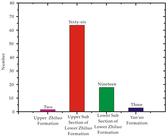
Figure 4.
The strata for the vertical uranium-bearing layers.
On the exploration lines, 11 vertical uranium bearing layers were identified in the 3 boreholes of ZKA exploration line, in which 1 layer belongs to the Lower Sub Section and the rest are all in the Upper Sun Section of Lower Zhiluo Formation, located within a depth range from 560 m to 610 m underground. For the ZKB exploration line, 27 vertical uranium bearing layers were identified from 5 boreholes, where 5 layers are located in the Lower Sub Section and the rest are located in the Upper Sub Section of the Zhiluo Formation; most of the vertical uranium bearing layers are located within a depth range from 560 m to 640 m, and only 2 layers are located within a depth range from 680 m to 700 m underground. The ZKC exploration line includes 4 boreholes and we identify 24 vertical uranium bearing layers, with only 4 layers belonging to the Lower Sub Section and the rest are all in the Upper Sub Section of Lower Zhiluo Formation, where 2 layers located within a depth range from 710 m to 730 m and the rest are all in the depth range from 560 m to 650 m underground. The ZKD exploration line includes 5 boreholes and the number of vertical uranium bearing layers are the most in 4 exploration lines; the total number are 28, 3 vertical uranium bearing layers have been identified in the Yan’an Formation of the Middle Jurassic and no vertical uranium bearing layers have been observed in the Yan’an Formation on other exploration lines. Rhe number of vertical uranium bearing layers identified in the Lower Sub Section and Upper Sub Sections of the Zhiluo Formation are 10 and 15, respectively. The depth range of the vertical uranium bearing layer is from 570 m to 740 m, which is the largest depth span and the deepest position of vertical uranium bearing layer among the 4 exploration lines (Table 3). Meanwhile, we plotted a two-dimensional vertical distribution of uranium bearing layers based on the depth position of each borehole’s vertical uranium bearing layer in the study area (Figure 5).

Table 3.
Comparison between vertical uranium-bearing layers and mineralization information from ZKA to ZKD exploration line.
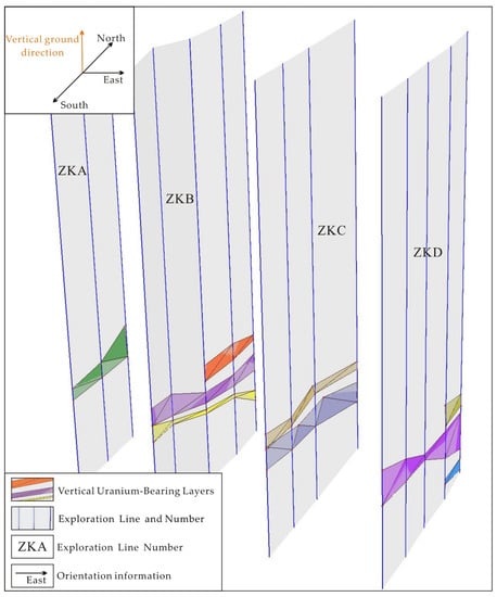
Figure 5.
Distribution map of vertical uranium-bearing layers for boreholes in the study area.
5.2. Vertical Three-Dimensional Reconstruction Analysis
In this paper, we use triangular mesh segmentation method [60,61] to perform three-dimensional reconstruction analysis on vertical uranium bearing layers of the exploration line for the Daying uranium deposit within northern Ordos Basin. Five uranium ore bodies based on the vertical uranium-bearing layers and stratigraphic age were obtained. The borehole number and depth location of the uranium ore bodies are shown in Table 4.

Table 4.
The boreholes and depth positions for uranium ore bodies.
Uranium ore body one was reconstructed and analyzed through four boreholes on the ZKA and ZKB exploration lines. The thinnest thickness is 9.95 m and the thickest thickness is 29.95 m, which is located at the intersection of Upper Sub Section for Lower Zhiluo Formation and Upper Zhiluo Formation in Middle Jurassic. Most of the ore bodies are located in the Upper Sub Section of Lower Zhiluo Formation. Only the ZKB-3 borehole has a 9.95 m deep ore body located in the Upper Zhiluo Formation (Figure 6a). Uranium ore body two was reconstructed and analyzed through five boreholes on the ZKB, ZKC and ZKD exploration lines. The thinnest thickness is 9.90 m and the thickest thickness is 19.95 m. The uranium ore bodies are all located in the Upper Sub Section of Lower Zhiluo Formation (Figure 6b). Uranium ore body three was reconstructed and analyzed with all boreholes except ZKD-3 from four exploration lines, which is the largest uranium ore body in the study area. The thinnest thickness is 9.90 m and the thickest thickness can reach 49.90 m. The ore body is mainly located in the Upper Sub Section of Lower Zhiluo Formation, and only the ZKA-3, ZKB-2 and ZKC-1 boreholes have exposed in the Lower Sub Section of Lower Zhiluo Formation (Figure 6c). Uranium ore body four and five are all reconstructed and analyzed on ZKB, ZKC and ZKD exploration lines. Uranium ore body four has including six boreholes. The thinnest thickness is 9.90 m and the thickest thickness can reach 69.89 m, which is located at the intersection of the Upper Sub Section and Lower Sub Section of Lower Zhiluo Formation (Figure 6d). Uranium ore body five has including four boreholes. The thinnest thickness is 3.60 m and the thickest thickness can reach 19.95 m, and it is located at the intersection of the Lower Sub Section of Lower Zhiluo Formation and Yan’an Formation for Middle Jurassic, which is the smallest uranium ore body in the study area (Figure 6e). By mapping the five uranium ore bodies into underground vertical three-dimensional space, we can obtain the three-dimensional reconstruction features of the uranium ore bodies for the study area (Figure 7).
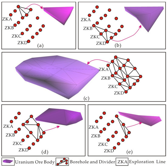
Figure 6.
Three-dimensional reconstruction features of five uranium ore bodies for the Daying uranium deposit: (a) Uranium ore body one; (b) Uranium ore body two; (c) Uranium ore body three; (d) Uranium ore body four; (e) Uranium ore body five.
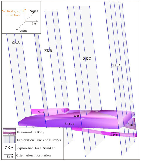
Figure 7.
Three-dimensional reconstruction features of uranium ore bodies for the Daying uranium deposit.
6. Conclusions
In this paper, we selected the Daying uranium deposit within northern Ordos Basin as the research object. According to the mineralization patterns and distribution characteristics of sandstone type uranium deposits in the underground vertical space, a nonlinear uranium-bearing layers identification (NULI) method of sandstone type uranium is established by utilizing borehole data with different types, resolutions and scales. First, borehole data were divided into the borehole quantitative data and borehole qualitative data. In the proposed NULI method, the depth and location of uranium mineralization in the vertical underground space were accurately identified by constraining the borehole quantitative data. The description of spatial distribution characteristics of vertical uranium bearing layers and three-dimensional reconstruction analysis of uranium ore bodies were achieved. In the experimental results, we found that the number of vertical uranium bearing layers are 66, located within the depth range from 550 m to 650 m in the Upper Sub Section of Lower Zhiluo Formation for the Middle Jurassic; 19 vertical uranium bearing layers are located within the depth range from 650 m to 730 m in the Lower Sub Section of Zhiluo Formation and only two and three vertical uranium bearing layers are located within the depth range from 550 m to 560 m in Upper Zhiluo Formation of Middle Jurassic and the Yan’an Formation with depth range from 720 m to 740 m.
The occurrence status of uranium ore bodies in the Daying uranium deposit within northern Ordos Basin has been intuitively depicted with the distribution characteristics of vertical uranium bearing layers. We obtained 5 uranium ore bodies, and the thinnest thickness is 9.90 m and the thickest thickness can reach 69.91 m. Uranium ore body three has the largest volume and the widest spatial distribution range, and is mainly located in the Upper Sub Section of Lower Zhiluo Formation for Middle Jurassic. The remaining four uranium ore bodies are all small in volume and distributed at the edge of the study area: uranium ore body two is located in the Upper Sub Section of the Lower Zhiluo Formation, uranium ore bodies one, four and five are located in the strata where the Upper Sub Section of Lower Zhiluo Formation intersects with the Upper Zhiluo Formation, the Lower Sub Section of Lower Zhiluo Formation and the Yan’an Formation for the Middle Jurassic.
7. Patents
The “3. Proposed NULI Method” in this manuscript has already applied for a patent, the patent number is ZL 202110686796.0.
Author Contributions
Conceptualization, Y.T.; methodology, Y.T., C.Y. and L.L.; validation, Y.T., J.Z. and Y.D.; formal analysis, Y.T. and J.Z.; investigation, Y.T. and C.Y.; data curation, L.L.; writing—original draft preparation, Y.T.; writing—review and editing, Y.T. and C.Y.; All authors have read and agreed to the published version of the manuscript.
Funding
This research was funded by Jilin Province Natural Science Foundation of Jilin Province Science and Technology Development Plan (20230101311JC), National Natural Science Foundation of China (61972054, 42272340, 42241163), the Key R&D Project of Changchun Science and Technology Development Plan (21ZY53), Jilin Higher Education Teaching Reform Research Project (JLJY202168939653), the 14th 5-Year Plan Project for Educational Science in Jilin Province (GH21364), the Key R&D Project of Jilin Province Science and Technology Development Plan (20210201127GX), the Industrial Technology R&D Special Project of Jilin Provincial Development and Reform Commission (2021C045-6).
Data Availability Statement
The data associated with this paper is confidential and may be available by contacting with the authors.
Acknowledgments
Thanks to the data support provided by Tianjin Geological Survey Center of China Geological Survey.
Conflicts of Interest
The authors declare no conflict of interest.
References
- Wang, Z.T.; Zhou, H.R.; Wang, X.L.; Jing, X.C. Characteristics of the Crystalline Basement Beneath the Ordos Basin: Constraint from Aeromagnetic Data. Geosci. Front. 2015, 6, 465–475. [Google Scholar] [CrossRef]
- Zhao, J.F.; Liu, C.Y.; Liang, J.W.; Wang, X.M.; Yu, L.; Huang, L.; Liu, Y.T. Restoration of the Original Sedimentary Boundary of the Middle Jurassic Zhiluo Formation-Anding Formation in the Ordos Basin. Acta Geol. Sin. 2010, 84, 553–569. [Google Scholar]
- Guo, Q.Y. Tectonic Evolution at the Western Margin of Ordos Basin with Respect to Metallogenesis of Sandstone Type Uranium Deposits. Ph.D. Dissertation, China University of Geosciences, Beijing, China, 2010; pp. 1–253. [Google Scholar]
- Liu, Z.Y.; Peng, S.P.; Qin, M.K.; Huang, S.H.; Geng, Y.Y.; He, Z.B. Constraints on Sandstone-Type Uranium Deposits by the Tectonic Uplift and Denudation Process in the Eastern Junggar Basin, Northwest China: Evidence from Apatite Fission Track and Detrital Zircon U-Pb Ages. Minerals 2022, 12, 905. [Google Scholar] [CrossRef]
- Aizhulov, D.; Tungatarova, M.; Kaltayev, A. Streamlines Based Stochastic Methods and Reactive Transport Simulation Applied to Resource Estimation of Roll-Front Uranium Deposits Exploited by In-Situ Leaching. Minerals 2022, 12, 1209. [Google Scholar] [CrossRef]
- Zhao, L. Sedimentary Characteristics and Its Hydrogeological Significance of Jurassic ZhiLuo Formation in the East of Ningxia. Master’s Thesis, Shandong University of Science and Technology, Qingdao, China, 2011. [Google Scholar]
- Gao, X.Y.; Zhao, T.P. Late Mesozoic Magmatism and Tectonic Evolution in the Southern mMargin of the North China Craton. Sci. China Earth Sci. 2017, 60, 1959–1975. [Google Scholar] [CrossRef]
- Wan, Y.S.; Xie, H.Q.; Yang, H.; Wang, Z.J.; Liu, D.Y.; Kröner, A.; Wilde, S.A.; Geng, Y.S.; Sun, L.Y.; Ma, M.Z.; et al. Is the Ordos Block Archean or Paleoproterozoic in Age Implications for the Precambrian Evolution of the North China Carton. Am. J. Sci. 2013, 313, 683–711. [Google Scholar] [CrossRef]
- Diwu, C.R.; Sun, Y.; Wilde, S.A.; Wang, H.L.; Dong, Z.C.; Zhang, H.; Wang, Q. New Evidence for 4.45 Ga Terrestrial Crust from Zircon Xenocrysts in Ordovician Ignimbrite in the North Qinling Orogenic Belt, China. Gondwana Res. 2013, 23, 1484–1490. [Google Scholar] [CrossRef]
- Xing, E.Y.; Zhang, Y.S.; Zheng, M.P.; Wu, S.J.; Gui, B.L.; Peng, Y. Geochemistry, U-Pb Zircon Ages and Hf Isotopes of Basement Rocks Beneath the Northeastern Margin of the Ordos Basin: Constraints on the Paleoproterozoic Evolution of the Western North China Craton. Minerals 2022, 12, 865. [Google Scholar] [CrossRef]
- Kurmanseiit, M.B.; Tungatarova, M.S.; Kaltayev, A.; Royer, J.-J. Reactive Transport Modeling during Uranium in Situ Leaching (ISL): The Effects of Ore Composition on Mining Recovery. Minerals 2022, 12, 1340. [Google Scholar] [CrossRef]
- Liu, C.Y. Advances in the Accumulation and Formation for Multi-Energy Mineral Deposits Coexisting in the Same Basin; Science Press: Beijing, China, 2015; pp. 1–25. [Google Scholar]
- Li, Z.H.; Dong, S.W.; Feng, S.B.; Qu, H.J. Sedimentary Response to Middle-Late Jurassic Tectonic Events in the Ordos Basin. Acta Geosci. Sin. 2015, 36, 22–30. [Google Scholar]
- Yue, L.; Jiao, Y.; Fayek, M.; Wu, L.; Rong, H. Micromorphologies and Sulfur Isotopic Compositions of Pyrite in Sandstone-Hosted Uranium Deposits: A Review and Implications for Ore Genesis. Ore Geol. Rev. 2021, 139, 104512. [Google Scholar] [CrossRef]
- Tao, Z.; Jiao, Y.; Wu, L.; Rong, H.; Zhang, F.; Yue, L. Architecture of a Sandstone Uranium Reservoir and the Spatial Distribution of its Internal Carbonaceous Debris: A Case Study of the Zhiluo Formation, Eastern Ordos Basin, Northern China. J. Asian Earth Sci. 2020, 191, 104219. [Google Scholar] [CrossRef]
- Tao, R.; Shu, X.; Hai, L.; Guo, P.; Lin, L.; Tian, J.; Xu, Q.; Wang, L. Significance of Sandstone Provenance in Tracking Potential Uranium Reservoirs: A Case Study of the Middle Jurassic Zhiluo Formation, Western Ordos Basin, Northern China. J. Asian Earth Sci. 2022, 227, 105117. [Google Scholar] [CrossRef]
- Zhu, Q.; Yu, R.; Feng, X.; Li, J.; Sima, X.; Tang, C.; Xu, Z.; Liu, X.; Si, Q.; Li, G.; et al. Mineralogy, Geochemistry, and Fluid Action Process of Uranium Deposits in the Zhiluo Formation, Ordos Basin, China. Ore Geol. Rev. 2019, 111, 102984. [Google Scholar] [CrossRef]
- Cai, Y.; Ouyang, F.; Luo, X.; Zhang, Z.; Wen, M.; Luo, X.; Tang, R. Geochemical Characteristics and Constraints on Provenance, Tectonic Setting, and Paleoweathering of Middle Jurassic Zhiluo Formation Sandstones in the Northwest Ordos Basin, North-Central China. Minerals 2022, 12, 603. [Google Scholar] [CrossRef]
- Luo, X.; Li, Z.; Cai, Y.; Yi, C.; Zhang, Z.; Zhang, Y.; Zhang, Y. Provenance and Tectonic Setting of Lower Cretaceous Huanhe Formation Sandstones, Northwest Ordos Basin, North-Central China. Minerals 2021, 11, 1376. [Google Scholar] [CrossRef]
- Zhu, Q.; Li, J.; Wen, S.; Li, G.; Yu, R.; Miao, P.; Zhang, B. Alteration, Uranium Occurrence State, and Enrichment Mechanism of the Cretaceous Luohe Formation, Southwestern Ordos Basin, Western China. Ore Geol. Rev. 2021, 139, 104486. [Google Scholar] [CrossRef]
- Yu, R.A.; Wang, S.B.; Zhu, Q.; Si, Q.H.; Teng, X.M.; Liu, X.X.; Liu, H.N.; Tang, Y.X. Zircon U-Pb Ages and Provenance Characteristics of the Zhiluo Formation Sandstones and the Formation Background of the Uranium Deposit in Huangling Area, Ordos Basin, China. China Geol. 2021, 4, 600–615. [Google Scholar] [CrossRef]
- Chen, L.; Chen, Y.; Feng, X.; Li, J.G.; Guo, H.; Miao, P.; Jin, R.; Tang, C.; Zhao, H.; Wang, G.; et al. Uranium Occurrence State in the Tarangaole Area of the Ordos Basin, China: Implications for Enrichment and Mineralization. Ore Geol. Rev. 2019, 115, 103034. [Google Scholar] [CrossRef]
- Cai, Y.; Han, M.; Zhang, C.; Chao, Y.I.; Xiaocui, L.I.; Zhang, Y.; Wang, G.; Huaming, L.I. Geological and Geochemical Characteristics of the Zhiluo Formation in the Bayinqinggeli Uranium Deposit, Northern Ordos Basin: Significance for Uranium Mineralization. Acta Geol. Sin. 2021, 95, 2075–2086. [Google Scholar] [CrossRef]
- Xue, R. Sedimentary Characteristics of the Jurassic Zhiluo Formation in Northern Ordos Basin and Implications for Uranium Mineralization. Master’s Thesis, Northwest University, Xi’an, China, 2017. [Google Scholar]
- Jiao, Y.Q.; Wu, L.Q.; Rong, H.; Peng, Y.B.; Miao, A.S.; Wang, X.M. The Relationship Between Jurassic Coal Measures and Sandstone-type Uranium Deposits in the Northeastern Ordos Basin, China. Acta Geol. Sin. 2016, 90, 2117–2132. [Google Scholar] [CrossRef]
- Lei, K.Y. Comparative Research on Sedimentary Characteristics and Provenance of Zhiluo Formation in the Northern Ordos Basin and Southern Ordos Basin. Master’s Thesis, Northwest University, Xi’an, China, 2016. [Google Scholar]
- Luo, W. Sedimentary Evolution and Provenance Analysis of the Middle Jurassic Zhiluo Formation in Majiatan-Huianbao Area, Western Ordos Basin. Master’s Thesis, Northwest University, Xi’an, China, 2017. [Google Scholar]
- Yang, J.; Wang, S.B.; Liu, F. Sedimentary Facies of the Zhiluo Formation and its Relationship with Uranium Mineralization in the Huanxian Area, West of Ordos Basin. Sci. Technol. Eng. 2019, 19, 64–70. [Google Scholar]
- Wu, Z.J.; Yan, M.H.; Han, X.Z.; Yu, R.A.; Sima, X.Z.; Jiang, Z.; Yin, D.F.; Hu, H.; Deng, Y.T. Uranium Metallogenic Characteristics and Prospecting Significance of Hongqingliang Area in Northeastern Ordos basin. Coal Geol. Explor. 2019, 47, 22–31. [Google Scholar]
- Chen, R.; Wang, F.; Li, Z.; Evans, N.J.; Chen, H.; Wei, X. Late Paleozoic Provenance Shift in the East-central Ordos Basin: Implications for the Tectonic Evolution of the North China Craton. J. Asian Earth Sci. 2021, 215, 104799. [Google Scholar] [CrossRef]
- Deng, J.; Wang, Q.F.; Gao, B.F.; Huang, D.H.; Yang, L.Q.; Xu, H.; Zhou, Y.H. Evolution of the Ordos Basin and its Distribution of Various Energy and Mineral Resources. Geoscience 2005, 19, 538–545. [Google Scholar]
- Fan, B.; Dai, X.; Wang, C. Gas Desorption Characteristics of the Chang 7 Member Shale in the Triassic Yanchang Formation, Yan’an Area, Ordos Basin. Minerals 2023, 13, 622. [Google Scholar] [CrossRef]
- Jiang, L.; Qiu, Z.; Wang, Q.C.; Guo, Y.S.; Wu, C.F.; Wu, Z.J.; Xue, Z.H. Joint Development and Tectonic Stress Field Evolution in the Southeastern Mesozoic Ordos Basin, West part of North China. J. Asian Earth Sci. 2016, 127, 47–62. [Google Scholar] [CrossRef]
- Liu, C.Y.; Wang, J.Q.; Zhang, D.D.; Zhao, H.G.; Zhao, J.F.; Huang, L.; Wang, W.Q.; Qin, Y. Genesis of Rich Hydrocarbon Resources and their Occurrence and Accumulation Characteristics in the Ordos Basin. Oil Gas Geol. 2021, 42, 1011–1029. [Google Scholar]
- Ritts, B.D.; Hanson, A.D.; Darby, B.J.; Nanson, L.; Berry, A. Sedimentaryrecord of Triassic Intraplate Extension in North China: Evidence from the Nonmarine NW Ordos Basin, Helan Shan and Zhuozi Shan. Tectonophysics 2004, 386, 177–202. [Google Scholar] [CrossRef]
- Shao, S.Z. Study on Jurassic Sedimentary System and Main Sand Bodies in Yulin–Yan’an Area. Ordos Basin. Master’s Thesis, China University of Geoscience, Beijing, China, 2005. [Google Scholar]
- Li, S.G.; Ge, N.; Liu, D.; Zhang, Z.; Ye, X.; Zheng, S.; Peng, C. The Sm-Nd Isotopic Age of C–type Eclogite from Dabie Group in the Northern Dabie Mountains and its Tectonic Implication. Chin. Sci. Bull. 1989, 34, 1623–1628. [Google Scholar]
- Liu, S.; Yang, S. Upper Triassic-Jurassic Sequence Stratigraphy and its Structural Controls in the Western Ordos basin, China. Basin Res. 2000, 12, 1–18. [Google Scholar] [CrossRef]
- Liu, Y.Q.; Kuang, H.W.; Peng, N.; Xu, H.; Zhang, P.; Wang, N.S.; An, W. Mesozoic Basins and Associated Palaeogeographic Evolution in North China. J. Palaeogeogr. 2015, 4, 189–202. [Google Scholar] [CrossRef]
- Chen, L.L.; Feng, X.X.; Sima, X.Z.; Li, J.G.; Guo, H.; Chen, Y.; Zhao, H.L.; Tang, C.; Wang, G.; Liu, Z.R. Occurrence Forms of the Uranium Minerals in the Nalinggou Area of the Ordos Basin and Geological Implications. Geol. Explor. 2017, 53, 632–642. [Google Scholar]
- Tan, Y.L. Research on the Vertical Spatial Zoning and Ore-Bearing Layers Recognition of Sandstone Uranium Deposit–A Case Study of the Daying Uranium Deposit in Northern Ordos Basin. Ph.D. Dissertation, Jilin University, Changchun, China, 2021. [Google Scholar]
- Liu, C.Y.; Zhao, H.G.; Zhao, J.F.; Wang, J.Q.; Zhang, D.D.; Yang, M.H. Temporospatial Coordinates of Evolution of the Ordos Basin and its Mineralization Responses. Acta Geol. Sin. 2006, 82, 1229–1243. [Google Scholar]
- Liu, Y.; Xu, Q.; Li, X.; Zhan, W.; Guo, J.; Xiao, J. A Small-Sample Borehole Fluvial Facies Identification Method Using Generative Adversarial Networks in the Context of Gas-Fired Power Generation, with the Hangjinqi Gas Field in the Ordos Basin as an Example. Energies 2023, 16, 1361. [Google Scholar] [CrossRef]
- Zhu, Q.; Li, J.G.; Miao, P.S. Reservoir Characteristics of Luohe Formation and Metallogenic Geological Conditions of Deep Uranium in the Southwestern Margin of Ordos Basin, China. J. Earth Sci. Environ. 2019, 41, 675–690. [Google Scholar]
- Cao, H.F.; Liu, H.N.; Du, P.; Peng, X.H. Characteristics of Shuanglong Uranium Deposit and the Types of Uranium Mineral in the Southern Margin of Ordos Basin. Geol. Sci. Technol. Inf. 2018, 37, 148–153. [Google Scholar]
- Xie, Y.; Wang, J.; Li, L.X.; Xie, Z.W.; Deng, G.S.; Li, M.H.; Jiang, X.H. Disbution of the Cretaceous Clay Minerals in Ordos basin, China and its Implication to Sedimentary and Diagenetic Environment. Geol. Bull. China 2010, 29, 93–104. [Google Scholar]
- Zhang, Y.; Sun, L.X.; Zhang, T.F.; Cheng, Y.H.; Li, Y.F.; Ma, H.L.; Lu, C.; Yang, C.; Guo, J.C.; Zhou, X.G. Sequence Stratigraphy Study of Coal Uranium Bearing Rock Series and Occurrence Regularity Coal and Uranium in the Northeastern Margin of Ordos Basin. Acta Geol. Sin. 2016, 90, 3424–3440. [Google Scholar]
- Jin, R.S.; Feng, X.X.; Teng, X.M.; Nie, F.J.; Cao, H.Y.; Hou, H.Q.; Liu, H.X.; Miao, P.S.; Zhao, H.L.; Chen, L.L. Genesis of Green Sandstone/Mudstone from Middle Jurassic Zhiluo Formation in the Dongsheng Uranium Orefield, Ordos Basin and its Enlightenment for Uranium Mineralization. China Geol. 2020, 3, 52–66. [Google Scholar] [CrossRef]
- Zhao, J.F.; Liu, C.Y.; Yu, L.; Huang, L.; Liu, Y.T.; Gao, F. Distributional and Sedimentary Characteristics of Sandstones in Jurassic Zhiluo Formation, Ordos Basin. Acta Sedimentol. Sin. 2007, 25, 535–544. [Google Scholar]
- Cao, M.X. Research and Application on Geospatial Digital Spectrum Model. Ph.D. Dissertation, Jilin University, Changchun, China, 2017. [Google Scholar]
- Cui, L.; Peng, N.; Liu, Y.; Qiao, D.; Liu, Y. Sedimentary Filling Evolution under Paleoclimate Transition—A Case Study from the Middle Jurassic Zhiluo Formation, Ordos Basin. Minerals 2023, 13, 314. [Google Scholar] [CrossRef]
- Wang, X.P.; Liu, K.P.; Chen, H.B.; Gong, B.L.; Yu, H.W.; Gong, Q.F.; Han, D. Sedimentary Characteristics of the Jurassic Zhiluo Formation and Uranium Deposits in Zhiluo-Diantou Area, Southern Ordos Basin. J. Paleogeogr. 2020, 22, 295–307. [Google Scholar]
- Herron, M.M. Geochemical Classification of Terrigenous Sands and Shales from Core or Log Data. J. Sediment. Res. 1988, 58, 820–829. [Google Scholar]
- Shental, N.; Hertz, T.; Weinshall, D.; Pavel, M. Adjustment Learning and Relevant Component Analysis. Comput. Vis. -ECCV 2022, 2353, 181–185. [Google Scholar]
- Bar-Hillel, A.; Hertz, T.; Shental, N.; Weinshall, D.; Ridgeway, G. Learning a Mahalanobis Metric from Equivalence Constraints. J. Mach. Lea. Res. 2005, 6, 937–965. [Google Scholar]
- Cooley, J.W.; Tukey, J.W. An Algorithm for the Machine of Complex Fourier Series. Math. Comput. 1965, 19, 297–301. [Google Scholar] [CrossRef]
- Boehme, T.K. The Fourier Transform and its Applications. Am. Math. Mon. 1966, 73, 685. [Google Scholar] [CrossRef]
- Elson, J.M.; Bennett, J.M. Calculation of the Power Spectral Density from Surface Profile Data. Appl. Opt. 1995, 34, 201–208. [Google Scholar] [CrossRef]
- Laguna, P.; Moody, G.B.; Mark, R.G. Power Spectral Density of Unevenly Sampled Data by Least-Square Analysis: Performance and Application to Heart Rate Signals. IEEE Trans. Biome. Eng. 1998, 45, 698–715. [Google Scholar] [CrossRef] [PubMed]
- Lee, K.; Johnson, R.K.; Yin, Y.; Wahle, A.; Olszewski, M.E.; Scholz, T.D.; Sonka, M. Three-Dimensional Thrombus Segmentation in Abdominal Aortic Aneurysms Using Graph Search Based on a Triangular Mesh. Comput. Biol. Med. 2010, 40, 271–278. [Google Scholar] [CrossRef] [PubMed]
- Srinark, T.; Kambhamettu, C. A Novel Method for 3D Surface Mesh Segmentation. In Proceedings of the Sixth IASTED International Conference on Computer Graphics and Imaging, Honolulu, HI, USA, 13–15 August 2003. [Google Scholar]
Disclaimer/Publisher’s Note: The statements, opinions and data contained in all publications are solely those of the individual author(s) and contributor(s) and not of MDPI and/or the editor(s). MDPI and/or the editor(s) disclaim responsibility for any injury to people or property resulting from any ideas, methods, instructions or products referred to in the content. |
© 2023 by the authors. Licensee MDPI, Basel, Switzerland. This article is an open access article distributed under the terms and conditions of the Creative Commons Attribution (CC BY) license (https://creativecommons.org/licenses/by/4.0/).