

Application of ASTER Remote Sensing Data to Porphyry Copper Exploration in the Gondwana Region

 , and
, and
Abstract
1. Introduction
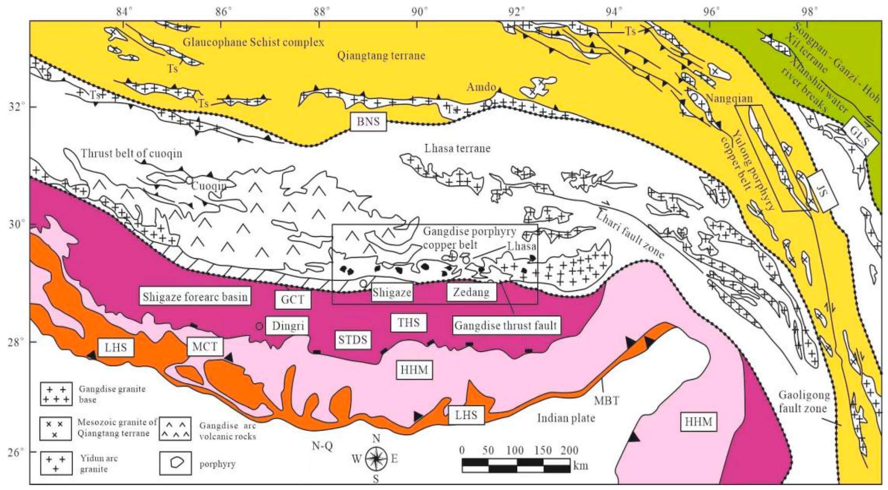
2. Geological Background of the Study Area
3. Data and Methods
3.1. Multi-Source Satellite Remote Sensing Data and Features
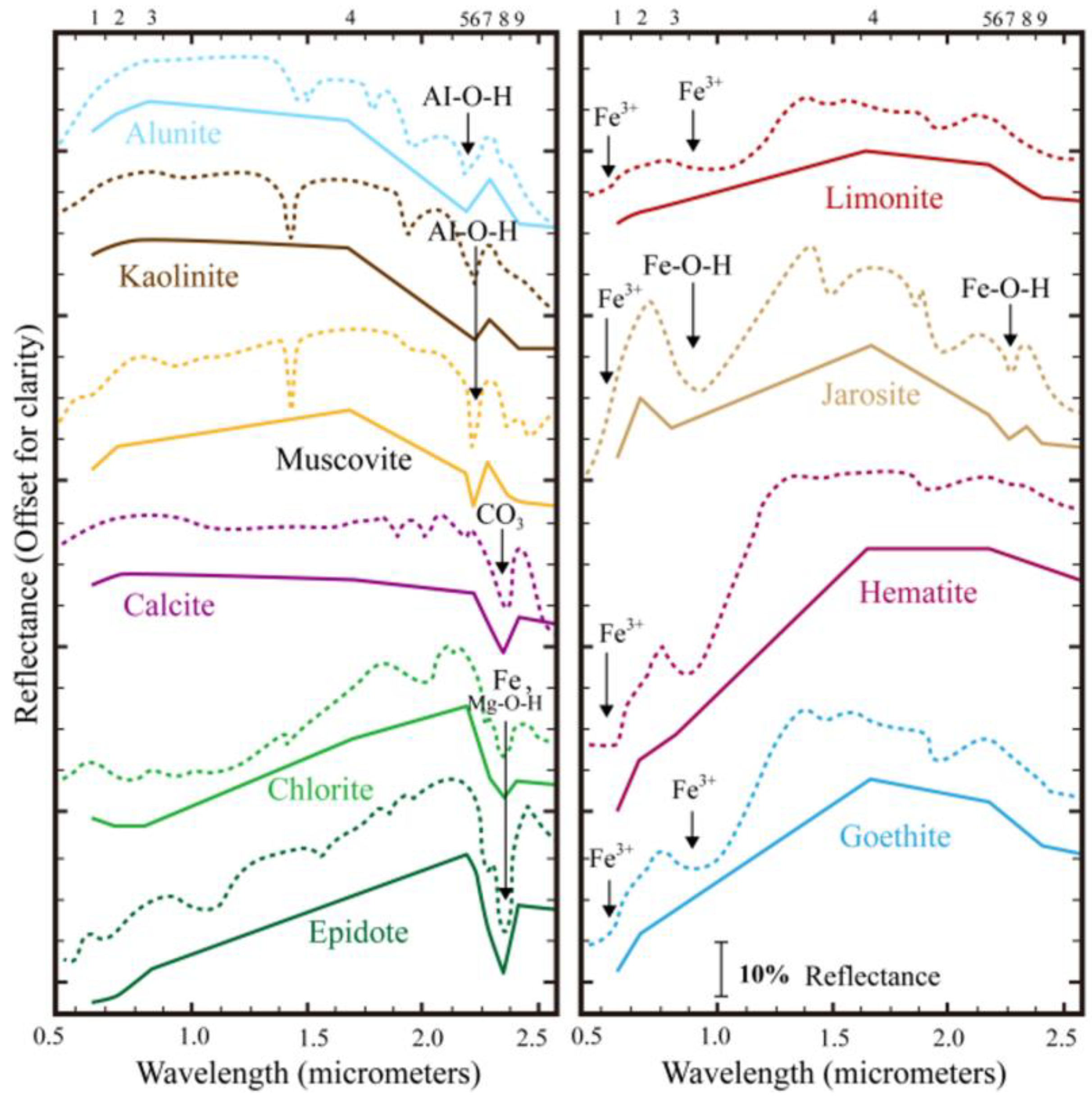
3.2. Wave Spectral Characteristics of Alteration Minerals
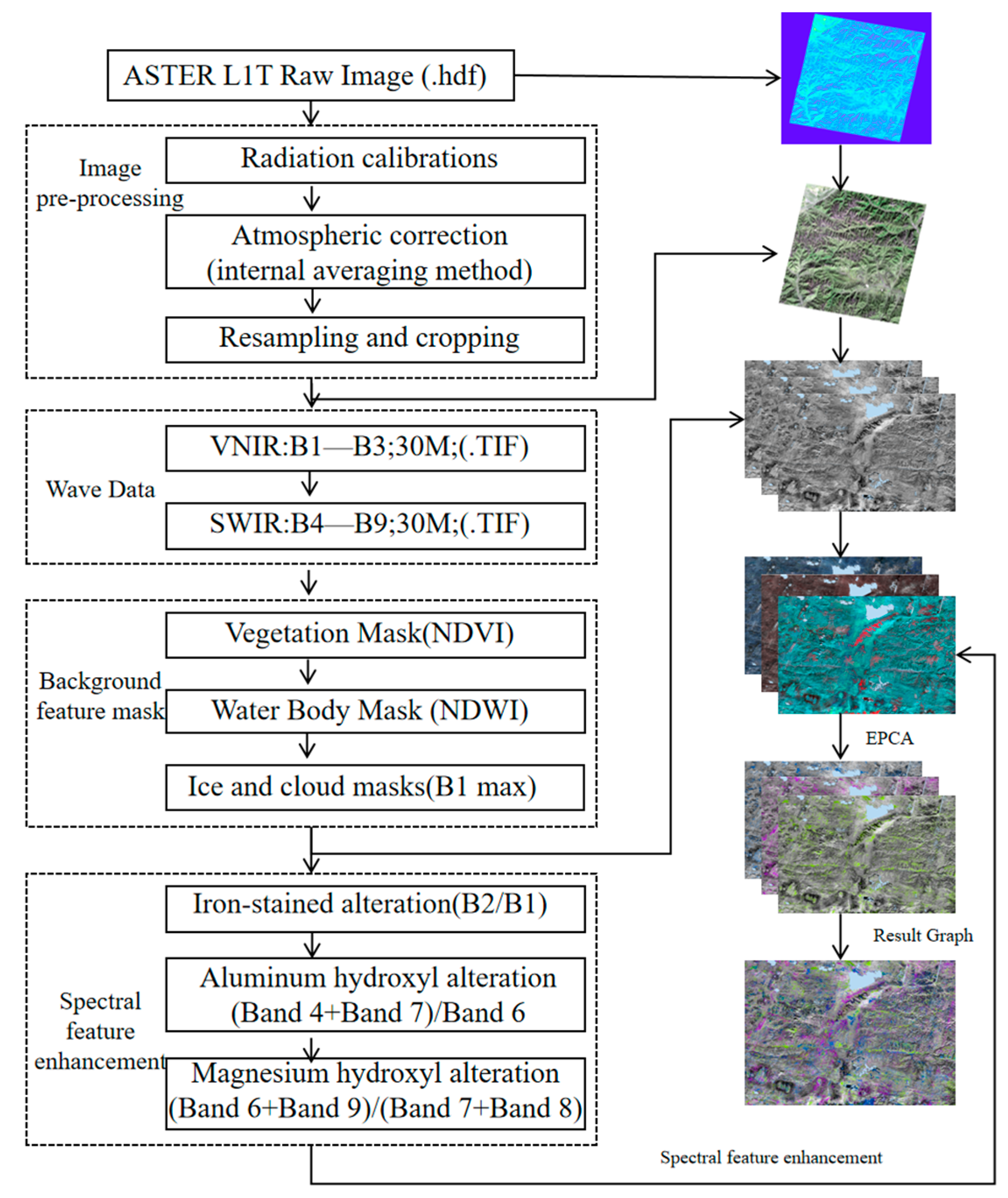
3.3. Data Pre-Processing
3.4. Principal Component Analysis Methods for Spectral Feature Enhancement
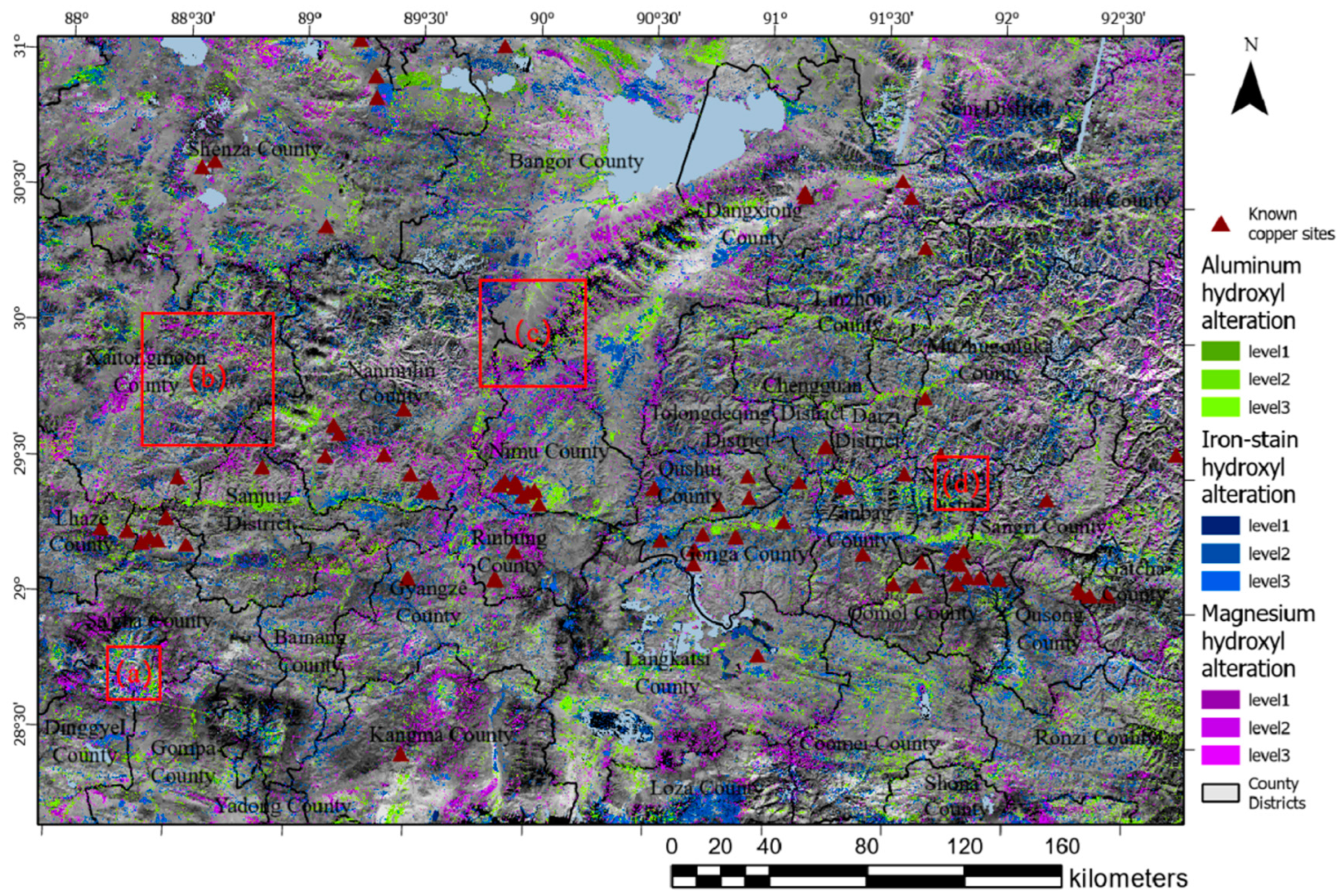
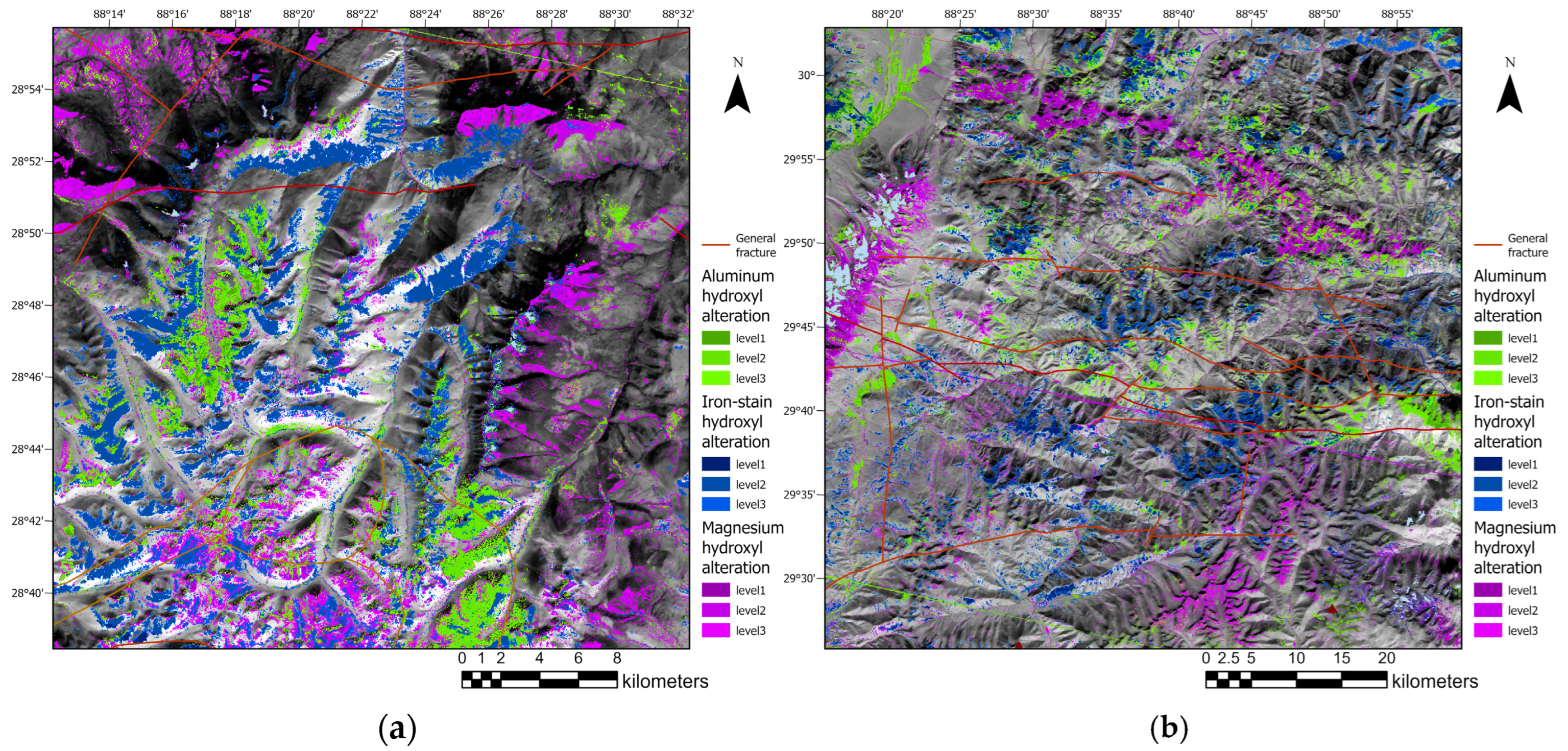
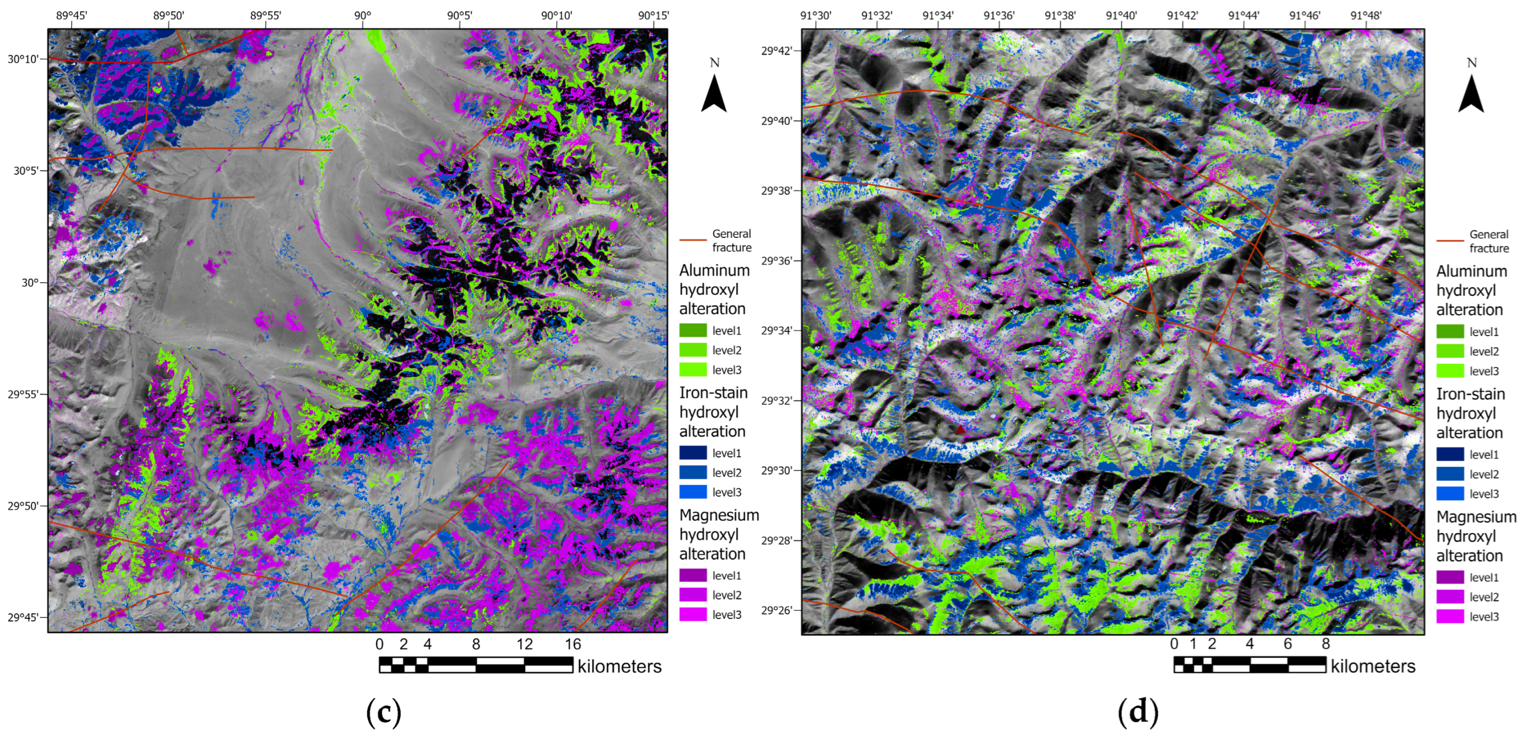
4. Results and Analysis
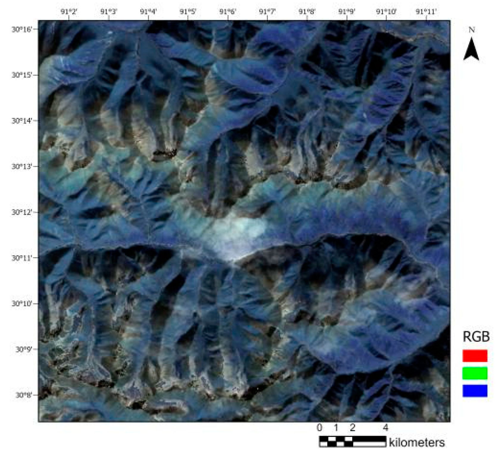
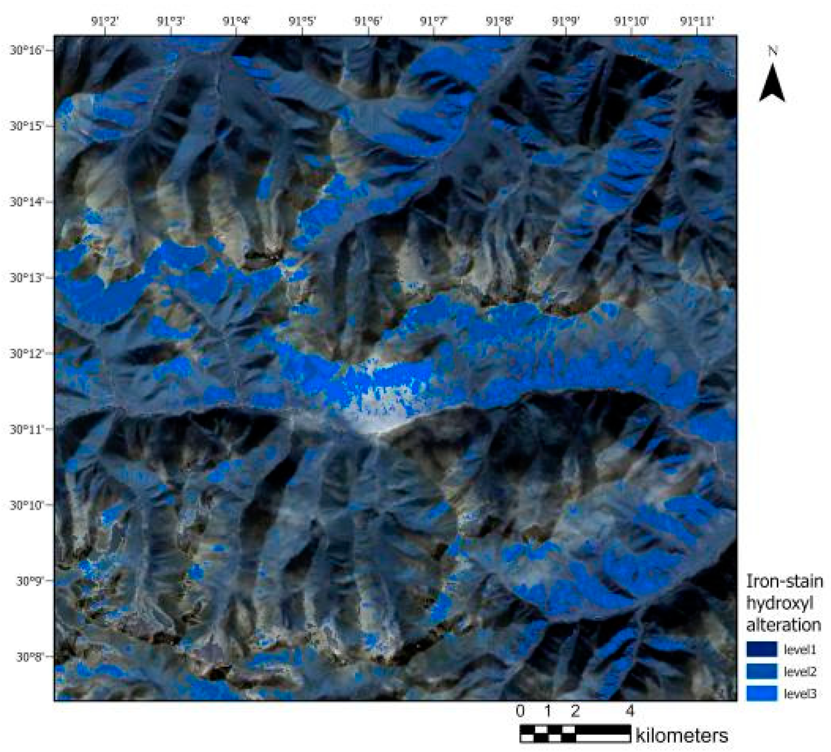
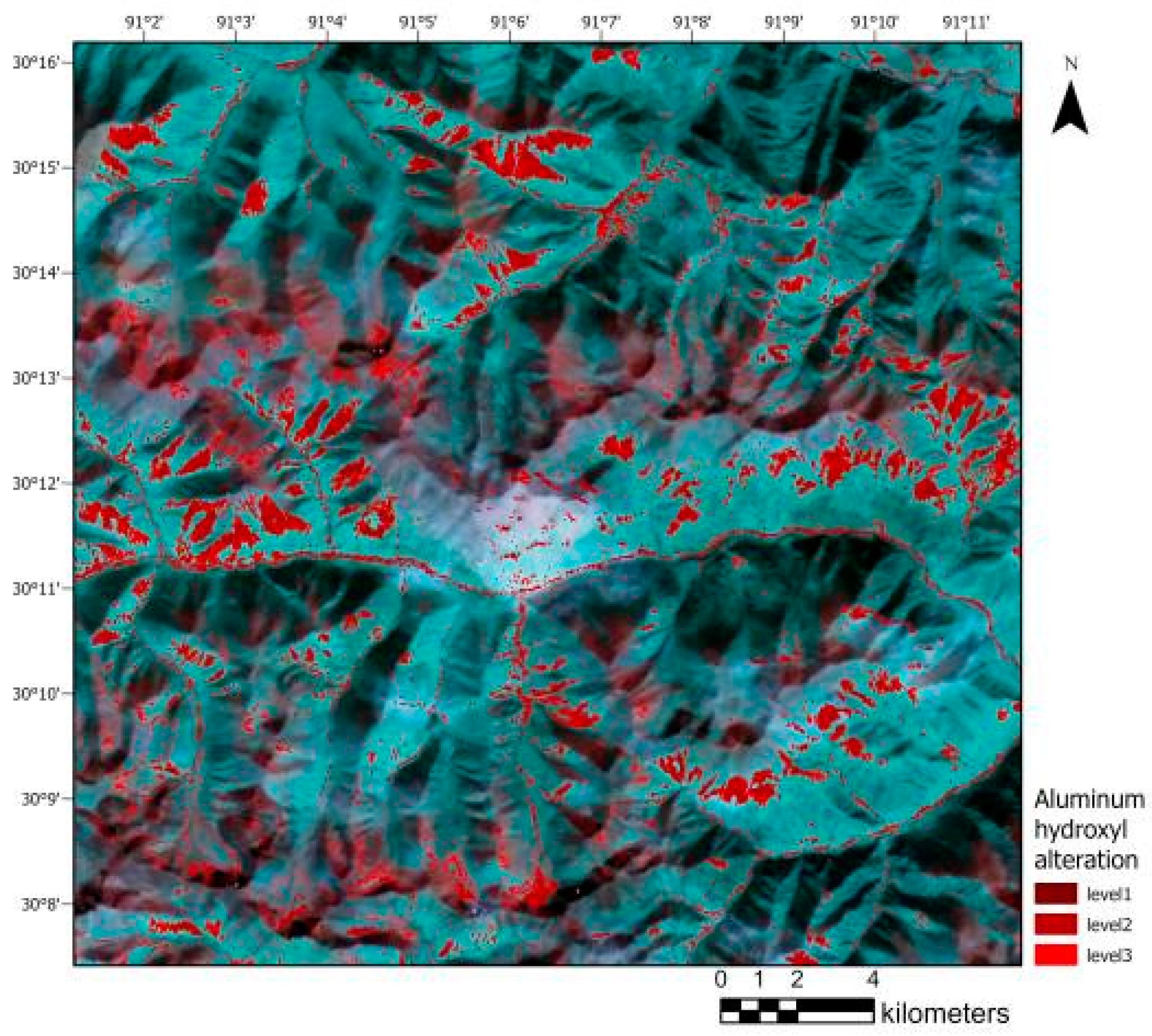
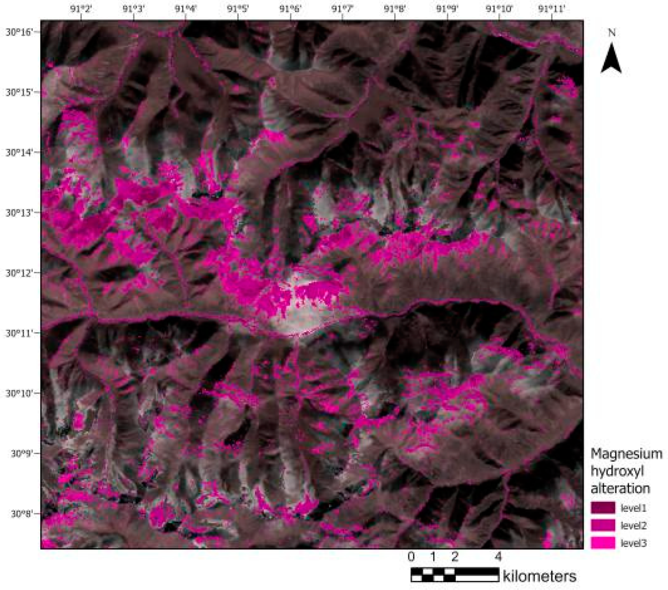
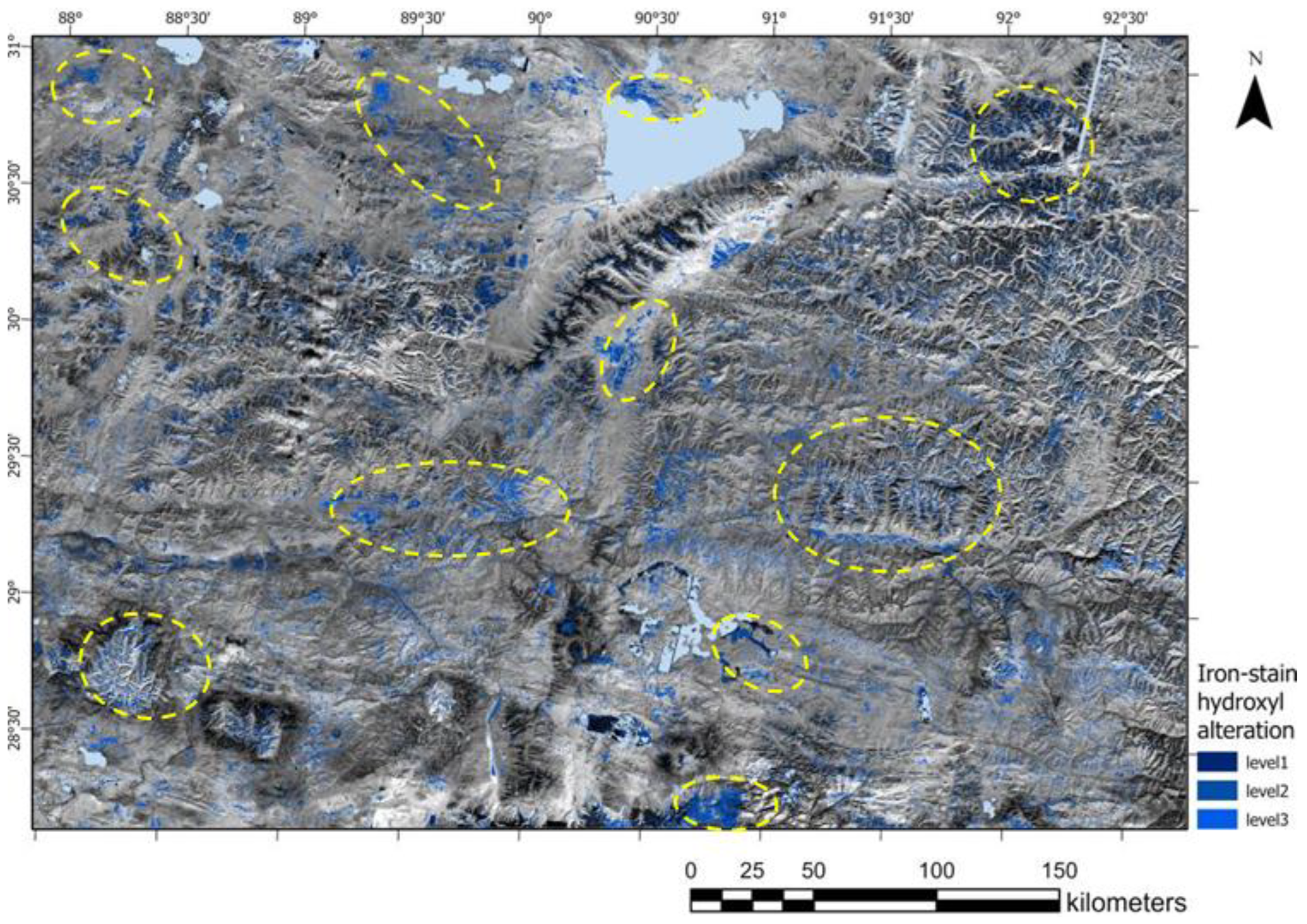
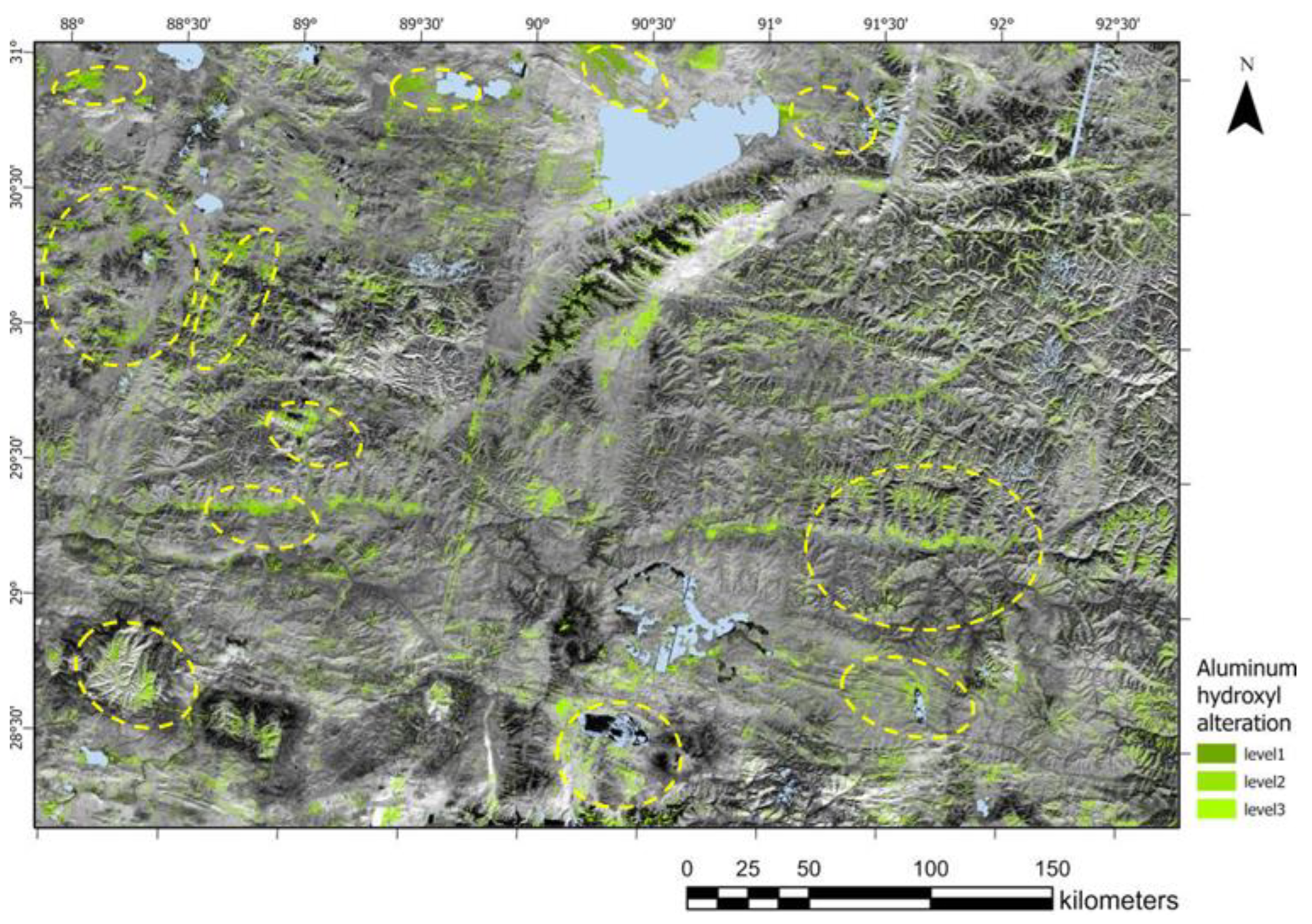
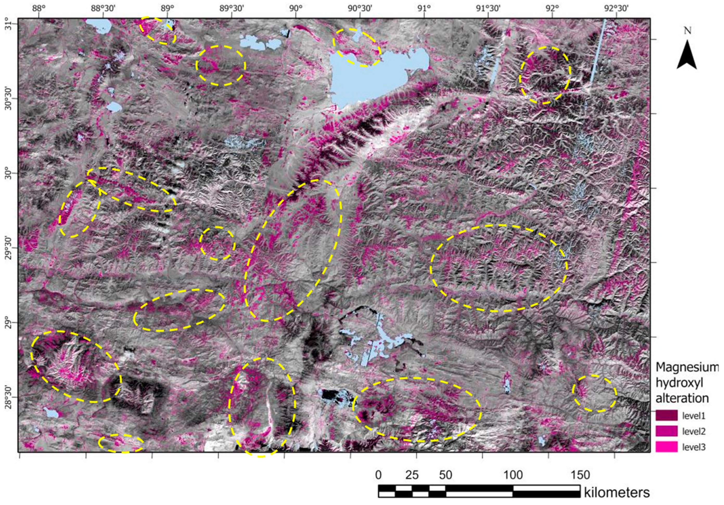
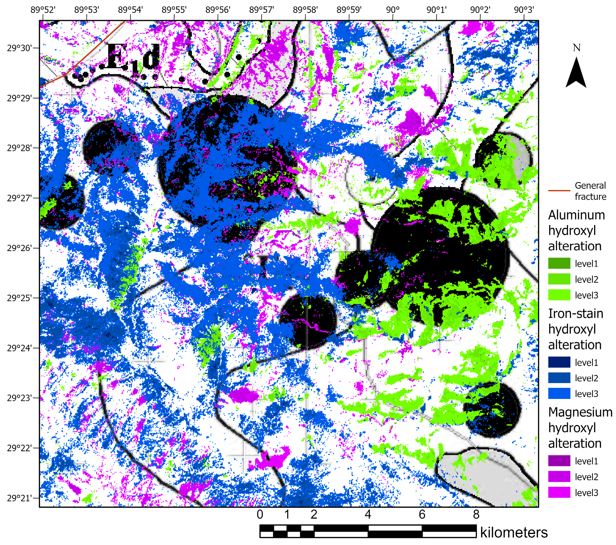
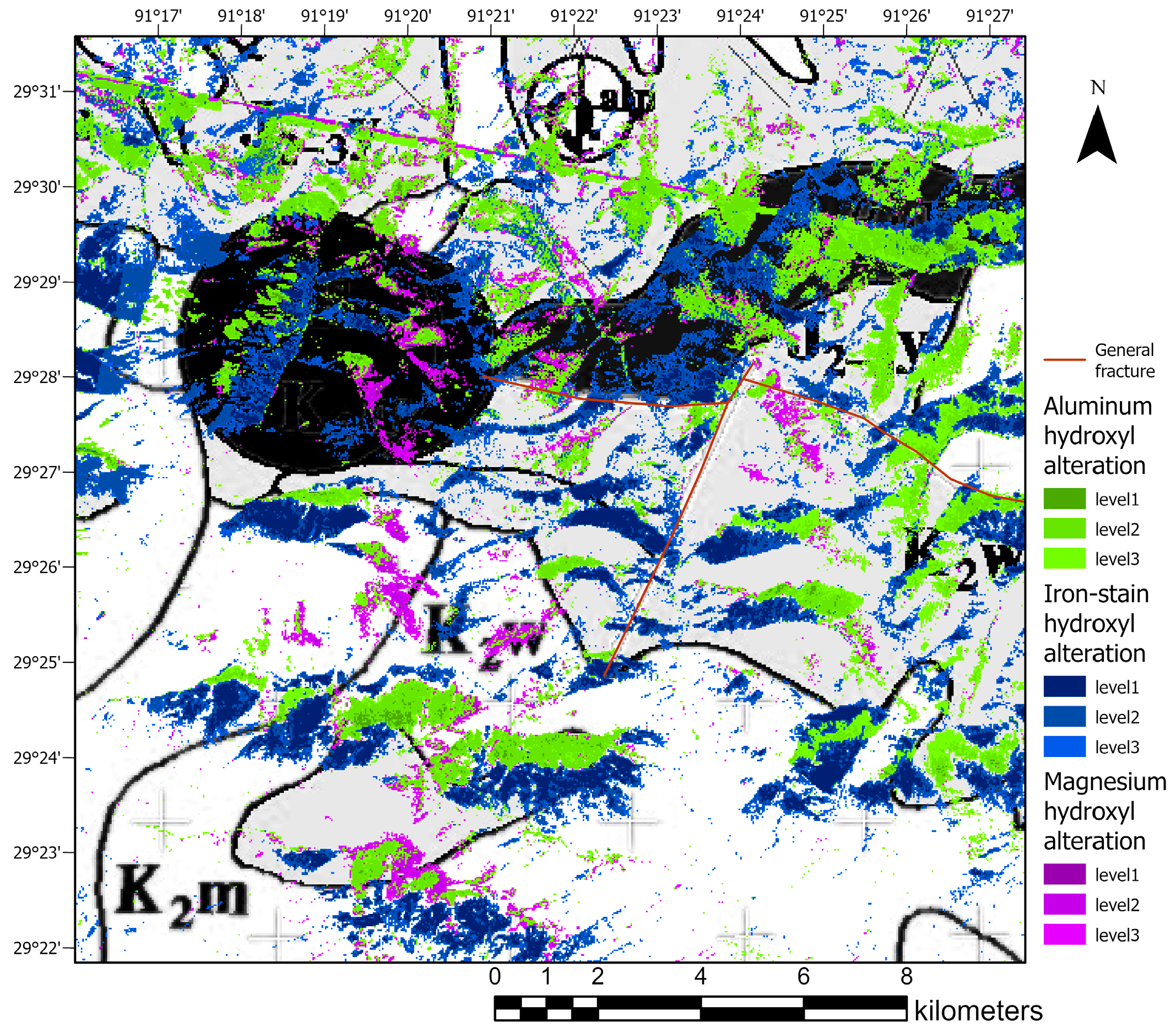
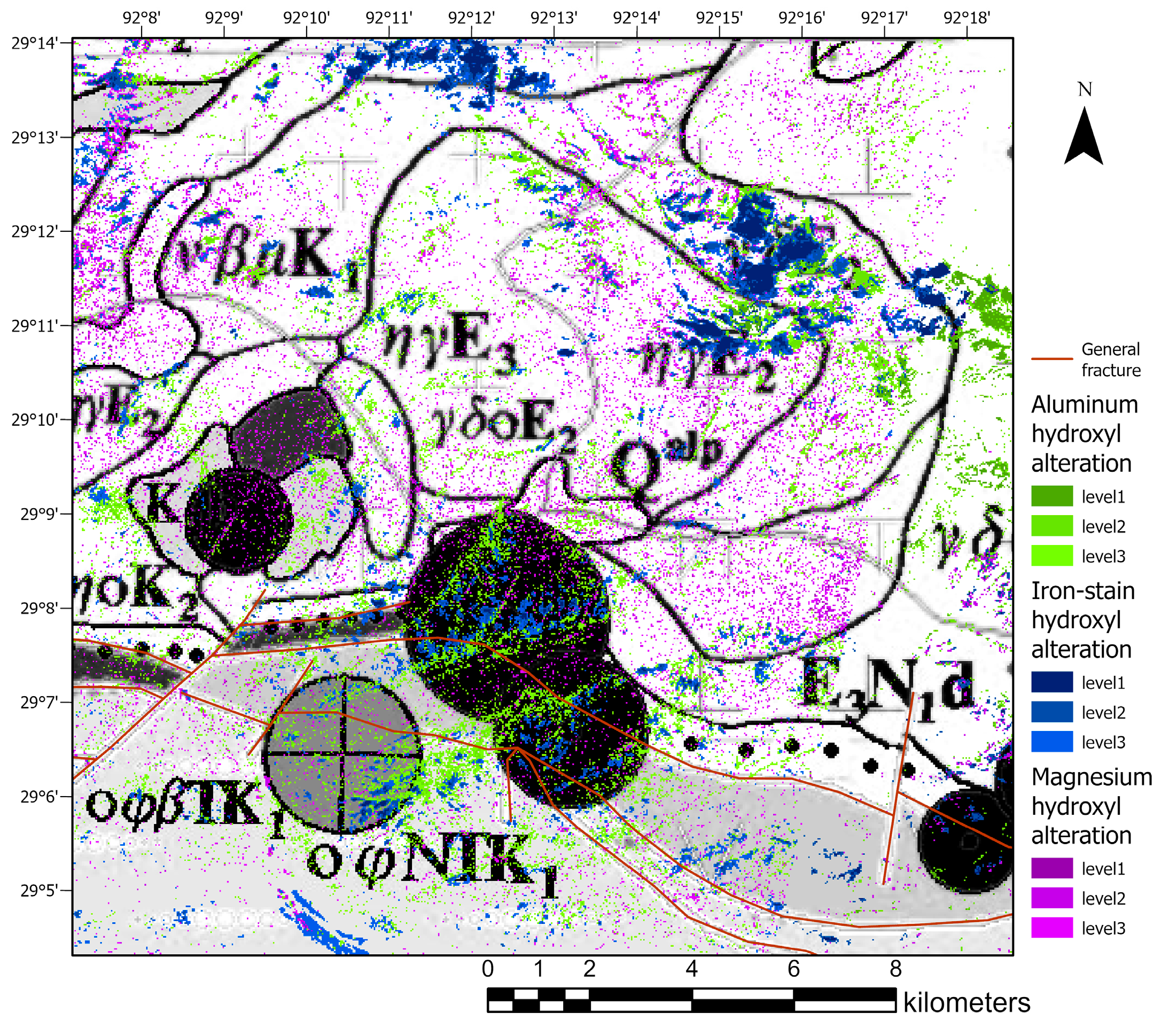
4.1. Extraction of Alteration Information


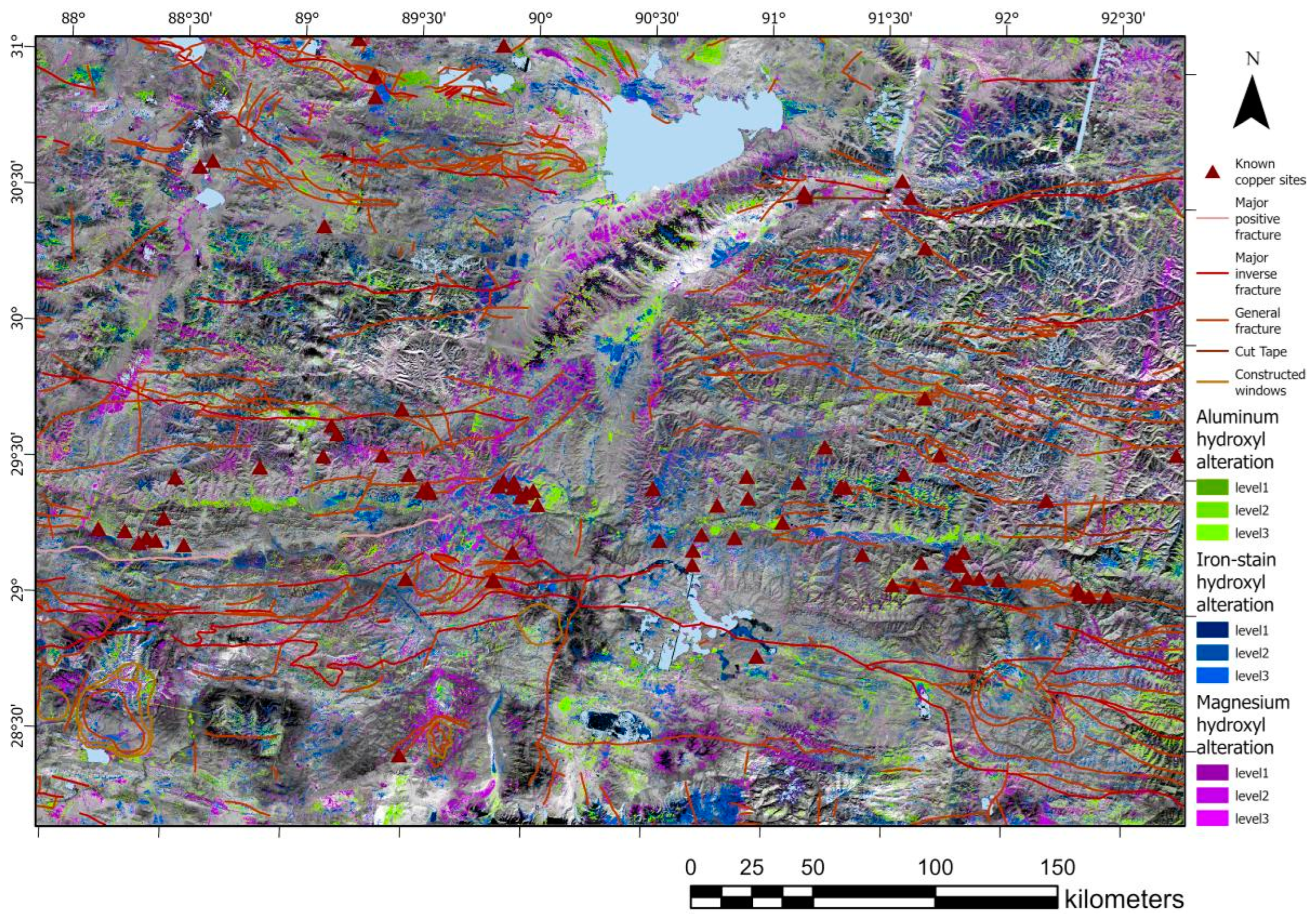
4.2. Integrated Analysis of Multi-Source Geological Elements
5. Discussion
6. Conclusions
Author Contributions
Funding
Data Availability Statement
Acknowledgments
Conflicts of Interest
References
- Sun, W.; Huang, R.F.; Li, H.; Hu, Y.B.; Zhang, C.C.; Sun, S.J.; Zhang, L.P.; Ding, X.; Li, C.Y.; Zartman, R.E.; et al. Porphyry deposits and oxidized magmas. Ore Geol. Rev. 2015, 65, 97–131. [Google Scholar] [CrossRef]
- Xu, X.W.; Li, H.; Peters, S.G.; Qin, K.; Mao, Q.; Wu, Q.; Hong, T.; Wu, C.; Liang, G.; Zhang, Z.; et al. Cu-rich porphyry magmas produced by fractional crystallization of oxidized fertile basaltic magmas (Sangnan, East Junggar, P.R. China). Ore Geol. Rev. 2017, 91, 296–315. [Google Scholar] [CrossRef]
- Windley, B.F.; Xiao, W. Ridge subduction and slab windows in the Central Asian Orogenic Belt: Tectonic implications for the evolution of an accretionary orogen. Gondwana Res. 2018, 61, 73–87. [Google Scholar] [CrossRef]
- Shebl, A.; Abdellatif, M.; Elkhateeb, S.O.; Csámer, Á. Multisource data analysis for gold potentiality mapping of Atalla area and its environs, Central Eastern Desert, Egypt. Minerals 2021, 11, 641. [Google Scholar] [CrossRef]
- Eldosouky, A.M.; Abdelkareem, M.; Elkhateeb, S.O. Integration of remote sensing and aeromagnetic data for mapping structural features and hydrothermal alteration zones in Wadi Allaqi area, South Eastern Desert of Egypt. J. Afr. Earth Sci. 2017, 130, 28–37. [Google Scholar] [CrossRef]
- Alimohammadi, M.; Alirezaei, S.; Kontak, D.J. Application of ASTER data for Exploration of porphyry copper deposits: A case study of Daraloo–Sarmeshk area, southern part of the Kerman copper belt, Iran. Ore Geol. Rev. 2015, 70, 290–304. [Google Scholar] [CrossRef]
- Alarifi, S.S.; Abdelkareem, M.; Abdalla, F.; Abdelsadek, I.S.; Gahlan, H.; Al-Saleh, A.; Alotaibi, M. Fusion of Multispectral Remote-Sensing Data through GIS-Based Overlay Method for Revealing Potential Areas of Hydrothermal Mineral Resources. Minerals 2022, 12, 1577. [Google Scholar] [CrossRef]
- Traore, M.; Wambo, J.D.T.; Ndepete, C.P.; Tekin, S.; Pour, A.B.; Muslim, A.M. Lithological and alteration mineral mapping for alluvial gold exploration in the south east of Birao area, Central African Republic using Landsat-8 Operational Land Imager (OLI) data. J. Afr. Earth Sci. 2020, 170, 103933. [Google Scholar] [CrossRef]
- Taha, A.M.M.; Xi, Y.; He, Q.; Hu, A.; Wang, S.; Liu, X. Investigating the Capabilities of Various Multispectral Remote Sensors Data to Map Mineral Prospectivity Based on Random Forest Predictive Model: A Case Study for Gold Deposits in Hamissana Area, NE Sudan. Minerals 2022, 13, 49. [Google Scholar] [CrossRef]
- Mbianya, G.N.; Ngnotue, T.; Wambo, J.D.T.; Ganno, S.; Pour, A.B.; Kenne, P.A.; Fossi, D.H.; Wolf, I.D. Remote sensing satellite-based structural/alteration mapping for gold exploration in the Ketté goldfield, Eastern Cameroon. J. Afr. Earth Sci. 2021, 184, 104386. [Google Scholar] [CrossRef]
- Ketchaya, Y.B.; Dong, G.; Fotze, Q.M.A.; Carrino, T.A.; Mandeng, E.P.B.; Lemdjou, Y.B.; Assie, K.R.; Fodoue, Y.; Wadjou, J.W. Integration of Landsat 8, gravity, and field data for exploration of gold mineralization in Gamba District, Northern Cameroon. Geol. J. 2021, 56, 4788–4808. [Google Scholar] [CrossRef]
- Belgrano, T.M.; Diamond, L.W.; Novakovic, N.; Hewson, R.D.; Hecker, C.A.; Wolf, R.C.; Zielinski, L.D.; Kuhn, R.; Gilgen, S.A. Multispectral discrimination of spectrally similar hydrothermal minerals in mafic crust: A 5000 km2 ASTER alteration map of the Oman–UAE ophiolite. Remote Sens. Environ. 2022, 280, 113211. [Google Scholar] [CrossRef]
- Timkin, T.; Abedini, M.; Ziaii, M.; Ghasemi, M.R. Geochemical and Hydrothermal Alteration Patterns of the Abrisham-Rud Porphyry Copper District, Semnan Province, Iran. Minerals 2022, 12, 103. [Google Scholar] [CrossRef]
- Yousefi, M.; Tabatabaei, S.H.; Rikhtehgaran, R.; Pour, A.B.; Pradhan, B. Application of Dirichlet process and support vector machine techniques for mapping alteration zones associated with porphyry copper deposit using ASTER remote sensing imagery. Minerals 2021, 11, 1235. [Google Scholar] [CrossRef]
- El-Wahed, M.A.; Zoheir, B.; Pour, A.B.; Kamh, S. Shear-related gold ores in the Wadi Hodein Shear Belt, South Eastern Desert of Egypt: Analysis of remote sensing, field and structural data. Minerals 2021, 11, 474. [Google Scholar] [CrossRef]
- Karamizadeh, S.; Abdullah, S.M.; Manaf, A.A.; Zamani, M.; Hooman, A. An overview of principal component analysis. J. Signal Inf. Process. 2013, 4, 173. [Google Scholar] [CrossRef]
- Gao, J.; Klemd, R.; Zhu, M.; Wang, X.; Li, J.; Wan, B.; Xiao, W.; Zeng, Q.; Shen, P.; Sun, J.; et al. Large-scale porphyry-type mineralization in the Central Asian metallogenic domain: A review. J. Asian Earth Sci. 2018, 165, 7–36. [Google Scholar] [CrossRef]
- Cooke, D.R.; Hollings, P.; Wilkinson, J.J.; Tosdal, R.M. Geochemistry of Porphyry Deposits. In Treatise on Geochemistry, 2nd ed.; Holland, H.D., Turekian, K.K., Eds.; Elsevier: Oxford, UK, 2014; Volume 13, pp. 357–381. [Google Scholar]
- Richards, J.P. Magmatic to hydrothermal metal fluxes in convergent and collided margins. Ore Geol. Rev. 2011, 40, 1–26. [Google Scholar] [CrossRef]
- Guo, N.; Thomas, C.; Tang, J.X.; Tong, Q.X. Mapping white mica alteration associated with the Jiama porphyry-skarn Cu deposit, central Tibet using field SWIR spectrometry. Ore Geol. Rev. 2019, 108, 147–157. [Google Scholar] [CrossRef]
- Yao, F.; Xu, X.; Yang, J.; Geng, X. A Remote-Sensing-Based Alteration Zonation Model of the Duolong Porphyry Copper Ore District, Tibet. Remote Sens. 2021, 13, 5073. [Google Scholar] [CrossRef]
- Tang, N.; Qin, Z.; Li, Y.; Duo, J.; Ran, F.; Dai, J. Mineralogical Characteristics and Short-wave Infrared Spectra of Chlorite as Indicators of Hydrothermal Centers: A Case Study of the Giant Porphyry Copper-Molybdenum Deposit at Qulong, Tibet. Acta Geol. Sin.-Engl. Ed. 2022, 96, 490–505. [Google Scholar] [CrossRef]
- Ding, F.; Gao, J.G.; Xu, K.Z. Geochemistry, geochronology, and geological significances of the essential dykes in the Rongbu area, southern Tibet. Acta Petrol. Sin. 2020, 36, 18. [Google Scholar]
- Zeng, L.S.; Gao, L.E.; Guo, C.L.; Hou, K.J.; Wang, Q. Early Cretaceous forearc extension of the Gangdese continental arc, southern Tibet. Acta Petrol. Sin. 2017, 33, 18. [Google Scholar]
- Tang, J.; Dorji; Liu, H.; Lang, X.; Zhang, J.; Zheng, W.; Ying, L. Mineralization pattern and mineralization prediction of the eastern section of the Gondwana mineralization belt. J. Geol. 2014, 88, 11. [Google Scholar]
- Cao, H.; Li, G.; Zhang, R.; Zhang, Y.; Zhang, L.; Dai, Z.; Zhang, Z.; Liang, W.; Dong, S.; Xia, X.B. Genesis of the Cuonadong tin polymetallic deposit in the Tethyan Himalaya: Evidence from geology, geochronology, fluid inclusions and multiple isotopes. Gondwana Res. 2021, 92, 72–101. [Google Scholar] [CrossRef]
- Cao, S.; Wang, Z.; Lou, F.; Huang, J.; Xiong, W. Ore formation pattern and prospect analysis of iron-copper ore in central Tibetan Gangdis. J. Geol. 2014, 88, 2108–2118. [Google Scholar]
- Hou, Z.; Qu, X.; Wang, S.; Gao, Y.; Du, A.; Huang, W. Re-Os ages of gabbroic molybdenite in the Gangdis porphyry copper belt, Tibetan Plateau: Application of mineralization time frame and kinetic background. Chin. Sci. Ser. D 2003, 33, 609–618. [Google Scholar]
- Yin, A. Geologic Evolution of the Himalayan-Tibetan Orogen. Annu. Rev. Earth Planet. Sci. 2000, 28, 211–280. [Google Scholar] [CrossRef]
- Lyu, P.; He, L.; He, Z.; Liu, Y.; Deng, H.; Qu, R.; Wang, J.; Zhao, Y.; Wei, Y. Research on remote sensing prospecting technology based on multi-source data fusion in deep-cutting areas. Ore Geol. Rev. 2021, 138, 104359. [Google Scholar] [CrossRef]
- Pour, A.B.; Hashim, M.; Marghany, M. Using spectral mapping techniques on short wave infrared bands of ASTER remote sensing data for alteration mineral mapping in SE Iran. Int. J. Phys. Sci. 2011, 6, 917–929. [Google Scholar]
- Diao, H.; Zhang, D.; Di, Y.; Wang, Z.; Wang, H.; Xiong, G. The Extraction of Alteration Anomalies from ASTER Data Based on Principal Component Analysis and Fractal Model. Remote Sens. Land Resour. 2011, 23, 75–80. [Google Scholar]
- Amer, R.; El Mezayen, A.; Hasanein, M. ASTER spectral analysis for alteration minerals associated with gold mineralization. Ore Geol. Rev. J. Compr. Stud. Ore Genes. Ore Explor. 2016, 75, 239–251. [Google Scholar] [CrossRef]
- Khaleghi, M.; Ranjbar, H.; Abedini, A.; Calagari, A.A. Synergetic use of the Sentinel-2, ASTER, and Landsat-8 data for hydrothermal alteration and iron oxide minerals mapping in a mine scale. Acta Geodyn. Geromater. 2020, 17, 311–329. [Google Scholar] [CrossRef]
- Fakhari, S.; Jafarirad, A.; Afzal, P.; Lotfi, M. Delineation of hydrothermal alteration zones for porphyry systems utilizing ASTER data in Jebal-Barez area, SE Iran. Iran. J. Earth Sci. 2019, 11, 80–92. [Google Scholar]
- Nafigin, I.O.; Ishmukhametova, V.T.; Ustinov, S.A.; Minaev, V.A.; Petrov, V.A. Geological and Mineralogical Mapping Based on Statistical Methods of Remote Sensing Data Processing of Landsat-8: A Case Study in the Southeastern Transbaikalia, Russia. Sustainability 2022, 14, 9242. [Google Scholar] [CrossRef]
- Bertoldi, L.; Massironi, M.; Visonà, D.; Carosi, R.; Montomoli, C.; Gubert, F.; Naletto, G.; Pelizzo, M.G. Mapping the Buraburi granite in the Himalayas of Western Nepal: Remote sensing analysis in a collisional belt with vegetation cover and extreme variation of topography. Remote Sens. Environ. 2011, 115, 1129–1144. [Google Scholar] [CrossRef]
- Ayoobi, I.; Tangestani, M.H. Evaluation of relative atmospheric correction methods on ASTER VNIR–SWIR data in playa environment. Carbonates Evaporites 2017, 32, 539–546. [Google Scholar] [CrossRef]
- Pour, A.B.; Hashim, M.; van Genderen, J. Detection of hydrothermal alteration zones in a tropical region using satellite remote sensing data: Bau goldfield, Sarawak, Malaysia. Ore Geol. Rev. 2013, 54, 181–196. [Google Scholar] [CrossRef]
- Wang, Z.; Zhou, C.; Qin, H. Detection of hydrothermal alteration zones using ASTER data in Nimu porphyry copper deposit, south Tibet, China. Adv. Space Res. 2020, 65, 1818–1830. [Google Scholar] [CrossRef]
- Crosta, A.P.; Moore, J. Enhancement of Landsat Thematic Mapper imagery for residual soil mapping in SW Minais Gerais State, Brazil: A prospecting case history in greenstone belt terrain. In Proceedings of the 7th (ERIM) Thematic Conference: Remote Sensing for Exploration Geology, Calgary, AB, Canada, 2–6 October 1989; pp. 1173–1187. [Google Scholar]
- Adiri, Z.; Lhissou, R.; El Harti, A.; Jellouli, A.; Chakouri, M. Recent advances in the use of public domain satellite imagery for mineral exploration: A review of Landsat-8 and Sentinel-2 applications. Ore Geol. Rev. 2020, 117, 103332. [Google Scholar] [CrossRef]
- Sojdehee, M.; Rasa, I.; Nezafati, N.; Abedini, M.V. Application of spectral analysis to discriminate hydrothermal alteration zones at Daralu copper deposit, SE Iran. Arab. J. Geosci. 2016, 9, 41. [Google Scholar] [CrossRef]
- Fang, C.; Xu, B.; Hu, F.; Chen, X.; Liu, Y. Cu-polymetallic Deposit Prognosis in the Banggonghu-Nujiang Metallogenic Belt Based on ASTER Remote Sensing Alterration Information Extraction. Resour. Environ. Eng. 2016, 68, 65–82. [Google Scholar]
- Zheng, W.; Liu, B.; McKinley, J.M.; Cooper, M.R.; Wang, L. Geology and geochemistry-based metallogenic exploration model for the eastern Tethys Himalayan metallogenic belt, Tibet. J. Geochem. Explor. 2021, 224, 106743. [Google Scholar] [CrossRef]
- Rajabpour, S.; Hassanpour, S.; Radmard, K.; Moghaddasi, S.J. Nature and genesis of the Zaglic Au deposit, NW Iran: Constraints from geochemical studies. J. Geochem. Explor. 2022, 238, 107001. [Google Scholar] [CrossRef]
- Ghelichkhani, M.; Shafaroudi, A.M.; Karimpour, M.H.; Homam, S.M. Zangalou Manto-type deposit in the Sabzevar zone, northeast Iran: Evidence of mineralogy, geochemistry, U–Pb dating, fluid inclusion, and stable isotopes. Geol. J. 2023, 58, 465–496. [Google Scholar] [CrossRef]
- Andongma, W.T.; Gajere, J.N.; Amuda, A.K.; Edmond, R.R.D.; Faisal, M.; Yusuf, Y.D. Mapping of hydrothermal alterations related to gold mineralization within parts of the Malumfashi Schist Belt, North-Western Nigeria. Egypt. J. Remote Sens. Space Sci. 2021, 24, 401–417. [Google Scholar] [CrossRef]
- Atif, Y.; Soulaimani, A.; Lamqadem, A.A.; Pour, A.B.; Pradhan, B.; Nouamane, E.A.; Abdelali, K.; Muslim, A.M.; Hossain, M.S. Identifying hydrothermally altered rocks using ASTER satellite imageries in Eastern Anti-Atlas of Morocco: A case study from Imiter silver mine. Int. J. Image Data Fusion 2021, 13, 337–361. [Google Scholar] [CrossRef]
- Fu, Y.; Cheng, Q.; Jing, L.; Ye, B.; Fu, H. Mineral Prospectivity Mapping of Porphyry Copper Deposits Based on Remote Sensing Imagery and Geochemical Data in the Duolong Ore District, Tibet. Remote Sens. 2023, 15, 439. [Google Scholar] [CrossRef]
- Mansurov, M.I.; Imamverdiyev, N.A.; Karimov, V.M.; Ganbarova, E.F.; Damirov, T.J.; Mursalov, S.S.; Pashayev, N.V. The discovery of structural elements and zones of hydrothermal alterations by using ASTER satellite data in the margins of Gadabay and Murovdag ore districts (Lesser Caucasus, Azerbaijan). J. Geol. Geogr. Geoecol. 2021, 30, 512–527. [Google Scholar] [CrossRef]
- Long, K.R.; Van Gosen, B.S.; Foley, N.K.; Cordier, D. The Principal Rare Earth Elements Deposits of the United States: A Summary of Domestic Deposits and a Global Perspective; Springer: Dordrecht, The Netherlands, 2012. [Google Scholar]
- Xie, Y.; Hou, M.Z.; Li, C. Anisotropic characteristics of acoustic emission and the corresponding multifractal spectrum during progressive failure of shale under cyclic loading. Int. J. Rock Mech. Min. Sci. 2023, 165, 105364. [Google Scholar] [CrossRef]
- Wang, Q.; Wang, Y.; He, M.; Jiang, B.; Li, S.; Jiang, Z.; Wang, Y.; Xu, S. Experimental research and application of automatically formed roadway without advance tunneling. Tunn. Undergr. Space Technol. 2021, 114, 103999. [Google Scholar] [CrossRef]


| Remote Sensing Data | Channel | Waveband Number | Spectral Range/μm | Spatial Resolution/m |
|---|---|---|---|---|
| ASTER | VNIR | 1 | 0.52–0.60 | 15 |
| 2 | 0.63–0.69 | |||
| 3N | 0.78–0.86 | |||
| 3B | 0.78–0.86 | |||
| SWIR | 4 | 1.600–1.700 | 30 | |
| 5 | 2.145–2.185 | |||
| 6 | 2.185–2.225 | |||
| 7 | 2.235–2.285 | |||
| 8 | 2.295–2.365 | |||
| 9 | 2.360–2.430 |
Disclaimer/Publisher’s Note: The statements, opinions and data contained in all publications are solely those of the individual author(s) and contributor(s) and not of MDPI and/or the editor(s). MDPI and/or the editor(s) disclaim responsibility for any injury to people or property resulting from any ideas, methods, instructions or products referred to in the content. |
© 2023 by the authors. Licensee MDPI, Basel, Switzerland. This article is an open access article distributed under the terms and conditions of the Creative Commons Attribution (CC BY) license (https://creativecommons.org/licenses/by/4.0/).
Share and Cite
Liu, C.; Qiu, C.; Wang, L.; Feng, J.; Wu, S.; Wang, Y. Application of ASTER Remote Sensing Data to Porphyry Copper Exploration in the Gondwana Region. Minerals 2023, 13, 501. https://doi.org/10.3390/min13040501
Liu C, Qiu C, Wang L, Feng J, Wu S, Wang Y. Application of ASTER Remote Sensing Data to Porphyry Copper Exploration in the Gondwana Region. Minerals. 2023; 13(4):501. https://doi.org/10.3390/min13040501
Chicago/Turabian StyleLiu, Chunhui, Chunxia Qiu, Luoqi Wang, Jie Feng, Sensen Wu, and Yuanyuan Wang. 2023. "Application of ASTER Remote Sensing Data to Porphyry Copper Exploration in the Gondwana Region" Minerals 13, no. 4: 501. https://doi.org/10.3390/min13040501
APA StyleLiu, C., Qiu, C., Wang, L., Feng, J., Wu, S., & Wang, Y. (2023). Application of ASTER Remote Sensing Data to Porphyry Copper Exploration in the Gondwana Region. Minerals, 13(4), 501. https://doi.org/10.3390/min13040501