

The Main Controlling Factors on the Evolution of the Cambrian Carbonate Platform in the Tarim Basin and Its Implications for the Distribution of Ultra-Deep Dolomite Reservoirs
Abstract
:1. Introduction
2. Geological Setting
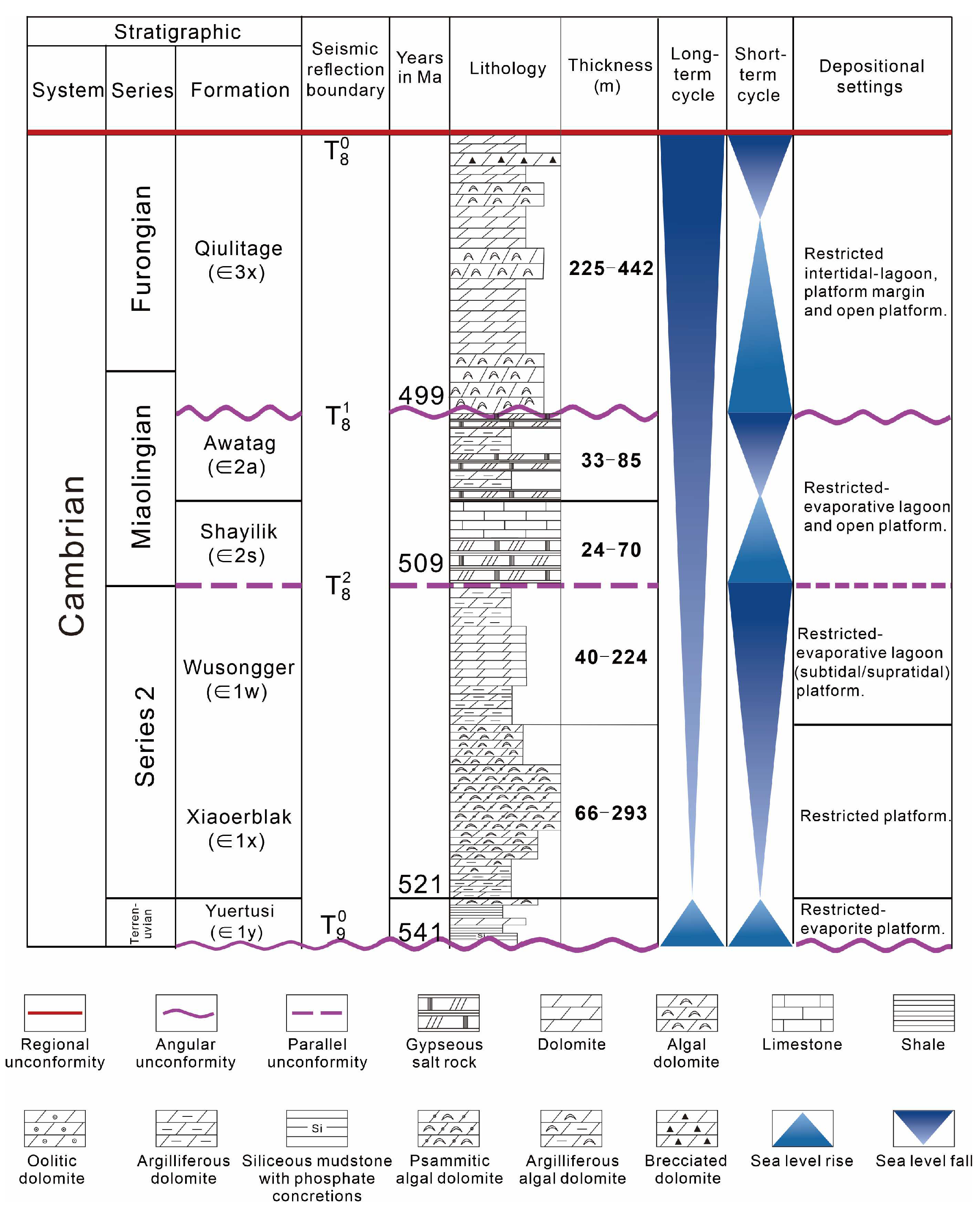
3. Characteristics of Cambrian Lithofacies and Paleogeography
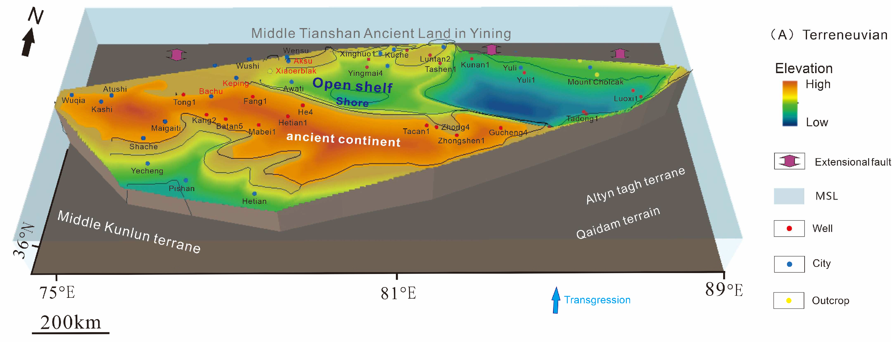
3.1. Terreneuvian
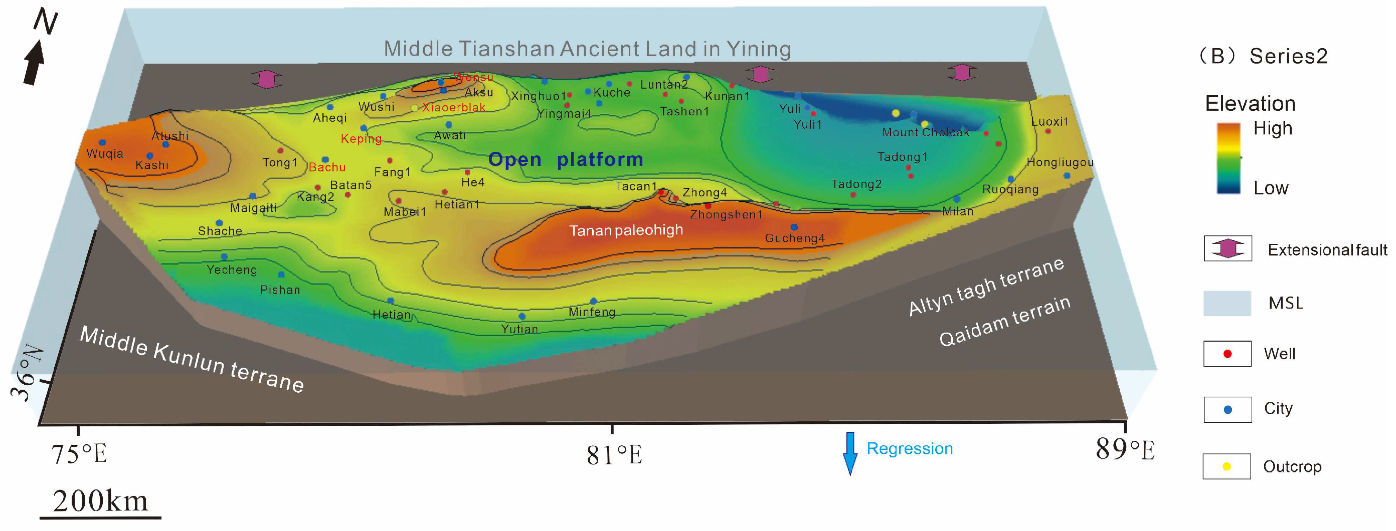
3.2. Series2
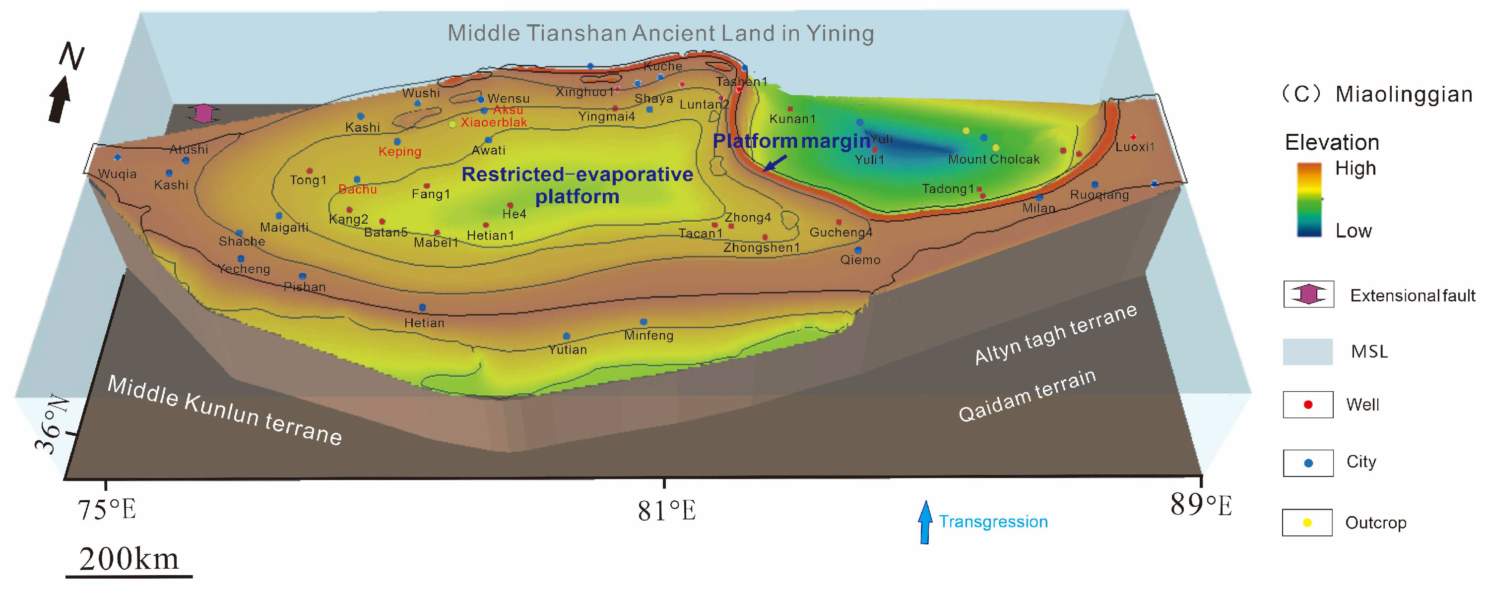
3.3. Miaolingian
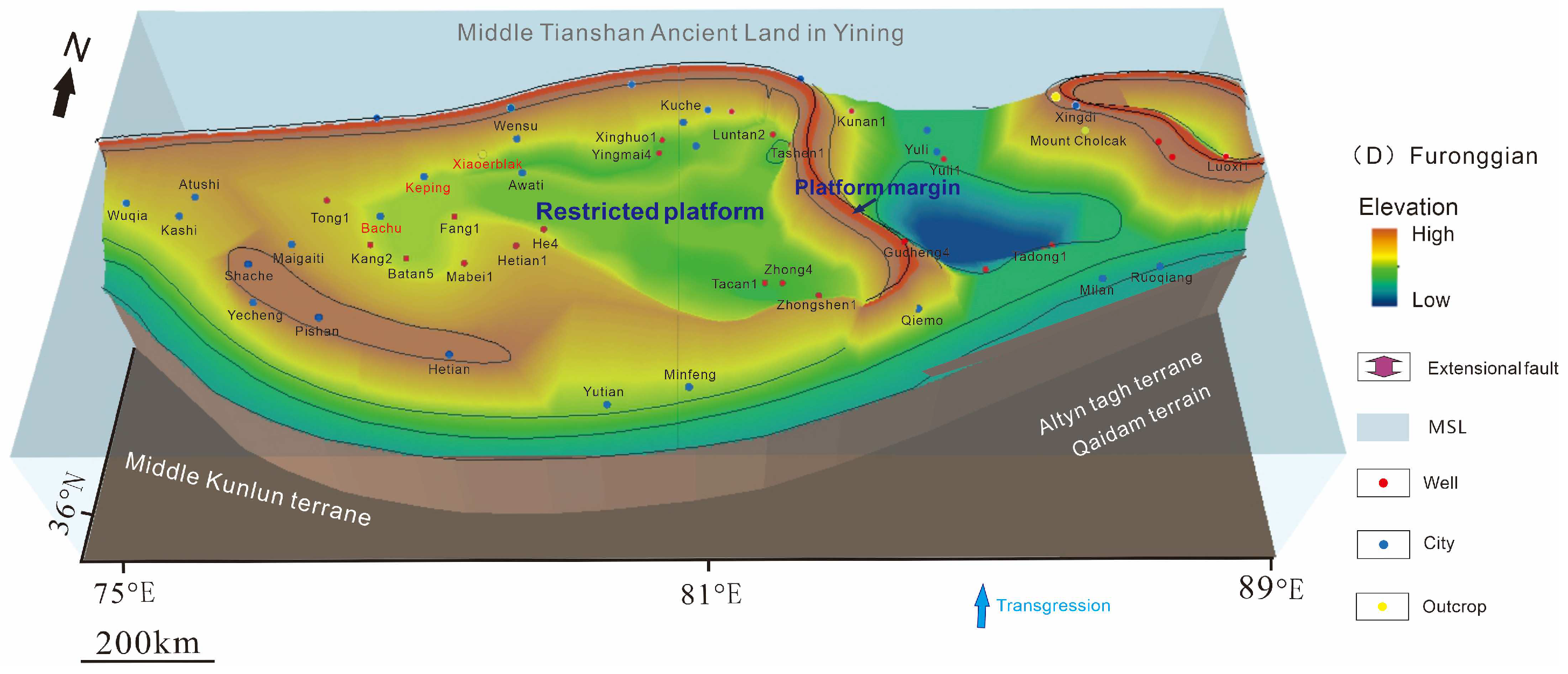
3.4. Furongian
4. Main Controlling Factors of Carbonate Platform Sedimentation
4.1. Tectonism
- 1)
- Regional extension from the Late Neoproterozoic to the Middle Early Cambrian, forming rift valleys, rifting, passive continental slopes, and carbonate platforms.
- 2)
- A regional extension to slight extrusion from Late Cambrian to Early Ordovician, accompanied by the development of carbonate terraces and slopes of the craton.
4.2. Paleoseawater Temperature
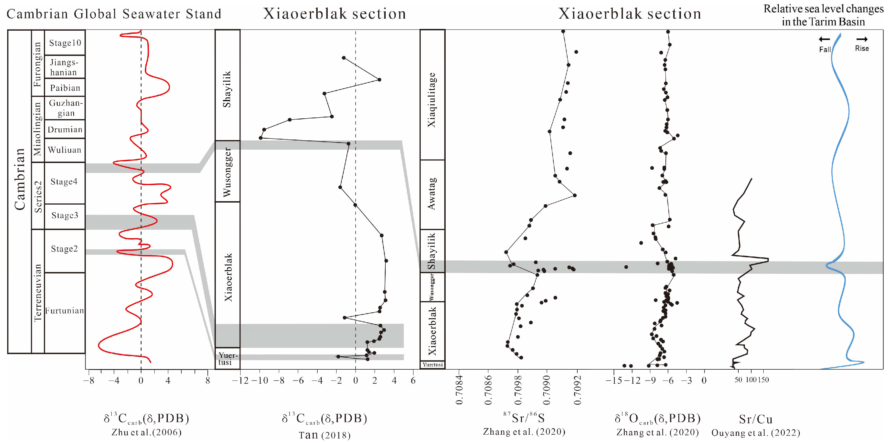
4.3. Relative Sea Level Change
4.4. Oxidation and Reduction Environment
5. Conclusions
- (1)
- The Tarim Basin has gone through the evolution stages of uplift and denudation at the end of the Ediacaran Period, post-rift subsidence, and craton formation in the Early Middle Cambrian, which controlled the transformation of the Tarim Basin from north–south differentiation to the west platform of the east basin, the evolution of gentle slope to the strong rimmed platform, and the distribution and scale of favorable facies in the platform, and developed the muddy rich gentle slope in the sedimentary period of the Yuertus Formation in Terreneuvian, the carbonate gentle slope in the sedimentary period of Series2 Xiaoerblak Formation, the weak rimmed platform of the Wusongger Formation in the sedimentary period, and the strong rimmed evaporation platform of Miaolingian and the weak rimmed platform of Furongian.
- (2)
- Terreneuvian sedimentary framework was mainly controlled by the development of paleo-uplift caused by structure and the change of seawater properties caused by sea level rise and fall. There is an ancient land not submerged by sea water in Bachu-Tazhong area, which is low in the north and high in the south, laying a basic sedimentary environment. The gentle slope carbonate platform is developed in the Keping area, which is in an open marine environment. The rise and fall of sea levels affect the salinity of seawater from low to high. With the rise of a hydrothermal solution, in an anoxic low oxidation environment, the early sediments are jointly controlled by high paleoproductivity and low oxygen exchange, rich in organic matter, and the salinity is maximum at the end. Dolomites are deposited, thus establishing a shallow water sedimentation model.
- (3)
- The Series2 widely developed carbonate platform is mainly controlled by sea level rise and fall. From Terreneuvian to Series2, it experienced transgression, and the internal differentiation was controlled by the new paleogeographic pattern of “three uplifts and two depressions”. During the sedimentary period of the Xiaoerbluk Formation and the Wusongger Formation, the Keping area and the Bachu-Tazhong Uplift shifted from deep-water sediments to restricted platform carbonate rocks. During this period, the relative sea level decreased and progradation strengthened. The shallow water begins to develop the dune beach facies belt and platform edge under the high-energy environment. The terrain is gentle and the terrigenous debris is rich. With the hot and dry climate and gradually increasing salinity, it may play an important role in the development of dolomite.
- (4)
- Under the combined action of rapid accumulation of carbonate rocks, gradual stabilization of global sea level, and the change of paleoclimate from warm and humid to hot and dry, the platform area in the western part of the Tarim Basin changed from a limited platform environment to an evaporation platform environment, and the evaporation lagoon area in Bachu was significantly expanded in the Miaolingian. Under the influence of evaporation, the lithology of the Bachu Uplift belt gradually changed from dark dolomite and red gypsum mudstone to evaporites such as gypsum rock, gypsum salt rock, and salt rock. The Shayilik Formation and the Awatag Formation indicate a strong oxidation environment. The sea level rises, the temperature rises, and the temperature changes from warm and humid to hot and dry. Carbonate rocks in the Bachu–Tazhong area accumulate rapidly, and the water depth becomes shallow, forming evaporation platforms. The lagoon range is significantly expanded, and evaporites such as gypsum rock, gypsum salt rock, and salt rock are developed.
- (5)
- During the sedimentary period of the Lower Qiulitage subgroup in the Furongian, the climate became warm and humid, the relative sea level gradually increased, and the water depth slowly deepened. The basin ended the evaporation lagoon sedimentary environment and developed a limited platform environment again, which generally reflected the sedimentary background of deeper sea water, slower submarine terrain, and smoother communication between seawater and the outside world.
Author Contributions
Funding
Acknowledgments
Conflicts of Interest
References
- Zheng, H.R.; Wu, M.B.; Wu, X.W.; Zhang, T.; Liu, C.Y. Oil-gas exploration prospect of dolomite reservoir in the Lower Paleozoic of Tarim Basin. Acta Pet. Sin. 2007, 28, 1–8. (In Chinese) [Google Scholar]
- Huang, H.P.; Zhang, S.C.; Su, J. Palaeozoic oil-source correlation in the Tarim Basin, NW China: A review. Org. Geochem. 2016, 94, 32–46. [Google Scholar] [CrossRef]
- Cai, C.; Li, K.; Anlai, M.; Zhang, C.; Xu, Z.; Worden, R.H.; Wu, G.; Zhang, B.; Chen, L. Distinguishing Cambrian from Upper Ordovician source rocks: Evidence from sulfur isotopes and biomarkers in the Tarim Basin. Org. Geochem. 2009, 40, 755–768. [Google Scholar] [CrossRef]
- Chang, X.C.; Wang, T.-G.; Li, Q.M.; Cheng, B.; Tao, X.W. Geochemistry and possible origin of petroleum in Palaeozoic reservoirs from Halahatang Depression. J. Asian Earth Sci. 2013, 74, 129–141. [Google Scholar] [CrossRef]
- Li, M.; Wang, T.-G.; Shi, S.; Liu, K.; Ellis, G.S. Benzo[b]naphthothiophenes and alkyl dibenzothiophenes: Molecular tracers for oil migration distances. Mar. Pet. Geol. 2014, 57, 403–417. [Google Scholar] [CrossRef]
- Li, M.; Liu, X.; Wang, T.-G.; Jiang, W.; Fang, R.; Yang, L.; Tang, Y. Fractionation of dibenzofurans during subsurface petroleum migration: Based on molecular dynamics simulation and reservoir geochemistry. Org. Geochem. 2018, 115, 220–232. [Google Scholar] [CrossRef]
- Cheng, B.; Liao, Z.; Wang, T.; Liu, H.; Tian, Y.; Yang, S. Multiple charges to Sinian reservoirs in the middle Sichuan basin, SW China: Insight from the adsorbed/occluded hydrocarbons in solid bitumens. J. Pet. Sci. Eng. 2015, 127, 359–366. [Google Scholar] [CrossRef]
- Jin, Z.; Liu, Q.; Yun, J. Potential petroleum sources and exploration directions around the Manjar Sag in the Tarim Basin. Sci. China Earth Sci. 2016, 60, 235–245. [Google Scholar] [CrossRef]
- Chen, J.; Liu, D.; Hou, X.; Fan, Y.; Jia, W.; Peng, P.; Zhang, B.; Xiao, Z. Origin and evolution of oilfield waters in the Tazhong oilfield, Tarim Basin, China, and their relationship to multiple hydrocarbon charging events. Mar. Pet. Geol. 2018, 98, 554–568. [Google Scholar] [CrossRef]
- Tang, Y.-J.; Li, M.-J.; Fang, R.-H.; Zhang, B.-S.; Yang, Z.; He, D.-X.; Li, M.-R. Geochemistry and origin of Ordovician oils in the Rewapu Block of the Halahatang Oilfield (NW China). Pet. Sci. 2018, 16, 1–13. [Google Scholar] [CrossRef]
- Liu, W.; Zhang, G.Y.; Pan, W.Q.; Deng, S.W.; Li, H.H. Lithofacies palaeogeography and sedimentary evolution of the Cambrian in Tarim area. J. Palaeogeogr. 2011, 13, 529–538. (In Chinese) [Google Scholar]
- Qi, L.X. Oil and gas breakthrough in ultra-deep Ordovician carbonate formations in Shuntuoguole uplift, Tarim Basin. J. China Pet. Explor. 2016, 21, 38–51. (In Chinese) [Google Scholar]
- YOU, X.L.; Sun, S.; Zhu, J.Q.; Li, Q.; Hu, W.X.; Dong, H.L. Microbially mediated dolomite in Cambrian stromatolites from the Tarim Basin, north-west China: Implications for the role of organic substrate on dolomite precipitation. Terra Nova 2013, 25, 387–395. [Google Scholar] [CrossRef]
- YOU, X.L.; Sun, S.; Zhu, J.Q. Significance of fossilized microbes from the Cambrian stromatolites in the Tarim Basin, Northwest China. Sci. China Earth Sci. 2014, 44, 1777–1790. (In Chinese) [Google Scholar]
- YOU, X.L.; Lin, C.S.; Zhu, J.Q.; Tan, J.Y. Primary microbial dolomite precipitation in culture experiments and in stromatolite formations: Implications for the Dolomite Problem. Carpath. J. Earth Environ. 2015, 10, 197–206. [Google Scholar]
- YOU, X.L.; Sun, S.; Lin, C.S.; Zhu, J.Q. Microbial dolomite in the sabkha environment of the middle Cambrian in the Tarim Basin, NW China. Aust. J. Earth Sci. 2018, 65, 109–120. [Google Scholar]
- YOU, X.L.; Jia, W.Q.; Xu, F.; Liu, Y. Mineralogical characteristics of ankerite and mechanisms of primary and secondary origins. J. Earth Sci. China 2018, 43, 4046–4055. [Google Scholar]
- Jia, C.Z.; Pang, X.Q. Research processes and main development directions of deep hydrocarbon geological theories. Acta Pet. Sin. 2015, 36, 1457–1469. [Google Scholar]
- Feng, Z.Z.; Bao, Z.D.; Wu, M.B.; Jin, Z.K.; Shi, X.Z. Lithofacies palaeogeography of the Cambrian in Tarim area. Front. Earth Sci. China 2007, 1, 265–274. [Google Scholar] [CrossRef]
- Zhao, Z.J.; Luo, J.H.; Zhang, Y.B.; Wu, X.N.; Pan, W.Q. Lithofacies paleogeography of Cambrian sequences in the Tarim Basin. Acta Pet. Sin. 2011, 32, 937–948. [Google Scholar]
- Wu, G.H.; Li, H.W.; Xu, Y.L.; Su, W.; Chen, Z.Y.; Zhang, B.S. The tectonothermal events, architecture and evolution of Tarim craton basement paleo-uplifts. Acta Petrol. Sin. 2012, 28, 2435–2452. [Google Scholar]
- Guan, S.W.; Zhang, C.Y.; Ren, R.; Zhang, Y.C.; Wu, L.; Wang, L.; Ma, P.L.; Han, C.W. Early Cambrian syndepositional structural of the northern Tarim Basin and a discussion of Cambrian subsalt and deep exploration. Pet. Explor. Dev. 2019, 46, 1075–1086. [Google Scholar] [CrossRef]
- Zhu, Y.J.; Ni, X.F.; Liu, L.L.; Qiao, Z.F.; Chen, Y.Q.; Zheng, J.F. Depositional differentiation and reservoir potential and distribution of ramp systems during post-rift period: An example from the Lower Cambrian Xiaoerbulake Formation in the Tarim Basin, NW China. Acta Sedimentol. Sin. 2019, 37, 1044–1057. [Google Scholar]
- Cao, Y.H.; Wang, S.; Zhang, Y.J.; Yang, M.; Yan, L.; Zhao, Y.M.; Zhang, J.L.; Wang, X.D.; Zhou, X.X.; Wang, H.J. Petroleum geological conditions and exploration potential of Lower Paleozoic carbonate rocks in Gucheng Area, Tarim Basin, China. Pet. Explor. Dev. 2019, 46, 1099–1114. [Google Scholar] [CrossRef]
- Zhang, G.Y.; Liu, W.; Zhang, L.; Yu, B.S.; Li, H.H.; Zhang, B.M.; Wang, L.D. Cambrian-Ordovician prototypic basin, paleogeography and petroleum of Tarim Craton. Earth Sci. Front. 2015, 22, 269–276. [Google Scholar]
- Gao, H.H.; He, D.F.; Tong, X.G.; Wen, Z.X.; Wang, Z.M. Tectonic depositional Environment and Proto-type Basin Evolution of the Cambrian in the Tarim Basin. Geoscience 2017, 31, 102. [Google Scholar]
- Wei, G.Q.; Zhu, Y.J.; Zheng, J.F.; Yu, G.; Ni, X.F.; Yan, L.; Tian, L.; Huang, L.L. Tectonic-lithofacies paleogeography, large-scale source-reservoir distribution and exploration zones of Cambrian subsalt formation, Tarim Basin, NW China. Pet. Explor. Dev. 2021, 48, 1289–1303. [Google Scholar]
- Xiao, Z.H.; Wang, Z.M.; Jiang, R.Q.; Wu, J.C.; Zhang, L.J. Sequence stratigraphic features of the Cambrian carbonate rocks in the Tarim Basin. Oil Gas Geol. 2011, 32, 1–16. [Google Scholar]
- Zheng, J.F.; Zhu, Y.J.; Huang, L.L.; Yang, G.; Hu, F.J. Geochemical Characteristics and Their Geological Significance of Lower Cambrian Xiaoerblak Formation in Northwestern Tarim Basin, China. Minerals 2022, 12, 781. [Google Scholar]
- Zheng, J.F.; Pan, W.Q.; Shen, A.J.; Yuan, W.F.; Huang, L.L.; Ni, X.F.; Zhu, Y.J. Reservoir geological modeling and significance of Cambrian Xiaoerblak Formation in Keping outcrop area, Tarim Basin, NW China. Pet. Explor. Dev. 2020, 47, 536–547. [Google Scholar]
- Fan, Q.; Fan, T.L.; Li, Y.F.; Zhang, J.P.; Gao, Z.Q.; Chen, Y. Paleo-Environments and Development Pattern of High-Quality Marine Source Rocks of the Early Cambrian, Northern Tarim Platform. Earth Sci. 2020, 45, 285–302. [Google Scholar]
- Ouyang, S.Q.; Lyu, X.X.; Xue, N.; Li, F.; Wang, R. Paleoenvironmental characteristics and source rock development model of the Early-Middle Cambrian: A case of the Keping-Bachu area in the Tarim Basin. J. China Univ. Min. Technol. 2022, 51, 293–310. [Google Scholar]
- Tang, L.J. Major evolutionary stages of Tarim Basin in Phanerozoic Time. Earth Sci. Front 1997, 4, 318–324. [Google Scholar]
- Lin, C.S.; Yang, H.J.; Liu, J.Y.; Peng, L.; Cai, Z.Z.; Yang, X.F.; Yang, Y.H. Paleostructural geomorphology of the Paleozoic central uplift belt and its constraint on the development of depositional facies in the Tarim Basin. Sci. China Ser. D Earth Sci. 2009, 52, 823–834. [Google Scholar] [CrossRef]
- Huang, Y.; Fan, T.L.; Berra, F. Architecture and paleogeography of the Early Paleozoic carbonate systems in the east-central Tarim Basin (China): Constraints from seismic and well data. Mar. Pet. Geol. 2020, 113, 104147. [Google Scholar]
- He, B.; Jiao, C.; Xu, Z.; Cai, Z.; Zhang, J.; Li, H.; Chen, W.; Yu, Z. The paleotectonicand paleogeography reconstructions of the Tarim Basin and its adjacent areas (NWChina) during the late Early and Middle Paleozoic. Gondwana Res. 2016, 30, 191–206. [Google Scholar] [CrossRef]
- Ngia, N.R.; Hu, M.Y.; Gao, D. Tectonic and geothermal controls on dolomitization and dolomitizing fluid flows in the Cambrian-Lower Ordovician carbonate successions in the western and central Tarim Basin, NW China. J. Asian Earth Sci. 2019, 172, 359–382. [Google Scholar]
- Gao, Z.Q.; Fan, T.L. Intra-platform tectono-sedimentary response to geodynamic transition along the margin of the Tarim Basin, NW China. J. Asian Earth Sci. 2014, 96, 178–193. [Google Scholar]
- Zhang, J.; Hu, W.; Qian, Y.; Wang, X.; Cao, J.; Zhu, J.; Li, Q.; Xie, X. Formation of saddle dolomites in Upper Cambrian carbonates, western Tarim basin (northwest China): Implications for fault-related fluid flow. Mar. Pet. Geol. 2009, 26, 1428–1440. [Google Scholar] [CrossRef]
- Jin, Z.; Zhu, D.; Hu, W.; Zhang, X.; Zhang, J.; Song, Y. Mesogenetic dissolution of the middle Ordovician limestone in the Tahe oilfield of Tarim basin, NW China. Mar. Pet. Geol. 2009, 26, 753–763. [Google Scholar] [CrossRef]
- Wang, K.; Liu, W.; Huang, Q.Y.; Shi, S.Y.; Ma, K.; Liang, D.X. Development characteristics and evolution of the cambrian sedimentary system in Tazhong and gucheng area. Tarim Basin. Geol. Sci. Technol. Inf. 2015, 34, 116–124. (In Chinese) [Google Scholar]
- Liu, W.; Shen, A.J.; Liu, G.D.; Zheng, X.P.; Chen, Y.N.; Zhang, Y. Characteristics and exploration domains of lower paleozoic carbonate reservoirs in eastern Tarim basin. Mar. Ori. Petrol. Geol. 2016, 21, 1–12. (In Chinese) [Google Scholar]
- Zhang, Y.G.; Yang, T.; Hohl, S.V.; Zhu, B.; He, T.C.; Pan, W.Q.; Chen, Y.Q.; Yao, X.Z.; Jiang, S.Y. Seawater carbon and strontium isotope variations through the late Ediacaran to late Cambrian in the Tarim Basin. Precambrian Res. 2020, 345, 105769. [Google Scholar] [CrossRef]
- Jin, Z.M.; Tan, X.C.; Tang, H.; Shen, A.J.; Qiao, Z.F.; Zheng, J.F.; Li, F.; Zhang, S.X.; Chen, L.; Zhou, C.G. Sedimentary environment and petrological features of organic-rich fine sediments in shallow water overlapping deposits: A case study of Cambrian Yuertus Formation in northwestern Tarim Basin, NW China. Pet. Explor. Dev. 2020, 47, 513–526. [Google Scholar] [CrossRef]
- Zhou, Z.Y.; Zhao, Z.X.; Hu, Z.X. Stratigraphy of Tarim Basin; Science Press: Beijing, China, 2001; pp. 1–359. [Google Scholar]
- Zhu, Y.J.; Shen, A.J.; Liu, L.L.; Chen, Y.Q.; Yu, G. Tectonic-sedimentary filling history through the Later Sinian to the Mid-Cambrian in Tarim Basin and its explorational potentical. Acta Sedimentol. Sin. 2020, 38, 398–410. [Google Scholar]
- Gao, Z.Q.; Fan, T.L. Carbonate platform-margin architecture and its influence on Cambrian-Ordovician reef-shoal development, Tarim Basin, NW China. Mar. Pet. Geol. 2015, 68, 291–306. [Google Scholar] [CrossRef]
- Zhang, Z.Y.; Zhu, G.Y.; Zhang, Y.J.; Han, J.F.; Li, T.T.; Wang, E.; Greenwood, P. The origin and accumulation of multi-phase reservoirs in the east Tabei uplift, Tarim Basin, China. Mar. Pet. Geol. 2018, 98, 533–553. [Google Scholar] [CrossRef]
- Jiang, W.; Gao, Z.Q.; Hu, Z.Q.; Chu, C.L. Sedimentary Filling Evolution and Hydrocarbon Control of High Frequency Sequence in Yurtus Formation, Tarim Basin. Geoscience 2021, 35, 349–364. [Google Scholar]
- Xie, L. Study of Marine Carbonate Source Rocks in the Lower Paleozoic: The Lower Cambrian Xiaoerbulake Formation in Tarim basin. Master’s Thesis, China University of Petroleum, Beijing, China, 2016. [Google Scholar]
- Fan, Q.Q.; Lu, S.F.; Li, W.H.; Pan, W.Q.; Zhang, B.S.; Zhang, Y.Y.; Tan, Z.Z. Geochemical characteristics and geological significance for petroleum of the Middle-Lower Cambrian marine strata: A case study of Keping area in the Tarim basin. J. China Univ. Min. Technol. 2019, 48, 377–394. [Google Scholar]
- Ren, Y.G.; Zhang, J.L.; Qi, J.S.; Zhang, Y.J.; Zhang, B.; Liu, Y. Sedimentary characteristics and evolution laws of cambrian-ordovician carbonate rocks in Tadong region. Pet. Geol. Oilfield Dev. Daqing 2014, 33, 103–110. (In Chinese) [Google Scholar]
- Wang, G.; Fan, T.L.; Liu, H.H. Characteristics and evolution of ordovician carbonate platform marginal facies in tazhong-gucheng area. Tarim Basin. Geoscience 2014, 28, 995–1007. (In Chinese) [Google Scholar]
- Xu, X.S.; Wang, Z.J.; Wan, F.; Fu, H. Tecotonic paleogeographic evolution and source rocks of the early paleozoic in the Tarim Basin. Earth Sci. Front. 2005, 12, 49–57. (In Chinese) [Google Scholar]
- Lin, C.S.; Li, S.T.; Liu, J.Y.; Qian, Y.X.; Luo, H.; Chen, J.Q.; Peng, L.; Rui, Z.F. Tectonic framework and paleogeographic evolution of the Tarim basin during the Paleozoic major evolutionary stages. Acta Petrol. Sin. 2011, 27, 210–218. (In Chinese) [Google Scholar]
- Wang, Q.; Li, S.Z.; Zhao, S.J.; Mu, D.L.; Guo, R.H.; Somerville, I. Early paleozoic Tarim Orocline: Insights from paleogeography and tectonic evolution in the Tarim. Basin Geol. J. 2017, 52, 436–448. [Google Scholar] [CrossRef]
- Li, S.; Yang, Z.; Zhao, S.; Li, X.; Guo, L.; Yu, S.; Liu, X.; Suo, Y.; Lan, H. Global Early Paleozoic orogens (I): Collision-type orogeny. J. Jilin Univ. Earth Sci. Ed. 2016, 46, 945–967. (In Chinese) [Google Scholar]
- Li, S.; Zhao, S.; Liu, X.; Cao, H.; Yu, S.; Li, X.; Somerville, I.; Yu, S.; Suo, Y. Closure of the Proto-Tethys Ocean and Early Paleozoic amalgamation of microcontinental blocks in East Asia. Earth-Sci. Rev. 2018, 186, 37–75. [Google Scholar] [CrossRef]
- Jia, C.Z.; Zhang, S.B.; Wu, S.Z. Stratigraphy of the Tarim Basin and Adjacent Areas; Science Press: Beijing, China, 2004; pp. 1–450. [Google Scholar]
- He, D.F. Cenozoic tectonic evolution and oil-gas accumulation in Tarim basin. Pet. Explor. Dev. 1994, 21, 1–8. [Google Scholar]
- He, D.F.; Jia, C.Z.; Li, D.S.; Zhang, C.J.; Meng, Q.R.; Shi, X. Formation and evolution of polycyclic superimposed Tarim Basin. Oil Gas Geol. 2005, 26, 64–77. [Google Scholar]
- Feng, Z.Z.; Peng, Y.M.; Jin, Z.L.; Bao, Z.D. Lithofacies palaeogeography of the early Cambrian in China. J. Palaeogeogr. 2002, 4, 1–12. [Google Scholar]
- Liu, P.X.; Guan, P.; Feng, F.; Jia, W.B.; Zhang, W.; Deng, S.B.; Jin, Y.Q. Evolution of Cambrian Sedimentary Environment and Ocean-Land Coupling of the Western Tarim Carbonate Platform. Acta Sedimentol. Sin. 2016, 34, 1092–1107. [Google Scholar]
- Lan, X.D.; Lü, X.X.; Zhu, Y.M.; Yu, H.F. The geometry and origin of strike-slip faults cutting the Tazhong low rise megaanticline (central uplift, Tarim Basin, China) and their control on hydrocarbon distribution in carbonate reservoirs. J. Nat. Gas Sci. Eng. 2015, 22, 633–645. [Google Scholar] [CrossRef]
- Li, S.; Yang, Z.; Zhao, S.; Li, X.; Suo, Y.; Guo, L.; Yu, S.; Dai, L.; Li, S.; Mu, D. Global Early Paleozoic orogens (II): Subduction-accretionary-type orogeny. J. Jilin Univ. Earth Sci. Ed. 2016, 46, 968–1004. (In Chinese) [Google Scholar]
- Li, S.; Yang, Z.; Yang, Z.; Zhao, S.; Liu, X.; Yu, S.; Li, X.; Guo, L.; Suo, Y.; Dai, L.; et al. Global Early Paleozoic (IV): Plate reconstruction and supercontinent Carolina. J. Jilin Univ. Earth Sci. Ed. 2016, 46, 1026–1041. (In Chinese) [Google Scholar]
- Li, S.; Zhao, S.; Li, X.; Cao, H.-H.; Liu, X.; Guo, X.; Xiao, W.; Lai, S.; Yan, Z.; Li, Z.; et al. Tethys Ocean in East Asian (I): Northern and southern border faults and subduction polarity. Acta Petrol. Sin. 2016, 32, 2609–2627. (In Chinese) [Google Scholar]
- Li, S.Z.; Zhao, S.J.; Yu, S.; Cao, H.H.; Li, X.Y.; Liu, X.; Guo, X.; Xiao, W.; Lai, S.; Yan, Z.; et al. Proto-Tethys Ocean in east Asian (II): Affinity and assembly of Early Paleozoic micro-continental blocks. Acta Petrol. Sin. 2016, 32, 2628–2644. (In Chinese) [Google Scholar]
- Liu, H.; Somerville, I.D.; Lin, C.S.; Zuo, S.J. Distribution of Palaeozoic tectonic superimposed unconformities in the Tarim Basin, NW China: Significance for the evolution of palaeogeomorphology and sedimentary response. Geol. J. 2016, 51, 627–651. [Google Scholar]
- Shao, L.Y.; Dou, J.W.; Zhang, P.F. Paleogeographic Significances of Carbon and Oxygen Isotopes in late Permian Rocks of Southwest China. Geochimica 1998, 06, 575–581. [Google Scholar]
- Mei, M.X.; Ma, Y.S.; Zhang, H.; Meng, X.Q.; Chen, Y.H. From Basin Black Shales to Platform Carbonate Rocks: A Study on Sequence Stratigraphy for the Lower Cambrian of the Upper-Yangtze Region in South China. Acta Geol. Sin. Engl. Ed. 2007, 81, 739–755. [Google Scholar]
- Zuo, J.X.; Peng, S.C.; Qi, Y.P.; Zhu, X.J.; Bagnoli, G.; Fang, H.B. Carbon-Isotope Excursions Recorded in the Cambrian System, South China: Implications for Mass Extinctions and Sea-Level Fluctuations. J. Earth Sci. 2018, 29, 479–491. [Google Scholar]
- Song, Y.F.; Chen, D.Z.; Guo, C.; Zhou, X.Q. Depositional Characteristics of Microbial Carbonates from the Lower Xiaoerbulak Formation in the Xiaoerbulake Section, Tarim Basin. Acta Sedimentol. Sin. 2020, 38, 55–63. [Google Scholar]
- Fang, Y.H.; Xu, H.F. Dissolved silica-catalyzed disordered dolomite precipitation. Am. Mineral. 2022, 107, 443–452. [Google Scholar] [CrossRef]
- Fang, Y.H.; Xu, H.F. Coupled dolomite and silica precipitation from continental weathering during deglaciation of the Marinoan Snowball Earth. Precambrian Res. 2022, 380, 106824. [Google Scholar] [CrossRef]
- Jing, S. Lithic Facies and Geochemical Characteristics of Cambrian Dolomite in the Bachu Uplift Belt, Tarim Basin. Master’s Thesis, Xi’an Shiyou University, Xi’an, China, 2020. [Google Scholar]
- Tan, Z.Z. Depositional environment and controlling factors of Cambrian-Ordovician marine carbonate in the Tarim Basin. Master’s Thesis, China University of Petroleum (East China), Qingdao, China, 2018. [Google Scholar]
- Zhu, M.Y.; Babcock, L.E.; Peng, S.C. Advances in Cambrian stratigraphy and paleontology: Integrating correlation techniques, paleobiology, taphonomy and paleoenvironmental reconstruction. Palaeoworld 2006, 15, 217–222. [Google Scholar]


Disclaimer/Publisher’s Note: The statements, opinions and data contained in all publications are solely those of the individual author(s) and contributor(s) and not of MDPI and/or the editor(s). MDPI and/or the editor(s) disclaim responsibility for any injury to people or property resulting from any ideas, methods, instructions or products referred to in the content. |
© 2023 by the authors. Licensee MDPI, Basel, Switzerland. This article is an open access article distributed under the terms and conditions of the Creative Commons Attribution (CC BY) license (https://creativecommons.org/licenses/by/4.0/).
Share and Cite
Zhang, K.; YOU, X.; Wu, Y.; Zhao, Y.; Wang, J. The Main Controlling Factors on the Evolution of the Cambrian Carbonate Platform in the Tarim Basin and Its Implications for the Distribution of Ultra-Deep Dolomite Reservoirs. Minerals 2023, 13, 245. https://doi.org/10.3390/min13020245
Zhang K, YOU X, Wu Y, Zhao Y, Wang J. The Main Controlling Factors on the Evolution of the Cambrian Carbonate Platform in the Tarim Basin and Its Implications for the Distribution of Ultra-Deep Dolomite Reservoirs. Minerals. 2023; 13(2):245. https://doi.org/10.3390/min13020245
Chicago/Turabian StyleZhang, Kehui, Xuelian YOU, Yifen Wu, Yijing Zhao, and Jia Wang. 2023. "The Main Controlling Factors on the Evolution of the Cambrian Carbonate Platform in the Tarim Basin and Its Implications for the Distribution of Ultra-Deep Dolomite Reservoirs" Minerals 13, no. 2: 245. https://doi.org/10.3390/min13020245
APA StyleZhang, K., YOU, X., Wu, Y., Zhao, Y., & Wang, J. (2023). The Main Controlling Factors on the Evolution of the Cambrian Carbonate Platform in the Tarim Basin and Its Implications for the Distribution of Ultra-Deep Dolomite Reservoirs. Minerals, 13(2), 245. https://doi.org/10.3390/min13020245