Article

Impact of the Regional Pai-Khoi-Altai Strike-Slip Zone on the Localization of Hydrocarbon Fields in Pre-Jurassic Units of West Siberia

Geophysics Department, Saint Petersburg Mining University, St. Petersburg 199106, Russia
*
Author to whom correspondence should be addressed.
Minerals 2023, 13(12), 1511; https://doi.org/10.3390/min13121511
Submission received: 6 October 2023 / Revised: 27 November 2023 / Accepted: 28 November 2023 / Published: 30 November 2023

Abstract

:
The paper presents the results of a geological interpretation using gravity, magnetic, and seismic data to understand the oil and gas potential of pre-Jurassic sedimentary intervals and basement in the central West Siberia basin. The 200 km long Pai-Khoi-Altai strike-slip zone was investigated. Reconstruction based on a data complex indicate the right-lateral kinematics of the principal strike-slip faults and possible fault inversion. The study evaluated the spatial and genetic relationship between the conditions for hydrocarbon trap development and the strike-slip fault systems, such as “flower structures”. Strike-slip geometry and kinematics are confirmed based on 2D and 3D seismic data. Geological and geophysical criteria are used to forecast localization of hydrocarbon fields. Predictive zones are elongated in several different directions and have a different distribution pattern in the blocks separated by principal strike-slip faults, confirming its significance as a controlling factor for the hydrocarbon potential of the region’s structures.

Graphical Abstract

1. Introduction

The West Siberia basin provides approximately 70% of Russia’s oil production and over 90% of its gas production [1]. The region is characterized by intensive exploitation at a depth of 2–4 km, consisting of Jurassic and Cretaceous deposits covered by younger sediments. This well-studied interval is gradually depleting, with experts noting a declining trend in oil and gas reserves, while there is no anticipated decrease in demand for petroleum products [2,3].
Relatively less explored but still petroleum- and gas-bearing are the pre-Jurassic strata, including the so-called “intermediate structural layer” and the weathered crust of the consolidated basement. According to various estimates, 3 to 15% of the world’s proven oil reserves are localized in the basement rocks. However, the volume of exploratory drilling to reach this level is an order of magnitude less than in the sedimentary cover, and the discovery of deposits of this type often happens by chance [4].
In the pre-Jurassic complex of Western Siberia, deposits have been identified at dozens of fields with oil reserves of about 0.2 billion tons (for comparison, current recoverable reserves from all horizons of Western Siberia are nearly 18 billion tons) [5,6]. The prospects for new discoveries in such deposits are significant, and the pre-Jurassic complex deposits are considered to be the principal source for locating large reserves in the Western Siberia region [7].
The West Siberia petroleum and gas basin is of interest to leading Russian geologists such as V.S. Surkov [8], who described the structure of the Western Siberia basement, and A.E. Kontorovich [9], who studied the oil and gas potential of the region. G.A. Lobova [10] wondered about the oil and gas content of the pre-Jurassic rock, A.I. Timurziev [4,11] described fault structure, S.F. Khafizov [12] assessed the hydrocarbon potential of the province, which made a great contribution to the study of the area. While the prospects for discovering oil deposits in the basement rocks of the West Siberia petroleum and gas province are highly rated, the factors controlling the formation of deposits in pre-Jurassic-age rocks are relatively poorly understood to date [13]. This is likely the reason for the lack of new discoveries at deep horizons in the sedimentary cover, in the “intermediate structural layer,” and in the upper part of the basement.
According to the results of scientific research [10,12,14], the localization of hydrocarbon deposits in pre-Jurassic complex rocks is influenced by the following:
  • The presence, thickness, and composition of “intermediate structural layer” rocks, including the availability of source rocks.
  • The development of regional strike-slip dislocations, which create extensive zones of deformation and increased fracturing in the overlying sedimentary cover, controlled by “flower structures” [14].
  • Triassic rifting and the development of volcanic–sedimentary deposits.
  • The presence of uplifted basement surface features.
  • The development of weathered crusts in the basement.
However, oil and gas extraction from crystalline basement rocks presents significant challenges and risks. These risks include geological complexities, such as fractured and heterogeneous formations, potential for induced seismicity, and difficulties in wellbore stability. In part, the risk is associated with the proximity and activity of faults.
Our study examines the deep structural characteristics and the impact on the hydrocarbon potential of the Pai-Khoi-Altai strike-slip zone region. The purpose of the work is to confirm the presence of a strike-slip zone at the test site using a set of geophysical data and to assess its possible impact on oil and gas potential.
The significance of strike-slip dislocations in predicting oil and gas deposits has been noted by researchers such as G.G. Gogonenkov [15], N.V. Nassonova [16], A.I. Timurziev [11], O.A. Smirnov [17], V.P. Igoshkin [18], V.S. Surkov [19], and others. The manifestation of strike-slip tectonics in the West Siberia sedimentary basin has been identified at both regional levels (based on potential field data and 2D seismic surveys) and large-scale levels (based on 3D seismic surveys). Such structures are often complex in structure and have low amplitude, so their identification requires special processing of seismic data, a good example of which is spectral decomposition of data [20,21]. It has been established that strike-slip movement appears in the form of echelon folds, duplex faults (in plan view) and “flower structures” (in cross-section). Publications mention the influence of the “piston” effect [16], which pressurizes fluids and operates during compression and extension, as well as the formation of “pull-apart” basins [11,22] with developed sedimentary units and the formation of curtain folds and faults, complicating the structural framework of the deposits.
In the current work, using one specific area as an example, we examine the relationship between the formation of deep oil and gas deposits and the positions of principal strike-slip and splaying faults. We started with the assumption that strike-slip zones largely control the formation of fluid-permeable zones within the areas of main and splaying faults. The study area chosen for research is located in the central part of the West Siberia petroleum and gas province and includes map sheets P-43 and P-44, which are intersected by the regional Pai-Khoi-Altai strike-slip zone from southeast to northwest (see Figure 1) [23].
Research has revealed that the Hercynian folded basement has a heterogeneous composition, consisting of metamorphic and variably metamorphosed sedimentary rocks (clay shales, ortho- and metashales, and carbonate rocks) that have been disrupted by intrusions of both acidic and mafic composition. During the Early Mesozoic, uplift movements predominated over a large part of the area, resulting in significant erosion of the pre-Mesozoic strata and the formation of extensive weathering crusts. In the Early Triassic, rift zones began to form and develop, which were filled with sedimentary–volcanogenic deposits. The accumulation of rocks was accompanied by folding and the development of faulted (including strike-slip) dislocations, driven by stresses along the boundaries of adjacent folded areas. Simultaneously with the deepening of rift basins, there were multiple shifts between basin and continental facies [24]. A marine regime was established in most of the region during the Late Jurassic, coinciding with the deposition of sandy–silt–clay sediments. At the end of the Jurassic period, carbonate-rich and bituminous clay silts were deposited in the marine basin [25,26]. During the same period, active movements occurred along the regional Pai-Khoi-Altai strike-slip zone.

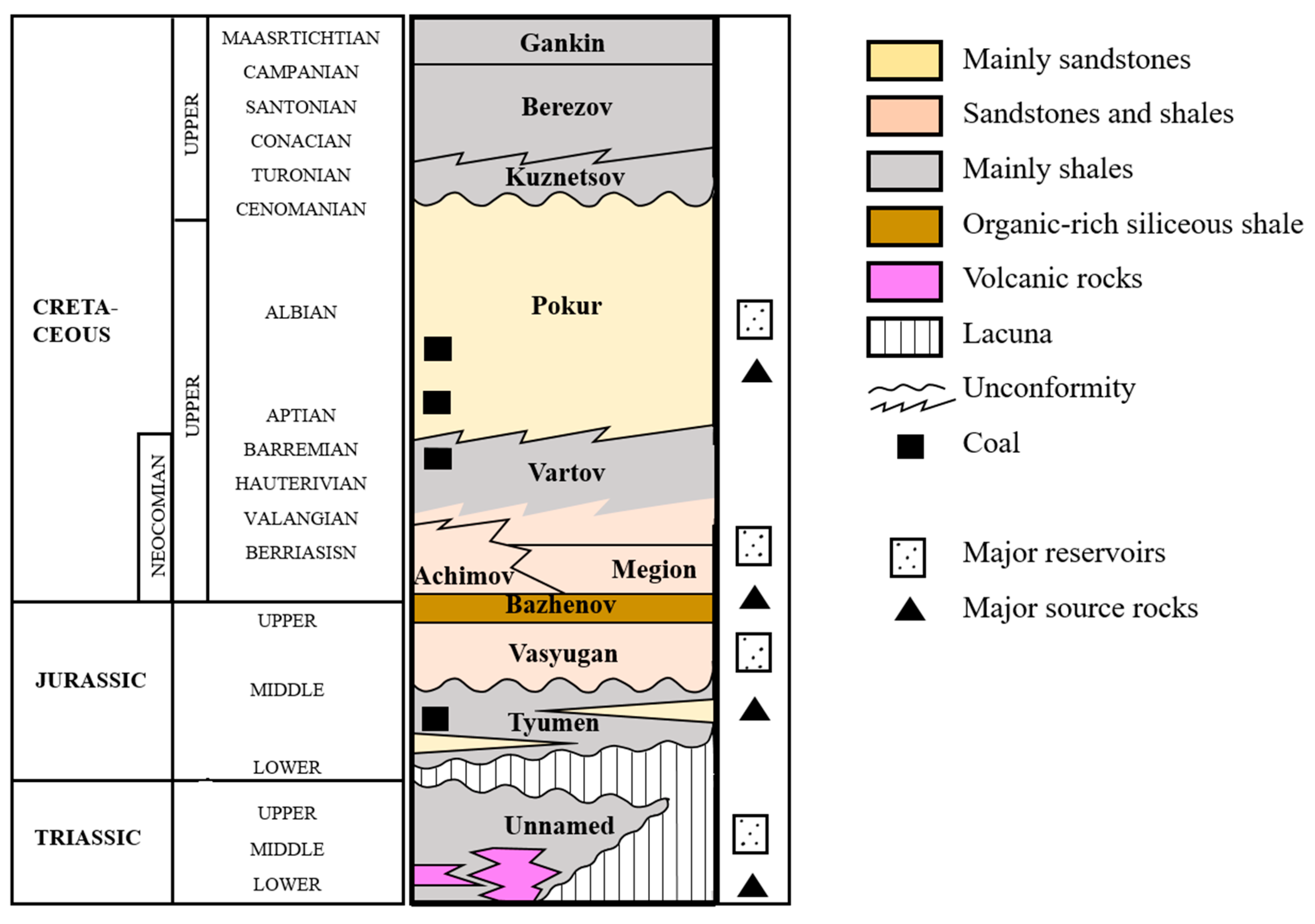
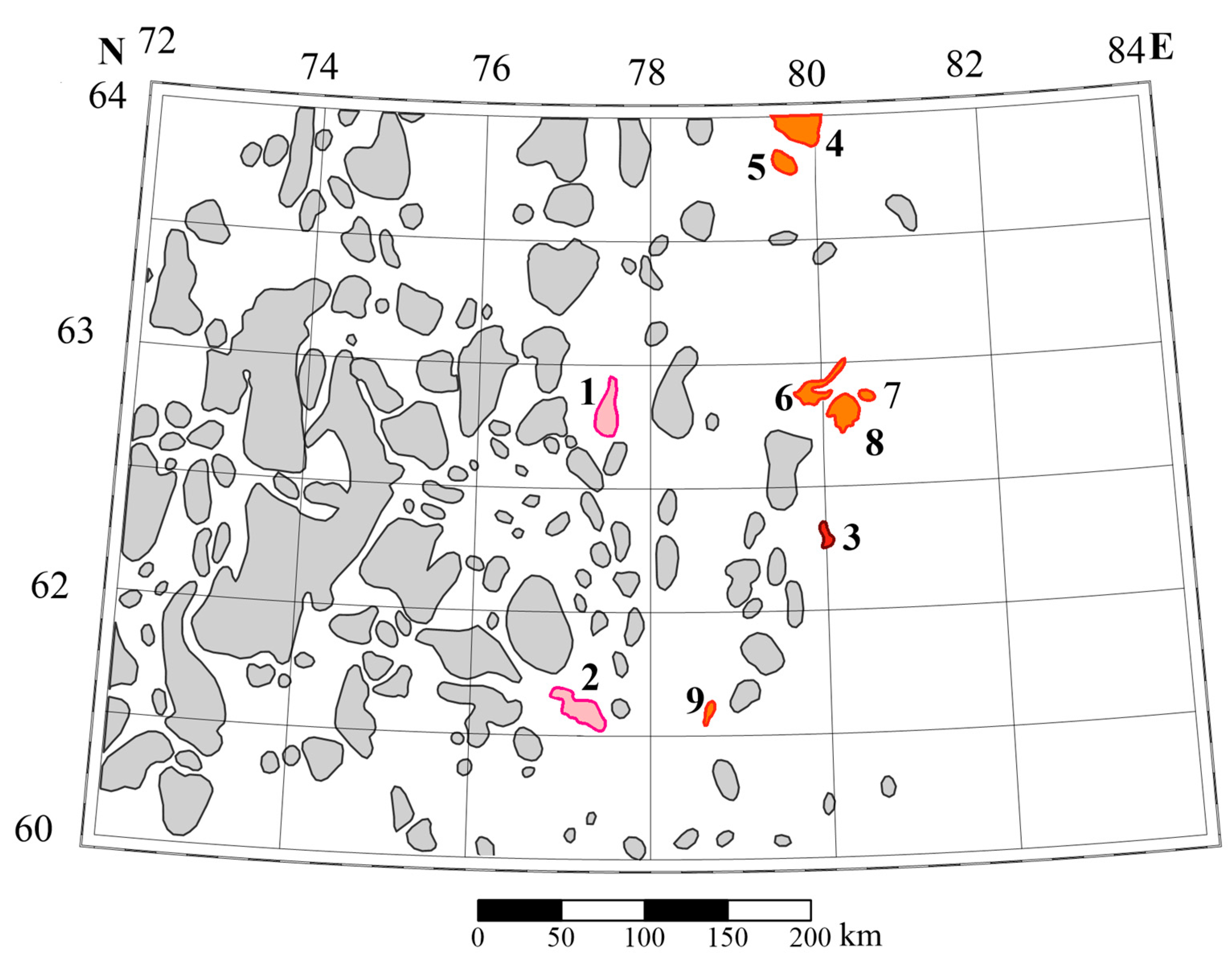
2. Hydrocarbon Potential of the Pre-Jurassic Units in the Study Area

Within the considered area, several hydrocarbon-bearing complexes (HBC) are distinguished: the pre-Jurassic (mainly Paleozoic), Jurassic (Tyumen, Vasyugan and Bazhenov), boundary time interval (Upper Jurassic to Lower Cretaceous), and Lower Cretaceous (Figure 2). Most of them are terrigenous (sandstone), but there are accumulations of hydrocarbons in the tops of the Triassic volcanic rocks where their porosity reaches 15%. The major source rocks are unnamed Triassic organic-rich sediments; Togur-Tyumen formation (J1-2) (coals in shales and sandstones); Bazhenov (J3-K1) organic-rich siliceous shale; and Pokur formation (K1-2). In the Caledonian part of the study area, there is a hydrocarbon-bearing “intermediate structural layer” (ISL) located between the consolidated basement and the platform cover. This layer is primarily composed of Late Paleozoic sediments and weathering crusts, partially re-deposited, with zones of organic matter (OM) generation [17,27]. This complex is poorly studied over most of the area due to its deep burial, and it has only been encountered in a limited number of wells.
In Paleozoic rocks, the following oil deposits have been explored and studied (Figure 3): Severo-Varieganskoye field, where oil accumulations are found in fractured volcanites and shales, as well as in their weathering crusts. Their structure is poorly studied [24].
The Sovetskoye field, reservoir M1 (Paleozoic), consists of loose weathered volcanites of the basic composition and fractured organogenic limestones. The pre-Jurassic HBC here is encountered in five wells at depths ranging from 2702 to 2776 m. Commercial oil flow is obtained from weathered fractured limestones [24].
The Kotygyeganskoye field (Vasyuganskaya oil- and gas-bearing region) is where the oil reservoir is located in fractured–cavernous Paleozoic collectors represented by dolomite breccia [25].
Several fields have oil reservoirs in pre-Jurassic rocks, including the unique Kharampur field, large fields like Bakhilovskoye, Varyngskoye, Verkhnekolik-Eganskoye, as well as the medium-sized and small Festivalnoye and Severnoye fields [25].
The thickness of the intermediate layer, based on the limited number of wells studied, is estimated to be highly variable, averaging several hundred meters [28,29]. Due to its strong metamorphism, ISL was not considered a promising target for oil exploration until the 1970s. However, subsequent assessments have shown that the ISL, in terms of sedimentary fill volumes, is “comparable to the volume of the Mesozoic-Cenozoic cover of the plate” and could be a significant source of organic matter [30]. High prospects for oil and gas in the actual intermediate structural layer are estimated [10] based on the study of oils, bitumens, and organic matter dispersed in rocks and underground waters [31]. Moreover, organic matter could have migrated into overlying horizons through subvertical fluid-permeable zones formed by strike-slips in an anoxic environment [32].

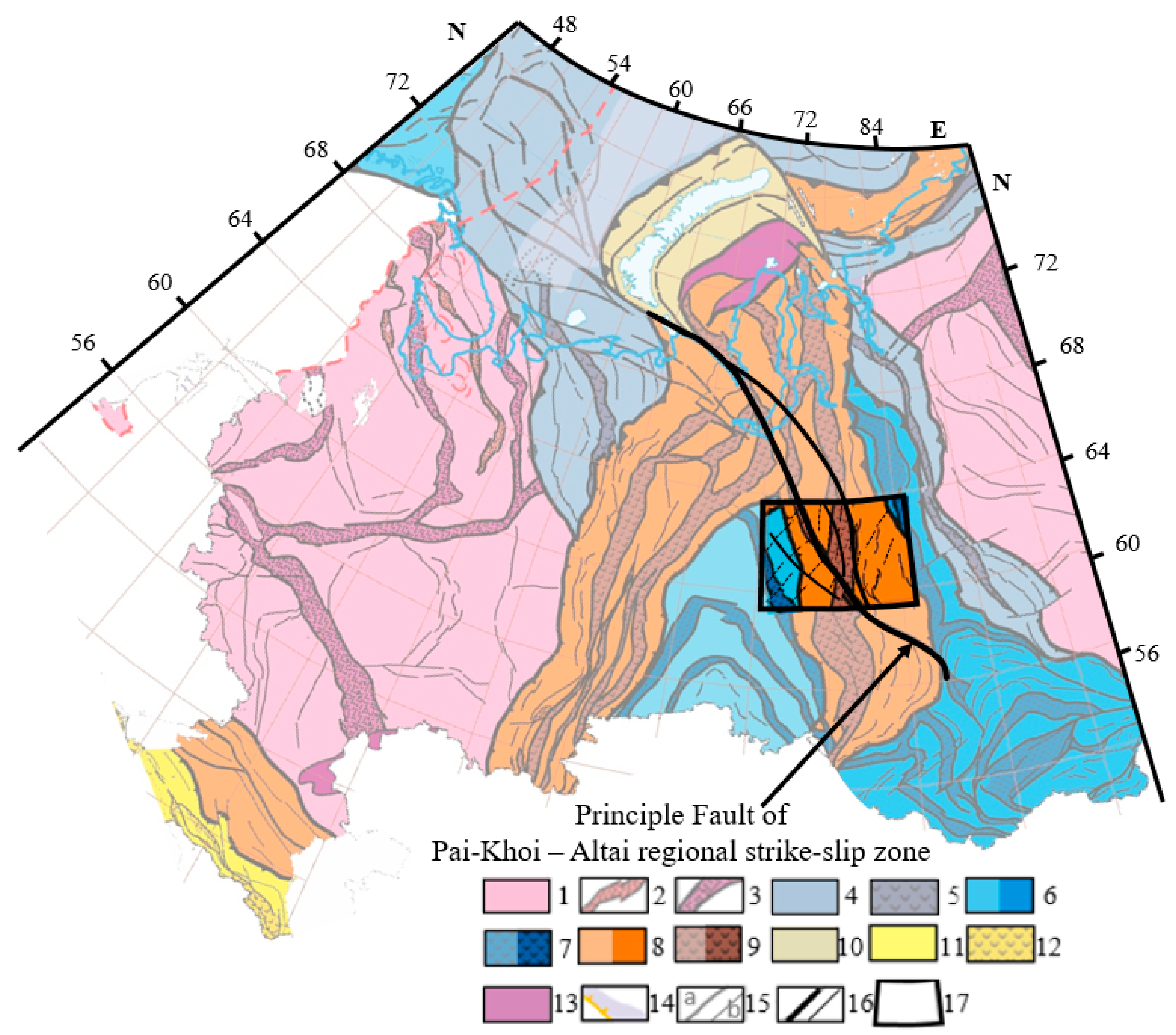
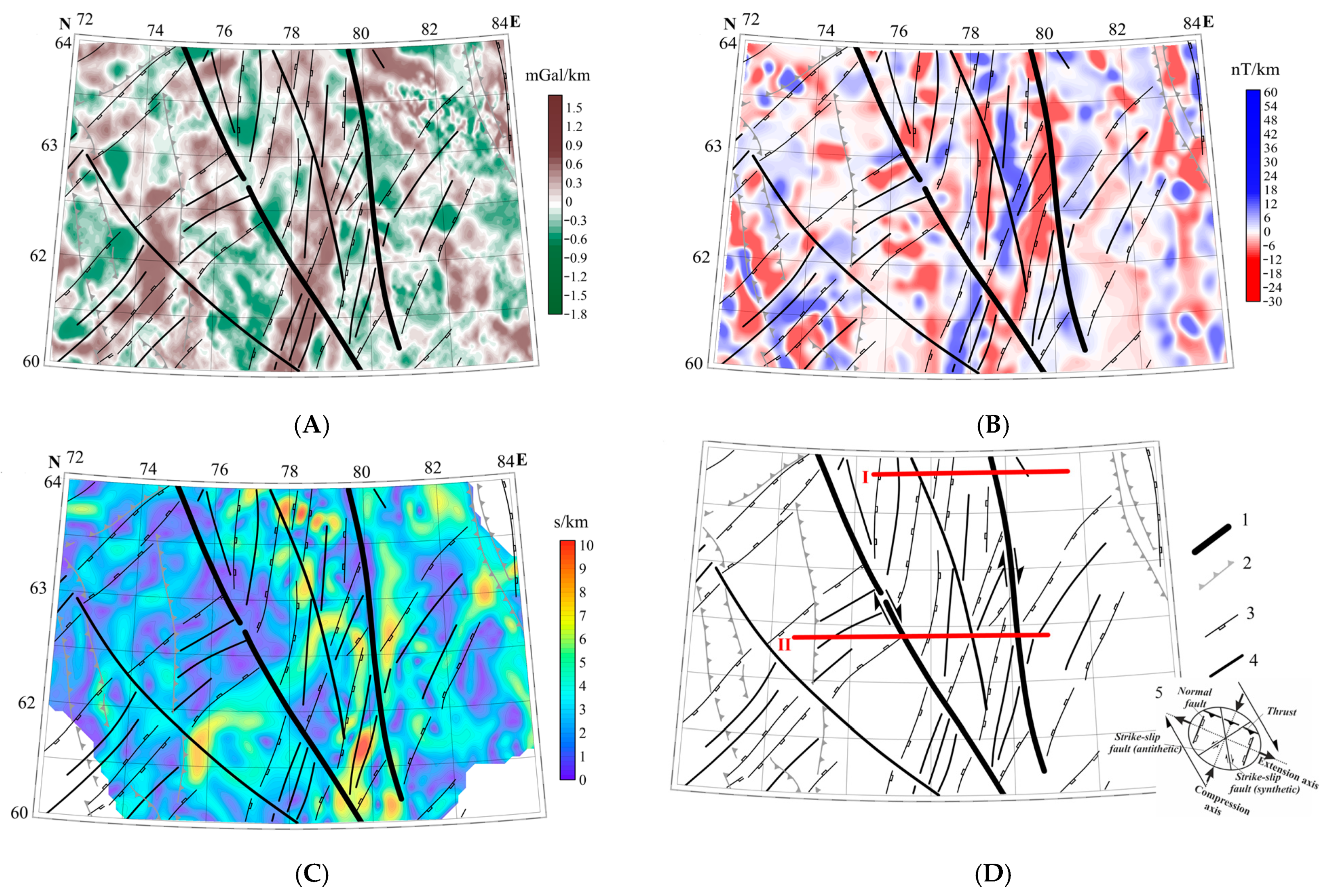
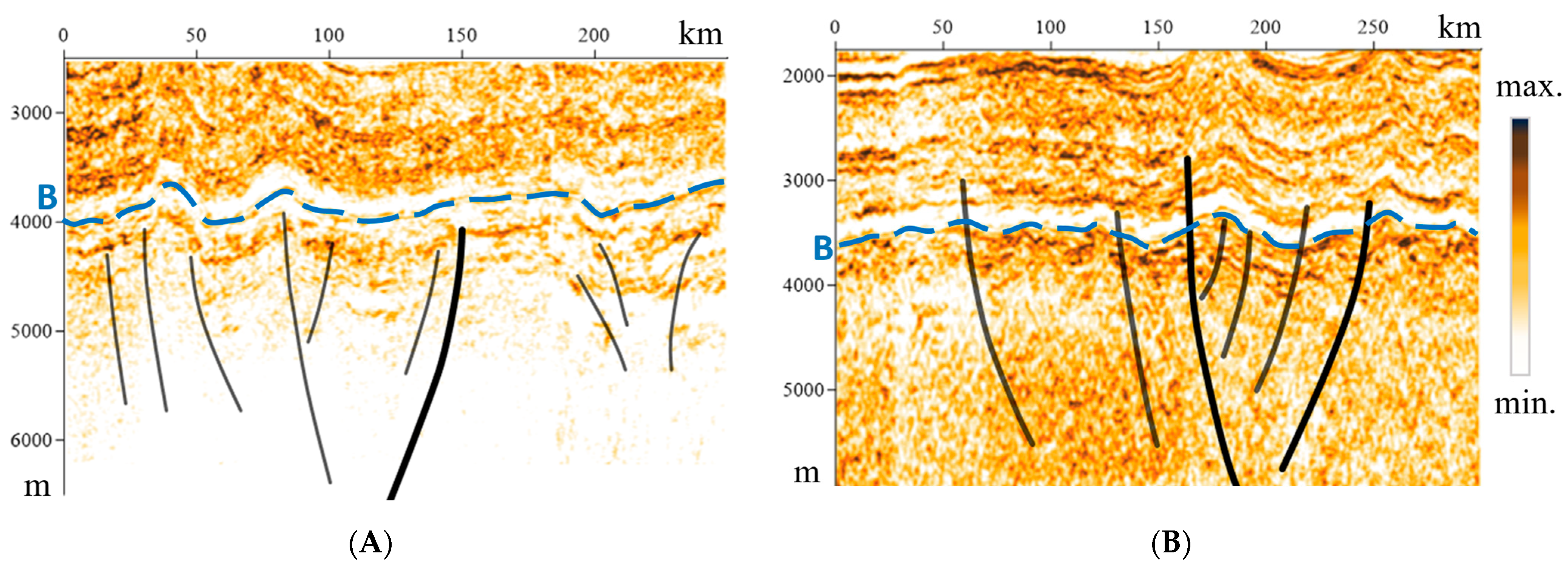
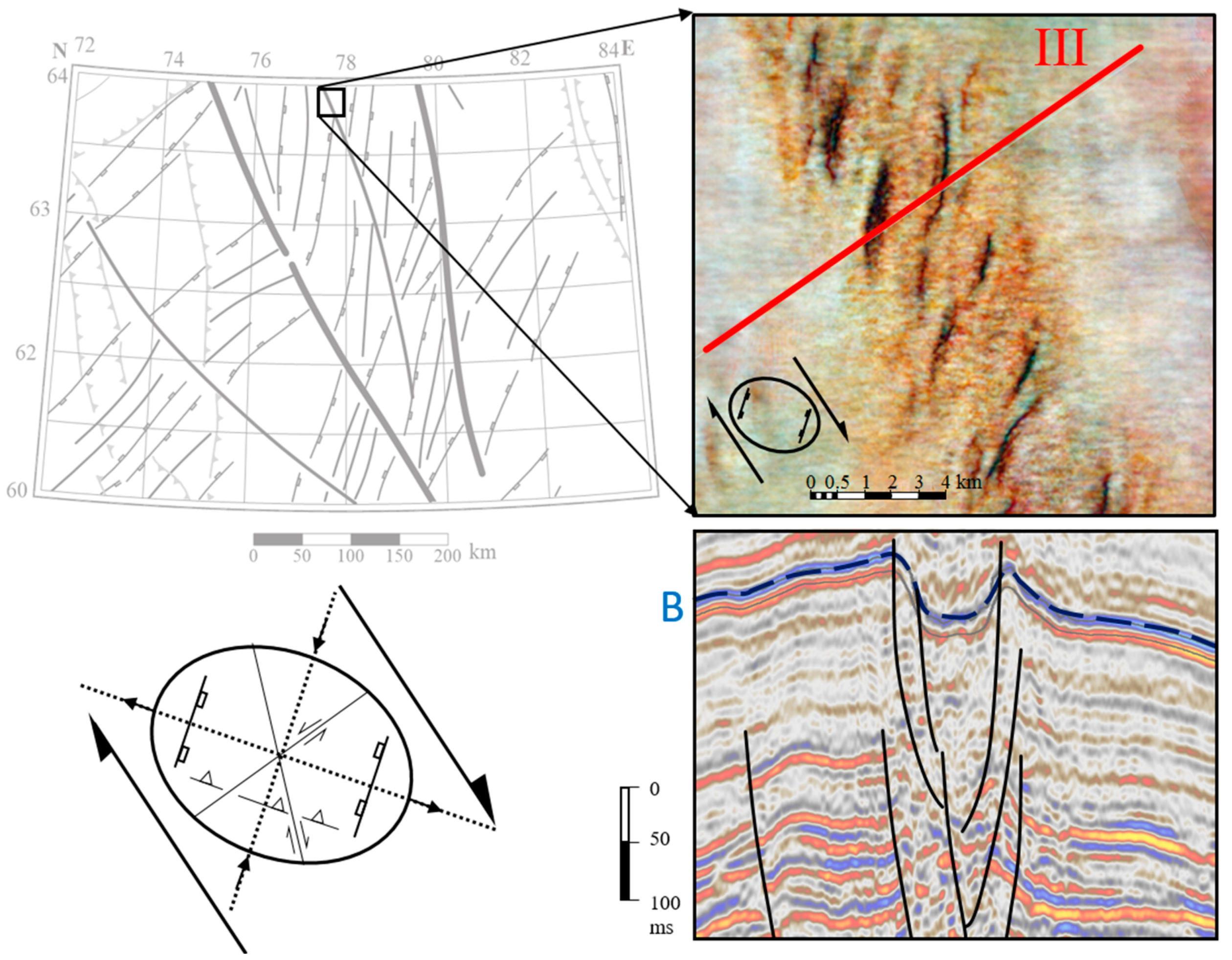
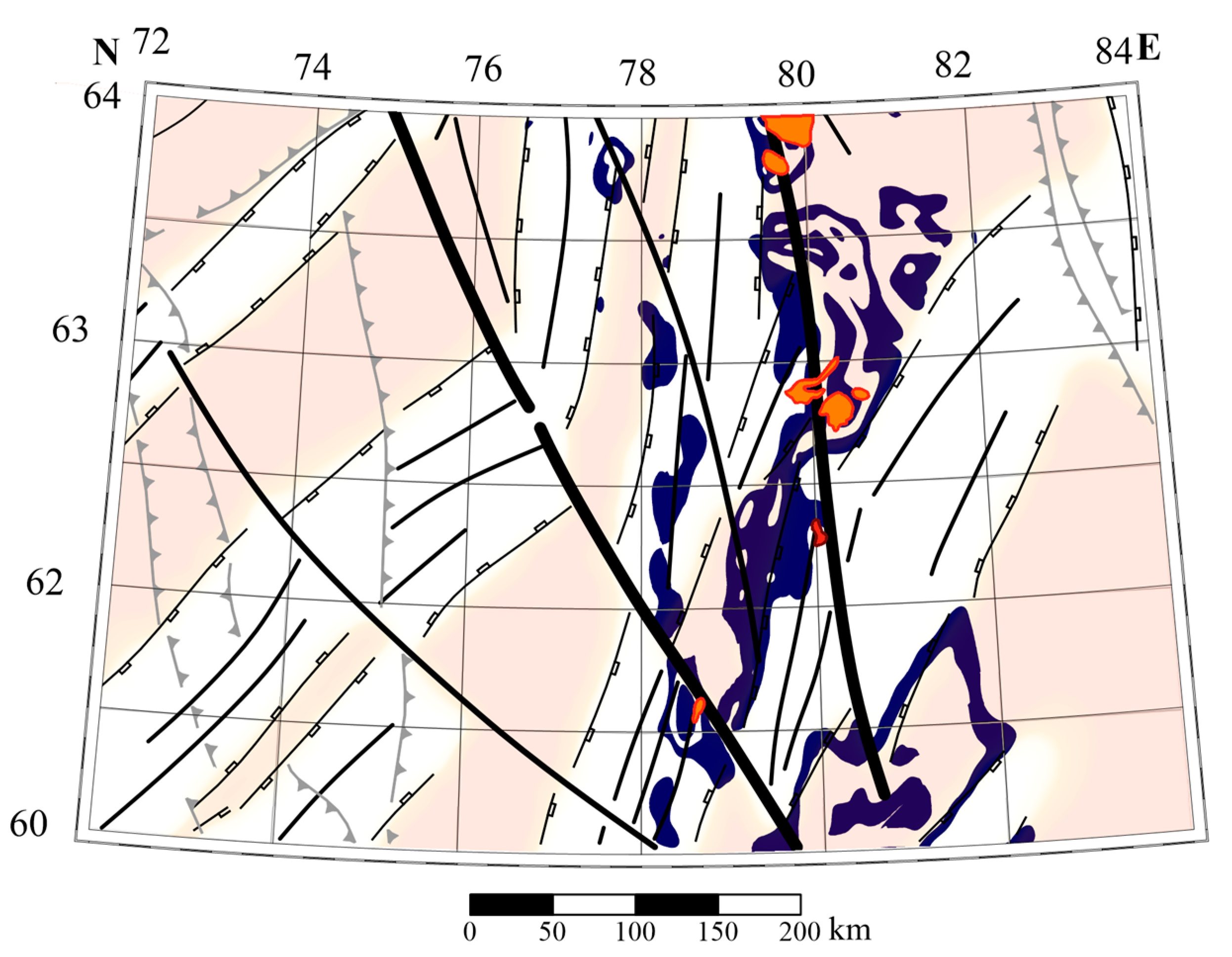
3. Characteristics of the Regional Pai-Khoi-Altai Strike-Slip System

The importance of evaluating the effects of tectonic disruptions on the rocks in the lower part of the platform cover and the geosyncline basement is exceptionally high. There are fundamental prerequisites for oil and gas potential in the pre-Jurassic rocks in this area: the presence of oil-source rocks in favorable conditions for hydrocarbon “maturation” and the existence of a cap rock. An important element is the presence and positioning of reservoirs, which could be located in areas where hydrothermal alteration processes occur due to tectonic activity [21,33]. According to various authors, deep-seated tectonic processes led to leaching of feldspar from acidic rocks, karst formation in carbonate rocks, the development of caverns and fractures, and the leaching of minerals from basic lavas (basalts), resulting in the formation of porous and fractured reservoirs [21,34,35]. Traps in such rocks are typically located in structural highs of the basement (with more developed weathering crust), in areas of Triassic rock exposure on basement uplifts [7], and near fault disruptions that create collectors and tectonic-screened traps [36].
To gain a better understanding of the patterns of deposit localization in areas influenced by the principal strike-slip fault and surrounding feathering dislocations, a tectonic reconstruction and detailed analysis of the placement of disjunctive dislocations are required. To describe typical deformations associated with strike-slip faults, the concept of “flower structures,” proposed by Harding T.P. in the early 1970s in the process of seismic data analysis [37], is used. Strike-slip dislocations are characterized by an almost vertical narrow zone of deformation at deep levels of the section and an expansion of the dislocation area approaching the surface (see Figure 4). Various-scale strike-slip zones exhibit complex morphology, intense disruption of host rocks, and a wide stratigraphic range of oil and gas potential due to the high fluid permeability of “through” subvertical faults.
The formation of “flower structures” may disrupt the integrity of the reservoir with the creation of tectonically screened traps. Deposits in zones with the development of such structures will have a complex blocky or lens-like character, likely without a single water-oil contact. Furthermore, the actual development of tectonic faults results in the formation of additional porous space in reservoirs of various types [31,38], including in the weathering crust of the basement and weakly metamorphosed sediments in areas adjacent to fault disruptions and fluid alteration zones.
The presence of regional strike-slip faults in Western Siberia was noted by Ivanov K.S. et al. in 2005 [39], based on deep drilling data and potential field interpretation results. In 2007, K.O. Sobornov [40] came to the same conclusion based on regional seismic survey data. Independently, the presence of a strike-slip fault zone was suggested by Egorov A.S. and Antonchik V.I. based on comprehensive studies of the deep structure of the Earth’s crust [23,41,42]. Later, the strike-slip fault zone stretching from the Pai-Khoi-Novozemelsk fold area to the Altai-Sayan fold area was studied by various authors [16,40], and it was given various names, such as the “Trans-Eurasian fault” or “Trans-Eurasian left-lateral fault” [43], the “Main strike-slip zone of Western Siberia” [40], “left-lateral fault system” [18] and others. The kinematics of the principle fault of the strike-slip zone is the subject of numerous discussions. Both left- and right-lateral kinematics are assumed. In certain regions, the distribution of a system of Neogene-Quaternary horizontal strike-slips in Paleozoic basement was observed, resulting in complex plicative and disjunctive deformations of the sedimentary cover [15] and perhaps even the fault inversion.
The location of the principal strike-slip fault varies significantly among different authors. In our study, the refined position of the principal and adjacent strike-slip dislocations is presented within an area up to 200 km in width. The structure of tectonic deformations heterogeneities of the basement and sedimentary cover of the West Siberia geosyncline are well manifested in potential fields. Zones of Jurassic sedimentary filling of consolidated basement depressions are reflected in gravimetric and magnetic data, as sedimentary rocks have lower density and magnetization compared to most consolidated basement rocks. Accordingly, the accumulation of sedimentary deposits in troughs during the Mesozoic era should be manifested as negative anomalies in potential fields. Rift structures, on the other hand, where sediments are complemented by dense and magnetized volcanics, manifest as positive anomalies in potential fields (Figure 5).
The analysis of the localization patterns of the identified principal strike-slip faults and the feathering rift dislocations allows us to draw conclusions about the kinematics of the principal strike-slip fault zone under consideration. To solve this problem, the “strain ellipsoid” model was applied, according to which the total stress in the strike-slip zone is considered to be the result of the superposition of tension and compression stress fields developing along the shear zone [44]. To decipher the deformations mapped on the research area, the right-lateral strike-slip model is most confidently suitable. In this case, stretching deformations (rifts) develop along the short axis of the ellipsoid at an angle of about +45° to the shear axis (Figure 5D).
However, it is necessary to explain the differences in the orientation of the rift structures in the three zones of the research area: the steepest angles relative to principal strike-slip faults are noted in the southwestern and northeastern parts of the research area; the most gentle are in the central zone located between the two principal strike-slip faults. Such picture is explained in the same work by R.G Park [44], in which the author, with reference to earlier works, showed that under conditions of general compression of the strike-slip zone, rifts are oriented at a steeper angle (60° or more) to the strike-slip axis; under extension conditions, the slope of the rifts decreases to 25–30°. This zonality can be used as a predictive sign of the localization of hydrocarbon traps.
Strike-slip structures are revealed in sections of the West Siberia sedimentary basin at different scales. For example, in 3D seismic survey data, strike-slips extending tens of kilometers form systems of disruptions within the Mesozoic layers [15]. When interpreting data from regional 2D seismic survey profiles at deeper levels of the section, the “flower structure” is less clearly observed due to the chaotic distribution of the wave field [45]. Figure 6 schematically illustrates the manifestation of the principal and adjacent feathering dislocations of the strike-slip zone.
Results of the analysis of geological–geophysical data and previous studies allow us to characterize the strike-slip fault as a long-lived structure, formed during the pre-rift stage of the region’s evolution and continuing its tectonic activity during the post-rift stage of sediment accumulation in the West Siberia basin [40]. From our point of view, the beginning of the strike-slip formation should be correlated with the final stage of Hercynian orogeny, and active tectonic movements probably continued until the end of the Jurassic. Our research indicates that dislocations associated with the Pai-Khoi-Altai regional strike-slip are primarily manifested at the Mesozoic level of the sedimentary cover and in the consolidated basement. The presence of strike-slip dislocations is almost absent in the layers located above the Bazhenov horizon. Therefore, at the end of the Mesozoic and Cenozoic eras, the considered structure probably did not exhibit activity. Nevertheless, traces of the strike-slip fault zone’s influence may be found in the folded structures of overlying horizons.
One of the clear confirmations of the position and structure of the regional strike-slip structure is in 3D seismic data, presented fragmentarily within small areas at the polygon. Data at one of the oil fields, studied by 3D seismic exploration at the level of the reflecting horizon B, indicate that the dominant strike-slip zone of the north–northwest direction. As practice shows [46,47], one of the best ways to demonstrate 3D seismic data is spectral decomposition, so this approach was used for the visualization of the Bazhenov formation surface in Petrel software. Taking into account orientation of en-echelon folds and faults, we can assume right-lateral kinematics. The section along line III confirms the presence and intensity of the flower structure (Figure 7).

4. Predictive Assessment of the Study Area Based on Geological, Structural, and Geophysical Data

The study area is characterized by a high density location of oil and gas deposits and, consequently, the area is highly studied by geological and geophysical methods [48]. Third-generation of state geological maps (sheets P-43, P-44) are available online [49]. Three profiles of deep seismic sounding («Bitum», «Kimberlite», and «Quartz») are laid here, as well as a series of regional 2D seismic (CDP) profiles. Within individual deposits and prospective zones, numerous 3D seismic survey areas are localized. Digital gravity and magnetic survey data are available on a scale of 1:1,000,000 [50,51].
Rift structures served as zones of organic matter accumulation and provided heating of these layers to achieve a high degree of catagenesis for oil maturity [52], ensuring their migration capability. Several deposits are localized on the periphery of rifts [53], which makes it reasonable to use gravity and magnetic data as indirect predictive factors. Intrusions of various compositions are distinctly manifested in potential fields as isometric anomalies of different signs and amplitudes.
To study the heterogeneities of the sedimentary cover and conduct predictive assessments for oil and gas, several techniques are applied, such as the method of gravimetric detection of oil and gas (GDOG) [54], the method for identifying “deposit-type” anomalies (DTA) [55] and others. However, direct hydrocarbon reservoir prediction methods based on potential fields generally do not demonstrate high effectiveness.
The comprehensive interpretation method applied in this work, developed by A.S. Dolgal [56], consists of the following procedures: filtering (transformation), zoning (classification), combining the results of methodical interpretation, identification of prospective zones (forecast), and modeling.
Formalized forecasting within the study area is performed using a pattern recognition algorithm that utilizes geological-structural and geophysical parameters available in digital format as factors for training.
The optimal set of geophysical transformations for predictive assessment in the study area includes calculating the horizontal gradient magnitude to enhance the contrast of block boundaries and fault dislocations; calculating the vertical derivative of the field for contrasting the manifestations of local anomaly-forming objects (Oasis Montaj software), which can assist in mapping blocks and sutural zones, fault dislocations, basement protrusions, and granitic massifs; mapping “blocks” identified on gravity and magnetic fields [55], considering uniform amplitude–frequency characteristics of the fields; and analyzing the relief morphology of the basement [57]. Horizontal gradient is the simplest transformation for identifying interblock zones based on geophysical data. In the future, it may be interesting to use improved versions of the horizontal gradient (Enhanced Horizontal Gradient Amplitude (EHGA) [58,59] or Enhanced Total Gradient (ETG) [60]. Their use will help more accurately determine the position of faults—elements of the strike-slip zone.
In addition to tectonic parameters, we introduced the “horizontal gradient module of the isochron reflecting the “B” horizon” as a predictive factor (which can also be improved using various techniques [59]). This corresponds to the angle of inclination of the Bazhenov suite’s surface. There is a visual correlation between the hydrocarbon reservoirs of the Jurassic basement and the areas with significant tilting of this surface [61,62]. This can be explained by the impact of the strike-slip fault on the geometry of the Bazhenov suite’s roof, leading to the formation of specific traps.
As “training objects”, we selected deposits with reservoirs located at various depths, including those in rocks of Jurassic age (deposits 3–9 in Figure 3). The largest of the selected “training objects” is the Kharampur deposit (see Figure 3, deposit 4). The basement here is exposed to a depth of about 4 km, where it is represented by basalts; sediments of the Lower Jurassic age lie unconformably above. Within the deposit, 28 reservoirs of the sheet, massive, and lithological barrier types have been identified, primarily in sandstones. Due to tectonic disruptions, productive layers are fragmented into separate reservoirs with sharp heterogeneity, variability, and fracturing of the reservoirs [63]. On the Upper Kolik-Egan oil and gas condensate deposit (Figure 3, deposit 8), the Paleozoic basement is penetrated by wells to a depth of 3.2 km. It consists of shales, limestones (Lower Carboniferous age), and sedimentary terrigenous formations. In the productive part of the sedimentary sequence, the deposit has 62 layers [35]. The oil reservoir, located on an erosional–tectonic protrusion of the Paleozoic basement, is exposed on the Festival Square (Figure 3, deposit 5). The host rocks are represented by sedimentary and volcanic formations [64]. The heterogeneity of the reference sample, due to the different geological-structural positions of the reference hydrocarbon deposits, necessitates the use of a combination of forecasting methods and a large number of criteria.
The spacing of linear, contoured, and digital predictive features, formed on the basis of a complex of geological and geophysical data, is presented in Table 1. Within the pattern recognition technology, we carried out the following: the formation and mutual alignment of data matrix nodes; the selection of the optimal interpolation procedure with averaging of the final areal distributions; a detailed analysis of the morphology of primary features; the formalization of initially non-digital features; and, specifically, object recognition with training. To implement the latter, a discriminant analysis in an author’s modification was applied, aimed at considering a small neighborhood of an individual point in the reference sample as an independent reference object in a multidimensional feature space. The result of the analysis is predictive aureoles distributed over the study area and verified using the K-means method [65] realized in proprietary software.
Joint processing, implemented in the multidimensional space of the mentioned geological–structural and geophysical features, aims to create predictive aureoles of potential object detection, similar to hydrocarbon reference objects. The result of using the modified discriminant analysis in conjunction with the K-means method is generalized by us in the form of a scalar field of the probability distribution of object detection, similar to hydrocarbon reference objects (Figure 8). It can be seen that in the probability value range exceeding 0.5 (highlighted with dark blue shading), the areas extend beyond the boundaries of reference objects, forming the most representative anomalies in the areas of junction of horst–graben boundaries and principal fault zones.
As evident, the location of reference deposits aligns with the nodes of intersection of the major fault with adjacent extensional structures. When analyzing the interpretation results, we pay attention to the specificity of the distribution of contours of hydrocarbon reference objects, forming groups with a regular spatial step, manifested both along the mentioned fault zone and in its vicinity. Quasi-periodic systems are a manifestation of wave structuring of the geological environment and find application in forecasting deposits of both ore [66,67], and oil and gas. Furthermore, the belt of increased probability of detecting deposits similar to reference ones marks known deposits with local areas of increased morphological variability. Predictive aureoles are elongated in several different directions and have a different distribution pattern in the blocks separated by principal dislocations, confirming the significance of the strike-slip fault as a controlling factor for the hydrocarbon potential of the region’s structures. Among the extensional structures, horsts tend to gravitate toward reference objects to the greatest extent.

5. Conclusions

The Pai-Khoi-Altai strike-slip zone covers a vast area and manifests itself as a system of two principal strike-slip dislocations and numerous adjacent horsts and grabens. Fundamental importance has the nature of feathering dislocations; our detailed reconstructions indicate right-lateral kinematics of the principal strike-slip faults (Figure 6 and Figure 7). In addition, this zone extends to the Altai-Sayan folded area, the dislocations of which, including the Kuznetsk Alatau, have right-lateral kinematics. According to seismic survey data, strike-slip dislocations are manifested at depths below the Bazhenov horizon; above it, predominantly fold structures are observed, which can also form traps for hydrocarbons, increasing the significance of the studied structure.
The obtained predictive estimates indicate the high prospects of areas adjacent to the eastern major strike-slip fault zone and adjacent horst structures. This is explained by the probable presence of tectonically weakened fluid-permeable zones; hydrocarbon traps in plicatic dislocations; sources of hydrocarbons in the lower horizons of the sedimentary cover; and favorable conditions for the maturation of organic matter and hydrocarbon generation.
In this work, a methodological approach has been tested, allowing the application of formalized tectonic and geodynamic criteria in automated forecasting of prospective deep-seated hydrocarbon deposits in the study area, including the application of neural network technologies [64,67]. Seismic section data have been applied to verify the identified tectonic elements and to confirm the configuration of the regional Pai-Khoi-Altai strike-slip zone. This direction using specially designed seismic attributes seems useful for this purpose [68,69]. In the future, it is planned to use the steerable pyramid attribute [67] for identifying the weak strike-slip faults and to test the innovate approach presented in papers [70,71] with a detailed assessment of pressure and direction of fluid migration.
Based on the results of geological interpretation of geophysical data, a geological-structural basis has been developed, the formalized elements of which have been applied as factors in object recognition with training on reference deposits. Surfer, Oasis Montaj, Petrel and proprietary programs were used to implement the work. Predictive modeling based on the analysis of deep structure and tectonic dislocations of various kinematics is a justified tool in regions with promising lower structural strata for oil and gas. From the analysis conducted, it is evident that reference deposits are located in those areas of the regional strike-slip zone adjacent to which extensional horst structures are present. Studying the geological processes of accumulation, both in the traditional organic paradigm and from the perspective of an inorganic “mantle” source of oil and gas, along with an analysis of the geophysical manifestations of hydrocarbon criteria, may be the key to discovering new deep-seated hydrocarbon deposits in Western Siberia.

Author Contributions

A.E. proposed the concept of work, methodology, review and editing; V.A. conducted the literature review, software and resources support; N.S. prepared original draft, calculated the transformations of the fields; I.M. fulfilled the forecast, and formal analysis; M.O. corrected the text of the article. All authors have read and agreed to the published version of the manuscript.

Funding

This research received no external funding.

Data Availability Statement

The data used in this work are available on request to the corresponding author due to privacy restrictions.

Acknowledgments

The authors thank the employees of the Geophysics Department of the Mining University for participation in discussions of the work.

Conflicts of Interest

The authors declare no conflict of interest.

References

  1. Efficient Use of the Resource and Production Potential of Western Siberia in the Implementation of Russia’s Energy Strategy until 2020. Available online: https://neftegaz.ru/science/development/332532-effektivnoe-use-resursno-proizvodstvennogo-potentsiala-zapadnoy-sibiri-v-realizatsii-energe/ (accessed on 19 September 2023).
  2. Litvinenko, V. The role of hydrocarbons in the global energy agenda: The focus on liquefied natural gas. Resources 2020, 9, 59. [Google Scholar] [CrossRef]
  3. Litvinenko, V.S.; Petrov, E.I.; Vasilevskaya, D.V.; Yakovenko, A.V.; Naumov, I.A.; Ratnikov, M.A. Assessment of the role of the state in the management of mineral resources. J. Min. Inst. 2023, 259, 95–111. [Google Scholar] [CrossRef]
  4. Timurziev, A.I. Oil in the basal complex of the Western Siberia: Reality and alternatives. Gorn. Vedom. 2016, 5–6, 100–118. [Google Scholar]
  5. Oil production in Western Siberia: Reloaded. Available online: https://vygon.consulting/products/issue-1400/ (accessed on 19 September 2023).
  6. Rogachev, M.K.; Mukhametshin, V.V.; Kuleshova, L.S. Improving the efficiency of using resource base of liquid hydrocarbons in Jurassic deposits of Western Siberia. J. Min. Inst. 2019, 240, 711. [Google Scholar] [CrossRef]
  7. Timurziev, A.I. Fundamental oil of Western Siberia: Reality and alternatives. Min. Her. 2016, 5–6, 100–118. (In Russian) [Google Scholar]
  8. Surkov, B.C.; Trofimuk, A.A.; Zhero, O.G. Triassic rift system of the West Siberia plate, its influence on the structure and oil and gas content of the platform Mesozoic-Cenozoic cover. Geol. Geophys. 1982, 8, 3–15. (In Russian) [Google Scholar]
  9. Kontorovich, A.E.; Zolotova, O.V.; Ryzhkova, S.V. Methodology for rational planning of geological exploration works in subsoil areas intended for licensing in the southern regions of Western Siberia. Geo-Sib 2007, 5, 148–151. [Google Scholar]
  10. Lobova, G.A.; Isaev, V.I.; Kuzmenkov, S.G.; Luneva, T.E.; Osipova, E.N. Oil and Gas Potential of Weathering and Paleozoic Reservoirs in the South-East of Western Siberia (Forecasting Hard-to-Recover Reserves). Geophys. J. 2018, 40, 73–106. (In Russian) [Google Scholar]
  11. Timurziev, A.I. Recent strike-slip tectonics of sedimentary basins: Tectonophysical and fluid-dynamic aspects (in connection with oil and gas potential) part 1. Deep Oil 2013, 1, 561–605. (In Russian) [Google Scholar]
  12. Khafizov, S.; Syngaevsky, P.; Dolson, J.C. The West Siberia Super Basin: The largest and most prolific hydrocarbon basin in the world. AAPG Bull. 2022, 106, 517–572. [Google Scholar] [CrossRef]
  13. Zhdaneev, O.V. Technological sovereignty of the Russian Federation fuel and energy complex. J. Min. Inst. 2022, 258, 1061–1070. [Google Scholar] [CrossRef]
  14. Kotikov, D.A.; Shabarov, A.N.; Tsirel, S.V. Connecting seismic event distribution and tectonic structure of rock mass. Gorn. Zhurnal 2020, 28–32. [Google Scholar] [CrossRef]
  15. Gogonenkov, G.N.; Timurziev, A.I. Shear deformations in the cover of the West Siberia Plate and their role in the exploration and development of oil and gas fields. Geol. Geophys. 2010, 51, 384–400. (In Russian) [Google Scholar]
  16. Nassonova, N.V.; Romancheev, M.A. Geodynamic control of oil and gas content by shear dislocations in the east of Western Siberia. Geol. Oil Gas 2011, 4, 8–14. (In Russian) [Google Scholar]
  17. Smirnov, O.A.; Lukashov, A.V.; Nedosedkin, A.S.; Moiseev, S.A. Stratigraphic pinch-out zones in riphean deposits as promising exploration targets for expanding gazprom’s mineral resources base in the central and western parts of the Siberia platform. GeoBaikal 2018, 2018, 1–5. [Google Scholar] [CrossRef]
  18. Igoshkin, V.J.; Dolson, J.C.; Sidorov, D.; Bakuev, O.; Herbert, R. New Interpretations of the Evolution of the West Siberia Basin, Russia: Implications for Exploration; American Association of Petroleum Geologists: Tulsa, OK, USA, 2008; pp. 1–35. [Google Scholar]
  19. Surkov, V.S.; Zhero, O.G. Foundation and Development of Platforms Change Cover of the West Siberia Plate; Nedra: Moskow, Russia, 1984; 143p. (In Russian) [Google Scholar]
  20. Naseer, M.T. Spectral decomposition-based quantitative inverted velocity dynamical simulations of early cretaceous shaly-sandstone natural gas system, Indus Basin, Pakistan: Implications for low-velocity anomalous zones for gas exploration. Nat. Resour. Res. 2023, 32, 1135–1146. [Google Scholar] [CrossRef]
  21. Naseer, M.T. Seismic attributes and quantitative stratigraphic simulation’ application for imaging the thin-bedded incised valley stratigraphic traps of Cretaceous sedimentary fairway, Pakistan. Mar. Pet. Geol. 2021, 134, 105336. [Google Scholar] [CrossRef]
  22. Razmanova, S.V.; Andrukhova, O.V. Oilfield service companies as part of the economy digitalization: Assessment of the prospects for innovative development. J. Min. Inst. 2020, 244, 482–492. [Google Scholar] [CrossRef]
  23. Egorov, A.S. Deep Structure and Geodynamics of the Lithosphere of Northern Eurasia according to the Results of Geol.-Geofiz; Modeling along the Geotraverses of Russia: St. Petersburg, Russia, 2004; pp. 13–28. (In Russian) [Google Scholar]
  24. Astapov, A.P.; Braduchan, Y.V.; Borovsky, V.V.; Voronin, A.S.; Gorelina, T.E.; Kovrigina, E.K.; Lebedeva, E.A.; Markina, T.V.; Matyushkov, A.D.; Rubin, L.I.; et al. State Geological Map of the Russian Federation. Scale 1: 1,000,000 (Third Generation). Series West Siberia. Sheet P43—Surgut. Explanatory Note; VSEGEI Map Factory: St. Petersburg, Russia, 2012; 342p. [Google Scholar]
  25. Faibusovich, Y.E.; Voronin, A.S.; Markina, T.V.; Rubin, L.I.; Chekanov, V.I. State Geological Map of the Russian Federation, Scale 1: 1,000,000 (Third Generation). Series West Siberia. Sheet P-44—P. Wah. Explanatory note; VSEGEI Publishing House: St. Petersburg, Russia, 2020; 192p. [Google Scholar]
  26. Gusev, E.A. Results and prospects of geological mapping of the Arctic shelf of Russia. J. Min. Inst. 2022, 255, 290–298. [Google Scholar] [CrossRef]
  27. Punanova, S.A.; Shuster, V.L. A new look at the prospects for oil and gas potential of deep-seated pre-Jurassic deposits in Western Siberia. Georesources 2018, 20, 67–80. [Google Scholar] [CrossRef]
  28. Ulmishek, G.F. Petroleum Geology and Resources of the West Siberia basin, Russia. U.S. Geological Survey Bulletin 2201-G. 2003. Available online: https://pubs.usgs.gov/bul/2201/G/ (accessed on 19 September 2023).
  29. Stupakova, A.V.; Sokolov, A.V.; Soboleva, E.V.; Kurasov, I.A.; Bordyug, E.V.; Kiryukhina, T.A. Geological study and oil and gas potential of the Paleozoic deposits of Western Siberia. Georesources 2015, 2, 63–76. (In Russian) [Google Scholar] [CrossRef]
  30. Vazhenina, O.A.; Trigub, A.V. Forecast of pre-Jurassic basement rock filling with hydrocarbons based on oil and gas systems modeling (Western Siberia). Geol. Oil Gas 2018, 4, 39–51. (In Russian) [Google Scholar]
  31. Big Oil of Siberia. Available online: https://www.igm.nsc.ru/images/history/book/21_igig_total_245-260.pdf (accessed on 19 September 2023).
  32. Ageev, A.S.; Ilalova, R.K.; Duryagina, A.M.; Talovina, I.V. A link between spatial distribution of the active tectonic dislocation and groundwater water resources in the Baikal-Stanovaya shear zone. Min. Inf. Anal. Bull. 2019, 5, 173–180. [Google Scholar] [CrossRef]
  33. Sohrabi, A.; Nadimi, A.; Talovina, I.V.; Safae, I.H. Structural model and tectonic evolution of the fault system in the southern part of the Khur area, Central Iran. Notes Min. Inst. 2019, 236, 142–152. [Google Scholar] [CrossRef]
  34. Khisamutdinova, A.I.; Alekseeva, P.A.; Romanchuk, A.F.; Miroshnichenko, D.E.; Kerusov, I.N.; Bakulin, A.A.; Kucheryavenko, D.S.; Kiryanova, T.N. The structure and forecast of reservoirs of the pre-Jurassic complex in one of the sections of the Elizarovsky trough of the Frolov megadepression according to 3d seismic data in the absence of well information. Oil Gas Geology. Theory Pract. 2021, 16, 1–17. [Google Scholar] [CrossRef]
  35. Talovina, I.V.; Krikun, N.S.; Yurchenko, Y.Y.; Ageev, A.S. Remote sensing techniques in the study of structural and geotectonic features of Iturup island (the Kuril islands). Notes Min. Inst. 2022, 254, 158–172. [Google Scholar] [CrossRef]
  36. Shuster, V.L.; Punanova, S.A. Prospects for the oil and gas potential of deep Jurassic and pre-Jurassic deposits in the north of Western Siberia in unconventional traps. Georesources 2021, 23, 30–41. [Google Scholar] [CrossRef]
  37. Huang, L.; Liu, C. Three Types of Flower Structures in a Divergent-Wrench Fault Zone: The Third Type of Flower Structures. J. Geophys. Res. Solid Earth 2017, 122. [Google Scholar] [CrossRef]
  38. Lavrova, N.V. To the question of the evolution of deformation zones in platform conditions on the example of the Kungur Ice Cave (Urals). Notes Min. Inst. 2020, 243, 279–284. [Google Scholar] [CrossRef]
  39. Ivanov, K.S.; Fedorov, Y.N.; Kormiltsev, V.V. Shear system in the basement of the West Siberia megabasin. Dokl. Akad. Nauk. 2005, 405, 371–375. (In Russian) [Google Scholar]
  40. Smirnov, O.A.; Borodkin, V.N.; Lukashov, A.V.; Plavnik, A.G.; Trusov, A.I. Regional model of riftogenesis and structural-tectonic zoning of the north of Western Siberia and the South Kara syneclise according to the complex of geological and geophysical studies. Neftegazov. Geol. Theory Pract. 2022, 17, 1. Available online: http://www.ngtp.ru/rub/2022/1_2022.html (accessed on 19 September 2023).
  41. Egorov, A.S.; Ageev, A.S. Tectonic zoning and sequence of formation of consolidated crust of Northern Eurasia and adjacent shelf. In Proceedings of the Materials of the LIV Tectonic Meeting Tectonics and Geodynamics of the Earth’s Crust and Mantle: Fundamental Problems, Moscow, Russia, 31 January–4 February 2023; pp. 155–160. [Google Scholar]
  42. Egorov, A.S.; Smirnov, O.E.; Vinokurov, I.Y.; Kalenich, A.P. Similarities and differences in the structure of the Ural and Paikhoi-Novaya Zemlya folded regions. Notes Min. Inst. 2013, 200, 34–42. [Google Scholar]
  43. Sobornov, K.O. Late Paleozoic-Cenozoic structural development and oil content of Western Siberia. In Proceedings of the International Conference of Geophysicists and Geologists, Tyumen, Russia, 4–7 December 2007; pp. 11–14. (In Russian). [Google Scholar]
  44. Park, R.G. Geological Structures and Moving Plates; Blackie: Glasgow, UK; London, UK, 1988; 337p. [Google Scholar]
  45. Mingaleva, T.; Gorelik, G.; Egorov, A.; Gulin, V. Correction of depth-velocity models by gravity prospecting for hard-to-reach areas of the shelf zone. MIAB Min. Inf. Anal. Bull. 2022, 77–86. [Google Scholar] [CrossRef]
  46. Naseer, M.T. Appraisal of tectonically-influenced lowstand prograding clinoform sedimentary fairways of Early Cretaceous Sember deltaic sequences, Pakistan using dynamical reservoir simulations: Implications for natural gas exploration. Mar. Pet. Geol. 2023, 151, 106166. [Google Scholar] [CrossRef]
  47. Naseer, M.T.; Naseem, S.; Shah, M.A. Simulating the stratigraphy of meandering channels and point bars of Cretaceous system using spectral decomposition tool, Southwest Pakistan: Implications for petroleum exploration. J. Pet. Sci. Eng. 2022, 212, 110201. [Google Scholar] [CrossRef]
  48. Zhdaneev, O.V.; Zaitsev, A.V.; Lobankov, V.M. Metrological support of equipment for geophysical research. Notes Min. Inst. 2020, 246, 667–677. [Google Scholar] [CrossRef]
  49. Digital Catalog of the State Geological Maps of the Russian Federation scale 1:1,000,000 (Third Generation). Available online: https://www.vsegei.ru/ru/info/pub_ggk1000-3/ (accessed on 19 September 2023).
  50. The World Magnetic Model. Available online: https://www.ngdc.noaa.gov/geomag/WMM/ (accessed on 19 September 2023).
  51. WGM2012 Global Model. Available online: https://bgi.obs-mip.fr/data-products/grids-and-models/wgm2012-global-model/ (accessed on 19 September 2023).
  52. Marin, Y.B. On mineralogical studies and the use of mineralogical information in solving petro- and ore genesis problems. Geol. Ore Depos. 2021, 63, 625–633. [Google Scholar] [CrossRef]
  53. Khaliulin, I.I.; Shelikhov, A.P.; Yaitsky, N.N. Analysis of the relationship between anomalies of potential fields and the structural framework of the sedimentary cover of Western Siberia. In Questions of Theory and Practice of Geological Interpretation of Geophysical Fields: Materials of the 47th Session of the International Scientific Seminar of D. G. Uspensk -V. N. Strakhova; VSU: Voronezh, Russia, 2020; pp. 288–290. (In Russian) [Google Scholar]
  54. Mikhailov, I.N.; Veselov, K.E. Results and place of gravity exploration in the problem of direct forecasting of oil and gas. Appl. Geophys. 1989, 120, 147–153. (In Russian) [Google Scholar]
  55. Kulikov, G.N.; Mavrichev, V.G. Aeromagnetic exploration for oil and gas. Geophysics 1995, 2, 37–42. (In Russian) [Google Scholar]
  56. Dolgal, A.S. Computer Technologies for the Interpretation of Gravitational and Magnetic Fields in Mountainous Terrain. Ph.D. Thesis, Russian Academy of Sciences, Moscow, Russia, 2002; 343p. (In Russian). [Google Scholar]
  57. Ananyev, V.V.; Grigoryev, G.S.; Gorelik, G.D. Physical modeling of the Bazhenov formation in combination with CSEM and seismic methods. E3S Web Conf. 2021, 266, 07003. [Google Scholar] [CrossRef]
  58. Stephen, E., II; Mohammed, E.A.; Ogiji-Idaga, A.; Anthony, A.; Luan, P.; Kamal, A.; David, G.-O.; Ubong, B.; Fnais, M. Application of the enhanced horizontal gradient amplitude (EHGA) filter in mapping of geological structures involving magnetic data in Southeast Nigeria. J. King Saud Univ. Sci. 2022, 34, 102288. [Google Scholar] [CrossRef]
  59. Luan, P.; Erdinc, O.; Özkan, K.; Phan, T.; Dat, N.; Quynh, V.; Sang, L.; Do, T. Determination of subsurface lineaments in the Hoang Sa islands using enhanced methods of gravity total horizontal gradient. Vietnam J. Earth Sci. 2022, 44, 1–15. [Google Scholar] [CrossRef]
  60. Prasad, K.; Luan, P.; Anand, S.; Ahmed, M.E.; Kamal, A.; Fnais, M.; David, G.-O. A Novel Enhanced Total Gradient (ETG) for Interpretation of Magnetic Data. Minerals 2022, 12, 1468. [Google Scholar] [CrossRef]
  61. Mingaleva, T.A.; Shakuro, S.V.; Egorov, A.S. Analysis of studies, observed results of geophysical surveys in areas contaminated with LNAPL. Russ. J. Earth Sci. 2023, 1, 1–16. [Google Scholar] [CrossRef]
  62. Oil and Gas Potential of Pre-Jurassic Rock Complexes in Western Siberia. Available online: https://geonedra.ru/2020/neftegazonosnost-doyurskogo-kompleksa/ (accessed on 19 September 2023).
  63. Reservoirs of Hydrocarbons in Erosional-Tectonic Protrusions of Pre-Jurassic Rocks in the Southeastern Part of the Western Siberia Plate. Available online: https://neftegaz.ru/science/development/332012-rezervuary-uglevodorodov-v-erozionno-tektonicheskikh-vystupakh-doyurskikh-porod-yugo-vostochnoy-chas/ (accessed on 19 September 2023).
  64. Movchan, I.V.; Yakovleva, A.A.; Frid, V.; Movchan, A.B.; Shaygallyamova, Z.I. Modeling of seismic assessment for large geological systems. Philos. Trans. R. Soc. A Math. Phys. Eng. Sci. 2022, 380. [Google Scholar] [CrossRef]
  65. Mokeev, V.V.; Tomilov, S.V. On the efficiency of image analysis and recognition using the principal component method and linear discriminant analysis. In Vestnik SUSU, vol. 13, no. 3. Series “Computer Technologies, Control, Radio Electronics”; South Ural State University: Chelyabinsk, Russia, 2013; pp. 61–70. [Google Scholar]
  66. Ageev, A.; Egorov, A.; Krikun, N. The principal characterized features of Earth’s crust within regional strike-slip zones. In Advances in Raw Material Industries for Sustainable Development Goals; CRC Press: London, UK, 2020; pp. 78–83. [Google Scholar]
  67. Kochnev, A.A.; Kozyrev, N.D.; Kochneva, O.E.; Galkin, S.V. Development of a comprehensive methodology for the forecast of effectiveness of geological and technical measures based on machine learning algorithms. Georesursy 2020, 22, 79–86. [Google Scholar] [CrossRef]
  68. Tang, Q.; Tang, S.; Luo, B.; Luo, X.; Feng, L.; Li, S.; Wu, G. Seismic Description of Deep Strike-Slip Fault Damage Zone by Steerable Pyramid Method in the Sichuan Basin, China. Energies 2022, 15, 8131. [Google Scholar] [CrossRef]
  69. Naseer, M.T. Seismic attributes and reservoir simulation’ application to image the shallow-marine reservoirs of Middle-Eocene carbonates, SW Pakistan. J. Pet. Sci. Eng. 2020, 195, 107711. [Google Scholar] [CrossRef]
  70. Ze, T.; He, Z.; Alves, T.M.; Guo, X.; Gao, J.; He, S.; Zhao, W. Structural inheritance and its control on overpressure preservation in mature sedimentary basins (Dongying depression, Bohai Bay Basin, China). Mar. Pet. Geol. 2022, 137, 105504. [Google Scholar] [CrossRef]
  71. Jing, S.; Alves, T.M.; Omosanya, K.O.; Hales, T.C.; Ze, T. Tectonic evolution of strike-slip zones on continental margins and their impact on the development of submarine landslides (Storegga Slide, northeast Atlantic). GSA Bull. 2020, 132, 2397–2414. [Google Scholar] [CrossRef]
Figure 1. Location map showing the Pai-Khoi-Altai regional strike-slip zone in the West Siberia basin. Symbols: 1–3—ancient platforms; 4–5—Baikalian folded areas and interblock suture zones; 6–7—Caledonian folded; 8–9—Hercynian folded area; 10—Cimmerian folded areas; 11–12—Alpine folded areas; 13—oceanic areas; 14—continental slopes and deep-sea depressions; 15—faults; 16—faults of the Pai-Khoi-Altai strike-slip zone; 17—research site.
Minerals 13 01511 g001
Figure 2. Stratigraphic position of major oil source beds and reservoirs.
Minerals 13 01511 g002
Figure 3. Oil and gas field near the study area. Grey color indicates oil and gas fields; red shades indicates fields with pre–Jurassic reservoirs. Fields are marked with numbers: 1—Severo-Varieganskoye (reservoir—fractured volcanic and basement, pink); 2—Sovetskoye (weathered mafic volcanics and fractured limestones, pink); 3—Kotygyeganskoe (dolomitic breccia of Paleozoic age, dark red). Pre-Jurassic fields with oil and gas pools (orange): 4—Kharampur; 5—Festivalnoye; 6—Bakhilovskoye; 7—Varyngskoye; 8—Verkhnekolik-Yeganskoye; 9—Severnoye field.
Minerals 13 01511 g003
Figure 4. A conceptual diagram of the “flower structure” and fields associated with strike-slip deformations.
Minerals 13 01511 g004
Figure 5. Maps of the vertical derivative of the gravitational field in Bouguer reduction (A), the vertical derivative of the anomalous magnetic field (B), the horizontal gradient of the isochron reflecting the “B” horizon (C), and the results of tectonic decoding (D). 1—major faults; 2—fold boundaries; 3—boundaries of horst-graben structures; 4—other fault disruptions; 5—strain ellipsoid. Red lines indicate the positions of seismic sections presented in Figure 6.
Minerals 13 01511 g005
Figure 6. Examples of seismic sections along lines I (A) and II (B) in the indicators of reflexivity along latitudinal profiles I and II. The principal fault is shown by a bold line and feathering dislocations by thinner lines. The letter B and the dashed line correspond to the Bazhenov formation. See position of the lines in Figure 5D.
Minerals 13 01511 g006
Figure 7. Results of spectral decomposition of 3D seismic exploration data along horizon B in the part of oil field at the study area with the position of the deformation ellipsoid and section along line III.
Minerals 13 01511 g007
Figure 8. Forecast areas (blue color) calculated on the basis of the full set of features with applied elements of tectonic interpretation (see symbols in Figure 5D) and the contours of reference deposits (see symbols in Figure 3). Cream color emphasizes horst areas; grabens are marked in white.
Minerals 13 01511 g008
Table 1. Table of structural geological and geophysical features involved in the task of pattern recognition with training.
Nos.Name of FeatureType of
Feature
The Form of the Attribute Measurability
Geological and structural parameters
1Pai-Khoi-Altai strike-slip fault (eastern principal fault)lineardistance to the fault (km)
2Pai-Khoi-Altai strike-slip fault (western principal fault) lineardistance to the fault (km)
3Near-strike-slip rifts (grabens)contourbinary (yes-no)
4Near-strike-slip horstscontourbinary (yes-no)
5Suture zoneslineardistance to the suture zone (km)
6Reliefmetrizedabsolute elevations, m
Geophysical parameters
7Magnetic fieldmetrizedfield level (nT)
8Gravitational fieldmetrizedfield level (mGal)
9Vertical derivative of magnetic fieldmetrizedvalues of field transformants (nTl/m)
10Vertical derivative of gravitational fieldmetrizedvalues of field transformants (mGal/m)
11Modulus of horizontal gradient of magnetic fieldmetrizedvalues of field transformants (nT/m)
12Modulus of horizontal gradient of gravitational fieldmetrizedvalues of field transformants (mGal/m)
13“Geoblocks” of magnetic fieldmetrizedconventional unit
14“Geoblocks” of gravitational fieldmetrizedconventional unit
15Horizontal gradient of the map isochron of reflecting horizon Bmetrizedproportional to the inclination angle of the surface of the Bazhenov Formation (s/km)
Disclaimer/Publisher’s Note: The statements, opinions and data contained in all publications are solely those of the individual author(s) and contributor(s) and not of MDPI and/or the editor(s). MDPI and/or the editor(s) disclaim responsibility for any injury to people or property resulting from any ideas, methods, instructions or products referred to in the content.

