
Mélange, Flysch and Cliffs in the Pieniny Klippen Belt (Poland): An Overview


 , , , , ,
Abstract
1. Introduction


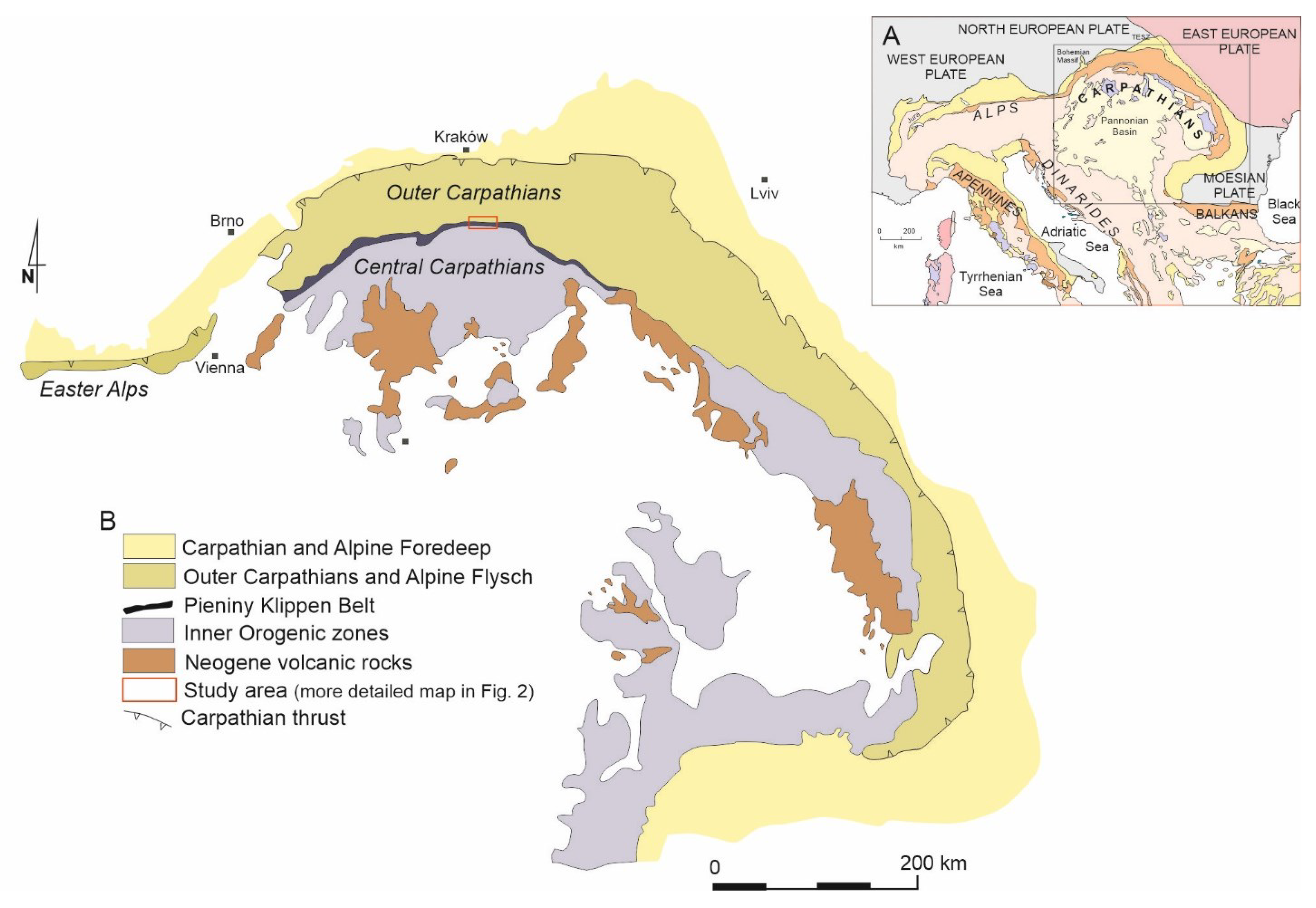
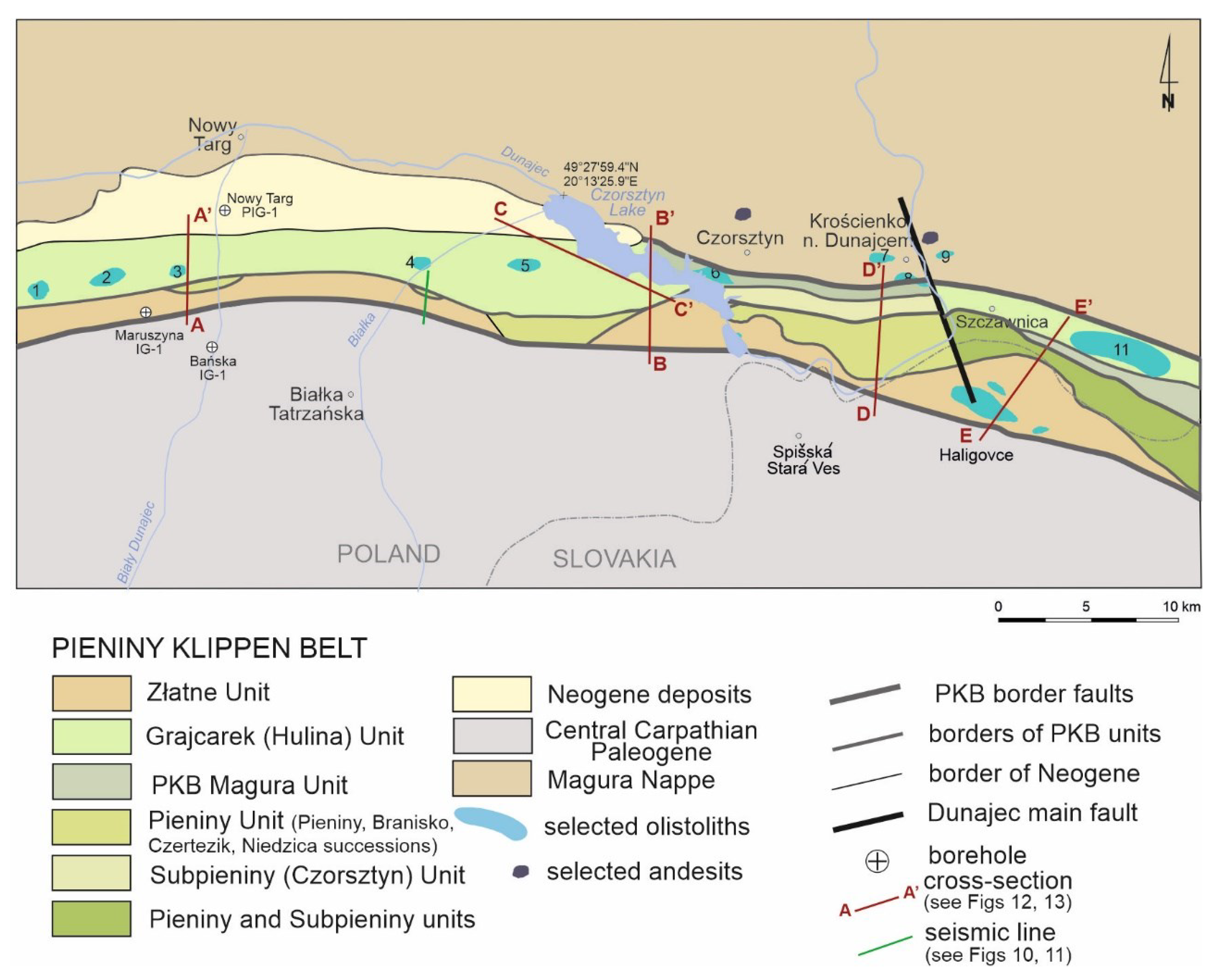
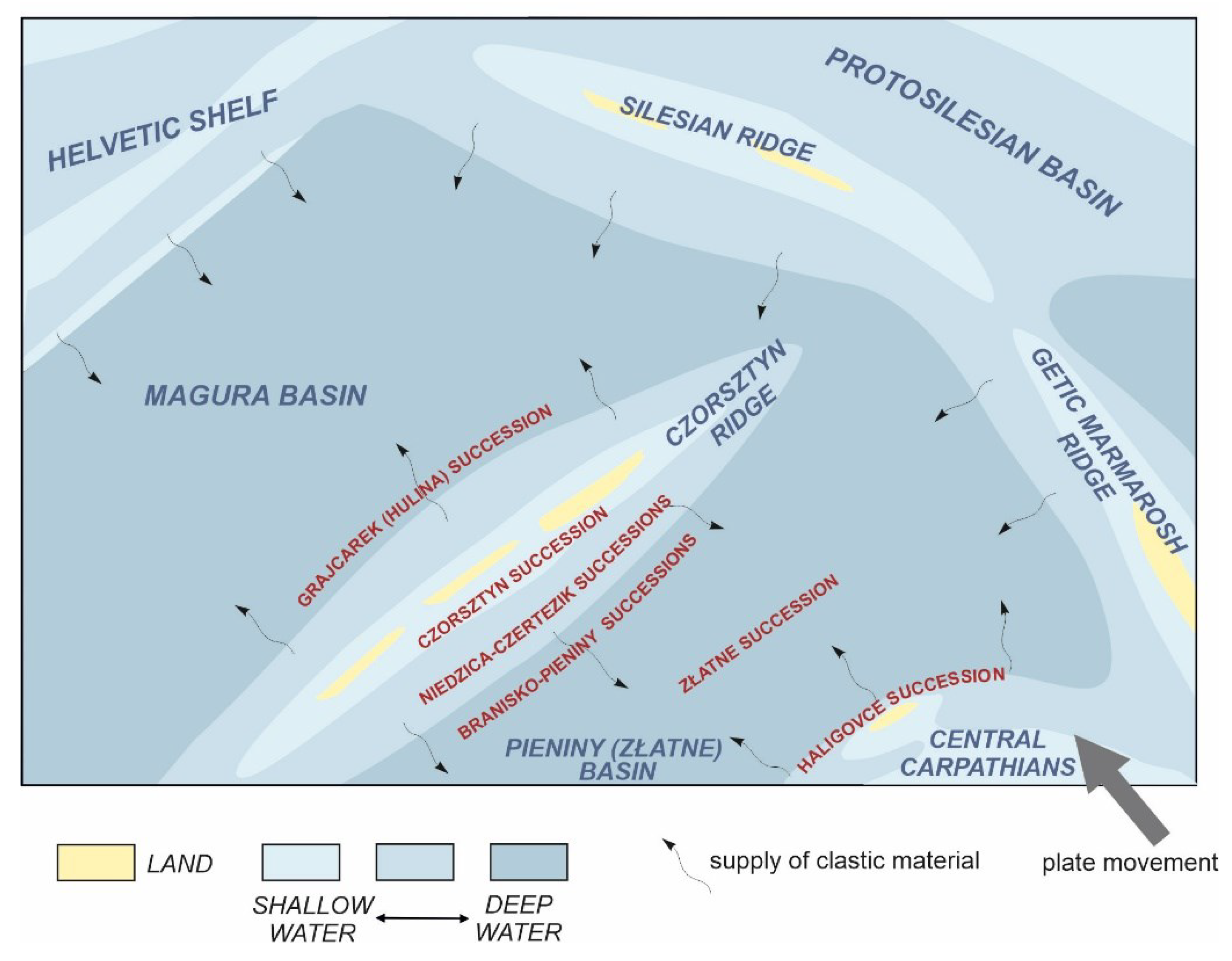
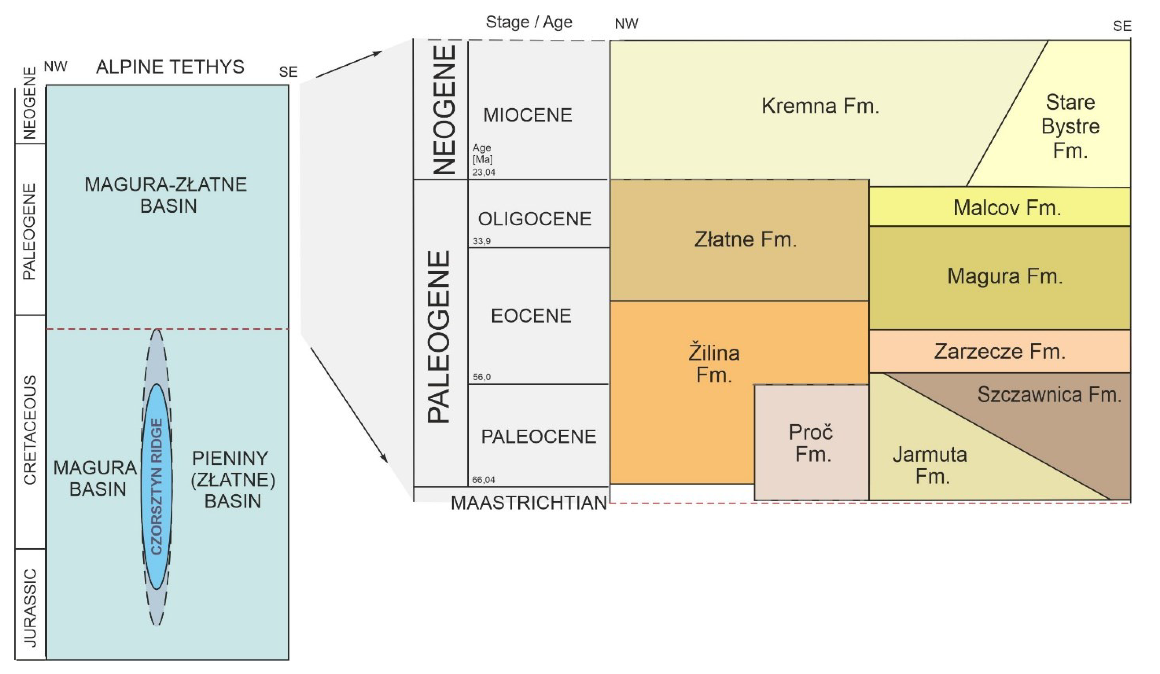
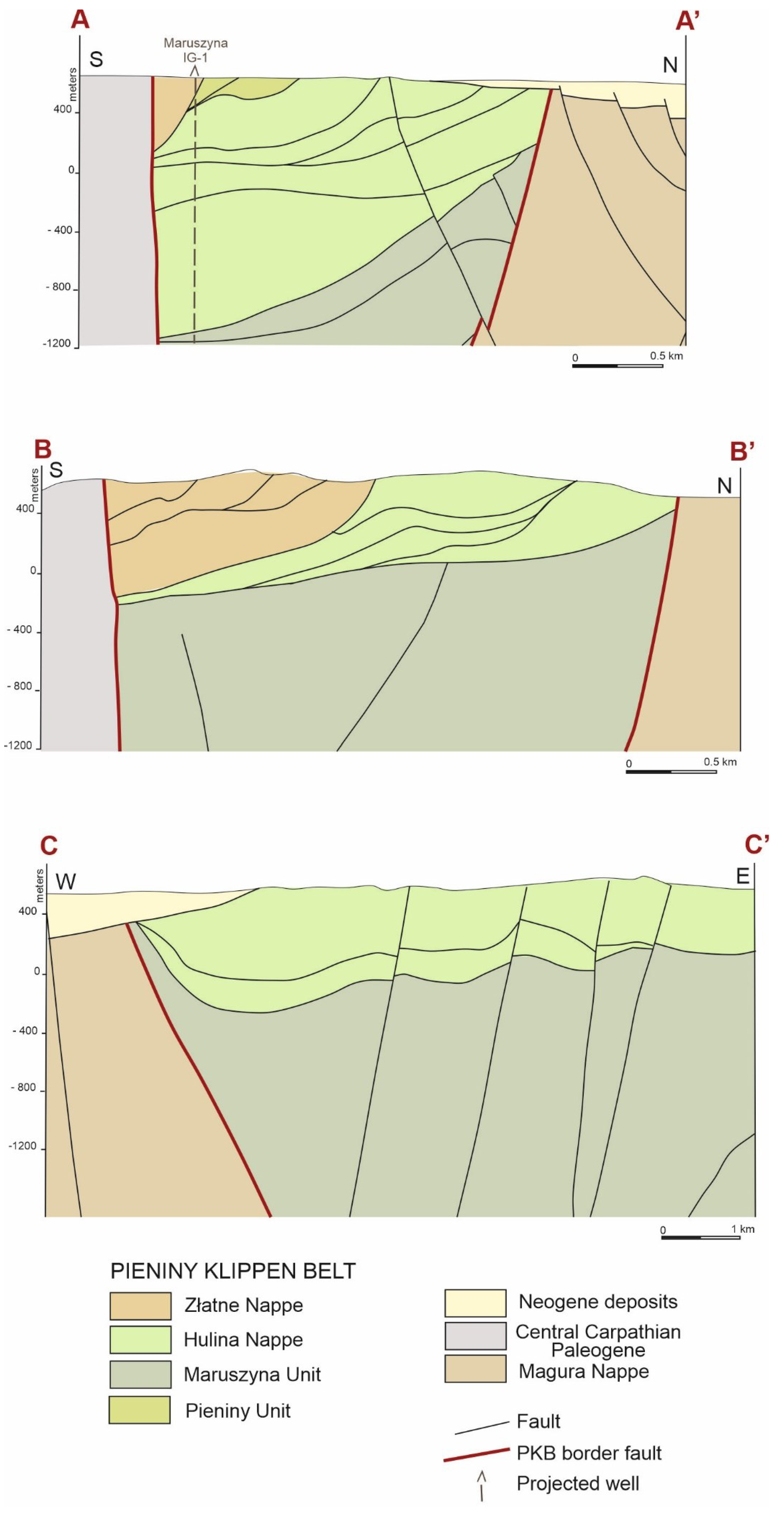
2. Geological Setting and Paleogeography
3. Methods
4. Results
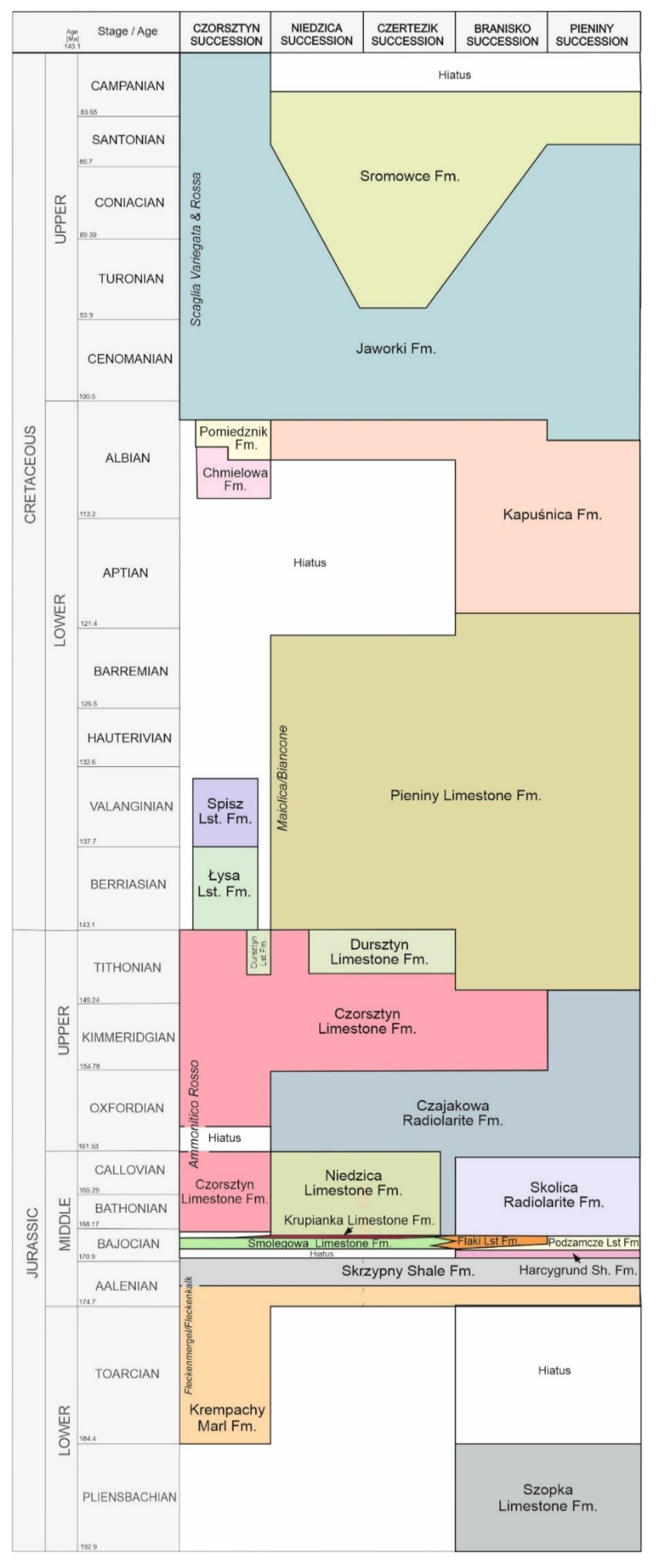
4.1. Stratigraphy
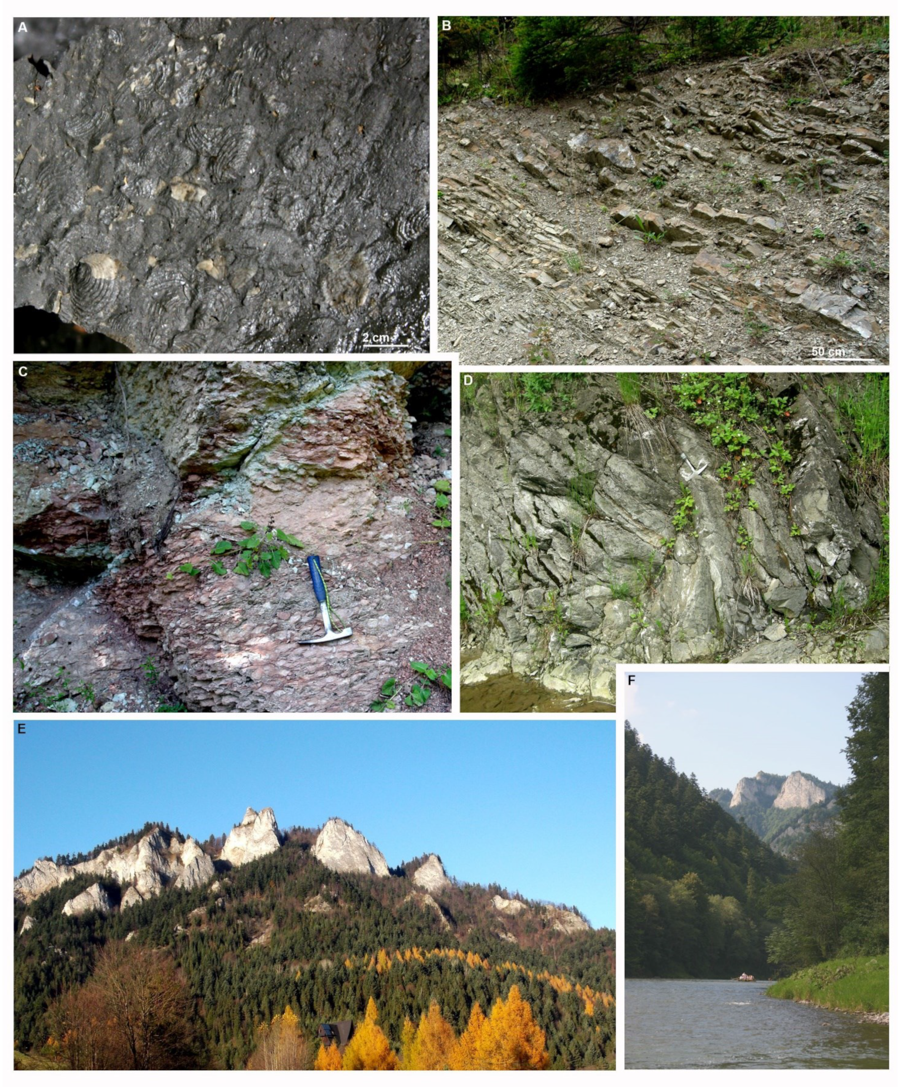
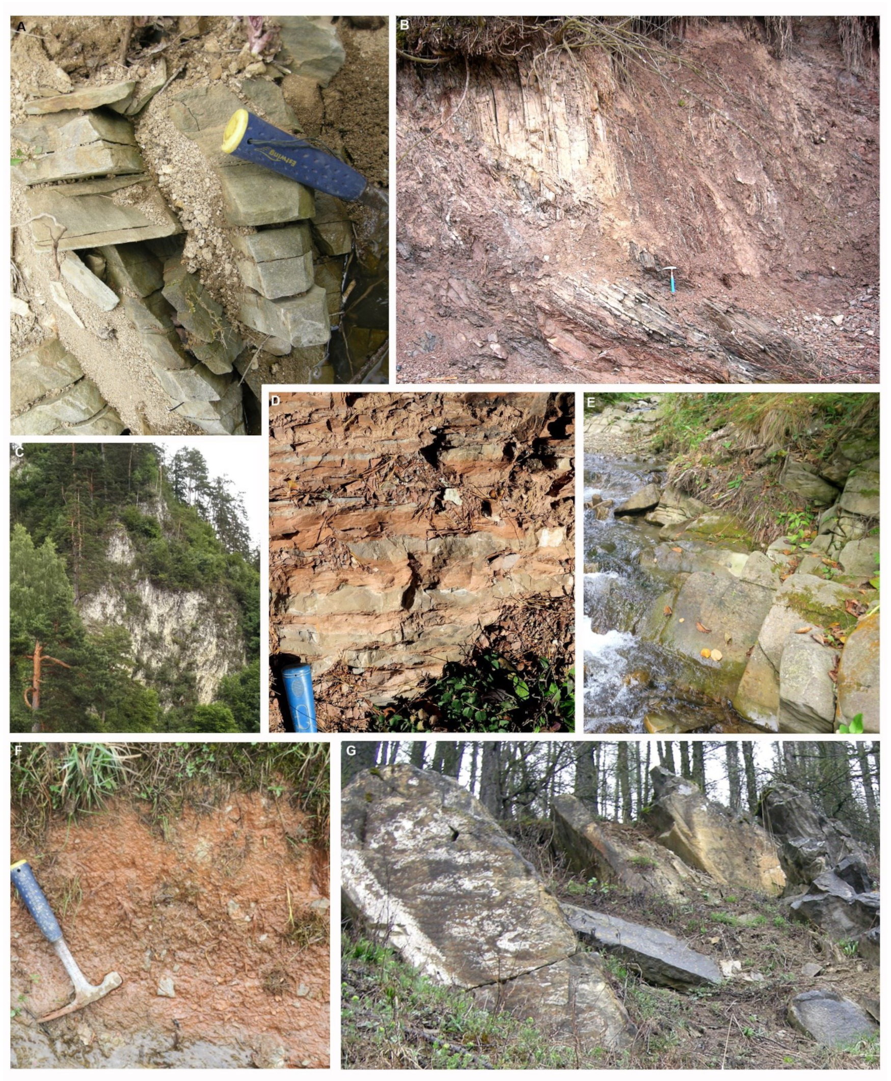
4.1.1. Basinal Successions


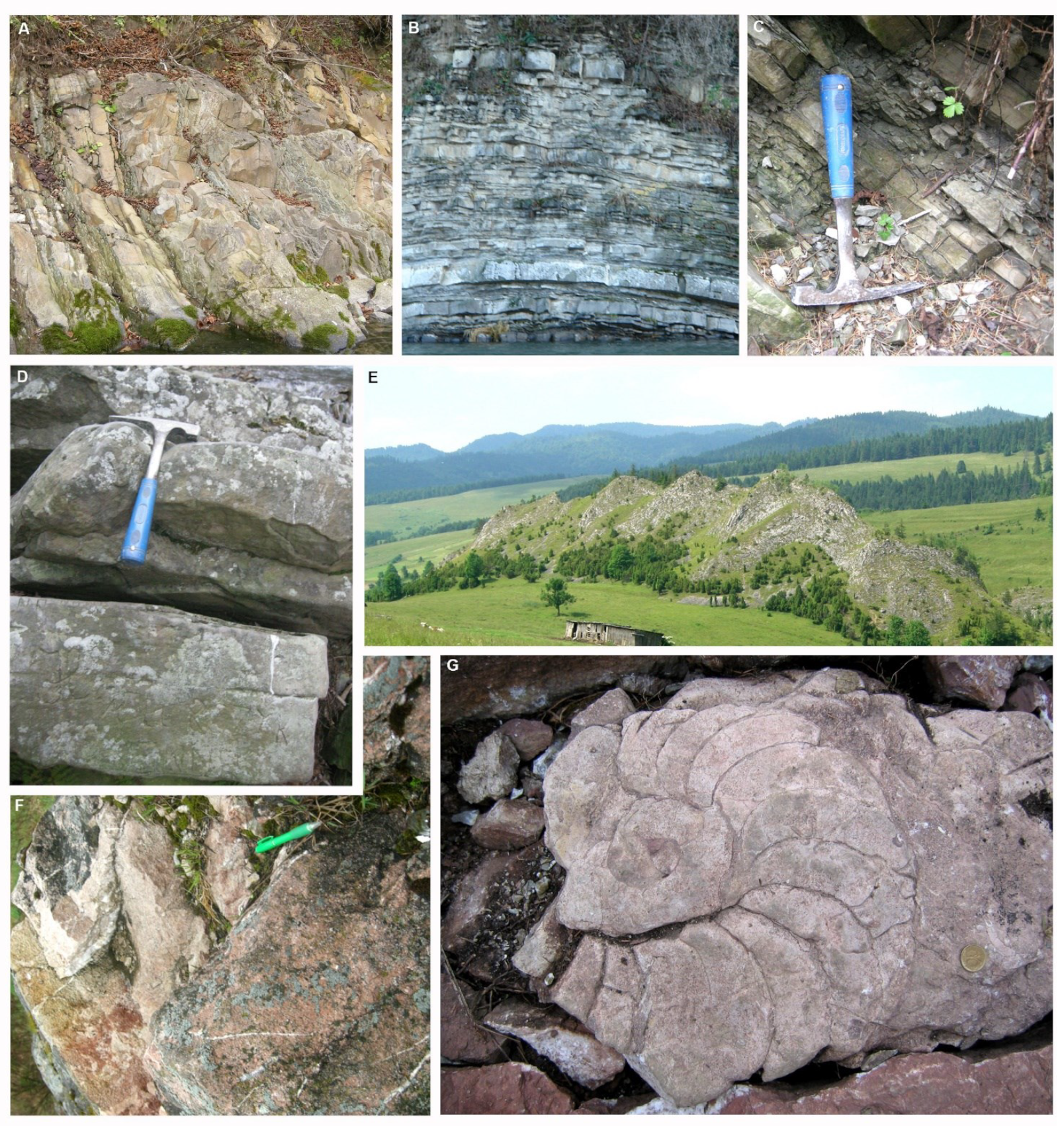
4.1.2. Czorsztyn Ridge and Slope Successions
4.1.3. Southern Slope Succession
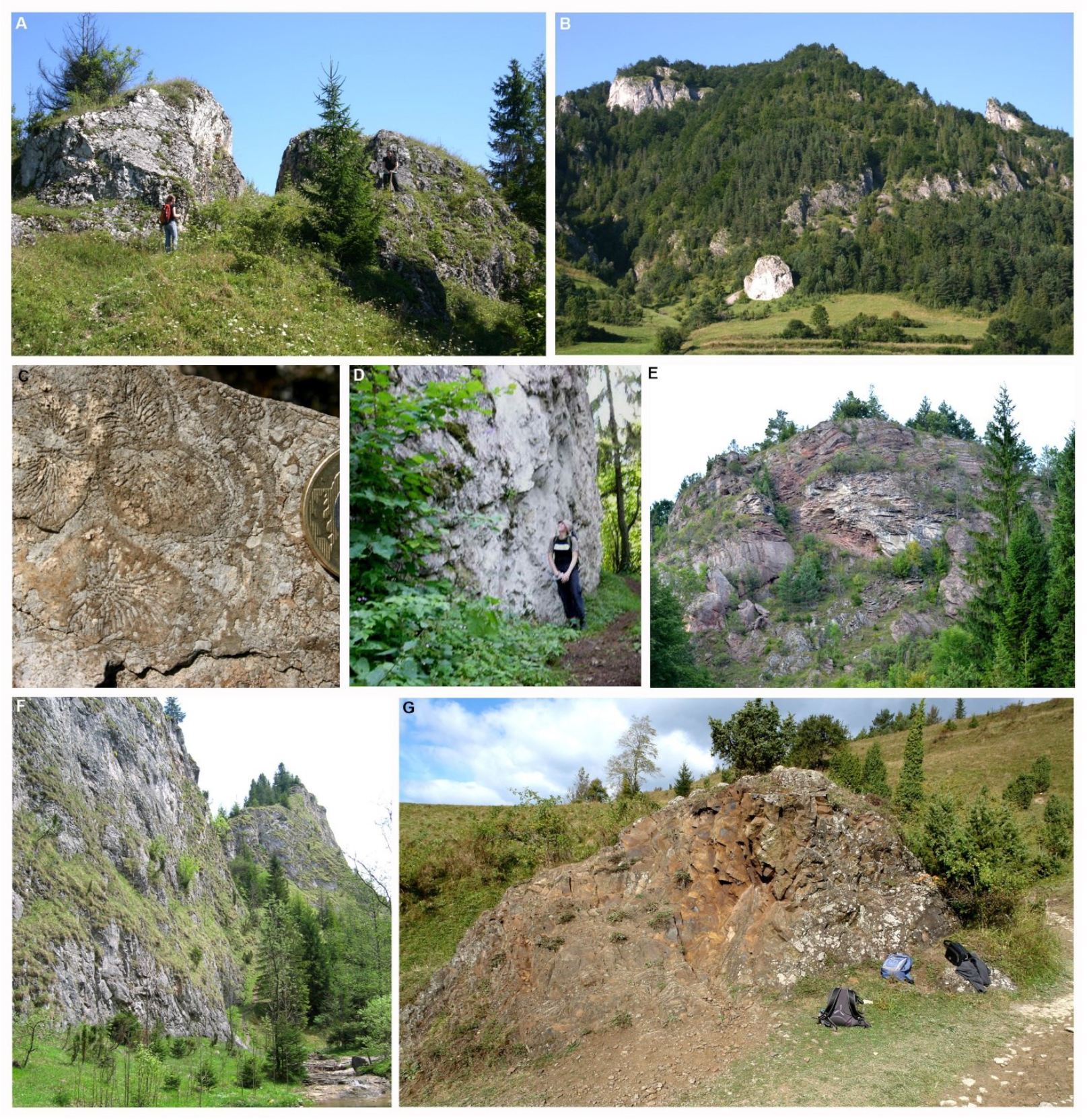
4.2. Pieniny Klippen Belt Mélange
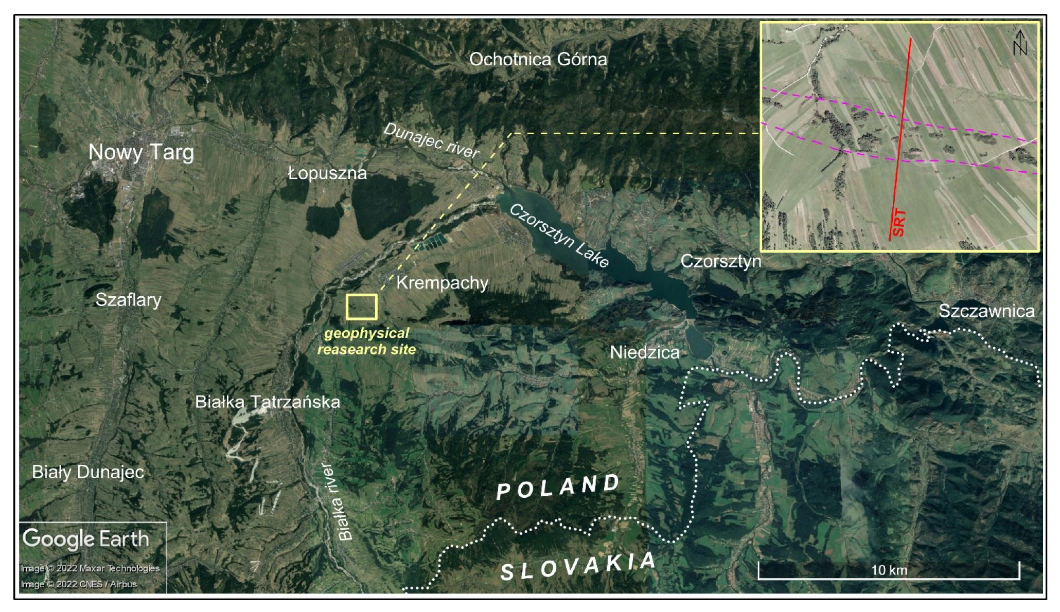
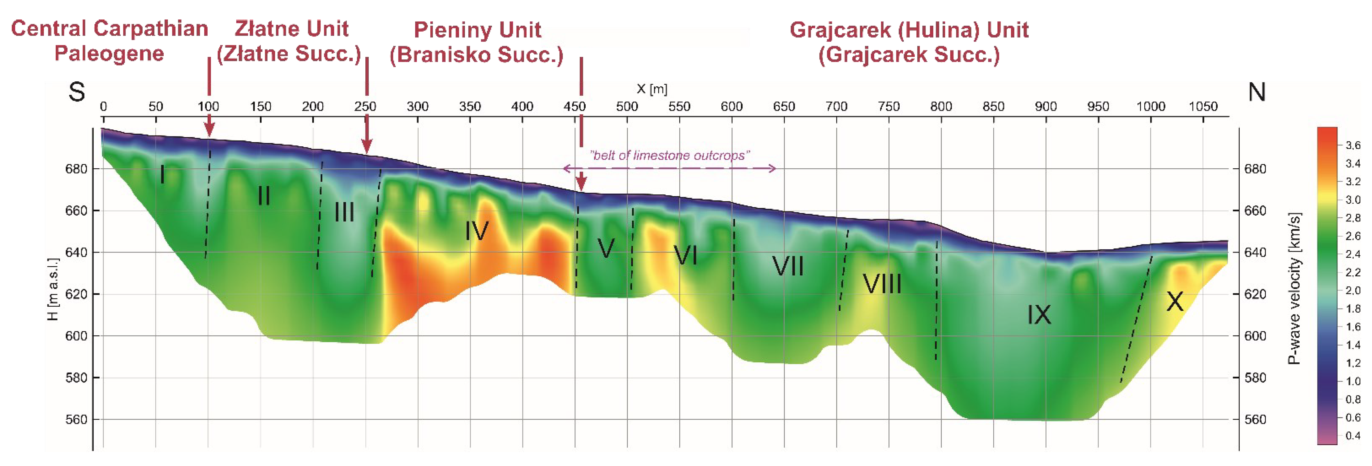
4.3. PKB Mélange in the Seismic Image—Preliminary Results of SRT Research
5. Discussion
6. Conclusions
Author Contributions
Funding
Data Availability Statement
Acknowledgments
Conflicts of Interest
References
- Książkiewicz, M. Karpaty. In Budowa Geologiczna Polski, T. 4. Tektonika, Cz. 3; Pożaryski, W., Ed.; Wydawnictwa Geologiczne: Warszawa, Poland, 1972; pp. 1–282. [Google Scholar]
- Książkiewicz, M. Tectonics of the Carpathians. In Geology of Poland. Vol. IV. Tectonics; Pożaryski, W., Ed.; Wydawnictwa Geologiczne: Warszawa, Poland, 1977; pp. 476–604. [Google Scholar]
- Golonka, J.; Pietsch, K.; Marzec, P.; Kasperska, M.; Dec, J.; Cichostępski, K.; Lasocki, S. Deep structure of the Pieniny Klippen Belt in Poland. Swiss J. Geosci. 2019, 112, 475–506. [Google Scholar] [CrossRef]
- Golonka, J.; Gawęda, A.; Waśkowska, A. Carpathians. In Encyclopedia of Geology, 2nd ed.; Alderon, D., Elias, S.A., Eds.; Elsevier: Amsterdam, The Netherlands, 2021; pp. 372–381. [Google Scholar] [CrossRef]
- Golonka, J.; Pietsch, K.; Marzec, P. The North European Platform suture zone in Poland. Geol. Geophys. Environ. 2018, 44, 5–16. [Google Scholar] [CrossRef]
- Csontos, L.; Nagymarosy, A.; Horvat, F.; Kováč, M. Tertiary evolution of the Intra-Carpathian area: A model. Tectonophysics 1992, 208, 221–241. [Google Scholar] [CrossRef]
- Csontos, L.; Vörös, A. Mesozoic plate tectonic reconstruction of the Carpathian region. Palaeogeogr Palaeoclimatol. Palaeoecol. 2004, 210, 1–56. [Google Scholar] [CrossRef]
- Birkenmajer, K. Przełom Dunajca w Pieninach—fenomen geologiczny. Pienin. Przyr. I Człowiek 2006, 9, 9–22, (in Polish with English summary). [Google Scholar]
- Golonka, J.; Krobicki, M. Dunajec River rafting as one of the most important geotouristic object of the future trans-bordering PIENINY Geopark. Geotourism 2007, 3, 29–44. [Google Scholar]
- Wierzbowski, A.; Aubrecht, R.; Golonka, J.; Gutowski, J.; Krobicki, M.; Matyja, B.A.; Pieńkowski, G.; Uchman, A. Jurassic of Poland and adjacent Slovakian Carpathians. Field trip guidebook. In Proceedings of the 7th International Congress on the Jurassic System, Kraków, Poland, 6–18 September 2006; pp. 3–235. [Google Scholar]
- Golonka, J.; Krobicki, M.; Waśkowska, A. The Pieniny Klippen Belt in Poland. Geol. Geophys. Environ. 2018, 44, 111–125. [Google Scholar] [CrossRef]
- Jurewicz, E. The Šariš Transitional Zone, revealing interactions between Pieniny Klippen Belt, Outer Carpathians and European platform. Swiss J. Geosci. 2018, 111, 245–267. [Google Scholar] [CrossRef]
- Greenly, E. The Geology of Anglesey: Memoirs of Geological Survey; HM Stationary Office: London, UK, 1919; Volumes I and II, pp. 1–388. [Google Scholar]
- Hsü, K.J. Principles of mélanges and their bearing on the Franciscan-Knoxville paradox. Geol. Soc. Am. Bull. 1968, 79, 1063–1074. [Google Scholar] [CrossRef]
- Festa, A.; Dilek, Y.; Pini, G.; Codegone, G.; Ogata, K. Mechanisms and processes of stratal disruption and mixing in the development of mélanges and broken formations: Redefining and classifying mélanges. Tectonophysics 2012, 568, 7–24. [Google Scholar] [CrossRef]
- Hsü, K.J. Mélanges and their distinction from olistostrome. Spec. Publ. Soc. Econ. Paleontol. Mineral. Tulsa 1974, 19, 321–333. [Google Scholar]
- Abbate, E.; Bortolotti, V.; Passerini, P. Olistostromes and olistolites. Sediment. Geol. 1970, 4, 521–557. [Google Scholar] [CrossRef]
- Elter, P.; Trevisan, L. Olistostromes and the tectonic evolution of the Northern Apennines. In Gravity and Tectonics; de Jong, A.K., Scholten, R., Eds.; John Wiley: New York, NY, USA, 1973; pp. 175–188. [Google Scholar]
- Naylor, M.A. Debris flow (olistostromes) and slumping on a distal passive continental margin: The Palombini limestone-shale sequence of the northern Apennines. Sedimentology 1981, 28, 837–852. [Google Scholar] [CrossRef]
- Pini, G.A. Tectonosomes and olistostromes in the Argille Scagliose of the Northern Apennines, Italy. Geol. Soc. Am. Spec. Pap. 1999, 335, 1–73. [Google Scholar]
- Trümpy, R. Geologie der Iberger Klippen und ihrer Flysch-Unterlage. Eclogae Geol. Helv. 2006, 99, 79–121. [Google Scholar] [CrossRef]
- Camerlenghi, A.; Pini, G.A. Mud volcanoes, olistostromes and Argille scagliose in the Mediterranean region. Sedimentology 2009, 56, 319–365. [Google Scholar] [CrossRef]
- Golonka, J.; Krobicki, M.; Waśkowska, A.; Cieszkowski, M.; Ślączka, A. Reply. Discussion of ‘Olistostromes of the Pieniny Klippen Belt, Northern Carpathians’. Geol. Mag. 2017, 154, 193–200. [Google Scholar] [CrossRef]
- Plašienka, D.; Michalík, J.; Soták, J.; Aubrech, R. Discussion of “Olistostromes of the Pieniny Klippen Belt, Northern Carpathians”. Geol. Mag. 2017, 154, 187–192. [Google Scholar] [CrossRef]
- Jankowski, L. Od podnóża Tatr po brzeg Karpat, Współczesne wyzwania kartografii geologicznej. In Warsztaty terenowe, Konferencja naukowo-szkoleniowa, Kraków/Szczawnica, 17-20.09.2019; Państwowy Instytut Geologiczny—Państwowy Instytut Badawczy: Warsaw, Poland, 2019; (In Polish only). [Google Scholar]
- Jurewicz, E.; Segit, T.; Plašienka, D.; Chrapkiewicz, K. Seismic imaging of mélanges—Pieniny Klippen Belt case study. Discussion. J. Geol. Soc. 2021, 178, 629–646. [Google Scholar] [CrossRef]
- Marzec, P.; Golonka, J.; Pietsch, K.; Kasperska, M.; Dec, J.; Cichostępski, K.; Lasocki, S. Reply to Discussion of ‘Seismic imaging of mélanges; Pieniny Klippen Belt case study’. J. Geol. Soc. 2021, 178, 2020–2111. [Google Scholar] [CrossRef]
- Kováč, M.; Nagymarosy, A.; Oszczypko, N.; Ślączka, A.; Csontos, L.; Marunteanu, M.; Matenco, L.; Márton, M. Palinspastic reconstruction of the Carpathian-Pannonian region during the Miocene. In Geodynamic Development of the Western Carpathians. Geological Survey of Slovac Republic; Rakús, M., Ed.; Dionýz Štúr Publishers: Bratislava, Slovakia, 1998; pp. 189–217. [Google Scholar]
- Neumayr, M. Jurastudien. Der penninische Klippenzug. Jahrb. Geolog. Reichsan. 1871, 21, 451–536. [Google Scholar]
- Kondracki, J. Geografia Regionalna Polski; Polish Science Press: Warsaw, Poland, 2001; pp. 1–446. [Google Scholar]
- Andrusov, D. Geologie der Tschechoslowakischen Karpaten; Berlin Akademie-Verl.: Berlin, Germany, 1965; pp. 1–443. [Google Scholar]
- Birkenmajer, K. Jurassic and Cretaceous lithostratigraphic units of the Pieniny Klippen Belt, Carpathians, Poland. Stud. Geol. Pol. 1977, 45, 1–158. [Google Scholar]
- Birkenmajer, K. Stages of structural evolution of the Pieniny Klippen Belt, Carpathians. Stud. Geol. Pol. 1986, 88, 7–32. [Google Scholar]
- Birkenmajer, K. Exotic Andrusov Ridge: Its role in plate-tectonic evolution of the West Carpathian Foldbelt. Stud. Geol. Pol. 1988, 91, 7–37. [Google Scholar]
- Mišík, M. The Czorsztyn submarine ridge (Jurassic-Lower Cretaceous, Pieniny Klippen Belt): An example of a pelagic swell. Mitt. Der Sterreichische Geol. Ges. 1994, 86, 133–140. [Google Scholar]
- Sikora, W. New data on the geology of the Pieniny Klippen Belt. Bull. Pol. Acad. Sci. Earth Sci. 1962, 10, 203–211. [Google Scholar]
- Sikora, W. Esquisse de la tectogénèse de la zone des Klippes des Pieniny en Pologne d’après de nouvelles données géolgiques. Rocz. Pol. Tow. Geol. 1971, 4, 221–239. [Google Scholar]
- Wierzbowski, A.; Aubrecht, R.; Krobicki, M.; Matyja, B.A.; Schlögl, J. Stratigraphy and palaeogeographic position of the Jurassic Czertezik Succession, Pieniny Klippen Belt (Western Carpathians) of Poland and Eastern Slovakia. Ann. Soc. Geol. Pol. 2004, 74, 237–256. [Google Scholar]
- Golonka, J.; Krobicki, M. Jurassic paleogeography of the Pieniny and Outer Carpathian basins. Riv. Ital. Paleont. Stratig. 2004, 110, 5–14. [Google Scholar]
- Schmid, S.M.; Bernoulli, D.; Fugenschuh, B.; Matenco, L.; Schefer, S.; Schuster, R.; Tischler, M.; Ustaszewski, K. The Alpine–Carpathian–Dinaridic orogenic system: Correlation and evolution of tectonic units. Swiss Jour. Geosc. 2008, 101, 139–183. [Google Scholar] [CrossRef]
- Golonka, J.; Krobicki, M.; Waśkowska, A.; Cieszkowski, M.; Ślączka, A. Olistostromes of the Pieniny Klippen Belt, Northern Carpathians. Geol. Mag. 2015, 152, 269–286. [Google Scholar] [CrossRef]
- Sikora, W. The Pieniny Klippen Belt (Polish Carpathians). In Tectonics of the Carpathian-Balkan Regions; Mahel, M., Ed.; Geological Institute of D. Štur.: Bratislava, Slovakia, 1974; pp. 177–180. [Google Scholar]
- Oszczypko, N.; Ślączka, A.; Oszczypko–Clowes, A.; Olszewska, B. Where was the Magura Ocean. Acta Geol. Pol. 2015, 65, 319–344. [Google Scholar] [CrossRef]
- Golonka, J.; Waśkowska, A.; Ślączka, A. The Western Outer Carpathians: Origin and evolution. Z. Der Dtsch. Ges. Für Geowiss. 2019, 170, 229–254. [Google Scholar] [CrossRef]
- Watycha, L. Szczegółowa Mapa Geologiczna Polski 1:50.000. (bez utworów Czwartorzędowych). Rejon Karpat i Przedgórza. Arkusz Krościenko; Wydawnictwa Geologiczne: Warszawa, Poland, 1964. (In Polish) [Google Scholar]
- Watycha, L. Szczegółowa Mapa Geologiczna Polski 1:50.000. (bez utworów Czwartorzędowych). Rejon Karpat i Przedgórza. Arkusz Nowy Targ; Wydawnictwa Geologiczne: Warszawa, Poland, 1964. (In Polish) [Google Scholar]
- Watycha, L. Szczegółowa Mapa Geologiczna Polski 1:50 000, Arkusz Nowy Targ; Wydawnictwa Geologiczne: Warszawa, Poland, 1975. (In Polish) [Google Scholar]
- Sikora, W.; Borysławski, A.; Cieszkowski, M.; Gucik, S.; Jasionowicz, J. Geological Cross-Section Cracow-Zakopane; Wydawnictwa Geologiczne: Warszawa, Poland, 1980. (In Polish) [Google Scholar]
- Kulka, A.; Rączkowski, W.; Żytko, K.; Paul, Z. Szczegółowa Mapa Geologiczna Polski. 1:50.000. Arkusz Szczawnica-Krościenko. Detailed Geological Map of Poland, Szczawnica-Krościenko Sheet; Wydawnictwa Geologiczne: Warszawa, Poland, 1985. (In Polish) [Google Scholar]
- Birkenmajer, K.; Pécskay, Z. K-Ar dating of the Miocene andesite intrusions, Pieniny Mts. Bull. Pol. Acad. Sci. Earth Sci. 1999, 47, 155–169. [Google Scholar]
- Jurewicz, E.; Nejbert, K. Geotectonic position of the so-called “Pieniny Mts. andesites”. Mineral. Soc. Pol. Spec. Pap. 2005, 25, 179–183. [Google Scholar]
- Nejbert, K.; Jurewicz, E.; Macdonald, R. Potassium-rich rocks in the Western Outer Carpathians: Magmagenesis in transitional zone between European Plate and the Carpathian-Pannonian regions. Lithos 2012, 146–147, 34–47. [Google Scholar] [CrossRef]
- Anczkiewicz, A.A.; Anczkiewicz, R. U–Pb zircon geochronology and anomalous Sr–Nd–Hf isotope systematics of late orogenic andesites: Pieniny Klippen Belt, Western Carpathians, South Poland. Chem. Geol. 2016, 427, 1–16. [Google Scholar] [CrossRef]
- Nemčok, M.; Nemčok, J. Late Cretaceous deformation of the Pieniny Klippen Belt, West Carpathians. Tectonophysics 1994, 239, 81–109. [Google Scholar] [CrossRef]
- Krobicki, M.; Golonka, J.; Kołodziej, B.; Olszewska, B.; Oszczypko, N.; Słomka, T.; Tragelehn, H.; Wieczorek, J. Paleoceńskie olistolity wapieni koralowo-glonowych rejonu Haligowiec (pieniński pas skałkowy, Słowacja). In Egzotyki Karpackie—Znaczenie W Rekonstrukcjach Paleogeograficzno-Geotektonicznych; Krobicki, M., Ed.; Ogólnopolskie Seminarium: Kraków, Poland, 2004; pp. 53–55, (In Polish only). [Google Scholar]
- Cieszkowski, M.; Golonka, J.; Krobicki, M.; Ślączka, A.; Oszczypko, N.; Waśkowska, A.; Wendorff, M. The Northern Carpathians plate tectonic evolutionary stages and origin of olistoliths and olistostromes. Geod. Acta 2009, 22, 101–126. [Google Scholar] [CrossRef]
- Białoń, W.; Lizurek, G.; Dec, J.; Cichostępski, K.; Pietsch, K. Relocation of Seismic Events and Validation of Moment Tensor Inversion for SENTINELS Local Seismic Network. Pure Appl. Geophys. 2019, 176, 4701–4728. [Google Scholar] [CrossRef]
- Marzec, P.; Golonka, J.; Pietsch, K.; Kasperska, M.; Dec, J.; Cichostępski, K.; Lasocki, S. Seismic imaging of mélanges—Pieniny Klippen Belt case study. J. Geol. Soc. 2020, 177, 629–646. [Google Scholar] [CrossRef]
- White, D.J. Two-dimensional seismic refraction tomography. Geophys. J. Int. 1989, 97, 223–245. [Google Scholar] [CrossRef]
- Birkenmajer, K.; Jednorowska, A. Late Cretaceous foraminiferal biostratigraphy of the Pieniny Klippen Belt, Carpathians (Poland). Studia Geol. Pol. 1987, 92, 7–28. [Google Scholar]
- Krobicki, M.; Wierzbowski, A. Pozycja stratygraficzna i paleogeograficzne znaczenie bajoskich wapieni krynoidowych w ewolucji pienińskiego basenu skałkowego. Vol. Juras. 2004, 2, 69–82. [Google Scholar]
- Krobicki, M. Duration of the Czorsztyn Ridge uplift (Pieniny Klippen Belt, Carpathians) during the Early Bajocian time. In Proceedings of the Environmental, Structural and Stratigraphical Evolution of the Western Carpathians, Abstract Book, 11th ESSEWECA Conference, Bratislava, 29–30 November 2018; Šujan, M., Csibri, T., Kiss, P., Rybár, S., Eds.; The Publishing House of the Comenius University in Bratislava: Bratislava, Slovakia, 2018; pp. 50–51. [Google Scholar]
- Birkenmajer, K. The Szopka Limestone Formation—A new lithostratigraphic name for Upper Liassic beds of the Pieniny and Branisko successions, Pieniny Klippen Belt (West Carpathians). Studia Geol. Pol. 2008, 131, 229–235. [Google Scholar]
- Krobicki, M.; Wierzbowski, A. Middle Jurassic nodular limestones of the Czertezik Succession of the Pieniny Klippen Basin of Poland—Facts and controversies. Przegląd Geol. 2009, 57, 600–606. [Google Scholar]
- Gradstein, F.M.; Ogg, J.G.; Schmitz, M.D.; Ogg, G.M. Geologic Time Scale 2020; Elsevier: Amsterdam, The Netherlands, 2020. [Google Scholar]
- Oszczypko, N.; Oszczypko–Clowes, M. Geological structure and evolution of the Pieniny Klippen Belt to the east of the Dunajec River—A new approach (Outer Western Carpathians, Poland). Geol. Q. 2014, 58, 737–758. [Google Scholar]
- Bąk, K.; Uchman, A.; Bąk, M. Agglutinated foraminifera, radiolaria and trace fossils from Upper Cretaceous Deep-Water Variegated Shales at Trawne Stream, Grajcarek Unit, Pieniny Klippen Belt, Carpathians, Poland. Bull. Pol. Acad. Sci. Earth Sci. 2000, 48, 1–32. [Google Scholar]
- Oszczypko, N.; Olszewska, B.; Malata, E. Cretaceous (Aptian/Albian–Cenomanian) age of “black flysch”and adjacent deposits of the Grajcarek thrust–sheets in the Małe Pieniny Mts. (Pieniny Klippen Belt, Polish Outer Carpathians). Geol. Q. 2012, 56, 411–440. [Google Scholar] [CrossRef]
- Birkenmajer, K.; Gedl, P. The Grajcarek Succession (Lower Jurassic–mid Paleocene) in the Pieniny Klippen Belt, West Carpathians, Poland: A stratigraphic synthesis. Ann. Soc. Geol. Pol. 2017, 87, 55–88. [Google Scholar] [CrossRef]
- Birkenmajer, K.; Oszczypko, N. Cretaceous and Palaeogene lithostratigraphic units of the Magura nappe, Krynica subunit, Carpathians. Ann. Soc. Geol. Pol. 1989, 59, 145–181. [Google Scholar]
- Ślączka, A.; Kruglov, S.; Golonka, J.; Oszczypko, N.; Popadyuk, I. The general geology of the Outer Carpathians, Poland, Slovakia, and Ukraine. In The Carpathians and Their Foreland: Geology and Hydrocarbon Resources. American Association of Petroleum Geologists, Memoir; Golonka, J., Picha, F., Eds.; AAPG: Tulsa, OK, USA, 2006; Volume 84, pp. 221–258. [Google Scholar]
- Golonka, J.; Waśkowska, A. Paleogene of the Magura Nappe adjacent to the Pieniny Klippen Belt between Szczawnica and Krościenko (Outer Carpathians, Poland). Geol. Geophys. Environ. 2014, 40, 359–376. [Google Scholar] [CrossRef]
- Paul, C.M. Die nordliche Arva. Jahrb. Geolog. Reichsan. 1868, 18, 201–280. [Google Scholar]
- Cieszkowski, M.; Olszewska, B. Malcov beds in the Magura Nappe near Nowy Targ, Outer Carpathians, Poland. Ann. Soc. Geol. Pol. 1986, 56, 53–71. [Google Scholar]
- Cieszkowski, M. Marine Miocene deposits near Nowy Targ, Magura Nappe, Flysch Carpathians (South Poland). Geol. Carpathica 1992, 43, 339–346. [Google Scholar]
- Oszczypko, N.; Oszczypko–Clowes, M. The Paleogene and Early Negene stratigraphy of the Beskid Sądecki Range and Lubovnianska Vrchovina (Magura Nappe, Western Outer Carpathians). Acta Geol. Pol. 2010, 60, 317–348. [Google Scholar]
- Kaczmarek, A.; Oszczypko–Clowes, M.; Cieszkowski, M. Early Miocene age of Stare Bystre Formation (Magura Nappe, Outer Carpathians, Poland) indicated by the calcareous nannoplankton. Geol. Q. 2016, 60, 341–354. [Google Scholar]
- Wierzbowski, A.; Wierzbowski, H.; Segit, T.; Krobicki, M. Jurassic evolution and the structure of the central part of the Pieniny Klippen Belt (Carpathians) in Poland—New insight from the Czertezik Succession type area. Vol. Jurass. 2021, 19, 21–60. [Google Scholar] [CrossRef]
- Golonka, J.; Krobicki, M. Upwelling regime in the Carpathian Tethys from the Jurassic-Cretaceous paleogeographic and paleoclimatic perspectives. Geol. Q. 2001, 45, 15–32. [Google Scholar]
- Krobicki, M.; Olszewska, B. Urgonian-type microfossils in exotic pebbles of the Late Cretaceous and Palaeogene gravelstones from the Sromowce and Jarmuta formations (Pieniny Klippen Belt, Polish Carpathians). Studia Geol. Pol. 2005, 124, 215–235. [Google Scholar]
- Birkenmajer, K. Significance of the Haligovce Klippe for the geology of the Pieniny Klippen-Belt (Carpathians). Rocz. Pol. Tow. Geol. 1959, 29, 73–88, (In Polish, English summary). [Google Scholar]
- Horwitz, L.; Rabowski, F. Przewodnik do wycieczki Polskiego Towarzystwa Geologicznego w Pieniny (18–21.V.1929). Rocz. Pol. Tow. Geol. 1930, 6, 1–49. [Google Scholar]
- Birkenmajer, K. Preliminary revision of the stratigraphy of the Pieniny Klippen-Belt Series in Poland. Bull. Int. Acad. Polon. Sci. 1953, 1, 271–274. [Google Scholar]
- Matějka, A. On the Haligovce Mesozoic and Paleogene. In Zprávy o Geologických Výzkumech v Roce 1959; ÚÚG Praha: Prague, Czechoslovakia, 1961; pp. 129–130. [Google Scholar]
- Janočko, J. Explanations to the geological map of the Spišská Magura Mts. 1:50,000. In Geological Survey of Slovakia; Štúr Publisher: Bratislava, Slovakia, 2000. [Google Scholar]
- Potfaj, M. The saddle between Haligovce and Lesnica. Guide to geological excursions. In Proceedings of the XVII th Carpathian-Balkan Geological Association (CBGA) Congress, Bratislava, Slovakia, 1–4 September 2002; pp. 1–4. [Google Scholar]
- Ludwiniak, M. Miocene transpression effects at the boundary of Central Carpathian Paleogene Basin and PieninyKlippen Belt: Examples from Polish-Slovakian borderland. Geol. Geophys. Environ. 2018, 44, 91–110. [Google Scholar] [CrossRef]
- Buček, S.; Köhler, E. Palaeocene reef complex of the Western Carpathians. Slovak Geol. Mag. 2017, 17, 3–163. [Google Scholar]
- Barber, A.J.; Yjokrosapoetro, S.; Charlton, T.R. Mud volcanoes, shale diapirs, wrench faults and melanges in accretionary complexes, Eastern Indonesia. AAPG Bull. 1986, 70, 1729–1741. [Google Scholar]
- Balance, P.F. Gravity flows and rock recycling on the Tonga landward trench slope: Relation to trench-slope tectonic processes. J. Geol. 1991, 99, 817–827. [Google Scholar] [CrossRef]
- Duperret, A.; Bourgois, J.; Lagabrielle, Y.; Suess, E. Slope instability at an active continental margin: Large-scale polyphase submarine slides along the Peruvian margin, between 5° S and 6° S. Mar. Geol. 1995, 122, 303–328. [Google Scholar] [CrossRef]
- McAdoo, B.G.; Pratson, L.F.; Orange, D.L. Submarine landslide geomorphology, US continental slope. Mar. Geol. 2000, 169, 103–136. [Google Scholar] [CrossRef]
- Mosher, D.C.; Shipp, R.C.; Moscardelli., L.; Chaytor, J.D.; Baxter, C.D.P.; Lee, H.J.; Urgeles., R. Submarine Mass Movements and Their Consequences: 4th International Symposium; Advances in Natural and Technological Hazards Research; Springer: Dodrecht, The Netherlands, 2010; Volume 28, p. 786. [Google Scholar]
- Yamada, Y.; Kawamura, Y.; Ikehara, K.; Ogawa, Y.; Urgeles, R.; Mosher, D.; Chaytor, J.; Strasser, M. Submarine Mass Movements and Their Consequences: 5th International Symposium; Advances in Natural and Technological Hazards Research; Springer: Dodrecht, The Netherlands, 2012; Volume 31, p. 769. [Google Scholar]
- Richter, D. Olisthostrom, Olistholit, Olisthorymma und Olisthoplaka als Merkmale von Gleistungs-und Resedimentationsvorgangen infolge synsedimentarer tectogenetischer Bewengungen in Geosynklinalbereichen. Neues Jahrb. Fuer Geol. Palaeontol. Abh. 1973, 143, 304–344. [Google Scholar]
- Krobicki, M.; Golonka, J. Wąwóz Homole. The Homole Gorge. In Katalog Obiektów Geoturystycznych W Obrębie Pomników I Rezerwatów Przyrody NieożYwionej. The Catalogue of Geotourist Sites in Nature Reserves and Monuments; Słomka, T., Ed.; AGH Publishing House: Kraków, Poland, 2013; pp. 357–361. [Google Scholar]
- Birkenmajer, K.; Pécskay, Z. Early Cretaceous K-Ar age of a large basalt olistolith at Biała Woda, Pieniny Klippen Belt, West Carpathians, Poland. Studia Geol. Pol. 2000, 117, 27–35. [Google Scholar]
- Birkenmajer, K.; Lorenc, M.W. Lower Cretaceous exotic intraplate basaltoid olistolith from Biała Woda, Pieniny Klippen Belt, Poland: Geochemistry and provenance. Studia Geol. Pol. 2008, 131, 237–246. [Google Scholar]
- Adelinet, M.; Domínguez, C.; Fortin, J.; Violette, S. Seismic-refraction field experiments on Galapagos Islands: A quantitative tool for hydrogeology. J. Appl. Geophys. 2018, 148, 139–151. [Google Scholar] [CrossRef]
- Cichostępski, K.; Kwietniak, A.; Dec, J.; Kasperska, M.; Pietsch, K. Integrated geophysical data for sweet spot identification in Baltic Basin, Poland. Ann. Soc. Geol. Pol. 2019, 89, 215–231. [Google Scholar] [CrossRef]
- Cichostępski, K.; Dec, J.; Kwietniak, A. Relative amplitude preservation in high-resolution shallow reflection seismic: A case study from Fore-Sudetic Monocline, Poland. Acta Geophys. 2019, 67, 77–94. [Google Scholar] [CrossRef]
- Cichostępski, K.; Dec, J.; Kwietniak, A. Simultaneous Inversion of Shallow Seismic Data for Imaging of Sulfurized Carbonates. Minerals 2019, 9, 203. [Google Scholar] [CrossRef]
- Cichostępski, K.; Dec, J. Estimation of Shallow Sulphur Deposit Resources Based on Reflection Seismic Studies and Well Logging. Energies 2021, 14, 5323. [Google Scholar] [CrossRef]
- Birkenmajer, K. Strike-slip faults in the northern boundary zone of the Pieniny Klippen Belt, Carpathians. Studia Geol. Pol. 1983, 77, 89–112, (In Polish, English summary). [Google Scholar]
- Jurewicz, E. Structural analysis of the Pieniny Klippen Belt at Jaworki, Carpathians, Poland. Studia Geol. Pol. 1994, 106, 7–87. [Google Scholar]
- Jurewicz, E. The contact between the Pieniny Klippen Belt and Magura Unit (the Małe Pieniny Mts.). Geol. Q. 1997, 41, 315–326. [Google Scholar]
- Froitzheim, N.; Plašienka, D.; Schuster, R. Alpine tectonics of the Alps and Western Carpathians. In The Geology of Central Europe; McCann, T., Ed.; Volume 2: Mesozoic and Cenozoic, Geological Society: London, UK, 2008; pp. 1141–1232. [Google Scholar]
- Chrustek, M.; Golonka, J.; Janeczko, A.; Stachyrak, F. Geological characterisation of the Krynica Subunit in the vicinity of Krościenko on the Dunajec river (Magura Nappe, Outer Flysch Carpathians). Kwart. AGH Geol. 2005, 31, 127–144. [Google Scholar]
- Mastella, L.; Ludwiniak, M.; Klimkiewicz, D. Budowa geologiczna doliny Białego Dunajca. Przegląd Geol. 2012, 60, 496–505, (In Polish, English summary). [Google Scholar]
- Ludwiniak, M. Multi-stage development of the joint network in the flysch rocks of western Podhale (Inner Western Carpathians, Poland). Acta Geol. Pol. 2010, 60, 283–316. [Google Scholar]
- Castelluccio, A.; Andreucci, B.; Szaniawski, R. Coupling sequential restoration of balanced cross-section and low-temperature thermochronometry: The case study of the Western Carpathians. Lithosphere 2015, 7, 367–378. [Google Scholar] [CrossRef]
- Castelluccio, A.; Mazzoli, S.; Andreucci, B.; Jankowski, L.; Szaniawski, R.; Zattin, M. Building and exhumation of the Western Carpathians: New constraints from sequentially restored, balanced cross sections integrated with low temperature thermochronometry. Tectonics 2016, 35, 2698–2733. [Google Scholar] [CrossRef]
- Golonka, J.; Sikora, W. Microfacies of the Jurassic and Lower Cretaceous sedimentarily thinned deposits of the Pieniny Klippen Belt in Poland. Biul. Inst. Geol. 1981, 31, 7–37. [Google Scholar]
- Pieńkowski, G.; Schudack, M.E.; Bosák, P.; Enay, R.; Feldman-Olszewska, A.; Golonka, J.; Gutowski, J.; Herngreen, G.F.W.; Jordan, P.; Krobicki, M.; et al. Jurassic. In The Geology of Central Europe; McCann, T., Ed.; Volume 2: Mesozoic and Cenozoic; Geological Society: London, UK, 2008; pp. 823–922. [Google Scholar]
- Plašienka, D. Jurassic syn-rift and Cretaceous synorogenic, coarse-grained deposits related to opening and closure of the Vahic (South Penninic) Ocean in the Western Carpathians—An overview. Geol. Q. 2012, 56, 601–628. [Google Scholar]
- Birkenmajer, K. Geologia Pienin. Monogr. Pienińskie 2017, 3, 5–66. [Google Scholar]
- Uhlig, V. Über die Tektonik der Karpathen. Sitzber. Akad. Wiss. Wien 1907, 116, 871–982. [Google Scholar]
- Márton, E.; Grabowski, J.; Plašienka, D.; Túnyi, I.; Krobicki, M.; Haas, J.; Pethe, M. New paleomagnetic results from the Upper Cretaceous red marls of the Pieniny Klippen Belt, Western Carpathians: Evidence for general CCW rotation and implications for the origin of the structural arc formation. Tectonophysics 2013, 592, 1–13. [Google Scholar] [CrossRef]
- Márton, E.; Mastella, L.; Tokarski, A.K. Large counterclockwise rotation of the Inner West Carpathian Paleogene Flysch—Evidence from paleomagnetic investigation of the Podhale Flysch (Poland). Phys. Chem. Earth. Part A 1999, 24, 645–649. [Google Scholar] [CrossRef]
- Márton, E.; Tokarski, A.K.; Halász, D. Late Miocene counter-clockwise rotation of the Pieniny andesites at the contact of the Inner and Outer Carpathians. Geol. Carpathica 2004, 55, 411–419. [Google Scholar]
- Plašienka, D. Continuity and episodicity in the early Alpine tectonic evolution of the Western carpathians: How large-scale processes are expresses by the orogenic architecture and rock record data. Tectonics 2018, 37, 2029–2079. [Google Scholar] [CrossRef]
- Birkenmajer, K.; Gedl, P. Jurassic and Cretaceous strata in the Maruszyna IG-1 Deep Borehole (Pieniny Klippen Belt, Carpathians, Poland): Lithostratigraphy, dinoflagellate cyst biostratigraphy, tectonics. Studia Geol. Pol. 2012, 135, 7–54. [Google Scholar]
- Paul, Z.; Poprawa, D. Budowa geologiczna płaszczowiny magurskiej w strefie przypienińskiej w świetle wyników badań uzyskanych z wiercenia Nowy Targ PIG1. Przegląd Geol. 1992, 40, 404–409. [Google Scholar]
- Plašienka, D.; Aubrecht, R.; Bezák, V.; Bielik, M.; Broska, I.; Bučová, J.; Fekete, K.; Gaži, P.; Gedl, P.; Golej, M.; et al. Structure, Composition and Tectonic Tvolution of the Pieniny Klippen Belt—Central Western Carpathian Contiguous Zone (Kysuce and Orava Regions, NW Slovakia); Comenius University in Bratislava: Bratislava, Slovakia, 2021; pp. 1–148. [Google Scholar]
- Jurewicz, E.; Segit, T. The tectonics and stratigraphy of the transitional zone between the Pieniny Klippen Belt and Magura Nappe (Szczawnica area, Poland). Geol. Geophys. Environ. 2018, 44, 127–144. [Google Scholar] [CrossRef]
- Oszczypko, N.; Oszczypko-Clowes, M. Geological Map of the Małe Pieniny Mts. and Adjoining Part of the Sądecki Ridge (Polish Outer Carpathians); “GEOPROFIL” Sp. z o.o.: Kraków, Poland, 2017. [Google Scholar]
- Oszczypko, N.; Oszczypko-Clowes, M.; Golonka, J.; Marko, F. Oligocene-Lower Miocene sequences of the Pieniny Klippen Belt and adjacent Magura Nappe between Jarabina and the Poprad River (East Slovakia and South Poland): Their tectonic position and palaeogeographic implications. Geol. Q. 2005, 49, 379–402. [Google Scholar]
- Waśkowska, A.; Golonka, J. Wodospad Zaskalnik—Ważna strefa kontaktu jednostek litostratograficznych płaszczowiny magurskiej w Beskidzie Sądeckim—Zaskalnik Waterfall—An important lithostratigraphic contact zone of the Magura Nappe in the Beskid Sądecki Mts. Chrońmy Przyr. Ojczystą 2016, 72, 254–268. [Google Scholar]
- Maheľ, M. Island character of the Klippen Belt; Vahicum—Continuation of Southern Penninicum in West Carpathians. Geol. Zborník Geol. Carpathica 1981, 32, 293–305. [Google Scholar]
- Łój, M.; Madej, J.; Porzucek, S.; Zuchiewicz, W. Monitoring geodynamic processes using geodetic and gravimetric methods: An example from the Western Carpathians (south Poland). Geologia 2009, 35, 217–247. [Google Scholar]
- Maheľ, M. Návrh na novú tektonickú nomenklatúru základných tektonických elementov Západných Karpát [English summary: Proposal of the new tectonic nomenclature of basic tectonic elements in the West Carpathians]. Miner. Slovaca 1983, 15, 559–565. [Google Scholar]
- Plašienka, D.; Soták, J.; Jamrichová, M.; Halásová, E.; Pivko, D.; Józsa, Š.; Madzin, J.; Mikuš, V. Structure and evolution of the Pieniny Klippen Belt demonstrated along a section between Jarabina and Litmanová villages in eastern Slovakia. Miner. Slovaca 2012, 44, 17–38. [Google Scholar]
- Ratschbacher, L.; Frisch, W.; Linzer, H.G.; Sperner, B.; Meschede, M.; Decker, K.; Nemčok, M.; Nemčok, J.; Grygar, R. The Pieniny Klippen Belt in the western Carpathians of northeastern Slovakia: Structural evidence for transpression. Tectonophysics 1993, 226, 471–483. [Google Scholar] [CrossRef]
- Hrušecký, I.; Plašienka, D.; Pospišil, L. Identification of the North-European Platform below the eastern part of the West Carpathian Flysch Belt. In The Carpathians and Their Foreland: Geology and Hydrocarbon Resources; Memoir 84; Golonka, J., Picha, F., Eds.; American Association of Petroleum Geologists: Tulsa, OK, USA, 2006; pp. 717–728. [Google Scholar]
- Marko, F.; Andriessen, P.A.; Tomek, Č.; Bezák, V.; Fojtíková, L.; Bošanský, M.; Piovarči, M.; Reichwalder, P. Carpathian Shear Corridor–a strike-slip boundary of an extruded crustal segment. Tectonophysics 2017, 703, 119–134. [Google Scholar] [CrossRef]
- Woźniak, T.; Bania, G.; Mościcki, J.W.; Ćwiklik, M. Electrical resistivity tomography (ERT) and sedimentological analysis applied to investigation of Upper Jurassic limestones from the Krzeszowice Graben (Kraków Upland, southern Poland). Geol. Q. 2018, 62, 287–302. [Google Scholar] [CrossRef]
- Woźniak, T.; Bania, G. Analysis of the tectonic and sedimentary features of the southern margin of the Krzeszowice Graben in Southern Poland based on an integrated geoelectrical and geological studies. J. Appl. Geophys. 2019, 165, 60–76. [Google Scholar] [CrossRef]
- Woźniak, T.; Bania, G. Integrated geoelectrical and geological data sets for shallow structure characterization of the southern margin of the Krzeszowice Graben (Southern Poland). Data Brief 2019, 25, 104157. [Google Scholar] [CrossRef]
- Bania, G.; Woźniak, T. Subsurface imaging of fluvial deposits of the Vistula River valley in Kraków (southern Poland) by 2D ERT survey. Geol. Q. 2022, 66, 23. [Google Scholar] [CrossRef]


Publisher’s Note: MDPI stays neutral with regard to jurisdictional claims in published maps and institutional affiliations. |
© 2022 by the authors. Licensee MDPI, Basel, Switzerland. This article is an open access article distributed under the terms and conditions of the Creative Commons Attribution (CC BY) license (https://creativecommons.org/licenses/by/4.0/).
Share and Cite
Golonka, J.; Waśkowska, A.; Cichostępski, K.; Dec, J.; Pietsch, K.; Łój, M.; Bania, G.; Mościcki, W.J.; Porzucek, S. Mélange, Flysch and Cliffs in the Pieniny Klippen Belt (Poland): An Overview. Minerals 2022, 12, 1149. https://doi.org/10.3390/min12091149
Golonka J, Waśkowska A, Cichostępski K, Dec J, Pietsch K, Łój M, Bania G, Mościcki WJ, Porzucek S. Mélange, Flysch and Cliffs in the Pieniny Klippen Belt (Poland): An Overview. Minerals. 2022; 12(9):1149. https://doi.org/10.3390/min12091149
Chicago/Turabian StyleGolonka, Jan, Anna Waśkowska, Kamil Cichostępski, Jerzy Dec, Kaja Pietsch, Monika Łój, Grzegorz Bania, Włodzimierz Jerzy Mościcki, and Sławomir Porzucek. 2022. "Mélange, Flysch and Cliffs in the Pieniny Klippen Belt (Poland): An Overview" Minerals 12, no. 9: 1149. https://doi.org/10.3390/min12091149
APA StyleGolonka, J., Waśkowska, A., Cichostępski, K., Dec, J., Pietsch, K., Łój, M., Bania, G., Mościcki, W. J., & Porzucek, S. (2022). Mélange, Flysch and Cliffs in the Pieniny Klippen Belt (Poland): An Overview. Minerals, 12(9), 1149. https://doi.org/10.3390/min12091149