
Meteoric 10Be, 137Cs and 239+240Pu as Tracers of Long- and Medium-Term Soil Erosion—A Review

 , ,
, ,  and
and
Abstract
:1. Introduction
2. Chemical Mechanisms and Behaviour Isotopes of 10Be, 239+240Pu and 137Cs
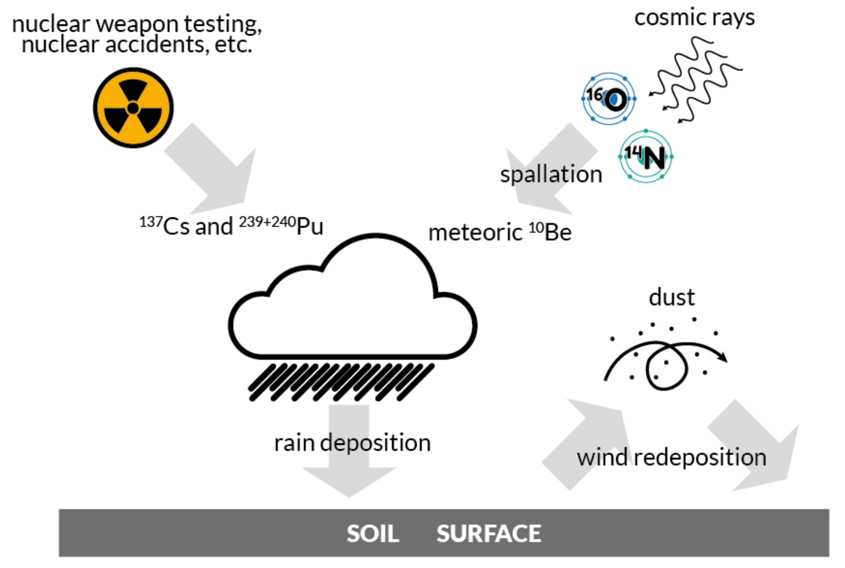
2.1. Formation of Meteoric 10Be
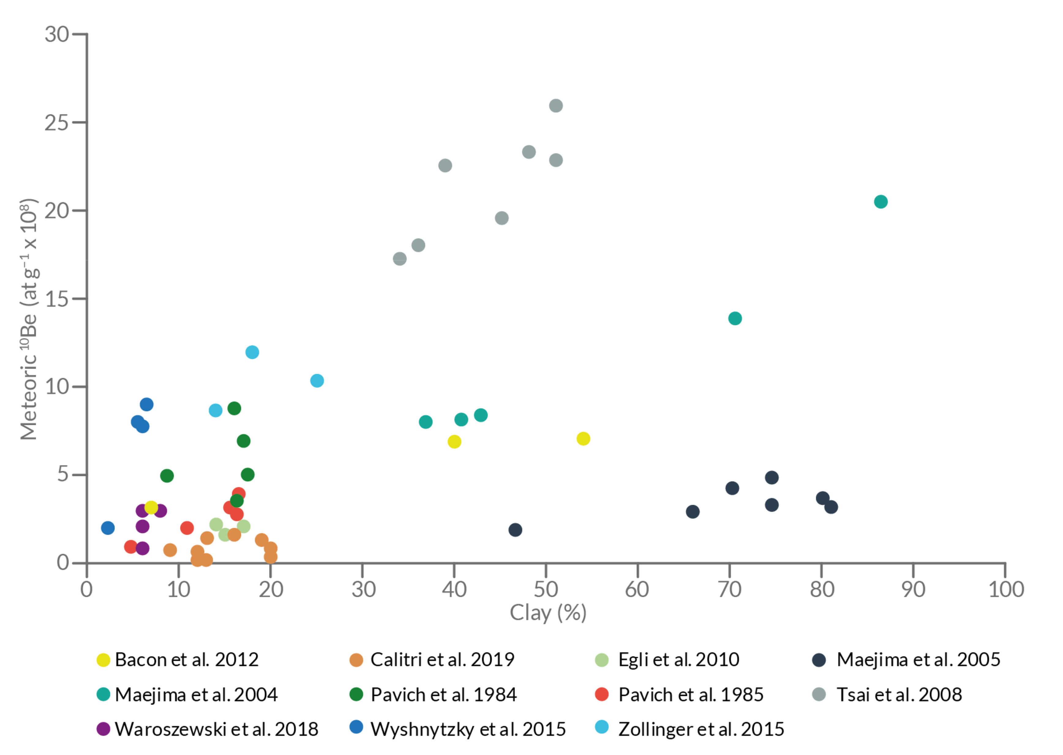
2.2. Meteoric 10Be in Soils
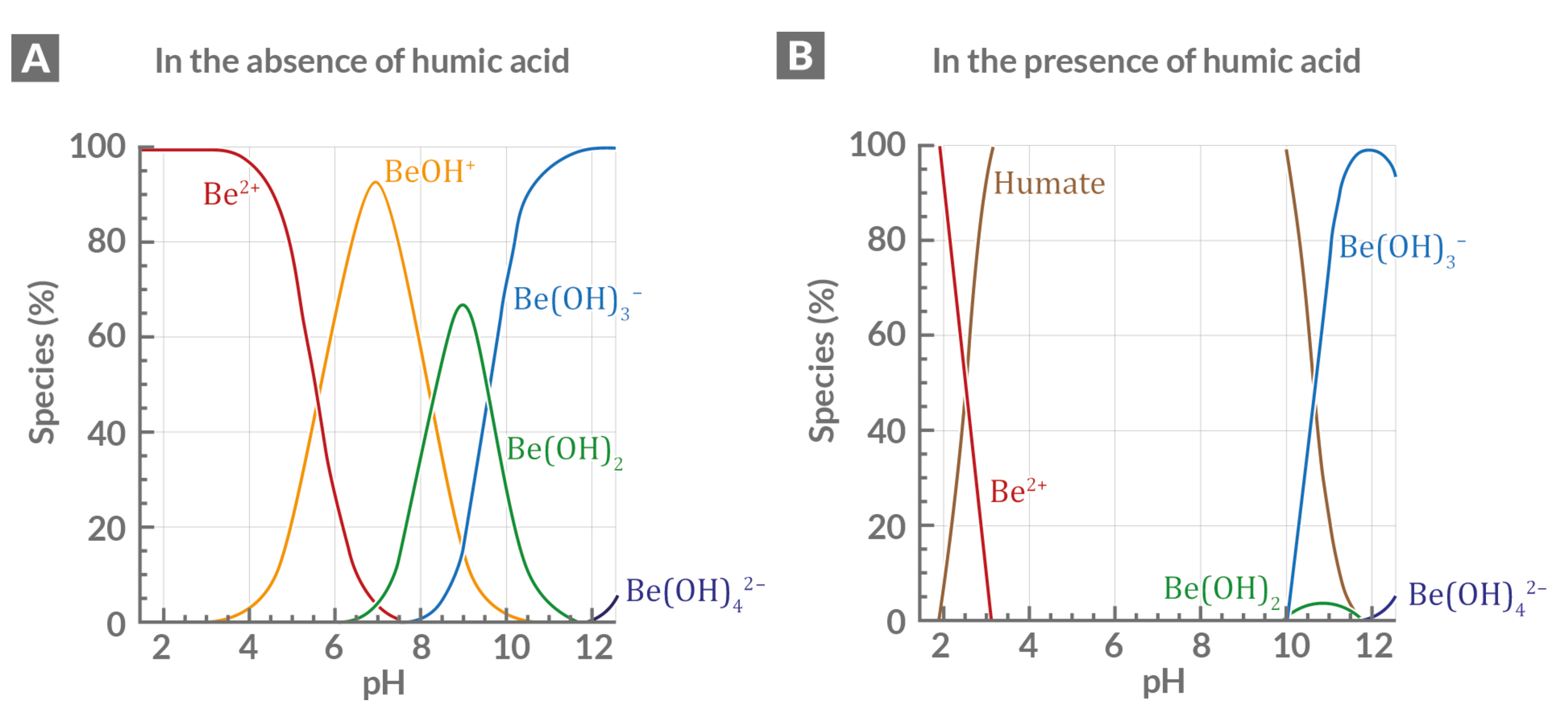
2.3. Origin of Anthropogenic Radionuclides—137Cs and 239+240Pu
2.4. Anthropogenic Nuclides in Soils
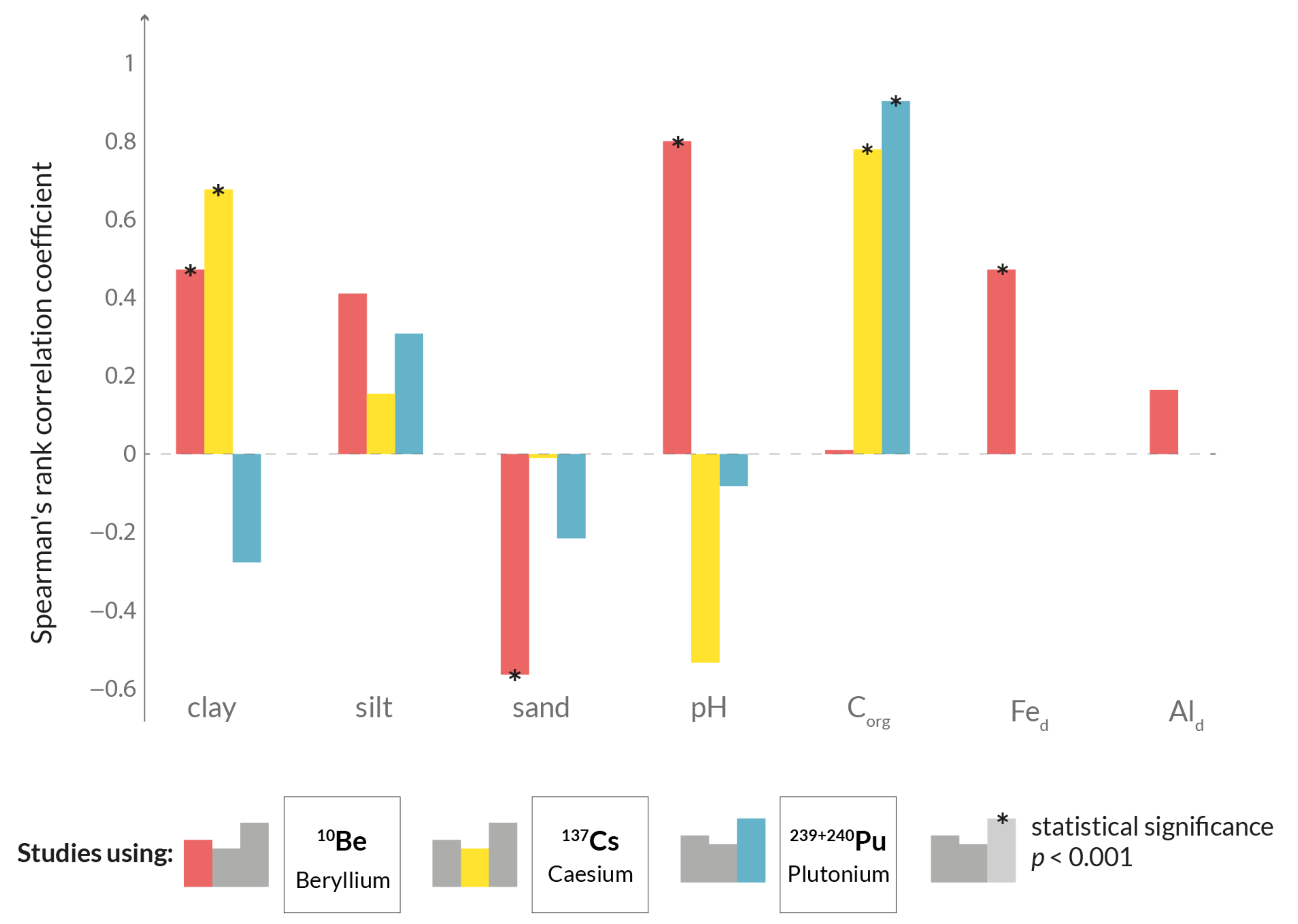
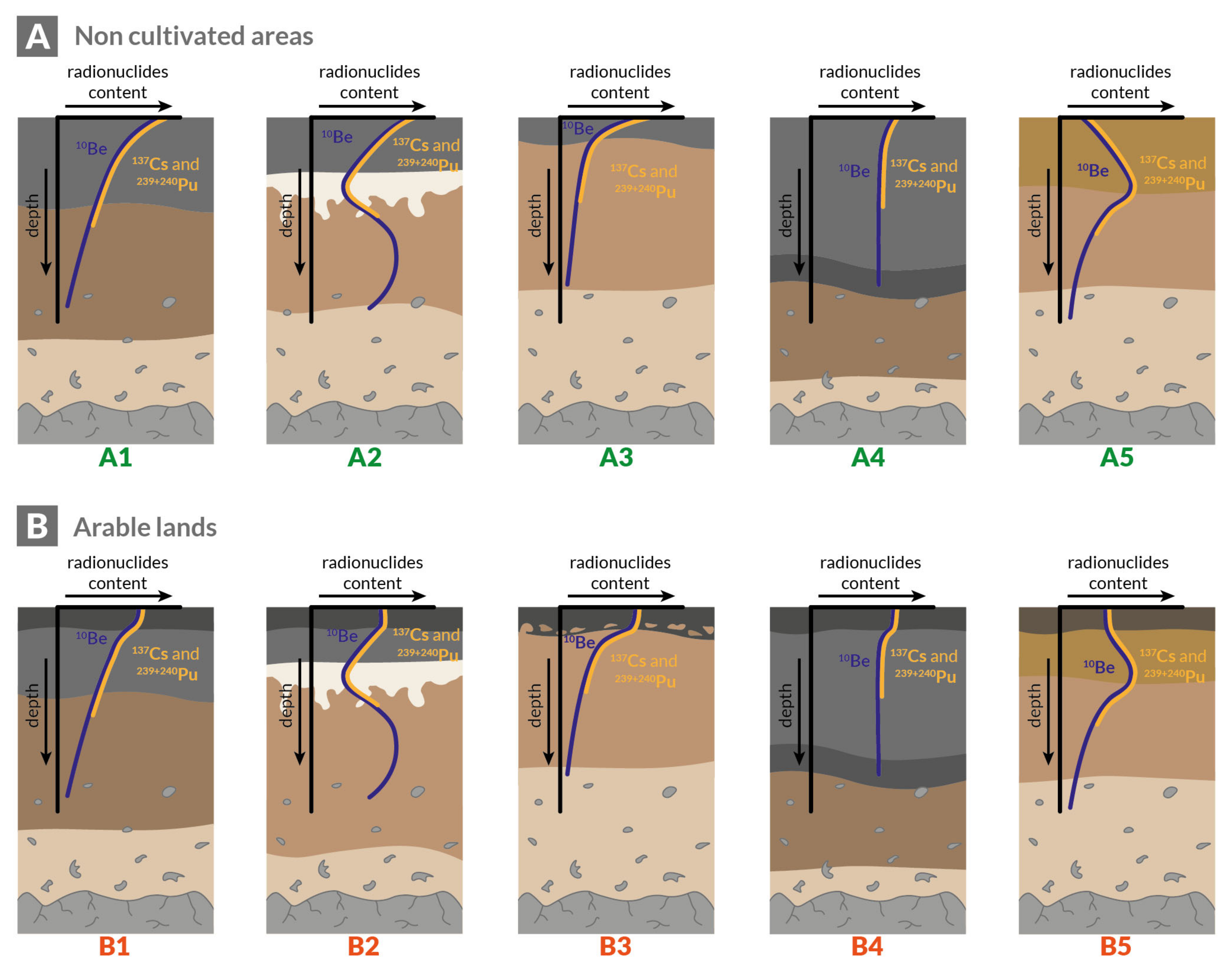
2.5. Profile Depth Distribution of Meteoric 10Be, 137Cs and 239+240Pu
3. Calculation of Soil Erosion Rates Using Meteoric 10Be
4. Reference Sites and Conversion Models for Anthropogenic Radionuclides
4.1. The Importance of Reference Sites
4.2. Soil Redistribution Rates
4.3. Radionuclide Ratios
5. Application in Different Environments in Agricultural and Natural Landscapes
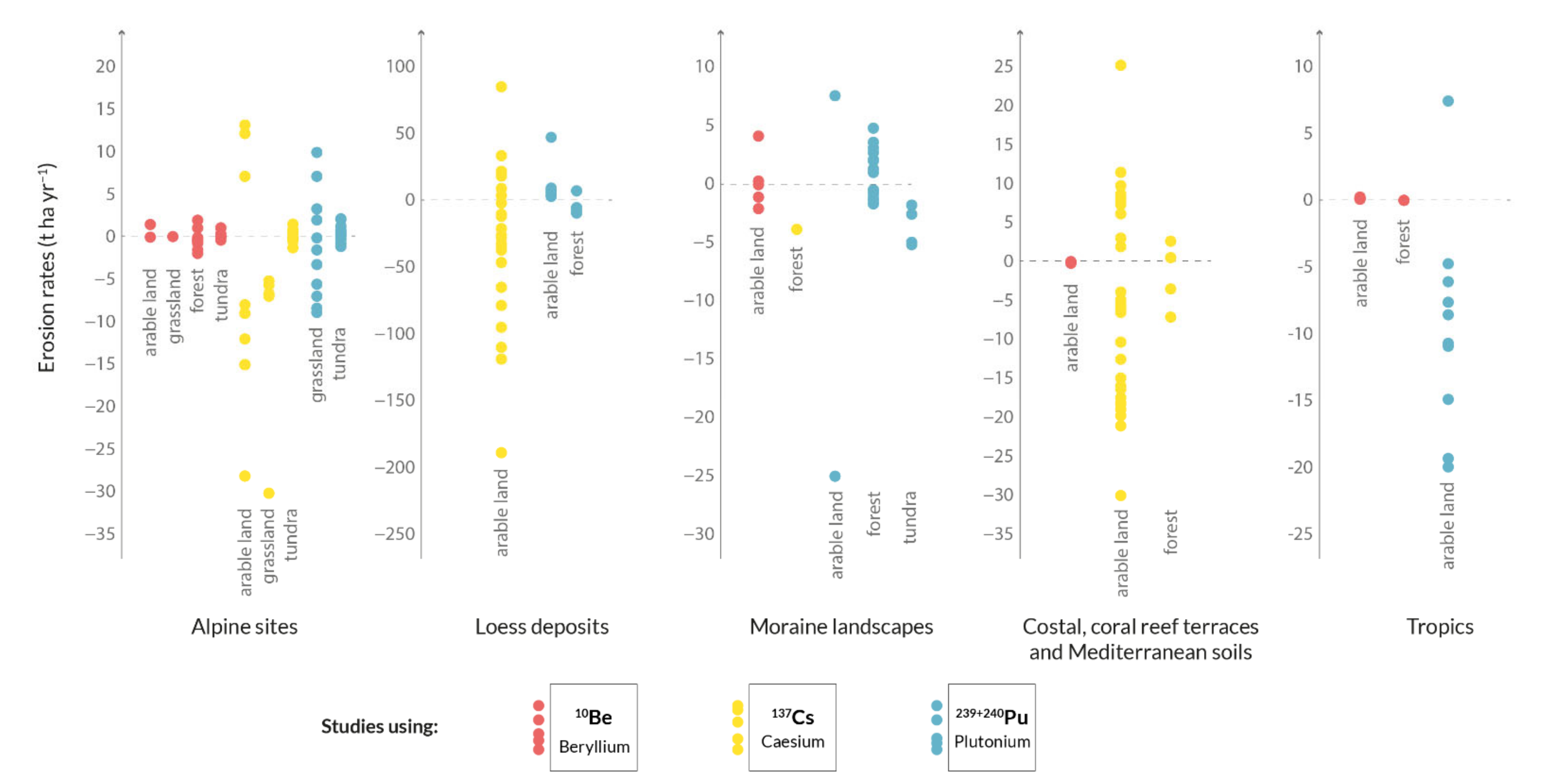
5.1. Alpine Sites
5.2. Loess Deposits
5.3. Moraine Landscapes
5.4. Coastal and Coral Reef Terraces and Mediterranean Soils
5.5. Tropics
5.6. Acidic Soils
6. Conclusions and Outlook
Supplementary Materials
Author Contributions
Funding
Data Availability Statement
Acknowledgments
Conflicts of Interest
References
- Dethier, D.P.; Birkeland, P.W.; McCarthy, J.A. Using the accumulation of CBD-extractable iron and clay content to estimate soil age on stable surfaces and nearby slopes, Front Range, Colorado. Geomorphology 2012, 173–174, 17–29. [Google Scholar] [CrossRef]
- Wyshnytzky, C.E.; Ouimet, W.B.; McCarthy, J.; Dethier, D.P.; Shroba, R.R.; Bierman, P.R.; Rood, D.H. Meteoric 10Be, clay, and extractable iron depth profiles in the Colorado Front Range: Implications for understanding soil mixing and erosion. Catena 2015, 127, 32–45. [Google Scholar] [CrossRef]
- Dixon, J.L.; von Blanckenburg, F. Soils as pacemakers and limiters of global silicate weathering. C. R. Geosci. 2012, 344, 597–609. [Google Scholar] [CrossRef] [Green Version]
- Frank, M.; Schwarz, B.; Baumann, S.; Kubik, P.W.; Suter, M.; Mangini, A. A 200 kyr record of cosmogenic radionuclide production rate and geomagnetic field intensity from 10Be in globally stacked deep-sea sediments1. Earth Planet. Sci. Lett. 1997, 149, 121–129. [Google Scholar] [CrossRef]
- Simon, Q.; Suganuma, Y.; Okada, M.; Haneda, Y. High-resolution 10Be and paleomagnetic recording of the last polarity reversal in the Chiba composite section: Age and dynamics of the Matuyama–Brunhes transition. Earth Planet. Sci. Lett. 2019, 519, 92–100. [Google Scholar] [CrossRef]
- Wagner, G.; Beer, J.; Masarik, J.; Muscheler, R.; Kubik, P.W.; Mende, W.; Laj, C.; Raisbeck, G.M.; Yiou, F. Presence of the Solar de Vries Cycle (~205 years) during the Last Ice Age. Geophys. Res. Lett. 2001, 28, 303–306. [Google Scholar] [CrossRef] [Green Version]
- Wagner, G.; Laj, C.; Beer, J.; Kissel, C.; Muscheler, R.; Masarik, J.; Synal, H.-A. Reconstruction of the paleoaccumulation rate of central Greenland during the last 75 kyr using the cosmogenic radionuclides 36Cl and 10Be and geomagnetic field intensity data. Earth Planet. Sci. Lett. 2001, 193, 515–521. [Google Scholar] [CrossRef]
- Frank, M.; Backman, J.; Jakobsson, M.; Moran, K.; O’Regan, M.; King, J.; Haley, B.A.; Kubik, P.W.; Garbe-Schönberg, D. Beryllium isotopes in central Arctic Ocean sediments over the past 12.3 million years: Stratigraphic and paleoclimatic implications. Paleoceanography 2008, 23, 1–12. [Google Scholar] [CrossRef]
- Dannhaus, N.; Wittmann, H.; Krám, P.; Christl, M.; von Blanckenburg, F. Catchment-wide weathering and erosion rates of mafic, ultramafic, and granitic rock from cosmogenic meteoric 10Be/9Be ratios. Geochim. Cosmochim. Acta 2018, 222, 618–641. [Google Scholar] [CrossRef] [Green Version]
- Maejima, Y.; Matsuzaki, H.; Nakano, C. 10Be concentrations of Red soils in Southwest Japan and its possibility of dating. Nucl. Instrum. Methods Phys. Res. Sect. B Beam Interact. Mater. At. 2004, 223–224, 596–600. [Google Scholar] [CrossRef]
- Maejima, Y.; Matsuzaki, H.; Higashi, T. Application of cosmogenic 10Be to dating soils on the raised coral reef terraces of Kikai Island, southwest Japan. Geoderma 2005, 126, 389–399. [Google Scholar] [CrossRef]
- Tsai, H.; Maejima, Y.; Hseu, Z.Y. Meteoric 10Be dating of highly weathered soils from fluvial terraces in Taiwan. Quat. Int. 2008, 188, 185–196. [Google Scholar] [CrossRef]
- Hao, Y.; Xu, Y.; Pan, S.; Song, X.; Zhang, K.; Guo, H.; Gu, Z. Sources of plutonium isotopes and 137Cs in coastal seawaters of Liaodong Bay and Bohai Strait, China and its environmental implications. Mar. Pollut. Bull. 2018, 130, 240–248. [Google Scholar] [CrossRef]
- Dong, W.; Zheng, J.; Guo, Q. Particle-size speciation of Pu isotopes in surface soils from Inner Mongolia (China) and its implications for Asian Dust monitoring. Appl. Radiat. Isot. 2017, 120, 133–136. [Google Scholar] [CrossRef] [PubMed]
- Egli, M.; Brandová, D.; Böhlert, R.; Favilli, F.; Kubik, P.W. 10Be inventories in Alpine soils and their potential for dating land surfaces. Geomorphology 2010, 119, 62–73. [Google Scholar] [CrossRef] [Green Version]
- Konz, N.; Prasuhn, V.; Alewell, C. On the measurement of alpine soil erosion. Catena 2012, 91, 63–71. [Google Scholar] [CrossRef]
- Alewell, C.; Meusburger, K.; Juretzko, G.; Mabit, L.; Ketterer, M.E. Suitability of 239+240Pu and 137Cs as tracers for soil erosion assessment in mountain grasslands. Chemosphere 2014, 103, 274–280. [Google Scholar] [CrossRef] [Green Version]
- Zollinger, B.; Alewell, C.; Kneisel, C.; Meusburger, K.; Brandová, D.; Kubik, P.; Schaller, M.; Ketterer, M.; Egli, M. The effect of permafrost on time-split soil erosion using radionuclides (137Cs, 239+240Pu, meteoric 10Be) and stable isotopes (δ13C) in the eastern Swiss Alps. J. Soils Sediments 2015, 15, 1400–1419. [Google Scholar] [CrossRef]
- Zollinger, B.; Alewell, C.; Kneisel, C.; Brandová, D.; Petrillo, M.; Plötze, M.; Christl, M.; Egli, M. Soil formation and weathering in a permafrost environment of the Swiss Alps: A multi-parameter and non-steady-state approach. Earth Surf. Process. Landf. 2017, 42, 814–835. [Google Scholar] [CrossRef]
- Meusburger, K.; Porto, P.; Mabit, L.; La Spada, C.; Arata, L.; Alewell, C. Excess Lead-210 and Plutonium-239+240: Two suitable radiogenic soil erosion tracers for mountain grassland sites. Environ. Res. 2018, 160, 195–202. [Google Scholar] [CrossRef]
- Portes, R.; Dahms, D.; Brandová, D.; Raab, G.; Christl, M.; Kühn, P.; Ketterer, M.; Egli, M. Evolution of soil erosion rates in alpine soils of the Central Rocky Mountains using fallout Pu and δ13C. Earth Planet. Sci. Lett. 2018, 496, 257–269. [Google Scholar] [CrossRef] [Green Version]
- Lal, R.; Tims, S.G.; Fifield, L.K.; Wasson, R.J.; Howe, D. Applicability of 239Pu as a tracer for soil erosion in the wet-dry tropics of northern Australia. Nucl. Instruments Methods Phys. Res. Sect. B Beam Interact. Mater. Atoms 2013, 294, 577–583. [Google Scholar] [CrossRef]
- Lal, R.; Fifield, L.K.; Tims, S.G.; Wasson, R.J.; Howe, D. A study of soil erosion rates using 239Pu, in the wet-dry tropics of Northern Australia. J. Environ. Radioact. 2020, 211, 106085. [Google Scholar] [CrossRef] [PubMed]
- Velasco, H.; Astorga, R.T.; Joseph, D.; Antoine, J.S.; Mabit, L.; Toloza, A.; Dercon, G.; Walling, D.E. Adapting the Caesium-137 technique to document soil redistribution rates associated with traditional cultivation practices in Haiti. J. Environ. Radioact. 2018, 183, 7–16. [Google Scholar] [CrossRef]
- Schoonejans, J.; Vanacker, V.; Opfergelt, S.; Christl, M. Long-term soil erosion derived from in-situ 10Be and inventories of meteoric 10Be in deeply weathered soils in southern Brazil. Chem. Geol. 2017, 466, 380–388. [Google Scholar] [CrossRef]
- Wilken, F.; Fiener, P.; Ketterer, M.; Meusburger, K.; Muhindo, D.I.; van Oost, K.; Doetterl, S. Assessing soil redistribution of forest and cropland sites in wet tropical Africa using 239+240 Pu fallout radionuclides. Soil 2021, 7, 399–414. [Google Scholar] [CrossRef]
- Waroszewski, J.; Egli, M.; Brandová, D.; Christl, M.; Kabala, C.; Malkiewicz, M.; Kierczak, J.; Glina, B.; Jezierski, P. Identifying slope processes over time and their imprint in soils of medium-high mountains of Central Europe (the Karkonosze Mountains, Poland). Earth Surf. Process. Landf. 2018, 43, 1195–1212. [Google Scholar] [CrossRef] [Green Version]
- Mabit, L.; Bernard, C.; Laverdière, M.R. Assessment of erosion in the Boyer River watershed (Canada) using a GIS oriented sampling strategy and 137Cs measurements. Catena 2007, 71, 242–249. [Google Scholar] [CrossRef]
- Mabit, L.; Chhem-Kieth, S.; Toloza, A.; Vanwalleghem, T.; Bernard, C.; Amate, J.I.; González de Molina, M.; Gómez, J.A. Radioisotopic and physicochemical background indicators to assess soil degradation affecting olive orchards in southern Spain. Agric. Ecosyst. Environ. 2012, 159, 70–80. [Google Scholar] [CrossRef]
- Meliho, M.; Nouira, A.; Benmansour, M.; Boulmane, M.; Khattabi, A.; Mhammdi, N.; Benkdad, A. Assessment of soil erosion rates in a Mediterranean cultivated and uncultivated soils using fallout 137Cs. J. Environ. Radioact. 2019, 208–209, 106021. [Google Scholar] [CrossRef]
- Quijano, L.; Beguería, S.; Gaspar, L.; Navas, A. Estimating erosion rates using 137Cs measurements and WATEM/SEDEM in a Mediterranean cultivated field. Catena 2016, 138, 38–51. [Google Scholar] [CrossRef]
- Jelinski, N.A.; Campforts, B.; Willenbring, J.K.; Schumacher, T.E.; Li, S.; Lobb, D.A.; Papiernik, S.K.; Yoo, K. Meteoric Beryllium-10 as a Tracer of Erosion Due to Postsettlement Land Use in West-Central Minnesota, USA. J. Geophys. Res. Earth Surf. 2019, 124, 874–901. [Google Scholar] [CrossRef]
- Calitri, F.; Sommer, M.; Norton, K.; Temme, A.; Brandová, D.; Portes, R.; Christl, M.; Ketterer, M.E.; Egli, M. Tracing the temporal evolution of soil redistribution rates in an agricultural landscape using 239+240Pu and 10Be. Earth Surf. Process. Landf. 2019, 44, 1783–1789. [Google Scholar] [CrossRef]
- Calitri, F.; Sommer, M.; van der Meij, M.W.; Egli, M. Soil erosion along a transect in a forested catchment: Recent or ancient processes? Catena 2020, 194, 104683. [Google Scholar] [CrossRef]
- Ouimet, W.; Dethier, D.; Bierman, P.; Wyshnytzky, C.; Shea, N.; Rood, D.H. Spatial and temporal variations in meteoric 10Be inventories and long-term deposition rates, Colorado Front Range. Quat. Sci. Rev. 2015, 109, 1–12. [Google Scholar] [CrossRef]
- Tuo, D.; Xu, M.; Gao, G. Relative contributions of wind and water erosion to total soil loss and its effect on soil properties in sloping croplands of the Chinese Loess Plateau. Sci. Total Environ. 2018, 633, 1032–1040. [Google Scholar] [CrossRef]
- Jagercikova, M.; Cornu, S.; Bourlès, D.; Antoine, P.; Mayor, M.; Guillou, V. Understanding long-term soil processes using meteoric 10Be: A first attempt on loessic deposits. Quat. Geochronol. 2015, 27, 11–21. [Google Scholar] [CrossRef]
- Poręba, G.J.; Śnieszko, Z.; Moska, P. Application of OSL dating and 137Cs measurements to reconstruct the history of water erosion: A case study of a Holocene colluvium in Świerklany, south Poland. Quat. Int. 2015, 374, 189–197. [Google Scholar] [CrossRef]
- Zhang, X.; Quine, T.A.; Walling, D.E. Soil erosion rates on sloping cultivated land on the Loess Plateau near Ansai, Shaanxi Province, China: An investigation using 137Cs and rill measurements. Hydrol. Process. 1998, 12, 171–189. [Google Scholar] [CrossRef]
- Loba, A.; Waroszewski, J.; Tikhomirov, D.; Calitri, F.; Christl, M.; Sykuła, M.; Egli, M. Tracing erosion rates in loess landscape of the Trzebnica Hills (Poland) over time using fallout and cosmogenic nuclides. J. Soils Sediments 2021, 21, 2952–2968. [Google Scholar] [CrossRef]
- Kaste, J.M.; Elmore, A.J.; Vest, K.R.; Okin, G.S. Groundwater controls on episodic soil erosion and dust emissions in a desert ecosystem. Geology 2016, 44, 771–774. [Google Scholar] [CrossRef]
- Abrahams, E.R.; Kaste, J.M.; Ouimet, W.; Dethier, D.P. Asymmetric hillslope erosion following wildfire in Fourmile Canyon, Colorado. Earth Surf. Process. Landf. 2018, 43, 2009–2021. [Google Scholar] [CrossRef] [Green Version]
- McKean, J.A.; Dietrich, W.E.; Finkel, R.C.; Southon, J.R.; Caffee, M.W. Quantification of soil production and downslope creep rates from cosmogenic 10Be accumulations on a hillslope profile. Geology 1993, 21, 343–346. [Google Scholar] [CrossRef]
- Small, E.E.; Anderson, R.S.; Hancock, G.S. Estimates of the rate of regolith production using 10Be and 26Al from an alpine hillslope. Geomorphology 1999, 27, 131–150. [Google Scholar] [CrossRef]
- Jungers, M.C.; Bierman, P.R.; Matmon, A.; Nichols, K.; Larsen, J.; Finkel, R. Tracing hillslope sediment production and transport with in situ and meteoric 10Be. J. Geophys. Res. Earth Surf. 2009, 114, 1–16. [Google Scholar] [CrossRef]
- West, N.; Kirby, E.; Bierman, P.; Slingerland, R.; Ma, L.; Rood, D.; Brantley, S. Regolith production and transport at the Susquehanna Shale Hills Critical Zone Observatory, Part 2: Insights from meteoric 10Be. J. Geophys. Res. Earth Surf. 2013, 118, 1877–1896. [Google Scholar] [CrossRef] [Green Version]
- West, N.; Kirby, E.; Bierman, P.; Clarke, B.A. Aspect-dependent variations in regolith creep revealed by meteoric 10Be. Geology 2014, 42, 507–510. [Google Scholar] [CrossRef]
- Graly, J.A.; Bierman, P.R.; Reusser, L.J.; Pavich, M.J. Meteoric 10Be in soil profiles—A global meta-analysis. Geochim. Cosmochim. Acta 2010, 74, 6814–6829. [Google Scholar] [CrossRef]
- Alewell, C.; Pitois, A.; Meusburger, K.; Ketterer, M.; Mabit, L. 239+240Pu from “contaminant” to soil erosion tracer: Where do we stand? Earth-Sci. Rev. 2017, 172, 107–123. [Google Scholar] [CrossRef]
- McHargue, L.R.; Damon, P.E. The global beryllium 10 cycle. Rev. Geophys. 1991, 29, 141. [Google Scholar] [CrossRef]
- Monaghan, M.C.; Krishnaswami, S.; Turekian, K.K. The global-average production rate of 10Be. Earth Planet. Sci. Lett. 1986, 76, 279–287. [Google Scholar] [CrossRef]
- Willenbring, J.K.; von Blanckenburg, F. Meteoric cosmogenic Beryllium-10 adsorbed to river sediment and soil: Applications for Earth-surface dynamics. Earth-Sci. Rev. 2010, 98, 105–122. [Google Scholar] [CrossRef] [Green Version]
- Beer, J.; McCracken, K.; von Steiger, R. Cosmogenic Radionuclides. Theory and Applications in the Terrestial and Space Environments; Physics of Earth and Space Environments; Springer: Berlin/Heidelberg, Germany, 2012; Volume 53, ISBN 978-3-642-14650-3. [Google Scholar]
- Kaste, J.M.; Baskaran, M. Meteoric 7Be and 10Be as Process Tracers in the Environment. In Handbook of Environmental Isotope Geochemistry; Baskaran, M., Ed.; Advances in Isotope Geochemistry; Springer: Berlin/Heidelberg, Germany, 2012; Volume 1, pp. 61–85. ISBN 978-3-642-10636-1. [Google Scholar]
- Graly, J.A.; Reusser, L.J.; Bierman, P.R. Short and long-term delivery rates of meteoric10Be to terrestrial soils. Earth Planet. Sci. Lett. 2011, 302, 329–336. [Google Scholar] [CrossRef]
- Kaste, J.M.; Norton, S.A.; Hess, C.T. Environmental Chemistry of Beryllium-7. Rev. Mineral. Geochemistry 2002, 50, 271–289. [Google Scholar] [CrossRef]
- Pavich, M.J.; Brown, L.; Valette-Silver, J.N.; Klein, J.; Middleton, R. 10Be analysis of a Quaternary weathering profile in the Virginia Piedmont. Geology 1985, 13, 39. [Google Scholar] [CrossRef]
- Boschi, V.; Willenbring, J.K. Chemical and physical drivers of beryllium retention in two soil endmembers. Sci. Total Environ. 2021, 754, 141591. [Google Scholar] [CrossRef] [PubMed]
- You, C.-F.; Lee, T.; Li, Y.-H. The partition of Be between soil and water. Chem. Geol. 1989, 77, 105–118. [Google Scholar] [CrossRef]
- Pavich, M.J.; Brown, L.; Harden, J.; Klein, J.; Middleton, R. 10Be distribution in soils from Merced River terraces, California. Geochim. Cosmochim. Acta 1986, 50, 1727–1735. [Google Scholar] [CrossRef]
- Vesely, J.; Norton, S.A.; Skrivan, P.; Majer, V.; Kram, P.; Navratil, T.; Kaste, J.M. Environmental Chemistry of Beryllium. Rev. Mineral. Geochemistry 2002, 50, 291–317. [Google Scholar] [CrossRef]
- Bacon, A.R.; Richter, D.D.B.; Bierman, P.R.; Rood, D.H. Coupling meteoric 10Be with pedogenic losses of 9Be to improve soil residence time estimates on an ancient North American interfluve. Geology 2012, 40, 847–850. [Google Scholar] [CrossRef]
- Pavich, M.J.; Brown, L.; Klein, J.; Middleton, R. 10Be accumulation in a soil chronosequence. Earth Planet. Sci. Lett. 1984, 68, 198–204. [Google Scholar] [CrossRef]
- Takahashi, Y.; Minai, Y.; Ambe, S.; Makide, Y.; Ambe, F. Comparison of adsorption behavior of multiple inorganic ions on kaolinite and silica in the presence of humic acid using the multitracer technique. Geochim. Cosmochim. Acta 1999, 63, 815–836. [Google Scholar] [CrossRef]
- Ritchie, J.C.; McHenry, J.R. Application of Radioactive Fallout Cesium-137 for Measuring Soil Erosion and Sediment Accumulation Rates and Patterns: A Review. J. Environ. Qual. 1990, 19, 215–233. [Google Scholar] [CrossRef] [Green Version]
- Xu, Y.; Qiao, J.; Pan, S.; Hou, X.; Roos, P.; Cao, L. Plutonium as a tracer for soil erosion assessment in northeast China. Sci. Total Environ. 2015, 511, 176–185. [Google Scholar] [CrossRef]
- Nelson, D.M.; Lovett, M.B. Oxidation state of plutonium in the Irish Sea. Nature 1978, 276, 599–601. [Google Scholar] [CrossRef]
- Penrose, W.R.; Metta, D.N.; Hylko, J.M.; Rinckel, L.A. The reduction of plutonium(V) by aquatic sediments. J. Environ. Radioact. 1987, 5, 169–184. [Google Scholar] [CrossRef]
- Choppin, G.R. Actinide speciation in aquatic systems. Mar. Chem. 2006, 99, 83–92. [Google Scholar] [CrossRef]
- Eakins, J.D.; Morgan, A.; Baston, G.M.N.; Pratley, F.W.; Strange, L.P.; Burton, P.J. Measurements of α-emitting plutonium and americium in the intertidal sands of West Cumbria, UK. J. Environ. Radioact. 1990, 11, 37–54. [Google Scholar] [CrossRef]
- Iurian, A.-R.; Phaneuf, M.O.; Mabit, L. Mobility and Bioavailability of Radionuclides in Soils. In Radionuclides in the Environment. Influence of Chemical Speciation and Plant Uptake on Radionuclide Migration; Springer: Cham, Switzerland, 2015; pp. 38–59. [Google Scholar]
- Kim, C.S.; Lee, M.H.; Kim, C.K.; Kim, K.H. 90Sr, 137Cs, 239+240Pu and 238Pu concentrations in surface soils of Korea. J. Environ. Radioact. 1998, 40, 75–88. [Google Scholar] [CrossRef]
- Chibowski, S.; Zygmunt, J. The influence of the sorptive properties of organic soils on the migration rate of 137Cs. J. Environ. Radioact. 2002, 61, 213–223. [Google Scholar] [CrossRef]
- Giannakopoulou, F.; Haidouti, C.; Chronopoulou, A.; Gasparatos, D. Sorption behavior of cesium on various soils under different pH levels. J. Hazard. Mater. 2007, 149, 553–556. [Google Scholar] [CrossRef] [PubMed]
- Livens, F.R.; Loveland, P.J. The influence of soil properties on the environmental mobility of caesium in Cumbria. Soil Use Manag. 1988, 4, 69–75. [Google Scholar] [CrossRef]
- Kabata-Pendias, A.; Mukherjee, A.B. (Eds.) Trace Elements of Group 1 (Previously Group Ia) BT—Trace Elements from Soil to Human; Springer: Berlin/Heidelberg, Germany, 2007; pp. 87–104. ISBN 978-3-540-32714-1. [Google Scholar]
- Tamura, T.; Jacobs, D.G. Structural implications in cesium sorption. Health Phys. 1960, 2, 391—398. [Google Scholar] [CrossRef] [PubMed]
- Bertsch, P.M. Cesium-137 in floodplain sediments of the Lower Three Runs Creek on the DOE Savannah River Site. J. Radioanal. Nucl. Chem. 2005, 264, 481–488. [Google Scholar] [CrossRef]
- García-Oliva, F.; Lugo, R.M.; Maass, J.M. Soil 137Cs activity in a tropical deciduous ecosystem under pasture conversion in Mexico. J. Environ. Radioact. 1995, 26, 37–49. [Google Scholar] [CrossRef]
- Van Bergeijk, K.E.; Noordijk, H.; Lembrechts, J.; Frissel, M.J. Influence of pH, soil type and soil organic matter content on soil-to-plant transfer of radiocesium and -strontium as analyzed by a nonparametric method. J. Environ. Radioact. 1992, 15, 265–276. [Google Scholar] [CrossRef]
- Matisoff, G.; Whiting, P.J. Measuring Soil Erosion Rates Using Natural (7Be, 210Pb) and Anthropogenic (137Cs, 239,240Pu) Radionuclides. In Handbook of Environmental Isotope Geochemistry; Springer: Berlin/Heidelberg, Germany, 2012; Volume 1–2, pp. 487–519. ISBN 9783642106378. [Google Scholar]
- Sanchez, A.L.; Wright, S.M.; Smolders, E.; Naylor, C.; Stevens, P.A.; Kennedy, V.H.; Dodd, B.A.; Singleton, D.L.; Barnett, C.L. High Plant Uptake of Radiocesium from Organic Soils Due to Cs Mobility and Low Soil K Content. Environ. Sci. Technol. 1999, 33, 2752–2757. [Google Scholar] [CrossRef]
- Sheppard, S.C. Robust Prediction of Kd from Soil Properties for Environmental Assessment. Hum. Ecol. Risk Assess. Int. J. 2011, 17, 263–279. [Google Scholar] [CrossRef]
- Wissocq, A.; Beaucaire, C.; Latrille, C. Application of the multi-site ion exchanger model to the sorption of Sr and Cs on natural clayey sandstone. Appl. Geochem. 2018, 93, 167–177. [Google Scholar] [CrossRef] [Green Version]
- Siroux, B.; Beaucaire, C.; Tabarant, M.; Benedetti, M.F.; Reiller, P.E.; Wissocq, A.; Beaucaire, C.; Latrille, C. Adsorption of strontium and caesium onto an Na-MX80 bentonite: Experiments and building of a coherent thermodynamic modelling. Appl. Geochem. 2018, 93, 167–175. [Google Scholar] [CrossRef]
- Nishiizumi, K.; Imamura, M.; Caffee, M.W.; Southon, J.R.; Finkel, R.C.; McAninch, J. Absolute calibration of 10Be AMS standards. Nucl. Instrum. Methods Phys. Res. Sect. B Beam Interact. Mater. At. 2007, 258, 403–413. [Google Scholar] [CrossRef]
- Harden, J.W.; Fries, T.L.; Pavich, M.J. Cycling of beryllium and carbon through hillslope soils in Iowa. Biogeochemistry 2002, 60, 317–336. [Google Scholar] [CrossRef]
- Knudsen, M.F.; Egholm, D.L.; Jansen, J.D. Time-integrating cosmogenic nuclide inventories under the influence of variable erosion, exposure, and sediment mixing. Quat. Geochronol. 2019, 51, 110–119. [Google Scholar] [CrossRef]
- Meusburger, K.; Mabit, L.; Ketterer, M.; Park, J.H.; Sandor, T.; Porto, P.; Alewell, C. A multi-radionuclide approach to evaluate the suitability of 239+240Pu as soil erosion tracer. Sci. Total Environ. 2016, 566–567, 1489–1499. [Google Scholar] [CrossRef] [Green Version]
- Mabit, L.; Martin, P.; Jankong, P.; Toloza, A.; Padilla-Alvarez, R.; Zupanc, V. Establishment of control site baseline data for erosion studies using radionuclides: A case study in East Slovenia. J. Environ. Radioact. 2010, 101, 854–863. [Google Scholar] [CrossRef]
- Lal, D. New Nuclear Methods for Studies of Soil Dynamics Utilizing Cosmic Ray Produced Radionuclides. In Sustaining the Global Farm-10th International Soil Conservation Organization Meeting; Stott, D.E., Mohtar, R.H., Steinhardt, G.C., Eds.; Purdue University: West Lafayette, IN, USA; USDA-ARS National Soil Erosion Research Laboratory: Washington, DC, USA, 2001; pp. 1044–1052. [Google Scholar]
- Campforts, B.; Vanacker, V.; Vanderborght, J.; Baken, S.; Smolders, E.; Govers, G. Simulating the mobility of meteoric 10Be in the landscape through a coupled soil-hillslope model (Be2D). Earth Planet. Sci. Lett. 2016, 439, 143–157. [Google Scholar] [CrossRef]
- Owens, P.N.; Walling, D.E. Spatial variability of caesium-137 inventories at reference sites: An example from two contrasting sites in England and Zimbabwe. Appl. Radiat. Isot. 1996, 47, 699–707. [Google Scholar] [CrossRef]
- Sutherland, R.A. Examination of caesium-137 areal activities in control (uneroded) locations. Soil Technol. 1991, 4, 33–50. [Google Scholar] [CrossRef]
- Poręba, G.; Śnieszko, Z.; Moska, P.; Mroczek, P.; Malik, I. Interpretation of soil erosion in a Polish loess area using OSL, 137Cs, 210Pbex, dendrochronology and micromorphology—Case study: Biedrzykowice site (s Poland). Geochronometria 2019, 46, 57–78. [Google Scholar] [CrossRef] [Green Version]
- Sarmiento, J.L.; Gwinn, E. Strontium 90 fallout prediction. J. Geophys. Res. 1986, 91, 7631. [Google Scholar] [CrossRef]
- Poreba, G.J. Caesium-137 as a soil erosion tracer: A review. Geochronometria 2006, 25, 37–46. [Google Scholar]
- Walling, D.E.; Quine, T.A. Calibration of caesium-137 measurements to provide quantitative erosion rate data. Land Degrad. Dev. 1990, 2, 161–175. [Google Scholar] [CrossRef]
- Kachanoski, R.G.; de Jong, E. Predicting the Temporal Relationship between Soil Cesium-137 and Erosion Rate. J. Environ. Qual. 1984, 13, 301–304. [Google Scholar] [CrossRef]
- Zhang, X.; Higgit, D.L.; Walling, D.E. A preliminary assessment of the potential for using caesium-137 to estimate rates of soil erosion in the Loess Plateau of China. Hydrol. Sci. J. 1990, 35, 243–252. [Google Scholar] [CrossRef] [Green Version]
- Walling, D.E.; He, Q. Improved Models for Estimating Soil Erosion Rates from Cesium-137 Measurements. J. Environ. Qual. 1999, 28, 611–622. [Google Scholar] [CrossRef]
- He, Q.; Walling, D.E. The distribution of fallout 137Cs and 210Pb in undisturbed and cultivated soils. Appl. Radiat. Isot. 1997, 48, 677–690. [Google Scholar] [CrossRef]
- Owens, P.N.; Walling, D.E. The use of a numerical mass-balance model to estimate rates of soil redistribution on uncultivated land from 137Cs measurements. J. Environ. Radioact. 1998, 40, 185–203. [Google Scholar] [CrossRef]
- Van Oost, K.; Govers, G.; Van Muysen, W. A process-based conversion model for caesium-137 derived erosion rates on agricultural land: An integrated spatial approach. Earth Surf. Process. Landf. 2003, 28, 187–207. [Google Scholar] [CrossRef]
- Mietelski, J.W.; Was, B. Plutonium from Chernobyl in Poland. Appl. Radiat. Isot. 1995, 46, 1203–1211. [Google Scholar] [CrossRef]
- Ketterer, M.E.; Zheng, J.; Yamada, M. Applications of Transuranics as Tracers and Chronometers in the Environment. In Handbook of Environmental Isotope Geochemistry; Springer: Berlin/Heidelberg, Germany, 2012; Volume 1–2, pp. 395–417. ISBN 9783642106378. [Google Scholar]
- Zheng, J.; Tagami, K.; Watanabe, Y.; Uchida, S.; Aono, T.; Ishii, N.; Yoshida, S.; Kubota, Y.; Fuma, S.; Ihara, S. Isotopic evidence of plutonium release into the environment from the Fukushima DNPP accident. Sci. Rep. 2012, 2, 304. [Google Scholar] [CrossRef] [Green Version]
- Kelley, J.M.; Bond, L.A.; Beasley, T.M. Global distribution of Pu isotopes and 237Np. Sci. Total Environ. 1999, 237–238, 483–500. [Google Scholar] [CrossRef]
- Ketterer, M.E.; Hafer, K.M.; Link, C.L.; Kolwaite, D.; Wilson, J.; Mietelski, J.W. Resolving global versus local/regional Pu sources in the environment using sector ICP-MS. J. Anal. At. Spectrom. 2004, 19, 241–245. [Google Scholar] [CrossRef]
- Mabit, L.; Benmansour, M.; Walling, D.E. Comparative advantages and limitations of the fallout radionuclides 137Cs, 210Pbex and 7Be for assessing soil erosion and sedimentation. J. Environ. Radioact. 2008, 99, 1799–1807. [Google Scholar] [CrossRef] [PubMed]
- Mabit, L.; Dercon, G.; Benmansour, M.; Walling, D.E. Use of 137Cs,210Pbex and 7Be for documenting soil redistribution: The future. In Guidelines for Using Fallout Radionuclides to Assess Erosion and Effectiveness of Soil Conservation Strategies; IAEA-TECDOC-1741; IAEA: Vienna, Austria, 2014; pp. 203–208. ISBN 978–92–0–105414–2. [Google Scholar]
- Pennock, D.J.; Lemmen, D.S.; De Jong, E. Cesium-137-measured erosion rates for soils of five parent-material groups in southwestern Saskatchewan. Can. J. Soil Sci. 1995, 75, 205–210. [Google Scholar] [CrossRef]
- Monaghan, M.C.; Krishnaswami, S.; Thomas, J.H. 10Be concentrations and the long-term fate of particle-reactive nuclides in five soil profiles from California. Earth Planet. Sci. Lett. 1983, 65, 51–60. [Google Scholar] [CrossRef]
- Van Pelt, R.S.; Zobeck, T.M.; Ritchie, J.C.; Gill, T.E. Validating the use of 137Cs measurements to estimate rates of soil redistribution by wind. Catena 2007, 70, 455–464. [Google Scholar] [CrossRef]
- Schuller, P.; Walling, D.; Sepúlveda, A.; Trumper, R.; Rouanet, J.; Pino, I.; Castillo, A. Use of 137Cs measurements to estimate changes in soil erosion rates associated with changes in soil management practices on cultivated land. Appl. Radiat. Isot. 2004, 60, 759–766. [Google Scholar] [CrossRef]
- Evans, R.; Collins, A.L.; Zhang, Y.; Foster, I.D.L.; Boardman, J.; Sint, H.; Lee, M.R.F.; Griffith, B.A. A comparison of conventional and 137Cs-based estimates of soil erosion rates on arable and grassland across lowland England and Wales. Earth-Sci. Rev. 2017, 173, 49–64. [Google Scholar] [CrossRef]
- Quijano, L.; Gaspar, L.; Navas, A. Spatial patterns of SOC, SON, 137Cs and soil properties as affected by redistribution processes in a Mediterranean cultivated field (Central Ebro Basin). Soil Tillage Res. 2016, 155, 318–328. [Google Scholar] [CrossRef] [Green Version]
- Benmansour, M.; Mabit, L.; Nouira, A.; Moussadek, R.; Bouksirate, H.; Duchemin, M.; Benkdad, A. Assessment of soil erosion and deposition rates in a Moroccan agricultural field using fallout 137Cs and 210Pbex. J. Environ. Radioact. 2013, 115, 97–106. [Google Scholar] [CrossRef]
- Porto, P.; Callegari, G. Using 137Cs measurements to estimate soil erosion rates in forest stands affected by wildfires. Results from plot experiments. Appl. Radiat. Isot. 2021, 172, 109668. [Google Scholar] [CrossRef]
- Saç, M.M.; İçhedef, M. Application of 137Cs technique for evaluation of erosion and deposition rates within cultivated fields of Salihli region, Western Turkey. J. Radiat. Res. Appl. Sci. 2015, 8, 477–482. [Google Scholar] [CrossRef] [Green Version]
- Zhang, W.; Xing, S.; Hou, X. Evaluation of soil erosion and ecological rehabilitation in Loess Plateau region in Northwest China using plutonium isotopes. Soil Tillage Res. 2019, 191, 162–170. [Google Scholar] [CrossRef]
- Zhang, K.; Pan, S.; Liu, Z.; Li, G.; Xu, Y.; Hao, Y. Vertical distributions and source identification of the radionuclides 239Pu and 240Pu in the sediments of the Liao River estuary, China. J. Environ. Radioact. 2018, 181, 78–84. [Google Scholar] [CrossRef]
- Li, M.; Li, Z.; Liu, P.; Yao, W. Using Cesium-137 technique to study the characteristics of different aspect of soil erosion in the Wind-water Erosion Crisscross Region on Loess Plateau of China. Appl. Radiat. Isot. 2005, 62, 109–113. [Google Scholar] [CrossRef] [PubMed]
- Gharibreza, M.; Zaman, M.; Porto, P.; Fulajtar, E.; Parsaei, L.; Eisaei, H. Assessment of deforestation impact on soil erosion in loess formation using 137Cs method (case study: Golestan Province, Iran). Int. Soil Water Conserv. Res. 2020, 8, 393–405. [Google Scholar] [CrossRef]
- Hua-juni, F.; Xue-ming, Y.; Xiao-ping, Z.; Ai-zhenl, L. Using 137Cs Tracer Technique to Evaluate Erosion and Deposition of Black Soil in Northeast China. Pedosphere 2006, 16, 201–209. [Google Scholar]
- Yang, M.-Y.; Tian, J.-L.; Liu, P.-L. Investigating the spatial distribution of soil erosion and deposition in a small catchment on the Loess Plateau of China, using 137Cs. Soil Tillage Res. 2006, 87, 186–193. [Google Scholar] [CrossRef]
- Fifield, L.K.; Wasson, R.J.; Pillans, B.; Stone, J.O.H. The longevity of hillslope soil in SE and NW Australia. Catena 2010, 81, 32–42. [Google Scholar] [CrossRef]
- Hoo, W.T.; Fifield, L.K.; Tims, S.G.; Fujioka, T.; Mueller, N. Using fallout plutonium as a probe for erosion assessment. J. Environ. Radioact. 2011, 102, 937–942. [Google Scholar] [CrossRef]
- Arata, L.; Alewell, C.; Frenkel, E.; A’Campo-Neuen, A.; Iurian, A.R.; Ketterer, M.E.; Mabit, L.; Meusburger, K. Modelling Deposition and Erosion rates with RadioNuclides (MODERN)—Part 2: A comparison of different models to convert 239+240Pu inventories into soil redistribution rates at unploughed sites. J. Environ. Radioact. 2016, 162–163, 97–106. [Google Scholar] [CrossRef] [PubMed] [Green Version]
- Musso, A.; Ketterer, M.E.; Greinwald, K.; Geitner, C.; Egli, M. Rapid decrease of soil erosion rates with soil formation and vegetation development in periglacial areas. Earth Surf. Process. Landf. 2020, 45, 2824–2839. [Google Scholar] [CrossRef]
- Schmidt, S.; Alewell, C.; Meusburger, K. Monthly RUSLE soil erosion risk of Swiss grasslands. J. Maps 2019, 15, 247–256. [Google Scholar] [CrossRef] [Green Version]
- Lu, H.; Prosser, I.P.; Moran, C.J.; Gallant, J.C.; Priestley, G.; Stevenson, J.G. Predicting sheetwash and rill erosion over the Australian continent. Soil Res. 2003, 41, 1037. [Google Scholar] [CrossRef]
- Panagos, P.; Borrelli, P.; Poesen, J.; Ballabio, C.; Lugato, E.; Meusburger, K.; Montanarella, L.; Alewell, C. The new assessment of soil loss by water erosion in Europe. Environ. Sci. Policy 2015, 54, 438–447. [Google Scholar] [CrossRef]
- Fu, B.; Liu, Y.; Lü, Y.; He, C.; Zeng, Y.; Wu, B. Assessing the soil erosion control service of ecosystems change in the Loess Plateau of China. Ecol. Complex. 2011, 8, 284–293. [Google Scholar] [CrossRef]
- Yang, X.M.; Zhang, X.P.; Deng, W.; Fang, H.J. Black soil degradation by rainfall erosion in Jilin, China. Land Degrad. Dev. 2003, 14, 409–420. [Google Scholar] [CrossRef]
- Borrelli, P.; Robinson, D.A.; Fleischer, L.R.; Lugato, E.; Ballabio, C.; Alewell, C.; Meusburger, K.; Modugno, S.; Schütt, B.; Ferro, V.; et al. An assessment of the global impact of 21st century land use change on soil erosion. Nat. Commun. 2017, 8, 2013. [Google Scholar] [CrossRef] [Green Version]
- Sun, W.; Shao, Q.; Liu, J.; Zhai, J. Assessing the effects of land use and topography on soil erosion on the Loess Plateau in China. Catena 2014, 121, 151–163. [Google Scholar] [CrossRef]
- Ayt Ougougdal, H.; Khebiza, M.Y.; Messouli, M.; Bounoua, L.; Karmaoui, A. Delineation of vulnerable areas to water erosion in a mountain region using SDR-InVEST model: A case study of the Ourika watershed, Morocco. Sci. Afr. 2020, 10, e00646. [Google Scholar] [CrossRef]
- Sheikh, V.; Kornejady, A.; Ownegh, M. Application of the coupled TOPSIS–Mahalanobis distance for multi-hazard-based management of the target districts of the Golestan Province, Iran. Nat. Hazards 2019, 96, 1335–1365. [Google Scholar] [CrossRef]
- Fülöp, R.H.; Bishop, P.; Fabel, D.; Cook, G.T.; Everest, J.; Schnabel, C.; Codilean, A.T.; Xu, S. Quantifying soil loss with in-situ cosmogenic10Be and14C depth-profiles. Quat. Geochronol. 2015, 27, 78–93. [Google Scholar] [CrossRef] [Green Version]
- Arnhold, S.; Lindner, S.; Lee, B.; Martin, E.; Kettering, J.; Nguyen, T.T.; Koellner, T.; Ok, Y.S.; Huwe, B. Conventional and organic farming: Soil erosion and conservation potential for row crop cultivation. Geoderma 2014, 219–220, 89–105. [Google Scholar] [CrossRef]
- Meusburger, K.; Konz, N.; Schaub, M.; Alewell, C. Soil erosion modelled with USLE and PESERA using QuickBird derived vegetation parameters in an alpine catchment. Int. J. Appl. Earth Obs. Geoinf. 2010, 12, 208–215. [Google Scholar] [CrossRef]
- Meusburger, K.; Evrard, O.; Alewell, C.; Borrelli, P.; Cinelli, G.; Ketterer, M.; Mabit, L.; Panagos, P.; van Oost, K.; Ballabio, C. Plutonium aided reconstruction of caesium atmospheric fallout in European topsoils. Sci. Rep. 2020, 10, 11858. [Google Scholar] [CrossRef]
- Arata, L.; Meusburger, K.; Frenkel, E.; A’Campo-Neuen, A.; Iurian, A.R.; Ketterer, M.E.; Mabit, L.; Alewell, C. Modelling Deposition and Erosion rates with RadioNuclides (MODERN)—Part 1: A new conversion model to derive soil redistribution rates from inventories of fallout radionuclides. J. Environ. Radioact. 2016, 162–163, 45–55. [Google Scholar] [CrossRef] [Green Version]
- Schaub, M.; Konz, N.; Meusburger, K.; Alewell, C. Application of in-situ measurement to determine 137Cs in the Swiss Alps. J. Environ. Radioact. 2010, 101, 369–376. [Google Scholar] [CrossRef]
- Evrard, O.; Vandaele, K.; van Wesemael, B.; Bielders, C.L. A grassed waterway and earthen dams to control muddy floods from a cultivated catchment of the Belgian loess belt. Geomorphology 2008, 100, 419–428. [Google Scholar] [CrossRef]
- Haase, D.; Fink, J.; Haase, G.; Ruske, R.; Pécsi, M.; Richter, H.; Altermann, M.; Jäger, K.D. Loess in Europe-its spatial distribution based on a European Loess Map, scale 1:2,500,000. Quat. Sci. Rev. 2007, 26, 1301–1312. [Google Scholar] [CrossRef]
- Šimanský, V.; Juriga, M.; Mendyk, Ł. Slope position and management practices as factors influencing selected properties of topsoil. Soil Sci. Annu. 2019, 70, 137–146. [Google Scholar] [CrossRef]
- Licznar, M.; Kowaliński, S.; Drozd, J. Changes of some physical properties of soils of the głubczyce plateau under the water erosion effect. Rocz. Glebozn. 1981, XXXII, 45–52. [Google Scholar]
- Poręba, G.; Śnieszko, Z.; Moska, P. Some aspects of age assessment of Holocene loess colluvium: OSL and 137Cs dating of sediment from Biała agricultural area, South Poland. Quat. Int. 2011, 240, 44–51. [Google Scholar] [CrossRef]
- Zhang, J.; Yang, M.; Sun, X.; Zhang, F. Estimation of wind and water erosion based on slope aspects in the crisscross region of the Chinese Loess Plateau. J. Soils Sediments 2018, 18, 1620–1631. [Google Scholar] [CrossRef]
- Aldahan, A.; Haiping, Y.; Possnert, G. Distribution of beryllium between solution and minerals (biotite and albite) under atmospheric conditions and variable pH. Chem. Geol. 1999, 156, 209–229. [Google Scholar] [CrossRef]


| Meteoric 10Be | 239+240Pu | 137Cs | |
|---|---|---|---|
| Element category | alkaline earth metal | actinide metal | alkali metal |
| Oxidation state | II | III, IV, V and VI | I |
| Origin | cosmogenic radionuclide that is constantly produced by the spallation of oxygen and nitrogen by cosmic rays in the upper atmosphere and at the Earth’s surface | distributed globally due to nuclear weapon fabrication and testing and nuclear power plants accidents, as well as nuclear fuel reprocessing | distributed globally due to nuclear weapon fabrication and testing, nuclear power plants accidents, as well as nuclear fuel reprocessing |
| Adsorption | on clay and fine particles, organic matter | associated with organic matter, sesquioxides and clay particles | mostly bound to the fine mineral (clay) fraction |
| Half-life | 1.387 Myr | 239Pu 24 110 y and 240Pu 6561 y | 30.17 y |
| Time range in erosion studies | long-term erosion rates (millennia) | medium-term erosion rates (50–60 years) | medium-term erosion rates (50–60 years) |
| Measurement | AMS | ICP-MS and AMS | gamma-ray spectrometry (counting the 662 keV gamma line), ICP MS |
| Remarks | The depth distribution of meteoric 10Be might be used to assess the occurrence of soil-mixing processes. | New tool which has been applied since more than one decade in a few countries. Proposed as an alternative to 137Cs. | Difficulties in application in large part of Europe due to heterogeneous fallout caused by the Chernobyl accident. Moreover, due to short half-life over 70% of 137Cs decayed. |
| The depth distribution might be used to assess the occurrence of soil-mixing processes. | The depth distribution might be used to assess the occurrence of soil-mixing processes. |
| No | Author | Location | Soil Texture | Number of Profiles | Land Use | Soil Erosion Rates (t ha−1 y1) | |||
|---|---|---|---|---|---|---|---|---|---|
| Meteoric 10Be | 137Cs | 239+240Pu | (R)USLE *** | ||||||
| 1 | Maejima et al. [11] | Coral reef terraces, Southwest Japan | C, SiC, CL | 9 | Arable land | −0.098 to −0.31 a,* | - | - | n.d. ** |
| 2 | Tsai et al. [12] | Fluvial terraces, Taiwan | C, SiC, CL | 3 | n.d. ** | −0.125 to −0.263 a | - | - | n.d. ** |
| 3 | Egli et al. [15] | Swiss and Italian Alps | LS, SL | 6 | Mixed forest/alpine grassland | −0.6 to −2.50 a−0.03 to −0.6 b | - | - | −0.1 to −0.5 [131] |
| 4 | Fifield et al. [127] | Fingerpost Hill, Burra Creek, NW and SE Australia | n.d. ** | 13 | Forest and Pasture | −0.03 to −0.19 a | −0.1 to −5.0 [132] | ||
| 5 | Campforts et al. [92] | Susquehanna Shale Hills Observatory, USA | n.d. | n.d. ** | Arable land | −0.10 to 1.37 c | n.d. | ||
| 6 | Zollinger et al. [19] | Swiss Alps | LS, SL | 18 | Alpine grassland | −0.34 to −1.29 a−0.08 to 1.8 b | - | - | −1.0 to −0.3 [131] |
| 7 | Schoonejans et al. [25] | Critical Zone Observatory, Southern Brazil | n.d. ** | 3 | Subtropical forest | −0.33 to −0.42 d−0.05 to −0.06 e | - | - | n.d. |
| 8 | Waroszewski et al. [27] | Karkonosze Mountains, Poland | SL, SiL | 5 | Mountain forest | −1.3 to −6.4 f−0.8 to −2.0 g | - | - | −2.0 to −5.0 [133] |
| 9 | Jelinski et al. [32] | West-Central Minnesota, USA | L | 5 | Arable land | −0.06 to 4.13 h | n.d. | n.d. | |
| 10 | Zhang et al. [39] | Ansai, China | SiL | 9 | Arable land | −65.0 to 110.0 i | - | −50 to −80 [134] | |
| 11 | Van Oost et al. [104] | Huldenberg, central Belgium | SiL | n.d. ** | Arable land | −10.3 to 9.0 j | - | −0.5 to −1.0 [133] | |
| 12 | Schuller et al. [115] | Coastal Mountain range of the 9th Region of Chile | n.d. ** | 6 | Arable land | −28.0 to 12.0 i | - | n.d. | |
| 13 | Fang et al. [125] | Jilin Province, China | CL | 5 | Arable land | −26.43 to 27.28 k−37.63 to 34.33 i | - | −45.0 to −4.0 [135] | |
| 14 | Yang et al. [126] | Shaanxi Province, China | SiL | 197 | Forest and arable land | −25.0 to 150.0 i,m | - | −23.1 [135] | |
| 15 | Mabit et al. [28] | Boyer River watershed, Canada | SL, SCL | 412 | Arable land | - | −9 to 6.4 i | - | −3.0 [28] |
| 16 | Mabit et al. [29] | Montefrio, Spain | CL | 8 | Arable land | −19.0 to 25.0 i | - | −10 to −20 [133] | |
| 17 | Benmansour et al. [118] | Marchouch, Morocco | C | 45 | Arable land | −4.0 to −30.0 i | - | −4.0 to −56.0 [118] | |
| 18 | Murat Sac and Ichedef [120] | Salihi Region, Western Turkey | n.d. ** | 4 | Arable land | - | −21.1 to 11.3 i−9.6 to 19.4 k | - | n.d. |
| 19 | Poręba et al. [38] | Świerklany, South Poland | SiL | 4 | Arable land | - | −26.7 to 85.1 i | - | −10.0 to −20.0 [133] |
| 20 | Quijano et al. [117] | Ebro Basin, Spain | n.d. | 156 | Arable land | −19.8 to 7.4 i | - | −10.0 to −20.0 [133] | |
| 21 | Velasco et al. [24] | Forêts des Pins, Haiti | C | 12 | Arable land | - | −23 to 71 l | - | −20 to −50 [136] |
| 22 | Tuo et al. [36] | Chinese Loess Plateau | SL | 7 | Arable land | - | −21.39 to −37.31 i | - | −23.1 [137] |
| 23 | Poręba et al. [95] | Biedrzykowice, South Poland | SiL | 4 | Arable land | - | −4.9 to 39.9 i, k | - | −10.0 to −20.0 [133] |
| 24 | Meliho et al. [30] | Ourika Watershed, High Atlas of Morocco | SL, L | 33 | Arable land and forest | - | −32.23 to −0.06 i−11.42 to 2.27 m | - | up to −45.0 [138] |
| 25 | Gharibreza et al. [124] | Golestan Province, Iran | SiL, SiC | 93 | Arable land and forest | - | −10 to −35.9 i | - | up to −70.0 [139] |
| 26 | Xu et al. [140] | Liaodong Bay, Northeast China | n.d. | 6 | Arable land and uncultivated land with low vegetation cover | - | −14.0 to −42.5 i | −20.3 to −72.0 j | n.d. |
| 27 | Meusburger et al. [89] | headwater catchment of Lake Soyang, South Korea | SL | 25 | Forest and arable land | - | −23.8 to 2.9 m | −17.5 to 3.6 l | −30.6 to −54.8 [141] |
| 28 | Meusburger et al. [20] | Swiss Central Alps | LS, SL | 14 | Alpine grassland | - | −5.2 to −6.7 l | −3.3 to −7.0 o | −2.0 to −12.0 [142] |
| 29 | Lal et al. [22] | Daly river basin, Northern Australia | n.d. | 6 | Arable land | - | - | −7.5 to −19.5 k−8.5 to −19.7 i | −10.0 to −50.0 [132] |
| 30 | Alewell et al. [17] | Swiss Central Alps | LS, SL | 44 | Alpine grassland | - | - | −8.9 to 8.3 m−1.9 to 7.0 k−0.2 to −16.4 n | −2.0 to −12.0 [142] |
| 31 | Arata et al. [129] | Swiss Central Alps | LS, SL | 5 | Mountain grassland | - | - | −8.4 to 9.8 o | −2.0 to −12.0 [142] |
| 32 | Portes et al. [21] | Central Rocky Mountains, USA | LS, SL | 3 | Alpine tundra/forest | - | - | −2.60 to −5.20 k,m | n.d. |
| 33 | Zhang et al. [121] | Gansu Province, China | SiL | 6 | Forest (before agriculture) | - | −9.4 to 7.2 i | −23.1 [137] | |
| 34 | Lal et al. [23] | The Daily River Catchment, Northern Australia | L | 3 | Pasture, mahogany and peanut plantations | - | - | −8.4 to 7.2 i | −10 to −50 [132] |
| 35 | Loba et al. [40] | Trzebnica Hills, Southwest Poland | SiL, L | Arable land | −1.17 to 10.93 o | −5.0 to −10.0 [133] | |||
| 36 | Zollinger et al. [18] | Eastern Swiss Alps | LS, SL | 19 | Alpine tundra/natural forest | −0.40 to 0.04 b | −1.35 to 1.41 m | −1.20 to 2.04 m | −1.0 to −2.0 [131] |
| 37 | Calitri et al. [33] | Uckermark Region, Northeast Germany | SL, L | 3 | Arable land | −2.11 to 0.26 b | - | −0.25 to 7.6 m | up to −0.5 [133] |
| Environment | Land Use | Difficulties | Solutions |
|---|---|---|---|
| Alpine sites, Loess areas | Grasslands, Forests, Arable lands | Heterogenous fallout of 137Cs (Nuclear weapons tests and nuclear power plants fallout), which affects the calculation of soil erosion rates. | To overcome this limitation, both sources of 137Cs have to be taken into account in the calculation model. The separation of global fallout from e.g., the Chernobyl fallout may be done by estimating the initial inventory of 137Cs (described in Poręba et al. [95]) or by the determination of 239+240Pu/137Cs activity ratios at reference sites (described in Meusburger et al. [20,143]). |
| Coral reef and fluvial terraces, Alpine sites | Grasslands, Forests, Arable lands | When meteoric 10Be is used, the erosion/deposition rates obtained with the model of Lal [91], sometimes may raise doubts. Especially in soils exhibiting clay illuviation or podzolisation. | Application of different models, e.g., proposed by Egli et al. [15], Be2D model [92] and LODO [32] |
| Tropics | Arable lands | When soil is cultivated with traditional manual tillage practices, features of significant tillage mixing does not occur. Thus, conversion models for cultivated sites cannot be used. | A conversion model developed for undisturbed soils has to be applied [24]. |
| Alpine sites | Forests | Cover beds or different overlaying parent materials for soil development exist. The topsoil, for example, may have aeolian silt admixture, whereas this is not the case for the subsoil. The interpretation of long-term erosion rates may be hampered. | Calculation of erosion rates with and without considering the topsoil may give indications about the range of results [27]. |
| Acidic soils | Forests | In acidic soils, the considered isotopes may in part be solubilised and, thus, be leached. | Determination of a potential loss of meteoric 10Be from the parent material, using chemical mass losses of stable 9Be in a regolith profile [25,62]. The concepts and models for 137Cs and 239+240Pu under acidic conditions still need to be improved. |
Publisher’s Note: MDPI stays neutral with regard to jurisdictional claims in published maps and institutional affiliations. |
© 2022 by the authors. Licensee MDPI, Basel, Switzerland. This article is an open access article distributed under the terms and conditions of the Creative Commons Attribution (CC BY) license (https://creativecommons.org/licenses/by/4.0/).
Share and Cite
Loba, A.; Waroszewski, J.; Sykuła, M.; Kabala, C.; Egli, M. Meteoric 10Be, 137Cs and 239+240Pu as Tracers of Long- and Medium-Term Soil Erosion—A Review. Minerals 2022, 12, 359. https://doi.org/10.3390/min12030359
Loba A, Waroszewski J, Sykuła M, Kabala C, Egli M. Meteoric 10Be, 137Cs and 239+240Pu as Tracers of Long- and Medium-Term Soil Erosion—A Review. Minerals. 2022; 12(3):359. https://doi.org/10.3390/min12030359
Chicago/Turabian StyleLoba, Aleksandra, Jarosław Waroszewski, Marcin Sykuła, Cezary Kabala, and Markus Egli. 2022. "Meteoric 10Be, 137Cs and 239+240Pu as Tracers of Long- and Medium-Term Soil Erosion—A Review" Minerals 12, no. 3: 359. https://doi.org/10.3390/min12030359
APA StyleLoba, A., Waroszewski, J., Sykuła, M., Kabala, C., & Egli, M. (2022). Meteoric 10Be, 137Cs and 239+240Pu as Tracers of Long- and Medium-Term Soil Erosion—A Review. Minerals, 12(3), 359. https://doi.org/10.3390/min12030359