
40Ar/39Ar Geochronology of Magmatic-Steam Alunite from Alunite Ridge and Deer Trail Mountain, Marysvale Volcanic Field, Utah: Timing and Duration of Miocene Hydrothermal Activity Associated with Concealed Intrusions

 ,
,
Abstract
1. Introduction
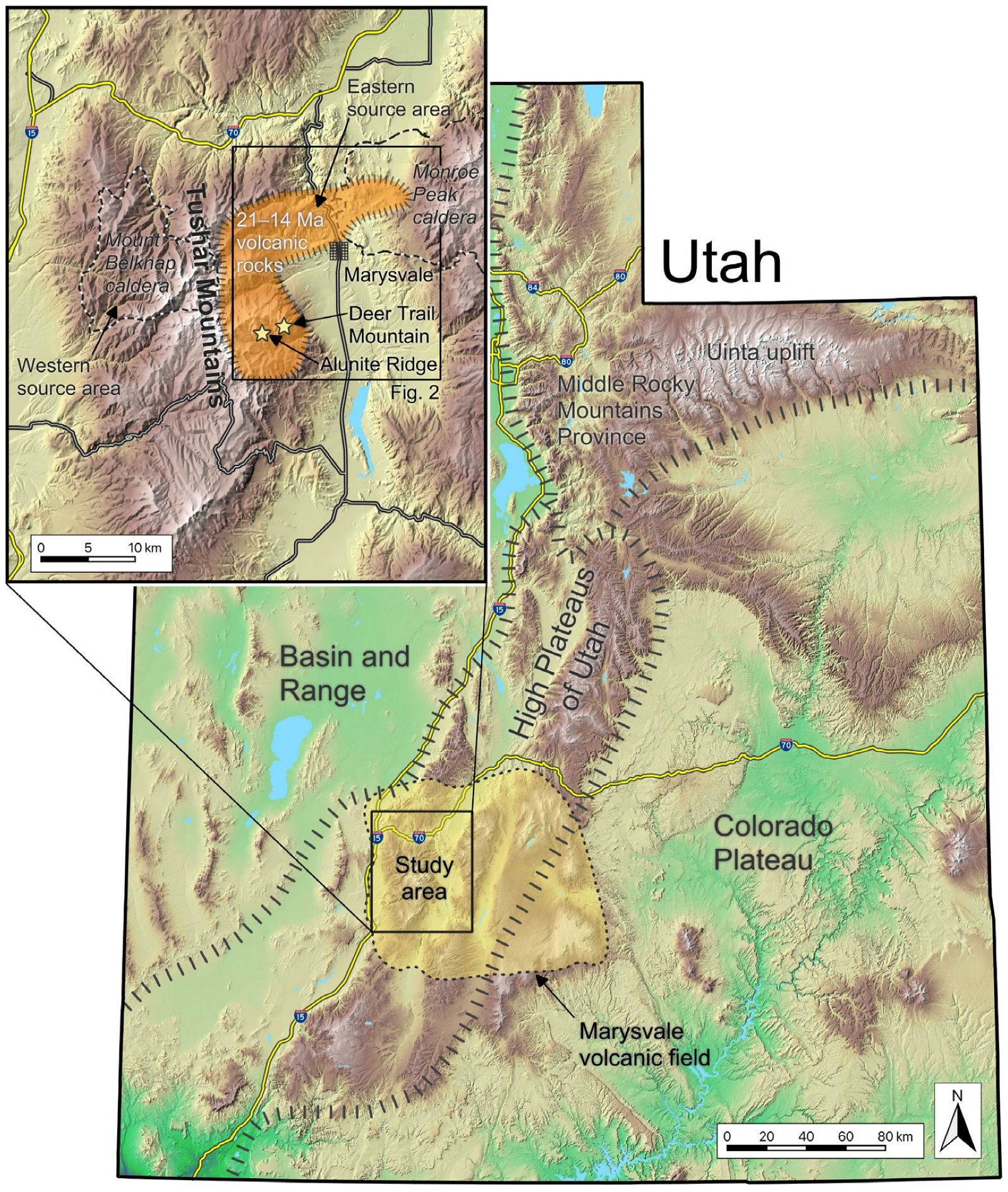
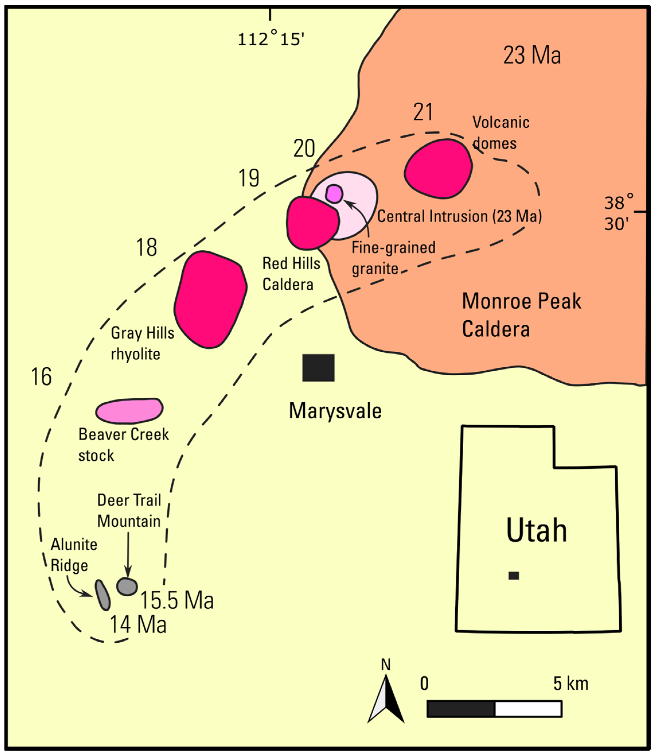
2. Geologic Setting
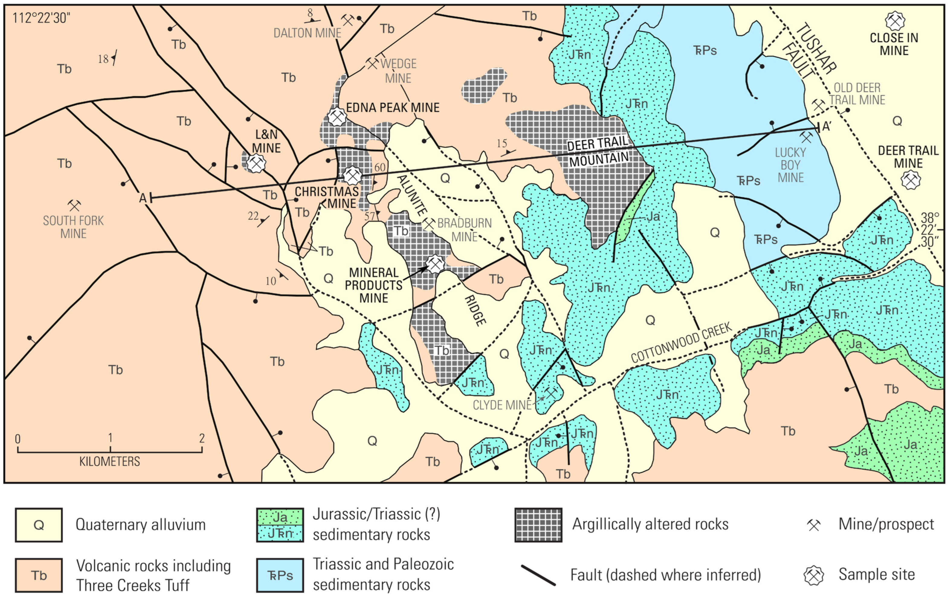
2.1. Magmatic-Steam Alunite at Marysvale, Utah
2.2. Current Mineral Exploration at Deer Trail
3. Materials and Methods
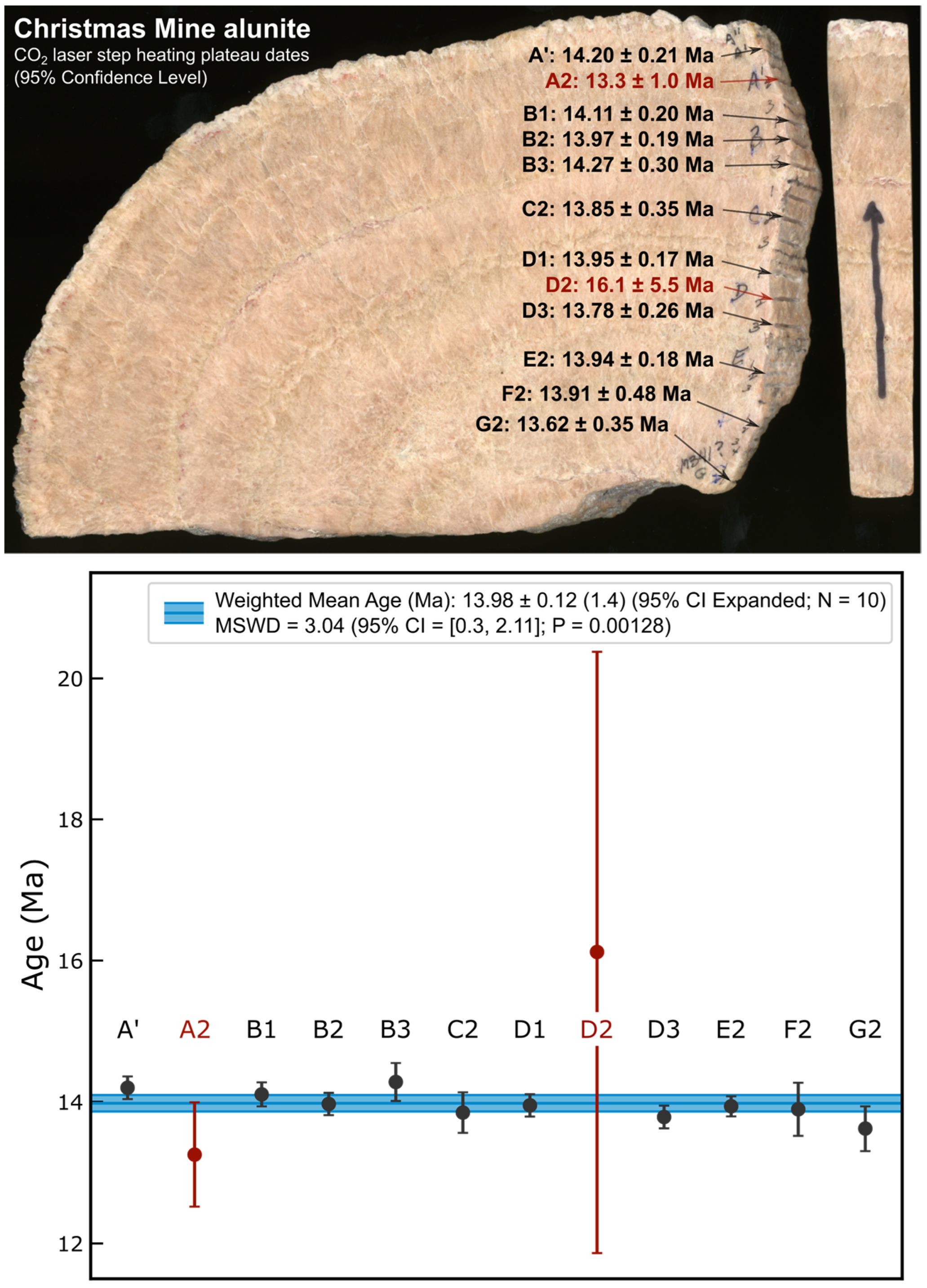
3.1. Samples
3.2. 40Ar/39Ar Geochronology Methods

| Sample | Mine/Prospect | Lab Run ID | Plateau | Total Gas | |||||||||||||||||||
|---|---|---|---|---|---|---|---|---|---|---|---|---|---|---|---|---|---|---|---|---|---|---|---|
| Age (Ma) | Age (Ma) | ||||||||||||||||||||||
| t | 1σ | 1σx | 95% CI | 95% CIx | Xpnd | %39ArK | N | 95% CI () | Algorithm | t | 1σ | 1σx | 95% CI | 95% CIx | Xpnd | N | 95% CI () | ||||||
| Magmatic-steam alunite data collected on MAP 215-50 | |||||||||||||||||||||||
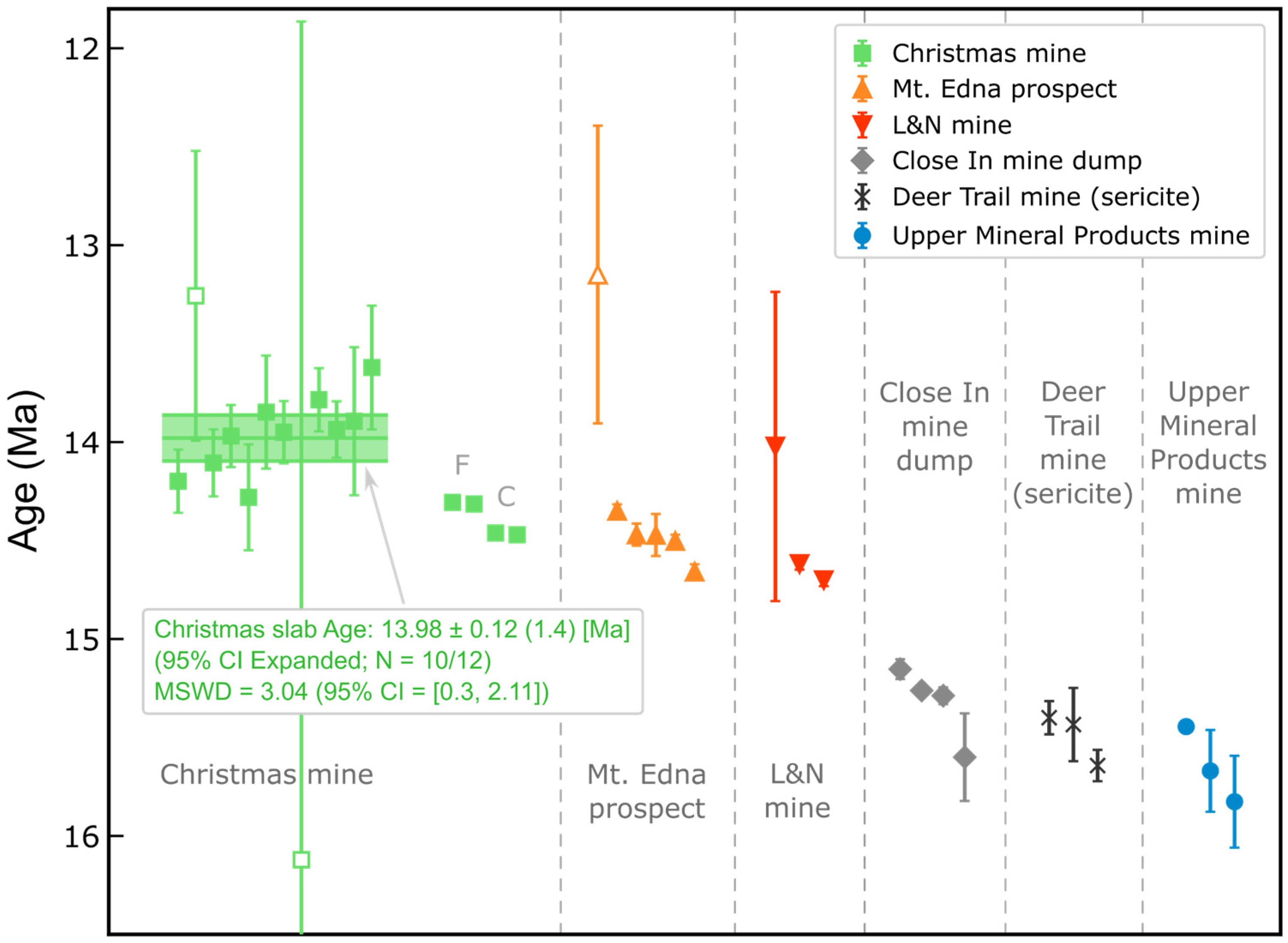
| 003-05 | Mt. Edna prospect | 112-01 | 13.1 | 0.38 | 0.45 | 1.0 | 1.2 | 100.0 | 5 | 0.997 | [0.121, 2.79] | Fleck, 1977 | 13.1 | 0.38 | 0.45 | 1.0 | 1.2 | 5 | 0.997 | [0.121, 2.79] | |||
| 005-08 | L&N mine | 108-01 | 14.02 | 0.39 | 0.47 | 0.93 | 1.1 | 100.0 | 8 | 0.289 | [0.241, 2.29] | Fleck, 1977 | 14.02 | 0.39 | 0.47 | 0.93 | 1.1 | 8 | 0.289 | [0.241, 2.29] | |||
| M341 A’ | Christmas mine | 307-01 | 14.20 | 0.080 | 0.27 | 0.21 | 0.70 | 71.7 | 6 | 1.52 | [0.166, 2.57] | Fleck, 1977 | 14.21 | 0.079 | 0.27 | 0.31 | 1.1 | X | 13 | 3.32 | [0.367, 1.94] | ||
| M341 A2 | Christmas mine | 109-01 | 13.3 | 0.37 | 0.44 | 1.0 | 1.2 | 100.0 | 5 | 1.28 | [0.121, 2.79] | Fleck, 1977 | 13.3 | 0.37 | 0.44 | 1.0 | 1.2 | 5 | 1.28 | [0.121, 2.79] | |||
| M341 B1 | Christmas mine | 308-02 | 14.11 | 0.085 | 0.27 | 0.20 | 0.63 | 100.0 | 9 | 1.17 | [0.272, 2.19] | Fleck, 1977 | 14.11 | 0.085 | 0.27 | 0.20 | 0.63 | 9 | 1.17 | [0.272, 2.19] | |||
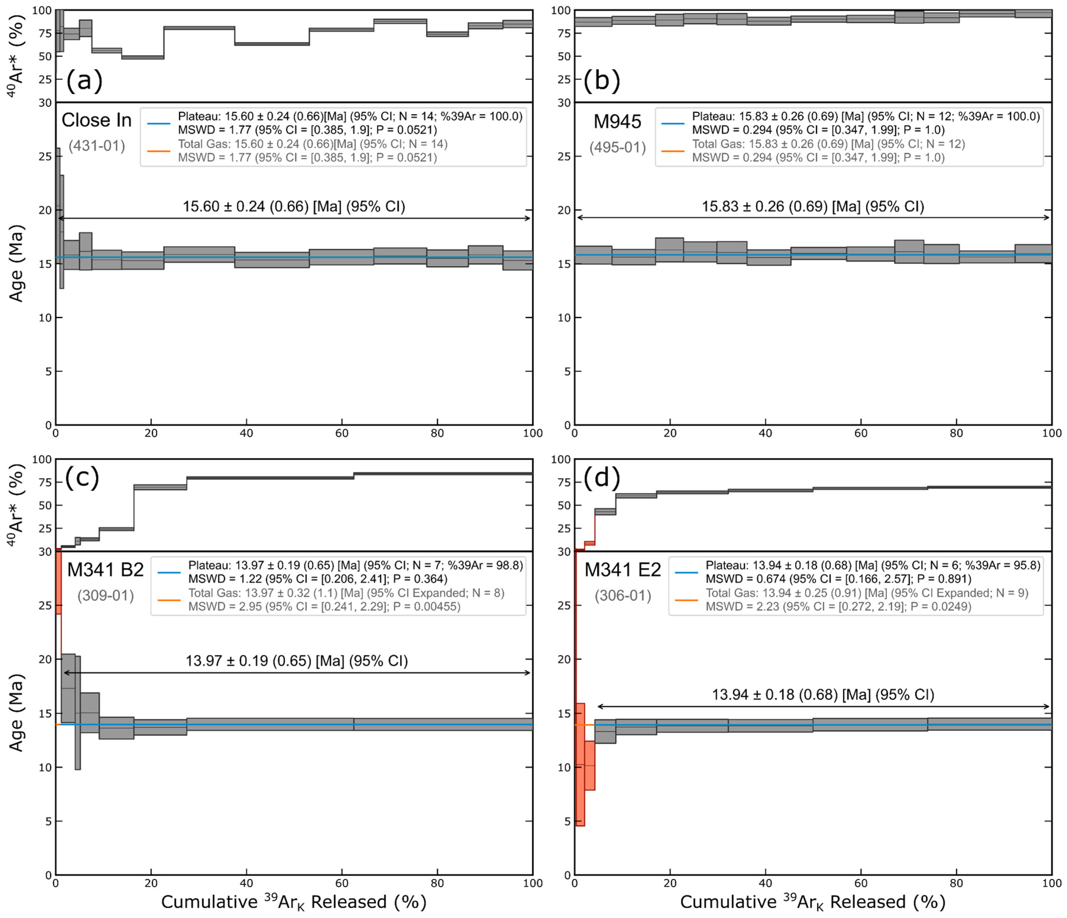
| M341 B2 | Christmas mine | 309-01 | 13.97 | 0.079 | 0.27 | 0.19 | 0.65 | 98.8 | 7 | 1.22 | [0.206, 2.41] | Fleck, 1977 | 13.97 | 0.079 | 0.27 | 0.32 | 1.1 | X | 8 | 2.95 | [0.241, 2.29] | ||
| M341 B3 | Christmas mine | 310-01 | 14.28 | 0.13 | 0.29 | 0.30 | 0.65 | 98.9 | 11 | 1.23 | [0.325, 2.05] | Fleck, 1977 | 14.28 | 0.13 | 0.29 | 0.29 | 0.64 | 13 | 1.84 | [0.367, 1.94] | |||
| M341 C2 | Christmas mine | 311-01 | 13.85 | 0.14 | 0.29 | 0.35 | 0.71 | 92.6 | 7 | 0.676 | [0.206, 2.41] | Fleck, 1977 | 13.85 | 0.14 | 0.29 | 0.31 | 0.63 | 13 | 1.62 | [0.367, 1.94] | |||
| M341 D1 | Christmas mine | 302-01 | 13.95 | 0.079 | 0.27 | 0.17 | 0.59 | 100.0 | 12 | 0.682 | [0.347, 1.99] | Fleck, 1977 | 13.95 | 0.079 | 0.27 | 0.17 | 0.59 | 12 | 0.682 | [0.347, 1.99] | |||
| M341 D2 | Christmas mine | 110-01 | 16.1 | 2.1 | 2.1 | 5.5 | 5.5 | 100.0 | 6 | 0.706 | [0.166, 2.57] | Fleck, 1977 | 16.1 | 2.1 | 2.1 | 5.5 | 5.5 | 6 | 0.706 | [0.166, 2.57] | |||
| M341 D3 | Christmas mine | 304-01 | 13.78 | 0.080 | 0.26 | 0.26 | 0.84 | 73.1 | 4 | 1.33 | [0.0719, 3.12] | Fleck, 1977 | 13.78 | 0.079 | 0.26 | 0.18 | 0.59 | 11 | 1.67 | [0.325, 2.05] | |||
| M341 E2 | Christmas mine | 306-01 | 13.94 | 0.072 | 0.26 | 0.18 | 0.68 | 95.8 | 6 | 0.674 | [0.166, 2.57] | Fleck, 1977 | 13.94 | 0.071 | 0.26 | 0.25 | 0.91 | X | 9 | 2.23 | [0.272, 2.19] | ||
| M341 F2 | Christmas mine | 111-01 | 13.89 | 0.19 | 0.32 | 0.48 | 0.81 | 100.0 | 6 | 0.930 | [0.166, 2.57] | Fleck, 1977 | 13.89 | 0.19 | 0.32 | 0.48 | 0.81 | 6 | 0.930 | [0.166, 2.57] | |||
| M341 G2 | Christmas mine | 312-01 | 13.62 | 0.16 | 0.29 | 0.35 | 0.66 | 100.0 | 11 | 0.852 | [0.325, 2.05] | Fleck, 1977 | 13.62 | 0.16 | 0.29 | 0.35 | 0.66 | 11 | 0.852 | [0.325, 2.05] | |||
| M939-1 | Upper Mineral Products mine | 429-01 | 15.67 | 0.10 | 0.30 | 0.29 | 0.85 | 53.0 | 5 | 1.73 | [0.121, 2.79] | Fleck, 1977 | 15.81 | 0.10 | 0.30 | 0.55 | 1.7 | X | 14 | 6.90 | [0.385, 1.90] | ||
| M945 | Upper Mineral Products mine | 495-01 | 15.83 | 0.12 | 0.31 | 0.26 | 0.69 | 100.0 | 12 | 0.294 | [0.347, 1.99] | Fleck, 1977 | 15.83 | 0.12 | 0.31 | 0.26 | 0.69 | 12 | 0.294 | [0.347, 1.99] | |||
| Close In | Close In mine dump | 431-01 | 15.60 | 0.11 | 0.31 | 0.24 | 0.66 | 100.0 | 14 | 1.77 | [0.385, 1.90] | Fleck, 1977 | 15.60 | 0.11 | 0.31 | 0.24 | 0.66 | 14 | 1.77 | [0.385, 1.90] | |||
| Magmatic-steam alunite data collected on Argus VI | |||||||||||||||||||||||
| 21AR01 | L&N mine | 2886-01 | 14.701 | 0.015 | 0.27 | 0.036 | 0.64 | 75.4 | 8 | 0.897 | [0.241, 2.29] | Fleck, 1977 | 14.668 | 0.015 | 0.27 | 0.077 | 1.4 | X | 15 | 6.11 | [0.402, 1.87] | ||
| 21AR01 | L&N mine | 2886-02 | 14.65 | 0.015 | 0.27 | 0.12 | 2.2 | X | 83.2 | 6 | 10.2 | [0.166, 2.57] | Forced | 14.62 | 0.014 | 0.27 | 0.24 | 4.5 | X | 13 | 60.4 | [0.367, 1.94] | |
| 21AR03 Coarse | Christmas Mine | 2888-01 | 14.471 | 0.015 | 0.27 | 0.035 | 0.61 | 77.4 | 9 | 2.08 | [0.272, 2.19] | Fleck, 1977 | 14.44 | 0.015 | 0.27 | 0.11 | 1.9 | X | 13 | 10.9 | [0.367, 1.94] | ||
| 21AR03 Coarse | Christmas Mine | 2888-02 | 14.462 | 0.014 | 0.27 | 0.032 | 0.60 | 92.8 | 10 | 1.70 | [0.300, 2.11] | Fleck, 1977 | 14.458 | 0.014 | 0.27 | 0.069 | 1.3 | X | 12 | 4.86 | [0.347, 1.99] | ||
| 21AR03 Fine | Christmas Mine | 2887-01 | 14.29 | 0.015 | 0.26 | 0.21 | 3.6 | X | 73.7 | 4 | 18.9 | [0.0719, 3.12] | Forced | 14.31 | 0.015 | 0.26 | 0.19 | 3.3 | X | 15 | 35.2 | [0.402, 1.87] | |
| 21AR03 Fine | Christmas Mine | 2887-02 | 14.30 | 0.015 | 0.26 | 0.17 | 2.8 | X | 82.9 | 4 | 11.4 | [0.0719, 3.12] | Forced | 14.31 | 0.015 | 0.26 | 0.20 | 3.4 | X | 10 | 33.5 | [0.300, 2.11] | |
| Edna 2a Fine | Mt. Edna prospect | 2891-01 | 14.502 | 0.016 | 0.27 | 0.069 | 1.1 | 60.2 | 3 | 0.669 | [0.0253, 3.69] | Fleck, 1977 | 14.47 | 0.015 | 0.27 | 0.14 | 2.6 | X | 11 | 18.6 | [0.325, 2.05] | ||
| Edna 2a Fine | Mt. Edna prospect | 2891-02 | 14.658 | 0.019 | 0.27 | 0.043 | 0.62 | 98.1 | 9 | 0.966 | [0.272, 2.19] | Fleck, 1977 | 14.658 | 0.019 | 0.27 | 0.066 | 0.95 | X | 10 | 2.45 | [0.300, 2.11] | ||
| Edna 3a Coarse | Mt. Edna prospect | 2889-01 | 14.470 | 0.028 | 0.27 | 0.065 | 0.61 | 78.4 | 9 | 1.74 | [0.272, 2.19] | Fleck, 1977 | 14.50 | 0.026 | 0.27 | 0.10 | 1.1 | X | 13 | 3.34 | [0.367, 1.94] | ||
| Edna 3a Coarse | Mt. Edna prospect | 2889-02 | 14.47 | 0.053 | 0.27 | 0.13 | 0.64 | 84.7 | 8 | 0.697 | [0.241, 2.29] | Fleck, 1977 | 14.46 | 0.053 | 0.27 | 0.12 | 0.62 | 9 | 1.99 | [0.272, 2.19] | |||
| Close In | Close In mine dump | 2892-01 | 15.153 | 0.025 | 0.28 | 0.058 | 0.64 | 54.1 | 9 | 0.461 | [0.272, 2.19] | Fleck, 1977 | 15.117 | 0.022 | 0.28 | 0.075 | 1.0 | X | 13 | 2.56 | [0.367, 1.94] | ||
| Close In | Close In mine dump | 2892-02 | 15.288 | 0.021 | 0.28 | 0.068 | 0.89 | 60.0 | 4 | 1.78 | [0.0719, 3.12] | Fleck, 1977 | 15.287 | 0.019 | 0.28 | 0.044 | 0.65 | 9 | 2.16 | [0.272, 2.19] | |||
| Deer Trail sericite data collected on Argus VI | |||||||||||||||||||||||
| M992 B1 | Deer Trail mine workings | 665-01 | 15.43 | 0.093 | 0.30 | 0.21 | 0.67 | 100.0 | 10 | 1.47 | [0.300, 2.11] | Fleck, 1977 | 15.43 | 0.093 | 0.30 | 0.21 | 0.67 | 10 | 1.47 | [0.300, 2.11] | |||
| M992 B3 | Deer Trail mine workings | 666-01 | 15.400 | 0.042 | 0.28 | 0.090 | 0.61 | 82.6 | 16 | 1.27 | [0.417, 1.83] | Fleck, 1977 | 15.47 | 0.039 | 0.28 | 0.14 | 1.0 | X | 19 | 2.79 | [0.457, 1.75] | ||
| M993 D1 | Deer Trail mine workings | 667-01 | 15.643 | 0.040 | 0.29 | 0.087 | 0.64 | 73.3 | 12 | 1.38 | [0.347, 1.99] | Fleck, 1977 | 15.57 | 0.037 | 0.29 | 0.19 | 1.5 | X | 18 | 6.11 | [0.445, 1.78] | ||
3.3. SHRIMP U/Pb Geochronology Methods
4. Results
5. Discussion
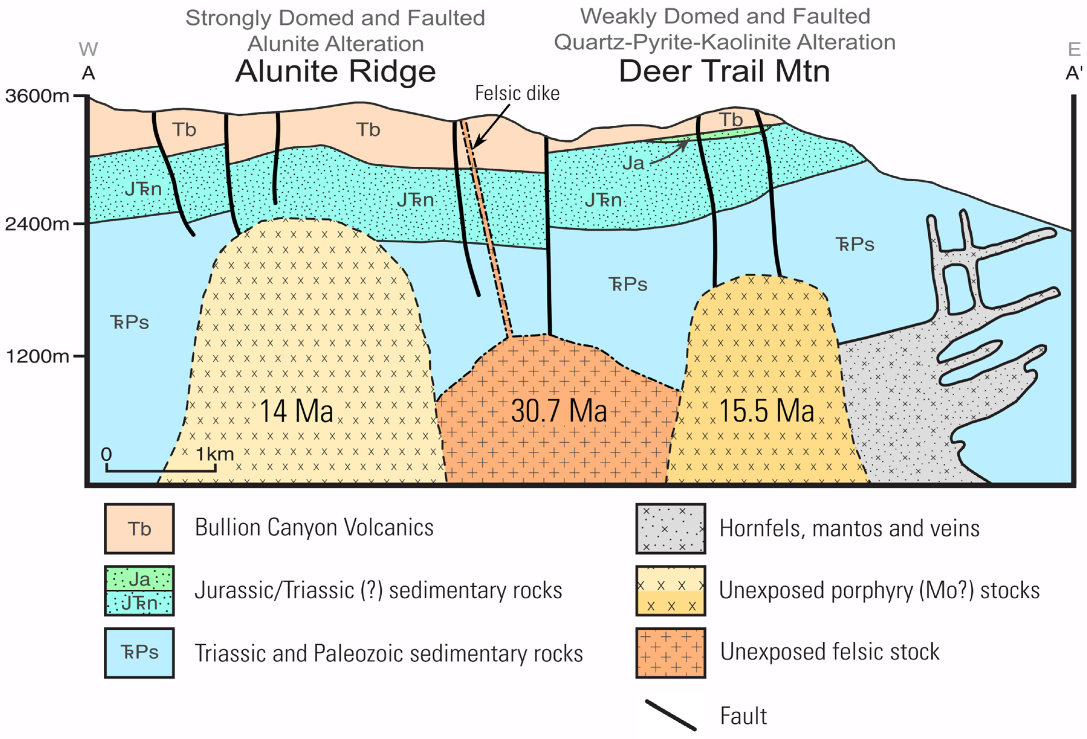
5.1. Timing of Felsic Intrusive Activity Relative to the Formation of the Three Creeks Tuff Member of the Bullion Canyon Volcanics
5.2. Timing and Spatial Distribution of Miocene Hydrothermal Activity at Alunite Ridge and Deer Trail Mountain
5.3. Relation to Regional Tectonic and Igneous Activity

5.4. Implications for Mineral Exploration
Supplementary Materials
Author Contributions
Funding
Data Availability Statement
Acknowledgments
Conflicts of Interest
References
- Dilles, J.H.; John, D.A. Porphyry and Epithermal Mineral Deposits. In Encyclopedia of Geology; Alderton, D., Elias, S.A., Eds.; Academic Press: Cambridge, MA, USA, 2021; pp. 847–866. [Google Scholar]
- Wang, L.; Qin, K.-Z.; Song, G.-X.; Li, G.-M. A Review of Intermediate Sulfidation Epithermal Deposits and Subclassification. Ore Geol. Rev. 2019, 107, 434–456. [Google Scholar] [CrossRef]
- Kirkham, R.V. Intermineral Intrusions and Their Bearing on the Origin of Porphyry Copper and Molybdenum Deposits. Econ. Geol. 1971, 66, 1244–1249. [Google Scholar] [CrossRef]
- Cathles, L.M.; Erendi, A.H.J.; Barrie, T. How Long Can a Hydrothermal System Be Sustained by a Single Intrusive Event? Econ. Geol. 1997, 92, 766–771. [Google Scholar] [CrossRef]
- Chelle-Michou, C.; Rottier, B.; Caricchi, L.; Simpson, G. Tempo of Magma Degassing and the Genesis of Porphyry Copper Deposits. Sci. Rep. 2016, 7, 40566. [Google Scholar] [CrossRef] [PubMed]
- von Quadt, A.; Erni, M.; Martinek, K.; Moll, M.; Peytcheva, I.; Heinrich, C.A. Zircon Crystallization and the Lifetimes of Ore-Forming Magmatic-Hydrothermal Systems. Geology 2011, 39, 731–734. [Google Scholar] [CrossRef]
- Catchpole, H.; Kouzmanov, K.; Bendezú, A.; Ovtcharova, M.; Spikings, R.; Stein, H.; Fontboté, L. Timing of Porphyry (Cu-Mo) and Base Metal (Zn-Pb-Ag-Cu) Mineralisation in a Magmatic-Hydrothermal System—Morococha District, Peru. Miner. Depos. 2015, 50, 895–922. [Google Scholar] [CrossRef]
- Spencer, E.T.; Wilkinson, J.J.; Creaser, R.A.; Seguel, J. The Distribution and Timing of Molybdenite Mineralization at the El Teniente Cu-Mo Porphyry Deposit, Chile. Econ. Geol. 2015, 110, 387–421. [Google Scholar] [CrossRef]
- Rosera, J.M.; Coleman, D.S.; Stein, H.J. Re-evaluating Genetic Models for Porphyry Mo Mineralization at Questa, New Mexico: Implications for Ore Deposition Following Silicic Ignimbrite Eruption. Geochem. Geophys. Geosyst. 2013, 14, 787–805. [Google Scholar] [CrossRef]
- Gaynor, S.P.; Rosera, J.M.; Coleman, D.S. Intrusive History of the Oligocene Questa Porphyry Molybdenum Deposit, New Mexico. Geosphere 2019, 15, 548–575. [Google Scholar] [CrossRef]
- Chiaradia, M. Gold Endowments of Porphyry Deposits Controlled by Precipitation Efficiency. Nat. Commun. 2020, 11, 248. [Google Scholar] [CrossRef]
- Rye, R.O. A Review of the Stable-Isotope Geochemistry of Sulfate Minerals in Selected Igneous Environments and Related Hydrothermal Systems. Chem. Geol. 2005, 215, 5–36. [Google Scholar] [CrossRef]
- Cunningham, C.G.; Rye, R.O.; Steven, T.A.; Mehnert, H.H. Origins and Exploration Significance of Replacement and Vein-Type Alunite Deposits in the Marysvale Volcanic Field, West Central Utah. Econ. Geol. 1984, 79, 50–71. [Google Scholar] [CrossRef]
- Beaty, D.W.; Cunningham, C.G.; Rye, R.O.; Steven, T.A.; Gonzalez-Urien, E. Geology and Geochemistry of the Deer Trail Pb-Zn-Ag-Au-Cu Manto Deposits, Marysvale District, West-Central Utah. Econ. Geol. 1986, 81, 1932–1952. [Google Scholar] [CrossRef]
- Steven, T.A.; Cunningham, C.G.; Naeser, C.W.; Mehnert, H.H. Revised Stratigraphy and Radiometric Ages of Volcanic Rocks and Mineral Deposits in the Marysvale Area, West-Central Utah; Geological Survey Bulletin 1469; U.S. Geological Survey: Liston, VA, USA, 1979; 40p. [Google Scholar]
- Cunningham, C.G.; Rasmussen, J.D.; Steven, T.A.; Rye, R.O.; Rowley, P.D.; Romberger, S.B.; Selverstone, J. Hydrothermal Uranium Deposits Containing Molybdenum and Fluorite in the Marysvale Volcanic Field, West-Central Utah. Miner. Depos. 1998, 33, 477–494. [Google Scholar] [CrossRef]
- Rowley, P.D.; Cunningham, C.G.; Anderson, J.J.; Steven, T.A.; Workman, J.B.; Snee, L.W. Geology and Mineral Resources Of The Marysvale Volcanic Field, Southwestern Utah. In Proceedings of the Rocky Mountain Section Annual Meeting, Cedar City, UT, USA, 7–9 May 2002; Geological Society of America: Boulder, CO, USA, 2002. [Google Scholar]
- Cunningham, C.G.; Ludwig, K.R.; Naeser, C.W.; Weiland, E.K.; Mehnert, H.H.; Steven, T.A.; Rasmussen, J.D. Geochronology of Hydrothermal Uranium Deposits and Associated Igneous Rocks in the Eastern Source Area of the Mount Belknap Volcanics, Marysvale, Utah. Econ. Geol. 1982, 77, 453–463. [Google Scholar] [CrossRef]
- Callaghan, E. Mineral Resource Potential of Piute County, Utah and Adjoining Area; Utah Geological and Mineralogical Survey Bulletin 102; Utah Geological and Mineralogical Survey: Salt Lake City, UT, USA, 1973. [Google Scholar]
- Cunningham, C.G.; Rye, R.O.; Rockwell, B.W.; Kunk, M.J.; Councell, T.B. Supergene Destruction of a Hydrothermal Replacement Alunite Deposit at Big Rock Candy Mountain, Utah: Mineralogy, Spectroscopic Remote Sensing, Stable-Isotope, and Argon-Age Evidences. Chem. Geol. 2005, 215, 317–337. [Google Scholar] [CrossRef][Green Version]
- Landis, G.P.; Rye, R.O. Characterization of Gas Chemistry and Noble-Gas Isotope Ratios of Inclusion Fluids in Magmatic-Hydrothermal and Magmatic-Steam Alunite. Chem. Geol. 2005, 215, 155–184. [Google Scholar] [CrossRef]
- Rye, R.O.; Bethke, P.M.; Wasserman, M.D. The Stable Isotope Geochemistry of Acid Sulfate Alteration. Econ. Geol. 1992, 87, 225–262. [Google Scholar] [CrossRef]
- Bassett, W.A.; Kerr, P.F.; Schaeffer, O.A.; Stoenner, R.W. Potassium-Argon Dating of the Late Tertiary Volcanic Rocks and Mineralization of Marysvale, Utah. GSA Bull. 1963, 74, 213–220. [Google Scholar] [CrossRef]
- Caskey, C.F.; Shuey, R.T. Mid-Tertiary Volcanic Stratigraphy, Sevier-Cove Fort Area, Central Utah. Utah Geol. 1975, 2, 17–25. [Google Scholar] [CrossRef]
- Rowley, P.D.; Mehnert, H.H.; Naeser, C.W.; Snee, L.W.; Cunningham, C.G.; Steven, T.A.; Anderson, J.J.; Sable, E.G.; Anderson, R.E. Isotopic Ages and Stratigraphy of Cenozoic Rocks of the Marysvale Volcanic Field and Adjacent Areas, West-Central Utah; U.S. Geological Survey Bulletin 2071; U.S. Geological Survey: Liston, VA, USA, 1994; p. 35. [Google Scholar]
- Best, M.G.; Christiansen, E.H.; Deino, A.L.; Gromme, S.; Hart, G.L.; Tingey, D.G. The 36–18 Ma Indian Peak–Caliente Ignimbrite Field and Calderas, Southeastern Great Basin, USA: Multicyclic Super-Eruptions. Geosphere 2013, 9, 864–950. [Google Scholar] [CrossRef]
- Waltenberg, K.M. Mineral Physics and Crystal Chemistry of Minerals Suitable for Weathering Geochronology: Implications to 40Ar/39Ar and (U-Th)/He Geochronology. Ph.D. Thesis, The University of Queensland, Brisbane, Australia, 2012. [Google Scholar]
- Ren, Z.; Vasconcelos, P.M. Argon Diffusion in Hypogene and Supergene Alunites: Implications to Geochronology and Thermochronometry on Earth and Mars. Geochim. Cosmochim. Acta 2019, 262, 166–187. [Google Scholar] [CrossRef]
- MAG Silver Corp. MAG Silver Reports Successful Phase 1 Deer Trail Drilling Results. MAG Silver Corporate News Reports, 2021. Available online: https://magsilver.com/news/mag-silver-reports-successful-phase-1-deer-trail-drilling-results/ (accessed on 24 August 2022).
- MAG Silver Corp. Deer Trail Technical Presentation, MAG Silver Corporate Videos, 2020. Available online: https://magsilver.com/investors/corporate-videos/ (accessed on 24 August 2022).
- Rowley, P.D.; Cunningham, C.G.; Steven, T.A.; Workman, J.B.; Anderson, J.J.; Theissen, K.M. Geologic Map of the Central Marysvale Volcanic Field, Southwestern Utah; U.S. Geological Survey: Denver, CO, USA, 2002; IMAP 2645-A. [Google Scholar] [CrossRef]
- Dalrymple, G.B.; Alexander, E.C., Jr.; Lanphere, M.A.; Kraker, G.P. Irradiation of Samples for 40Ar/39Ar Dating Using the Geological Survey TRIGA Reactor; Geological Survey Professional Paper 1176; U.S. Geological Survey: Washington, DC, USA, 1981; 55p. [Google Scholar]
- Turrin, B.D.; Swisher, C.C.; Deino, A.L. Mass Discrimination Monitoring and Intercalibration of Dual Collectors in Noble Gas Mass Spectrometer Systems. Geochem. Geophys. Geosyst. 2010, 11, Q0AA09. [Google Scholar] [CrossRef]
- Lee, J.-Y.; Marti, K.; Severinghaus, J.P.; Kawamura, K.; Yoo, H.-S.; Lee, J.B.; Kim, J.S. A Redetermination of the Isotopic Abundances of Atmospheric Ar. Geochim. Cosmochim. Acta 2006, 70, 4507–4512. [Google Scholar] [CrossRef]
- Fleck, R.J.; Sutter, J.F.; Elliot, D.H. Interpretation of Discordant 40Ar/39Ar Age-Spectra of Mesozoic Tholeiites from Antarctica. Geochim. Cosmochim. Acta 1977, 41, 15–32. [Google Scholar] [CrossRef]
- Kuiper, K.F.; Deino, A.; Hilgen, F.J.; Krijgsman, W.; Renne, P.R.; Wijbrans, J.R. Synchronizing Rock Clocks of Earth History. Science 2008, 320, 500–504. [Google Scholar] [CrossRef]
- Min, K.; Mundil, R.; Renne, P.R.; Ludwig, K.R. A Test for Systematic Errors in 40Ar/39Ar Geochronology through Comparison with U/Pb Analysis of a 1.1-Ga Rhyolite. Geochim. Cosmochim. Acta 2000, 64, 73–98. [Google Scholar] [CrossRef]
- Mercer, C.M.; Hodges, K.V. ArAR—A Software Tool to Promote the Robust Comparison of K–Ar and 40Ar/39Ar Dates Published Using Different Decay, Isotopic, and Monitor-Age Parameters. Chem. Geol. 2016, 440, 148–163. [Google Scholar] [CrossRef]
- Pearson, R.K. Exploring Data in Engineering, the Sciences, and Medicine; Oxford University Press: New York, NY, USA, 2011; 770p. [Google Scholar]
- Mahon, K.I. The New York Regression: Application of an Improved Statistical Method to Geochemistry. Int. Geol. Rev. 1996, 38, 293–303. [Google Scholar] [CrossRef]
- York, D.; Evensen, N.M.; Martínez, M.L.; Delgado, J.D.B. Unified Equations for the Slope, Intercept, and Standard Errors of the Best Straight Line. Am. J. Phys. 2004, 72, 367–375. [Google Scholar] [CrossRef]
- Wendt, I.; Carl, C. The Statistical Distribution of the Mean Squared Weighted Deviation. Chem. Geol. Isot. Geosci. Sect. 1991, 86, 275–285. [Google Scholar] [CrossRef]
- Black, L.P.; Kamo, S.L.; Allen, C.M.; Davis, D.W.; Aleinikoff, J.N.; Valley, J.W.; Mundil, R.; Campbell, I.H.; Korsch, R.J.; Williams, I.S.; et al. Improved 206Pb/238U Microprobe Geochronology by the Monitoring of a Trace-Element-Related Matrix Effect: SHRIMP, ID–TIMS, ELA–ICP–MS and Oxygen Isotope Documentation for a Series of Zircon Standards. Chem. Geol. 2004, 205, 115–140. [Google Scholar] [CrossRef]
- Williams, I.S. U-Th-Pb Geochronology by Ion Microprobe; Not Just Ages but Histories. In Applications of Microanalytical Techniques to Understanding Mineralizing Processes; McKibben, M.A., Shanks, W.C., Ridley, W.I., Eds.; Society of Economic Geologists Reviews in Economic Geology: Littleton, CO, USA, 1998; Volume 7, pp. 1–35. [Google Scholar]
- Ireland, T.R.; Williams, I.S. Considerations in Zircon Geochronology by SIMS. Rev. Mineral. Geochem. 2003, 53, 215–241. [Google Scholar] [CrossRef]
- Ludwig, K.R. SQUID 1.02, A Users Manual; Berkeley Geochronology Center Special Publication 2; Berkeley Geochronology Center: Berkeley, CA, USA, 2001; 19p. [Google Scholar]
- McDonough, W.F.; Sun, S. The Composition of the Earth. Chem. Geol. 1995, 120, 223–253. [Google Scholar] [CrossRef]
- Mercer, C.M.; Cosca, M.A.; Premo, W.R. Argon and SHRIMP-RG Data for Magmatic Steam Alunite, Sericite, and Zircon from Alunite Ridge and Deer Trail Mountain, Marysvale, Utah. U.S. Geol. Surv. Data Release 2022. [Google Scholar] [CrossRef]
- Love, D.A.; Clark, A.H.; Hodgson, C.J.; Mortensen, J.K.; Archibald, D.A.; Farrar, E. The Timing of Adularia-Sericite-Type Mineralization and Alunite-Kaolinite-Type Alteration, Mount Skukum Epithermal Gold Deposit, Yukon Territory, Canada; 40Ar- 39Ar and U-Pb Geochronology. Econ. Geol. 1998, 93, 437–462. [Google Scholar] [CrossRef]
- Landis, G.P.; Snee, L.W.; Juliani, C. Evaluation of Argon Ages and Integrity of Fluid-Inclusion Compositions: Stepwise Noble Gas Heating Experiments on 1.87 Ga Alunite from Tapajós Province, Brazil. Chem. Geol. 2005, 215, 127–153. [Google Scholar] [CrossRef]
- Landis, G.P.; Rye, R.O. Fluid Inclusion Active and Noble Gases in Coarse-Banded Alunite Veins at Alunite Ridge, Marysvale, Utah, and Implications for Crust-Mantle Magmatic Volatile Evolution [abs]. Geol. Soc. Am. Abstr. Programs 2009, 41, 525. [Google Scholar]
- Morgan, L.E.; Johnstone, S.A.; Gilmer, A.K.; Cosca, M.A.; Thompson, R.A. A Supervolcano and Its Sidekicks: A 100 Ka Eruptive Chronology of the Fish Canyon Tuff and Associated Units of the La Garita Magmatic System, Colorado, USA. Geology 2019, 47, 453–456. [Google Scholar] [CrossRef]
- Cunningham, C.G.; Steven, T.A. Geologic Map of the Deer Trail Mountain-Alunite Ridge Mining Area, West-Central Utah; U.S. Geological Survey Miscellaneous Investigation Series; U.S. Geological Survey: Liston, VA, USA, 1979; Map I-1230, Scale 1:24,000. [Google Scholar] [CrossRef]
- Best, M.G.; McKee, E.H.; Damon, P.E. Space-Time-Composition Patterns of Late Cenozoic Mafic Volcanism, Southwestern Utah and Adjoining Areas. Am. J. Sci. 1980, 280, 1035–1050. [Google Scholar] [CrossRef]
- Lipman, P.W.; Prostka, H.J.; Christiansen, R.L. Evolving Subduction Zones in the Western United States, as Interpreted from Igneous Rocks. Science 1971, 174, 821–825. [Google Scholar] [CrossRef] [PubMed]
- Dickinson, W.R. The Basin and Range Province as a Composite Extensional Domain. Int. Geol. Rev. 2002, 44, 1–38. [Google Scholar] [CrossRef]
- Best, M.G.; Christiansen, E.H.; de Silva, S.; Lipman, P.W. Slab-Rollback Ignimbrite Flareups in the Southern Great Basin and Other Cenozoic American Arcs: A Distinct Style of Arc Volcanism. Geosphere 2016, 12, 1097–1135. [Google Scholar] [CrossRef]
- McQuarrie, N.; Oskin, M. Palinspastic Restoration of NAVDat and Implications for the Origin of Magmatism in Southwestern North America. J. Geophys. Res. Solid Earth 2010, 115, B10401. [Google Scholar] [CrossRef]
- Glazner, A.F. Cenozoic Magmatism and Plate Tectonics in Western North America: Have We Got It Wrong? In In the Footsteps of Warren B. Hamilton: New Ideas in Earth Science; Foulger, G.R., Hamilton, L.C., Jurdy, D.M., Stein, C.A., Howard, K.A., Stein, S., Eds.; Geological Society of America Special Paper 553; The Geological Society of America: Boulder, CO, USA, 2022; pp. 95–108. [Google Scholar]
- Humphreys, E.; Hessler, E.; Dueker, K.; Farmer, G.L.; Erslev, E.; Atwater, T. How Laramide-Age Hydration of North American Lithosphere by the Farallon Slab Controlled Subsequent Activity in the Western United States. Int. Geol. Rev. 2003, 45, 575–595. [Google Scholar] [CrossRef]
- Humphreys, E. Relation of Flat Subduction to Magmatism and Deformation in the Western United States. In Backbone of the Americas: Shallow Subduction, Plateau Uplift, and Ridge and Terrane Collision; Kay, S.M., Ramos, V.A., Dickinson, W.R., Eds.; The Geological Society of America: Boulder, CO, USA, 2009; Volume 204, pp. 85–98. ISBN 9780813712048. [Google Scholar]
- Rosera, J.M.; Gaynor, S.P.; Frazer, R.E. The Magmatic Duration of Climax-type Porphyry Mo Systems. In Proceedings of the SEG 2022 Meeting: Minerals for Our Future, Denver, CO, USA, 27–30 August 2022. Abstract P5.07. [Google Scholar]
- Keith, J.D.; Shanks, W.C.; Archibald, D.A.; Farrar, E. Volcanic and Intrusive History of the Pine Grove Porphyry Molybdenum System, Southwestern Utah. Econ. Geol. 1986, 81, 553–577. [Google Scholar] [CrossRef]
- Mercer, C.N.; Hofstra, A.H.; Todorov, T.I.; Roberge, J.; Burgisser, A.; Adams, D.T.; Cosca, M. Pre-Eruptive Conditions of the Hideaway Park Topaz Rhyolite: Insights into Metal Source and Evolution of Magma Parental to the Henderson Porphyry Molybdenum Deposit, Colorado. J. Petrol. 2015, 56, 645–679. [Google Scholar] [CrossRef]


| Sample | Lab Run ID | Inverse Variance-Weighted Mean | |||||||||
|---|---|---|---|---|---|---|---|---|---|---|---|
| Age (Ma) | |||||||||||
| Mine/Prospect | t | 1σ | 1σx | 95% CI | 95% CIx | Xpnd | N | 95% CI ( | |||
| Data collected on Argus VI | |||||||||||
| 002-05 | Mt. Edna prospect | 2894 | 14.349 | 0.0163 | 0.26 | 0.033 | 0.54 | 27 | 1.35 | [0.532, 1.61] | |
| M939A | Upper Mineral Products mine | 2893 | 15.445 | 0.0089 | 0.28 | 0.018 | 0.59 | 23 | 1.25 | [0.499, 1.67] | |
| ROR MV-1-06 | Close-In mine dump | 2921 | 15.262 | 0.0073 | 0.28 | 0.020 | 0.75 | X | 24 | 1.68 | [0.508, 1.66] |
| 207Pb Corrected | 204Pb Corrected | 204Pb Corrected | |||||||||||||||||||||||
|---|---|---|---|---|---|---|---|---|---|---|---|---|---|---|---|---|---|---|---|---|---|---|---|---|---|
| Spot Name | Spot Location | Common 206Pb (%) | U ppm | Th ppm | 232Th/238U | Total 238U/206Pb | % 1σ Error | Total 207Pb/206Pb | % 1σ Error | 206Pb/238U Age (Ma) | 1σ Error (Ma) | 238U/206Pb | % 1σ Error | 207Pb/206Pb | % 1σ Error | Radiogenic 207Pb/235U | % 1σ Error | Radiogenic 206Pb/238U | % 1σ Error | r | 207Pb/206Pb Age (Ma) | 1σ Error (Ma) | Discordance (%) | ||
| M945-1C | magmatic center | 0.07 | 335 | 179 | 0.55 | 208.17 | 1.50 | 0.0472 | 6.82 | 30.87 | 0.48 | 210.32 | 1.66 | 0.0390 | 17.25 | 0.0256 | 17.33 | 0.00476 | 1.66 | 0.10 | |||||
| M945-2T | magmatic mantle | 1.03 | 199 | 142 | 0.74 | 211.13 | 1.90 | 0.0548 | 7.98 | 30.15 | 0.60 | 215.51 | 2.32 | 0.0385 | 30.62 | 0.0247 | 30.71 | 0.00464 | 2.32 | 0.08 | |||||
| M945-3T | magmatic mantle | −0.22 | 351 | 177 | 0.52 | 211.35 | 1.45 | 0.0449 | 6.75 | 30.50 | 0.46 | 212.82 | 1.51 | 0.0393 | 11.91 | 0.0255 | 12.01 | 0.00470 | 1.51 | 0.13 | |||||
| M945-4 | magmatic mantle | 0.61 | 307 | 135 | 0.46 | 210.43 | 1.55 | 0.0514 | 6.76 | 30.38 | 0.49 | 213.30 | 1.85 | 0.0407 | 22.06 | 0.0263 | 22.13 | 0.00469 | 1.85 | 0.08 | |||||
| M945-5 | magmatic mantle | 0.31 | 398 | 223 | 0.58 | 205.85 | 1.33 | 0.0491 | 5.93 | 31.14 | 0.43 | 207.16 | 1.38 | 0.0441 | 10.00 | 0.0294 | 10.09 | 0.00483 | 1.38 | 0.14 | |||||
| M945-6.1 | magmatic center | 0.09 | 275 | 210 | 0.79 | 206.84 | 1.65 | 0.0474 | 7.36 | 31.06 | 0.53 | 209.87 | 1.90 | 0.0358 | 23.66 | 0.0235 | 23.73 | 0.00477 | 1.90 | 0.08 | |||||
| M945-6.2 | magmatic mantle | 1.06 | 383 | 202 | 0.54 | 213.37 | 1.40 | 0.0550 | 5.99 | 29.82 | 0.43 | 214.83 | 1.46 | 0.0496 | 9.67 | 0.0319 | 9.77 | 0.00466 | 1.46 | 0.15 | |||||
| M945-7.1 | unzoned core | 1.44 | 220 | 65 | 0.31 | 3.8236 | 0.56 | 0.1049 | 0.76 | 1478.4 | 8.1 | 3.8249 | 0.56 | 0.1046 | 0.78 | 3.7715 | 0.96 | 0.26143 | 0.56 | 0.58 | 1708 | 14 | 14.1 | ||
| M945-7.2 | unzoned core | 0.92 | 106 | 34 | 0.33 | 3.6067 | 0.79 | 0.1048 | 1.07 | 1565 | 12 | 3.6092 | 0.79 | 0.1042 | 1.11 | 3.9802 | 1.36 | 0.27705 | 0.79 | 0.58 | 1700 | 20 | 7.8 | ||
| M945-7.3 | magmatic mantle | −0.40 | 430 | 249 | 0.60 | 209.54 | 1.29 | 0.0434 | 6.13 | 30.82 | 0.41 | 217.31 | 1.87 | 0.0140 | 84.51 | 0.0089 | 84.54 | 0.00461 | 1.87 | 0.02 | |||||
| M945-8.1 | light-CL core | 3.33 | 163 | 62 | 0.39 | 5.0548 | 0.77 | 0.1053 | 1.02 | 1128.1 | 8.5 | 5.0576 | 0.77 | 0.1049 | 1.06 | 2.8584 | 1.32 | 0.19771 | 0.77 | 0.59 | 1712 | 20 | 47.2 | ||
| M945-8.2 | magmatic mantle | 0.43 | 179 | 101 | 0.58 | 207.18 | 2.04 | 0.0500 | 8.83 | 30.91 | 0.65 | 212.89 | 2.65 | 0.0283 | 52.56 | 0.0184 | 52.63 | 0.00470 | 2.65 | 0.05 | |||||
| M945-9 | magmatic mantle | 16.92 | 283 | 173 | 0.63 | 168.61 | 1.40 | 0.1805 | 3.75 | 31.69 | 0.56 | 201.07 | 3.90 | 0.0540 | 56.64 | 0.0372 | 56.77 | 0.00500 | 3.90 | 0.07 | |||||
Publisher’s Note: MDPI stays neutral with regard to jurisdictional claims in published maps and institutional affiliations. |
© 2022 by the authors. Licensee MDPI, Basel, Switzerland. This article is an open access article distributed under the terms and conditions of the Creative Commons Attribution (CC BY) license (https://creativecommons.org/licenses/by/4.0/).
Share and Cite
Mercer, C.M.; Cosca, M.A.; Hofstra, A.H.; Premo, W.R.; Rye, R.O.; Landis, G.P. 40Ar/39Ar Geochronology of Magmatic-Steam Alunite from Alunite Ridge and Deer Trail Mountain, Marysvale Volcanic Field, Utah: Timing and Duration of Miocene Hydrothermal Activity Associated with Concealed Intrusions. Minerals 2022, 12, 1533. https://doi.org/10.3390/min12121533
Mercer CM, Cosca MA, Hofstra AH, Premo WR, Rye RO, Landis GP. 40Ar/39Ar Geochronology of Magmatic-Steam Alunite from Alunite Ridge and Deer Trail Mountain, Marysvale Volcanic Field, Utah: Timing and Duration of Miocene Hydrothermal Activity Associated with Concealed Intrusions. Minerals. 2022; 12(12):1533. https://doi.org/10.3390/min12121533
Chicago/Turabian StyleMercer, Cameron M., Michael A. Cosca, Albert H. Hofstra, Wayne R. Premo, Robert O. Rye, and Gary P. Landis. 2022. "40Ar/39Ar Geochronology of Magmatic-Steam Alunite from Alunite Ridge and Deer Trail Mountain, Marysvale Volcanic Field, Utah: Timing and Duration of Miocene Hydrothermal Activity Associated with Concealed Intrusions" Minerals 12, no. 12: 1533. https://doi.org/10.3390/min12121533
APA StyleMercer, C. M., Cosca, M. A., Hofstra, A. H., Premo, W. R., Rye, R. O., & Landis, G. P. (2022). 40Ar/39Ar Geochronology of Magmatic-Steam Alunite from Alunite Ridge and Deer Trail Mountain, Marysvale Volcanic Field, Utah: Timing and Duration of Miocene Hydrothermal Activity Associated with Concealed Intrusions. Minerals, 12(12), 1533. https://doi.org/10.3390/min12121533