Article

The Mesozoic Tectonic Transition from Compression to Extension in the South China Block: Insight from Structural Deformation of the Lushan Massif, SE China

1
School of Tourism and Public Management, Huzhou Vocational & Technical College, Huzhou 313000, China
2
School of Resources and Environmental Engineering, Hefei University of Technology, Hefei 230009, China
*
Author to whom correspondence should be addressed.
Minerals 2022, 12(12), 1531; https://doi.org/10.3390/min12121531
Submission received: 7 November 2022 / Revised: 24 November 2022 / Accepted: 25 November 2022 / Published: 29 November 2022

Abstract

:
The Lushan Massif has been considered an extensional dome which represents a typical extensional structure in South China. However, the composition and structure of the Lushan Massif are still unclear. In this study, we identified the eastern detachment fault (EDF) for the first time. In addition, many sinistral strike-slip structures have also been recognized in the Lushan area, such as the Xingzi shear zone (XZSZ) and Lianhua shear zone (LHSZ). Detailed field observation and structural analysis revealed that the former sinistral faults are tectonic boundaries of the later Lushan extensional dome (LSED). The tectonic evolution sequence was established after the structural analysis combined with zircon U-Pb dating and mica 40Ar-39Ar dating of metamorphic rocks, veins, and intrusive rocks from the strike-slip fault and detachment fault. The Lushan Massif has undergone sinistral ductile shearing within 162–150 Ma. The LSED was then formed in an extensional tectonic setting from 140 to 114 Ma. Together with the regional geological setting, we believe that the sinistral strike-slip structures, represented by the XZSZ and LHSZ, are coeval with the Tanlu fault system and could be controlled by a transpressional stress field resulting from the subduction of the Pacific Plate. The LSED was formed in a back-arc extension setting resulting from the rollback of a subducted slab. The tectonic transition from compression to extension in the South China Block took place at 150–140 Ma.

1. Introduction

Parallel with the tectonic evolution of the eastern North China Craton, the extensional structures of South China in the Mesozoic, such as extensional domes, metamorphic core complexes, magmatism, and extensional basins, which are the result of lithospheric thinning, can be observed [1,2,3,4,5,6,7,8,9]. There is always a hotspot problem in research on lithospheric thinning mechanisms. The three most widely accepted models are asthenosphere heat–chemical erosion [10,11,12,13,14], delamination of lithospheric root [15,16,17,18,19,20,21,22], and mantle plume tectonics [23]. The Late Mesozoic extensional time and direction in eastern China are coincident with those of the Pacific plate subduction; therefore, many scholars believe that Pacific plate subduction generated lithospheric thinning and crustal extension [24,25,26,27,28,29,30]. In this model, the extension under delamination was produced from the gravitational collapse of the thickened lithosphere root, resulting from Pacific plate subduction, and this resulted in the upwelling of asthenospheric mantle material and induced extensional domes/metamorphic core complexes and the magmatic activity of shallow crust [31,32,33,34,35,36,37].
Furthermore, more and more studies show that regional compressional deformation occurred before large-scale lithospheric extension [38,39,40,41], considered to be the product of the transition from the Tethys tectonic regime to the Pacific tectonic regime. There are still controversies about the time of transition from regional compressional to extensional settings in eastern China in the Mesozoic. Some scholars believed that Eastern China was under compressional settings in the Middle–Late Jurassic by studying the mineralization formed under crustal thickening [39,40,42]. Li et al. (2013) [41] concluded that the compression caused by the subduction of the Pacific plate ranged from 170 to 145 Ma by studying the geochemistry and geochronology of two-stage granites. Li et al. (2009) [43] considered the peak time of lithospheric thinning, and the extension of the eastern Yangtze craton ranged from 141 to 132 Ma through the chronology of mantle-derived magma. However, the time and development process of lithospheric thinning in South China are poorly studied from typical extensional structures.
The Lushan Massif has been considered an extensional dome which is representative of extensional structures in South China. Recent work suggests that the Lushan Massif experienced a multiphase structural superposition, especially of compressional structures, prior to extensional structures in the Mesozoic. It is an ideal area for research on the tectonic transition and deep geological processes in eastern South China. In this paper, field mapping, structural analysis, and geochronological dating are conducted on the two-period structures; after that, a new tectonic framework of the Lushan Massif was proposed. These will be useful for a further understanding of the Late Mesozoic lithospheric thinning and the time of transition from regional compressional to extensional settings in the South China Block.

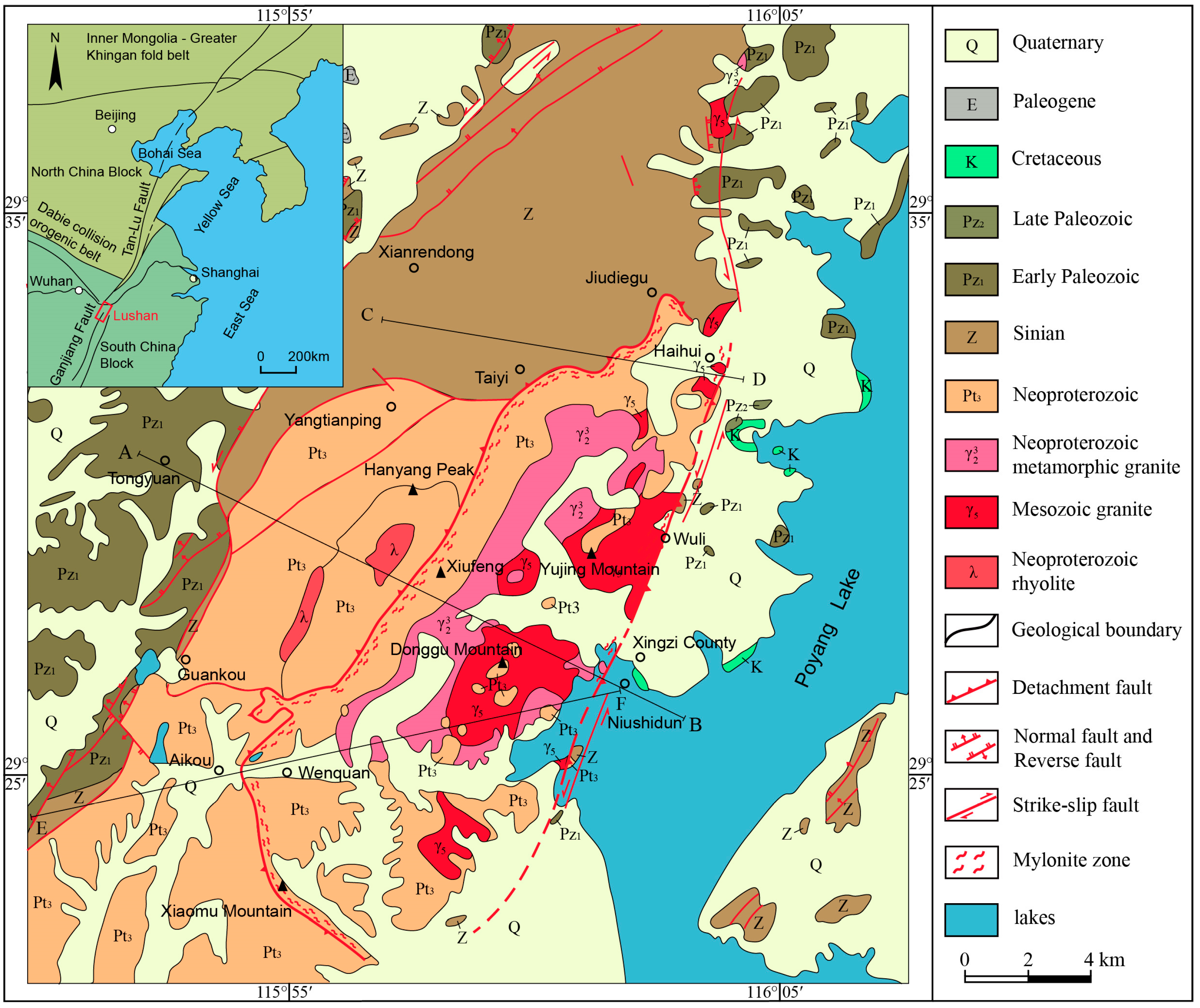
2. Geological Setting

The geographic location of the Lushan area is at the northern border of Jiangxi Province, south of the Yangtze River and west of Poyang Lake. Its geotectonic position is located at the junction of the middle and lower Yangtze on the northeast margin of the Yangtze plate, with the Dabie collision orogenic belt to the north and the Jiangnan uplift to the south (Figure 1). A wide variety of rock types is exposed in the Lushan Massif, including sedimentary rocks, middle–high grade metamorphic rocks, intrusive rocks, and volcanic, which constitute a three-layer structure from the top down, namely the metamorphic basement in the core, detachment fault, and sedimentary cover [44].
According to petrographic composition and metamorphic grade, it is generally acknowledged that the sedimentary cover consists of clastic rocks, volcanic–sedimentary rocks, and epimetamorphic rock series of the Shuangqiaoshan Group, Lushanlong Group, and Guling Group (also known as a ductile rheological layer). The detachment fault consists of mylonite, tectonic schist, and the breccia zone. The metamorphic basement consists of the Xingzi group, Yanshanian granite-intruded Xingzi group, and Precambrian metamorphic granite (Figure 2), and the Xingzi group consists of garnet-bearing mica schists, biotite-garnet-staurolite mica schists, quartzite, and amphibolites, whose protolith was formed in the Neoproterozoic and had undergone amphibolite facies metamorphism [45]. Most of the sedimentary rocks belong to the Late Proterozoic and Paleozoic series except the rare Cretaceous red beds exposed near the Poyang Lake. In the western and northeastern Lushan Massif, the unmetamorphosed early Paleozoic rocks consist of Sinian–Ordovician terrigenous clastic rocks and Cambrian carbonates. In the north, the exposed rocks in the highest peaks of the Lushan area are mainly clastic rocks of Sinian. To the south and east, this stratum is underlain by epimetamorphic volcanic–sedimentary rocks of the Neoproterozoic.
The Lushan Massif preserves the Late Mesozoic two-period structures, namely the early strike-slip tectonic system and the late extensional tectonic system. The early strike-slip tectonic system is represented by the Xingzi shear zone (XZSZ) in the east and the Lianhua shear zone (LHSZ) in the west. In addition, many small strike-slip ductile shear zones and NE trending folds between the two main faulted zones probably formed during the same period. The late extensional tectonic system is represented by the western detachment fault (WDF) and the eastern detachment fault (EDF) of the Lushan Massif.

3. Two Phases of Deformation of the Lushan Massif

3.1. Transpressional Deformation (D1)

3.1.1. Xingzi Shear Zone (XZSZ)

The XZSZ consists of several nearly vertical ductile shear zones with a strike of 30°, which limited the eastern boundary of the Lushan Massif. It is well-exposed in the Niushidun area, Xingzi County (Figure 3A). There is a 5–30 cm width mylonite occurring in the middle of the shear zone with the intensive plastic flow. The edge of the shear zone mainly consists of protomylonite and mylonitic rocks with a width of 10–20 m. The stereographic projection shows that the foliations of rocks in the XZSZ always strike 10–45° and dip 65–90° SE with subhorizontal lineations. Abundant structural traces at different scales, such as rotated feldspar porphyroblasts, S-C fabrics, tectonic lens, and asymmetric fold (Figure 4a,b), all indicate the sinistral shearing. In addition, similar tectonic phenomena can be seen in the Haihui and Wuli areas. Many places of ductile shear zones are cut by later extensional deformation reflected in the cross-cuttings of two episodes of mylonites.

3.1.2. Lianhua Shear Zone (LHSZ)

The LHSZ in the west of the Lushan Massif, which limited the western boundary of the Lushan extensional dome (LSED), is represented by a strike-slip ductile shear zone with a strike of 40° in Lianhuadong (Figure 3B). The nearly 100-m-wide ductile shear zones whose protolith is tuffaceous sandstone or fine sandstone experienced strong ductile deformation and mylonitization. There are large areas with the emergence of a-type folds, asymmetric folds (Figure 4c), and bedding quartz veins in the shear zone, and they all indicate the overall kinematics of sinistral shearing. The foliations of rocks in the LHSZ strike 30–60° and dip 65–85°, and on the surface of foliation, strong horizontal lineation and dip lineation develops, which illustrates the late extensional decollement. On the whole, the LHSZ has a more complete state of preservation and a generally larger scale, while the XZSZ underwent a stronger deformational metamorphic history. The different scale and deformation degree and the similar character may reflect the synchronous tectonic activity in different structural positions.

3.1.3. Other Ductile Strike-Slip Structures

These small sinistral strike-slip ductile shear zones located in the north area of the Lushan Massif always strike 20–55° and dip NW, influenced by the extension of the LSED (Figure 3C). The subhorizontal stretching lineation and down-dip lineation both developed in the shear surfaces are likely related to the two-period tectonic stresses of compression and extension. The two-period structures are mainly exposed in places such as Tiyi village, Ruanjiapeng, and Qicai Waterfall and are characterized by left-lateral normal faults (Figure 4d). Moreover, many fold–thrust belts developed in the Lushan area with an opposite tendency to that of the detachment surfaces and a consistent kinematics of the detachment conjectured to be syntectonic thrust tectonics in an extensional setting. It reflects the kinematics characteristics of strata slipping along different flanks of pre-existing NE-strike folds.

3.2. Extensional Deformation (D2)

The extensional tectonic system of the Lushan Massif is considered to be near east–west symmetrical in structural form and extension direction (Figure 5 and Figure 6). The WDF has been thoroughly studied, while the EDF is a debatable point, and relatively little is known; the latter is a focus of this study.

3.2.1. Identification of the EDF

The extensional tectonic system of the Lushan Massif can be divided into two detachment tectonic belts, namely, the WDF and the EDF. A massive regional work has been underway for the WDF since the early 1990s, while for the EDF, there is a lack of research due to the Quaternary overburden and fault damage, and it is defined for the first time in this paper. Large-scale extension-detachment and ductile rheology are exhumed in the drying zone of Poyang Lake, eastern Lushan, and Xingzi County, and we consider this area the EDF.
Due to vague knowledge about the eastern Lushan area, some scholars drew an analogy between the EDF and the Wuli normal fault which is almost in the same location. After inspections that compared the formation age or fault characteristics, it was found that the Wuli normal fault with the brittle and late-stage features is not the EDF. Lower water levels on Poyang Lake due to the dry season led to the complete exposure of the Niushidun area and other places, and we found large-scale extension detachment and ductile rheology (Figure 7a). The well-developed detachment surface with clear dip lineation strikes 25–83° and dips 20–54° SE. On account of the observation of the SE-dipping EDF, abundant ductile rheology structures, such as feldspar rotating phenocryst, S-C fabric, mica fish (Figure 7b), etc., and fold structures, such as plunging vertical fold (A-type), recumbent fold (Figure 7c), and bending fold consistently indicate top-to-the-SE detachment.
The large-scale low-angle mylonite, tectonic schist, and tectonic gneiss, which were probably moved to the surface by an extension of detachment fault with a large displacement, are the most important components of the rock stratum in this area. The migmatite zone and a series of pegmatite veins and felsic veins are also key parts of the EDF and form a high-strain zone that exhibits well-developed ductile deformation. The irregular veins formed in the process of rapid metasomatism and the penetration of plastic fluid at high temperatures, that is, the veins are considered the solid plastic flow related to dynamic metamorphism, resulting from the intrusion of magmatic hydrothermal fluid along weak tectonic belts during the extension process. Therefore, we believe that the mylonite zone and tectonic schist (or gneiss) zone of the EDF are well-preserved, and other structural layers probably lie concealed beneath Poyang lake. In addition, granitic mylonite exposed in the Wulihe area and mylonitized granite exposed in Haihui are speculated to be affected by the EDF; the EDF is arguably located in these areas.

3.2.2. The WDF

The WDF has an irregular arc distribution around the core of the LSED, with a tendency change of NW–W–SW corresponding to the orientation of northwest-west-southwest, and the occurrence is generally parallel to the foliation of the Xingzi group complex [44,46]. The WDF is poorly developed, but we can still find some clues of detachment in ductile-deformed rocks within the ductile decollement zones. The WDF shows multi-level, multi-strength, and multi-scale features containing the tectonic schist zone, breccia zone (Figure 7d), and migmatite zone, and a solid rheological structural belt is exposed above the WDF. The main detachment surface is characterized by the strongest metamorphic deformation and the biggest sliding distance, and it reflects the feature of significant weakness zoning horizontally and deformation layering vertically. Furthermore, there is still some discrepancy on whether the Lushan Massif is a metamorphic core complex or an extensional dome, and the extremely fragmentary detachment is the principal reason to support the latter view; however, the identification of the EDF, though also incomplete, provides some evidence for the former view. We still call it the Lushan Massif extensional dome because the focus of this paper is on the transition from compression to extension rather than the definition of the Lushan Massif.

4. Zircon U-Pb and Mica Ar-Ar Geochronology

In order to obtain the ages of the Mesozoic compressional and extensional events, U–Pb dating of zircon and Ar–Ar dating of muscovite and biotite were used on ten samples, with three samples from the sinistral strike-slip structures, five samples from the detachments, and two samples from Mesozoic granites. The sample localities are shown in Figure 8.

4.1. Sample Description

Samples LS26-2, LS26-3, and LS1-1 were collected from the early strike-slip structures. The mylonitized granite gneiss (sample LS26-2), collected from the mylonite zone within the XZSZ, shows the well-developed ductile shear deformation reflected in the development of folds, S-C fabrics, NNE-striking stretching lineations, and mylonitic microstructures. Such ductile structures as structural lenticels at the macro-scale and mica fish at the microscopic scale all indicate sinistral shear sense. The biotite plagioclase gneiss (sample LS1-1) was collected from the sinistral brittle–ductile shear zone (outside the scope of Figure 1) that dips to the NWW at angles between 70° and 85°. The nearly 10-m-wide subvertical shear zone, regarded as the Tan–Lu fault, orthogonally cuts E-W trending A-type recumbent fold which is considered an orogenic result controlled by Tethys tectonic regime. Thus, it is the place of the tectonic regime transition from the Tethys tectonic regime to the Pacific tectonic regime.
Samples NS-7, NS-17, NS-16, LS17-2, LS18-1, and LS26-3 were collected from the late extensional structures with samples NS-7, NS-17, NS-16, and LS26-3 from the EDF and samples LS17-2 and LS18-1 from the WDF. The mylonitized pegmatite vein (sample NS-7) of strong deformation, taken from a rootless fold within protomylonite, possesses a massive structure and a granoblastic texture. The occurrence is consistent with that of the mylonitic foliation of protomylonite. Feldspar and quartz grains both show widespread dynamical recrystallization. The veins that developed in the wall rock of the detachment fault, by contrast, usually feature weak deformation and brittle failure, and different occurrences from the detachment fault. The mylonitized felsic vein (sample NS-17) is widely distributed within the tectonic schist, characterized by lenticular or ptygmatic folds connected to the shearing and plastic flow of the detachment fault. The plagioclase phenocryst is large and has clear microfractures with fine-grained quartz and biotite filled in it. Quartz grains show dynamical recrystallization and a characteristic flow structure. Judging from the occurrence and deformation degree, sample NS-17 is a syntectonic vein similar to sample NS-7. The SEE dip biotite plagioclase gneiss (sample NS-16) collected from the palaeosome within the striped migmatite belongs to a part of the detachment fault. Feldspar and quartz grains both show widespread dynamical recrystallization and form core and mantle structures. The directional arrangement of biotite crystals distributed in the edge of plagioclase phenocryst defines a gneissic foliation. The post-tectonic mylonitized felsic vein (sample LS26-3) that could form in the syn-extensional stage occurs in the tectonic schist within the edge of the XZSZ, cuts through the syntectonic vein and the schistosity plane of a tectonic schist with a large-angle. The NW-dipping chlorite schist (sample LS17-2) and the NNW-dipping muscovite–quartzose schist (sample LS18-1) were collected from the hanging wall of the WDF with the development of syntectonic lineation and intrafolial folds. Mylonitization, sericitization, and weak chloritization occur on a large scale, and signs of NE-directed sinistral shearing could be found in the area.
Haihui tonalite (sample LS23-1, LS23-2), which develops in the core of the LSED close to the EDF, is medium-to-coarse grained and has a massive structure, and mainly consists of quartz, plagioclase, and biotite. Quartz and biotite grains underwent plastic deformation and were distorted and elongated to form a 60° strike directional flow. Plagioclase phenocrysts are characterized by pale red potassium alteration. The uplift of the Lushan Massif has close relation with the emplacement of Mesozoic granite, including the Haihui tonalite, and the emplacement age can approximately represent the uplift time.

4.2. Analytical Techniques

4.2.1. Zircon U-Pb

Zircons were separated using standard magnetic and heavy-liquid techniques at Langfang laboratory, Bureau of geology and mineral prospecting and exploitation of Hebei province, and the CL images (Figure 9) were produced at Jinyu Technologies Co Ltd., Chongqing. Zircon U-Pb dating was conducted using a GeoLasPro LA-ICPMS coupled to an ArF 193 nm ultraviolet laser system with a 32-μm-diameter beam spot at the School of Resources and Environmental Engineering, Hefei University of Technology, Hefei. The standard zircon 91500 and SRM 610 were used to calibrate the Pb/U ratio and U concentration [47]. Analyte signals, time-drift corrections, and quantitative calibration of trace element analyses and U-Pb ages were performed using the software ICPMSDataCal 9.0 [48,49], and the measured Pb isotopic compositions were corrected for common Pb using non-radiogenic 204Pb [50]. The results of the zircon U-Pb analysis are listed in Table S1 and were plotted on concordia diagrams (Figure 10) using the Isoplot 3.0 [51] program.

4.2.2. Mica Ar-Ar

The muscovite and biotite samples were crushed and purified with a magnetic separator and cleaned using an ultrasonic treatment, and then were irradiated in the pool-type light–water reactor (49-2 reactor) at the China Institute of Atomic Energy at a neutron flux of 2.65 × 10¹³ n cm−2 S−1. After irradiation, the argon extraction was carried out by incremental heating experiments using an electron-bombardment heated furnace under vacuum, and the heating extraction step for each temperature increment and purification lasted 30 min. Age estimates were obtained by mass spectrometric analysis undertaken using a Helix MC mass spectrometer at the Institute of Geology, Chinese Academy of Geological Sciences. The correction factors of interfering isotopes produced during irradiation were determined by analysis of irradiated pure K2SO4 and CaF2, the values of which are: (36Ar/37Aro)Ca = 0.0002389, (40Ar/39Ar)K = 0.004782, (39Ar/37Aro)Ca = 0.000806. The decay constant λ used is 5.543 × 10⁻¹⁰/year (Steiger and Jäger, 1977). The inverse isochron diagrams are defined by using the Isoplot 3.0 program of Ludwig (2003) [51].

4.3. Analytical Results

4.3.1. U-Pb Dating of Zircon

Zircons from samples NS-7 and NS-17 form dark yellow, semitransparent, columnar, and euhedral to subhedral grains that are 50–300 μm in length, with length–width ratios of 1:1–4:1. CL images reveal that spongy relict zircons are unevenly distributed in the inherited cores, believed to form in intense hydrothermal alteration associated with sinistral shearing. The newly crystallized rims exhibit wide oscillatory zoning, interpreted to have crystallized from metamorphic fluid with the rapid proliferation of trace elements at high temperatures. Seventy-two effective analyses were performed on samples NS-7 and NS-17 in the EDF. Th/U ratios of 56 metamorphic rims range from 0.01–0.14. One analysis yielded the youngest age of 98 Ma, and 55 analyses yielded weighted mean 206Pb/238U ages of 140 ± 1 Ma for NS-7 and 137 ± 2 Ma for NS-17, which are considered the crystallization ages of the metamorphic veins. In contrast, 16 inherited cores with Th/U ratios of 0.01–0.15 yielded older weighted mean 206Pb/238U ages. Two analyses yielded the oldest ages of 185 Ma and 175 Ma, which represent captured zircon ages of the Early Jurassic, and the remaining fourteen analyses yielded weighted mean 206Pb/238U ages of 153 ± 6 Ma for NS-7 and 151 ± 4 Ma for NS-17, which is considered the time of hydrothermal alteration.
Zircons from sample NS-16 can be divided into two types. The majority of zircons are dark yellow, semitransparent, columnar to granular and subhedral, and show low-luminescent features and weak oscillatory zonation, indicative of a metamorphic origin. A few zircons are colorless, transparent, long columnar, and euhedral, and exhibit clear core-rim structures and bright oscillatory zoning, suggestive of a typical magmatic origin. A total of 43 effective analyses were obtained on zircons from sample NS-16, and four analyses were discarded because of strong discordance. Thirty-nine analyses of metamorphic zircons have low Th/U ratios (0.01–0.06) except NO.3. One analysis yielded an age of 177 Ma, which represents the captured zircon age of the Early Jurassic; the remaining thirty-eight analyses are concordant and define a weighted mean age of 139 ± 1 Ma, which is interpreted as the metamorphic age of the biotite plagioclase gneisses, namely, the extensional time of the EDF. In contrast, three analyses of the rims of magmatic zircons have relatively high Th/U ratios (0.23–0.46) and yield older 206Pb/238U ages of 822–738 Ma, and one analysis of the core with a Th/U ratio of 1.21 recorded a 207Pb/206Pb age of 2098 Ma, which is interpreted as inherited.
Zircons from sample LS26-2 are mostly brown, semitransparent, short columnar, and subhedral to xenomorphic, ranging in size from 50 to 300 μm in length, with length-width ratios of 1:1–4:1. The CL images show low-luminescent features and clear core-rim structures without oscillatory zoning. The subrounded rims are speculated to be the metamorphic zircons related to the stronger modification by hydrothermal alteration and preexistent cores, the inherited zircons of the protolith. A total of 37 effective analyses were obtained on zircons from sample LS26-2. Twenty-nine analyses of metamorphic zircon rims with Th/U ratios of 0.02–0.20 form a coherent group and yield a weighted mean 206Pb/238U age of 163 ± 2 Ma, which is interpreted to define the formation age of the mylonitized granite gneiss. Eight analyses of the inherited zircon cores with Th/U ratios of 0.02–0.10 yield a weighted mean 206Pb/238U age of 179 ± 5 Ma, considered as the protolith age of the mylonitized granite gneiss.
Zircons from sample LS26-3 are light yellow, semitransparent, columnar, euhedral to subhedral, and 50–150 μm in length, with length-width ratios of 1:1–2.5:1. In the CL images, zircons commonly show that the inherited cores and the newly crystallized rims form core-rim structures similar to that of samples NS-7 and NS-17. Thirteen analyses of metamorphic zircon rims, with Th/U ratios of 0.02–0.17 except NO.8, yield a weighted mean 206Pb/238U age of 136 ± 2 Ma, which is interpreted as the crystallization age of the post-tectonic felsic vein. One zircon with clear oscillatory zoning exhibits a magmatic origin, with the rim yielding an age of 184 Ma and the core an age of 745 Ma.
Zircons from sample LS23-1 are mostly light yellow, semitransparent, long columnar, and euhedral, ranging in size from 75 to 300 μm in length, with length-width ratios of 1.5:1–4:1. The CL images reveal that zircon grains have well-developed narrow oscillatory zoning, indicative of a typical magmatic origin. Most zircons have no obvious core-rim structures, and few zircons have inherited cores. The U-Pb age data with Th/U ratios of 0.49–1.57 can be divided into two discrete and meaningful age groups. Twenty-eight analyses yield a consistent weighted mean 206Pb/238U age of 131 ± 2 Ma, and the oscillatory zoning and high Th/U ratios of the zircons indicate that the age represents the time of emplacement of tonalite. Two analyses yield a weighted mean 206Pb/238U age of 153 ± 8 Ma, which is considered to represent captured zircon ages of the Late Jurassic corresponding to the ages of the inherited cores of NS-7 and NS-17.

4.3.2. Ar-Ar Dating of Mica

Two muscovite samples (LS17-2, LS18-1) from the WDF and one biotite sample (LS23-2) from the Haihui granite record reliable 40Ar/39Ar ages. Moreover, another biotite sample (LS1-1) from the biotite plagioclase gneiss within the Tan–Lu fault in Sanzu Temple, Anhui province, was also dated in this study.
The age spectra and inverse isochron plots are shown in Figure 11, and the results of the Ar–Ar data are summarized in Table 1. Sample LS17-2 for six heating steps (810–1030 ℃) yields a well-defined plateau age of 114 ± 2 Ma that encompasses 68.44% of cumulative 39Ar released, with an inverse isochron age of 113 ± 4 Ma, consistent with the plateau age within errors (Figure 11a). Sample LS18-1 for eight heating steps (750–1100 ℃) has a well-defined plateau age of 126 ± 1 Ma that contains 100% of cumulative 39Ar released, with the corresponding inverse isochron age of 126 ± 2 Ma (Figure 11b). Samples LS23-2 for six heating steps (750–970 ℃) yields a well-defined plateau age of 95 ± 1 Ma that contains 95.48% of cumulative 39Ar released, with the corresponding inverse isochron age of 96±2 Ma (Figure 11c). Samples LS1-1 for six heating steps (750–1100 ℃) yields a well-defined plateau age of 150 ± 2 Ma that encompasses 98.96% of cumulative 39Ar released, with an inverse isochron age of 153 ± 3 Ma, consistent with the plateau age within errors (Figure 11d).
The age points of four samples are all concentrated at the bottom of inverse isochron due to the similar isotope ratios of the argon released in the mid-high temperature phase and the initial (40Ar/36Ar)0 ratios show a slight deviation from the present day atmospheric value (295.5); this may cause errors in the results, but the inverse isochron ages are consistent with the plateau ages and the total fusion ages, indicating a negligible effect on ages. Thus, the four plateau ages are accepted for later geological interpretation. For the others, the estimates [52] of the deformation temperatures for the detachment of the Lushan Massif by the dynamic recrystallization microstructures of quartz and feldspar are >500 ℃, obviously higher than the closure temperatures for both muscovite and biotite [53,54]. Therefore, the inferred ages represent cooling ages for the dated minerals.

5. Discussion and Interpretation

5.1. Formation Mechanism of the Detachment Fault

From the feature of extension controlling magmatism, we can see that the geometric symmetry of these two detachment faults is not due to magmatic diapirism but probably due to the reconstruction of the original detachment belt. As mentioned above, the extensional time of the EDF is slightly later than that of the WDF, and the dip angles of the EDF are commonly larger than that of the WDF from field observations. More importantly, the residual ductile rheology structures found on the SE-dipping fault plane in eastern Lushan reflect thrusting from SE toward NW [55], while the WDF does not show any evidence of thrusting from NW toward SE. From the foregoing, it is speculated that the west-dipping WDF is the original detachment fault of the Lushan Massif localized between the “hot and soft” lower base and the “cold and hard” upper block, and the initial dip angle is considered to be nearly horizontal [56,57,58,59], while the east-dipping EDF is a secondary detachment fault formed by diapirism and folding from the gravitational equilibrium of crustal thinning, and the original detachment fault has been worn away by intense neotectonic movement in eastern Lushan (Figure 12). In general, the basic form of the detachment fault was mainly controlled by active extension and folding, and strong magmatism played a positive role in advancing and promoting the final form.

5.2. Tectonic Transition from Compression to Extension

5.2.1. Geodynamic Setting

The two-period structures agree with the main trends of NNE-SSW, and the early sinistral strike-slip structures were modified and overlaid with the late LSED (Figure 13), as evidenced by the superposition of subhorizontal stretching lineations and down-dip lineations on the detachment surfaces and the microscopic structure features, including the internal structure of the zircons and the U-Pb isotopic system.
In the Mesozoic, due to the NNW-trending subduction of the Pacific plate towards the Eurasian plate at a low angle, the tectonic patterns of eastern China changed from E-W direction to NE and NNE, indicating the transition from the Tethys tectonic regime to the Pacific tectonic regime. The active ages of 163–151 Ma of NNE trending sinistral ductile strike-slip structures in the Lushan area agree with most previous results in South China, and therefore we could argue that the strike-slip ductile structures are controlled by the Pacific plate subduction and collision. The Lushan Massif, of which the NW-SE trending extension is coincident with the Late Mesozoic regional extension direction of Eastern China, is the product of lithospheric thinning in South China controlled by back-arc extensional settings. The compressional stress transformed into extensional stress correlated with the delamination resulting from the gravitational collapse or the thermal relaxation of the thickened lithosphere root.
Based on structural-magmatic-metallogenetic research in different areas of South China, different evolution models have been put forward, but the series of geological processes including the transition from compression to extension, are quite complicated and difficult to be precisely and completely generalized by any single pattern. Thus, the convergence model of multiple blocks has been proposed to explain the tectonic evolution of South China in recent years [27,60,61]. Moreover, the subduction direction of the Pacific plate dramatically changed to westward forward subduction from the NW-trending oblique subduction in the Late Cretaceous [62,63,64]. From the distribution, stress direction, and active age, the drifting history of the Pacific plate tallies with the major geological events in South China, and the idea that plate interactions during oblique subduction are the main driving forces for the transition of two-period tectonic stresses and other intraplate tectonics in general.

5.2.2. Tectonic Evolution Sequence

In the present study, the zircon U–Pb dating and Ar–Ar dating results provide precise constraints for the two-period structures in the Lushan Massif, and in contrast to the Ar–Ar dating, the zircon U–Pb dating plays a more important role in obtaining the time of transition from regional compressional to extensional settings. The rims of metamorphic zircons from syntectonic veins within the detachment are interpreted to crystallize from metamorphic fluid in an extensional setting. The cores of metamorphic zircons from the detachment and the rims of metamorphic zircons from syntectonic rocks within the strike-slip ductile shear zone are speculated to form in intense hydrothermal alteration associated with dynamic metamorphism fluid, resulting from sinistral shearing. This fact shows that one zircon records two-stage ages of compression and extension, and the rocks in which these zircons were collected also develop two phases of compression and extension deformation from field observations.
The zircon U–Pb dating of rocks from the XZSZ and the EDF revealed that the metamorphic newly produced zircons record extensional ages of 140Ma, 137Ma, 136 Ma, and 139 Ma and the zircons associated with the hydrothermal alteration record strike-slip ages of 163Ma, 153Ma, and 151Ma, basically consistent with the 40Ar/39Ar age of 150 Ma obtained from the Tan–Lu fault and the single zircon U–Pb age of 153 Ma obtained from the Haihui tonalite. During the second generation of Mesozoic sinistral strike-slip of the Tan–Lu fault, a series of NE–NNE trending sinistral wrench faults with the same orientation, property, and time as the Tan–Lu fault formed in eastern China and were named the Tan–Lu fault system [65,66,67]. The NNE trending XZSZ and LHSZ and other ductile strike-slip structures, close to the southern end of the Tan–Lu fault and arranged in sinistral en-echelon with the Tan-Lu fault, are considered to be a part of the Tan–Lu fault system. Both amphibole Ar–Ar dating [68] and muscovite Ar–Ar dating [69] show that the WDF formed earlier than 140 Ma. The plateau ages of 126 Ma and 114 Ma are interpreted as representing cooling during the thermal uplift of the WDF. It also means the extension of the detachment fault started at the range of 150–140 Ma and lasted through at least 114 Ma. Brittle normal faults occurred in the later period of extensional deformation and were superimposed by the sinistral strike-slip movement of the Ganjiang fault, thus often forming left-lateral normal faults. The brittle deformation associated with weak extensional setting is dated to 95 Ma and 98 Ma in this study and 99 Ma and 101 Ma reported by Lin et al. (2000) [68].
In comparison with the short period extension of most extensional domes or metamorphic core complexes in the North China Block in the Mesozoic, the South China Block presents a protracted extension active from 140 to 85 Ma [70,71,72], and a two-stage extension has been recognized in some extensional structures in the South China Block relating to episodic back-arc extension [68,73,74]. The timing and evolution history of the two-stage extension are different, which is related to the tectonic position and deep geological environment. The ages of 95 Ma and 98 Ma are interpreted as the timing of the second stage of extension, but the restarted timing of which is uncertain in this study.
As mentioned, the tectonic evolution sequence (Figure 14) of the Late Mesozoic Lushan area can be summarized: (a) the Lushan area underwent sinistral ductile strike-slipping controlled by compressional stress field within 162–150 Ma; (b) the compressional stress transformed into extensional stress and the main detachment fault began acting within 150–140 Ma; (c) the EDF formed based on the WDF within 140–135 Ma and the extension and uplift stage followed; (d) the timing of the first stage of extension ranged from 140 to 114 Ma; meanwhile, granitic magma intruded within 133–123 Ma, and it is a rapid uplifting period; (e) in the second stage of extension (~95 Ma), ductile extension transformed into brittle extension and it is a balanced uplifting period. That is, the Lushan Massif experienced two cycles of compression-extension in the Late Mesozoic.

6. Conclusions

The Lushan Massif underwent sinistral ductile shearing with NNE trending within 162–150 Ma, controlled by a compressional stress field resulting from the subduction of the Pacific Plate.
The Lushan Massif has been considered an extensional dome, which represents a typical extensional structure in South China, and the EDF was first discovered in this study. The timing of the first stage of the extension of the Lushan Massif ranged from 140 Ma to 114 Ma, and the second stage of extension mainly occurred in the Late Cretaceous.
Isotopic ages reveal the tectonic evolution sequence of the South China Block in the Late Mesozoic. The tectonic transition from compression to extension in the South China Block took place at 150–140 Ma.

Supplementary Materials

The following supporting information can be downloaded at: https://www.mdpi.com/article/10.3390/min12121531/s1, Table S1: Zircon LA-ICP-MS U-Pb data of the rocks from the Lushan area.

Author Contributions

Conceptualization, F.Y. and C.S.; methodology, F.Y.; validation, C.S.; formal analysis, F.Y.; investigation, F.Y., C.S. and S.R.; resources, C.S.; data curation, F.Y. and M.J.; writing—original draft preparation, F.Y.; writing—review and editing, F.Y.; visualization, F.Y.; supervision, C.S.; project administration, C.S.; funding acquisition, F.Y. All authors have read and agreed to the published version of the manuscript.

Funding

This research was funded by the National Natural Science Foundation of China, grant number 41272222.

Data Availability Statement

Not applicable.

Acknowledgments

The authors thank Hailong Li for helping with the fieldwork, and Quanzhong Li for helping with the La-ICP-MS experiment. The authors give special thanks to Daoxuan Wang for his constructive suggestions and comments in writing this review paper.

Conflicts of Interest

The authors declare no conflict of interest.

References

  1. Fan, W.; Menzies, M. Destruction of aged lower lithosphere and accretion of asthenosphere mantle beneath eastern China. Geotecton. Metallog. 1992, 16, 171–180. [Google Scholar]
  2. Wei, W.; Song, C.; Hou, Q.L.; Chen, Y.; Faure, M.; Yan, Q.R.; Liu, Q.; Sun, J.F.; Zhu, H.F. The Late Jurassic extensional event in the central part of the South China Block—Evidence from the Laoshan’ao shear zone and Xiangdong Tungsten deposit (Hunan, SE China). Int. Geol. Rev. 2018, 60, 1644–1664. [Google Scholar] [CrossRef]
  3. Feng, Z.T.; Chu, Y.; Wei, W.; Lin, W.; Xin, G.Y.; Wang, Y.; Qiu, H.B.; Ren, Z.H. Splitting a large pluton by Cretaceous crustal extension: Evolution of the Ziyuan Detachment and crustal thinning of the South China Block. Tectonophysics 2022, 838, 229481. [Google Scholar] [CrossRef]
  4. Xu, S.; Unsworth, M.J.; Hu, X.Y.; Mooney, W.D. Magnetotelluric evidence for asymmetric simple shear extension and lithospheric thinning in South China. J. Geophys. Res. Solid Earth 2019, 124, 104–124. [Google Scholar] [CrossRef] [Green Version]
  5. Li, J.H.; Cawood, P.A.; Ratschbacher, L.; Zhang, Y.Q.; Dong, S.W.; Xin, Y.J.; Yang, H.; Zhang, P.X. Building Southeast China in the late Mesozoic: Insights from alternating episodes of shortening and extension along the Lianhuashan fault zone. Earth-Sci. Rev. 2020, 201, 103056. [Google Scholar] [CrossRef]
  6. Yang, W. Flat mantle reflectors in Eastern China: Possible evidence of lithospheric thinning. Tectonophysics 2003, 369, 219–230. [Google Scholar] [CrossRef]
  7. Chu, Y.; Lin, W.; Faure, M.; Xue, Z.H.; Ji, W.B.; Feng, Z.T. Cretaceous Episodic Extension in the South China Block, East Asia: Evidence from the Yuechengling Massif of Central South China. Tectonics 2019, 38, 3675–3702. [Google Scholar] [CrossRef]
  8. Xu, X.B.; Tang, S.; Lin, S.F. Paleostress inversion of fault-slip data from the Jurassic to Cretaceous Huangshan Basin and implications for the tectonic evolution of southeastern China. J. Geodyn. 2016, 98, 31–52. [Google Scholar] [CrossRef]
  9. Xu, X.B.; Liang, C.H.; Xu, Y.D. Kinematic analysis of fault-slip data in the Nanling Tectonic Belt and Cretaceous to Paleogene tectonic evolution of the Central South China Block. J. Asian Earth Sci. 2021, 221, 104951. [Google Scholar] [CrossRef]
  10. Xu, Y.G. Roles of thermo-mechanic and chemical erosion in continental lithospheric thinning. Bull. Miner. Petrol. Geochem. 1999, 18, 3–7. (In Chinese) [Google Scholar]
  11. Lu, F.X.; Zheng, J.P.; Li, W.P.; Chen, M.H.; Cheng, Z.M. The main evolution pattern of phanerozoic mantle in the eastern China: The “mushroom cloud” model. Earth Sci. Front. 2000, 7, 97–107. [Google Scholar]
  12. Monnerau, M.; Rabinowicz, M.; Arquis, E. Mechanical erosion and reheating of the lithsphere: A numerical model for hoptspot swells. J. Geophys. Res. 1993, 98, 809–823. [Google Scholar] [CrossRef]
  13. Niu, Y.L. Generation and evolution of basaltic magmas: Some basic concepts and a new view on the origin of mesozoic-cenozoic basaltic volcanism in eastern China. Geol. J. China Univ. 2005, 11, 9–46. (In Chinese) [Google Scholar]
  14. Zheng, J.P.; Griffin, W.L.; O’Reilly, S.Y.; Yang, J.S.; Li, T.F.; Zhang, M.; Zhang, R.Y.; Liou, J.G. Mineral Chemistry of Peridotites from Paleozoic, Mesozoic and Cenozoic Lithosphere: Constraints on Mantle Evolution beneath Eastern China. J. Petrol. 2006, 47, 2233–2256. [Google Scholar] [CrossRef]
  15. Li, X.H. Cretaceous magmatism and lithospheric extension in Southeast China. J. Asian Earth Sci. 2000, 18, 293–305. [Google Scholar] [CrossRef]
  16. Li, X.H.; Chen, Z.G.; Liu, D.Y.; Li, W.X. Jurassic gabbro-granite-syenite suites from Southern Jiangxi province, SE China: Age, origin, and tectonic significance. Int. Geol. Rev. 2003, 45, 898–921. [Google Scholar] [CrossRef]
  17. Gao, S.; Zhang, B.R.; Jin, Z.M.; Kern, H.; Luo, T.C.; Zhao, Z.D. How mafic is the lower continental crust? Earth Planet. Sci. Lett. 1998, 161, 101–117. [Google Scholar] [CrossRef]
  18. Wu, F.Y.; Sun, D.Y.; Zhang, G.L.; Ren, X.W. Deep geodynamics of yanshain movement. Geol. J. China Univ. 2000, 6, 379–388. [Google Scholar]
  19. Wu, F.Y.; Ge, W.C.; Sun, D.Y.; Guo, C.L. Discussions on the lithospheric thinning in eastern China. Earth Sci. Front. 2003, 10, 51–60. (In Chinese) [Google Scholar]
  20. Wang, Y.J.; Fan, W.M.; Guo, F.; Peng, T.P.; Li, C.W. Geochemistry of Mesozoic Mafic Rocks Adjacent to the Chenzhou-Linwu fault, South China: Implications for the Lithospheric Boundary between the Yangtze and Cathaysia Blocks. Int. Geol. Rev. 2003, 45, 263–286. [Google Scholar] [CrossRef]
  21. Gao, S.; Rudnick, R.L.; Yuan, H.L.; Liu, X.; Liu, Y.; Ling, W.L.; Ayers, J.C.; Wang, X.C.; Wang, Q.H. Recycling lower continental crust in the North China craton. Nature 2004, 432, 892–897. [Google Scholar] [CrossRef] [PubMed]
  22. Deng, J.F.; Mo, X.X.; Zhao, H.L.; Wu, Z.X.; Su, S.G. A new model for the dynamic evolution of Chinese lithosphere: Continental rootsplume tectonics. Earth Sci. Rev. 2004, 65, 223–275. (In Chinese) [Google Scholar] [CrossRef]
  23. Xie, G.Q.; Hu, R.Z.; Zhao, J.H.; Jiang, G.H. Mantle plume and the relationship between it and Mesozoic large-scale metallogenesis in Southeastern China: A preliminary discussion. Geotecton. Metallog. 2001, 25, 179–186. (In Chinese) [Google Scholar]
  24. Hsü, K.J.; Li, J.L.; Chen, H.H.; Wang, Q.C.; Sun, S.; Sengör, A.M.C. Tectonics of South China: Key to understanding West Pacific geology. Tectonophysics 1990, 183, 9–39. [Google Scholar] [CrossRef]
  25. Jiang, D.S.; Xu, X.S.; Wang, X.J.; Zeng, G.; Chen, A.X.; Huang, B.; Huang, F. Geochemical evidence for the Paleo-Pacific plate subduction at ~125 Ma in Eastern China. Lithos 2021, 398–399, 106259. [Google Scholar] [CrossRef]
  26. Shu, L.S. An analysis of principal features of tectonic evolution in South China Block. Geol. Bull. China 2012, 31, 1035–1053. (In Chinese) [Google Scholar]
  27. Mao, J.R.; Ye, H.M.; Liu, K.; Li, Z.L.; Takahashi, Y.; Zhao, X.L.; Kee, W.S. The Indosinian collision–extension event between the South China Block and the Palaeo-Pacific plate: Evidence from Indosinian alkaline granitic rocks in Dashuang, eastern Zhejiang, South China. Lithos 2013, 172–173, 81–97. [Google Scholar] [CrossRef] [Green Version]
  28. Gong, J.; Chen, Y.J. Evidence of lateral asthenosphere flow beneath the South China craton driven by both Pacific plate subduction and the India–Eurasia continental collision. Terra Nova 2014, 26, 55–63. [Google Scholar] [CrossRef]
  29. Li, S.Z.; Zang, Y.B.; Wang, P.C.; Suo, Y.H.; Li, X.Y.; Liu, X.; Zhou, Z.Z.; Liu, X.G.; Wang, Q. Mesozoic tectonic transition in South China and initiation of Palaeo-Pacific subduction. Earth Sci. Front. 2017, 24, 213–225. (In Chinese) [Google Scholar]
  30. Ji, W.B.; Lin, W.; Faure, M.; Chen, Y.; Chu, Y.; Xue, Z.H. Origin of the Late Jurassic to Early Cretaceous peraluminous granitoids in the northeastern Hunan province (middle Yangtze region), South China: Geodynamic implications for the Paleo-Pacific subduction. J. Asian Earth Sci. 2017, 141, 174–193. [Google Scholar] [CrossRef]
  31. Yan, H.B.; Ding, X.; Ling, M.X.; Li, C.Y.; Harlov, D.E.; Sun, W.D. Three late-Mesozoic fluorite deposit belts in southeast China and links to subduction of the (paleo-) Pacific plate. Ore Geol. Rev. 2021, 129, 103865. [Google Scholar] [CrossRef]
  32. Jia, Z.B.; Chen, H.; Xia, Q.K.; Liu, J.; Zhu, K.Y.; Wang, P.Y.; Markhand, A.H. Influence of the subduction of the Pacific plate on the mantle characteristics of South China: Constraints from the temporal geochemical evolution of the Mesozoic basalts in the Jitai Basin. Lithos 2020, 352–353, 1–13. [Google Scholar] [CrossRef]
  33. Ren, J.; Kensaku, T.; Li, S.; Zhang, J. Late mesozoic and cenozoic rifting and its dynamic setting in Eastern China and adjacent areas. Tectonophysics 2002, 344, 175–205. [Google Scholar] [CrossRef]
  34. Meng, Q.R. What drove late mesozoic extension of the northern China–Mongolia tract? Tectonophysics 2003, 369, 155–174. [Google Scholar] [CrossRef]
  35. Wu, F.Y.; Lin, J.Q.; Wilde, S.A.; Zhang, X.; Yang, J.H. Nature and significance of the Early Cretaceous giant igneous event in eastern China. Earth Planet. Sci. Lett. 2005, 233, 103–119. [Google Scholar] [CrossRef]
  36. Song, C.Z.; Lin, S.F.; Zhou, T.F.; Yan, J.; Ren, S.L.; Li, J.H.; Tu, W.C.; Zhang, Y. Mesozoic tectonic regime transition of the Middle and Lower Reaches of the Yangtze River and its adjacent area. Acta Petrol. Sin. 2010, 26, 2835–2849. (In Chinese) [Google Scholar]
  37. Lin, W.; Ji, W.B.; Faure, M.; Wu, L.; Li, Q.L.; Shi, Y.H.; Scharer, U.; Wang, F.; Wang, Q.C. Early Cretaceous extensional reworking of the Triassic HP–UHP metamorphic orogen in Eastern China. Tectonophysics 2015, 662, 256–270. [Google Scholar] [CrossRef] [Green Version]
  38. Xu, X.B.; Zhang, Y.Q.; Shu, L.S.; Jia, D. LA-ICP-MS U-Pb and 40Ar/39Ar geochronology of the sheared metamorphic rocks in the Wuyishan: Constraints on the timing of Early Paleozoic and Early Mesozoic tectono-thermal events in SE China. Tectonophysics 2011, 501, 71–86. [Google Scholar]
  39. Liu, X.; Fan, H.R.; Santoshi, M.; Hu, F.F.; Yang, K.F.; Li, Q.L.; Yang, Y.H.; Liu, Y.S. Remelting of Neoproterozoic relict volcanic arcs in the Middle Jurassic: Implication for the formation of the Dexing porphyry copper deposit, Southeastern China. Lithos 2012, 150, 85–100. [Google Scholar] [CrossRef]
  40. Wang, G.G.; Ni, P.; Zhao, K.D.; Wang, X.L.; Liu, J.Q.; Jiang, S.Y.; Chen, H. Petrogenesis of the Middle Jurassic Yinshan volcanic-intrusive complex, SE China: Implications for tectonic evolution and Cu-Au mineralization. Lithos 2012, 150, 135–154. [Google Scholar] [CrossRef]
  41. Li, Z.L.; Zhou, J.; Mao, J.R.; Santosh, M.; Yu, M.G.; Li, Y.Q.; Hu, Y.Z.; Langmuir, C.H.; Chen, Z.X.; Cai, X.X.; et al. Zircon U-Pb geochronology and geochemistry of two episodes of granitoids from the northwestern Zhejiang Province, SE China: Implication for magmatic evolution and tectonic transition. Lithos 2013, 179, 334–352. [Google Scholar] [CrossRef]
  42. Mao, J.R.; Li, Z.L.; Ye, H.M. Mesozoic tectono-magmatic activities in South China: Retrospect and prospect. Sci. China Earth Sci. 2014, 57, 2853–2877. (In Chinese) [Google Scholar] [CrossRef]
  43. Li, J.W.; Zhao, X.F.; Zhou, M.F.; Ma, C.Q.; De Souza, Z.S.; Vasconcelos, P.M. Late Mesozoic magmatism from the Daye region, eastern China: U-Pb ages, petrogenesis, and geodynamic implications. Contrib. Miner. Petrol. 2009, 157, 383–409. [Google Scholar] [CrossRef]
  44. Yin, G.S.; Xie, G.G. Extensional structure and the Xingzi metamorphic core complex in the Lushan area. Jiangxi Reg. Geol. China 1996, 8, 17–26. (In Chinese) [Google Scholar]
  45. Tang, H.F.; Liu, C.Q. Trace element geochemistry during metamorphic dehy dration: A case study from the Xingzi Group of Lushan, southeast China. Geochem. J. 2002, 36, 545–561. [Google Scholar] [CrossRef]
  46. Xiang, X.K.; Xu, J.H.; Ma, C.X. Preliminary study on the structure of the metamorphic nucleus complex in Lushan. J. East China Geol. Inst. 1994, 17, 11–17. (In Chinese) [Google Scholar]
  47. Wiedenbeck, M.; Alle, P.; Corfu, F.; Griffin, W.L.; Meier, M.; Oberli, F.; Vonquadt, A.; Roddick, J.C.; Speigel, W. Three natural zircon standards for U–Th–Pb, Lu–Hf, trace-element and REE analyses. Geostand. Newslett 1995, 19, 1–23. [Google Scholar] [CrossRef]
  48. Liu, Y.S.; Gao, S.; Hu, Z.C.; Gao, C.G.; Zong, K.Q.; Wang, D.B. Continental and oceanic crust recycling-induced melt-peridotite interactions in the Trans-North China Orogen: U-Pb dating, Hf isotopes and trace elements in zircons from mantle xenoliths. J. Petrol. 2010, 51, 537–571. [Google Scholar] [CrossRef]
  49. Liu, Y.S.; Hu, Z.C.; Zong, K.Q.; Gao, C.G.; Gao, S.; Xu, J.; Chen, H.H. Reappraisement and refinement of zircon U-Pb isotope and trace element analyses by LA-ICP-MS. Chin. Sci. Bull. 2010, 55, 1535–1546. [Google Scholar] [CrossRef]
  50. Andersen, T. Correction of common lead in U-Pb analyses that do not report 204Pb. Chem. Geol. 2002, 192, 59–79. [Google Scholar] [CrossRef]
  51. Ludwig, K.R. User’s Manual for Isoplot/Ex, Version 3.00, A Geochronological Toolkit for Microsoft Excel; Berkeley Geochronology Center Special Publication: Berkeley, CA, USA, 2003; pp. 1–70. [Google Scholar]
  52. Yang, F.; Song, C.Z.; Ren, S.L.; Li, J.H.; Li, H.L. Metamorphism P-T conditions and active age of the detachment belt in the Lushan metamorphic core complex. Acta Geol. Sin. 2018, 92, 979–992. (In Chinese) [Google Scholar]
  53. Hacker, B.R.; Wang, Q. 40Ar/39Ar geochronology of ultrahigh-pressure metamorphism in central China. Tectonics 1995, 14, 994–1006. [Google Scholar] [CrossRef]
  54. Dunlap, W.J. Neocrystallization of cooling: 40Ar/39Ar ages of white mica of low-grade mylonites. Chem. Geol. 1997, 143, 181–203. [Google Scholar] [CrossRef]
  55. Li, W.X.; Zhou, X.M.; Li, X.H.; Xie, G.G.; Li, J.H. Zircon U-Pb dating of pegmatite from Xingzi metamorphic core complex of Lushan mountain and its geological implication. Earth Sci. 2001, 26, 491–495. (In Chinese) [Google Scholar]
  56. Dokka, R.K. Original dip and subsequent modification of a Cordilleran detachment fault, Mojave extensional belt, California. Geology 1993, 21, 711–714. [Google Scholar] [CrossRef]
  57. Livaccari, R.F.; Geissman, J.W.; Reynolds, S.J. Palaeomagnetic evidence for large-magnitude, low-angle normal faulting in a metamorphic core complex. Nature 1993, 361, 56–59. [Google Scholar] [CrossRef]
  58. Livaccari, R.F.; Geissman, J.W. Large-magnitude extension along metamorphic core complexes of western Arizona and southeastern California: Evaluation with paleomagnetism. Tectonics 2001, 20, 625–648. [Google Scholar] [CrossRef]
  59. Zheng, Y.D.; Wang, T.; Ma, M.B.; Davis, G.A. Maximum effective moment criterion and the origin of low-angle normal faults. J. Struct. Geol. 2004, 26, 271–285. [Google Scholar] [CrossRef]
  60. Wang, Y.J.; Fan, W.M.; Zhang, G.W.; Zhang, Y.H. Phanerozoic tectonics of the South China Block: Key observations and controversies. Gondwana Res. 2013, 23, 1273–1305. [Google Scholar] [CrossRef]
  61. Dong, S.W.; Zhang, Y.Q.; Zhang, F.Q.; Cui, J.J.; Chen, X.H.; Zhang, S.H.; Miao, L.C.; Li, J.H.; Shi, W.; Li, Z.H.; et al. Late Jurassic-Early Cretaceous continental convergence and intracontinental orogenesis in East Asia: A synthesis of the Yanshan Revolution. J. Asian Earth Sci. 2015, 114, 750–770. [Google Scholar] [CrossRef]
  62. Engebretson, D.C.; Cox, A.; Gordon, R.G. Relative Motion Between Oceanic and Continental Plates in the Pacific Basin. Spec. Pap. Geol. Soc. Am. 1985, 206, 1–60. [Google Scholar]
  63. Sun, W.; Ding, X.; Hu, Y.H.; Li, X.H. The golden transformation of the Cretaceous plate subduction in the west Pacific. Earth Planet. Sci. Lett. 2007, 262, 533–542. [Google Scholar] [CrossRef]
  64. Cho, H.; Son, M.; Cheon, Y.; Sohn, Y.K.; Kim, J.S.; Kang, H.C. Evolution of the Late Cretaceous Dadaepo Basin, SE Korea, in response to oblique subduction of the proto-Pacific (Izanagi/Kula) or Pacific plate. Gondwana Res. 2016, 39, 145–164. [Google Scholar] [CrossRef]
  65. Xu, J.W. The Tancheng-Lujiang Wrench Fault System; John Wiley & Sons Ltd.: Chichester, UK, 1993; pp. 17–149. [Google Scholar]
  66. Chough, S.K.; Kwon, S.T.; Ree, J.H.; Choi, D.K. Tectonic and sedimentary evolution of the Korean Peninsula: A review and new view. Earth–Sci. Rev. 2000, 52, 175–235. [Google Scholar] [CrossRef]
  67. Zhang, J.D.; Hao, T.Y.; Dong, S.W.; Chen, X.H.; Cui, J.J.; Yang, X.Y.; Liu, C.Z.; Li, T.J.; Xu, Y.; Huang, S.; et al. The structural and tectonic relationships of the major fault systems of the Tan-Lu fault zone, with a focus on the segments within the North China region. J. Asian Earth Sci. 2015, 110, 85–100. [Google Scholar] [CrossRef] [Green Version]
  68. Lin, W.; Faure, M.; Monié, P.; Schärer, U.; Zhang, L.S.; Sun, Y. Tectonics of SE China: New insights from the Lushan massif (Jiangxi Province). Tectonics 2000, 19, 852–871. [Google Scholar] [CrossRef]
  69. Zhu, Q.B.; Yang, K.G.; Wang, Y. Extensional detachment and magmatism of the Lushan metamorphic core complex: Constraints from 40Ar/39Ar and U-Pb geochronology. Geotecton. Metallog. 2010, 34, 391–401. (In Chinese) [Google Scholar]
  70. Ji, W.B.; Faure, M.; Lin, W.; Chen, Y.; Chu, Y.; Xue, Z.H. Multiple emplacement and exhumation history of the Late Mesozoic Dayunshan-Mufushan Batholith in Southeast China and its tectonic significance: 1. Structural analysis and geochronological constraints. J. Geophys. Res. Solid Earth 2018, 113, 689–710. [Google Scholar] [CrossRef] [Green Version]
  71. Ji, W.B.; Chen, Y.; Chen, K.; Wei, W.; Faure, M.; Lin, W. Multiple emplacement and exhumation history of the Late Mesozoic Dayunshan-Mufushan Batholith in Southeast China and its tectonic significance: 2. Magnetic fabrics and gravity survey. J. Geophys. Res. Solid Earth 2018, 123, 711–731. [Google Scholar] [CrossRef] [Green Version]
  72. Zhu, G.; Xie, C.L.; Chen, W.; Xiang, B.W.; Hu, Z.Q. Evolution of the Hongzhen metamorphic core complex: Evidence for Early Cretaceous extension in the eastern Yangtze craton, eastern China. Geol. Soc. Am. Bull. 2010, 122, 506–516. [Google Scholar] [CrossRef]
  73. Li, J.H.; Zhang, Y.Q.; Dong, S.W.; Johnston, S.T. Cretaceous tectonic evolution of South China: A preliminary synthesis. Earth-Sci. Rev. 2014, 134, 98–136. [Google Scholar] [CrossRef]
  74. Li, J.H.; Shi, W.; Zhang, Y.Q.; Dong, S.W.; Ma, Z.L. Thermal evolution of the Hengshan extensional dome in central South China and its tectonic implications: New insights into low-angle detachment formation. Gondwana Res. 2016, 35, 425–441. [Google Scholar] [CrossRef]
Figure 1. Geological map of the Lushan area (modified from 916 geological party of JiangXi bureau of geology and exploration, 2003).
Minerals 12 01531 g001
Figure 2. Transverse section (“A-B”) and tectonic sections in the north (“C-D”) and south (“E-F”) of the Lushan Massif.
Minerals 12 01531 g002
Figure 3. The planar and linear structural elements in (A) mylonites, measured within the XZSZ area; (B) mylonitic rocks, measured within the LHSZ area; and (C) ductile-deformed rocks, measured within the strike-slip ductile shear zones, north of the Lushan Massif. All the diagrams are equiareal, lower hemisphere Schmidt nets. Stereographic projections show a consistent trend of NE-NNE of ductile strike-slip structures in the Lushan Massif.
Minerals 12 01531 g003
Figure 4. Field and microscopic photographs related to ductile strike-slip structures. “Ss” represents mylonitic foliation, and red arrows represent motion directions in the following figures. (a) Fold boudin that indicates the deformation direction in the XZSZ. (b) Sigma-shape feldspar porphyroblasts and oblique quartz grain shape fabrics indicating shear sense. (c) Asymmetric fold that shows the shear direction in the LHSZ. (d) S-C fabric indicating shear sense.
Minerals 12 01531 g004
Figure 5. Plane (a) and stereoscopic (b) sketch of the Lushan area.
Minerals 12 01531 g005
Figure 6. The planar and linear structural elements of extensional structures in the Lushan Massif. (A) Projection of planar and linear elements in the WDF and other ductile extensional strata (including syntectonic thrust tectonics), measured in the northwestern Lushan Massif, showing a top-to-the-NW shear sense. (B) Projection of planar and linear elements in the WDF and other ductile extensional strata, measured in the southwestern Lushan Massif, showing a top-to-the-SWW shear sense. (C) Projection of planar and linear elements in the EDF and other ductile extensional strata, measured in the southeastern Lushan Massif, indicating a top-to-the-SE shear sense. (D) Projection of planar and linear elements in the EDF and other ductile extensional strata, measured in the northeastern Lushan Massif, indicating a top-to-the-east shear sense. All the diagrams are equiareal, lower hemisphere Schmidt nets.
Minerals 12 01531 g006
Figure 7. Field and microscopic photographs related to extensional structures. “Ss” represents mylonitic foliation, and red arrows represent motion directions in the following figures. (a) Tectonic gneiss zone with abundant ductile shearing phenomena in the EDF. (b) Mica-fish indicating a top-to-the-SE sense of shear. (c) Recumbent fold indicating a top-to-SSE shear sense in the EDF. (d) Tectonic breccias zone indicating a top-to-NWW shear sense in the WDF.
Minerals 12 01531 g007
Figure 8. Geological map of the Lushan area with the isotopic dating results and sample localities (the legend is the same as in Figure 1). White circles indicate the local sampling positions.
Minerals 12 01531 g008
Figure 9. Representative cathodoluminescence (CL) images of zircon grains for the rocks from the Lushan area. Circles indicate analyzed spots of U-Pb dating and zircon U-Pb ages are also shown.
Minerals 12 01531 g009
Figure 10. Zircon U-Pb concordia plots and recalculated weighted mean 206Pb/238U ages for sample LS26-2 (a; newly crystallized rims to the left and inherited cores to the right), sample NS-7 (b; newly crystallized rims to the left and inherited cores to the right), sample NS-17 (c; newly crystallized rims to the left and inherited cores to the right), sample LS26-3 (d), sample NS-16 (e) and sample LS23-1 (f).
Minerals 12 01531 g010
Figure 11. Plateau and inverse isochron Ar–Ar age of muscovite samples (a,b) from the metamorphic rocks within the WDF and biotite samples (c,d) from the Haihui granite and the gneiss within the Tan–Lu fault, respectively.
Minerals 12 01531 g011
Figure 12. Structural evolution diagram of extensional stage.
Minerals 12 01531 g012
Figure 13. Schematic diagram showing the formation and evolution of two-period structures for the Lushan area. (a) Oblique subduction of the Pacific plate resulted in compressional stress field with formation of sinistral shear structures; (b) the compressional stress transformed into extensional stress under lithospheric thinning with the formation of extensional structures; (c) extension detachment and magmation led to the formation and uplift of the LSED.
Minerals 12 01531 g013
Figure 14. Late Mesozoic tectonic evolution sequence of the Lushan Massif.
Minerals 12 01531 g014
Table 1. Ar–Ar stepwise heating data for muscovite and biotite samples.
T40Ar(r)/39Ar(k)40Ar/39Ar37Ar/39Ar36Ar/39Ar40Ar(r) (%)39Ar(k) (%)Age (Ma)±2σ
LS17-2, muscovite, J = 0.0038585, tp = 114 ± 2Ma
750 ℃15.2843 15.5315 0.0687 0.0008 98.40 14.20103.6 1.0
810 ℃17.0664 17.4189 0.0890 0.0012 97.97 23.31115.3 1.1
850 ℃16.8543 17.1123 0.0910 0.0009 98.49 16.65113.9 1.1
890 ℃16.6622 16.9887 0.1226 0.0011 98.07 11.23112.7 1.1
930 ℃16.7065 17.1710 0.1344 0.0016 97.29 7.27113.0 1.1
970 ℃17.0712 17.4879 0.0458 0.0014 97.61 4.60115.4 1.1
1030 ℃17.1368 17.8199 0.2122 0.0024 96.15 5.39115.8 1.2
1090 ℃17.8311 18.1594 0.0827 0.0011 98.19 9.57120.3 1.2
1150 ℃18.5431 18.9096 0.1334 0.0013 98.05 7.59125.0 1.2
1220 ℃8.8784 20.1213 2.1772 0.0387 44.06 0.1960.9 14.2
LS18-1, muscovite, J = 0.0038975, tp = 126 ± 1Ma
750 ℃18.2825 18.4367 0.1018 0.0005 99.16 22.42124.5 1.2
810 ℃18.5480 18.7039 0.0869 0.0005 99.16 31.86126.2 1.2
850 ℃18.6073 18.7520 0.0954 0.0005 99.22 16.84126.6 1.2
890 ℃18.4905 18.7956 0.0547 0.0010 98.37 8.25125.8 1.2
930 ℃18.2512 18.8442 0.0149 0.0020 96.85 3.90124.3 1.3
980 ℃18.6717 19.0520 0.1441 0.0013 97.99 3.41127.0 1.3
1040 ℃18.4606 19.0092 0.0151 0.0018 97.11 5.45125.6 1.3
1100 ℃18.5330 18.9855 0.1389 0.0015 97.61 7.89126.1 1.3
LS23-2, biotite, J = 0.0039567, tp = 95 ± 1Ma
750 ℃13.7225 13.9210 0.0539 0.0007 98.57 34.6095.6 0.9
810 ℃13.7904 13.9852 0.0452 0.0006 98.60 14.9896.1 0.9
850 ℃13.6165 14.0525 0.1206 0.0015 96.89 9.6394.9 1.0
890 ℃13.6098 14.0682 0.0949 0.0016 96.74 10.5994.8 1.0
930 ℃13.7114 14.0360 0.0790 0.0011 97.68 17.6295.5 1.0
970 ℃13.7238 14.2435 0.1181 0.0018 96.34 8.0595.6 1.0
1030 ℃12.7975 14.2967 0.2741 0.0051 89.50 2.6689.3 1.2
1130 ℃12.6159 14.1595 0.6516 0.0054 89.06 1.8788.1 1.5
LS1-1, biotite, J = 0.0039929, tp = 150 ± 2Ma
750 ℃21.6873 21.9054 0.0611 0.0007 99.00 27.83150.2 1.4
800 ℃21.4805 21.7656 0.0352 0.0009 98.69 8.32148.8 1.5
840 ℃21.7771 22.1024 0.0595 0.0011 98.52 8.02150.8 1.8
880 ℃21.7082 21.9364 0.0015 0.0007 98.96 7.95150.3 1.5
920 ℃21.5608 21.9640 0.0995 0.0014 98.16 9.68149.3 1.5
960 ℃21.4296 21.8702 0.0816 0.0015 97.98 10.78148.5 1.5
1000 ℃21.6255 22.0163 0.0434 0.0013 98.22 11.54149.8 1.5
1040 ℃22.1215 22.3006 0.0889 0.0006 99.19 9.06153.1 1.5
1100 ℃21.9309 22.2863 0.0377 0.0012 98.40 5.76151.8 1.5
1400 ℃19.8178 22.1054 0.4854 0.0079 89.62 1.04137.7 3.4
Publisher’s Note: MDPI stays neutral with regard to jurisdictional claims in published maps and institutional affiliations.

