Article

National-Scale Geochemical Baseline of 69 Elements in Laos Stream Sediments

1
Key Laboratory of Geochemical Exploration, Institute of Geophysical and Geochemical Exploration, Langfang 065000, China
2
International Centre on Global-Scale Geochemistry, Langfang 065000, China
3
Collaborative Innovation Center for Exploration of Nonferrous Metal Deposits and Efficient Utilization of Resources by the Province and Ministry, Guilin University of Technology, Guilin 541004, China
4
Ministry of Natural Resources and Environment, Vientiane 01000, Laos
5
Beijing Institute of Geological Survey, Beijing 100195, China
*
Authors to whom correspondence should be addressed.
Minerals 2022, 12(11), 1360; https://doi.org/10.3390/min12111360
Submission received: 2 September 2022 / Revised: 1 October 2022 / Accepted: 24 October 2022 / Published: 26 October 2022
(This article belongs to the Special Issue Critical Metal Minerals)

Abstract

:
Geochemical baselines are crucial to explore mineral resources and monitor environmental changes. This study presents the first Laos geochemical baseline values of 69 elements. The National-scale Geochemical Mapping Project of Lao People’s Democratic Republic conducted comprehensive stream sediment sampling across Laos, yielding 2079 samples collected at 1 sample/100 km2, and 69 elements were analyzed. Based on the results of LGB value, R-mode factor analysis, and scatter plot analysis, this paper analyzes the relationship between the 69 elements and the geological background, mineralization, hypergene processes and human activities in the study area. The median values of element contents related to the average crustal values were: As, B, Br, Cs, Hf, Li, N, Pb, Sb, Zr, and SiO2, >1.3 times; Ba, Be, Cl, Co, Cr, Cu, F, Ga, Mn, Mo, Ni, S, Sc, Sr, Ti, Tl, V, Zn, Eu, Al2O3, Tot.Fe2O3, MgO, CaO, and Na2O, <0.7 times; and Ag, Au, Bi, Cd, Ge, Hg, I, In, Nb, P, Rb, Se, Sn, Ta, Th, U, W, Y, La, Ce, Pr, Nd, Sm, Gd, Tb, Dy, Ho, Er, Tm, Yb, Lu, and K2O, 0.7–1.3 times. R-mode factor analysis based on principal component analysis and varimax rotation showed that they fall into 12 factors related to bedrock, (rare earth, ferrum-group, and major Al2O3 and K2O elements; mineralization–Au, Sb, and As) and farming activities–N, Br, S, and C). This study provides basic geochemical data for many fields, including basic geology, mineral exploration, environmental protection and agricultural production in Laos.

1. Introduction

Geochemical mapping has proven to be a cost-effective exploration method for mineral resources [1,2,3,4,5,6,7,8]. Geochemists from all over the world have carried out a series of studies on sample collection, analysis and testing, map making and other means of geochemical mapping, and achieved essential results. The geochemical mapping method is the most effective method for the rapid exploration and evaluation of mineral resources [1,2,3,4,5,6,7,8,9]. In China, national geochemical mapping has been carried out for more than 40 years [6,7,10,11]. Since 1978, more than 2000 ore deposits have been identified by follow-up exploration within targets delineated by China’s National Geochemical Mapping Project [11,12,13,14]. Geochemical mapping approaches have not only focused on mineral exploration but also on the concerns of the environment, human health, land use, and others. Thus, many elements are being given multipurpose applications. The China Geochemical Baselines (CGB) Project, with the determination of 76 elements carried out from 2008 to 2014 [15] is the only project to meet the requirements for the analysis of 71 chemical elements by the global geochemical baselines [16].
The National-Scale Geochemical Mapping Project in Lao People’s Democratic Republic (PDR) (collectively, NGMPL) was supported financially and technically by China according to the agreement between China and Laos, implemented during 2015–2018. A total of 2079 stream sediment samples were collected at an average density of 1 sample/100 km2 from the entire territory of Laos. In this paper, based on the statistics obtained by NGMPL, the Laos Geochemical Baseline (LGB) values of 69 elements are presented. We further discuss the effects of geological background, mineralization, hypergene processes, and human activities on the concentrations of these 69 elements through a comparison of the average crustal (CA) values [17,18] and CGB [19]. The baseline data are important for the evaluation and development of mineral resources, agriculture, and environment monitoring in Laos. The geochemical background values of 69 elements were compared with the crustal abundance and CGB values. The results show that under the influence of geological background, tectonics, magmatic activity and supergenesis, the results of statistical analysis of elemental parameters and R-type factor analysis have their own characteristics. The enrichment of elements has a good indicative significance for the deposits. The baseline data are of importance for the evaluation and development of mineral resources, agriculture, and environment monitoring in Laos.

2. Geological Background

Laos is located in the north-central part of the south-central Asian peninsula, with 80% of its territory occupied by mountains and the rest by basins and plains. It has a tropical and subtropical monsoon climate, with extremely developed vegetation, strong modern weathering and accumulation, and little bedrock exposure, which limits geological investigations due to inconvenient transportation. The strata exposed in Laos are mainly Paleozoic, followed by the Mesozoic and Cenozoic. The Paleozoic strata are mainly developed in the northern and eastern areas. The Mesozoic strata are mainly composed of Middle and Upper Triassic marine tuffs, sandstones, and siltstones exposed in the Xam Nua area, followed by Jurassic marine deposits in the southern valley. The Eocene strata developed in the northern intermountain valleys, and lignite seams are present; the Quaternary strata are widely distributed in the gullies. Tectonically, Laos belongs to the Indochina plate, which is a complex and unified land mass composed of many small blocks and interconnected zones. It is divided into seven tertiary geotectonic units from west to east (Figure 1): the Jinghong-Sukhothai, Simao-Phitsanulok, Vientiane-Kontum, Truong Son, DienBienPhu-Loei, Sepon-TamKy, and Ailaoshan-Song Ma [20,21,22,23,24,25,26,27,28,29].
The Jinghong-Sukhothai volcanic arc mainly develops Upper Carboniferous-Triassic terrigenous clastic rocks, tuffs and volcanic rocks. The geochemical data of Middle and Lower Triassic volcanic rocks show land margin arc features, and these early strata suffered late folding to form a NE folding zone and are covered by Late Triassic terrigenous sandstone unconformity. The intrusive rocks are mainly Early to Middle Triassic Island Arc and Late Triassic S granites [27]. The Simao-Phitsanulok block mainly consists of the Upper Triassic foreland basin-phase coal-bearing milarite sedimentary and Jurassic-Paleocene red terrestrial clastic rock system. The Upper Triassic-Cretaceous terrestrial salt-bearing red clastic rock system is unconformably overlain by the Carboniferous-Permian terrestrial clastic rock-carbonate rock and volcanic rock system [27,30,31]. The Vientiane-Kontum block is strongly magmatic, with granitic intrusive rock types mainly developed from Precambrian to Mesozoic. Large, rifted overflow basalts developed in Cenozoic, and the Mesozoic basin is mainly a set of Triassic-Paleocene terrestrial salt-bearing red-bedded rock systems. The Mekong fold belt is mainly composed of Paleozoic strata, developing a Cambrian-Silurian shallow metamorphic volcanic-sedimentary rock system. The Kontum block is an ancient land mass, composed of a crystalline basement and cover [27,30,31]. During the formation of the Truong Son block, magmatic activity was exceptionally strong, mainly developing Precambrian intermediate and advanced metamorphic rocks and Ordovician-Cretaceous sedimentary and igneous rocks. The mixed lithified hornblende interspersed with black cloud plagioclase and crystalline gneisses developed in the Yuan Paleogene; the calc-alkaline volcanic-intrusive rocks of Devonian-Carboniferous active land margin-island arc type and granites of Early-Middle Permian collisional orogeny and Late Carboniferous-Permian are mainly developed in the Phanerozoic. Carbonatite-land-derived clastic sedimentary rock systems and island-arc calc-alkaline volcanic rock systems such as basalt and andesite [27,32]. The DienBienPhu-Loei suture is composed of metamorphic peridotites, mafic rocks, basal lava and radiolarian siliciclastic rocks from bottom to top. In Laos, ultramafic rocks are only found in the intersection of the DienBienPhu Fracture Zone and the Nam Kham Valley in Luang Prabang East [27,30,31]. The Sepon-TamKy suture is distributed in a north-western direction, and the serpentine green mixed rock assemblage represented by ultramafic, magnesian and terrestrial clastic rocks is exposed. The serpentine green mixed rock bodies are exposed intermittently along the suture zone in the form of tectonic lenses owing to late strong tectonic deformation [27,32]. A relatively complete ophiolite sequence is developed in the Ailaoshan-Song Ma procedure, with metamorphic peridotite, stacked crystal miscellaneous rocks, basal lava, and radiolarian-bearing siliciciclastic rocks from the bottom to the top in order [27,30,33]. The magma belts are mostly located in subduction zones, collision zones, and other areas of strong plate tectonic activity, forming tectonic magma belts with geotectonic significance. These tectonic magma belts are closely related to the formation of mineral resources in the region.

3. Materials and Methods

3.1. Sampling

Sampling for the NGMPL took place during the period of 2015–2018. The sampling densities of geochemical mapping were dependent on the map scale. The guideline used for determining the sampling density in a geochemical mapping project was based on the map scale, along with the following criteria: each square-centimeter area should have at least one datum on the map. For example, in a geochemical map generated at a 1:1,000,000 scale, each 1 cm × 1 cm area in the map is equal to one 10 km × 10 km field sampling cell. For GPS convenience and sample management, one sample will be taken from each 1:25,000 map sheet, i.e., each sampling cell is 7.5′ (long.) by 5.0′ (lat.), approximately 100 km2 (Figure 2a). The guidelines used for designing the sampling layout were as follows: (1) sampling sites should be distributed as evenly as possible throughout the survey area; (2) each sample site should be at only one position, thereby allowing control of the maximum area of a sampling cell (Figure 2b).
The preference for sampling media was stream sediment, thus active stream sediment samples were taken at the riverbed surface at a depth range of 0–25 cm (excluding materials from the organic layer where present) in hilly and mountainous terrains. Regoliths or soils were the preferred sampling media from the top layer of soil horizon B, usually at a depth of 20–40 cm in plain terrains. The grain size of the samples was determined to be −10 mesh (2 mm), which can delineate the geochemical anomalies of key ore-prospecting elements [17]. Samples were sieved through −10 mesh on-site or in field camps after natural drying. In total, 2079 samples (including ~5% field duplicates) were collected during the NGML project (Figure 3).

3.2. Laboratory Chemical Analysis

The raw samples were dried in an oven at 45 °C in the laboratory. An 80 g sample was weighed and ground in an agate ball mill to a −200 mesh. The samples were analyzed for 69 elements using ICP-OES, ICP-MS, and XRF in combination with other methods: ICP-OES for seven elements (CaO, MgO, Na2O, Be, Li, Mn, and Sr); ICP-MS for 29 elements (Bi, Cd, Cs, Hf, In, Mo, Pb, Sc, Ta, Te, Th, Tl, U, W, La, Y, Ce, Dy, Er, Eu, Gd, Ho, Lu, Nd, Pr, Sm, Tb, Tm, and Yb); XRF for 20 elements (SiO2, Al2O3, Tot. Fe2O3, KO2, Ba, Br, Cl, Co, Cr, Cu, Ga, Nb, Ni, P, Rb, S, Ti, V, Zn, and Zr); AFS for five elements (As, Hg, Sb, Se, and Ge); ES for Ag, B, and Sn; ISE for F; and GF-AAS for trace gold (Table 1 and Table 2) [34]. Analytical accuracy and precision for laboratory quality were strictly controlled by laboratory replicate samples and standard reference materials [15].

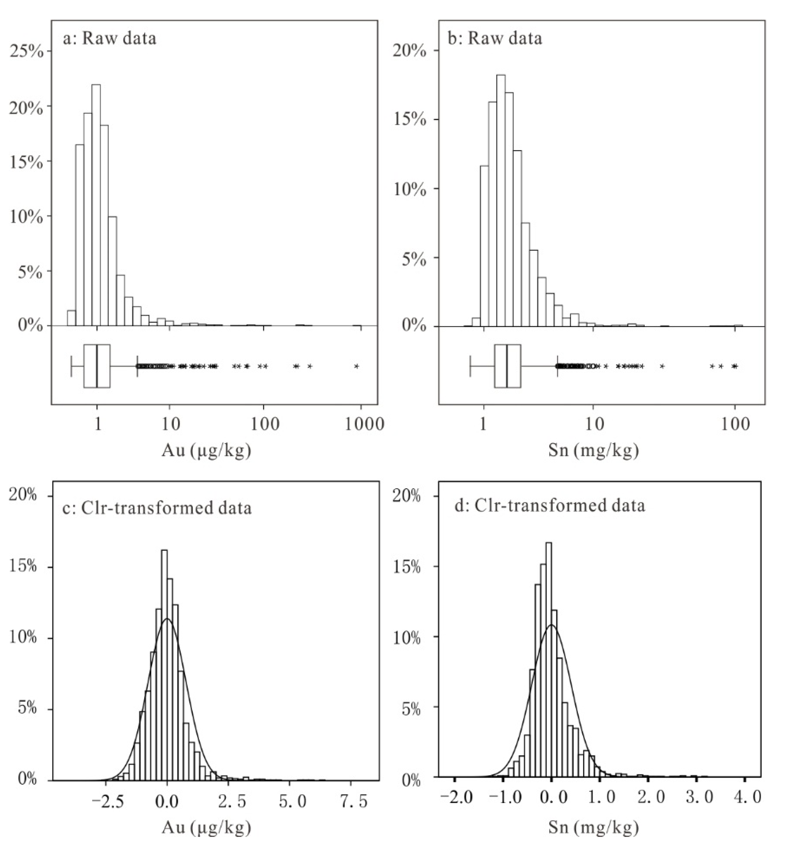
3.3. R-Mode Factor Analysis

Factor analysis is a statistical technique of data reduction used to explain the correlations between observed variables in terms of a smaller number of unobserved variables called factors [35,36,37]. In this study, an R-mode factor analysis, based on principal component analysis and varimax rotation, was performed on the database (n = 2079) to evaluate relationships among all the elements, and factors with eigenvalues >1 were extracted. Prior to the factor analysis, the BDL values were replaced with 0.5 of the detection limits. The centered log-ratio (clr) transformation proposed by Aitchison [38] was performed on the raw data using the CoDaPack [39,40], which is widely used for processing compositional data [41,42,43]. In addition, the clr-transformed data, rather than the raw data, was normally distributed and it satisfied the preconditions for factor analysis (Figure 4a–d).

4. Results

The concept of geochemical background, which originally emerged in exploration geochemistry [44,45,46], generally represents the average value in the natural levels (i.e., not affected by human activities). There are numerous ways to express background concentrations, e.g., arithmetic mean (AM), GM, median, upper confidence limit (UCL) of the mean, upper baseline concentration (UBC), and nth percentile [47]. However, the related soils or sediments are no longer “natural”, given that human-induced changes have historically occurred owing to agriculture and industry. A baseline is used when measuring present levels so that future changes can be recognized or quantified. The establishment of baseline values of chemical elements in soils or sediments is a critical issue [19,45]; as Zoback [48] states, “How do we recognize and understand changes in natural systems if we do not understand the range of baseline levels?” Laos is dominated by agriculture, but not much by modern industry. Therefore, the background is less affected by industry and human activities. The background is used in the context of measuring levels so that any future changes can be quantified. In this study, the median value was accepted as the LGB values of the 69 elements in the stream sediments collected in Laos because the median value is the most robust statistical value of the median trend [19,49].
Table 3 presents the statistical results. The LGB values of As, B, Br, Cs, Hf, Li, N, Pb, Sb, Zr, and SiO2 are 1.3 times the average crustal values [17]. Ba, Be, Cl, Co, Cr, Cu, F, Ga, Mn, Mo, Ni, S, Sc, Sr, Ti, Tl, V, Zn, Eu, Al2O3, Tot. Fe2O3, MgO, CaO, and Na2O are less than 0.7 times the average crustal values.
Further, the LGB values of Ag, Au, Bi, Cd, Ge, Hg, I, In, Nb, P, Rb, Se, Sn, Ta, Th, U, W, Y, La, Ce, Pr, Nd, Sm, Gd, Tb, Dy, Ho, Er, Tm, Yb, Lu, and K2O are 0.7–1.3 times of the average crustal values (Table 4 and Figure 5).
The LGB values of As, B, Br, Cs, Hf, Hg, I, N, Sb, Se, Sn, and W are 1.3 times of the CGB values [17], while that of Ba, Cl, Co, Cr, Cu, F, Ga, Mn, Ni, P, S, Sc, Sr, Te, V, Zn, La, Ce, Pr, Nd, Sm, Eu, Al2O3, Tot. Fe2O3, MgO, CaO, Na2O, and K2O are 0.3 times of the CGB values. The CGB values of Ag, Au, Be, Bi, Cd, Ge, In, Li, Mo, Nb, Pb, Rb, Ta, Th, Ti, Tl, U, Zr, Y, Gd, Tb, Dy, Ho, Er, Tm, Yb, Lu, SiO2, and C are 0.7–1.3 times of the CGB values [19] (Table 4 and Figure 5). Kaiser–Meyer–Olkin (KMO) and Bartlett’s sphericity tests were adopted to evaluate the adequacy of the data set for factor analysis. A KMO value of 0.927 (greater than the recommended minimum value of 0.5) and the significance of Bartlett’s sphericity test (x2 = 271,391.511, p = 0.000) indicate the effectiveness of factor analysis and correlations among the variables. The factor analysis showed that the 69 elements fell into 12 factors explaining 77.93 % of the total variability (Table 5). Factor 1 explaining the largest proportion (11.02 %) of total variability, consists of positive loadings (Bi, Th, U, W, Cs, K2O, Rb, and Tl), which indicate potassium salt deposits and negative loadings (V, Cr, Cu, Ni, Co, Ti, and Tot. Fe2O3), which indicate the weathering of basic volcanic rocks. Factor 2 (accounting for 8.83 % of the variance) consists of positive loadings (Er, Tm, Ho, Yb, Lu, Y, Dy, Tb, and Gd), which indicate bedrocks rich in heavy rare earth. Factor 3 (accounting for 6.55 % of the variance) consists of positive loadings (SiO2, Ge, Cl, Ag, and Zr), which indicate Ag-related mineralization. Factor 4 (accounting for 5.54 % of the variance) consists of positive loadings (La, Ce, Pr, Nd, Sm, and Gd), which indicate bedrock rich in light rare earth. Factor 5 (accounting for 5.07 % of the variance) consists of positive loadings (TC, N, S, Br, I, and Se), which may be related to farming activities. Factor 6 (accounting for 3.15% of the total variance) consists of positive loadings (Sr and Na2O), which may be related to biogenic products and depositional conditions besides source rock characteristics [50,51]. Factor 7 (Ta-Nb association) and Factor 8 (Li-B association), accounting for 3.14% and 2.91% of the total variance, respectively, indicate their highly similar geochemical behaviors. Factor 9 (Sb-As association), accounting for 2.34% of the total variance, indicates hydrothermal activities and possibly serves as an indicator of mineral exploration. Factor 10 (Al2O3), accounting for 2.24% of the total variance, indicates Al2O3-rich areas caused by strong weathering. Factor 11 (Mo) and Factor 12 (Au), accounting for 1.57% and 1.14% of the total variance, respectively, indicate Mo- and Au-related mineralization, respectively.

5. Discussion

5.1. Elements Related to Bedrock

The enrichment/depletion coefficients of the major elements are ranked as follows: SiO2 > K2O > Al2O3 > TFe2O3 > MgO > Na2O > CaO (Table 3 and Figure 5). The concentrations of major elements are controlled by both bedrock and weathering processes. All the major elements of SiO2 in stream sediments were enriched, whereas CaO was significantly depleted. SiO2 content in stream sediment shows a pronounced variability from 12.07 to 94.34%, with a median of 76.43%, which is related to the bedrock geology (sandstone, granite, granodiorite and their metamorphosed equivalents), and also to quartz-rich superficial deposits. Zhu [23] reported a large area of Mesozoic sandstone in northwestern and southern Laos, and a major granite area in northern Laos. The enrichment of SiO2 is related to the residue of quartz-rich sand (while the other elements are leached and bedrocks of sandstone and granites). During the supergenesis of heavy precipitation with an average annual precipitation of 3700 mm in the subtropical region, Ca, Mg, and Na leached, and the median values were significantly lower than that of the crustal abundance. The significantly depleted CaO value when compared with the average crustal and CGB value is contributed by the dissolution of carbonate minerals. The median value of Al2O3 is 10.21% with a range of 0.55% to 27.72%. The enrichment of Al2O3 is mainly caused by the weathering of carbonate and basaltic rocks. Bauxite deposits were reported by Zhu [23] mainly distributed in the Boloven Plateau, which is located in southern Laos. The mining area is of high temperature and rainy, the physical weathering of the source layer, especially the chemical weathering and biological weathering, is very strong, the plateau topography is gentle, there is no fault fold in the area, the structure is simple, suitable for the formation of bauxite. It is known that bauxite belongs to Lateritic bauxite. It is a high-quality lateritic gibbsite bauxite deposit formed in a low-lying area after basalt weathering.
There is a negative correlation between the Rb-K2O-Tl-Cs-Th-Be-Ba-U-W association and the V-Cr-Cu-Ni-Co-Ti-TFe2O3 association in Factor 1 (Figure 6). The V-Cr-Cu-Ni-Co-Ti-TFe2O3 association represents the weathering of basic volcanic rocks, which were originally depleted in Bi, Th, U, W, Cs, K2O, Rb, and Tl; weathering further leaches these elements from the basic volcanic rocks. However, the potassium salt deposits are strongly depleted in V, Cr, Cu, Ni, Co, Ti, and TFe2O3 and enriched in Bi, Th, U, W, Cs, K2O, Rb, and Tl [52,53].

5.2. Rare Earth Elements

The baseline values of rare earth elements (REEs) (La, Ce, Pr, Nd, Sm, Eu, Gd, Tb, Dy, Ho, Er, Tm, Yb, Lu, and Y) are generally consistent with the average crustal values (Table 3 and Figure 5). The REEs exhibit light rare earth element (LREE) enrichment and heavy rare earth element (HREE) depletion, with a negative Eu anomaly curve. The distribution pattern is similar to that of the CGBs with LREE enrichment, flat HREE distributions, and a negative Eu anomaly (Figure 7). The negative Eu anomaly may be due to the leaching of Eu with Ca, in which CaO is significantly depleted in the stream sediments mentioned above; the isomorphism of Eu and Ca exists when the Eu valence state is +2. The results of the factor analysis are consistent with the REE patterns. The LREEs (La, Ce, Pr, Nd, and Sm) and HREEs (Tb, Dy, Ho, Er, Tm, Yb, Lu, and Y) belong to Factors 4 and 2, respectively; Gd belongs to factors 2 and 4, because the loadings of Gd in both factors 2 and 4 are high, 0.62 and 0.71, respectively; and Eu does not belong to any factor (Figure 8).
The low concentrations of REEs in stream sediments are caused by quartz dilution as well as REEs activation during warm and wet weathering [55,57,58,59]. The ratio of LREEs to HREEs is consistent with that of the average crustal value and slightly lower than that of the CGB value (Table 6).
In tropical terrains, the ions absorbed into clays tend to feature more HREEs than LREEs [60]. Thus, HREEs account for a higher percentage of REEs in Laos’ tropical zone than in China’s temperate and subtropical zones. The areas with high concentrations of REEs are in the north on the border between China and Laos, which is consistent with new anomalies delineated and ion-adsorption type REE deposits discovered in Yunnan Province, China [60,61]. This extension of the rare earth metallogenic belt may host ion-adsorption type REEs deposits that are distributed along the Truong Son-Da Nang fault, and the spatial distribution correlates with the granite distribution in the Truong Son block and its intersection area with the Sepon–TamKy suture zone. These findings hold promise for the subsequent exploration of rare earth minerals in Laos.

5.3. Elements Related to Mineralization

Au and Sn are the most important mineral commodities in Laos. The baselines of Au (1.04 μg/kg) are lower than the average crustal values (1.3 μg/kg) (Table 3 and Figure 5). It seems that the depletion of Au is not consistent with the rich gold deposits of Laos. The histogram graph (Figure 4a,b) shows that gold had abnormal distributions, and the boxplots indicate a certain number of samples distributed over Q75, which implies that the high concentrations of gold may be related to gold mineralization. The R-mode factor analysis indicated that Au was represented only in Factor 12, suggesting the absence of significant correlations between Au and other elements (Table 5 and Figure 9). Gold deposits are widely distributed in Laos and are mainly of alluvial, porphyry, quartz vein, and Carlin types. Residual and alluvial-flood gold deposits are the most numerous and widely distributed in Laos. Alluvial gold deposits are mainly concentrated in northern Louangphrabang, the southwest border including Thailand, and the area of Ban Thong kha in the central part of the country. Most of the rivers eroded the pre-Mesozoic metamorphic strata intruded by Mesozoic rocks, and the gold may be associated with the gold- bearing quartz veins in the metamorphic rocks [7,23,26,29,62]. Elemental compositions of different types of gold deposits are quite distinct, and even elemental composition of the same type of gold ore deposits may have a large difference; hydrothermal gold deposits may have high concentrations of volatile elements and metal sulfides, while alluvial-flood gold deposits may have high concentrations of platinum group elements and heavy minerals [63,64,65,66,67,68,69,70]. In addition, Au is highly active in supergene environments. Gold in primary Au deposits can experience mobilization, migration, and reprecipitation under the action of physical, chemical, and biogeochemical processes [71,72,73,74,75]. The diversity of gold ore types and the complexity of metallogenic processes in Laos, and the high mobility of gold in supergene environments indicate no obvious correlation between gold and other elements.
The high concentrations of Sn are highly consistent with the distribution of tin deposits in Laos. The Nam Pathene tin-high concentration area in Khammuane province is the largest tin mine-producing area in Laos [29] and the mine is located in the Nam Pathene area, tectonically at the intersection of the Truong son block and the Sepon–TamKy suture, extending the Truong son–Da Nang fault [23]. The types of tin ore deposits are predominantly alluvial, followed by skarn and hydrothermal.
The study shows that intense hydrothermal activities play an important role in the formation of minerals such as Cu, Pb, and Zn [76]. However, the factor analysis failed to characterize the significance of these elements; Pb, Zn, and Sn were absent from all the factors which may be caused by the complexity of the metallogenic process and bedrocks, and the significant differences in their geochemical behaviors in the supergene environment. (Table 5 and Figure 10). Wang et al.’s [77] study shows that Cu in Laos is unevenly distributed; generally, it is high in the north and low in the south. Most of the copper deposits in Laos are skarn-type, hydrothermal or porphyry types, which are mainly controlled by magmatic hydrothermal and tectonic conditions [25,78]. Most of the Pb-Zc deposits belong to the hydrothermal type, which was formed chiefly during the Late Mesozoic period [76].
The factor analysis results showed mineralization-related element assemblages (Factor 9: Sb-As association). The baseline values of Sb and As (0.5 and 4.9 mg/kg, respectively) were much higher than the average crustal values (RCC > 1.3); they were significantly enriched. Higher As concentrations (>11.7 mg/kg) are mostly influenced by lithology, mineralization, mining, and smelting activities. The study of [79,80] showed that As could be derived from pyrite. Zhu [23] reported a large area of contact with metasomatic and hydrothermal iron deposits in northern and central Laos. Pyrite and other metal sulfides are unevenly distributed in some ores. High concentrations of Sb (1.23 mg/kg) in stream sediment occur with Au-Cu-Sn-Sb-Pb mineralization. The richest Sb occurs in the Nam Paten tin deposit area with 1285 mg/kg of Sb [29]. The enrichment of Sb and As in stream sediments can be an indicator of tin mineral deposits.

5.4. Elements Impacted by Human Activities

The elements C, N, P, and toxic metals, such as Hg and Cd, were found to be easily impacted by human activities. The median of N (411 mg/kg) was much higher than the average crustal value (56 mg/kg) with the most significant enrichment. Figure 11a represents the correlation between N and C. The scatter diagram indicates that most of the N and C samples fall in the same field of farming activities and a small proportion of samples in the field demonstrate a good correlation with CaO (Figure 11d), which is contributed by the limestone composition of calcite minerals (CaCO3). Phosphorus has a good correlation with N and C, indicating that the concentration of N, C, and P are mainly impacted by human activities [53,81] (Figure 11b,c).
The baseline value of Hg (29.1 μg/kg) is basically consistent with the average crustal value (30.0 μg/kg). High concentrations of Hg (>67.8 μg/kg) are mainly distributed in northern Laos as a result of gold mining activities that use Hg to extract Au (reference) [29]. There is a long history of gold mining and processing in Laos, which has caused Hg pollution in the Mekong River and its tributaries and has added a certain degree to the Hg concentration in the surrounding environment [20,82]. The enriched concentrations of mercury are also related to Au, Cu, Pb-Zn, and other minerals along the Louangphrabang, Nam Beng Truong, and Son-Da Nang faults [83].

5.5. Halogen Elements Linked to Climate

The coefficient values of the halogen elements are ranked as follows (Table 3 and Figure 5): Br > I > F > Cl. The baseline value of Br (1.5 mg/kg) is higher than the average crustal value (0.88 mg/kg). The diagram represents a positive correlation between Br and C (Figure 12 and Figure 13).
The enrichment of Br may be linked to absorption by organic carbon in soils or sediments. The baseline value of I (0.7 mg/kg) is consistent with the average crustal value (0.7 mg/kg). However, the baseline values of F and Cl (271 and 61 mg/kg) were lower than the average crustal values. Br was significantly enriched, whereas Cl was significantly depleted. The natural sources of F in the environment are mainly the weathering of fluoride-bearing minerals [84]. A variety of low-temperature hydrothermal deposits have been developed in areas with high F concentrations (>441 mg/kg). There are sedimentary metamorphic coal mines in the area, and the F concentration in coal, claystone, and other rocks (biotite) in the region is generally high [52,83,85,86,87]. However, Laos has abundant rainfall and a high-density network of rivers, and F and Cl are easily leached and transported with drainage water [88]. Therefore, the F and Cl concentrations throughout Laos were well below the average crustal values.
The main limitation of this study is that it focused only on the baseline values of the 69 elements and did not consider their spatial distribution. Therefore, it is essential to describe the spatial distribution of the 69 elements in future research.

6. Conclusions

The NGMPL, which covered the entire national territorial area of Laos for sediment sampling and conducted laboratory chemical analyses of 69 elements, has provided high-quality geochemical baseline data. The LGB values of 69 elements obtained from the NGMPL indicate that the medians of Ag, Au, Bi, Cd, Ge, Hg, I, In, Nb, P, Rb, Se, Sn, Ta, Th, U, W, Y, La, Ce, Pr, Nd, Sm, Gd, Tb, Dy, Ho, Er, Tm, Yb, Lu, and K2O are consistent with the average crustal values; As, B, Br, Cs, Hf, Li, N, Pb, Sb, Zr, and SiO2 are enriched, while Ba, Be, Cl, Co, Cr, Cu, F, Ga, Mn, Mo, Ni, S, Sc, Sr, Ti, Tl, V, Zn, Eu, Al2O3, Tot. Fe2O3, MgO, CaO, and Na2O are depleted. Factor analysis shows that the 69 elements can be divided into 12 factors. The origin and enrichment/depletion of elements in different factors related to bedrock (rare earth elements, ferrum-group elements, and the major elements), mineralization (Au, Sb, As, etc.), and farming activities (N, Br, S, and C) are discussed in the context of geological background, mineralization, hypergene processes, and human activities.

Author Contributions

Writing—original draft preparation, W.W.; writing—review & editing, methodology, X.W. and X.C.; project administration, B.Z.; formal analysis, Q.W.; collected the samples, D.L., Z.H., H.L., J.Z. and L.N.; supervision, S.L. and P.S. All authors have read and agreed to the published version of the manuscript.

Funding

This research was funded the State Key Research & Development Project (2016YFC0600600), China Geological Survey Project (DD20221807, DD20190450), and National Nonprofit Institute Research Grant of IGGE (AS2022P03).

Acknowledgments

We are grateful to all participants of the National-scale Geochemical Mapping Project of Lao PDR (NGMPL) for their hard work in field sampling, laboratory analysis, and data processing. We thank Qing-hua Chi for his valuable suggestions on this work. Constructive comments and suggestions from editors and two anonymous reviewers made this paper more readable and robust.

Conflicts of Interest

The authors declare no conflict of interest.

References

  1. Ottesen, R.T.; Bogen, J.; Bølviken, B.; Volden, T. Overbank sediment: A representative sample medium for regional geochemical mapping. J. Geochem. Explor. 1989, 32, 257–277. [Google Scholar] [CrossRef]
  2. Bölviken, B.; Bogen, J.; Demtriades, A.; De, V.W.; Eeeing, J.; Hindel, R.; Langedal, M.; Locutura, J.; O’Connor, P.; Ottesen, R.T.; et al. Regional geochemical mapping of Western Europe towards the year 2000. J. Geochem. Explor. 1996, 56, 141–166. [Google Scholar] [CrossRef]
  3. Elsenbroek, J.H.; Neser, J.A. An environmental application of regional geochemical mapping in understanding enzootic geophagia of calves in the Reivilo area, South Africa. Environ. Geochem. Health 2002, 24, 159–181. [Google Scholar] [CrossRef]
  4. Wang, X.Q. Exploration geochemistry: Past achievements and future challenges. Earth Sci. Front. 2003, 10, 239–248. [Google Scholar]
  5. Ohta, A.; Imai, N.; Terashima, S.; Tachibana, Y. Application of multi-element statistical analysis for regional geochemical mapping in Central Japan. Appl. Geochem. 2005, 20, 1017–1037. [Google Scholar] [CrossRef]
  6. Xie, X. Development of geochemical mapping. Geol. Bull. China 2008, 27, 163–168. [Google Scholar]
  7. Wang, X.Q. Landmark events of exploration geochemistry in the past 80 years. Geol. China 2013, 40, 322–330. [Google Scholar]
  8. Cheng, Z.; Xie, X.; Yao, W.; Feng, J.; Zhang, Q.; Fang, J. Multi-element geochemical mapping in Southern China. J. Geochem. Explor. 2014, 139, 183–192. [Google Scholar] [CrossRef] [Green Version]
  9. Lado, L.R.; Hengl, T.; Reuter, H.I. Heavy metals in European soils: A geostatistical analysis of the FOREGS Geochemical database. Geoderma 2008, 148, 189–199. [Google Scholar] [CrossRef]
  10. Xie, X. Global geochemical mapping. Geol. China 2003, 30, 1–9. [Google Scholar]
  11. Xie, X. Exploration geochemistry: Retrospect and prospect. Geol. Prospect. 2002, 38, 1–9. [Google Scholar]
  12. Xie, X. Field Method of Regional Geological Survey; Geological Publishing House: Beijing, China, 1979; pp. 4–10. [Google Scholar]
  13. Xie, X.; Ren, T.X.; Xi, X.H.; Zhang, L.S. The implementation of The Regional Geochemistry-National Reconnaissance Program (RGNR) in China in the past thirty years. Acta Geol. Sin. 2009, 30, 700–716. [Google Scholar]
  14. Wang, X.Q. The initiative for international cooperation project of mapping chemical earth for sustaining global resources and environments. Geol. China 2017, 44, 201–202. [Google Scholar]
  15. Wang, X.; The CGB Sampling Team. China geochemical baselines: Sampling methodology. J. Geochem. Explor. 2015, 154, 17–31. [Google Scholar] [CrossRef]
  16. Darnley, A.; Björklund, A.; Bölviken, B.; Gustavsson, N.; Koval, P.; Plant, J.; Steenfelt, A.; Tauchid, M.; Xuejing, X.; Garrett, R. A Global geochemical database for environmental and resource management. Final report of IGCP Project 259. Earth Sci. 1995, 19, 122. [Google Scholar]
  17. Rudnick, R.; Gao, S.; Holland, H.; Turekian, K. Composition of the continental crust. Crust 2003, 3, 1–64. [Google Scholar]
  18. Turekian, K.K.; Wedepohl, K.H. Distribution of the elements in some major units of the earth’s crust. Geol. Soc. Am. Bull. 1961, 72, 175–192. [Google Scholar] [CrossRef]
  19. Wang, X.Q.; Zhou, J.; Xu, S.F.; Chi, Q.H.; Nie, L.S.; Zhang, B.M.; Yao, W.S.; Wang, W.; Liu, H.L.; Liu, D.S. China soil geochemical baselines networks: Data characteristics. Geol. China 2016, 43, 1469–1480. [Google Scholar]
  20. Lin, Y.H.; Guo, M.X.; Gan, W.M. Mercury pollution from small gold mines in China. Water Air Soil Pollut. 1997, 97, 233–239. [Google Scholar] [CrossRef]
  21. Wakita, K.; Metcalfe, I. Ocean plate stratigraphy in east and southeast Asia. J. Asian Earth Sci. 2005, 24, 679–702. [Google Scholar] [CrossRef]
  22. Yin, F.G.; Pan, G.T.; Wang, F.; Li, X.Z.; Wang, F.G. Tectonic facies along the Nujiang-Lancangjiang-Jinshajiang orogenic belt in southwestern China. Sediment. Geol. Tethyan Geol. 2006, 26, 33–39. [Google Scholar]
  23. Zhu, Y.J.; Wu, J.; Hu, J.J.; Cui, Z.L.; Huang, X.L.; Yan, C.M. Introduction for Geology and Mineral Resources in Laos; Yunnan Science and Technology Publishing House: Kunming, China, 2009. [Google Scholar]
  24. Jia, R.X.; Fang, W.X.; Wei, X.Y. General introduction of geology, mineral resources and mining exploitation in Laos. Miner. Explor. 2014, 5, 826–833. [Google Scholar]
  25. Zaw, K.; Meffre, S.; Lai, C.-K.; Burrett, C.; Santosh, M.; Graham, I.; Manaka, T.; Salam, A.; Kamvong, T.; Cromie, P. Tectonics and metallogeny of mainland SE Asia—A review and contribution. Gondwana Res. 2014, 26, 5–30. [Google Scholar]
  26. Zaw, K.; Santosh, M.; Graham, I.T. Tectonics and metallogeny of mainland SE Asia: Preface. Gondwana Res. 2014, 26, 1–4. [Google Scholar]
  27. Wang, H.; Lin, F.C.; Li, X.Z.; Shi, M.F. The division of tectonic units and tectonic evolution in Laos and its adjacent regions. Geol. China 2015, 42, 71–84. [Google Scholar]
  28. Liu, S.S.; Yang, Y.F.; Guo, L.N.; Nie, F.; Peng, Z.M.; Pan, G.T. Tectonic characteristics and metallogeny in Southeast Asia. Geol. China 2018, 45, 863–889. [Google Scholar]
  29. Wang, W.; Wang, X.Q.; Zhang, B.M.; Han, Z.X.; Laolo, S.; Souksan, P.; Liu, H.L.; Liu, D.S. National-scale geochemical mapping and prediction of metallogenic prospective areas in Laos. Acta Geol. Sin. 2020, 41, 80–90. [Google Scholar]
  30. Wang, X.; Metcalfe, I.; Ping, J.; He, L.; Wang, C. The Jinshajiang–Ailaoshan Suture Zone, China: Tectonostratigraphy, Age and Evolution. J. Asian Earth Sci. 2000, 18, 675–690. [Google Scholar] [CrossRef]
  31. Liu, J.L.; Tang, Y.; Song, Z.J.; Dung, T.M.; Zhai, Y.F.; Wu, W.B.; Chen, W. The Ailaoshan Belt in Western Yunnna: Tectonic Framework and Tectonic Evolution. J. Jilin Univ. Earth Sci. Ed. 2011, 41, 1285–1303. [Google Scholar]
  32. Lepvrier, C.; Maluski, H.; Tich, V.V.; Leyreloup, A.; Thi, P.T.; Vuong, N.V. The Early Triassic Indosinian Orogeny in Vietnam (Truong Son Belt and Kontum Massif); Implications for the Geodynamic Evolution of Indochina. Tectonophysics 2004, 393, 87–118. [Google Scholar] [CrossRef]
  33. Wang, W.; Wang, X.Q.; Zhang, B.M.; Nie, L.S.; Cheng, X.B.; Han, Z.X.; Liu, H.L.; Liu, D.S. Geochemical background values of 69 elements in surface sediment of the Laos. Earth Sci. 2022, 47, 2765–2780. [Google Scholar]
  34. Zhang, Q.; Bai, J.F.; Wang, Y. Analytical scheme and quality monitoring system for China Geochemical Baselines. Earth Sci. Front. 2012, 19, 33–42. [Google Scholar]
  35. Reimann, C.; Filzmoser, P.; Garrett, R.G. Factor analysis applied to regional geochemical data: Problems and possibilities. Appl. Geochem. 2002, 17, 185–206. [Google Scholar] [CrossRef]
  36. Shi, Y.X.; Ji, H.J.; Lu, J.L.; Ma, L.; Duan, G.Z. Factor analysismenthod and application of stream sediment geochemical partition. Geol. Prospect. 2004, 40, 73–76. [Google Scholar]
  37. Reimann, C.; Filzmoser, P.; Garrett, R.; Dutter, R. Principal component analysis (PCA) and factor analysis (FA). In Statistical Data Analysis Explained: Applied Environmental Statistics with R; Wiley: Hoboken, NJ, USA, 2008; pp. 211–232. [Google Scholar]
  38. Aitchison, J. The statistical analysis of compositional data. J. R. Stat. Soc. Ser. B Methodol. 1982, 44, 139–160. [Google Scholar] [CrossRef]
  39. Thió-Henestrosa, S.; Martín-Fernández, J.A. Dealing with compositional data: The freeware CoDaPack. Math. Geol. 2005, 37, 773–793. [Google Scholar] [CrossRef]
  40. Thió-Henestrosa, S.; Martín-Fernández, J.A. Detailed guide to CoDaPack: A freeware compositional software. Geol. Soc. Lond. Spec. Publ. 2006, 264, 101–118. [Google Scholar] [CrossRef]
  41. Sahoo, P.K.; Guimarães, J.T.F.; Souza-Filho, P.W.M.; Powell, M.A.; da Silva, M.S.; Moraes, A.M.; Alves, R.; Leite, A.S.; Júnior, W.N.; Rodrigues, T.M. Statistical analysis of lake sediment geochemical data for understanding surface geological factors and processes: An example from Amazonian upland lakes, Brazil. Catena 2019, 175, 47–62. [Google Scholar] [CrossRef]
  42. Sahoo, P.K.; Dall’Agnol, R.; Salomão, G.N.; Junior, J.D.S.F.; Silva, M.S.; Souza Filho, P.W.M.; da Costa, M.L.; Angélica, R.S.; Medeiros Filho, C.A.; da Costa, M.F. Regional-scale mapping for determining geochemical background values in soils of the Itacaiúnas River Basin, Brazil: The use of compositional data analysis (CoDA). Geoderma 2020, 376, 114504. [Google Scholar] [CrossRef]
  43. Wang, Q.; Wang, X.Q.; Liu, H.L.; Tian, M.; Zhang, B.Y.; Li, R.H.; Yang, D.P.; Xiong, Y.X. Targeting deep-seated gold deposits: A study from the qujia gold deposit, Shandong province, China. Appl. Geochem. 2021, 130, 104982. [Google Scholar] [CrossRef]
  44. Hawkes, H.; Webb, J. Geochemistry in Mineral Exploration; Harper: New York, NY, USA, 1962. [Google Scholar]
  45. Reimann, C.; Garrett, R.G. Geochemical background—Concept and reality. Sci. Total Environ. 2005, 350, 12–27. [Google Scholar] [CrossRef] [PubMed]
  46. Apollaro, C.; Di Curzio, D.; Fuoco, I.; Buccianti, A.; Dinelli, E.; Vespasiano, G.; Castrignanò, A.; Rusi, S.; Barca, D.; Figoli, A. A multivariate non-parametric approach for estimating probability of exceeding the local natural background level of arsenic in the aquifers of Calabria region (Southern Italy). Sci. Total Environ. 2022, 806, 150345. [Google Scholar] [CrossRef] [PubMed]
  47. Ming, C.; Ma, L.Q.; Hoogeweg, C.G.; Harris, W.G. Arsenic Background Concentrations in Florida, USA Surface Soils: Determination and Interpretation. Environ. Forensics 2001, 2, 117–126. [Google Scholar]
  48. Zoback, M.L. Grand challenges in earth and environmental sciences: Science, stewardship, and service for the Twenty-First Century. GSA Today 2001, 11, 41–47. [Google Scholar]
  49. Reimann, C.; Demetriades, A.; Eggen, O.A.; Filzmoser, P.; Schedl, A.; Reitner, H.; Haslinger, E.; Walter, D.V.; Hrvatovic, H.; Miosic, N. The EuroGeoSurveys GEochemical Mapping of Agricultural and grazing land Soils project (GEMAS)-Evaluation of quality control results of total C and S, total organic carbon (TOC), cation exchange capacity (CEC), XRF, pH, and particle size distribution (PSD) analysis. Geochem. Mapp. Agric. Soils 2011, 90. [Google Scholar]
  50. Stoll, H.M.; Schrag, D.P. Coccolith Sr/Ca as a new indicator of coccolithophorid calcification and growth rate. Geochem. Geophys. Geosystems 2000, 1, 1–24. [Google Scholar] [CrossRef] [Green Version]
  51. Stoll, H.M.; Schrag, D.P. Effects of Quaternary sea level cycles on strontium in seawater. Geochim. Cosmochim. Acta 1998, 62, 1107–1118. [Google Scholar] [CrossRef]
  52. Kabata-Pendias, A.; Mukherjee, A. Trace Elements from Soil to Human; Springer: Berlin/Heidelberg, Germany, 2007. [Google Scholar]
  53. Liu, Y.J.; Cao, L.M.; Li, Z.L.; Wang, H.N.; Chu, T.Q.; Zhang, J.R. Elemental Geochemistry; Science Press: Beijing, China, 1984. [Google Scholar]
  54. Sun, S.S.; McDonough, W.F. Chemical and isotopic systematics of oceanic basalts: Implications for mantle composition and processes. Geol. Soc. Lond. Spec. Publ. 1989, 42, 313–345. [Google Scholar] [CrossRef]
  55. Mclennan, S.M. Rare earth elements in sedimentary rocks: Influence of provenance and sedimentary processes. In Geochemistry and Mineralogy of Rare Earth Elements; De Gruyter: Berlin, Germany, 2018; pp. 169–200. [Google Scholar]
  56. Cheng, Z.Z.; Xie, X.J.; Pan, H.J.; Yang, R.; Shang, Y.T. Abundance of elements in stream sediment in South China. Earth Sci. 2011, 18, 289–295. [Google Scholar]
  57. Balashov, Y.A. The effects of climate and facies environment on the fractionation of rare earths during sedimentation. Geochem. Int. 1964, 10, 951–969. [Google Scholar]
  58. Bhatia, M.R. Rare earth element geochemistry of Australian Paleozoic graywackes and mudrocks: Provenance and tectonic control. Sediment. Geol. 1985, 45, 97–113. [Google Scholar] [CrossRef]
  59. Chen, Y.C.; Wang, D.H.; Xu, Z.G. Important Mineral Resources and Regional Metallogenic Regularity in China; Tang, J.C., Bai, T., Lv, J., Han, B., Li, J., Yu, C.L., Eds.; Geological Publishing House: Beijing, China, 2015; pp. 344–368. [Google Scholar]
  60. Wang, X.Q.; Zhou, J.; Chi, Q.H.; Wang, W.; Zhang, B.M.; Nie, L.S.; Liu, D.S.; Xu, S.F.; Wu, H.; Gao, Y.F. Geochemical background and distribution of rare earth elements in China: Implications for potential prospects. Acta Geosci. Sin. 2020, 41, 747–758. [Google Scholar]
  61. Lu, L.; Wang, D.H.; Wang, C.H.; Zhao, Z.; Feng, W.J.; Xu, X.C.; Chen, C.; Zhong, H.R. The metallogenic regularity of ion-adsorption type REE deposit in Yunnan Provice. Acta Geosci. Sin. 2020, 94, 184–196. [Google Scholar]
  62. Zhao, H.J.; Chen, Y.Q.; Lu, Y.X. Ore-forming model for Cu-Au-Fe ore deposits associated with granites in the Truongson ore-forming belt of Laos. Geol. Bull. China 2011, 30, 1619–1627. [Google Scholar]
  63. Deng, J.; Wang, Q.F.; Li, G.J.; Hou, Z.Q.; Jiang, C.Z.; Danyushevsky, L. Geology and genesis of the giant Beiya porphyry–skarn gold deposit, northwestern Yangtze Block, China. Ore Geol. Rev. 2015, 70, 457–485. [Google Scholar] [CrossRef]
  64. Zhu, Y.F.; An, F.; Tan, J.J. Geochemistry of hydrothermal gold deposits: A review. Geosci. Front. 2011, 2, 367–374. [Google Scholar] [CrossRef] [Green Version]
  65. Hu, R.Z.; Su, W.C.; Bi, X.W.; Tu, G.Z.; Hofstra, A.H. Geology and geochemistry of Carlin-type gold deposits in China. Miner. Depos. 2002, 37, 378–392. [Google Scholar]
  66. Morrison, G.W.; Rose, W.J.; Jaireth, S. Geological and geochemical controls on the silver content (fineness) of gold in gold-silver deposits. Ore Geol. Rev. 1991, 6, 333–364. [Google Scholar] [CrossRef]
  67. Hough, R.M.; Butt, C.R.; Fischer-Bühner, J. The crystallography, metallography and composition of gold. Elements 2009, 5, 297–302. [Google Scholar] [CrossRef]
  68. Moles, N.R.; Chapman, R.J. Integration of detrital gold microchemistry, heavy mineral distribution, and sediment geochemistry to clarify regional metallogeny in glaciated terrains: Application in the Caledonides of southeast Ireland. Econ. Geol. 2019, 114, 207–232. [Google Scholar] [CrossRef]
  69. Knight, J.B.; Mortensen, J.K.; Morison, S.R. Lode and placer gold composition in the Klondike District, Yukon Territory, Canada; implications for the nature and genesis of Klondike placer and lode gold deposits. Econ. Geol. 1999, 94, 649–664. [Google Scholar] [CrossRef]
  70. Outridge, P.M.; Doherty, W.; Gregoire, D.C. Determination of trace elemental signatures in placer gold by laser ablation–inductively coupled plasma–mass spectrometry as a potential aid for gold exploration. J. Geochem. Explor. 1998, 60, 229–240. [Google Scholar] [CrossRef]
  71. Wang, X.Q.; Xie, X.J.; Ye, S.Y. Concepts for geochemical gold exploration based on the abundance and distribution of ultrafine gold. J. Geochem. Explor. 1995, 55, 93–101. [Google Scholar] [CrossRef]
  72. Lakin, H.W.; Curtin, G.C.; Hubert, A.E. Geochemistry of Gold in the Weathering Cycle: A Study of the Solubilization of Gold by the Formation of Chloride, Bromide, Iodide, Thiosulfate, Thiocyanide, and Cyanide Gold Complexes and Related Topics; US Government Printing Office: Washington, DC, USA, 1974. [Google Scholar]
  73. Reith, F.; Etschmann, B.; Dart, R.C.; Brewe, D.L.; Vogt, S.; Mumm, A.S.; Brugger, J. Distribution and speciation of gold in biogenic and abiogenic calcium carbonates–Implications for the formation of gold anomalous calcrete. Geochim. Cosmochim. Acta 2011, 75, 1942–1956. [Google Scholar] [CrossRef]
  74. Fairbrother, L.; Brugger, J.; Shapter, J.; Laird, J.S.; Southam, G.; Reith, F. Supergene gold transformation: Biogenic secondary and nano-particulate gold from arid Australia. Chem. Geol. 2012, 320, 17–31. [Google Scholar] [CrossRef]
  75. Lintern, M.J. The association of gold with calcrete. Ore Geol. Rev. 2015, 66, 132–199. [Google Scholar] [CrossRef]
  76. Fan, P.F. Accreted terranes and mineral deposits of Indochina. J. Asian Earth Sci. 2000, 18, 343–350. [Google Scholar] [CrossRef]
  77. Wang, W.; Wang, X.Q.; Zhang, B.M.; Nie, L.S.; Sounthone, L.; Phomsylalai, S.; Zhou, J.; Liu, H.L.; Han, Z.X.; Liu, D.S.; et al. Geochemical background and anomalies of copper in Laos. Acta Geol. Sin. 2020, 41, 861–867. [Google Scholar]
  78. Garwin, S.; Hall, R.; Watanabe, Y. Tectonic setting, geology, and gold and copper mineralization in Cenozoic magmatic arcs of Southeast Asia and the West Pacific. Econ. Geol. 100th Anniv. Vol. 2005, 891, 930. [Google Scholar]
  79. Fan, R.; Qian, G.J.; Li, Y.B.; Short, M.D.; Schumann, R.C.; Chen, M.; Smart, R.S.C.; Gerson, A.R. Evolution of pyrite oxidation from a 10-year kinetic leach study: Implications for secondary mineralisation in acid mine drainage control. Chem. Geol. 2022, 588, 120653. [Google Scholar] [CrossRef]
  80. Fuoco, I.; De Rosa, R.; Barca, D.; Figoli, A.; Gabriele, B.; Apollaro, C. Arsenic polluted waters: Application of geochemical modelling as a tool to understand the release and fate of the pollutant in crystalline aquifers. J. Environ. Manag. 2022, 301, 113796. [Google Scholar] [CrossRef] [PubMed]
  81. Liu, F.T.; Wang, X.Q.; Chi, Q.H.; Tian, M. Spatial variations in soil organic carbon, nitrogen, phosphorus contents and controlling factors across the “Three Rivers” regions of southwest China. Sci. Total Environ. 2021, 794, 148795. [Google Scholar] [CrossRef] [PubMed]
  82. Fitzgerald, W.; Lamborg, C.H. Environmental Geochemistry; Lollar, B.S., Ed.; Elsevier, Ltd.: Amsterdam, The Netherlands, 2004; Volume 9, pp. 108–148. [Google Scholar]
  83. Wang, W.; Wang, X.Q.; Chi, Q.H.; Wu, H.; Zhang, B.M.; Xu, S.F.; Han, Z.X.; Nie, L.S.; Liu, H.L.; Liu, D.S. Geochemical characteristics of fluorine (F) in mainland China’s pedosphere: On the basis of the China Geochemical Baselines project. J. Geochem. Explor. 2020, 219, 106635. [Google Scholar] [CrossRef]
  84. Fuge, R. Fluorine in the environment, a review of its sources and geochemistry. Appl. Geochem. 2019, 100, 393–406. [Google Scholar] [CrossRef] [Green Version]
  85. Garrett, R.G. Essentials of Medical Geology; Selinus, O., Alloway, B.J., Centeno, J.A., Finkelman, R.B., Fuge, R., Lindh, U., Smedley, P., Eds.; Springer: Berlin/Heidelberg, Germany, 2013; pp. 35–57. [Google Scholar]
  86. Battaleb-Looie, S.; Moore, F.; Jacks, G.; Ketabdari, M.R. Geological sources of fluoride and acceptable intake of fluoride in an endemic fluorosis area, southern Iran. Environ. Geochem. Health 2012, 34, 641–650. [Google Scholar] [CrossRef] [PubMed]
  87. Wang, W.; Zhou, J.; Wang, X.Q.; Zhang, B.M.; Nie, L.S.; Liu, H.L.; Liu, D.S.; Han, Z.X.; Chi, Q.H.; Xu, S.F. Progress in national scale and geochemical mapping of Laos:taking fluorine element as an example. J. GuiLin Univ. Technol. 2019, 39, 335–340. [Google Scholar]
  88. Wang, W.; Wang, X.Q.; Zhang, B.M.; Chi, Q.H.; Liu, H.L.; Liu, X.M.; Zhou, J.; Liu, D.S.; Cheng, X.B.; Xu, S.F.; et al. Concentrations and spatial distribution of chlorine in the pedosphere in China: Based on the China Geochemical Baselines Project. J. Geochem. Explor. 2022, 242, 107089. [Google Scholar] [CrossRef]
Figure 1. Tectonic sketch of Laos (modified from [27,28]). Tectonic units: 1—Jinghong-Sukhothai arc; 2—Simao-Phitsanulok block; 3—Vientiane-Kontum block; 4—Truong Son block; 5—DienBienPhu-Loei suture; 6—Sepon-TamKy suture; 7—Ailaoshan-Song Ma procedure. Faults: F1—Lancangjiang-Ban Namkham fault; F2—Nam Beng fault; F3—Louangphrabang fault; F4—Phu Pulei fault; F5—Truong Son-Da Nang fault; F6—Song Lan fault; F7—Song Ma fault.
Minerals 12 01360 g001
Figure 2. Grid cell (a) and sample location layout (b). Black arrows indicate the directions of the river.
Minerals 12 01360 g002
Figure 3. Sample sites of the National-scale Geochemical Mapping Project of Lao PDR (NGMPL).
Minerals 12 01360 g003
Figure 4. (a) Histogram and boxplot of Au on the raw data, (b) Histogram and boxplot of Sn on the raw data, (c) Histogram of Au on the clr-transformed data, (d) Histogram of Sn on the clr-transformed data. Asterisks indicate cases with values more than 1.5 times box length from the upper edge of the box.
Minerals 12 01360 g004
Figure 5. Bar graph showing the enrichment/depletion of the 69 elements using the ratio of the median and the CA (upper) and CGB (top) values.
Minerals 12 01360 g005
Figure 6. Biplot of Factor 1 (Bi−Th−U−W−Cs−K2O−Rb−Tl−(V−Cr−Cu−Ni −Co−Ti−TFe2O3)) vs. Factor 2 (Er−Tm−Ho−Yb−Lu−Y−Dy−Tb−Gd association). Circles indicate elements.
Minerals 12 01360 g006
Figure 7. Chondrite-normalized REEs diagrams. (Chondrite and PAAS data after [54,55]). REEs, LREEs, HREEs are expressed in mg/kg; N: chondrites; NGMPL: The National-Scale Geochemical Mapping Project in Lao PDR; CGB: China Geochemical Baselines value [19]; SSC: Stream sediment in South China [56]; PAAS: Australian Post-Archean average shale [55]; CA: Average crustal values [17].
Minerals 12 01360 g007
Figure 8. Biplot of Factor 2 vs. Factor 4 indicating the fractionation of LREEs and HREEs. Circles indicate elements.
Minerals 12 01360 g008
Figure 9. Biplot of Factor 3 (SiO2−Ge−Cl−Ag−Zr association) vs. Factor 12 (Au). Circles indicate elements.
Minerals 12 01360 g009
Figure 10. Biplot of Factor 1(Bi−Th−U−W−Cs−K2O−Rb−Tl−(V−Cr−Cu−Ni−Co−Ti−TFe2O3) association) vs. Factor 3 (SiO2−Ge−Cl−Ag−Zr association). Circles indicate elements.
Minerals 12 01360 g010
Figure 11. (a) Correlation scatter diagram between C and N, (b) Correlation scatter diagram between P and N, (c) Correlation scatter diagram between C and P, (d) Correlation scatter diagram between C and CaO.
Minerals 12 01360 g011
Figure 12. Correlation of C and Br contents in stream sediments from NGMPL.
Minerals 12 01360 g012
Figure 13. Biplot of F5 (TC−N−S−Br−I−Se association) vs. F10 (Al2O3). Circles indicate elements.
Minerals 12 01360 g013
Table 1. Analysis methods used for the NGMPL.
Analysis MethodItemsElements Measured
Inductively coupled plasma optical emission spectrometry (ICP-OES)7CaO, MgO, Na2O, Be, Li, Mn, Sr
X-ray fluorescence spectrometry (XRF)20SiO2, Al2O3, Tot. Fe2O3, KO2, Ba, Br, Cl, Co, Cr, Cu, Ga, Nb, Ni, P, Rb, S, Ti, V, Zn, Zr
Inductively coupled plasma mass spectrometry (ICP-MS)29Bi, Cd, Cs, Hf, In, Mo, Pb, Sc, Ta, Te, Th, Tl, U, W, La, Y, Ce, Dy, Er, Eu, Gd, Ho, Lu, Nd, Pr, Sm, Tb, Tm, Yb
Atomic fluorescence spectrometry (AFS)5As, Hg, Sb, Se, Ge
Emission spectrometry (ES)3Ag, B, Sn
Ion selective electrode (ISE)1F
Colorimetry (COL)1I
Oxidative combustion and gas chromatography (GC)2C, N
Graphite furnace/Flame atomic absorption spectrometry (GF-AAS)1Au
Table 2. Detection limits of the 69 elements. SiO2, Al2O3, Tot. Fe2O3, MgO, CaO, Na2O, K2O, and C are expressed in %; Ag, Au, Cd, and Hg are expressed in μg/kg; other elements are expressed in mg/kg; LoD = limit of detection.
IDElementMinimum RequirementIDElementMinimum Requirement
Analysis MethodLoDAnalysis MethodLoD
1AgES2036SrICP-OES5
2AsAFS137TaICP-MS0.1
3AuGF-AAS0.238TeICP-MS0.01
4BES139ThICP-MS1.0
5BaXRF540TiXRF10
6BeICP-OES0.541TlICP-MS0.1
7BiICP-MS0.0542UICP-MS0.1
8BrXRF1.043VXRF5
9CdICP-MS2044WICP-MS0.2
10ClXRF2045ZnXRF2
11CoXRF146ZrXRF2
12CrXRF547YICP-MS1
13CsICP-MS148LaICP-MS1
14CuXRF149CeICP-MS1
15FISE10050PrICP-MS0.1
16GaXRF251NdICP-MS0.1
17GeAFS0.152SmICP-MS0.1
18HfICP-MS0.253EuICP-MS0.1
19HgAFS254GdICP-MS0.1
20ICOL0.555TbICP-MS0.1
21InICP-MS0.0256DyICP-MS0.1
22LiICP-OES157HoICP-MS0.1
23MnICP-OES1058ErICP-MS0.1
24MoICP-MS0.259TmICP-MS0.1
25NGC2060YbICP-MS0.1
26NbXRF261LuICP-MS0.1
27NiXRF262SiO2XRF0.1
28PXRF1063Al2O3XRF0.05
29PbICP-MS264Tot. Fe2O3XRF0.05
30RbXRF565MgOICP-OES0.05
31SXRF3066CaOICP-OES0.05
32SbAFS0.0567Na2OICP-OES0.05
33ScICP-MS168K2OXRF0.05
34SeAFS0.0169TCGC0.1
35SnES1.0
Table 3. Statistical parameters of the 69 elements and their comparisons with the CA and CGB from NGMPL. SiO2, Al2O3, Tot. Fe2O3, MgO, CaO, Na2O, K2O, and C are expressed in %; Ag, Au, Cd, and Hg are expressed in μg/kg; other elements are expressed in mg/kg; Q: percentile of the data set (Q50: median); Min: minimum concentration; Max: maximum concentration; CA: crust average value [17,18]; CGB: China Geochemical Baselines value [19]; LGB/CA = Q50 (median)/CA; LGB/CGB = Q50 (median)/CGB.
ElementLGB Values of 69 ElementsCACGBEnrichment/Depletion Coefficient
Min.Q25Q50Q75Q85Max.LGB/CALGB/ CGB
Ag195061758710,00056771.10.8
As1259122755391.70.6
Au0.10.61.01.52.0914.01.31.30.80.8
B22134526333411433.10.8
Ba1115124334542146734565120.50.5
Be0.10.81.21.72.07.11.92.00.60.6
Bi0.030.100.180.290.3646.620.180.301.00.6
Br0.11.11.52.12.836.60.92.21.70.7
Cd1376310715041,650801370.80.5
Cl21516173815615244780.30.8
Co<159141824327110.30.8
Cr22643627824,101135530.30.8
Cs<1235726261.50.5
Cu11016263345927200.60.8
F2118227137444127175534880.50.6
Ga171014164416150.60.7
Ge0.31.11.31.41.52.51.31.31.01.0
Hf0.83.96.19.812.476.23.76.51.60.9
Hg31829506880630261.01.1
I0.20.50.71.21.832.60.71.11.00.6
In<0.010.030.040.060.0710.160.050.050.80.8
Li11422303513416301.40.7
Mn7526239162280914,2127745690.50.7
Mo0.10.30.40.70.925.40.80.70.50.6
N672664117259895290567077.30.6
Nb<1691214648131.10.7
Ni1915243023759240.30.6
P4219931243952641574365700.70.5
Pb210152227469511221.40.7
Rb331528310338149961.10.5
S19527211315323464042450.20.3
Sb0.050.300.500.881.231284.940.200.732.50.7
Sc<15812144922100.40.8
Se0.020.060.100.190.253.170.130.170.80.6
Sn0.61.41.92.53.2100.01.73.01.10.6
Sr1254366825843201970.10.2
Ta0.10.50.71.01.15.40.71.01.00.7
Te<0.010.020.040.040.051.25--0.04--1.0
Th0.33.66.09.311.751.15.611.01.10.5
Ti229192128884009477132,015420034980.70.8
Tl<0.10.20.30.50.72.60.50.60.60.5
U0.21.01.52.32.817.81.32.51.20.6
V4365989109569138700.40.8
W0.10.60.91.41.837.21.01.60.90.6
Zn428476677252472660.70.7
Zr2311918826832318861322301.40.8
Y21116232634019240.80.7
La21420283331920331.00.6
Ce42536536338543640.80.6
Pr0.53.24.56.67.757.74.97.60.90.6
Nd1.711.91724.128.3177.620.028.20.90.6
Sm0.32.33.34.75.537.63.95.30.80.6
Eu0.10.50.71.01.27.81.11.10.60.6
Gd0.32.13.14.34.934.93.74.60.80.7
Tb0.10.40.50.70.86.10.60.80.80.6
Dy0.32.03.04.24.838.33.64.50.80.7
Ho0.10.40.60.80.97.40.80.90.80.7
Er0.21.21.72.42.720.32.12.50.80.7
Tm<0.10.20.30.40.42.80.30.41.00.8
Yb0.21.21.72.42.716.71.92.60.90.7
Lu<0.10.20.30.40.42.40.30.41.00.8
ΣLREE9.1656.6881.09117.89138.88984.6292.90139.200.90.6
ΣHREE2.7918.4227.1938.1343.71469.1432.2540.700.80.7
ΣREE11.9575.10108.28156.02182.951453.76125.15179.900.90.6
SiO212.169.376.482.885.794.360.766.71.31.1
Al2O30.556.5010.2112.8914.4227.7215.8811.900.60.9
Tot. Fe2O30.202.103.605.416.5629.097.594.200.50.9
MgO0.020.390.600.891.097.004.721.430.10.4
CaO0.010.150.240.460.7842.836.392.740.00.1
Na2O0.030.200.410.650.823.313.101.750.10.2
K2O0.070.801.301.952.366.881.792.360.70.6
TC<0.10.20.40.81.210.0--1.3--0.3
Table 4. Statistical parameter enrichment/depletion coefficient of the 69 elements with the CA and CGB from NGMPL. SiO2, Al2O3, Tot. Fe2O3, MgO, CaO, Na2O, K2O, and C are expressed in %; Ag, Au, Cd, and Hg are expressed in μg/kg; other elements are expressed in mg/kg; Q: percentile of the data set (Q50: median); Min: minimum concentration; Max: maximum concentration; CA: crust average value [17,18]; CGB: China Geochemical Baselines value [19]; LGB/CA = Q50 (median)/CA; LGB/CGB = Q50 (median)/CGB.
Depletion0.7–1.3Enrichment
<0.7>1.3
LGB/CABa, Be, Cl, Co, Cr, Cu, F, Ga, Mn, Mo, Ni, S, Sc, Sr, Ti, Tl, V, Zn, Eu, Al2O3, Tot. Fe2O3, MgO, CaO, Na2OAg, Au, Bi, Cd, Ge, Hg, I, In, Nb, P, Rb, Se, Sn, Ta, Th, U, W, Y, La, Ce, Pr, Nd, Sm, Gd, Tb, Dy, Ho, Er, Tm, Yb, Lu, K2O As, B, Br, Cs, Hf, Li, N, Pb, Sb, Zr, SiO2
LGB/CGBBa, Cl, Co, Cr, Cu, F, Ga, Mn, Ni, P, S, Sc, Sr, Te, V, Zn, La, Ce, Pr, Nd, Sm, Eu, Al2O3, TFe2O3, MgO, CaO, Na2O, K2OAg, Au, Be, Bi, Cd, Ge, In, Li, Mo, Nb, Pb, Rb, Ta, Th, Ti, Tl, U, Zr, Y, Gd, Tb, Dy, Ho, Er, Tm, Yb, Lu, SiO2As, B, Br, Cs, Hf, Hg, I, N, Sb, Se, Sn, W
Table 5. Results of the factor analysis based on the clr-transformed data and the selected factors based on threshold of 0.6 (the absolute threshold value).
FactorElement
Association
RelationsEigenvalue% of VarianceCumulative %
Factor 1Bi-Th-U-W-Cs-K2O-Rb-Tl-(V-Cr-Cu-Ni-Co-Ti-Tot. Fe2O3)Acid rocks, Basic volcanic rocks11.0215.9815.98
Factor 2Er-Tm-Ho-Yb-Lu-Y-Dy-Tb-GdBedrocks8.8312.7928.77
Factor 3SiO2-Ge-Cl-Ag-ZrMineralizations6.559.4938.26
Factor 4La-Ce-Pr-Nd-Sm-GdBedrocks5.548.0346.29
Factor 5TC-N-S-Br-I-SeFarming activities5.077.3553.64
Factor 6Sr-Na2OBedrocks3.154.5758.20
Factor 7Ta-NbBedrocks3.144.5562.75
Factor 8Li-BBedrocks2.914.2266.97
Factor 9Sb-AsMineralizations2.343.3970.36
Factor 10Al2O3Bedrocks2.243.2573.61
Factor 11MoMo mineralizations1.572.2775.88
Factor 12AuAu mineralizations1.412.0577.93
Table 6. Rare earth element characteristic parameter table.
ΣREE
(mg/kg)
ΣLREE
(mg/kg)
ΣHREE
(mg/kg)
L/HδEuδCe(La/Sm)N(Gd/Yb)N(La/Yb)N
NGMPL108.2881.0927.192.980.710.943.801.478.09
CGB179.90139.2040.703.420.680.994.021.469.10
Crust average125.1592.9032.252.880.891.063.311.617.55
Publisher’s Note: MDPI stays neutral with regard to jurisdictional claims in published maps and institutional affiliations.

