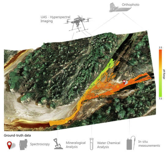
UAS-Based Hyperspectral Environmental Monitoring of Acid Mine Drainage Affected Waters
Abstract
1. Introduction
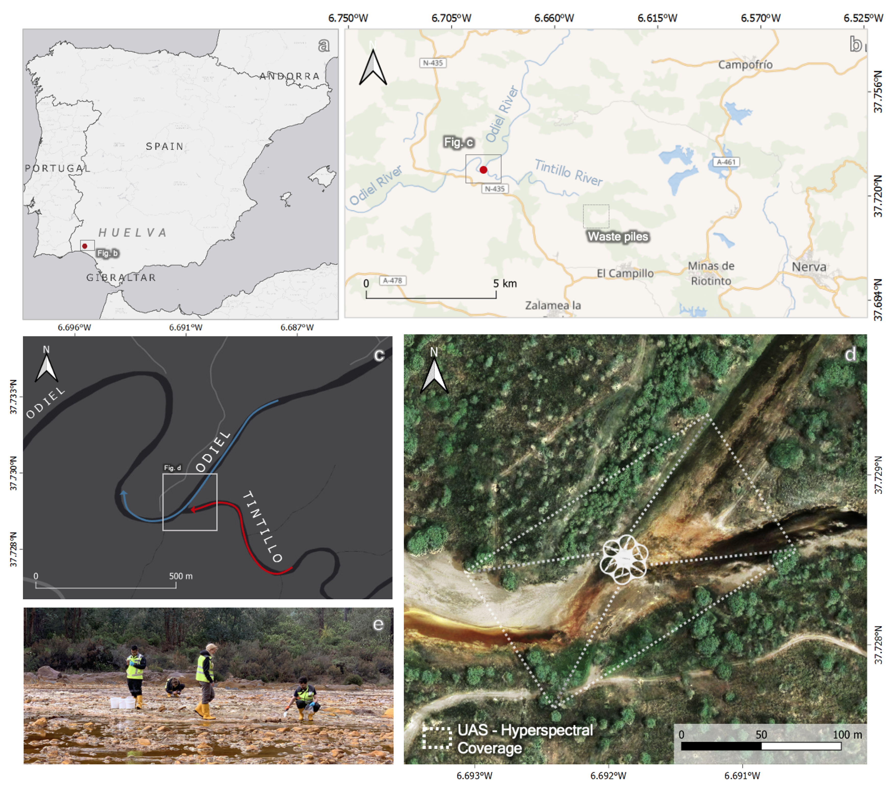
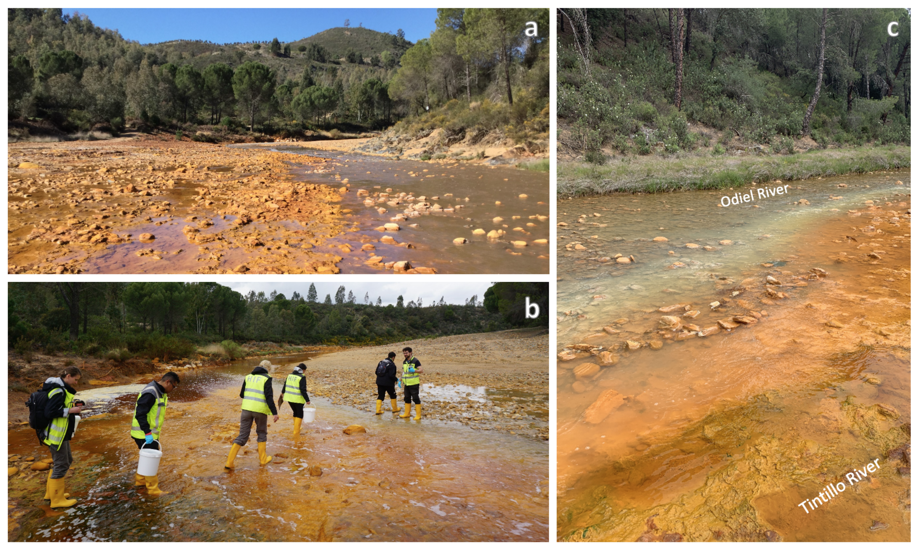
1.1. Test Site
1.2. Geological Framework
1.3. Hydrology and Climatology
2. Data Acquisition
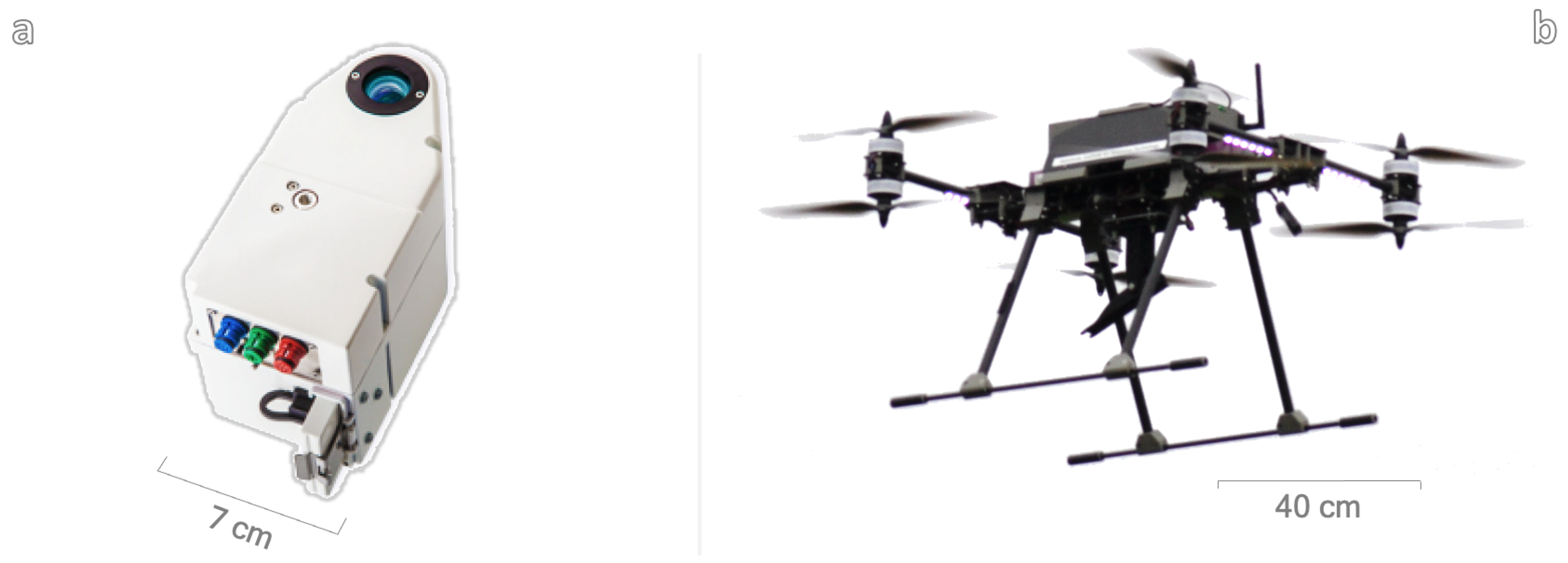
2.1. UAS-Borne Hyperspectral Data
2.1.1. Flight Set-Up
2.1.2. Pre-Processing
2.2. Ground-Truth Data
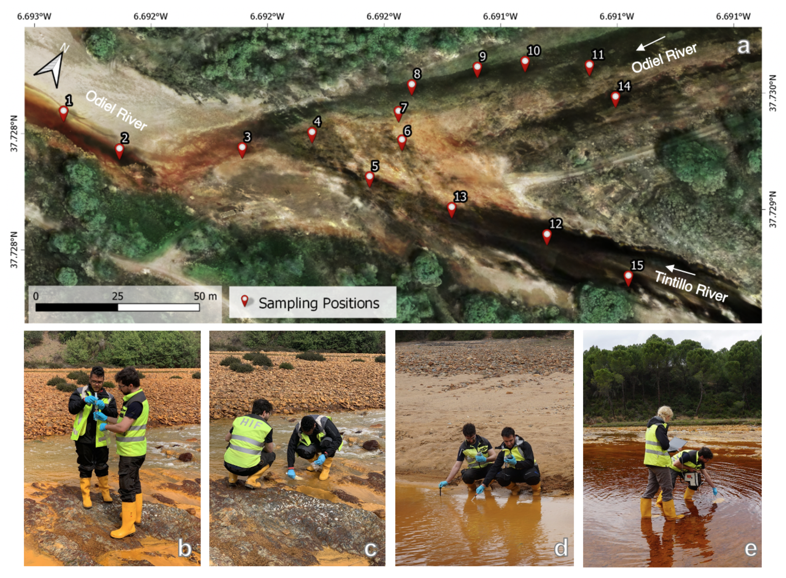
2.2.1. Field Measurements and Sampling
2.2.2. Analytical Techniques
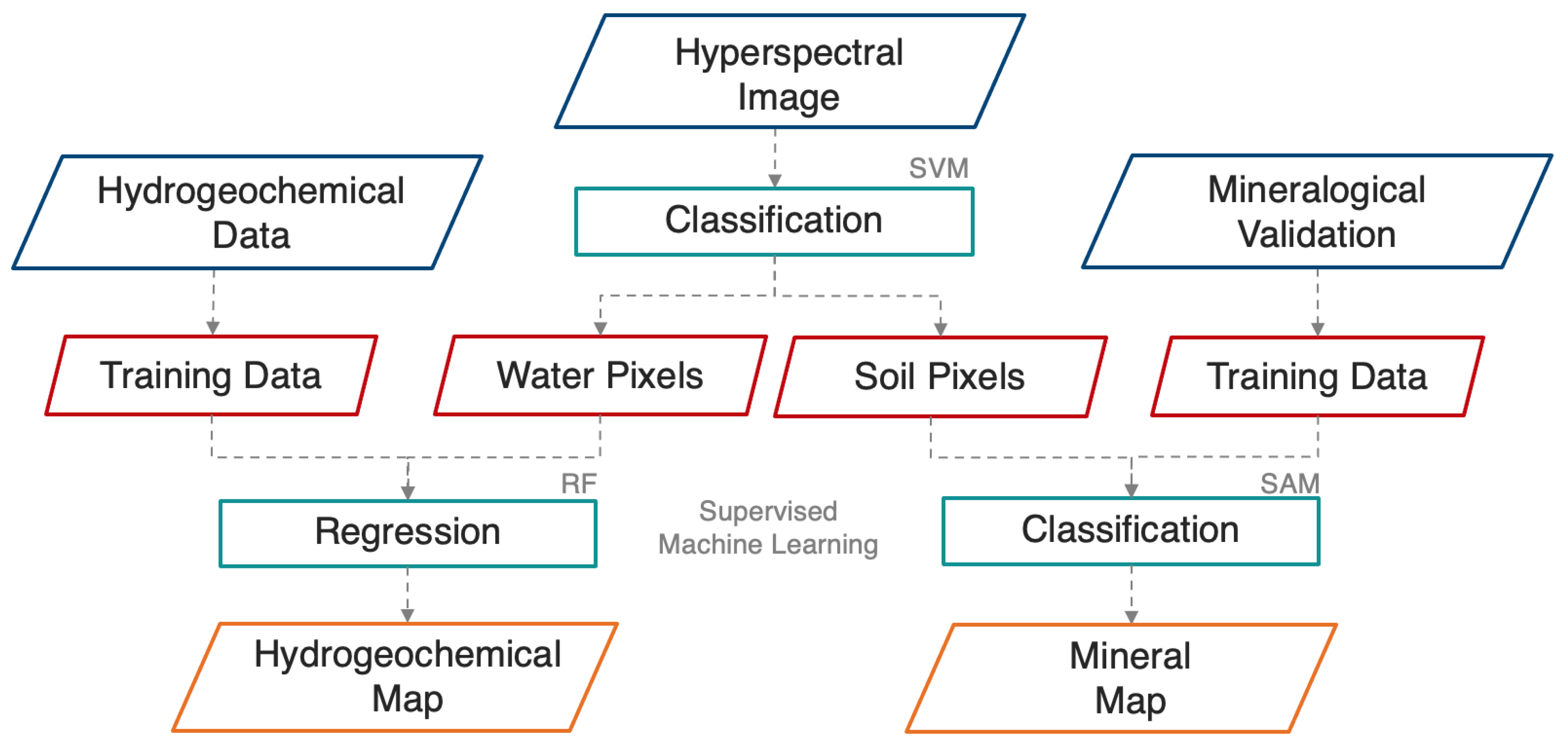
3. Methodological Framework
3.1. Surface Classification
3.1.1. Training Data
3.1.2. Support Vector Machine (SVM)
3.2. Hydrogeochemical Maps
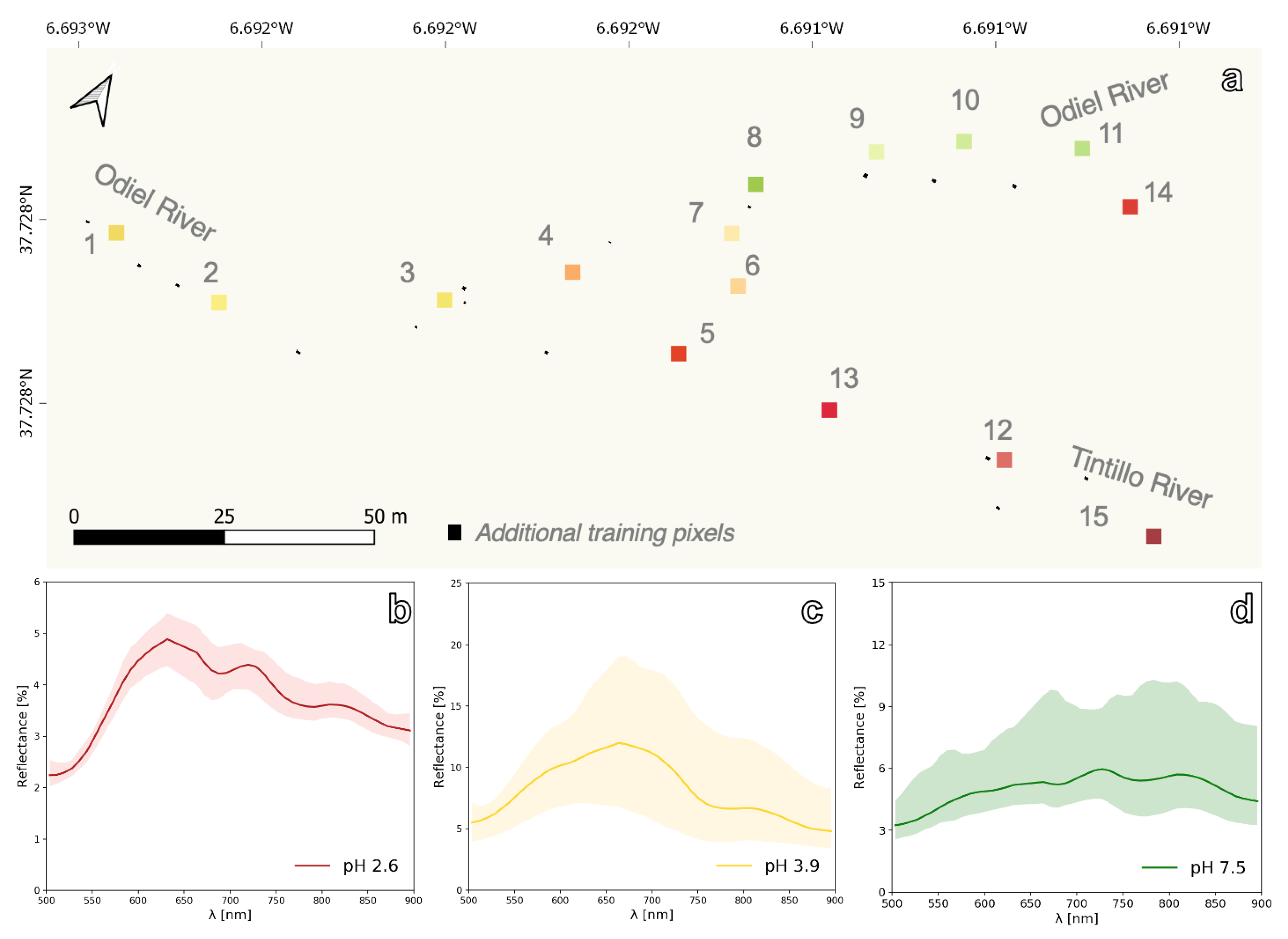
3.2.1. Training Data
3.2.2. Random Forest (RF)
3.3. Mineral Maps
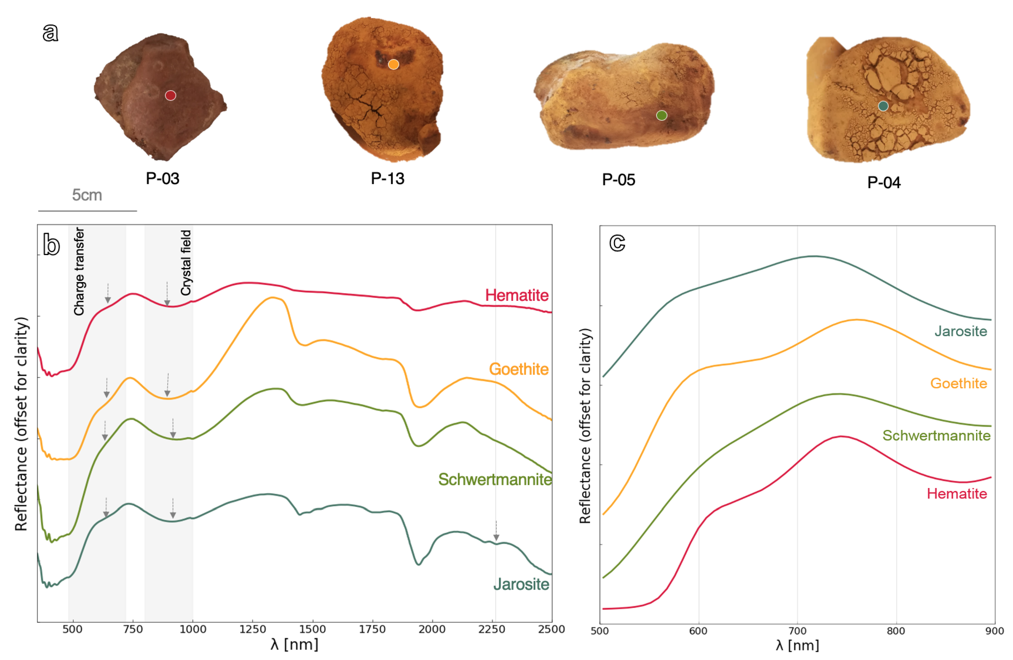
3.3.1. Endmember Spectral Library
3.3.2. Spectral Angle Mapper (SAM)
4. Results
4.1. Hydrogeochemical Maps
4.2. Mineral Maps
5. Discussion
5.1. Results Assessment
5.2. Relevance
5.3. Innovation
5.4. Outlook
6. Conclusions
Author Contributions
Funding
Institutional Review Board Statement
Informed Consent Statement
Data Availability Statement
Acknowledgments
Conflicts of Interest
Appendix A
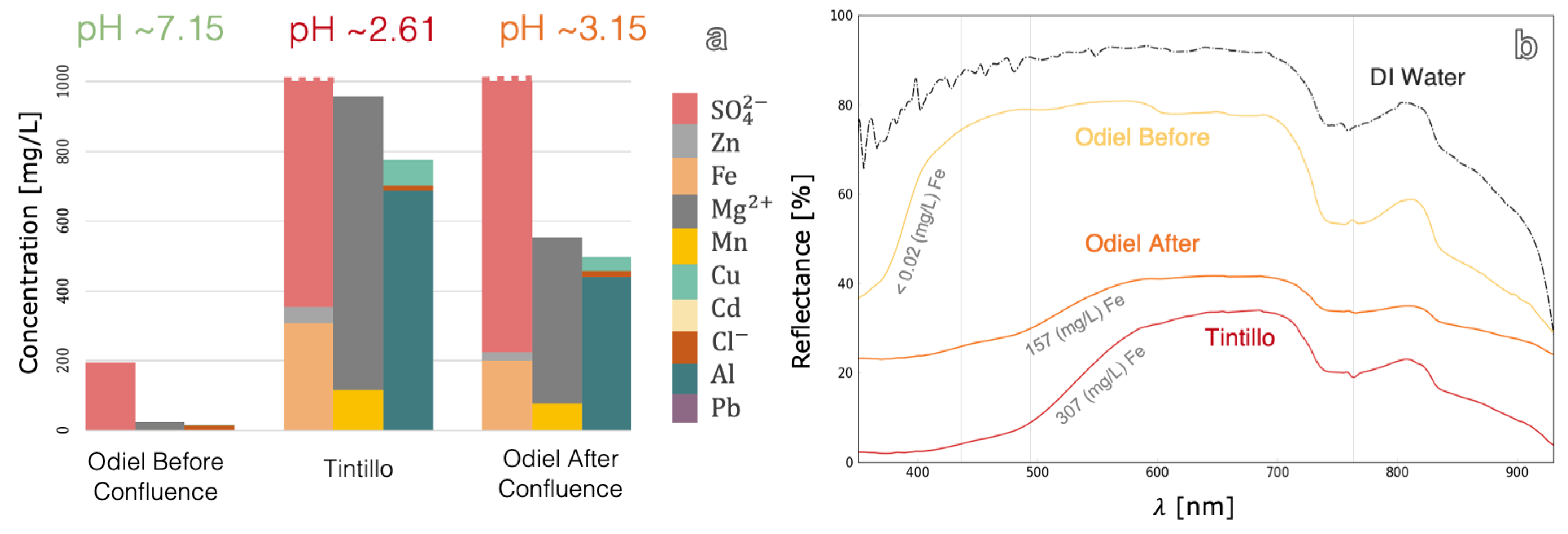
| River | ID | T (°C) | pH | Em (mV) | pe | EC ** (μS/cm) |
|---|---|---|---|---|---|---|
| Odiel Before Confluence | S11 | 19.4 | 6.88 | 239.4 | 7.62 | 409 |
| S8 | 19.6 | 4.73 | 394.2 | 10.23 | 515 | |
| S9 | 19.5 | 4.52 | 369.3 | 9.81 | 645 | |
| S10 | 19.4 | 7.9 | 204.2 | 7.02 | 373 | |
| S14 * | 20 | 2.63 | 561.7 | 13.06 | 9390 | |
| Tintillo | S12 | 19 | 2.63 | 574.5 | 13.29 | 9420 |
| S13 | 19.6 | 2.6 | 574.2 | 13.28 | 9460 | |
| S15 | 19 | 2.64 | 575.3 | 13.30 | 9430 | |
| S6 | 19.5 | 2.6 | 573.8 | 13.27 | 9530 | |
| S5 | 19.3 | 2.58 | 574 | 13.28 | 9500 | |
| Odiel After Confluence | S2 | 20.2 | 3.88 | 520.6 | 12.36 | 1152 |
| S3 | 19.7 | 2.8 | 577 | 13.32 | 5780 | |
| S1 | 20 | 3.99 | 506 | 12.12 | 9070 | |
| S4 | 19.5 | 2.58 | 575 | 13.29 | 9460 | |
| S7 | 19.3 | 2.58 | 572.3 | 13.25 | 9440 |
| River | ID | Mg | Cl− | Zn | Al | Fe | SO42− |
|---|---|---|---|---|---|---|---|
| mg/L | |||||||
| Odiel Before Confluence | S11 | 16.4 | 12.4 | 0.47 | 0.07 | <0.02 | 120 |
| S8 | 28.6 | 12.7 | 2.53 | 3.14 | 0.14 | 230 | |
| S9 | 29.3 | 12.2 | 2.65 | 4.09 | 0.08 | 330 | |
| S10 | 17.9 | 12.1 | 0.63 | 0.03 | 0.02 | 90 | |
| S14 | 854 | 18.7 | 143 | 687 | 300.51 | 10,000 | |
| Tintillo | S12 | 843 | 17.7 | 142 | 680 | 306.78 | 11000 |
| S13 | 826 | 18.0 | 21.9 | 672 | 297.81 | 9000 | |
| S15 | 836 | 17.6 | 22.6 | 681 | 302.02 | 9400 | |
| S6 | 824 | 17.5 | 23.4 | 671 | 301.15 | 10,000 | |
| S5 | 884 | 17.9 | 21.4 | 729 | 325.99 | 9000 | |
| Odiel After Confluence | S2 | 57.4 | 13.3 | 24.6 | 332.0 | 157.60 | 4900 |
| S3 | 428 | 16.0 | 24.4 | 339 | 165.20 | 5100 | |
| S1 | 242 | 14.2 | 21.6 | 189 | 73.80 | 700 | |
| S4 | 831 | 18.3 | 23.6 | 674 | 303.39 | 9000 | |
| S7 | 828 | 21.3 | 24.1 | 668 | 305.46 | 10,000 | |
| ID | Cd | Cu | Mn | Co | Ni | Pb | |
| mg/L | |||||||
| Odiel Before Confluence | S11 | <0.03 | 0.04 | 0.50 | 0.05 | 0.02 | <0.05 |
| S8 | <0.03 | 1.04 | 2.30 | 0.05 | 0.04 | <0.05 | |
| S9 | <0.03 | 1.13 | 2.28 | 0.05 | 0.04 | <0.05 | |
| S10 | <0.03 | 0.06 | 0.54 | 0.05 | 0.02 | <0.05 | |
| S14 | 0.69 | 74.1 | 116 | 4.36 | 1.44 | <0.05 | |
| Tintillo | S12 | 0.69 | 73.1 | 115 | 4.29 | 1.43 | <0.05 |
| S13 | 0.66 | 73.5 | 113 | 4.48 | 1.33 | <0.05 | |
| S15 | 0.64 | 71.1 | 112 | 4.26 | 1.34 | <0.05 | |
| S6 | 0.67 | 72.1 | 113 | 4.25 | 1.39 | <0.05 | |
| S5 | 0.65 | 76.2 | 122 | 4.42 | 1.40 | <0.05 | |
| Odiel After Confluence | S2 | 0.04 | 3.67 | 67.6 | 0.16 | 0.10 | <0.05 |
| S3 | 0.38 | 32.2 | 55.6 | 1.94 | 0.73 | <0.05 | |
| S1 | 0.21 | 18.5 | 31.5 | 1.04 | 0.40 | <0.05 | |
| S4 | 0.66 | 70.8 | 114 | 4.26 | 1.33 | <0.05 | |
| S7 | 0.68 | 70.4 | 113 | 4.47 | 1.41 | <0.05 | |
References
- Lottermoser, B. Mine Wastes; Springer: Berlin/Heidelberg, Germany, 2010; Volume 44, p. 085201. [Google Scholar] [CrossRef]
- Ferrier, G. Application of imaging spectrometer data in identifying environmental pollution caused by mining at Rodaquilar, Spain. Remote Sens. Environ. 1999, 68, 125–137. [Google Scholar] [CrossRef]
- Kemper, T.; Sommer, S. Estimate of heavy metal contamination in soils after a mining accident using reflectance spectroscopy. Environ. Sci. Technol. 2002, 36, 2742–2747. [Google Scholar] [CrossRef]
- Swayze, G.A.; Smith, K.S.; Clark, R.N.; Sutley, S.J.; Pearson, R.M.; Vance, J.S.; Hageman, P.L.; Briggs, P.H.; Meier, A.L.; Singleton, M.J.; et al. Using imaging spectroscopy to map acidic mine waste. Environ. Sci. Technol. 2000, 34, 47–54. [Google Scholar] [CrossRef]
- Montero, I.C.; Brimhall, G.H.; Alpers, C.N.; Swayze, G.A. Characterization of waste rock associated with acid drainage at the Penn Mine, California, by ground-based visible to short-wave infrared reflectance spectroscopy assisted by digital mapping. Chem. Geol. 2005, 215, 453–472. [Google Scholar] [CrossRef]
- Sares, M.; Hauff, P.; Peters, D.; Coulter, D. Characterizing Sources of Acid Rock Drainage and Resulting Water Quality Impacts Using Hyperspectral Remote Sensing–Examples from the Upper Arkansas. In Proceedings of the Advanced Integration of Geospatial Technologies in Mining Reclamation, Atlanta, GA, USA, 7–9 December 2004. [Google Scholar]
- Richter, N.; Staenz, K.; Kaufmann, H. Spectral unmixing of airborne hyperspectral data for baseline mapping of mine tailings areas. Int. J. Remote Sens. 2008, 29, 3937–3956. [Google Scholar] [CrossRef]
- Choe, E.; van der Meer, F.; van Ruitenbeek, F.; van der Werff, H.; de Smeth, B.; Kim, K.W. Mapping of heavy metal pollution in stream sediments using combined geochemistry, field spectroscopy, and hyperspectral remote sensing: A case study of the Rodalquilar mining area, SE Spain. Remote Sens. Environ. 2008, 112, 3222–3233. [Google Scholar] [CrossRef]
- Shang, J.; Morris, B.; Howarth, P.; Lévesque, J.; Staenz, K.; Neville, B. Mapping mine tailing surface mineralogy using hyperspectral remote sensing. Can. J. Remote Sens. 2009, 35, S126–S141. [Google Scholar] [CrossRef]
- Davies, G.E.; Calvin, W.M. Mapping acidic mine waste with seasonal airborne hyperspectral imagery at varying spatial scales. Environ. Earth Sci. 2017, 76, 1–14. [Google Scholar] [CrossRef]
- Crowley, J.K.; Williams, D.E.; Hammarstrom, J.M.; Piatak, N.; Chou, I.M.; Mars, J.C. Spectral reflectance properties (0.4–2.5 μm) of secondary Fe-oxide, Fe-hydroxide, and Fe-sulphate-hydrate minerals associated with sulphide-bearing mine wastes. Geochem. Explor. Environ. Anal. 2003, 3, 219–228. [Google Scholar] [CrossRef]
- Davies, G.E.; Calvin, W.M. Quantifying Iron Concentration in Local and Synthetic Acid Mine Drainage: A New Technique Using Handheld Field Spectrometers. Mine Water Environ. 2016, 36, 299–309. [Google Scholar] [CrossRef]
- Booysen, R.; Gloaguen, R.; Lorenz, S.; Zimmermann, R.; Nex, P.A. Geological Remote Sensing. In Reference Module in Earth Systems and Environmental Sciences, 2nd ed.; Elsevier: Amsterdam, The Netherlands, 2020; Volume 64, pp. 267–274. [Google Scholar] [CrossRef]
- Jackisch, R.; Lorenz, S.; Zimmermann, R.; Möckel, R.; Gloaguen, R. Drone-borne hyperspectral monitoring of acid mine drainage: An example from the Sokolov lignite district. Remote Sens. 2018, 10, 385. [Google Scholar] [CrossRef]
- Soriano, C.; Casas, J. Variscan tectonics in the Iberian Pyrite Belt, South Portuguese Zone. Int. J. Earth Sci. 2002, 91, 882–896. [Google Scholar] [CrossRef]
- Abad de los Santos, M.; Olías Álvarez, M.; Carro, B.M. Geología de Huelva lugares de interés geológico; Universidad de Huelva: Huelva, Spain, 2009; pp. 68–69. [Google Scholar]
- Sánchez, J.; López, E.; Santofimia, E.; Aduvire, O.; Reyes, J.; Barettino, D. Acid mine drainage in the Iberian Pyrite Belt (Odiel river watershed, Huelva, SW Spain): Geochemistry, mineralogy and environmental implications. Appl. Geochem. 2005, 20, 1320–1356. [Google Scholar] [CrossRef]
- Olias Alvarez, M.; Donaire Romero, T.; Mayoral Alfaro, E.; Morales Gonzalez, J.; Alonso Chaves, F.; Ruiz de Almodobar, G. Geologia de Huelva, Lugares de Interes Geologico; Aldina (Universidad de Huelva): Huelva, Spain, 2008. [Google Scholar]
- Sarmiento, A.M.; Nieto, J.M.; Olías, M.; Cánovas, C.R. Hydrochemical characteristics and seasonal influence on the pollution by acid mine drainage in the Odiel river Basin (SW Spain). Appl. Geochem. 2009, 24, 697–714. [Google Scholar] [CrossRef]
- Davis, R.A.; Welty, A.T.; Borrego, J.; Morales, J.A.; Pendon, J.G.; Ryan, J.G. Rio Tinto estuary (Spain): 5000 Years of pollution. Environ. Geol. 2000, 39, 1107–1116. [Google Scholar] [CrossRef]
- Sánchez, J.; Lopez, E.; Santofimia, E.; Aduvire, O.; Reyes, A.; Martín, J. The Tintillo acidic river (Rio Tinto mines, Huelva, Spain): An example of extreme environmental impact of pyritic mine wastes on the environment or an exceptional site to study acid-sulphate mine drainage systems? Int. Conf. Min. Environ. Met. Energy Recovery 2006, 1, 278–287. [Google Scholar]
- Sánchez Espańa, J.; Pamo, E.L.; Pastor, E.S.; Andrés, J.R.; Rubí, J.A. The impact of acid mine drainage on the water quality of the Odiel river (Huelva, Spain): Evolution of precipitate mineralogy and aqueous geochemistry along the Concepción-Tintillo segment. Water Air Soil Pollut. 2006, 173, 121–149. [Google Scholar] [CrossRef]
- Riaza, A.; Buzzi, J.; García-Meléndez, E.; Carrère, V.; Sarmiento, A.; Müller, A. Monitoring acidic water in a polluted river with hyperspectral remote sensing (HyMap). Hydrol. Sci. J. 2015, 60, 1064–1077. [Google Scholar] [CrossRef]
- Senop Oy. VIS-VNIR Snapshot Hyperspectral Camera for UAVs; Technical Report; Senop Oy: Laukaa, Finland, 2020. [Google Scholar]
- Jakob, S.; Zimmermann, R.; Gloaguen, R. The Need for Accurate Geometric and Radiometric Corrections of Drone-Borne Hyperspectral Data for Mineral Exploration: MEPHySTo-A Toolbox for Pre-Processing Drone-Borne Hyperspectral Data. Remote Sens. 2017, 9, 88. [Google Scholar] [CrossRef]
- Karpouzli, E.; Malthus, T. The empirical line method for the atmospheric correction of IKONOS imagery. Int. J. Remote Sens. 2003, 24, 1143–1150. [Google Scholar] [CrossRef]
- Savitzky, A.; Golay, M.J. Smoothing and Differentiation of Data by Simplified Least Squares Procedures. Anal. Chem. 1964, 36, 1627–1639. [Google Scholar] [CrossRef]
- Nordstrom, D.K. Thermochemical redox equilibria of ZoBells solution. Geochim. Cosmochim. 1977, 41, 1835–1841. [Google Scholar] [CrossRef]
- Baird, R.; Eaton, A.; Rice, E. Standard Methods for the Examination of Water and Wastewater; American Public Health Association: Washington, DC, USA, 2017. [Google Scholar]
- Hach. DR3900 Laboratory Spectrophotometer for Water Analysis User Manual; Technical Report; Hach: Loveland, CO, USA, 2013. [Google Scholar]
- Agilent Technologies. Microwave Plasma Atomic Emission Spectroscopy (MP-AES) Application eHandbook; Technical Report; Agilent Technologies: Santa Clara, CA, USA, 2016. [Google Scholar]
- Gates-Rector, S.; Blanton, T. The Powder Diffraction File: A quality materials characterization database. Powder Diffr. 2019, 34, 352–360. [Google Scholar] [CrossRef]
- Doebelin, N.; Kleeberg, R. Profex: A graphical user interface for the Rietveld refinement program BGMN. J. Appl. Crystallogr. 2015, 48, 1573–1580. [Google Scholar] [CrossRef] [PubMed]
- Rasti, B.; Ulfarsson, M.O.; Sveinsson, J.R. Hyperspectral Feature Extraction Using Total Variation Component Analysis. IEEE Trans. Geosci. Remote Sens. 2016, 54, 6976–6985. [Google Scholar] [CrossRef]
- Ghamisi, P.; Plaza, J.; Chen, Y.; Li, J.; Plaza, A.J. Advanced Spectral Classifiers for Hyperspectral Images: A review. IEEE Geosci. Remote Sens. Mag. 2017, 5, 8–32. [Google Scholar] [CrossRef]
- Vapnik, V.N. An overview of statistical learning theory. IEEE Trans. Neural Netw. 1999, 10, 988–999. [Google Scholar] [CrossRef] [PubMed]
- Cortes, C.; Vapnik, V.N. Support-Vector Networks. Mach. Learn. 1995, 20, 273–297. [Google Scholar] [CrossRef]
- Waske, B.; Benediktsson, J.A.; Arnason, K.; Sveinsson, J.R. Mapping of hyperspectral AVIRIS data using machine-learning algorithms. Can. J. Remote Sens. 2009, 35, S106–S116. [Google Scholar] [CrossRef]
- Chang, C.C.; Lin, C.J. LIBSVM: A Library for support vector machines. ACM Trans. Intell. Syst. Technol. 2011, 2, 2–5. [Google Scholar] [CrossRef]
- Safavian, S.; Landgrebe, D. A survey of decision tree classifier methodology. IEEE Trans. Syst. Man Cybern. 1991, 21, 660–674. [Google Scholar] [CrossRef]
- Breiman, L. Random Forest. Mach. Learn. 2001, 45, 5–32. [Google Scholar] [CrossRef]
- Rodriguez-Galiano, V.; Sanchez-Castillo, M.; Chica-Olmo, M.; Chica-Rivas, M. Machine learning predictive models for mineral prospectivity: An evaluation of neural networks, random forest, regression trees and support vector machines. Ore Geol. Rev. 2015, 71, 804–818. [Google Scholar] [CrossRef]
- Kokaly, R.; Clark, R.; Swayze, G.; Livo, K.; Hoefen, T.; Pearson, N.; Wise, R.; Benzel, W.; Lowers, H.; Driscoll, R.; et al. USGS Digital Spectral Library: Version 7; Technical Report; USGS: Reston, VA, USA, 2007. [CrossRef]
- Leybourne, M.I.; Pontual, S.; Peter, J.M. Integrating Hyperspectral Mineralogy, Mineral Chemistry, Geochemistry and Geological Data at Different Scales in Iron Ore Mineral Exploration. Proc. Iron Ore Conf. 2008, 3, 1–10. [Google Scholar]
- Hunt, G.R. Spectral Signatures of Particulate Minerals in the Visible and Near Infrared. Geophysics 1977, 42, 501–513. [Google Scholar] [CrossRef]
- Kruse, F.A.; Lefkoff, A.B.; Dietz, J.B. Expert system-based mineral mapping in northern death valley, California/Nevada, using the Airborne Visible/Infrared Imaging Spectrometer (AVIRIS). Remote Sens. Environ. 1993, 44, 309–336. [Google Scholar] [CrossRef]
- Buzzi, J.; Riaza, A.; García-Meléndez, E.; Carrère, V.; Holzwarth, S. Monitoring of River Contamination Derived From Acid Mine Drainage Using Airborne Imaging Spectroscopy (HyMap Data, South-West Spain). River Res. Appl. 2016, 32, 125–136. [Google Scholar] [CrossRef][Green Version]
- Dozier, J.; Painter, T.H. Multispectral and Hyperspectral Remote Sensing of Alpine Snow Properties. Annu. Rev. Earth Planet. Sci. 2004, 32, 465–494. [Google Scholar] [CrossRef]
- Green, R.O.; Painter, T.H.; Roberts, D.A.; Dozier, J. Measuring the expressed abundance of the three phases of water with an imaging spectrometer over melting snow. Water Resour. Res. 2006, 42. [Google Scholar] [CrossRef]
- SenseFly. 3 Reasons to Choose the eBee Plus; Technical Report; SenseFly: Cheseaux, Switzerland, 2017. [Google Scholar]
- Parrot Group. Parrot Sequoia Technical Specifications; Technical Report; Parrot Group: Paris, France, 2016. [Google Scholar]

| Parameter | Value |
|---|---|
| Image Resolution | 1010 × 648 Pixel |
| Spectral Bands | 50 |
| Field of View (FOV) | 36.5 |
| Focal length | ∼9 mm |
| Spectral resolution | ∼10 nm, FWHM |
| Spectral sampling | ∼8 nm |
| Weight | 720 g |
| Parameter | Value |
|---|---|
| Flight altitude (above take-off) | 50 m |
| Ground resolution | 3.25 cm/px |
| Number of Flights | 2 |
| Flight duration (total) | 12 min |
| Number of scenes | 140 |
| Area covered | 14,000 m2 |
| Variables | Internal Validation R2 | External Validation R2 |
|---|---|---|
| pH | 0.99 | 0.73 |
| Redox | 0.99 | 0.82 |
| SO42− | 0.99 | 0.61 |
| Al | 0.99 | 0.68 |
| Fe | 0.99 | 0.66 |
Publisher’s Note: MDPI stays neutral with regard to jurisdictional claims in published maps and institutional affiliations. |
© 2021 by the authors. Licensee MDPI, Basel, Switzerland. This article is an open access article distributed under the terms and conditions of the Creative Commons Attribution (CC BY) license (http://creativecommons.org/licenses/by/4.0/).
Share and Cite
Flores, H.; Lorenz, S.; Jackisch, R.; Tusa, L.; Contreras, I.C.; Zimmermann, R.; Gloaguen, R. UAS-Based Hyperspectral Environmental Monitoring of Acid Mine Drainage Affected Waters. Minerals 2021, 11, 182. https://doi.org/10.3390/min11020182
Flores H, Lorenz S, Jackisch R, Tusa L, Contreras IC, Zimmermann R, Gloaguen R. UAS-Based Hyperspectral Environmental Monitoring of Acid Mine Drainage Affected Waters. Minerals. 2021; 11(2):182. https://doi.org/10.3390/min11020182
Chicago/Turabian StyleFlores, Hernan, Sandra Lorenz, Robert Jackisch, Laura Tusa, I. Cecilia Contreras, Robert Zimmermann, and Richard Gloaguen. 2021. "UAS-Based Hyperspectral Environmental Monitoring of Acid Mine Drainage Affected Waters" Minerals 11, no. 2: 182. https://doi.org/10.3390/min11020182
APA StyleFlores, H., Lorenz, S., Jackisch, R., Tusa, L., Contreras, I. C., Zimmermann, R., & Gloaguen, R. (2021). UAS-Based Hyperspectral Environmental Monitoring of Acid Mine Drainage Affected Waters. Minerals, 11(2), 182. https://doi.org/10.3390/min11020182


