Evaluation of the Completeness of Spatial Data Infrastructure in the Context of Cadastral Data Sharing


Abstract
1. Introduction
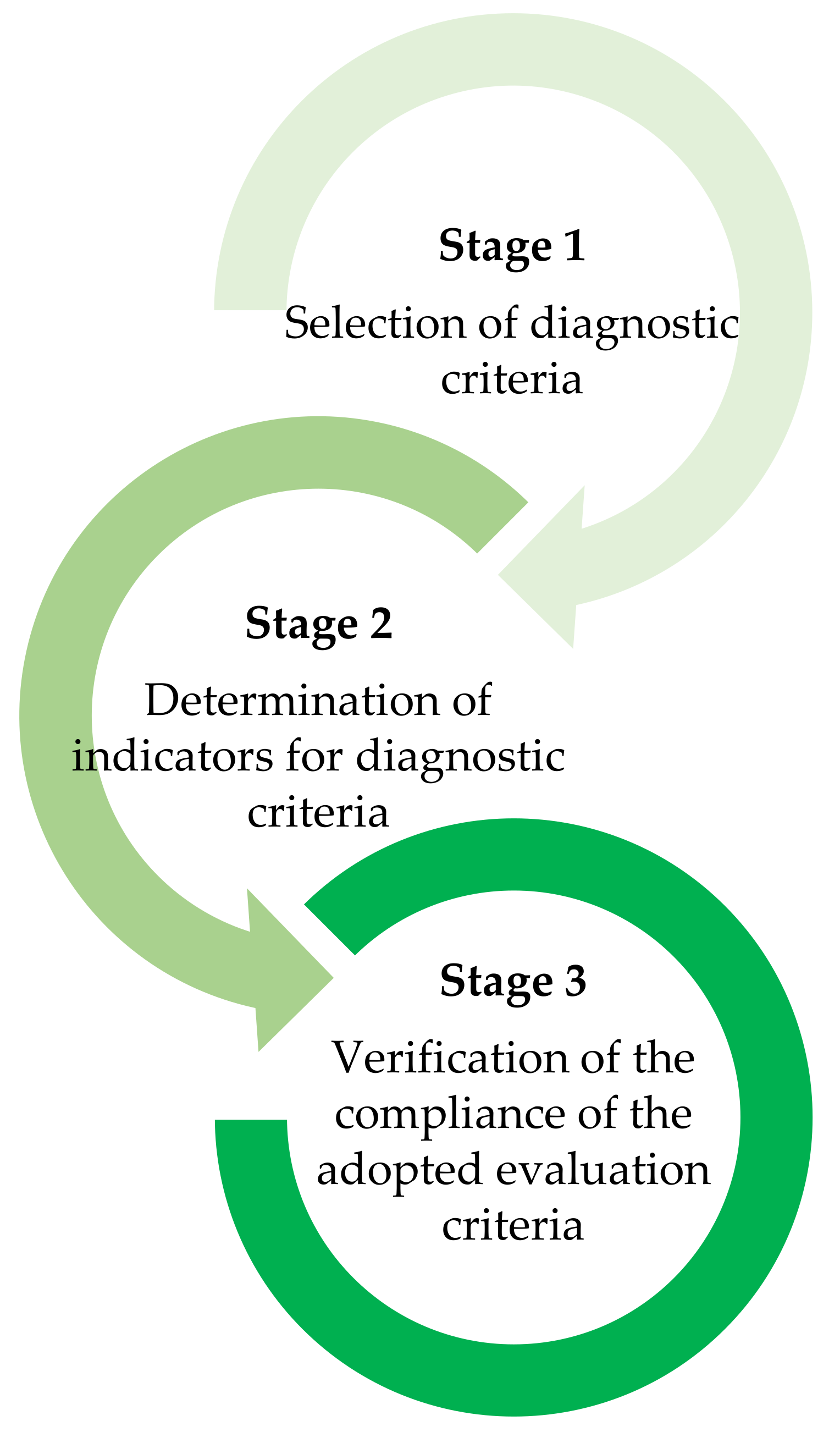
- The determination of the main objective of service evaluation.
- The description of the criteria for diagnosing the functionality of websites publishing cadastral data and access to cadastral data (legal, organizational, and technical aspects).
- The development of indicators for evaluating selected diagnostic criteria.
- The interpretation of the results of cadastral service evaluation.
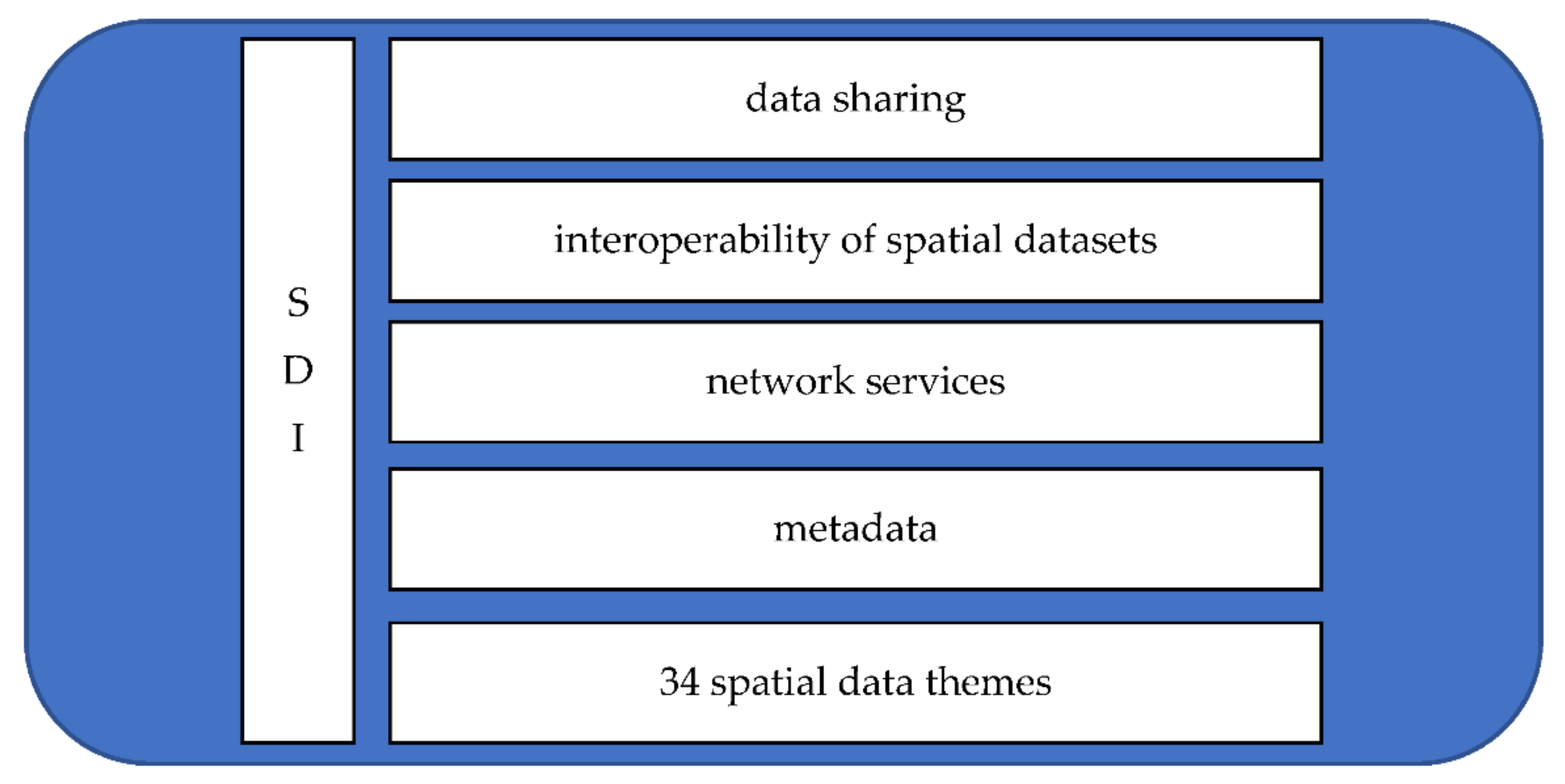
2. Background
- Discovery services that support the search for spatial datasets and services based on the content of the corresponding metadata, as well as enabling users to display metadata content.
- View services that, as a minimum, enable users to display, navigate, zoom in/out, pan, or overlay viewable spatial datasets, as well as to display legend information and any relevant metadata content.
- Download services that enable users to copy, download, and, where practicable, directly access spatial datasets or parts of such sets.
- Transformation services that enable users to transform spatial datasets with a view to achieving interoperability.
- Services that enable users to invoke spatial data services.
- GetMap—for viewing cadastral maps in the PNG format.
- GetFeatureInfo—for accessing information such as cadastral parcel ID, parcel number, the territorial unit for which the cadastral database is kept, the number of the land and mortgage register, and the date on which cadastral data were last updated.
- GetCapabilities for accessing data layers via the WMS and basic layer parameters such as coordinate systems, graphic formats, and accessible data themes.
- GetCapabilities, which returns metadata.
- DescribeFeatureType, which returns a description of feature types from the cadastral parcel layer.
- GetFeature, which returns the cadastral parcel, its geometry and features based on the legal definition, parcel identification data, or coordinates.
3. Materials and Methods
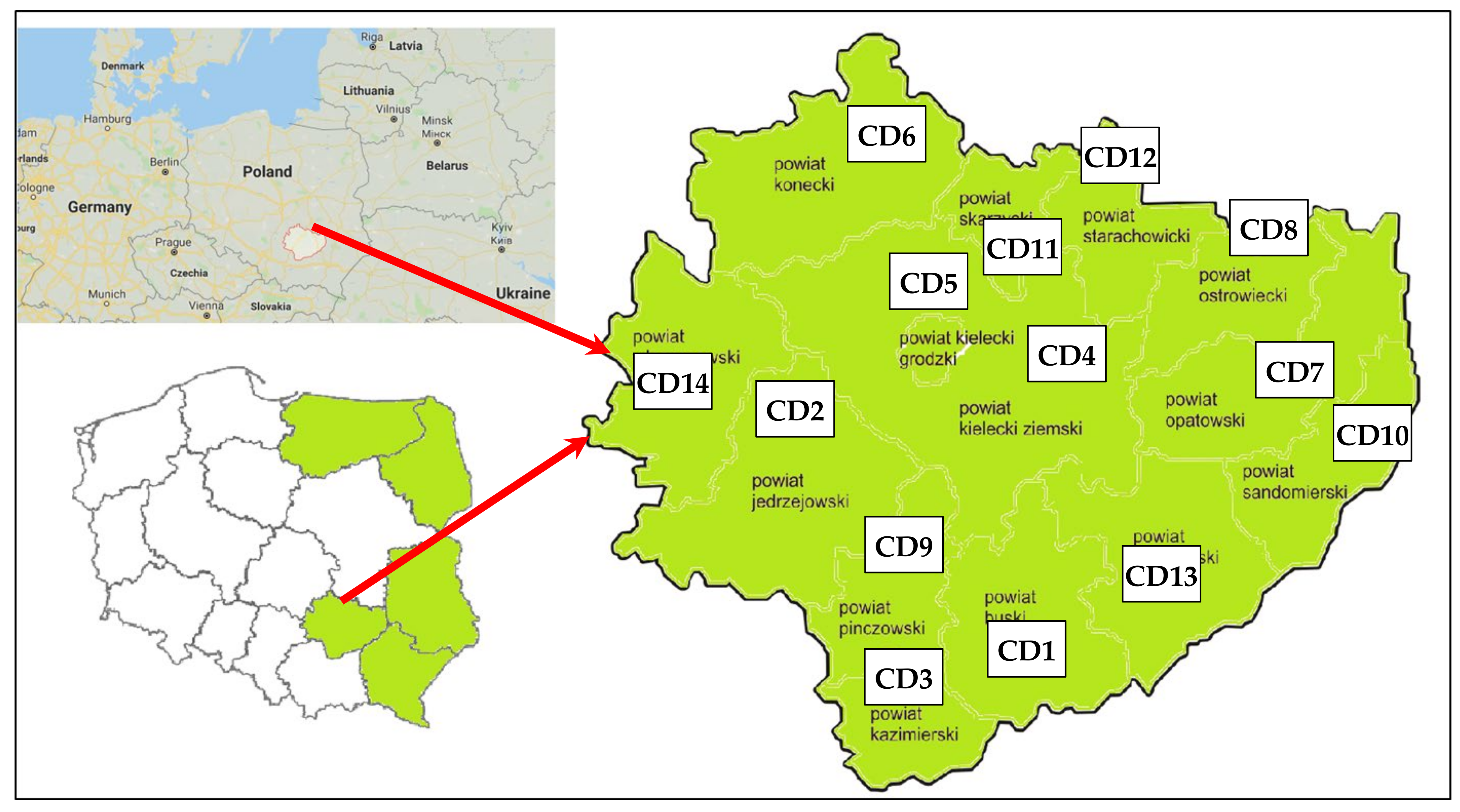
3.1. Study Area
3.2. Methodology
- A review of the literature addressing the problem, with the main focus on selected legal, organizational, and technical aspects related to the publication of cadastral data using network services such as the WMS and the WFS.
- Research into the usability of websites publishing cadastral data combined with an expert interview.
- An analysis of the register of spatial datasets and services with the aim of exploring its structure and operating principles.
- Evaluations involving the identification of success or failure criteria for the online publication of cadastral data.
- Inference aiming to formulate, in a clear and unambiguous manner, the crucial results of the evaluation of selected websites that publish cadastral data.
- Directive 2007/2/EC of the European Parliament and of the Council of 14 March 2007 Establishing an Infrastructure for Spatial Information in the European Community [2].
- Act on Spatial Data Infrastructure of 4 March 2010 [28].
- Geodetic and Cartographic Law of 17 May 1989 [37].
- Regulation of the Minister of Regional Development and Construction of 29 March 2001 on land and building registers [38].
- ISO 19128 [4].
- ISO 19142 [5].
- Technical specifications for county-level WMSs relating to land and building registers.
- Interviews with the experts employed by the County Centre for Geodetic and Cadastral Documentation in Świętokrzyskie Voivodeship.
- Analysis of the structure and operating principles of the register of spatial datasets and spatial data services kept by the Head Office of Geodesy and Cartography (HOGC).
- Excellent (EXC)—100% of possible points for every adopted criterion; the evaluated SDI is fully complete.
- Above Average (AAVG)—More than 60% of possible points for every adopted criterion; the evaluated SDI is characterized by above-average completeness.
- Average (AVG)—More than 40% of possible points for every adopted criterion; the evaluated SDI is characterized by average completeness.
- Below Average (BAVG)—More than 20% of possible points for every adopted criterion; the evaluated SDI is characterized by below-average completeness.
- Negative (NEG)—0–20% of possible points for every adopted criterion; the evaluated SDI is characterized by critical-level completeness.
4. Discussion
5. Conclusions
Author Contributions
Funding
Conflicts of Interest
References
- Izdebski, W. Analysis of the cadastral data published in the Polish Spatial Data Infrastructure. Geod. Cartogr. 2017, 66, 227–240. [Google Scholar] [CrossRef][Green Version]
- Directive 2007/2/EC of the European Parliament and of the Council of 14 March 2007 Establishing an Infrastructure for Spatial Information in the European Community. Available online: http://data.europa.eu/eli/dir/2007/2/oj (accessed on 12 January 2020).
- Open GIS Consortium Inc. OpenGIS Web Map Server Implementation Specification. 2006. Available online: https://www.ogc.org/standards/wms (accessed on 13 January 2020).
- ISO 19128: 2005. Geographic Information—Web Map Server Interface. Available online: https://www.iso.org/standard/32546.html (accessed on 15 January 2020).
- ISO 19142: 2011. Geographic Information—Web Feature Service. Available online: https://www.iso.org/standard/42136.html (accessed on 16 January 2020).
- INSPIRE Network Services. Available online: https://inspire.ec.europa.eu/network-services/41 (accessed on 17 June 2020).
- About INSPIRE. Available online: https://inspire.ec.europa.eu/about-inspire/563 (accessed on 18 June 2020).
- Pashova, L.; Bandrova, T. A brief overview of current status of European spatial data infrastructures—Relevant developments and perspectives for Bulgaria. Geo. Spat. Inf. Sci. 2017, 20, 97–108. [Google Scholar] [CrossRef]
- Kaufmann, J.; Steudler, D. Cadastre 2014 a Vision for a Future Cadastral System; International Federation of Surveyors (FIG): Copenhagen, Denmark, 1998. [Google Scholar]
- Pržulj, D.; Radaković, N.; Sladić, D.; Radulović, A.; Govedarica, M. Domain model for cadastral systems with land use component. Surv. Rev. 2019, 51, 135–146. [Google Scholar] [CrossRef]
- Dawidowicz, A.; Źróbek, R. A methodological evaluation of the Polish cadastral system based on the global cadastral model. Land Use Policy 2018, 73, 59–72. [Google Scholar] [CrossRef]
- Mika, M. An analysis of possibilities for the establishment of a multipurpose and multidimensional cadaster in Poland. Land Use Policy 2018, 77, 446–453. [Google Scholar] [CrossRef]
- Hull, S.; Whittal, J. Human rights in tension: Guiding cadastral systems development in customary land rights contexts. Surv. Rev. 2019, 51, 97–113. [Google Scholar] [CrossRef]
- Izdebski, W. Good practices of participation of communes and districts in creating spatial data infrastructure in Poland. Available online: http://www.izdebski.edu.pl/index.php?akcja=publikacje&kat=23 (accessed on 27 July 2019).
- Krigsholm, P.; Zavialova, S.; Riekkinen, K.; Ståhle, K.; Viitanen, K. Understanding the future of the Finnish cadastral system—A Delphi study. Land Use Policy 2017, 68, 133–140. [Google Scholar] [CrossRef]
- Thompson, R.J. A model for the creation and progressive improvement of a digital cadastral data base. Land Use Policy 2015, 49, 565–576. [Google Scholar] [CrossRef]
- Otwarte Dane. Ewidencja gruntów i budynków. Available online: https://dane.gov.pl/dataset/925,dziaki-katastralne-inspire-cp (accessed on 17 June 2020).
- Craglia, M. INSPIRE: Towards a Participatory Digital Earth. Geospatial World. 2014. Available online: https://www.geospatialworld.net/article/inspire-towards-a-participatory-digital-earth/ (accessed on 12 August 2019).
- Kotsev, A.; Peeters, O.; Smits, P.; Grothe, M. Building bridges: Experiences and lessons learned from the implementation of INSPIRE and e-reporting of air quality data in Europe. Earth Sci. Inform. 2014, 8, 353–365. [Google Scholar] [CrossRef]
- Bydłosz, J. The application of the Land Administration Domain Model in building a country profile for the Polish cadaster. Land Use Policy 2015, 49, 598–605. [Google Scholar] [CrossRef]
- Cagdas, A.C.; Bovkir, R. Generic land registry and cadaster data model supporting interoperability based on international standards for Turkey. Land Use Policy 2017, 68, 59–71. [Google Scholar] [CrossRef]
- Williamson, I.P.; Rajabifard, A.; Feeney, M.E.F. Developing Spatial Data Infrastructures, from Concept to Reality; Taylor and Francis Group: London, UK; New York, NY, USA, 2003; pp. 3–16. [Google Scholar]
- Kliment, T.; Granell, C.; Cetl, V.; Kliment, M. Publishing OGC resources discovered on the mainstream web in an SDI catalogue. In Proceedings of the 16th AGILE International Conference on Geographic Information Science, Leuven, Belgium, 14–17 May 2013; pp. 1–6. Available online: https://agile-online.org/conference_paper/cds/agile_2013/short_papers/sp_s5.3_kliment.pdf (accessed on 10 August 2019).
- Stella, G.; Coli, R.; Maurizi, A.; Famiani, F.; Castellini, C.; Pauselli, M.; Tosti, G.; Menconi, M.E. Towards a National Food Sovereignty Plan: Application of a new Decision Support System for food planning and governance. Land Use Policy 2019, 89, 104216. [Google Scholar] [CrossRef]
- European Commission Joint Research Centre. D2.8.I.6 Data Specification on Cadastral Parcels—Technical Guidelines. 2014. Available online: https://inspire.ec.europa.eu/documents/Data_Specifications/INSPIRE_DataSpecification_CP_v3.1.pdf (accessed on 15 August 2019).
- European Commission Joint Research Centre. D2.8.III.2 Data Specification on Buildings—Draft Technical Guidelines. 2013. Available online: https://inspire.ec.europa.eu/documents/Data_Specifications/INSPIRE_DataSpecification_BU_v3.0rc3.pdf (accessed on 15 August 2019).
- Head Office of Geodesy and Cartography. Available online: http://www.gugik.gov.pl/bip/inspire (accessed on 2 August 2019).
- Law on Spatial Data Infrastructure. 2010. Available online: http://isap.sejm.gov.pl/isap.nsf/download.xsp/WDU20100760489/O/D20100489.pdf (accessed on 11 September 2019).
- Gaździcki, J. Geospatial information in Poland: Development and new challenges. Polish Association for Spatial Information. Ann. Geomat. 2017, 2, 139–145. Available online: http://rg.ptip.org.pl/index.php/rg/article/view/RG2017-2_Gazdzicki/1712 (accessed on 23 February 2020).
- Eurostat Regional Yearbook 2018 Edition. Available online: https://ec.europa.eu/eurostat/web/products-statistical-books/-/KS-HA-18-001 (accessed on 4 September 2019).
- Kocur-Bera, K. Data compatibility between the Land and Building Cadaster (LBC) and the Land Parcel Identification System (LPIS) in the context of area-based payments: A case study in the Polish Region of Warmia and Mazury. Land Use Policy 2019, 80, 370–379. [Google Scholar] [CrossRef]
- Berriet-Solliec, M.; Labarthe, P.; Laurent, C. Goals of evaluation and types of evidence. Evaluation 2014, 20, 195–213. [Google Scholar] [CrossRef]
- Johnson, R.B.; Onwuegbuzie, A.J. Mixed methods research: A research paradigm whose time has come. Educat. Res. 2004, 33, 14–26. [Google Scholar] [CrossRef]
- Kaufmann, J.; Kaul, C. Assessment of the core cadastral domain model from a cadaster point of view. In FIG 2004: Standardization in the Cadastral Domain: Proceedings of the Workshop Standardization in the Cadastral Domain, Bamberg, Germany, 9–10 December 2004; FIG: Copenhagen, Denmark, 2004. [Google Scholar]
- Rajabifard, A.; Williamson, I.; Steudler, D.; Binns, A.; King, M. Assessing the worldwide comparison of cadastral systems. Land Use Policy 2007, 24, 275–288. [Google Scholar] [CrossRef]
- Bennett, R.M.; Pickering, M.; Sargent, J. Transformations, transitions, or tall tales? A global review of the uptake and impact of NoSQL, blockchain, and big data analytics on the land administration sector. Land Use Policy 2019, 83, 435–448. [Google Scholar] [CrossRef]
- Geodetic and Cartographic Law of 17 May 1989. Available online: http://isap.sejm.gov.pl/isap.nsf/download.xsp/WDU20190000725/U/D20190725Lj.pdf (accessed on 24 September 2019).
- Regulation of the Minister of Regional Development and Construction of 29 March 2001 on Land and Building Registers. Available online: http://isap.sejm.gov.pl/isap.nsf/download.xsp/WDU20160001034/O/D20161034.pdf (accessed on 24 September 2019).
- Register of Spatial Datasets and Services. Available online: https://www.geoportal.gov.pl/ewidencja-zbiorow-i-uslug (accessed on 12 December 2019).
- Thellufsen, C.; Rajabifard, A.; Enemark, S.; Williamson, I. Awareness as a foundation for developing effective spatial data infrastructures. Land Use Policy 2009, 26, 254–261. [Google Scholar] [CrossRef]
- Trystuła, A. Cadastral databases in web map service supporting rural development policies. Infrastruct. Ecol. Rural Areas 2014, 319–331. Available online: http://www.infraeco.pl/pl/art/a_17317.html (accessed on 11 August 2020).
- Masser, I.; Crompvoets, J. Building European Spatial Data Infrastructures; Esri Press: Relands, CA, USA, 2015. [Google Scholar]
- Nushi, B.; van Loenen, B.; Crompvoets, J. The STIG—A new SDI assessment method. Int. J. Spat. Data Infrastruct. Res. 2015, 10, 55–83. [Google Scholar]
- Mijić, N.; Bartha, G. Infrastructure for Spatial Information in European Community (INSPIRE) through the Time from 2007 until 2017. In Advanced Technologies, Systems, and Applications III; Lecture Notes in Networks and Systems; Avdaković, S., Ed.; Springer: Cham, Switzerland, 2019; Volume 60. [Google Scholar]
- Jarząbek, J.; Surma, E. The Draft Project Concerning Development of the Spatial Information Infrastructure in the Period 2016–2017. Available online: http://www.radaiip.gov.pl/__data/assets/pdf_file/0016/34342/Projekt-programu-budowy-IIP-w-latach-2016-2017.pdf (accessed on 15 May 2019).
- van Oosterom, P.; Groothedde, A.; Lemmen, C.; van der Molen, P.; Uitermark, H. Land administration as a cornerstone in the global spatial information infrastructure. Int. J. Spat. Data Infrastruct. Res. 2009, 4, 298–331. [Google Scholar]
- Enemark, S. From Cadastre to Land Governance: A Cadastre 2014 Outlook. In Proceedings of the 15th FIG International Congress, Kuala Lumpur, Malaysia, 16–21 June 2014. [Google Scholar]


| Symbol | Diagnostic Criteria |
|---|---|
| A | Technical and legal identifiers |
| B | Cadastral data profile |
| C | WMS network service |
| D | WFS network service |
| E | Sources of data for databases of cadastral parcels (Annex I, theme 1.6) and buildings (Annex III, theme 3.2) |
| F | Standardization of WMS and WFS |
| G | Data validity |
| Diagnostic Criterion | Indicator | Symbol | Validity (0–1) |
|---|---|---|---|
| A | Ordinal number of cadastral dataset | A1 | 0–1 |
| Publication date of cadastral dataset | A2 | ||
| Notification date of cadastral dataset | A3 | ||
| Notifying entity | A4 | ||
| Identifier of cadastral dataset | A5 | ||
| Name of cadastral dataset | A6 | ||
| Code of cadastral dataset | A7 | ||
| Legal regulations | A8 |
| Diagnostic Criterion | Indicator | Symbol | Validity (0–1) |
|---|---|---|---|
| B | Annex I, theme1.6 *
| B1 | 0–1 |
Annex III, theme 3.2 *
| B2 |
| Diagnostic Criterion | Indicator | Symbol | Validity (0–1) |
|---|---|---|---|
| C | WMS availability | C1 | 0–1 |
| WMS address | C2 | ||
| WMS indicator at county level: PWMS = ·100% | C3 | NWMS (0–1) Nus (0–5) ** 0–100% 0—When 0% 1—When 20–100% |
| Diagnostic Criterion | Indicator | Symbol | Validity (0–1) |
|---|---|---|---|
| D | WFS availability | D1 | 0—Not available 1—Available |
| WFS address | D2 | ||
| WFS indicator at county level: PWFS = ·100% | D3 | NWFS (0–1) Nus (0–5) 0–100% 0—When 0% 1—When 20–100% |
| Diagnostic Criterion. | Indicator | Symbol | Validity (0–1) |
|---|---|---|---|
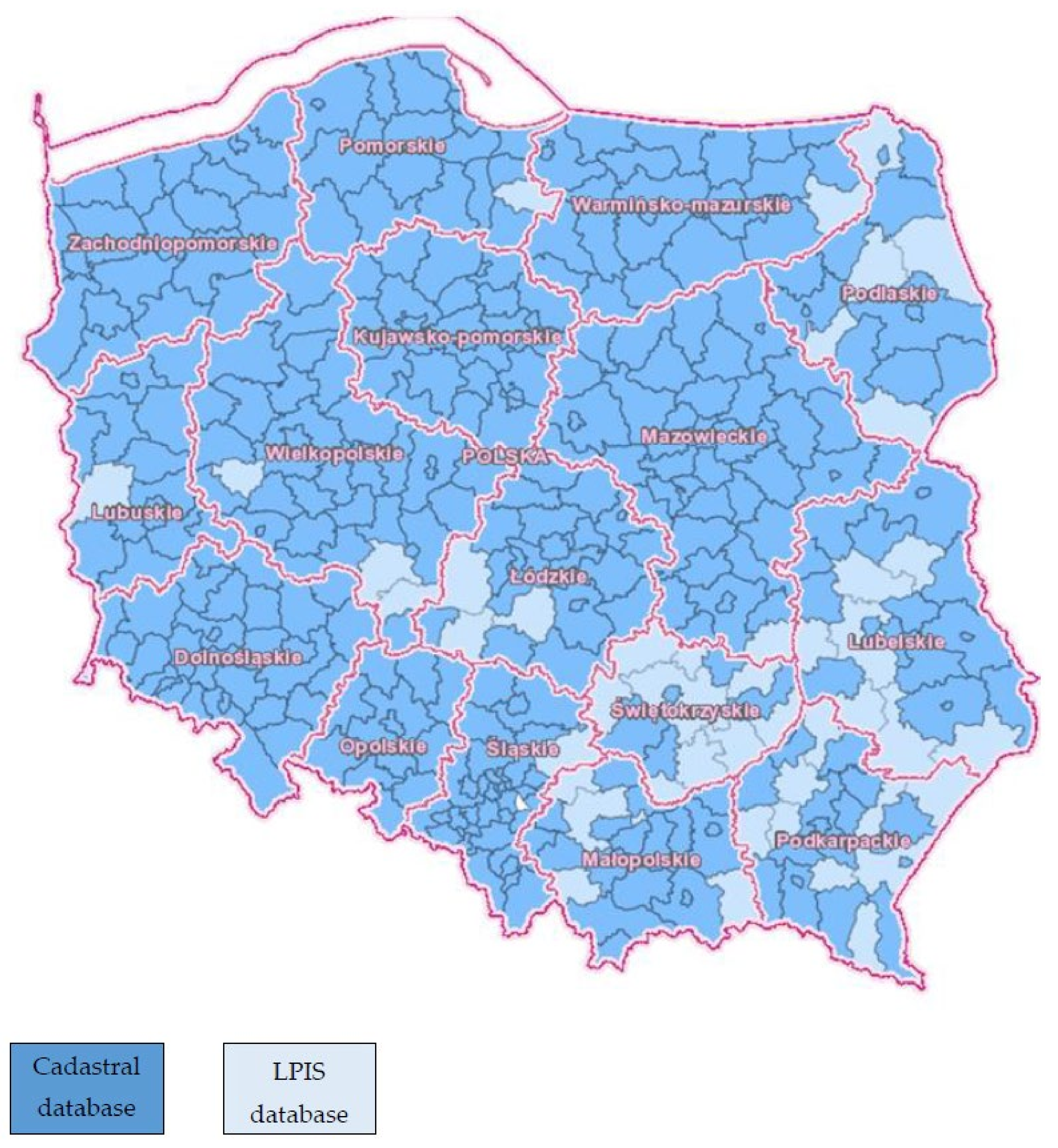
| E | Land and building register | E1 | 0—LPIS 1—Cadastral database |
| Diagnostic Criterion | Indicator | Symbol | Validity (0–1) |
|---|---|---|---|
| F | GetMap function | F1 | 0–1 |
GetFeatureInfo function *:
| F2 | ||
GetCapabilities function *:
| F3 | ||
| HTTP protocol | F4 | ||
| GetFeature function based on parcel ID | F5 | ||
| Function based on x and y coordinates | F6 |
| Diagnostic Criterion | Indicator | Symbol | Validity (0–1) |
|---|---|---|---|
| G | Date of last cadastral data update | G1 | 0—No date 1—Date of last update |
| Diagnostic Criterion | Indicator | Cadastral Database (CD) | Fulfilment of Criterion (Counties) | Fulfilment of Criterion (Voivodeship) | |||||||||||||
|---|---|---|---|---|---|---|---|---|---|---|---|---|---|---|---|---|---|
| CD1 | CD2 | CD3 | CD4 | CD5 | CD6 | CD7 | CD8 | CD9 | CD10 | CD11 | CD12 | CD13 | CD14 | ||||
| Technical and legal identifiers | |||||||||||||||||
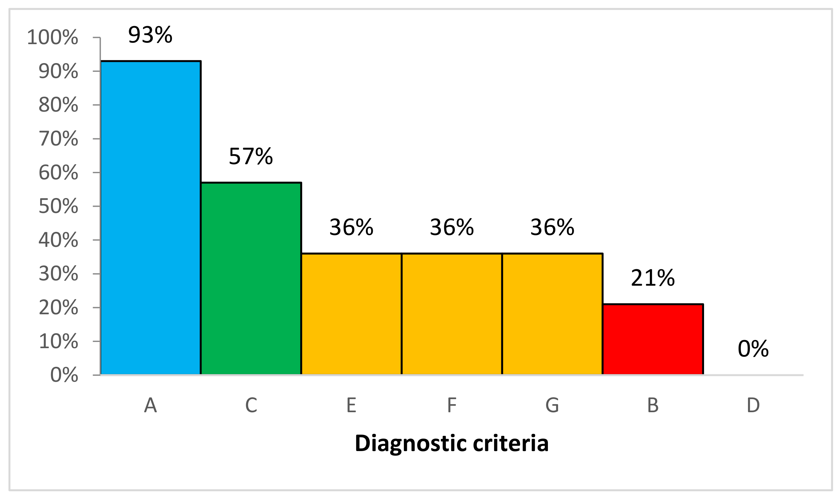
| A | A1 A2 A3 A4 A5 A6 A7 A8 | 1 | 1 | 1 | 1 | 1 | 1 | 1 | 1 | 1 | 1 | 1 | 1 | 1 | 0 | 93% | 93% |
| 1 | 1 | 1 | 1 | 1 | 1 | 1 | 1 | 1 | 1 | 1 | 1 | 1 | 0 | 93% | |||
| 1 | 1 | 1 | 1 | 1 | 1 | 1 | 1 | 1 | 1 | 1 | 1 | 1 | 0 | 93% | |||
| 1 | 1 | 1 | 1 | 1 | 1 | 1 | 1 | 1 | 1 | 1 | 1 | 1 | 0 | 93% | |||
| 1 | 1 | 1 | 1 | 1 | 1 | 1 | 1 | 1 | 1 | 1 | 1 | 1 | 0 | 93% | |||
| 1 | 1 | 1 | 1 | 1 | 1 | 1 | 1 | 1 | 1 | 1 | 1 | 1 | 0 | 93% | |||
| 1 | 1 | 1 | 1 | 1 | 1 | 1 | 1 | 1 | 1 | 1 | 1 | 1 | 0 | 93% | |||
| 1 | 1 | 1 | 1 | 1 | 1 | 1 | 1 | 1 | 1 | 1 | 1 | 1 | 0 | 93% | |||
| Diagnostic Criterion | Indicator | Cadastral Database (CD) | Fulfilment of Criterion (Counties) | Fulfilment of Criterion (Voivodeship) | |||||||||||||
|---|---|---|---|---|---|---|---|---|---|---|---|---|---|---|---|---|---|
| CD 1 | CD 2 | CD 3 | CD 4 | CD5 | CD6 | CD7 | CD8 | CD9 | CD10 | CD11 | CD 12 | CD 13 | CD 14 | ||||
| Cadastral data profile | |||||||||||||||||
| B | B1 B2 | 1 | 1 | 1 | 1 | 1 | 1 | 1 | 1 | 1 | 1 | 1 | 1 | 1 | 0 | 93% | 21% |
| 0 | 0 | 1 | 0 | 1 | 0 | 0 | 0 | 1 | 0 | 0 | 0 | 0 | 0 | 21% | |||
| Diagnostic Criterion | Indicator | Cadastral Database (CD) | Fulfilment of Criterion (Counties) | Fulfilment of Criterion (Voivodeship) | |||||||||||||
|---|---|---|---|---|---|---|---|---|---|---|---|---|---|---|---|---|---|
| CD 1 | CD 2 | CD 3 | CD4 | CD5 | CD6 | CD7 | CD8 | CD9 | CD10 | CD11 | CD12 | CD13 | CD14 | ||||
| WMS network service | |||||||||||||||||
| C | C1 C2 C3 | 1 | 1 | 1 | 1 | 1 | 0 | 1 | 1 | 1 | 0 | 0 | 1 | 0 | 0 | 64% | 57% |
| 1 | 1 | 1 | 1 | 1 | 0 | 1 | 1 | 0 | 0 | 0 | 1 | 0 | 0 | 57% | |||
| 1 | 1 | 1 | 1 | 1 | 0 | 1 | 1 | 1 | 0 | 0 | 1 | 0 | 0 | 64% | |||
| Diagnostic Criterion | Indicator | Cadastral Database (CD) | Fulfilment of Criterion (Counties) | Fulfilment of Criterion (Voivodeship) | |||||||||||||
|---|---|---|---|---|---|---|---|---|---|---|---|---|---|---|---|---|---|
| CD1 | CD2 | CD3 | CD4 | CD5 | CD6 | CD7 | CD8 | CD9 | CD10 | CD11 | CD12 | CD13 | CD14 | ||||
| WFS network service | |||||||||||||||||
| D | D1 D2 D3 | 0 | 0 | 0 | 0 | 0 | 0 | 0 | 0 | 0 | 0 | 0 | 0 | 0 | 0 | 0% | 0% |
| 0 | 0 | 0 | 0 | 0 | 0 | 0 | 0 | 0 | 0 | 0 | 0 | 0 | 0 | 0% | |||
| 0 | 0 | 0 | 0 | 0 | 0 | 0 | 0 | 0 | 0 | 0 | 0 | 0 | 0 | 0% | |||
| Diagnostic Criterion | Indicator | Cadastral Database (CD) | Fulfilment of Criterion (Counties) | Fulfilment of Criterion (Voivodeship) | |||||||||||||
|---|---|---|---|---|---|---|---|---|---|---|---|---|---|---|---|---|---|
| CD1 | CD2 | CD3 | CD4 | CD5 | CD6 | CD7 | CD8 | CD9 | CD10 | CD11 | CD12 | CD13 | CD14 | ||||
| Sources of data for databases of cadastral parcels and buildings | |||||||||||||||||
| E | E1 | 0 | 1 | 0 | 0 | 1 | 0 | 1 | 0 | 1 | 0 | 0 | 1 | 0 | 0 | 36% | 36% |
| Diagnostic Criterion | Indicator | Cadastral Database (CD) | Fulfilment of Criterion (Counties) | Fulfilment of Criterion (Voivodeship) | |||||||||||||
|---|---|---|---|---|---|---|---|---|---|---|---|---|---|---|---|---|---|
| CD1 | CD2 | CD3 | CD4 | CD5 | CD6 | CD7 | CD8 | CD9 | CD10 | CD11 | CD12 | CD13 | CD14 | ||||
| F | F1 F2 F3 F4 F5 F6 | 0 | 1 | 1 | 1 | 0 | 0 | 1 | 1 | 0 | 0 | 0 | 1 | 0 | 0 | 43% | 36% |
| 0 | 1 | 0 | 1 | 0 | 0 | 1 | 1 | 0 | 0 | 0 | 1 | 0 | 0 | 36% | |||
| 0 | 1 | 1 | 1 | 1 | 0 | 1 | 1 | 0 | 0 | 0 | 1 | 0 | 0 | 50% | |||
| 0 | 1 | 0 | 1 | 0 | 0 | 1 | 1 | 0 | 0 | 0 | 1 | 0 | 0 | 36% | |||
| 0 | 1 | 0 | 1 | 0 | 0 | 1 | 1 | 0 | 0 | 0 | 1 | 0 | 0 | 36% | |||
| 0 | 1 | 0 | 1 | 0 | 0 | 1 | 1 | 0 | 0 | 0 | 1 | 0 | 0 | 36% | |||
| Diagnostic Criterion | Indicator | Cadastral Database (CD) | Fulfilment of Criterion (Counties) | Fulfilment of Criterion (Voivodeship) | |||||||||||||
|---|---|---|---|---|---|---|---|---|---|---|---|---|---|---|---|---|---|
| CD1 | CD2 | CD3 | CD4 | CD5 | CD6 | CD7 | CD8 | CD9 | CD10 | CD11 | CD12 | CD13 | CD14 | ||||
| Data validity | |||||||||||||||||
| G | G1 | 0 | 1 | 0 | 1 | 0 | 0 | 1 | 1 | 0 | 0 | 0 | 1 | 0 | 0 | 36% | 36% |
© 2020 by the authors. Licensee MDPI, Basel, Switzerland. This article is an open access article distributed under the terms and conditions of the Creative Commons Attribution (CC BY) license (http://creativecommons.org/licenses/by/4.0/).
Share and Cite
Trystuła, A.; Dudzińska, M.; Źróbek, R. Evaluation of the Completeness of Spatial Data Infrastructure in the Context of Cadastral Data Sharing. Land 2020, 9, 272. https://doi.org/10.3390/land9080272
Trystuła A, Dudzińska M, Źróbek R. Evaluation of the Completeness of Spatial Data Infrastructure in the Context of Cadastral Data Sharing. Land. 2020; 9(8):272. https://doi.org/10.3390/land9080272
Chicago/Turabian StyleTrystuła, Agnieszka, Małgorzata Dudzińska, and Ryszard Źróbek. 2020. "Evaluation of the Completeness of Spatial Data Infrastructure in the Context of Cadastral Data Sharing" Land 9, no. 8: 272. https://doi.org/10.3390/land9080272
APA StyleTrystuła, A., Dudzińska, M., & Źróbek, R. (2020). Evaluation of the Completeness of Spatial Data Infrastructure in the Context of Cadastral Data Sharing. Land, 9(8), 272. https://doi.org/10.3390/land9080272