1. Introduction
Traditional seasonal settlements, intended for summer cattle grazing on mountain pastures, are widespread in the Mediterranean basin. In Western Balkans, they are called katuns (hereinafter: katun(s)) and, especially in Montenegro, have played an important role in its social and economic history. Due to the lack of arable land, the vast majority of Montenegrin population pursued the cattle rearing as the main agricultural and economic activity. On the other side, climate conditions, characterized by hot summers and droughts, determined that the food for cattle existed only on the abundant pastures on the slopes of numerous Montenegrin mountains. Having a possibility to establish katuns there, was the only way to create food supplies for winter and product surpluses for market, often meaning the sheer difference between survival and starvation.
This practice created a social and economic base for further growth and extension of Montenegrin villages—summer pastoralism in the mountains enabled the increase in cattle herds and sheep flocks, which prompted the search for larger pastures for winter and thus the movement towards the plains in the southern parts of the country. Rich and big villages in these areas have rarely been the primary source of creating katuns in the mountains, and since this process developed in an absolutely opposite direction, their establishment came out mostly as the result of the previous conquest of the vast pastures higher in the mountains. Such a development pattern lasted from early 15th to the middle of 20th century, becoming the most characteristic and widespread economic activity among the local population.
With social, economic and demographic changes in the Montenegrin society emerging after World War II—characterized by massive urbanization and industrialization—rural areas and katuns have lost their importance, with later almost fully disappearing as a prominent agricultural category. The most of them were abandoned, while remaining households predominantly consisted of elderly people, without visible intention of their heirs to continue such a lifestyle. Economic crisis—present in the region from the late eighties of 20th century—which forced into shutdown big industrial enterprises and caused a massive unemployment, forced some families to reconsider their decisions to abandon the traditional cattle rearing. There is a slow and scattered, but still visible return of some population in their late thirties and early forties to katuns for summer grazing, either with own or rented cattle and sheep. At the same time, more people are building their weekend cottages in the areas of traditional katuns. While it preserves the connection between people and mountain, it more than often devastates the traditional landscape through constructing objects using inappropriate materials, at inappropriate places and in traditionally inappropriate sizes and styles.
Accordingly, the current domain of topics related to Montenegrin katuns includes their historical background, economic trends and perspectives, environmental and landscape qualities and characteristics—as well as the sphere of cultural heritage and its protection and valorization. Here, these categories interact, creating a whole where the dimensions and construction of mountain cottages fully represent economic and social status and perspective of the dwellers, fitting into the natural landscape as an almost organic part. These constructions—as the incarnations of the same driving forces all over the Mediterranean basin—display the universality of human responses to the natural and social challenges, showing a high degree of matching among the areas in the Adriatic background and, let’s say, the Western Alps [
1]
Unfortunately, the katuns in the region of Montenegro—including ones at the Kuči Mountain as well—have not yet been sufficiently researched and valued from the aspect of the protection of cultural heritage, although as seasonal mountain settlements, they represent a significant segment. Cultural heritage ‘includes all aspects of the environment resulting from the interaction between people and places through time’ [
2], the cultural landscape is the widest and most comprehensive category of cultural heritage—the common work of nature and mankind. Such permeation is clearly visible in traditional katuns of the area, where every anthropogenic organizational, architectural and constructional action follows the postulates of understanding the surrounding nature, being it protection of wolves, preservation of pastures and use of water sources or utilization of terrain geomorphology.
It is assumed that the term ‘katun‘ has been used for shepherds’ village since the 13th century [
3] (p. 113). In different researchers’ works, katuns are defined as ‘summer villages in the mountains’ [
4] (p. 366), ‘summer abodes’ [
5] (p. 4), ‘summer flats’ [
4] (p. 78), ‘temporary summer flats’ [
6] (p. 8), ‘an entire temporary summer livestock farmers’ settlement’ [
7] (p. 235) or ‘groups of cabins of wood on summer pastures’ [
3] (p. 113). In any case, these terms define the seasonal mountain settlements that are regularly visited by the same occupants every summer, rearing their sheep, cattle and horses to grazing at surrounding pastures.
The existing scientific and scholarly works have treated the thematic of katuns only through its place in a broader context of the life and history of Kuči, Montenegro and northern Albania. Among the authors, one should mention Marko Miljanov, Jovan Erdeljanović, Stevan Dučić, Marko Rašović, Vaso Čubrilović, Ivan Božić, Đurica Krstić, Ljubinka Bogetić-Ćirić et al. [
7,
8,
9,
10,
11,
12,
13,
14,
15]. An exception is the book of Novo Vujošević
Kučki katuni (
The Kuči Katuns) [
16], as the first of only few dedicated attempts of a thematic research on this issue [
16,
17,
18]. However, neither of them provided a full and precise inventory of katuns at the Kuči Mountain, their exact locations and number, condition, type and description of belonging structures, approach roads, availability and type of water supply infrastructure and many other things. While the seasonal mountain settlements in Alps were the topic of many interesting investigations [
19], katuns in the background of the Adriatic remained out of social and scientific focus.
For all this, our research was aimed to contribute to more precise describing heritage values of the katuns in case study area, trying to list and quantify all the important categories of the visible objects. Their sheer number testifies on their importance in social life until the late 20th century, so the lack of basic data on their organization, disposition, structures and subsidiary objects, greatly impedes the growth of knowledge on this topic. We expected that—according to obtained figures on katuns and subsidiary objects—we will be able to determine more precisely the intensity of this social and economic way of life at the Kuči Mountain, as well as to establish similar correlation for the other Montenegrin and Balkan’s mountain regions. Existing data—acquired through archival investigations, consulting literature and interviewing locals—implied that there may be found up to 120 katuns on a mountain. The fact that the final number reached almost twice figure, also meant that the general importance of katuns in the life of the local population was greatly underestimated.
Knowing that this area was just the one among many similar in the Dinaric mountain chain, one of the research goals was to promote and encourage further similar scientific endeavors. This research, with all its limits and deficiencies, was the first of the kind in decades in Montenegro. One of its purposes was to bring katuns back on the map of scientific topics, as well as to push relevant stakeholders at governmental and non-governmental levels to take necessary steps for putting katuns and transhumance on the national list of protected intangible cultural heritage. It is also worth noting that the transhumance in matching pastoral areas of the Alps, the Apennines and Greece, have already been inscribed in 2019 on the Representative list of the intangible cultural heritage of humanity [
20], along with traditional techniques of drystone walling inscribed a year before [
21].
2. Materials and Methods
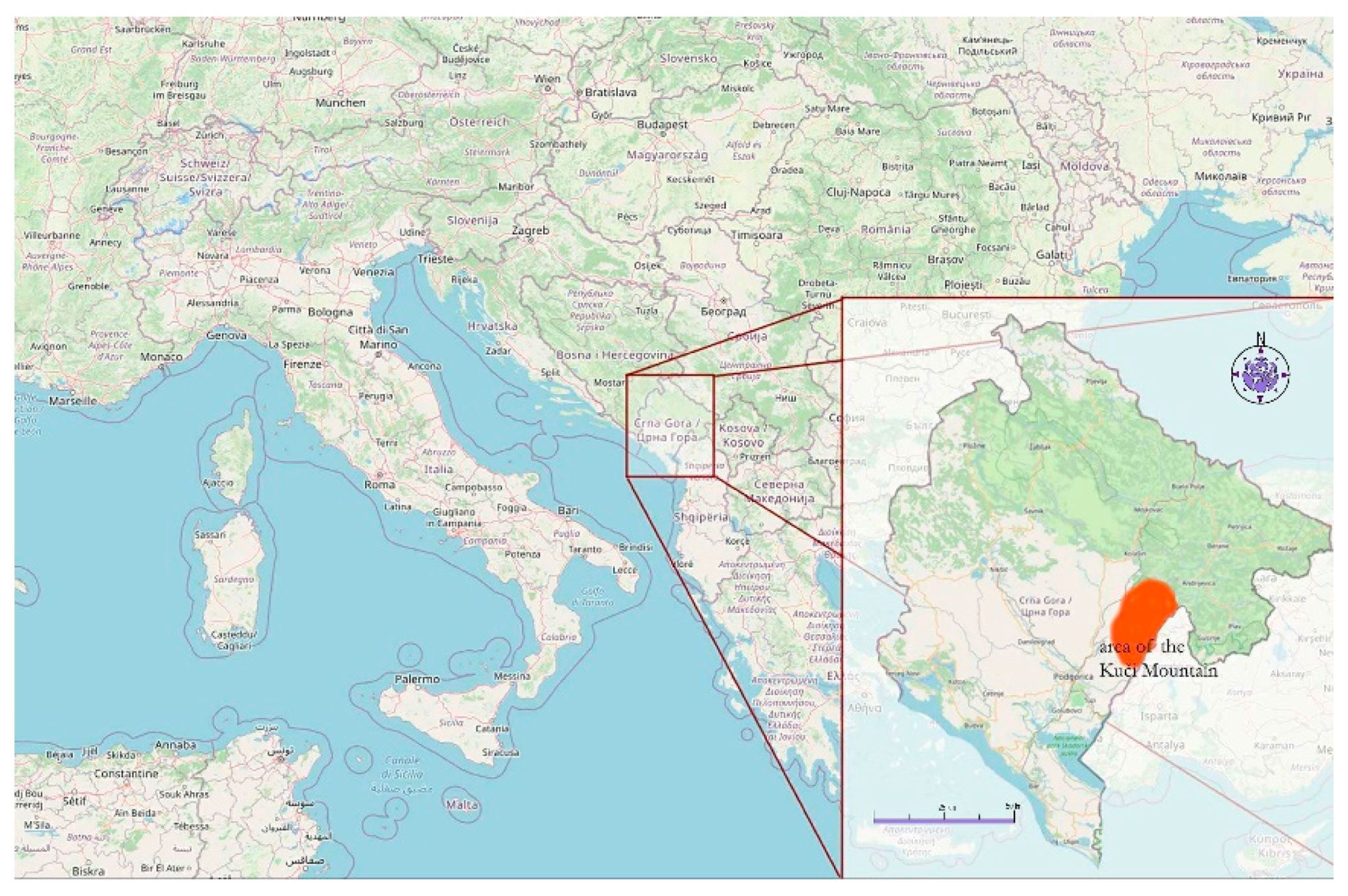
The Kuči Mountain territory belongs to the chain of the Southeastern Dinarides. The region has a surface area of about 220 km
2, northeast of Podgorica, comprising of the mountain range of Žijevo, the southern part of Komovi and the western part of the Prokletije massif (
Figure 1). The local climate is characterized as a humid, warm temperate climate type (moderately Cf), represented by subtypes Cfb and Cfws’’bx” in the southwestern part of the region, and cold and humid climate (Df), represented by subtype Dfbx”, in the northeastern parts [
22]. The southwestern region is built of solid chalk limestone and of the Triassic limestone, mixed with dolomites and dolomitic limestone. In the northeastern sector, the limestone is often interrupted with silicate rocks—the Upper Cretaceous flish— better known in literature as the
Durmitor flish [
23].
In this respect, a tradition of seminomadic (katun) livestock farming developed, which for a long time was the basic economic activity of the local population at the Kuči. The richness of mountain pastures enabled summer grazing of livestock, providing both reserves of food for winter and surpluses for sale on the market.
Believing that determining basic quantitative characteristics of the region is one of the prerequisites for its development, through the project
Valorization of Montenegrin katuns and sustainable development of agriculture and tourism—KATUN [
24], an attempt was made for the first inventory of the architectural heritage of the Kuči Mountain, to determine as accurately as possible the number of katuns and their locations, as well as types and conditions of structures within them. Desk and field investigations on this topic were conducted in the period of July 2015–November 2017. The methodology of the research itself started from collecting information available in the existing literature, through the conversation with the inhabitants of the Kuči and a study of printed and electronic cartographic material. The Google Earth online service was of particular importance, enabling us to determine the exact locations of katun settlements—even in the areas for which neither written data existed, nor their existence remained in the knowledge or memory of the people interviewed for the needs of this research.
It should be noted that this research covered only the katuns built of solid material, and whose remnants are still visible. We are aware of the fact that methods of cattle-rearing originates from the distant past in this area, but the non-existence of relevant archaeological surveys forces us to limit our research focus only to locations where the objects were built in stonemasonry techniques, allowing them to fully or partially survive to this day. Since the use of stone for wall construction in this area started only in the second half of 19th century, the chronological frame of research covers the period of the last ca. 150 years.
Considering the number of katuns in the researched region—and lack of relevant data in the available printed and electronic literature—the determination of the factual state required a large number of field trips to previously known localities, as well as to those found after a thorough study of the terrain image on Google Earth. This is especially important to emphasize for those katuns on which there is no other information, and which would certainly remain unnoticed without the use of this contemporary navigational aid. The approach to the localities varied from a simple approach along an asphalt road, to the use of a 4WD vehicle along the tough mountain roads, to several-hour walks up mountain trails and paths. Every katun, however, was personally approached and all data with following photo documentation, referring either to the katun itself or to individual traditional dwellings—gladas (huts, hereinafter glada(s)), were taken on site.
The subject of the research was all parts of the Kuči Mountain where katuns was established. Considering that the construction of structures of hard material in this region spread only in the mid-19th century, the research was also limited only to those areas where it was possible to find visible material remains of katun structures. In the katuns that entirely or predominantly kept their traditional character, the inventory of all the existing structures—regardless of their origin, age or the context of construction—was conducted.
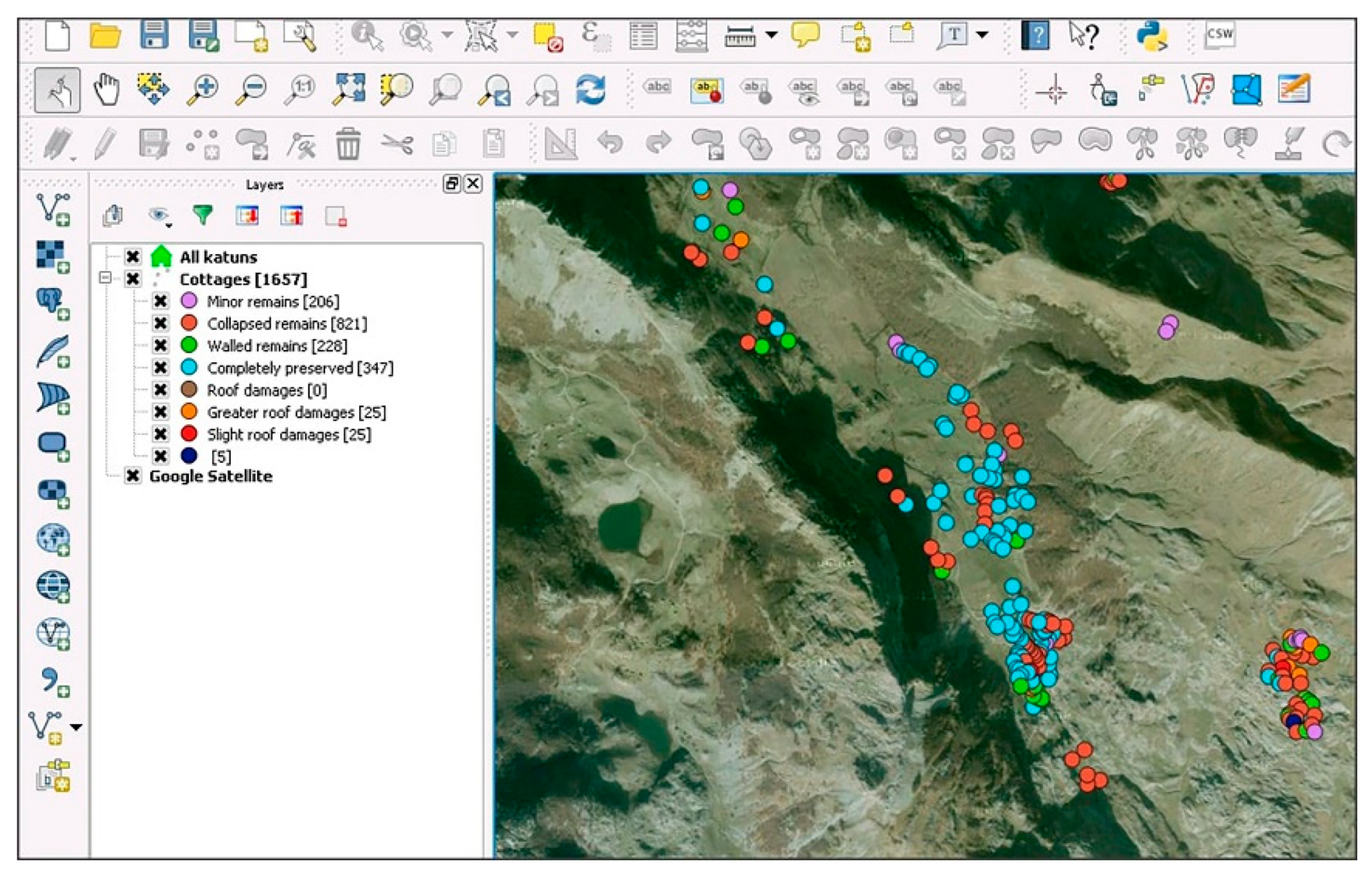
Google Earth satellite imagery and topographical maps were used as an essential data entry base. The above-mentioned maps were used first for fieldwork and the identification of all locations, and then for data entry as well. Very important information was recorded during the conversations with people, who still move up to the katuns with their family members, livestock and movable property. During the research, project team members took a host of photographs, architectural sketches and videos of the existing structures and visible remnants. Tables with additional information were filled for every katun on site and then moved into the working version of the database. This first database of Montenegrin katuns was created in QGIS 2.8.3. The aforementioned register is still not available online, but it is planned to post at least some of its parts as an open information source. The mentioned database maps not only settlements, but also any built structures, i.e., different kinds of wooden or stone architectural structures (
Figure 2 and
Figure 3).
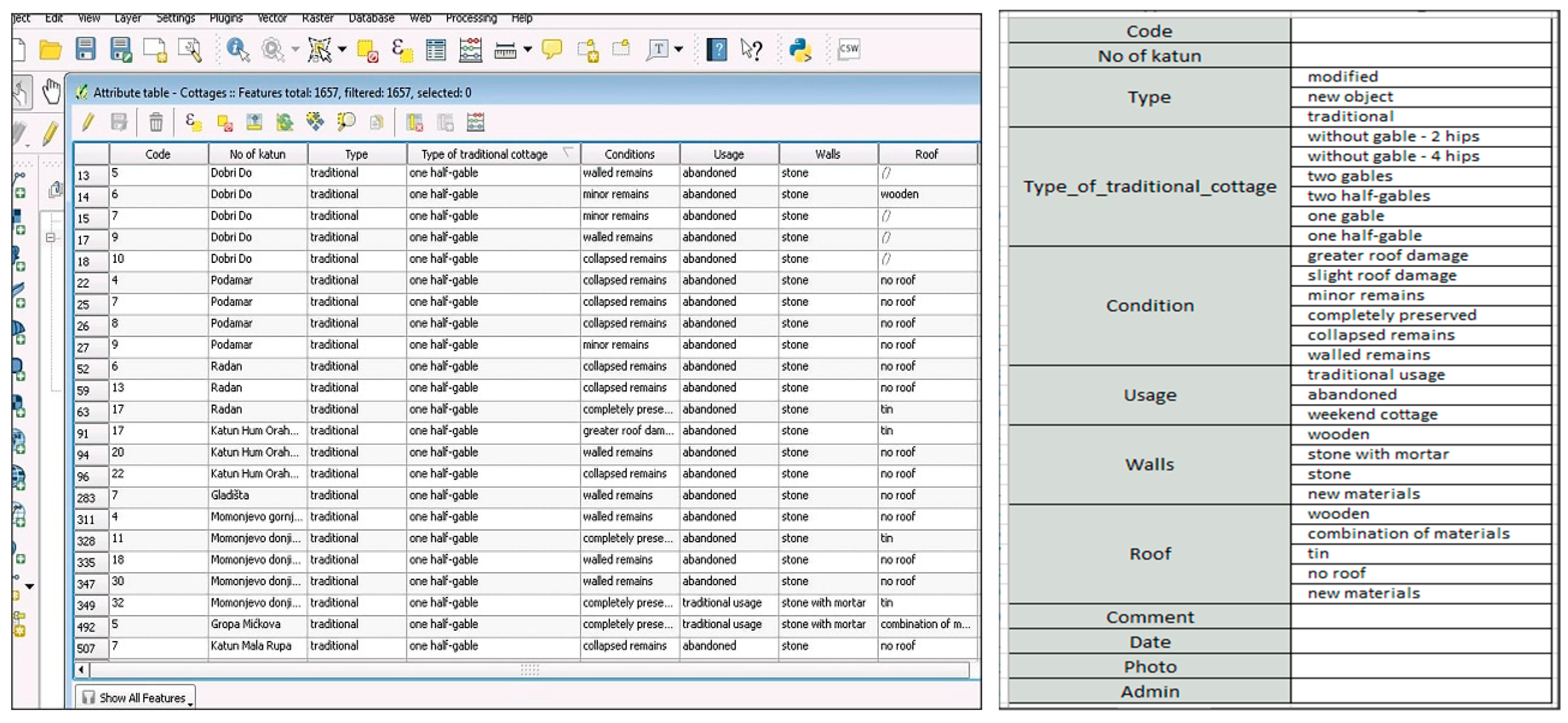
Files of katuns and gladas—containing characteristic descriptive categories—were composed for the need of the research. The condition of each glada was additionally described through an auxiliary information sheet (attribute table) referring to the state of preservation of structure, types of material for walls construction, roof styles and front wall forms, as well as additional information on structure purpose (
Figure 4).
The data on katuns were arranged in a simple and comprehensible form. It contained an identical type of information for all katuns, such as name, geographic coordinates, elevation, belonging, state of population, number, type and current state of structures, as well as descriptions of transport, water supplies and electrical infrastructure belonging to them. Geographic coordinates were given according to a particular point within the katun itself and they match the format used by Google Earth, while the elevation was given singly, according to an average (if it was a katun on flat terrain or in the cirque) or in a range, when a katun on the slope was in consideration. The data on 193 katuns and over 2900 gladas were collected and entered into a database in one vector layer [
25].
3. Results
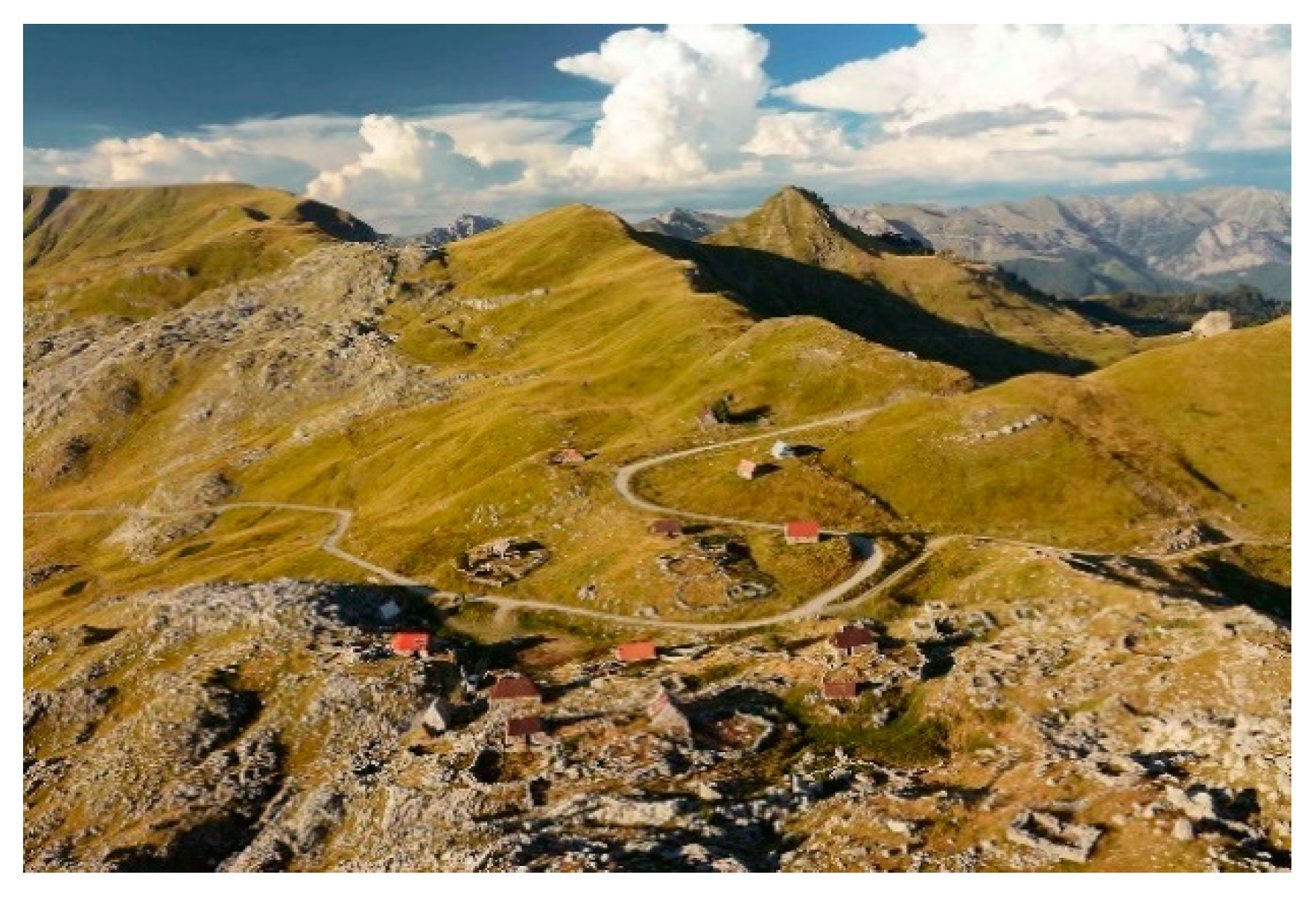
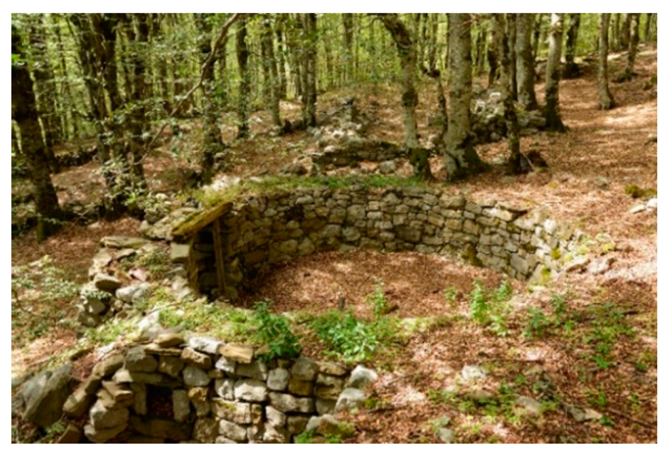
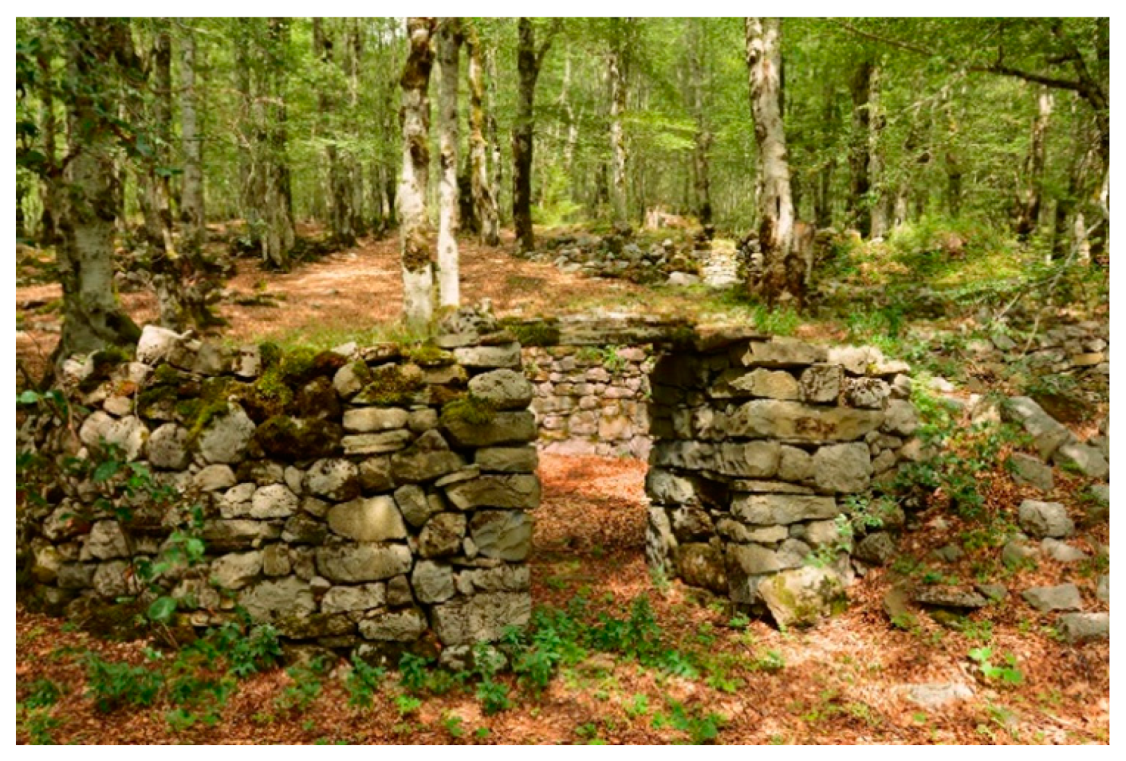
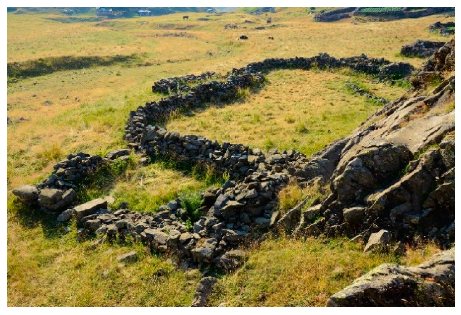
The research determined that on the mountain there were 193 katuns, 59 of which were permanently inhabited, and around twenty more were occasionally inhabited. According to their position, katuns at the Kuči Mountain can be divided into katuns on the slope, in the cirque and in the forest (
Figure 5,
Figure 6,
Figure 7 and
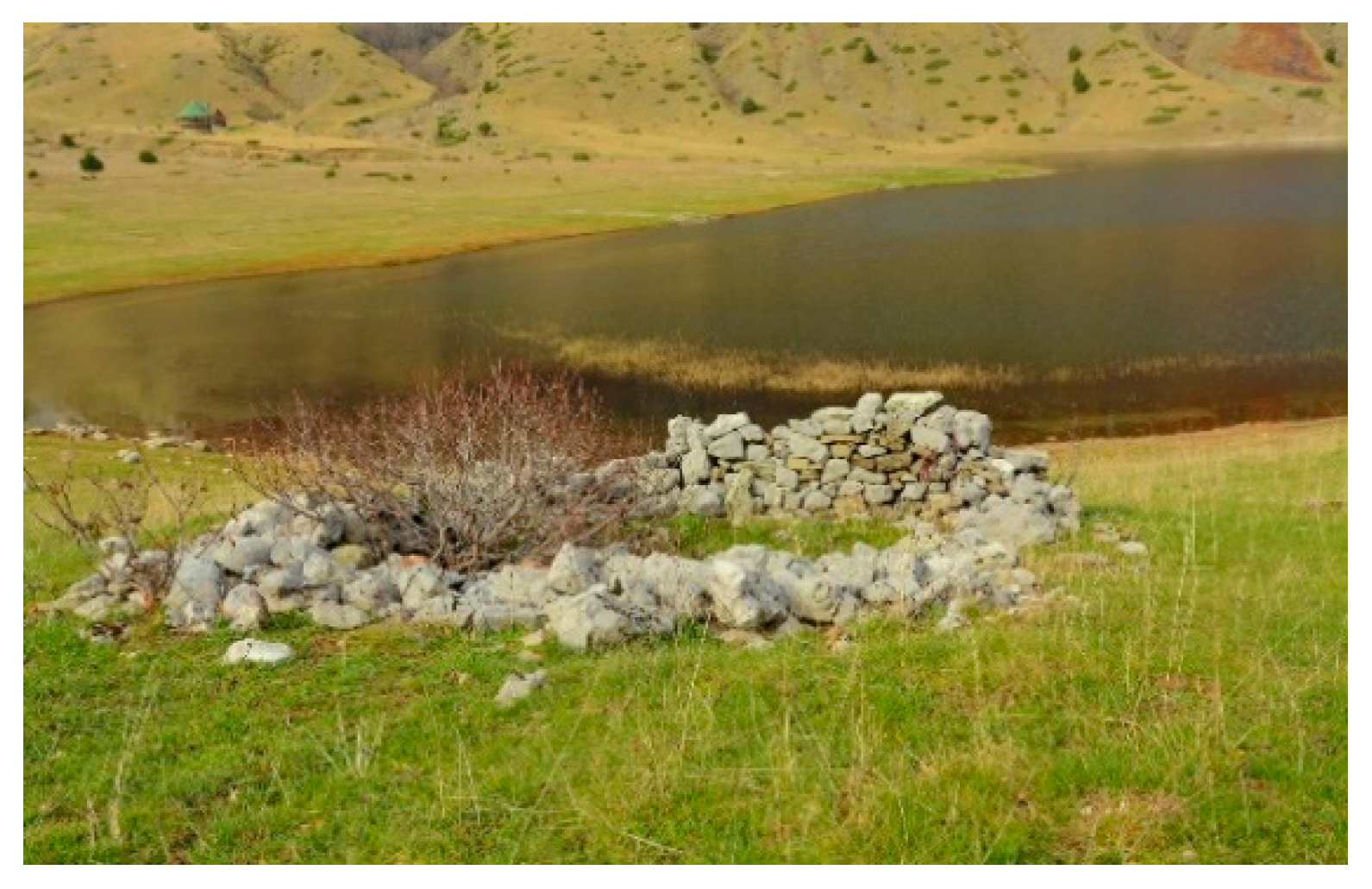
Figure 8). The largest number of katuns is situated on the mountain slopes. They are located in pastures zone, above the forest zone and below the zone of rocky mountain peaks. Besides the katuns on the slopes, one often comes across the katuns in cirques, particularly in the southern, karstic part of the Kuči Mountain. Katuns in the forests are rather rare. In most cases, they were built at forests edges or clearings within the forests. In some cases, due to a neglect and disuse of the mountain, forest expanded and comprised katuns as well. Since the position of katuns also depends very much on the availability of water, in regions in which there is water, they are located next to springs, brooks, puddles or lakes, while in arid regions, katuns are situated in the vicinity of snow sinkholes.
On the katuns situated on the slope, gladas with corrals were most commonly built longitudinally, parallel to the contours of the terrain, immediately below the lower or above the upper forest edge. The katuns in the cirques are organized similarly as villages in such cases, in a way that the natural advantages of the terrain were used to the maximum. Gladas with pens are most commonly positioned along the edge of the cirque or on smaller hillocks if there were some in the cirque, while flat surfaces covered with pastures were left free. When in a particular location, in hollows, cirques or around lakes there were minor hillocks, gladas and pens grouped around them. In the katuns lower down the mountain, next to gladas and pens, arable surfaces appear as well [
4] (p. 79).
Altitudinal distribution of the katuns ranges within ca. 700 m of altitude, from 1154 to 1879 m. This pattern depends on the projected use of katun, where the ones at lower altitudes were used mostly earlier in the summer (until late July). After the pastures in the area were exhausted by grazing and summer drought, the shepherds would have moved up to the higher katuns with enough grass for their cattle. This two-staged transhumance was the privilege of wealthier and stronger clans and communities, who could afford possession of two katuns. Most the others had to establish their katuns somewhere in the middle, at altitudes ranging from 1300 to 1600 m and to spend all the summer there.
The other decisive factor was the water supply. The area of the Kuči Mountain consists of two different types of bedrock that determine the appearance of water springs. The limestone in southwestern region is very water porous, hence there are only few springs in the whole area. The main sources of water here are the caves where snow remained until summer. In the northeastern sector, the bedrock is made of flish with many water springs. Here, the katuns were mostly located above the upper forest line (above ca. 1700 m). The middle part of the mountain—characterized by mixture of these two zones—has the moderate amount of water springs, but two glacier lakes enabled formation of many katuns in their vicinity [
26].
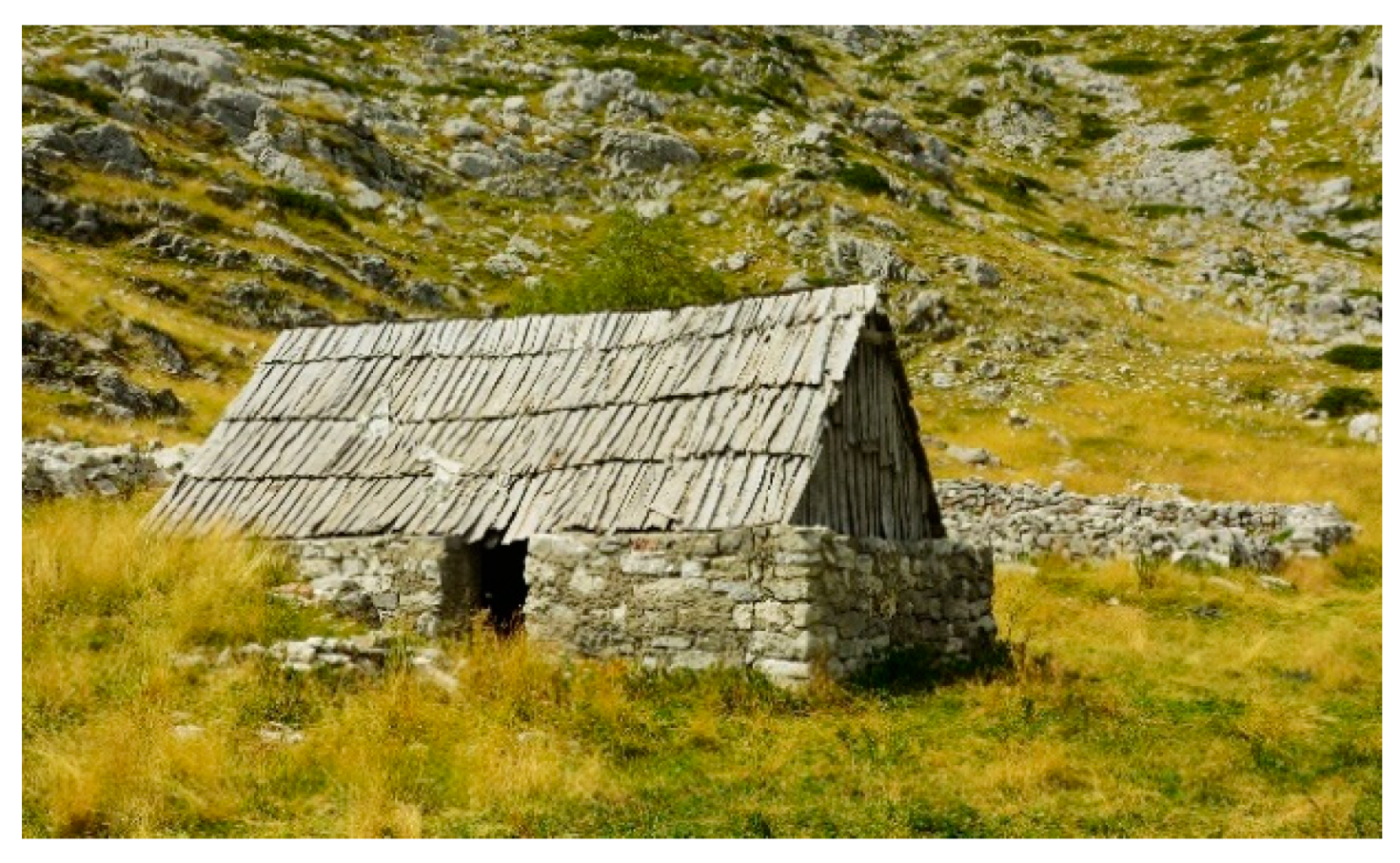
3.1. Cabins/Gladas
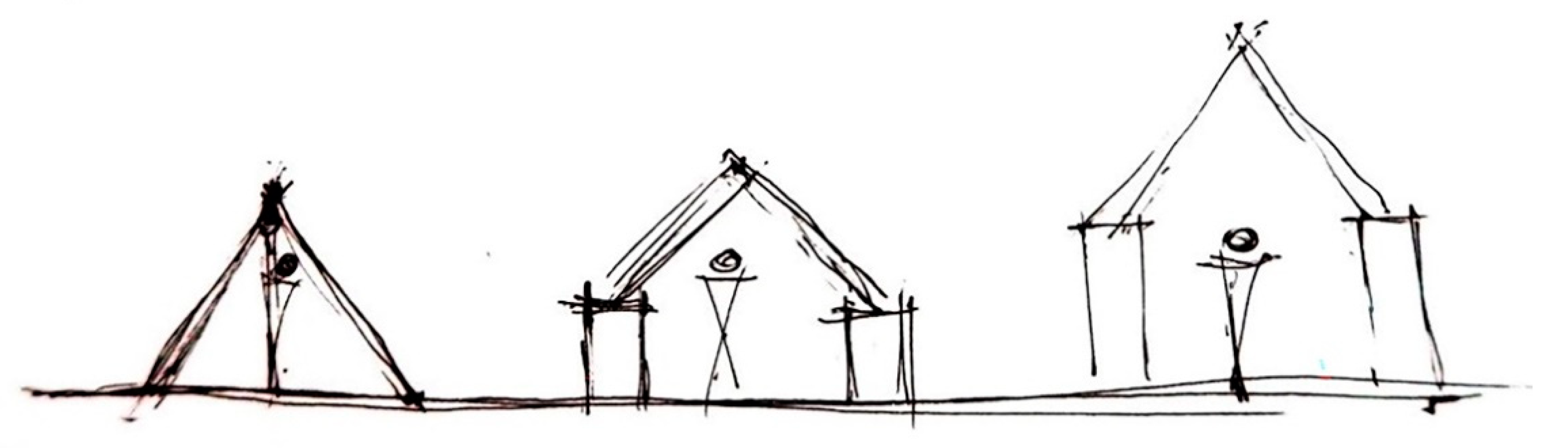
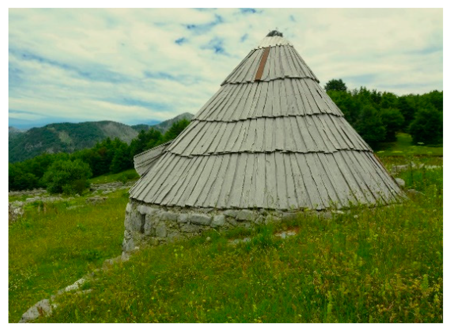
The traditional mountain cabin—the shepherd’s dwelling called glada in the Kuči area—is the most important segment of architectural heritage of katuns of the Kuči Mountain. Although representing the simplest form of dwellings, their types developed and changed over the time. The oldest and the simplest ones had only a roof starting straight from the ground. It may have been made above a circular or rectangular plan, with a simple construction of logs and different kinds of cover—
krovina (roofing) from available materials. The most widespread forms among those simplest forms of cabins—particularly in forested regions—were cabins of a circular plan, with the hearth in the middle, covered with the roof in the shape of a cone. In Montenegro, including the region of the Kuči Mountain, this type of cabin is most frequently called
dubirog (hereinafter dubirog(s)), while in the northern part of the country, the name
savardak—a Turkish name derived from the word denoting a roll or a (firearm) cartridge [
6] (p. 12), is also used for the same object. For the Kuči region, there are data that the original cabins were covered with cloth/canvas from goat’s hair, and then with straw as well.
It looked like a big nomadic tent, having a ridge fixed on the poles, over which, on both sides, a large and wide piece of pustina (cloth) was tightened around all its four sides and fastened to the ground. It could have also been broken down, loaded onto the horse and that way moved from place-to-place.
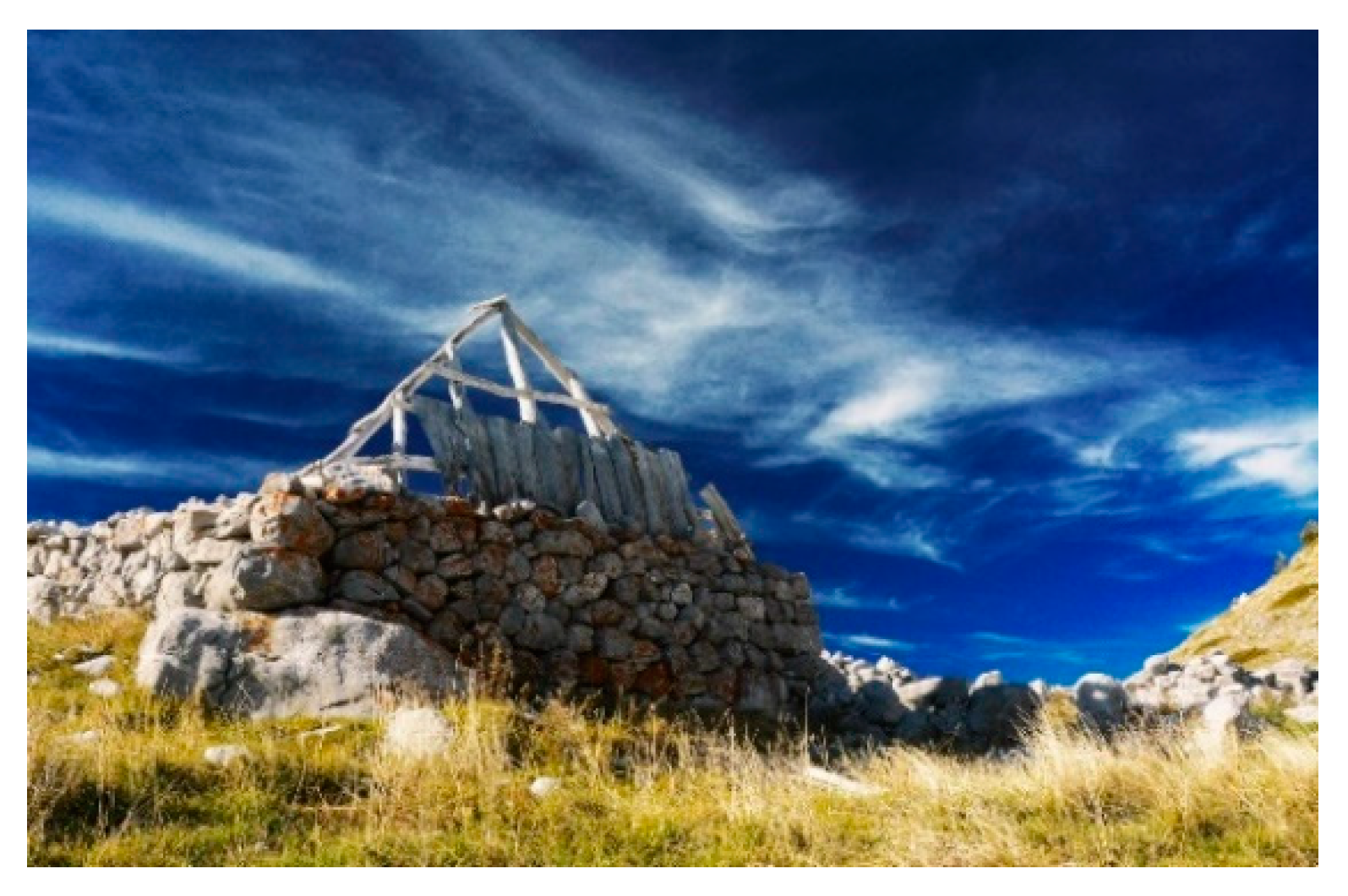
Later, more complex types developed, in which in the base received a wall of stone made in the drystone wall technique, onto which a roof construction and a roof were laid. Over time, they also changed and developed, resulting in several different kinds—depending on the size and form of the plan, the wall height, materials and building techniques (
Figure 9).
At Kuči Mountain, remains of older, simpler types of cabins that did not have any walls of stone, but only a roof with a wooden roof construction, were not preserved. We know about them only from literature. Only the remains of more complex, newer types of cabins—with stone walls, roof constructions above them and circular and rectangular plan—have survived to these days.
3.1.1. Types of Cabins
The gladas with a rectangular plan are the most prevalent types of traditional cabins at the Kuči Mountain, while dubirogs—the cabins of a circular plan—occur in a considerably smaller number. During the field research, ca. 2600 traditional and modified gladas in total were identified, almost all of which were of a rectangular plan and only some twenty dubirogs. In comparison to the simplest type of dubirog, which consists of a roof in the shape of a cone only, the more developed form features a small circular wall, made of crushed stone, without a bonding agent, ‘in dry’, on which a wooden construction for the roof in the shape of a cone was laid (
Figure 10).
At the beginning of the 20th century, Jovan Erdeljanović described the dubirogs at the Kuči Mountain in the area of Komovi, while Antonio Baldacci, an Italian biologist, did the same in the region of the Mokra in 1902. They both assumed that the Kuči modeled them according to pattern that existed in the neighboring Montenegrin tribes [
27] (p. 788). In this period, some dubirogs in the region of Korita were covered with turfs and were known as ‘
busare (turf huts)’ [
5] (p. 79).
Similar to the gladas of the rectangular form, the dubirogs were most commonly built on gently sloped terrain, on the rear side partially dug into the terrain. The opening for the door was situated on the lower side, down the slope. In most preserved ones, the interior diameter ranges from 4.50 to 5.60 m, and a smaller number of them has a diameter of about 3.60 m. The walls of dubirog—similar to the walls of rectangular gladas—were built of stone in the drystone wall technique, with two faces of larger blocks and smaller rubbles. The thickness of such walls varies, ranging from the 60 cm (although rather rarely) to a maximal 140 cm. Often, the width of walls within the same dubirog varied in different segments. The height of its walls was approximately around 120 cm, while the highest wall measured was 155 cm high.
The opening for the door in the stone walls of dubirog is most commonly about 100 cm wide. It is often narrower towards the interior, from 70 to 80 cm, and it widens in a trapezium shape towards outside, up to 100–110 cm. In the semicircular walls of dubirog, as well as in the walls of rectangular gladas, on the interior side, the niches serving as shelves can be found (
Figure 11 and
Figure 12).
In several locations (Javorci, Stružica, Velji do) within the complex, next to gladas, there are smaller dubirogs as well, with an interior diameter of 2.5–3 m, which are assumed to have served as subsidiary objects. Although dubirogs were simpler for construction, it is supposed that due to the circular plan, they were less suitable to the needs of the interior organization of space, and therefore they were superseded by gladas with rectangular plan, which become the dominant type of structure at the mountains.
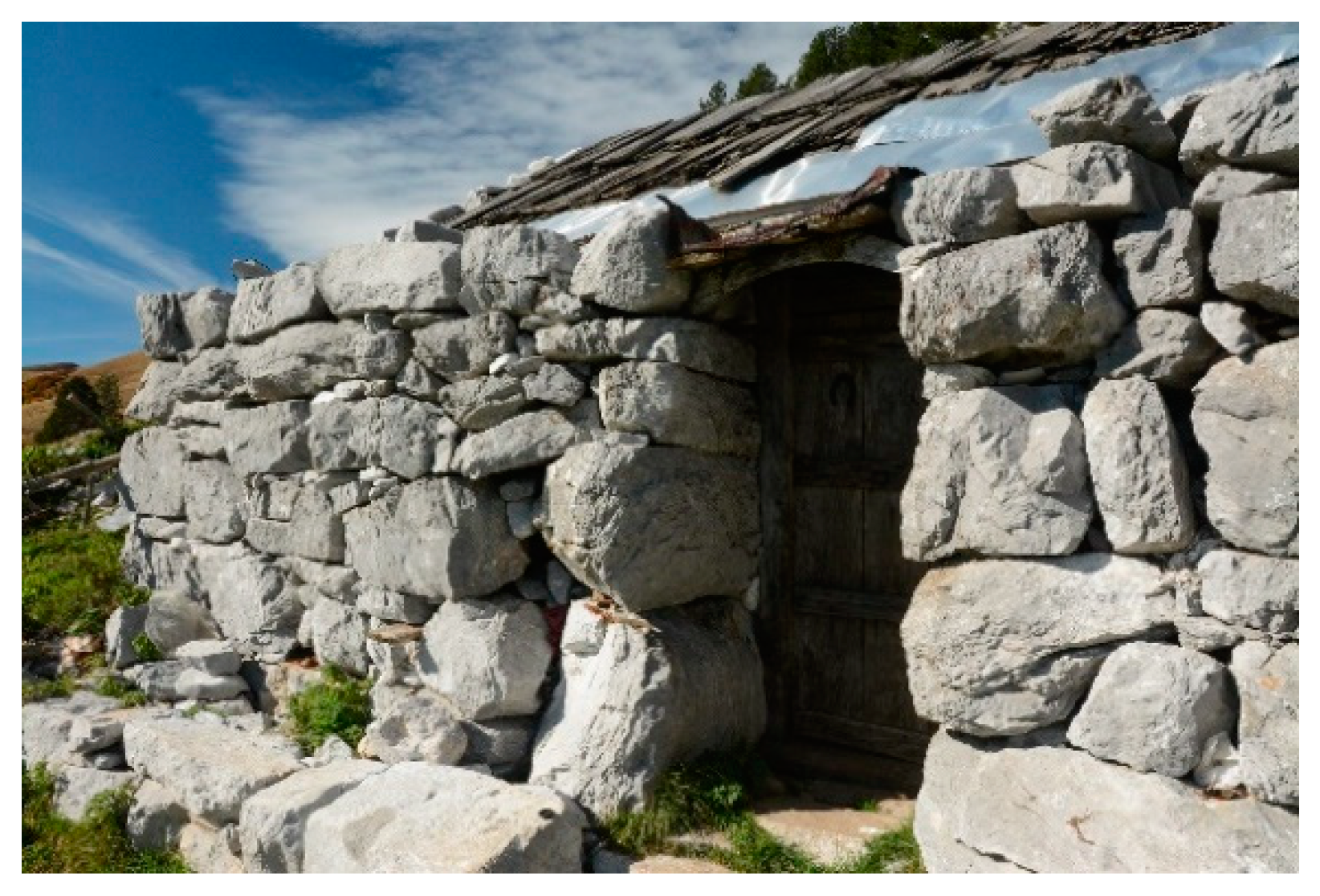
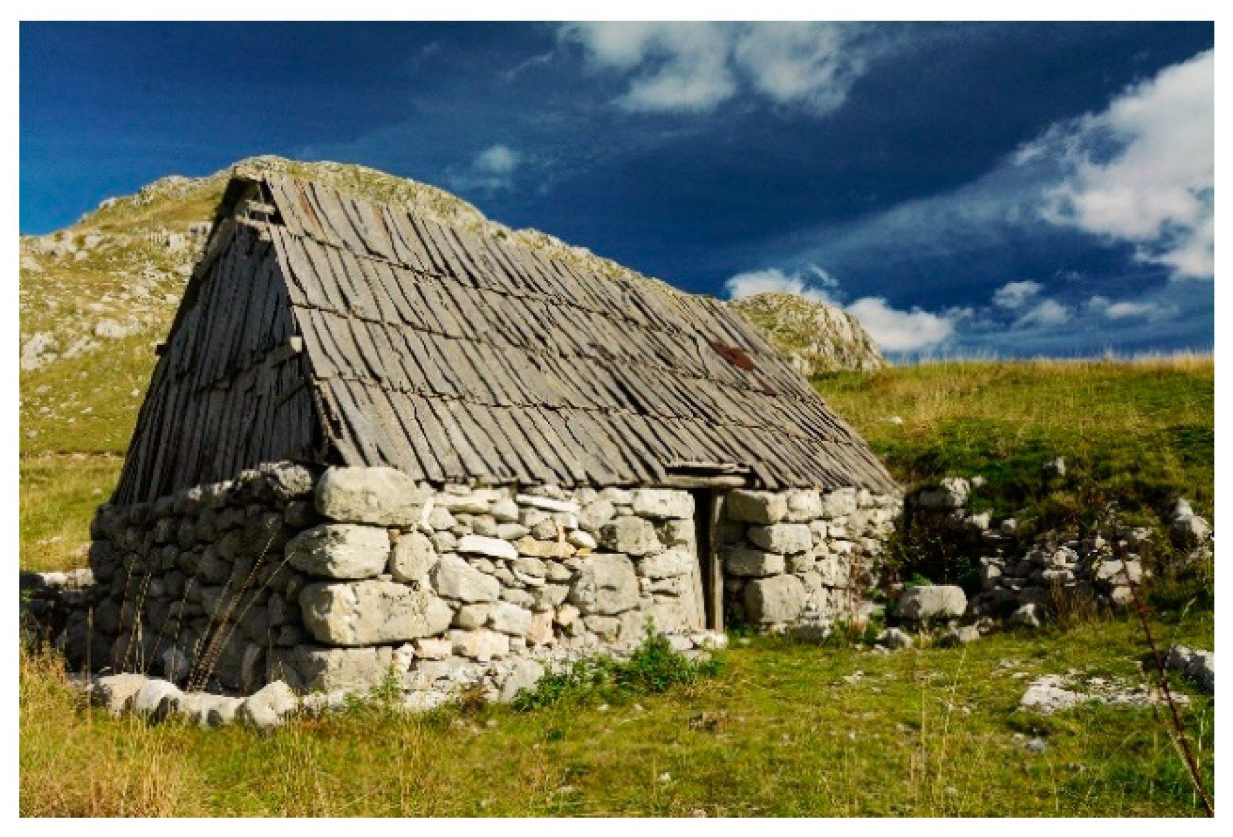
Traditional gladas—as the most common type of cabins on the Kuči Mountain—are the structures of an elongated rectangular plan, built of stone in the drystone wall technique, with the wooden roof construction and the gable roof or the hipped roof, originally covered with straw or wood. These gladas are very similar to the simplest forms of houses which the Kuči built in the villages,
‘suhozadice (drystone wall houses)’ or ‘
slamnjače (thatched houses)’ [
5] (p. 81), which were without windows and covered most commonly with straw.
Houses in the Kuči villages were, like gladas, also of an elongated, rectangular plan. In houses, the longer walls are called
rebra (literally translated ‘ribs’) and the shorter, side ones,
listras. One of the long walls, on which there was the entrance, is called ‘face’, and the other long wall is called rear face’. Often on drystone wall houses, gables were not erected, but the side walls remain level with the long walls, so the ‘hipped roof‘ is made. The wall of this kind of house is a drystone wall, so, basically, gladas in katuns follow this constructional pattern. The gladas on the Kuči Mountain were first described in this manner at the beginning of the 20th century by Jovan Erdeljanović [
7] (p. 236), [
27] (p. 697).
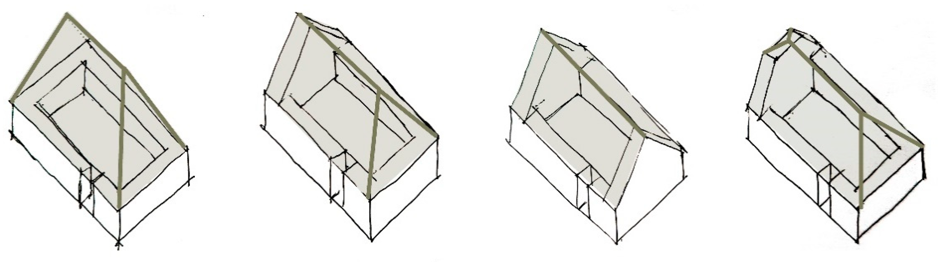
Gladas can be divided into different types according to the shape of sidewalls, which determined the roof shapes as well. The classic sidewall was higher than the face of the structure, and in the upper section, it finished with a stonework triangular ending in the form of a gable. The sidewalls of gladas can also be completely leveled, i.e., at the same height as the long walls of the front and rear face of the house. In that case, by means of a wooden construction, the hipped roof or more commonly the gable roof can be formed, and in some cases even the one with three slopes. We often come across the examples of gladas on which one of the sidewalls is with a stonework triangular ending—the gable, while the other is at the same level with the long walls. In these cases, the roof can be called “gable roof” or “three-pitched roof” (
Figure 13).
There are some gladas with sidewalls representing a transitional form between gable walls and leveled sidewalls, so-called ‘half-gable walls’. On them, the triangular ending of the gable was cut out, therefore that upper section of the side wall is in the shape of a trapezium. In this case, the roof above the ‘half-gable wall’ was cut out and it represents a transitional shape between gable roof and three-pitched roof. ‘Half-gable walls’ are mainly found on one side only (there are only several cases of gladas with two half-gable walls), and that is the one which is oriented towards the hill, in the case when a glada is partially dug into the terrain.
Based on data from the terrain—as well as notes of explorers of the area of Kuči at the beginning of the 20th century—it may be concluded that in the katuns of the Kuči Mountain, there were two kinds of gladas, with lower and higher roofs. In the area of the Upper Mountain, gladas with shorter roofs prevail, having either stonework gable walls or leveled sidewalls. The height of the sidewall, i.e., the height of the roof was determined by the availability of timber for roof construction and the roof cover. In the Lower Mountain, gladas with long walls and sidewalls at the same height and with much higher hipped or gable roofs with wooden constructions and the cover of straw or wood were common. With the passing of time, the type with higher roof became the standard all over the area.
3.1.2. Basic Characteristics of Gladas, Position in Relation to the Terrain
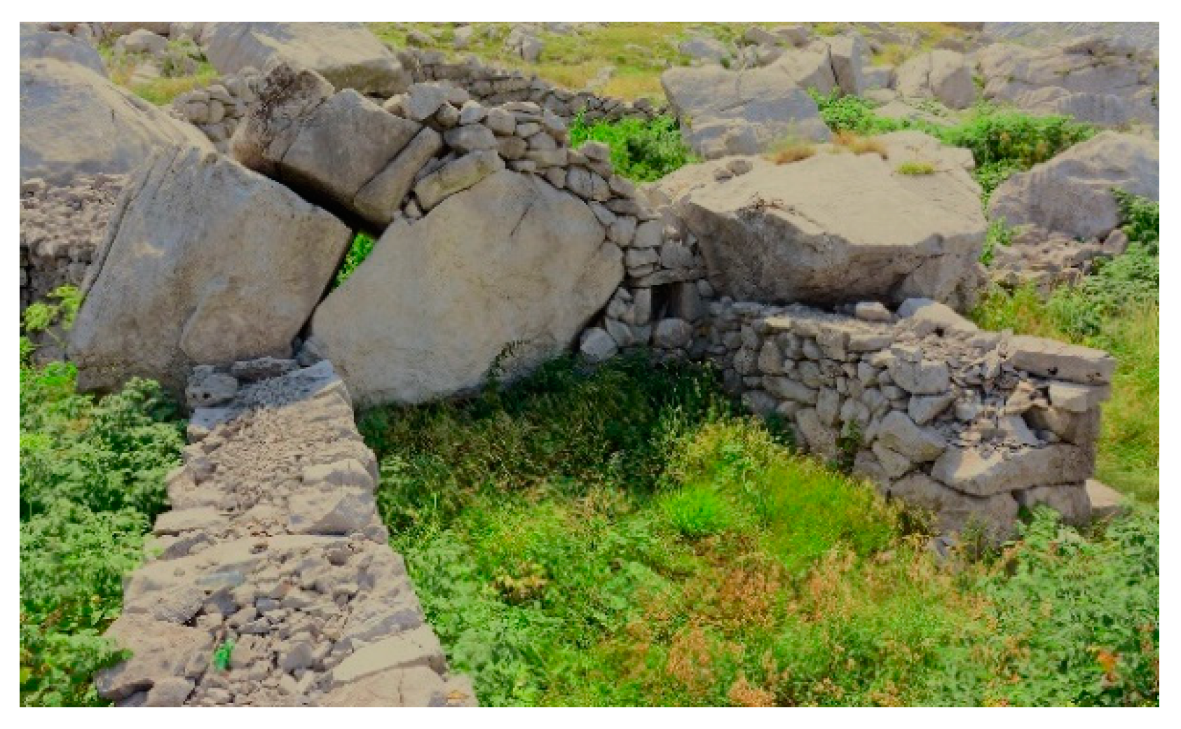
Gladas were built in a way that they were maximally adapted to the advantages of the terrain. Often, especially earlier, the existing stone formations, rocks and larger blocks of stone were used for foundations or parts of gladas’ walls. That way the work was reduced, materials were saved and gladas obtained additional stability (
Figure 14 and
Figure 15).
Gladas can be oriented with their longer side—the long wall/face vertically or parallel to the terrain line. Depending on the configuration of terrain and the position of the glada within the katun, we find both examples (
Figure 16 and
Figure 17). However, gladas vertically oriented to the terrain prevail, as it was the practice with houses in the villages [
5] (p. 80).
When gladas were built on slopped terrain, they were most commonly partially dug into the terrain with its rear part next to the slope, regardless of whether they were oriented parallel or vertically to it. It was practiced in order to get a flat base for a glada on slopped terrain, faster and easier construction, greater stability and durability, as well as thermal insulation. In the part that was dug into the ground, only one face of the stone wall was built, whereas the rest of it continued with two faces. The digging into the ground may have been partial, up to a certain height of the wall, but often the entire back wall was also dug into the ground (if it was flat). When the back wall of the glada was the classic gable wall (the stonework triangular ending), the lower section of the wall was dug into the ground, while the triangular section remained above.
3.1.3. The Size, Dimensions and Proportions of Gladas
The interior dimensions of the narrower side—sidewalls most commonly range from 3.00 to 3.50 m, maximally up to 4.30 m. The interior dimensions of the longer side—long walls or face walls vary from 4.20 m up to 7.80 m. The exterior dimensions of sidewalls of gladas are most commonly range from 4.80 to 6.00 m, and of the face from 7.20 m up to 9.70 m. Only around ten gladas in the entire region of the Kuči Mountain have a face longer than 10 m. It is assumed that such gladas were used in the institution of
supona, when two or more families shared the same glada during their stay in the katun. The proportions of gladas’ plans, the ratio of the narrower to the wider side of the rectangle, i.e., the sidewall to the long wall/face, range from 1.25 up to 2.0 m. It can be noticed that this proportion is often approximately around 1.6—which matches the golden section (
Figure 18).
The thickness of gladas’ walls is determined by the drystone wall technique applied, with two faces and the filling of smaller stone. The thicknesses of the wall most commonly range from 80 to 90/100 cm, although there are also walls up to 120 cm—and even to 130 cm—thick. In rare cases, there are thinner walls as well, up to 70 cm. Often, in the same glada, there is a difference in walls thickness. The sidewalls, especially in the upper parts, can be more delicately built and thinner than other walls.
Unlike the houses in villages, the walls of the cabins/gladas were relatively short and always shorter than the height of a man. The height of face walls of the preserved gladas most commonly ranges from 120 to 130 cm. However, there are also walls, which are around 150 cm high—and some even up to 170 cm.
In gladas with stonework sidewalls, for which it is possible that they represent an older type, the height of the sidewall, which also determines the height of the roof, ranged from 2.70 to 3.00 m. In gladas, which have leveled sidewalls, with a gable or a hipped roof, the height of the roof may were from 3.70 to 4.20 m. The height of the roof construction itself, from the top of the wall, in such cases was in the range from 2.00 to 2.70 m. When a glada had a stonework half-gable wall, its height most commonly ranged from 2.20 to 2.50 m.
3.1.4. Materials, Construction and Building Techniques
Along with climatic characteristics of the region and the way of life and economy of people, available building material to the greatest extent influenced the construction and the manner of construction of structures [
6] (p. 4). Stones and wood, quality sufficiently presented nearby, were used for the construction of gladas and the other structures and constructions at the Kuči Mountain.
All constructions of stone at the Kuči Mountain were originally made in the drystone wall technique [
9] (p. 81), from blocks of crushed or dressed stone arranged ‘in dry’, without any bonding agent—mortar, i.e., quicklime [
9] (p. 26, 63). Until the second half of the 18th century (until about 1760), houses in the Kuči villages were also made only of stone in the drystone wall technique, and lime mortar started being used only later [
9] (p. 80). The walls of gladas made in the drystone wall technique were built with two faces, the interior and the exterior, of larger blocks, between which the filling of rubbles was put. It was the simplest and most common stonework building technique, applied to gladas, dubirogs and subsidiary objects. Considering the geological composition of rocks in the area and the dominance of limestone, the walls of gladas were mostly built from irregular stone blocks of very hard, gray limestone (
Figure 19 and
Figure 20).
Gladas were built from stones, which were presented in the very place or in the immediate proximity. The blocks of stone were picked or taken out of the ground, and in such a shape or with a little bit of dressing, they were built into the wall [
9] (p. 80) (
Figure 21). In some zones, we come across the gladas made of more delicately dressed stones and with a better arrangement (
Figure 22). The type and quality of the stone which was found in the area of katuns affected building technique, arrangement types, as well as the look of the walls and their durability. In the zones with slate, gladas were built of more regular blocks of slate or sandstone in different colors.
There is a very small number of structures built in stone brought from remote mines and quarries, and they are all of a more recent date. The quality of stone located in the area of the katuns directly determined building techniques and the durability of structures built that way, and there are several katuns where, due to the lack of suitable stone, wood was used as the material for building all or individual walls of glada (
Figure 23). It is interesting to note that the practice of building such structures existed only in the katuns in the border regions of the mountain (locations Ćićerača, Velja and Mala Ćura), where the influence of building traditions of neighboring tribes should not be excluded either. In the areas where there were not enough available quality stone for building, such as Lještanski katun on Sumor, wooden, Bosnian pine (
Pinus heldreichii, locally named
munika) beams were used as a skeleton around which stone was arranged, providing it with stability and toughness.
3.1.5. The Roof Construction and Cover
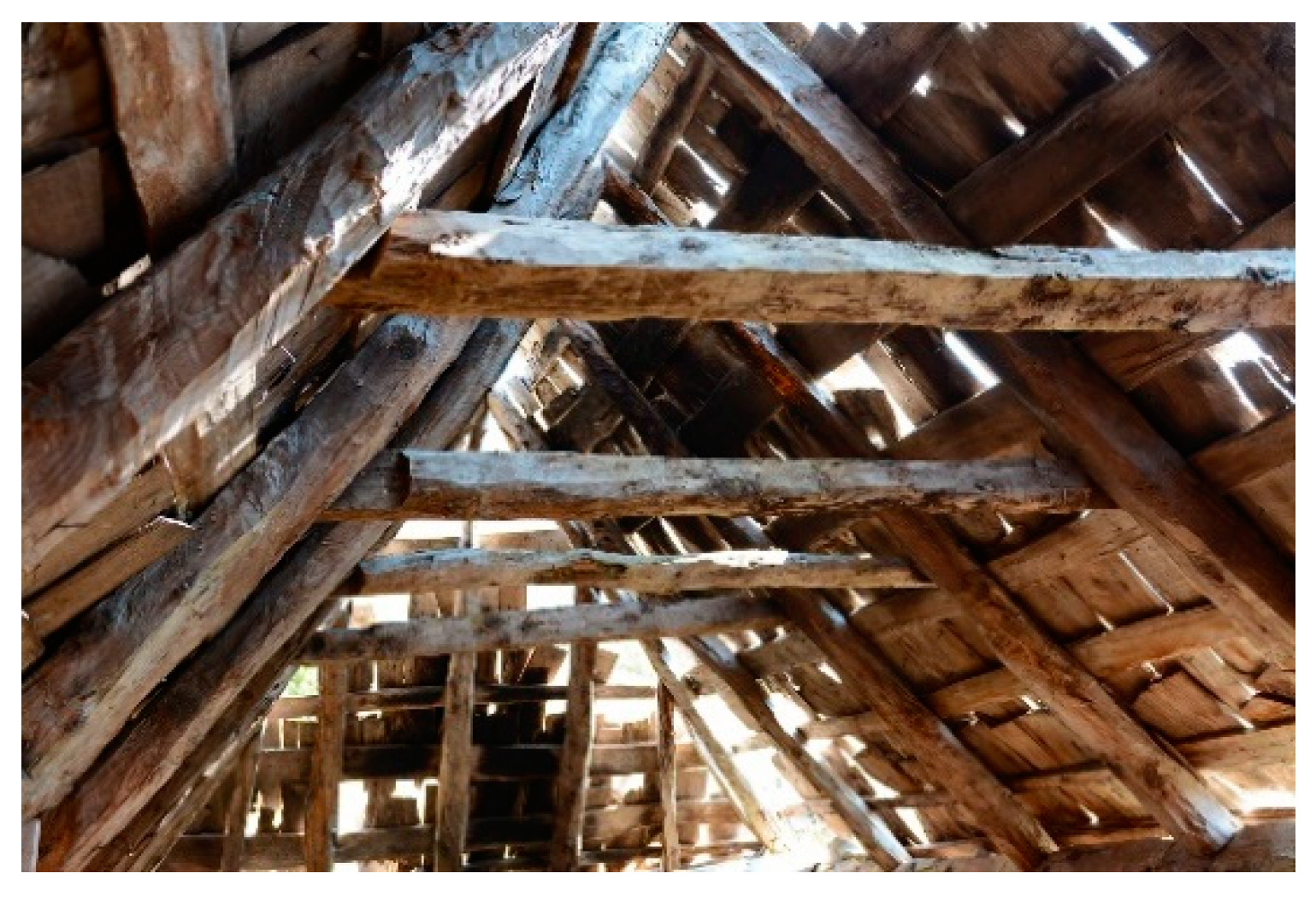
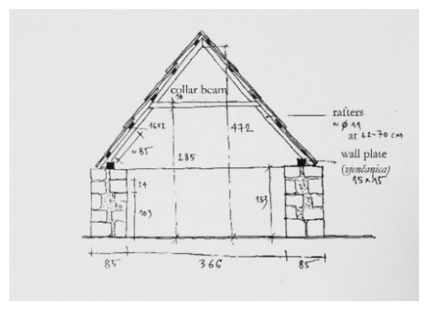
The roof construction of all types of gladas at the Kuči Mountain is wooden. Those are very simple constructions, possible to be made with the material and tools available at the mountain. Depending on the type of glada, the roofs can be simple gable roofs on gladas with stonework gable wall; gable roofs with the roof construction on the sidewalls; hipped roofs and, in some cases, three-pitched roofs. The simplest gable roofs are basic roofs with rafters (
Figure 24), which are called
nožice at Kuči, which lean onto the wall of the glada, sometimes directly—and sometimes over a horizontal beam—
vjenčanica (the wall plate) [
7] (p. 236).
The simplest wall plates can be made of round logs, with a circular diameter of 12 cm and more. In older katuns, we find wall plates of a triangular shape, especially when they were made of the Bosnian pine or fir. They are of greater dimensions, with sides from 15 up to 30 cm—and sometimes even more. In addition, wall plates of a rectangular or square cross-section, ranging from 12 up to 16 cm, occur. In the construction of roof of greater dimensions, between the rafters, collar beams are often set at 1/3 or 2/3 of the height of the roof. In some cases, double collar beams are set as well, on both sides of the rafter (
Figure 25,
Figure 26 and
Figure 27).
Most commonly, the wood of fir, beech and Bosnian pine was used for building. Due to its mechanical characteristics, the fir (
Abies alba) was most commonly used for roof building of gladas, either for the construction itself or for the board the roof which it was covered with. The Bosnian pine was used in the same way, but considerably more rarely. It is interesting to note that its extraordinary toughness and resilience often enabled the roof construction to outlive the very stone walls, in particular if these were built or the stone of a poorer quality [
28]. The beech (
Fagus moesiaca) was used, particularly more recently, for both the construction and the roof cover. In zones where quality timber was available and quality stone lacked, wood was used for building entire cabins, their walls, construction and roof. Wooden constructions on gladas, including their walls, were commonly made and built by katun people themselves through
moba (the voluntary common work of all) [
15] (p. 45).
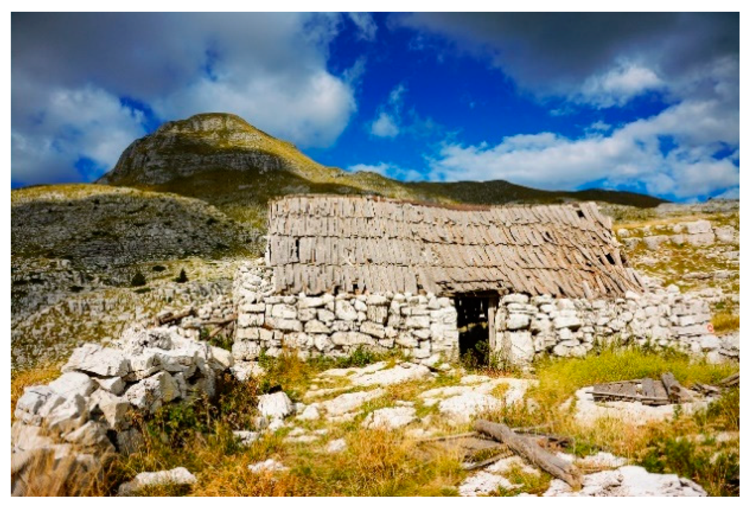
Roof covers of gladas at the Kuči Mountain changed over the time. The oldest types of gladas were originally covered with
pustina—the cloth of goat’s hair, then with straw, afterwards with wood, and lately they were covered with tin or other contemporary materials. Gladas with the cover made of
pustina have not been preserved, while the roof of straw, widespread at the eve of 20th century, survived on only several gladas at the Kuči Mountain nowadays [
7] (p. 26) (
Figure 28).
Until the sixties of 20th century, wooden boards in different variants were most frequently used for the roof cover. Earlier, particularly in higher katuns, gladas were covered with cut planks called
skudla [
9] (p. 26) (
Figure 29). The planks were cut from fir or pine in forests in the immediate proximity of a katun and on horses brought there. Based on the photographs and notes from the beginning of the 20th century, it can be concluded that the planks may have been around 1.2 to 1.8 m long [
9] (p. 60) and 20–30 cm wide. These boards were not originally fixed with nails, but at the end of the season, they were removed and piled inside the walls of the glada. In that way the roof construction was protected from exposure to the pressure of snow cover [
9] (p. 25, 36). Only later, with more modern tools for wood processing, a period of the permanent covering of roofs started.
Such roofs evolved into ones made of
skudla boards, mostly made of beech wood and of one ell in length (around 71 cm). Throughout the middle of 20th century, this was the most widespread type of traditional wooden roof cover of gladas with higher gable or hipped roofs. As gladas did not have chimneys, the smoke from the hearth escaped through openings and cracks in roof constructions [
15] (pp. 46–47). The smoke itself served as a sort of preservative for wooden roof constructions and the roof cover of straw or wood, preventing the development of microorganisms causing decay.
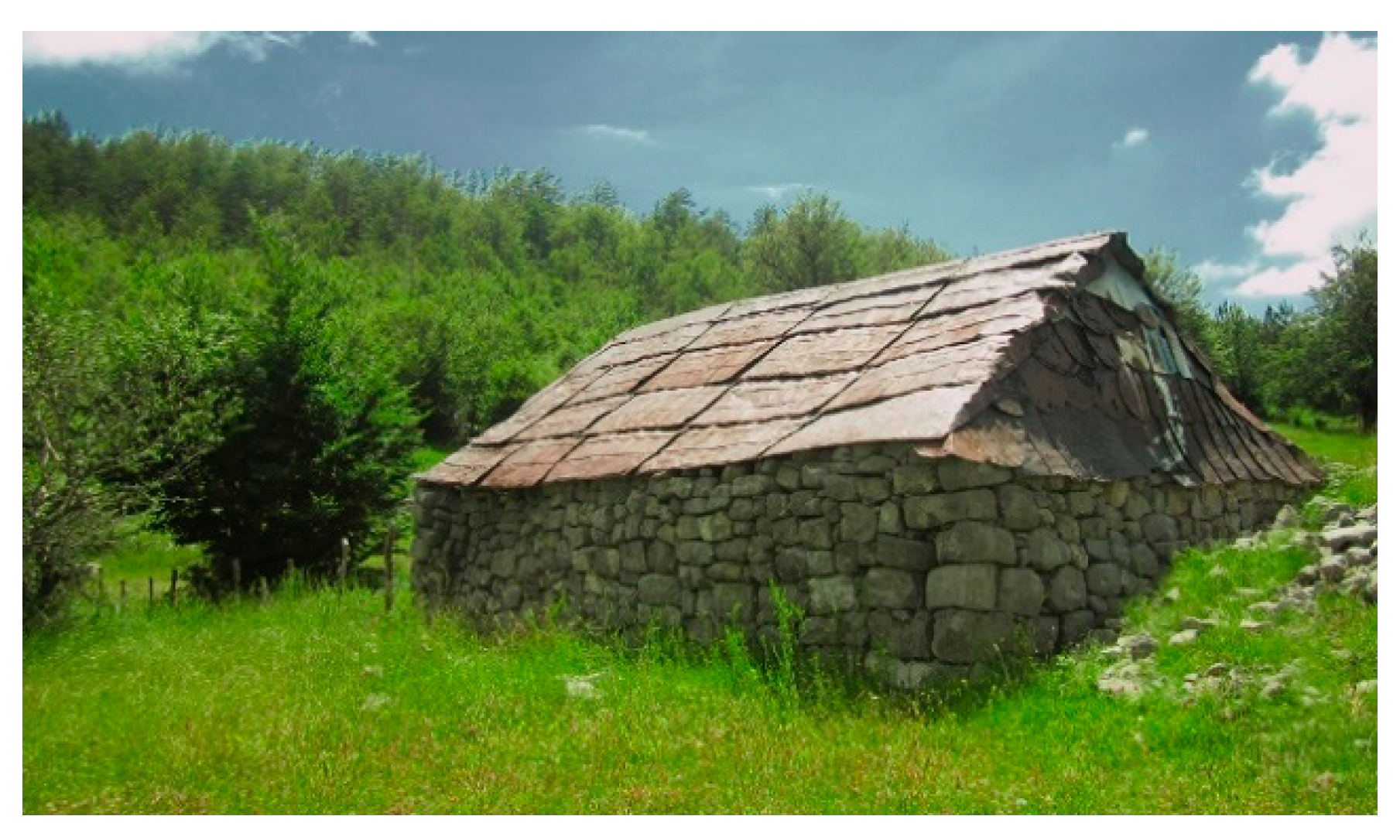
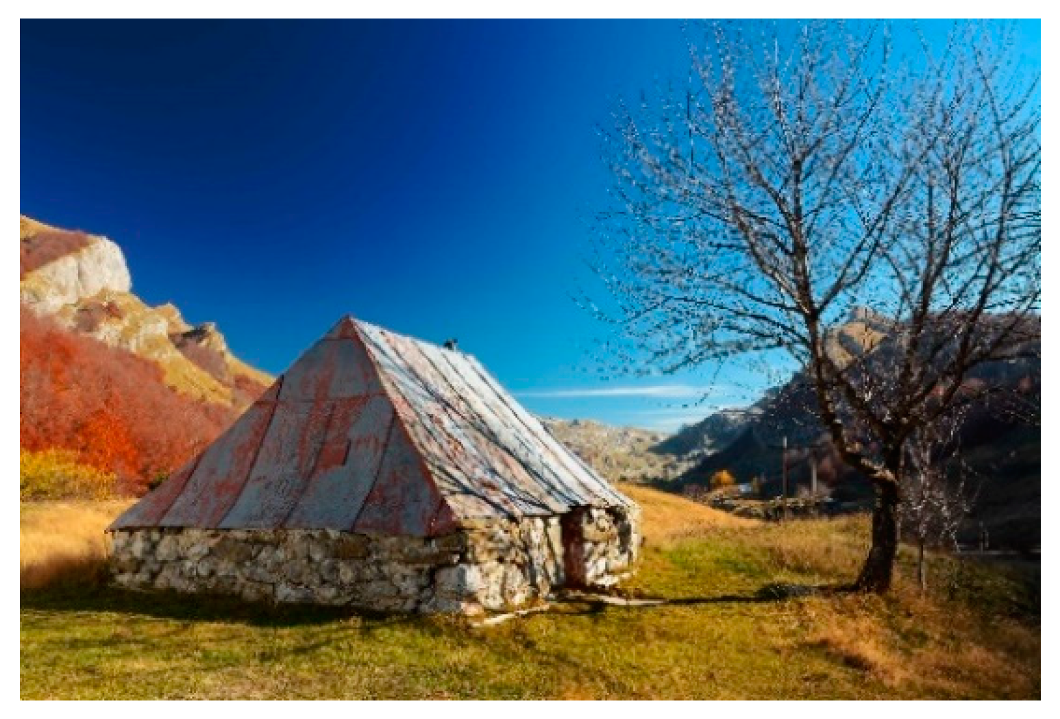
At the beginning of the 60 s of the 20th century, the thick tin, obtained by flatting metal barrels, became very popular as material for covering the roofs. Cheap, available in the region and durable, it has been in a mass used throughout, especially in katuns accessible by roads so the building material could have been brought in by lorries. Over time, tin totally pushed out wood as material for covering gladas’ roofs (
Figure 30 and
Figure 31). Today, except in older gladas, wooden roofs are presented only on weekend structures and in the cases when the owners, for esthetic reasons, want to imitate as much as possible the traditional look of the cabins.
Regular maintenance, repair of damaged parts of the drystone wall or roof constructions every spring were crucial for the preservation of gladas [
7] (p. 235). At the Kuči, tribal contract on katuns of 1904, stated “That no one is to touch building material from someone else’s pen or a plank from the cabin. Who do that without permission of the owner, such shall be at once delivered to the court of law for a trial in the sense of the law; he shall be treated harshly as a thief” [
9] (p. 24).
The use of new materials such as bricks and concrete blocks for the construction of walls or different kinds of covering materials for roofs is more than common nowadays, but such structures are rarely considered to be gladas. The local population connects this term to just one specific type of structure, which is deeply rooted in its tradition.
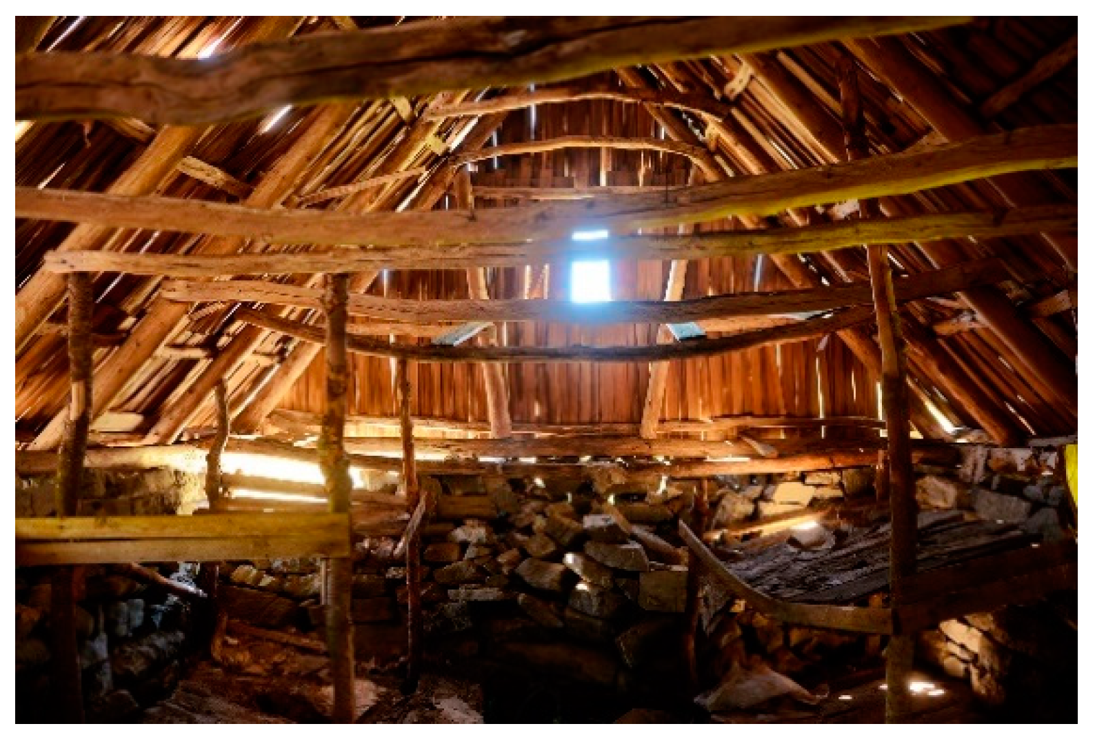
3.1.6. The Interior of Gladas, Their Elements and Subsidiary Objects
Gladas in katuns of the Kuči Mountain feature a simple interior organization, usually a one-unit space without partitions and with one door [
27] (p. 121). “In the middle of the glada, there is the hearth and, close to it, a bed space for sleeping made of stone and beams” [
7] (p. 236). In most cases, the door was located on the longer wall, most frequently at 1/3 of it. In that way the position of the door functionally divides the interior space of the glada in two parts. The zone around the hearth was mainly related to regular activities around preparation of dairy products: sitting benches, niches in the walls, shelves. The beds were located on the other side, but often raised off the ground, so that the space beneath them can be used as well.
The floor in the glada is of beaten earth. The hearth is located on the floor, on the same level as the floor and is ringed by stone blocks. It can be of a square or circular plan, with a diameter of about 70 cm. Table was most commonly located in the middle of the glada, longitudinally right next to hearth. In order to have a space on the floor free, the wooden shelves were attached to rafters of the roof construction [
7] (pp. 236–237) (
Figure 32).
In the sleeping part, probably it was originally slept on the floor or on the benches next to the wall. Wooden beds or galleries for sleeping appeared later. One type of these constructions is beds in the corners of a glada, set on small wooden pillars. In the examples of such beds which have been preserved, they are at a height of 80 and 120 cm off the floor, 1.3–2.1 m in width and about 2 m in length [
27] (pp. 735, 782). There are also examples of forming wooden platforms for sleeping between two long walls of a glada, when a wooden beam is stretched between two walls and boarding is set on it towards a sidewall. In preserved examples, such constructions were raised at around 95 or 130 cm above the floor. In more numerous families, this kind of construction often grew into a wooden attic (gallery), placed on the glada walls, where several more people could have slept.
In gladas, there are no windows, but sometimes, at the front of the gable or hipped roof, there was one minor opening near the top. There was no chimney, so the smoke escaped through the above-mentioned openings and cracks in the roof. With the introduction of the wood-burning stove instead of the hearth, in the interior of the glada, a metal drainpipe was also added, which usually led to the opening in the upper part of the sidewall. In gladas where the hearth originally was placed in the exact center, with table closer to the sidewall, stove and table would have exchanged their places. Such a solution contributed to a better warming, with minimal interventions on the entire construction of the structure.
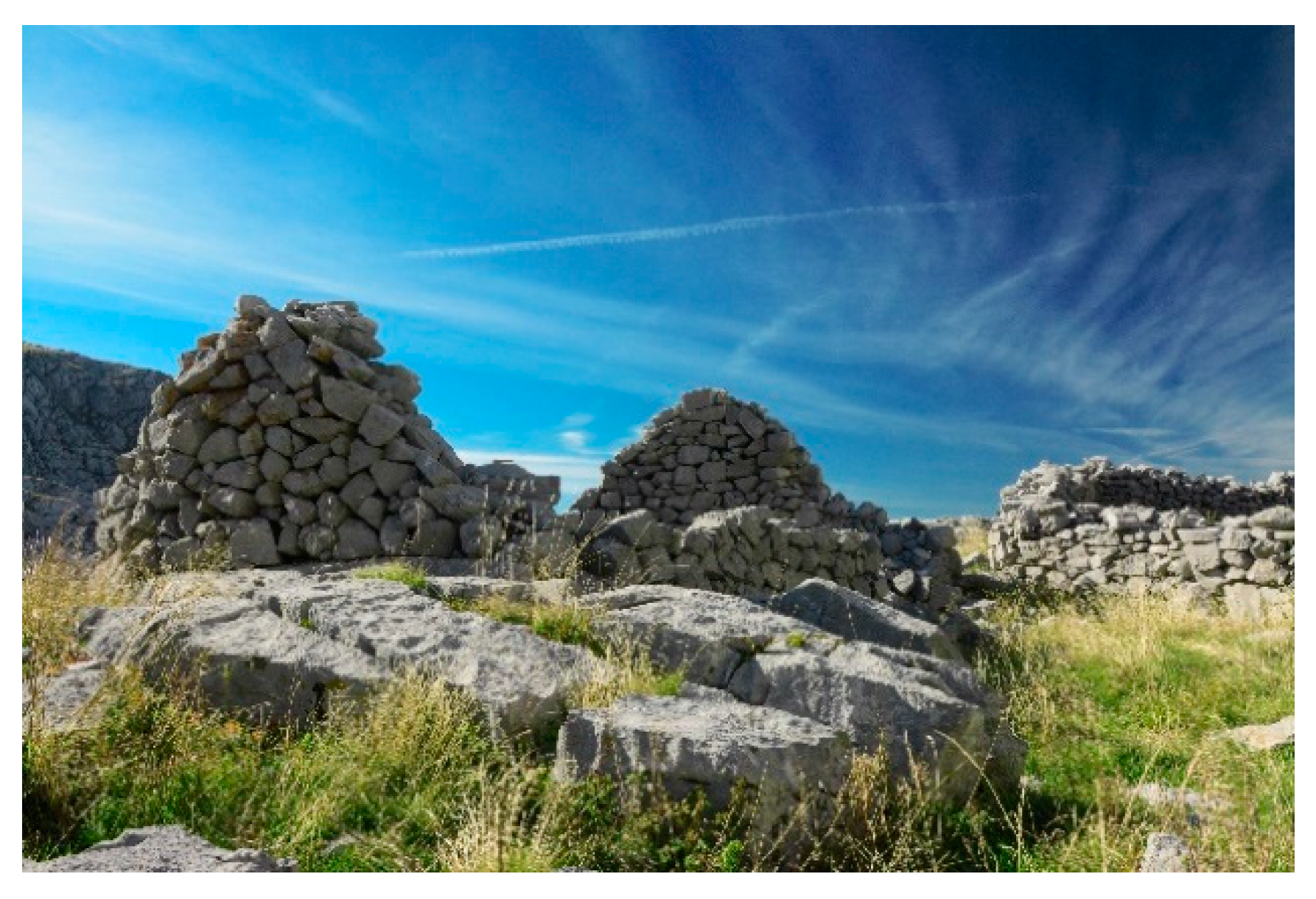
Apart from gladas, there are many other katuns’ subsidiary objects, which were of great importance for life and everyday livestock farming activities. They were made in the similar masonry manner as gladas, but smaller in dimensions and with less material, being mostly used for making and preserving dairy products.
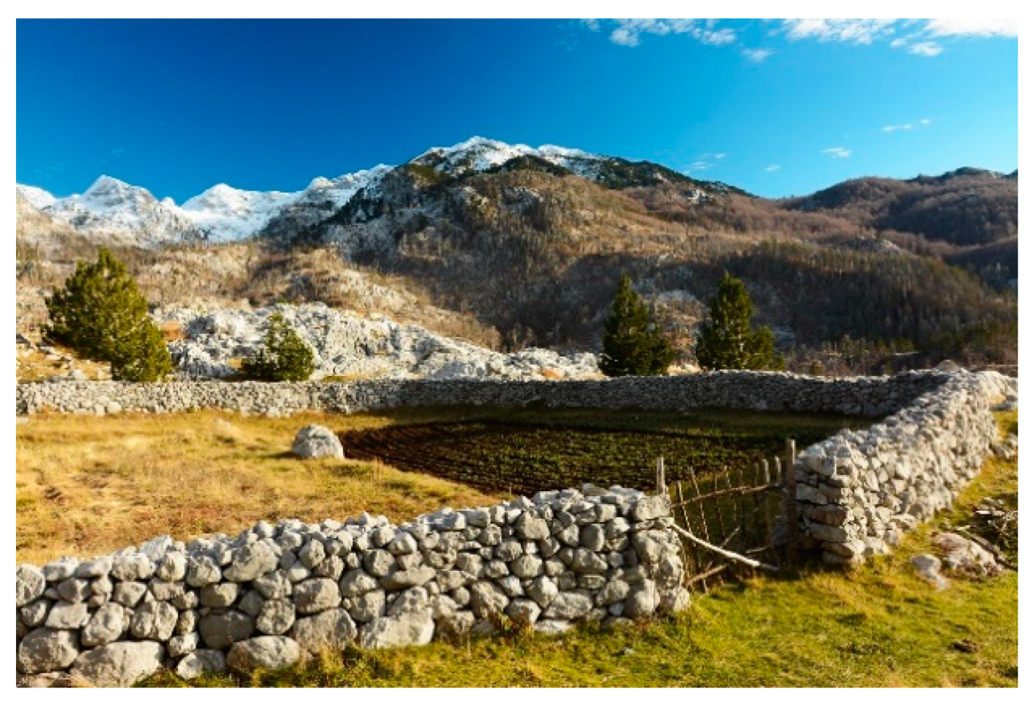
Torine—the sheep corrals are mainly located beside gladas, for facilitating work concerning livestock and protection from wolves. They were built predominantly in the drystone wall technique [
29] (
Figure 33). Although sporadically, in katuns of the Kuči Mountain, there were also pens weaved with switches, pens of nailed branches, pens of sticks and combined pens.
The sizes and shapes of corrals vary according to the configuration and morphology of the terrain, sizes of the flock and financial capacities of the household, and the largest ones are getting a new purpose today. Considering that there is the best manured soil in katuns, they provide favorable conditions for growing potatoes in the areas where livestock grazing—especially sheep grazing—was reduced or abandoned (
Figure 34).
4. Discussion
In the last ice age, the mountainous area of the southern Dinarides—including the Kuči Mountain—was exposed to the impact of glaciers. Their activity formed characteristic forms of glacial relief, including glacial lakes and glacial valleys with moraines. Villages and katuns in the mountainous zones “...are mainly located around stadial moraines and in the cirques which are sheltered from winds, as well as on cirque terraces...” [
4] (p. 243).
The mentioned natural forces that shaped and designed the forms and outlooks of katuns at the mountain, also provided the framework for organization of specific lifestyle within and around them. That lifestyle—lasting for generations and surviving numerous social and political changes intact until the second half of 20th century—created a complex heritage that decisively shaped the sense of population’s identity. It means that in such defined context, both individuals and community were functioning according to social rules established through adjusting to natural ones. In small and economically poor societies—as those in the Southern Balkans mostly were—this led to societal grouping thoroughly determined and defined by the landscape.
Starting there, the heritage stories spread out in different directions, creating different subcontexts and subcategories, and resulting in contemporary mountain heritage diversity. At the Kuči Mountain, that flow was shaped by the nature of different landscape characteristics and the community response to it. Every katun’s community had to adjust to them, largely adopting their impact as the part of local self-definition. Even though their villages looked similar, the differences among their katuns greatly influenced their self-recognition. The elements of tangible and intangible heritage from these areas almost always bear the marks of this sensibility.
Regardless of category or kind, the katun heritage is the widest context encompassing complete lifestyle circle, from legal documents, through solid objects and economic practices, to the realm of customs, beliefs and behaviors of the people living at the Montenegrin mountains. Although this research primarily dealt with its architectural and construction sphere, gladas’ roofs and corrals’ walls refer to a much wider heritage domain.
The tribal contract [
10] (pp. 343–345), which regulated a seasonal stay of inhabitants of the local community in the mountains, entailed, apart from rules on the use of pasturages, the right of felling trees, heating and other needs of the household, including making objects for the household and building katuns and dwelling cabins. “...At Kuči, the layout of katuns as complexes and buildings within them has also been dictated by the need for protection from enemies and other mountain nuisances such as beasts and not only by economic moments, which in normal circumstances should be of primary significance. Therefore, the Kuči katuns and cabins—gladas are more of a nucleated type....” [
13] (p. 130).
Traditional mountain cabins—gladas are the most important category of architectural heritage of the Kuči Mountain. Their appearance evolved with the development of available tools and with the improvement in the material and financial state of the population itself. The original type of dwelling was a mobile construction of wooden beams set in a circle and connected in one point by tying. It was originally covered with the cloth of goat’s hair, and then with beech branches, leaves or straw. This kind of structure was intended to last only one season. The first stonework structures, so-called dubirogs, were also of a circular form, made in the drystone wall technique and partially dug into the slope. The roof construction entirely resembled the original temporary structures, with the difference that the roof beams did not start from the ground, but from the wall of the structure [
15] (pp. 44–46). Although simpler for building, this type of structure was less suited to the needs of the interior organization of space, therefore it was superseded by stonework structures with a rectangular plan.
In the mid-19th century, the construction of squarish gladas with stone walls started, where, most commonly, the sidewalls were made in stonework up to the top. As building material, stone was both more available and it required fewer tools for processing, so the aim was to reduce the use of timber to the smallest possible extent. The tops of the sidewalls were connected with the ridge board, from the timber of the fir or the Bosnian pine, and less often of the beech and covered with cut boards. These boards were not originally fixed with nails, but they were removed and piled inside gladas’ walls at the end of the season. That way the roof construction was protected from exposure to the snow cover pressure, and later, with more available tools for wood processing, the period of permanent roof covering started, as well as the construction of structures with one stonework sidewall or without them. Where it was available, roofs were covered with straw for isolation [
15] (p. 46).
It is important to notice that even simplest and smallest improvements in common wealth led to significant leaps forward in specific spheres of katun’s life. For example, the use of metal nails became common practice in construction only at the beginning of 20th century. This enabled construction of more sophisticated and solid roofs, providing a significant increase in quality of life and work in katuns. Along with making the dwellers’ lives cozier, it consequently benefited to improving conditions for producing and preserving dairy products, as it was the main goals of the whole activity. In such objects, more comfortable for life and work and with higher hygienic level, it was easier to produce traditional cheese and other products in larger quantities and of better quality. This seemingly insignificant change, at the time taken for granted in many other parts of the Mediterranean, had an enormously positive influence to the whole system of mountain pastoral economy.
Techniques of the masonry construction of gladas range from the original drystone wall technique, over the technique of drystone wall filled with mortar after building, to the technique involving use of mortar as a bonding agent during the building itself. The drystone wall technique was the sole method of construction of structures until the beginning of the 20th century. Filling, originally with lime mortar, and later with cement mortar, was used only for consolidation and reconstruction of built structures in the drystone wall technique. The use of mortar, as a basic bonding agent, today is the most common form of construction, considering that roads enabling transport of the appropriate quantities of cement and sand, nowadays reach most katuns.
The katuns are now facing with three different trends—traditional use for summer grazing, transformation into recreational and leisure settlements and abandonment. The number of families who still bring up their cattle and sheep to the mountain pastures is rather small, but still visible and relevant. The second trend is mostly related to people who inherited the right to build the cottages in the katuns’ areas, but don’t have the intention to practice agriculture activities. There are different examples of how this trend influences the katun’s life and general landscape. Such practice preserved some connection between people and the mountain, but, more often than not, new constructions disturb the outlook of the traditional landscape with use of inappropriate materials, construction techniques and designs. We find the results of our research important for dealing with this category, since the presented data can provide the base for national stakeholders to determine the relevant legislation that could both promote the maintaining contact with mountain areas and protect the traditional landscape as the value per se.
The abandonment of katuns is the most visible trend, induced mostly by the changed economic constellation within the society. What also contributes to it is a general silence on the matter, where this topic is rarely covered in the media or draws1 public’s attention. Investigations of this kind cannot bring people back to the mountain pastures but can help in creating the atmosphere where the katuns’ lifestyle is treated as socially important, pushing the stakeholders to provide more favorable administrative and economic preconditions for continuing that activity.
The comprehensive social and economic changes in the Montenegrin population lifestyle, having emerged from rapid industrialization and depopulation of rural communities in the second half of 20th century, led to the drastic abandonment of katuns. That process not only affected the katuns themselves, but also triggered the scientific demotivation to research this topic. Taking their existence for granted, researchers from this part of Europe have missed the opportunity to tackle the topic in times when a greater number of katuns functioned, and when more data on abandoned ones could have been obtained via oral interviews with locals remembering their previous condition. Nowadays, facing with present danger of losing the whole concept of katun’s lifestyle, we assume as our scientific obligation to preserve and analyze still available data on the subject. As mentioned before, one of the first implications we expect that our research will have is acquiring a degree of legal protection for the transhumance, as well as raising the public and scientific awareness on the importance of the topic.
However, the main focus of this research was data gathering for the first complete inventory of katuns in one of the Dinaric mountains range regions. It may sound unbelievable nowadays, but this category has been almost totally neglected and put aside, so it was impossible to find any reliable quantitative information on both katuns and subsidiary objects. Prior to this research, one could find only some scattered data from the beginning of 20th century about katun’s life, without figures describing number, disposition, organization, contents and architectural and construction characteristics of katuns and adjacent housing and subsidiary objects. For the first time, we compiled a more complete inventory of katun’s material cultural heritage, with reliable and in-situ-checked data related to mentioned categories.
Altogether, the goals of our research were:
To bring the attention of different scholars (historians, ethnologists, archaeologists, anthropologists, architects, environmentalists, etc.) to this subject;
To draw public’s attention through acquiring specific and previously unknown data on the one of characteristic of katun areas;
Establish a role model and field work methodology, appropriate for further investigations in similar areas and
Motivate the local stakeholders to consider enlisting katuns and transhumance in the national list of protected intangible cultural heritage, as it was done in Greece, the Apennines and the Alps [
19].
We believe that the obtained results—especially since there were no other currently existing data on this topic regarding Montenegro—can be of great help to the researcher venturing into domain of seasonal mountain settlements in this part of Europe. The research outcomes contain data on different aspects of local architectural heritage, which are relevant to many other Montenegrin mountain areas, as well as the other Balkan regions where the transhumance existed. Precise determination of traditional building techniques and used material, as well as characteristics of thus constructed objects are already recognized by EU member countries as the base for legalization of building activities within protected mountain areas (example of
Velika planina, a traditional katun area in the Slovenian Alps) [
30]. We expect that data emerging after our research will help arranging similar status for the traditional katuns’ regions in Montenegro. Moreover, scholars and researchers from the fields of vernacular architecture, ethnology and social history will benefit from data obtained from this research.
5. Conclusions
Nowadays, katuns in Montenegro have lost their traditional economic importance. The contemporary lifestyles, needs, and habits of the population do not include agriculture and livestock-rearing and traditional practices as dominant activities. This leaves the whole infrastructure of rural settlements and katuns—established throughout centuries—in a difficult position where their abandonment and desertion become regular. Deep and thorough social-demographic changes in the Montenegrin society after the World War II rendered realms of existing life practices obsolete, including the seasonal transhumance with livestock to katuns in mountains. The impacts of this phenomenon on the sense of society identification as a whole notwithstanding, this caused a gradual abandonment of hundreds of katuns on the slopes of the Montenegrin mountains—along with tens of thousands traditional housing and subsidiary objects. Their number and contents testify to the way of life. They enabled survival to generations of people, who used to lean on them during their whole life. Overall, they present a valuable cultural and historical heritage that should be treated with due scientific interest, in the very least.
In general, today’s condition of the remaining traditional housing objects, even in the still ‘living’ katuns, is far from good. Dwellings, as their name itself implies, are places to dwell in. Without people, they find it hard to resist entropy and rapidly turn into ruins. The abandoned katuns at the end of the 70 s of the 20th century today resemble archaeological sites from antiquity. Without smoke, wooden roofs rapidly decay and decompose, opening the way for water, which enters the interior of the stone walls. Melting and freezing processes in turns in the period from October to May result in walls unavoidable cracking and collapsing. Better constructed structures, particularly those partially dug into the ground, can last somewhat longer, but there is a very small number of gladas, made in the drystone wall technique, the walls of which remained completely preserved 50 to 60 years after having been abandoned [
31] (pp. 14–15).
Besides katuns’ individual characteristics, role in economic concepts and value as cultural heritage’s treasure, they must be observed as the authentic category of the traditional landscape. Correlations and interactions among natural and artificial structures, people, domestic and wild animals, herbs and forests created a complex picture with clearly defined roles and places of the protagonists. The human interventions in the natural landscape here used to adjust to, rather than to confront mountain rules, where their understanding led to precipitating of generational wisdom enabling constitution and development of the katuns as a viable and resilient system. The relation to terrain geomorphology not only determined the size and shape of katuns, but also distinguished successfully from the failed katun stories. Hence the outlook of traditional katuns does not reflect only the needs, knowledge and may of their direct builders, but the long-time experience of what, where and how to construct in order to last and function. Keeping in mind poverty and the lack of everything, but the basic tools, the quality and the functionality could have been achieved only through maximal adjusting to natural conditions.
On the other hand, traditional relations to pastures, water and forests that have dominantly determined katun positioning, shows a clear intention not to intrude into these domains as much as possible. Most katuns are built at the borderlines of rocky terrain and pasturelands, in order to preserve as much of pastures for grazing. From a purely esthetic point of view, such tendencies allowed an easier blending of shapes of artificial structures with contours of terrain. Made of in situ available materials and in sizes corresponding to the surroundings, the katuns more often melt into surrounding landscape than stand out of it. Unfortunately, without stronger social intervention such as more precise legal determination of preferable, acceptable and unwanted praxis, it seems that not only traditional katuns, but also the traditional katun landscapes as we know them, may be a thing of the past.
While this research covered only one of the traditional katuns’ areas in Montenegro, the main postulates can be applied to all the rest. While particular construction methods, shapes of the objects and used materials slightly differ from each other, the context of their use—as well as their present and perspectives—look the same. Since the application of new technologies enables contemporary researchers to acquire, analyze and store the obtained data more easily, the importance of the knowledge on their various domains rises.
In this sense, currently obtained results enable making exemplificative maps, valuable for describing the territory, with selection of the most stimulating points of interest. The results of the geo-database in QGIS contains a corresponding location for each building, their relation with infrastructure, land cover, morphology, vegetation, etc. Eventually, this will provide a centralized source of all relevant data from different locations, in a unified environment and the visualization of data on maps. We expect that in time more layers will be added and all layers can be interconnected and integrated with non-geographic information such as: opening hours of museums and other tourist attractions; hotels and restaurants rates and costs; events calendar; historical data, intangible heritage, flora and fauna, as well as other information regarding local society and economy.
To summarize, this research was the first of this kind in Montenegro, and among the first in region to have the main topic focused on katuns. Its practical results and contributions are presented through obtained detailed data on existing seasonal settlements and belonging objects within the case study area. While this may seem modest, it should be kept in mind that similar data on this topic had not previously existed either in historical documents or in other sources or relevant scientific literature. The concentration of katuns in observed region proved to be denser and more numerous than expected. When the acquired information is applied to the other mountain areas in the region, it will significantly affect the common knowledge on transhumance, its quantitative framework and architectural and construction heritage it had created. Combined with visible landscape changes caused through blending of creative human energies and the natural characteristics of the environment, such data become a part of not only description of the anthropogenic activity in the mountains, but also the measure of its correlation with them. The number of determined katuns—together with number of belonging housing objects—testifies that only a negligible percentage of the population of the case study area did not participate in this social and economic context, which also means that the situation can hardly differ in other Montenegrin mountain areas. This could mean that the katun heritage presents one of the most important heritage domains in the Montenegrin history, which should attract more of public and scientific attention.
This immense, but neglected category of cultural heritage of the Adriatic region can still provide an unexpectedly fruitful ground for future researchers [
32].


