Assessing How Land-Cover Change Associated with Urbanisation Affects Ecological Sustainability in the Greater Accra Metropolitan Area, Ghana


Abstract
1. Introduction
2. Materials and Methods
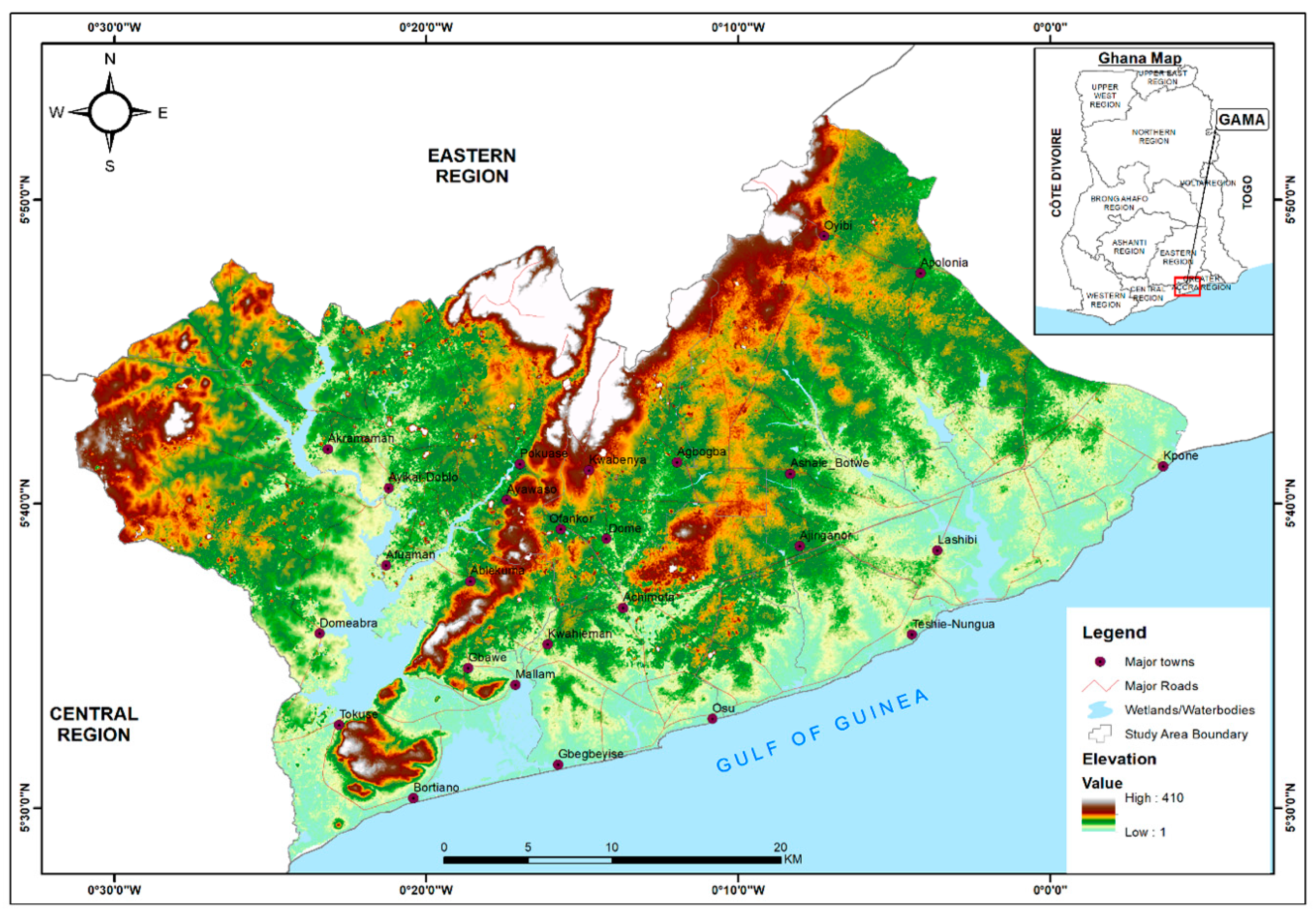
2.1. Study Area
2.2. Image Acquisition and Preproocessing
2.3. Image Segmentation and Classification
2.4. Land-Cover Change Modelling and Prediction
2.5. Land-Cover Change Detection Analysis
2.6. Land-Cover Accounting
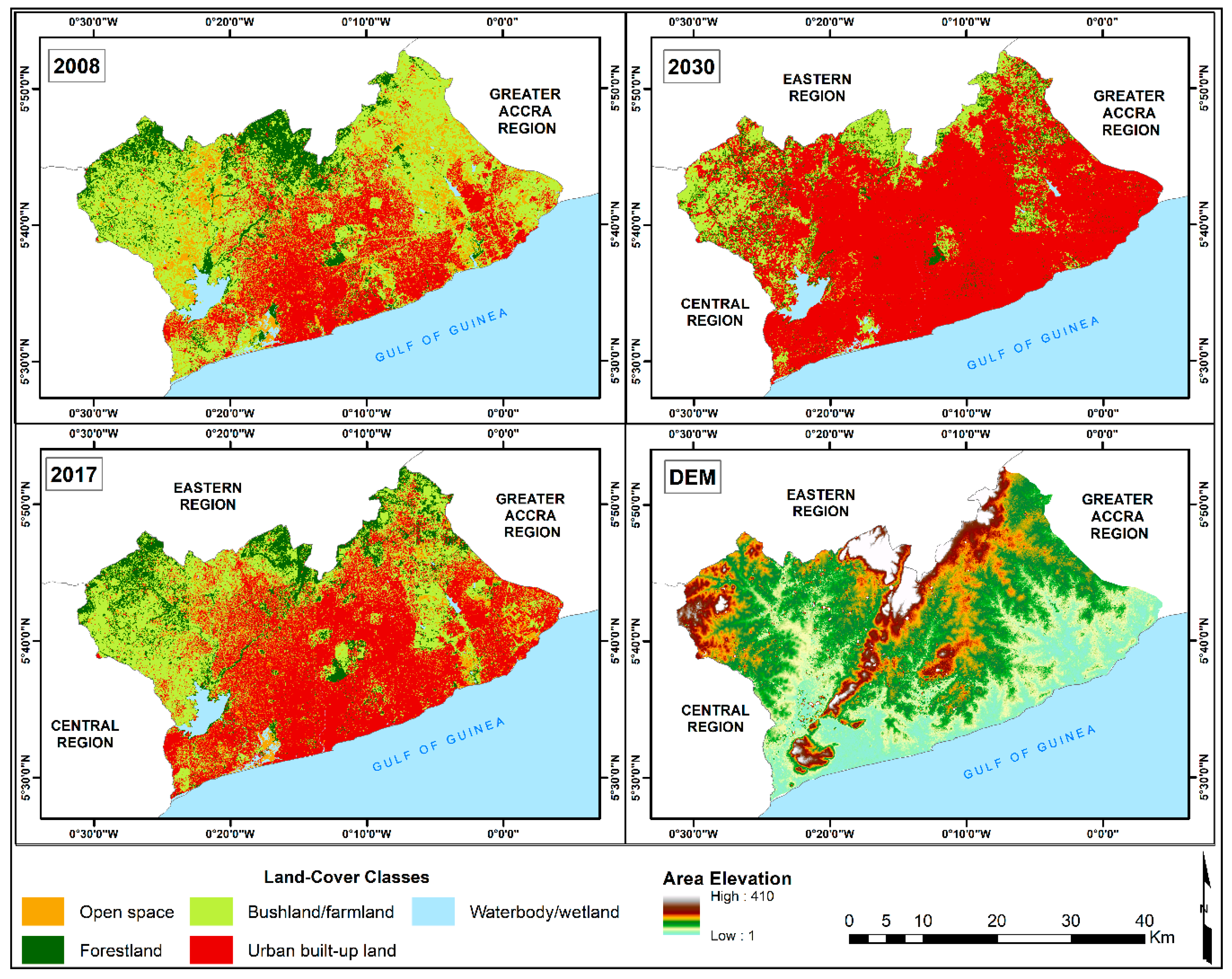
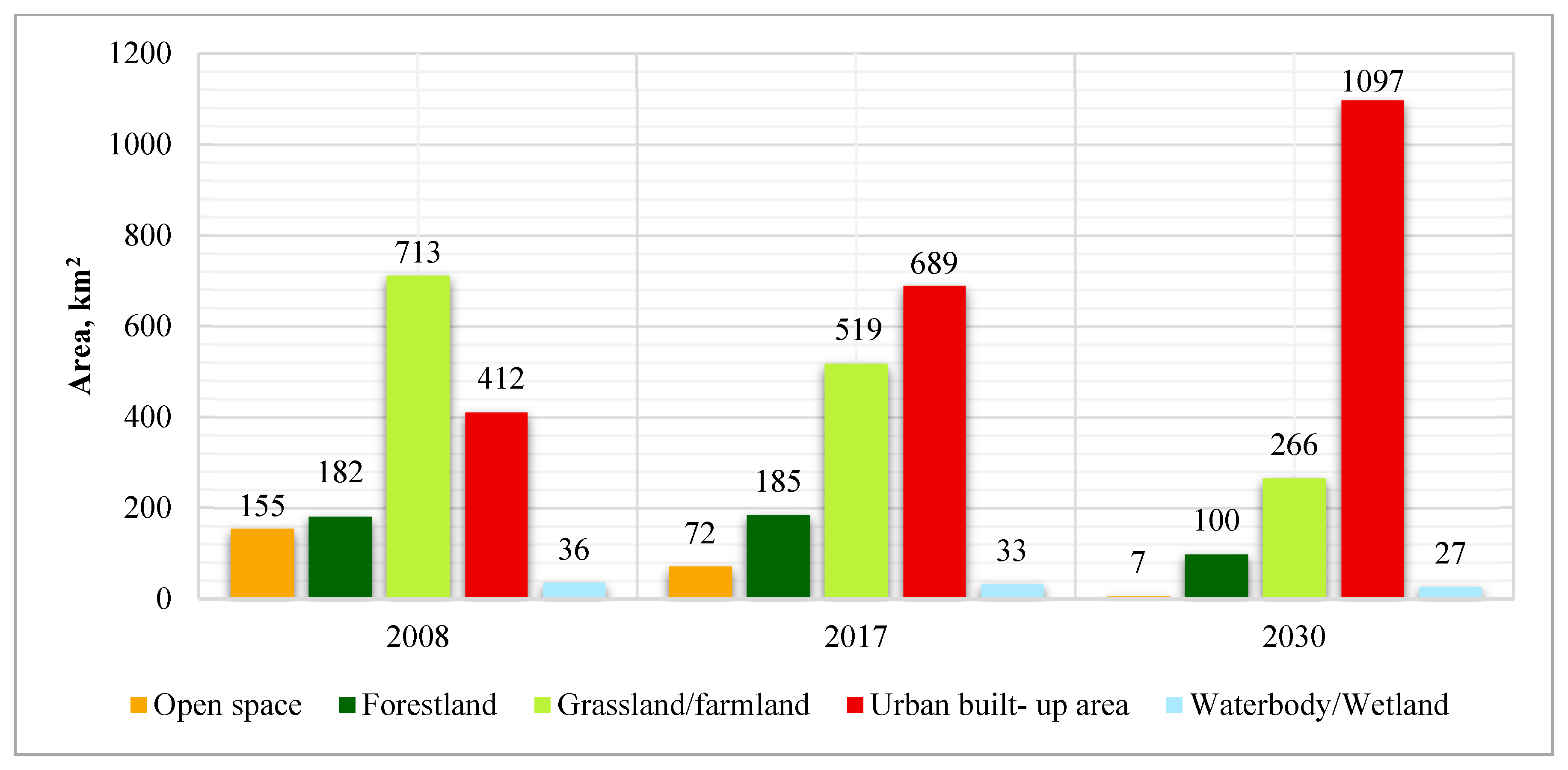
3. Results
4. Discussion
4.1. Dynamics of Land-Cover Change
4.2. Implications of Changing Patterns of Land Cover for Ecological Sustainability
5. Conclusions
Author Contributions
Funding
Acknowledgments
Conflicts of Interest
References
- Foley, J.A.; Defries, R.; Asner, G.P.; Barford, C.; Bonan, G.; Carpenter, S.R.; Chapin, F.S.; Coe, M.T.; Daily, G.C.; Gibbs, H.K.; et al. Global Consequences of Land Use. Science 2005, 309, 570–574. [Google Scholar] [CrossRef]
- Guerra, C.A.; Rosa, I.M.D.; Pereira, H.M. Change versus stability: Are protected areas particularly pressured by global land cover change? Landsc. Ecol. 2019, 34, 2779–2790. [Google Scholar] [CrossRef]
- Lambin , E.F.; Meyfroidt, P. Land use transitions: Socio-ecological feedback versus socio-economic change. Land Use Policy 2010, 27, 108–118. [Google Scholar] [CrossRef]
- Costanza, R.; De Groot, R.; Sutton, P.; Van der Ploeg, S.; Anderson, S.J.; Kubiszewski, I.; Farber, S.; Turner, R.K. Changes in the global value of ecosystem services. Glob. Environ. Chang. 2014, 26, 152–158. [Google Scholar] [CrossRef]
- Seto, K.C.; Golden, J.S.; Alberti, M.; Turner, B.L. Sustainability in an Urbanizing Planet. Proc. Natl. Acad. Sci. USA 2017, 114, 8935–8938. [Google Scholar] [CrossRef]
- Sharma, R.; Rimal, B.; Baral, H.; Nehren, U.; Paudyal, K.; Sharma, S.; Rijal, S.; Ranpal, S.; Acharya, R.P.; Alenazy, A.A.; et al. Impact of Land Cover Change on Ecosystem Services in a Tropical Forested Landscape. Resources 2019, 8, 18. [Google Scholar] [CrossRef]
- Jingan, S.; Jiupai, N.; Chaofu, W.; Deti, X. Land use change and its corresponding ecological responses: A review. J. Geogr. Sci. 2005, 15, 305. [Google Scholar] [CrossRef]
- Elmqvist, T.; Fragkias, M.; Goodness, J.; Güneralp, B.; Marcotullio, P.J.; McDonald, R.I.; Parnell, S.; Schewenius, M.; Sendstad, M.; Seto, K.C.; et al. (Eds.) Urbanisation, Biodiversity and Ecosystem Services: Challenges and Opportunities; Springer: Dordrecht, The Netherlands, 2013. [Google Scholar]
- Lambin, E.F.; Geist, H.; Rindfuss, R. Introduction: Local Processes with Global Impacts. In Land-Use and Land-Cover Change: Local Processes and Global Impacts; Lambin, E.F., Geist, H.J., Eds.; Springer: Berlin/Heidelberg, Germany, 2006. [Google Scholar]
- Opdam, P.; Luque, S.; Nassauer, J.; Verburg, P.H.; Wu, J. How can landscape ecology contribute to sustainability science? Landsc. Ecol. 2018, 33, 1–7. [Google Scholar] [CrossRef]
- Chowdhury, R.R.; Turner, B.L. The parallel trajectories and increasing integration of landscape ecology and land system science. J. Land Use Sci. 2019, 2, 1–20. [Google Scholar] [CrossRef]
- Seto, K.C.; Reenberg, A.; Boone, C.G.; Fragkias, M.; Haase, D.; Langanke, T.; Marcotullio, P.; Munroe, D.K.; Olah, B.; Simon, D. Urban land teleconnections and sustainability. Proc. Natl. Acad. Sci. USA 2012, 109, 7687–7692. [Google Scholar] [CrossRef]
- Haines-Young, R. Environmental Accounts for Land Cover: Their Contribution to ‘State of the Environment’ Reporting. Trans. Inst. Br. Geogr. 1999, 24, 441–456. [Google Scholar] [CrossRef]
- Loures, L.C. Introductory Chapter: Land-Use Planning and Land-Use Change as Catalysts of Sustainable Development. In Land Use: Assessing the Past, Envisioning the Future; Loures, L.C., Ed.; IntechOpen: London, UK, 2019. [Google Scholar]
- Meyfroidt, P. Environmental cognitions, land change, and social–ecological feedbacks: An overview. J. Land Use Sci. 2013, 8, 341–367. [Google Scholar] [CrossRef]
- Akber, M.A.; Khan, M.W.R.; Islam, M.A.; Rahman, M.M.; Rahman, M.R. Impact of land use change on ecosystem services of southwest coastal Bangladesh. J. Land Use Sci. 2018, 13, 238–250. [Google Scholar] [CrossRef]
- Wang, C.; Zhao, H. Analysis of remote sensing time-series data to foster ecosystem sustainability: Use of temporal information entropy. Int. J. Remote Sens. 2018, 40, 2880–2894. [Google Scholar] [CrossRef]
- Wu, J. Landscape sustainability science: Ecosystem services and human well-being in changing landscapes. Landsc. Ecol. 2013, 28, 999–1023. [Google Scholar] [CrossRef]
- Zhan, J. (Ed.) Impacts of Land-Use Change on Ecosystem Services; Springer: Berlin/Heidelberg, Germany, 2015. [Google Scholar]
- Akubia, J.E.K.; Bruns, A. Unravelling the Frontiers of Urban Growth: Spatio-Temporal Dynamics of Land-Use Change and Urban Expansion in Greater Accra Metropolitan Area, Ghana. Land 2019, 8, 131. [Google Scholar] [CrossRef]
- Korah, P.I.; Matthews, T.; Tomerini, D. Characterising spatial and temporal patterns of urban evolution in Sub-Saharan Africa: The case of Accra, Ghana. Land Use Policy 2019, 87, 104049. [Google Scholar] [CrossRef]
- Mahendra, A.; Seto, K.C. Upward and Outward Growth: Managing Urban Expansion for More Equitable Cities in the Global South, Working Paper; World Resources Institute: Washington, DC, USA, 2019; Available online: www.citiesforall.org (accessed on 9 September 2019).
- Hossain, M.S.; Pogue, S.J.; Trenchard, L.; Van Oudenhoven, A.P.; Washbourne, C.L.; Muiruri, E.W.; Tomczyk, A.M.; García-Llorente, M.; Hale, R.; Hevia, V.; et al. Identifying future research directions for biodiversity, ecosystem services and sustainability: Perspectives from early-career researchers. Int. J. Sustain. Dev. World Ecol. 2017, 25, 249–261. [Google Scholar] [CrossRef]
- Song, W.; Deng, X. Land-use/land-cover change and ecosystem service provision in China. Sci. Total Environ. 2017, 576, 705–719. [Google Scholar] [CrossRef]
- European Environmental Agency. Land Account for Europe 1990-2000: Towards Integrated Land and Ecosystem Accounting; European Environment Agency: Copenhagen, Denmark, 2006. [Google Scholar]
- Ghana Statistical Service. Urbanization in Ghana: 2010 Population and Housing Census Report, Ghana Statistical Service, Accra-Ghana. 2014. Available online: http://www.statsghana.gov.gh/docfiles/2010phc/Mono/Urbanisation%20in%20Ghana.pdf (accessed on 9 April 2018).
- GIBB. Greater Accra Regional Spatial Development Framework; Regional Spatial Development Framework Strategies and Policies Report; Volume 2, GIBB: Accra, Ghana, 2017. Available online: www.luspa.gov.gh/files/GARSDF%20Vol%202.pdf (accessed on 10 September 2019).
- EPA. Ghana State of the Environment 2016 Report; Environmental Protection Agency, Ministry of Environment, Science, Technology and Innovation: Accra, Ghana, 2017. [Google Scholar]
- Attua, E.M. Understanding land-use and land-cover change impacts on tropical ecosystems. In Social sciences series, University of Ghana, Selected readings in geography: Essays in commemoration of the 65th anniversary of the University of Ghana; Owusu, G., Agyei-Mensah, S., Yankson, P.W.K., Attua, E.M., Eds.; Woeli Publishing Services: Accra New Town, Ghana, 2013; pp. 265–280. [Google Scholar]
- Addae, B.; Oppelt, N. Land-Use/Land-Cover Change Analysis and Urban Growth Modelling in the Greater Accra Metropolitan Area (GAMA), Ghana. Urban Sci. 2019, 3, 26. [Google Scholar] [CrossRef]
- Ashiagbor, G.; Amoako, C.; Asabere, S.B.; Quaye-Ballard, J.A. Landscape Transformations in Rapidly Developing Peri-urban Areas of Accra, Ghana: Results of 30 years. Open Geosci. 2019, 11, 172–182. [Google Scholar] [CrossRef]
- Toure, S.I.; Stow, D.A.; Clarke, K.; Weeks, J. Patterns of land cover and land use change within the two major metropolitan areas of Ghana. Geocarto Int. 2018, 35, 209–223. [Google Scholar] [CrossRef]
- Ivanov, E.; Eigenraam, M. Land Accounts and Ecosystem Extent: Supporting document to the Advancing the SEEA Experimental Ecosystem Accounting Project; United Nations: Copenhagen, Denmark, 2015. [Google Scholar]
- Bruns, A. WaterPower—The Collision of Mega-Trends in a West African Coastal City. no. 1. 2014, pp. 24–27. Available online: https://www.fona.de/en/measures/funding-measures/junior-research-groups-global-change-4-1/waterpower.php (accessed on 12 May 2020).
- Ghana Statistical Service. Population Projections Summary 2010–2016: Data Production Unit, GSS. 2016. Available online: http://www2.statsghana.gov.gh/docfiles/2010phc/Projected%20population%20by%20sex%202010%20%202016.pdf (accessed on 4 February 2020).
- Li, X.; Feng, R.; Guan, X.; Shen, H.; Zhang, L. Remote Sensing Image Mosaicking: Achievements and Challenges. IEEE Geosci. Remote Sens. Mag. 2019, 7, 8–22. [Google Scholar] [CrossRef]
- Hong, G.; Zhang, Y. (Eds.) The Image Registration Technique for High Resolution Remote Sensing Image in Hilly Area. In Proceedings of the IEEE/ISPRS 3rd Internationational Symposium Remote Sensing and Data Fusion over Urban Areas, Tempe, AZ, USA, 14–16 March 2005. [Google Scholar]
- Bhatta, B. Urban Growth Analysis and Remote Sensing: A Case Study of Kolkata, India 1980–2010; Springer: Dordrecht, The Netherlands; Heidelberg, Germany; New York, NY, USA, 2012. [Google Scholar]
- Song, C.; Woodcock, C.E.; Seto, K.C.; Lenney, M.P.; Macomber, S.A. Classification and change detection using Landsat TM data: When and how to correct atmospheric effects? Remote Sens. Environ. 2001, 75, 230–244. [Google Scholar] [CrossRef]
- Solano-Correa, Y.; Bovolo, F.; Bruzzone, L. An Approach for Unsupervised Change Detection in Multitemporal VHR Images Acquired by Different Multispectral Sensors. Remote Sens. 2018, 10, 533. [Google Scholar] [CrossRef]
- Liu, J.; Li, H.T.; Gu, H.Y. A color balancing method for wide range Remote Sensing imagery based on Regionalisation. Int. Arch. Photogramm. Remote Sens. Spat. Inf. Sci. 2015, 7, W4. [Google Scholar] [CrossRef]
- Xiao, P.; Feng, X.; An, R.; Zhao, S. Segmentation of Multispectral High-resolution Satellite Imagery using Log Gabor Filters. Int. J. Remote Sens. 2010, 31, 1427–1439. [Google Scholar] [CrossRef]
- Eastman, J.R. TerrSet Geospatial Monitoring and Modelling System: Tutorial, Clark Labs. Clark University. 2016. Available online: https://clarklabs.org/wp-content/uploads/2016/10/TerrSet-Tutorial.pdf (accessed on 20 March 2020).
- Mansour, S.; Al-Belushi, M.; Al-Awadhi, T. Monitoring land use and land cover changes in the mountainous cities of Oman using GIS and CA-Markov modelling techniques. Land Use Policy 2020, 91, 104414. [Google Scholar] [CrossRef]
- Maes, J.; Teller, A.; Erhard, M.; Liquete, C.; Braat, L.; Berry, P.; Egoh, B.; Puydarrieux, P.; Fiorina, C.; Santos, F.; et al. An Analytical Framework for Ecosystem Assessments under Action 5 of the EU Biodiversity Strategy to 2020; Publications office of the European Union: Luxembourg, 2013; Available online: http://ec.europa.eu/ (accessed on 22 May 2019).
- Schindler, S. Towards a Paradigm of Southern urbanism. City 2017, 21, 47–64. [Google Scholar] [CrossRef]
- Agyapong, E.B.; Ashiagbor, G.; Nsor, C.A.; van Leeuwen, L.M. Urban land transformations and its implication on tree abundance distribution and richness in Kumasi, Ghana. J. Urban Ecol. 2018, 4, 297. [Google Scholar] [CrossRef]
- Alberti, M. Maintaining ecological integrity and sustaining ecosystem function in urban areas. Curr. Opin. Environ. Sustain. 2010, 2, 178–184. [Google Scholar] [CrossRef]
- Tetteh, K. The New Middle Class and Urban Transformation in Africa: A Case Study of Accra, Ghana, Master of Science in Planning, University of British Columbia Library, University of British Columbia, Vancouver. 2016. Available online: http://hdl.handle.net/2429/57950 (accessed on 17 June 2016).
- Swilling, M.; Annecke, E. Just Transitions: Explorations of Sustainability in an Unfair World; University of Cape Town Press: Cape Town, South Africa, 2012. [Google Scholar]
- Dale, V.H.; Kline, K.L.; Parish, E.S.; Eichler, S.E. Engaging stakeholders to assess landscape sustainability. Landsc. Ecol. 2019, 34, 1199–1218. [Google Scholar] [CrossRef]
- Pearson, D.M.; McAlpine, C.A. Landscape ecology: An integrated science for sustainability in a changing world. Landsc. Ecol. 2010, 25, 1151–1154. [Google Scholar] [CrossRef]
- Chaffin, B.C.; Gosnell, H.; Cosens, B.A. A decade of adaptive governance scholarship: Synthesis and future directions. Ecol. Soc. 2014, 19. [Google Scholar] [CrossRef]


| Year | Image ID | Sensor | Acquisition Date |
|---|---|---|---|
| 2008 * | P001 | Worldview-2 | 12/January/2008 |
| P002 | Worldview-2 | 12/January/2009 | |
| P003 | Quickbird | 15/December/2008 | |
| P004 | Quickbird | 09/March/2009 | |
| P005 | Quickbird | 15January/2008 | |
| P006 | Quickbird | 31/January/2008 | |
| P007 | Quickbird | 18/February/2008 | |
| P008 | Quickbird | 26/January/2008 | |
| 2017 * | P001 | Worldview-2 | 23/March/2017 |
| P002 | Worldview-2 | 23/March/2017 | |
| P003 | Worldview-2 | 01/January/2017 | |
| P004 | Worldview-2 | 17/January/2017 | |
| P005 | Worldview-2 | 17/January/2017 | |
| P006 | Worldview-2 | 17/January/2017 | |
| P007 | Worldview-2 | 17/January/2017 |
| Open Space | Forest Land | Grassland /Farmland | Urban Built-up Area | Water Body /Wetland | Total | |
|---|---|---|---|---|---|---|
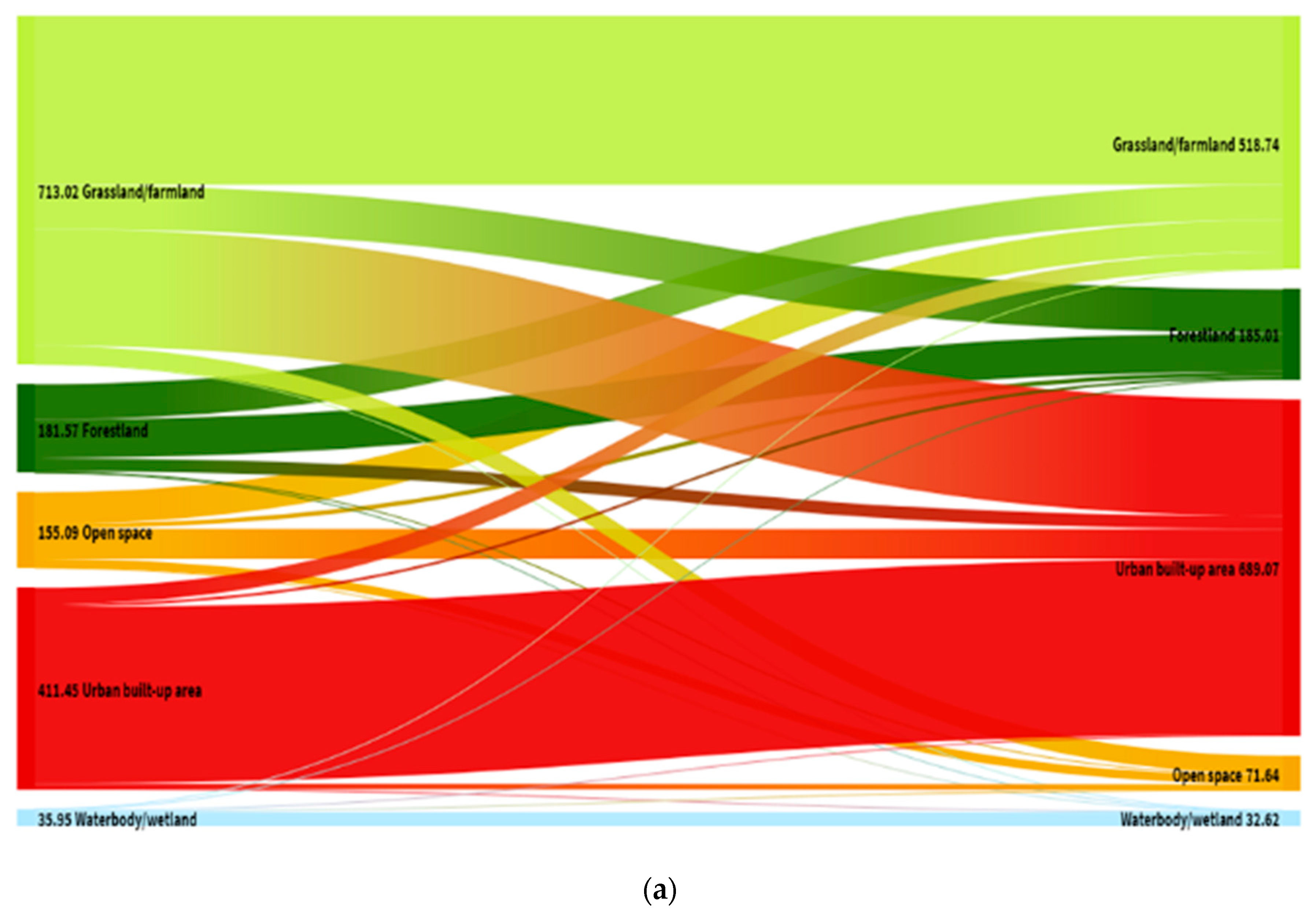
| Land-cover, 2008 (km2) | 155.1 | 181.56 | 713.02 | 411.45 | 35.94 | 1497.07 |
| Consumption of initial land-cover (km2) | 136.83 | 102.69 | 367.75 | 51.04 | 6.95 | 665.26 |
| Formation of new land-cover (km2) | 53.38 | 106.13 | 173.47 | 328.66 | 3.62 | 665.26 |
| Net Formation of land-cover (formation − consumption) (km2) | −83.45 | 3.44 | −194.28 | 277.62 | −3.33 | 0.00 |
| Net formation as % of initial year | −53.80 | 1.89 | −27.25 | 67.47 | −9.27 | −20.95 |
| Total turnover of land-cover (consumption + formation) (km2) | 190.21 | 208.82 | 541.22 | 379.7 | 10.57 | 1330.52 |
| Total turnover as % of initial year | 122.64 | 115.01 | 75.91 | 92.28 | 29.41 | 435.25 |
| No land-cover change (km2) | 18.27 | 78.87 | 345.27 | 360.41 | 28.99 | 831.81 |
| No. of LCC as % of initial year | 11.78 | 43.44 | 48.42 | 87.60 | 80.66 | 271.90 |
| Land-cover, 2017 (km2) | 71.64 | 185.01 | 518.73 | 689.07 | 32.62 | 1497.07 |
| Open Space | Forest Land | Grassland /Farmland | Urban Built-up Area | Water Body /Wetland | Total | |
|---|---|---|---|---|---|---|
| Land-cover, 2017 (km2) | 71.64 | 185.01 | 518.73 | 689.07 | 32.62 | 1497.07 |
| Consumption of initial land-cover (km2) | 70.36 | 145.28 | 347.37 | 17.02 | 5.56 | 585.59 |
| Formation of new land-cover (km2) | 5.83 | 59.73 | 94.75 | 425.13 | 0.15 | 585.59 |
| Net Formation of land-cover (formation−consumption) (km2) | −64.53 | −85.55 | −252.62 | 408.11 | −5.41 | 0.00 |
| Net formation as % of initial year | −90.08 | −46.24 | −48.70 | 59.23 | −16.58 | −142.37 |
| Total turnover of land-cover (consumption + formation) (km2) | 76.19 | 205.01 | 442.12 | 442.15 | 5.71 | 1171.18 |
| Total turnover as % of initial year | 106.35 | 110.81 | 85.23 | 64.17 | 17.50 | 384.06 |
| No land-cover change (km2) | 1.28 | 39.73 | 171.36 | 672.05 | 27.06 | 911.48 |
| No. of LCC as % of initial year | 1.79 | 21.47 | 33.03 | 97.53 | 82.95 | 236.77 |
| Land-cover, 2030 (km2) | 7.11 | 99.46 | 266.11 | 1097.18 | 27.21 | 1497.07 |
© 2020 by the authors. Licensee MDPI, Basel, Switzerland. This article is an open access article distributed under the terms and conditions of the Creative Commons Attribution (CC BY) license (http://creativecommons.org/licenses/by/4.0/).
Share and Cite
Akubia, J.E.K.; Ahmed, A.; Bruns, A. Assessing How Land-Cover Change Associated with Urbanisation Affects Ecological Sustainability in the Greater Accra Metropolitan Area, Ghana. Land 2020, 9, 182. https://doi.org/10.3390/land9060182
Akubia JEK, Ahmed A, Bruns A. Assessing How Land-Cover Change Associated with Urbanisation Affects Ecological Sustainability in the Greater Accra Metropolitan Area, Ghana. Land. 2020; 9(6):182. https://doi.org/10.3390/land9060182
Chicago/Turabian StyleAkubia, John E. K., Abubakari Ahmed, and Antje Bruns. 2020. "Assessing How Land-Cover Change Associated with Urbanisation Affects Ecological Sustainability in the Greater Accra Metropolitan Area, Ghana" Land 9, no. 6: 182. https://doi.org/10.3390/land9060182
APA StyleAkubia, J. E. K., Ahmed, A., & Bruns, A. (2020). Assessing How Land-Cover Change Associated with Urbanisation Affects Ecological Sustainability in the Greater Accra Metropolitan Area, Ghana. Land, 9(6), 182. https://doi.org/10.3390/land9060182