Article

Spatial Orientation Skill for Landscape Architecture Education and Professional Practice

by
Carlos Carbonell-Carrera
1,*,
Jose Luis Saorin
2 and
Stephany Hess-Medler
3
1
Department of Techniques and Projects in Engineering and Architecture, Area of Cartographic, Geodetic and Photogrammetry Engineering, Universidad de La Laguna, 38200 San Cristóbal de La Laguna Santa Cruz de Tenerife, Spain
2
Department of Techniques and Projects in Engineering and Architecture, Area of Engineering Graphics, Universidad de La Laguna, 38200 San Cristóbal de La Laguna Santa Cruz de Tenerife, Spain
3
Department of Clinical Psychology, Psychobiology and Methodology, Area of Methodology of Behavioral Sciences, Universidad de La Laguna, 38200 San Cristóbal de La Laguna Santa Cruz de Tenerife, Spain
*
Author to whom correspondence should be addressed.
Land 2020, 9(5), 161; https://doi.org/10.3390/land9050161
Submission received: 30 April 2020 / Revised: 13 May 2020 / Accepted: 18 May 2020 / Published: 20 May 2020

Abstract

:
Professional landscape architecture organizations have requested training from educational institutions based on new skills and methodologies in the curriculum development of students. Landscape architects need to visualize and evaluate the spatial relationships between the different components of the landscape using two-dimensional (2D) or three-dimensional (3D) maps and geospatial information, for which spatial orientation skills are necessary. The data from six workshops conducted throughout the 2010–2020 period, in which 560 second-year engineering students participated using different strategies and technical tools for spatial orientation skills’ development, were collected in a unique study. Factors such as the technology used, the gaming environment, the type of task, the 2D/3D environment, and the virtual environment were considered. The Perspective-Taking Spatial Orientation Test was the measurement tool used. The results show that mapping tasks are more efficient than route-based tasks. Strategies using 2D and a 2D/3D combination are more effective than those with only 3D. First-person perspective gaming environments are also a valid alternative. The technologies applied in this study are easy to use and free, and a measurement tool is provided. This facilitates an interdisciplinary approach between landscape architecture education and professional practice since these workshops could also be easily carried out by professional bodies for landscape planning and management.

1. Introduction

Landscape architecture is a professional field that focuses on the spatial configuration of landscapes and landforms on different scales. Landscape architects need to visualize and evaluate the spatial relationships between the different components of the landscape [1,2]. Landscape architecture has grown from a design profession to a planning and design profession [3]. While engaging in planning, to study and present their proposals, landscape architects make use of maps, plans and geospatial information, both in 2D and 3D, to visualize the impact of the project in the landscape environment where it will take place [4]. Chaloupska, Hrusova and Chaloupsky [5] stated that “Landscape interpretation requires understanding the relations between the map, the represented space, and oneself, which is not an easy task”. For these tasks, it is necessary to use spatial thinking [6]. Spatial thinking is “the ability to visualize and solve problems spatially” [7] (p. 60]. Akinci and Akinci [8] and Cho [9] highlighted the relevance of spatial skills in Landscape Architecture Education, and Sinton [10] (p. 234) also highlighted the importance of performance enhancing spatial thinking training based on specific tasks for professions such as landscape architecture, among others.
In the European Higher Education Area, which is the context of this research, landscape architecture professional organizations actively participated in the accreditation of degrees in Landscape Planning, Engineering and Architecture in the design of educational standards; in curriculum development and in the assessment of landscape architecture programs [11]. Higher Education institutions are required to pay special attention to spatial thinking and spatial skills. As a result of this synergy, spatial competences are among the most transversal competences of Landscape Planning, Engineering and Architecture degrees [12,13,14,15]. The dropout rate for Science, Technology, Engineering and Mathematics (STEM) degrees is almost 50% [16], and, according to data from the Higher Education Research Institute [17], many students drop out of STEM training because they do not develop the necessary skills. Therefore, it is necessary to develop strategies for training and improving spatial skills.
The present work is focused on a component of spatial skills that is of great relevance in landscape architecture: spatial orientation skill, defined as “the ability to physically or mentally orientate oneself in space” [18] (p. 71). There are numerous classifications of spatial skills [19,20,21,22,23], and some of them, such as those by Bodner and Guay [24] and Tartre [25], consider spatial orientation as the main component of spatial skills. Krejcí and Hradilová [26,27] and Liu and Nijhuis [1] worked with orientation in the context of landscape architecture. Jorgensen K. and Karadniz, N. [28] discussed the deficiencies in the spatial orientation skills of landscape architecture students.
Spatial orientation has aroused great interest in educational institutions. In Spain, where the present research was carried out, the curriculum directives of the minimum teaching decree issued by the Ministry of Education and Science for primary and secondary education highlight the importance of spatial orientation [29]. In Higher Education STEM (Science, Technology, Engineering and Mathematics) fields, spatial skills (and therefore one of its main components, spatial orientation) are considered a prominent factor [30]. In the Engineering and Architecture degrees of the European Space for Higher Education, students must acquire competences and skills related to the interpretation and analysis of cartographic information, as well as cartography and the techniques for modifying the terrain necessary to carry out studies and projects related to territorial, urban, and landscape elements [13,31,32,33]. Spatial orientation is required to perform these tasks. The National Council of mathematics teachers [34] also espoused the relevance of spatial orientation for the description, interpretation, and modeling of the physical world. In disciplines like mathematics and geometry, there is research on teaching strategies for the acquisition of spatial orientation [35,36,37]. Organizations such as the National Aeronautics and Space Administration (NASA), the National Geographic Survey (NGS), and the United States Geological Survey (USGS) also emphasize the relevance of spatial orientation skills.
Spatial skills can be developed through specific training with adequate materials [35,36,37,38,39,40,41,42]. Therefore, designing specific strategies based on orientation tasks for training and developing spatial orientation skill is a challenge for landscape architecture education in response to the requirements of professional organizations of spatial and landscape planning and management [11,12,13]. It is necessary to focus on this task from an interdisciplinary perspective between educational institutions and the professional world—that is, to propose strategies that can not only be implemented in educational institutions but can also be used by landscape architecture professionals for the development of their spatial orientation skills.
To this end, six workshops with different strategies, technical tools, and methodologies for the development of spatial orientation skills were employed by the Research Group on the Development of Spatial Skills of the La Laguna University (http://dehaes.webs.ull.es). In these workshops, a total of 560 second year civil engineering students participated. Civil engineering, urban design, and architecture are all disciplines related to Landscape Architecture [8]. The approaches of these workshops were based on factors related to orientation tasks, such as the technology used; the type of activity; the use of a game or non-game environment; representations in 2D, 3D, or combining 2D and 3D; and, finally, immersive or non-immersive environments.
The same spatial orientation measurement tool was used in all workshops (the Perspective-taking spatial orientation test [43,44]) with the same kinds of participants (second year civil engineering students). Using the same measurement tool and the same population cohort allowed comparisons to be made based on quantitative data.
The data from all these workshops were collected in a unique study. Through statistical inference methods, comparisons were made between the different factors. In this way, we could determine which combinations among the variables considered are most effective for the development of spatial orientation skills.
The present research seeks to offer answers (based on the development of spatial orientation skills) to questions such as: Are video game environments more effective than other non-game-based strategies? What role does the use of 2D or 3D play? Is a strategy based specifically on tasks related to survey learning, wayfinding, or a combination of the two better? What roles do immersive environments play versus non-immersive ones?
Knowing to what extent the factors described influence the development of spatial orientation skills will be of great relevance to both educational institutions and organizations related to the professional practice of landscape architecture.

2. Materials and Methods

In the present research, the data from six workshops carried out specifically for the development of spatial orientation skills were used, in which Pre-test and post-test measurements of spatial orientation skill were performed with the Perspective Taking Spatial Orientation Test.
Interesting elements for developing a study on landscape architecture education are landforms. Interpretation of the relevant landforms, as well as the use of landforms to define space, plays an important role in landscape design [10]. In turn, urban landscape architecture is developed in urban environments in which landforms do not have a role as relevant as that in non-urban environments. Landmarks, lines (edges and paths), areas (districts), and volumes (buildings) are terms relevant to urban design [45]. These landmarks (objects typical of urban environments, significant milestones, or signals) are used for orientation tasks in urban environments [26]. Therefore, in the workshops, some activities related to the visualization, interpretation, and modeling of landforms. Urban environments were also used to carry out orientation tasks through landmarks.
The research process carried out in this study is detailed in the methodological diagram in Figure 1.

2.1. Participants

A total of 560 second-year civil engineering students participated in the six workshops carried out over eleven academic years (2010–2020). None of the participants had previous experience with any of the technologies used in the workshops. Moreover, none of the participants had previously performed the Perspective Taking Spatial Orientation Test before the pre-test.

2.2. Spatial Orientation Skill Measurement Tool

In all the workshops described in this paper, the spatial orientation skill was measured with the Perspective Taking Spatial Orientation Test [43,44]. This test consists of 12 exercises that must be completed in a standard time of 5 minutes. Each test exercise is done on a separate sheet. Each test offers a collection of different drawn objects (a cat, a house, a car, a tree, etc.) distributed at the top of the sheet, with a circle at the bottom. Participants must imagine that they are located on an object looking at a second object, as indicated in the exercise statement. Then, the participants must determine, drawing a line in the circle in the sheet, the angle to turn to look at a third drawing. This test measures the error (in degrees) between the marked angle and the correct angle. Because of this, the participants who obtained lower results are those who have a better capacity for spatial orientation. This test and its instructions are available at https://www.silc.northwestern.edu/object-perspective-spatial-orientation-test/.

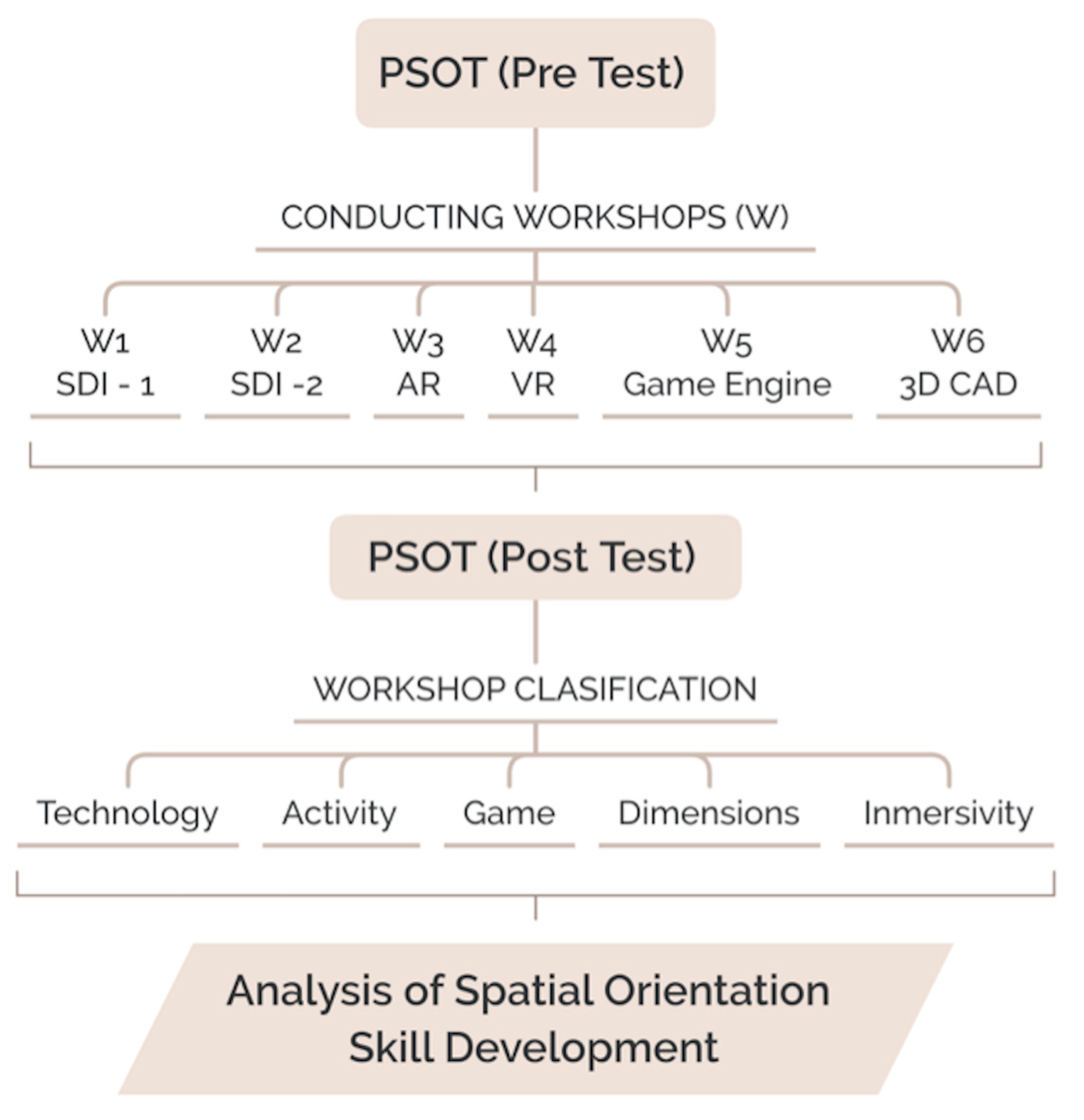
2.3. Workshops Classifications: Technology, Aactivity, Games, Dimensions, and Immersivity

The technologies used in these workshops included Spatial Data Infrastructure geoportal (SDI), augmented reality technology (AR), virtual reality (VR) with virtual reality glasses, the Unity game engine (used for 3D terrain modeling), and Computer-Aided Design (CAD) (applications such as Cad Mapper combined with SketchUp and Street View applications). In landscape architecture, maps, as well as geospatial technologies, such as Google Earth, Google Maps, the Street View Service of Google Maps, and GIS (Geographic Information Systems), have been used for the identification and classification of the landscape [46,47]. Therefore, a wide spectrum of technologies is involved, ranging from applications like SDI, to 2D and 3D rendering environments, video games, and virtual reality environments.
Regarding the kind of activity, spatial orientation skills are necessary for navigation tasks in the environment to orient ourselves when we move in space and when we use maps or geospatial information [30,48,49]. Tartre [25] and Golledge et al. [50] list two main sources of geospatial thinking acquisition: route-based learning (ground level), also called navigation or wayfinding, and aerial or map like perspectives (survey learning or map learning). The term “route-based learning” is also known as “exploratory navigation” or wayfinding. This refers to movement through space in a certain environment where we need to orient ourselves. This orientation is accomplished through local information from different views—that is, by acquiring information during movement and not using geographic north, as with a map. Spatial learning, through route-based learning, is acquired from the perspective of the observer at ground level. In contrast, from an aerial or map-like perspective, spatial references are acquired from the aerial vantage point used by maps [51]. Space is perceived from a fixed orientation—the north of the map [52]. This is why some authors also call this process “survey learning” or “map learning” [53]. When using a map, the orientation of the elements that appear on that map is perceived relative to known links. To orient using a map, we need to orient the map in space [54].
Therefore, activities related to the two sources of spatial orientation skill acquisition were conducted: survey learning and/or wayfinding (or combining both). The use of strategies based on one or the other activity, or combined learning strategies between the two, is an active field in the recent research on training and improving spatial orientation [5,55,56].
Game environments have shown potential for the development of spatial skills and have also been studied accordingly. Many researchers have proposed using a 3D perspective based on 2D representations [57,58,59], such as the perception of the landscape starting from a map with contour lines. Previous research concluded that a 2D and 3D combination is useful for precise orientation and position tasks [60]. Therefore, 2D and 3D displays, along with 2D/3D combination displays, were employed in the workshops. It is also important to analyze the impacts of VLEs (Virtual learning environments) through virtual reality technology, which can provide immersion. The classifications of the workshops are shown in Table 1.
A common denominator enables comparisons between all of these previous studies: All studies used the perspective-taking spatial orientation test [43,44]. Furthermore, all the students participating in this study were from the same engineering course. This allows for a cross-sectional examination based on quantitative data to determine which strategies, technologies, or teaching–learning environments are the most suitable for training and improving spatial orientation skills.

2.4. Data Processing

The gains obtained in the Perspective Taking-Spatial Orientation Test Score were computed as the difference between the Pre- and the Post-Workshop Score. The percentages that the gains represent of the maximum score from the Perspective Taking-Spatial Orientation Test were also computed to clarify the results. The obtained data were subjected to descriptive analyses and ANOVAs (ANalysis Of VAriance) after a Levene test of variance due disparity of sample sizes (n). In all statistical tests, the level of significance was set at 0.05. The statistical analyses were performed using SPSS v.21.0. [61]. For the SPSS Research Data, see supplementary material.

3. Workshops

The SDI_1 and SDI_2 workshops [62,63] were held with the Canary Islands Spatial Data Infrastructure (SDI) geoportal since the Canary Islands were the geographical environment where the research was carried out. In the AR workshop, augmented reality technology was used [64]. In the VR workshop, virtual reality was used with virtual reality glasses [65]. To study a video game environment, a Unity workshop was carried out with the game engine Unity [66]. Finally, 3D modeling CAD applications like CadMapper were used together with the SketchUp application [67].
The full description of each of these workshops can be found in the indicated sources. A brief description of each of the workshops is provided below.

3.1. SDI_1 and SDI_2 Workshops

Recent research has underlined the important role that Spatial Data Infrastructure (SDI) plays in landscape architecture [10,68,69]. Spatial data infrastructures are geoportals that offer the user a series of resources (geographic information servers, applications, links, etc.) for querying geospatial information. They offer online map interfaces in which geospatial information can be consulted in different formats, such as orthophotos, cartography at different scales, and satellite images (to name a few). In addition, they allow access to geographically referenced thematic information databases. Organizations like the Computer Research Association recommend the use of SDIs for teaching–learning processes in STEM disciplines [70].
The SDI workshops worked with different representations of landforms. In both (SDI_1 and SDI_2) workshops, there were two phases: (1) introductory and (2) improvement. In the introductory phase, participants were instructed on the use of the geoportal, its main commands, and its functions. In the improvement phase, in the SDI_1 workshop, participants carried out survey learning activities related to spatial orientation exercises using 2D landform maps. In the SDI_2 workshop, the approach was to work with spatial orientation, combining survey learning and wayfinding activities using landforms. Not only 2D maps but also 3D perspectives were used to allow each student to engage in a navigation experience at ground level, as if they were walking directly on the ground.
Previous works in the field of landscape architecture education use maps and geospatial applications. Meireles and Loures [71] developed a strategy based on PBL (Project-Baed Learning) as part of a landscape architecture bachelor design studio for the redesign of public spaces. In this work, the authors used maps and Quantum GIS software. They also used a PBL-based strategy to study the personal skills (communication, collaborative, self-learning, etc.) of the landscape architecture students [72] but not their spatial skills, as analyzed in the present research.

3.2. Augmented Reality Workshop

Augmented reality is a powerful tool that that offers great possibilities in landscape architecture education and professional settings. Kerr and Lawson [68] worked with augmented reality (AR) in a mobile blended learning experiment for landscape architecture students. Also using AR, Schroth and Zhanf [73] developed an educational tool to help landscape architecture students read contour lines maps. Konopacki [74] used AR for visual reconstructions of architectural and landscape designs.
In our workshop, participants determined locations and routes based on interpretations of landforms represented in 2D and 3D. The 2D representations were maps featuring contour lines with different landforms, such as maximum slope lines, depressions, slopes, hills, etc. With augmented reality, the landforms were represented in 3D through the recognition of a marker on a 2D map using a camera, thereby obtaining a digital model of the terrain in 3D. The students needed to use their spatial orientation skills to make a 2D/3D interpretation by visualizing the appearance of the scenes from different strategic points with conventional 2D and AR representations.

3.3. Virtual Reality Immersive Workshop

The participants navigated an urban Virtual Environment using VR glasses and a motion sensor. The motion sensor (joystick) allowed the user to move around the environment (exploratory navigation). Students applied their spatial orientation skills through exploratory navigation from a ground-level perspective using landmarks in an urban environment instead of landforms. They experimented using immersive sensations in an urban landscape architecture environment.

3.4. Game Engine

The positive effects that games have on the development of spatial skills have been the subject of numerous studies [75,76,77]. In this workshop, the students practiced engaging in landscape architecture with landforms. In the first phase, the students received training on the representation of landforms with contour line maps and 2D orthophotos. Then, using the Unity game engine, participants designed an environment in which they modeled different five landforms in 3D. The participants had to describe, with respect to the cardinal points, the position/location (N, S, E, W) of each of the landforms with respect to the others from their current position/perspective. For this, the students used the position of the Sun, also represented in the scenario. The first-person character controller offered by Unity allowed the user to travel the terrain and visualize the whole scenario as if he or she were there. Using this view, the terrain was not shown from an aerial view, as is usually the case on maps. The environment was visualized as it would be if the participants were in a real environment using their first-person perspective (wayfinding). Participants designed their cardinal locations by recording a first-person perspective virtual tour. In addition to these characteristic orientation activities, this player perspective is effective for the development of spatial skills [78].

3.5. 3D CAD Applications

Cad Mapper is a 3D digital mapping repository that, together with the 3D CAD application SketchUp, was used in an urban landscape architecture activity based on green infrastructure (vertical gardens). Green infrastructures are green spaces intended to improve environmental conditions, as well as the health and quality of life of citizens [79]. For this reason, exposure to the sun of vertical gardens is an important factor to consider. Students had to account for the cardinal orientation (N, S, E, W) of buildings according to their shadows, depending on the different positions of the sun throughout the day. The position of the sun allows one to optimize the thermal performance of the vertical gardens in buildings and to analyze the influence of meteorological factors on its thermal performance.

4. Results

In order to determine the differences in gains according to the different methods of classification used for the workshops, an ANOVA was performed for each classification. Table 2 shows the descriptive and ANOVA statistics of gains, according to the five methods of classification. In order to clarify the value of the gains, these gains were also described as a percentage. The percentage data, therefore, represent the percentage with respect to the maximum score of the Perspective Taking-Spatial Orientation Test.
There is a great disparity in the sample sizes (n). If the variances are equal or the greater variance is in the larger group, a different n value would not affect the contrast. Levene’s test of variance was only significant in the case of Immersion, but the variance of the Non-Immersive group was greater than the variance of the smaller Immersive group. Therefore, the disparity of n is not an obstacle to performing an ANOVA analysis.
All classifications (except for No game/Game) present significant differences in their gains (see Table 2 for ANOVA statistics and p). That is, there are no significant differences between game-based environments and non-game-based ones.
For technology, as shown in Figure 2, AR and SDI achieved the highest gains. The post hoc analyses revealed that virtual reality and 3D CAD applications achieved significantly fewer gains than AR, SDI_1, or SDI_2 (p < 0.05). VR (Gain = 12.8, 14.2%) provided 8.14% fewer gains than AR (Gain = 20.1, 22.4%), 7.11% fewer gains than SDI_1 (Gain = 19.2, 21.3%) and 6.94% fewer gains than SDI_2 (Gain = 19.1, 21.2%). The 3D CAD applications (Gain = 12.8, 14.3%) had 8.12%, 7.09%, and 6.92% fewer gains than AR, SDI_1, and SDI_2, respectively.
If the activity included survey learning (with or without wayfinding), the gain was significantly greater (p < 0.05) than that for only wayfinding (Figure 3). Survey learning (Gain = 19.2, 21.3%) had 7.10% more gains than wayfinding (Gain = 12.8, 14.2%) and survey learning, and wayfinding (Gain = 18.8, 20.9%) had 6.64% more gains than only wayfinding.
For the number of dimensions included in the workshops, as shown in Figure 4, 2D (with or without 3D) tasks provided significantly better results than only 3D (p < 0.05). Alone, 2D (Gain = 19.2, 21.3%) offered 7.10% more gains than 3D (Gain = 12.8, 14.2%), while 2D and 3D (Gain = 18.8, 20.9%) had 6.64% more gains than only 3D.
Finally, gains as a function of Immersion are displayed in Figure 5. No immersive workshops (Gain = 18.6, 20.7%) had 6.47% greater gains than immersive ones (Gain = 12.8, 14.2%).

5. Discussion

Five factors were considered in the study: game/no game, technology (SDI_1, SDI_2, augmented reality, virtual reality, game engine and 3D CAD apps.), activity (survey learning, wayfinding), 2D/3D graphic environments and, finally, immersive or non-immersive environments.

5.1. Game/No Game Environments
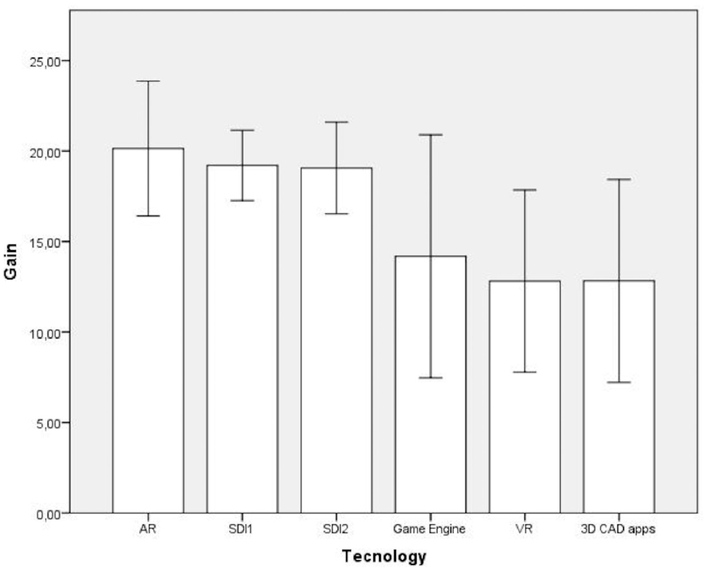
There were no significant differences found between game-based environments and non-game-based ones. Therefore, game-based environments can be considered an alternative strategy for the development of spatial orientation skills. In the field of the development of spatial skills with gaming environments, other authors agree with this statement, stressing that "several different forms (game environments) of training can be highly successful" [77]. The results of the strategy based on a gaming environment showed an improvement in spatial orientation skills, which agrees with the results of David [76]. In this sense, the role of the motivation engendered by games can help facilitate spatial orientation training, both for students and professionals. Regarding the type of game, Klazky [80] highlighted the importance of the player’s perspective in the development of spatial skills. Keeping this in mind, in the present research, the game-based environment used the Unity game engine. The participants toured a territory where they had previously designed different landforms and carried out spatial orientation activities. In this tour, control of the movement direction offered the students different visual landscapes coinciding with the player’s viewpoint. This characteristic (that is, the similarity between the perception of the game environment and the corresponding real environment) can facilitate the development of spatial orientation skills. In other types of games, such as Tetris, the movement controls do not match a player-centered point of view. Thus, such games develop other types of spatial skills, such as mental rotation [78].

5.2. Technology

The post hoc analyses revealed that VR and 3D CAD applications achieved significantly fewer gains than AR, SDI_1, or SDI_2 (p < 0.05). VR (Gain = 12.81, 14.2%) had 8.14% fewer gains than AR (Gain = 20.14, 22.4%), which had 7.11% fewer gains than SDI_1 (Gain = 19.21, 21.3%) and 6.94% fewer gains than SDI_2 (Gain = 19.06, 21.2%). The 3D CAD applications (Gain = 12.83, 14.3%) had 8.12%, 7.09%, and 6.92% fewer gains that AR, SDI_1, and SDI_2, respectively.
Of the six technologies used in the study (SDI_1, SDI_2, augmented reality, virtual reality, game engine, and 3D CAD applications), two of them showed significantly lower gains than the rest: Virtual Reality and CAD applications. Virtual Reality had 8.14%, 7.11%, and 6.94% fewer gains than those obtained using AR, SDI_1, and SDI_2, respectively. However, the great variability of the VR workshop data used in this study could be a limitation. In the workshop with 3D CAD applications, the gains obtained were also 8.12%, 7.09%, and 6.92% lower than those in the workshops performed with AR, SDI_1, and SDI_2.
Considering previous studies, Waller et al. [81] also noted the lower performance of VR for the development of spatial orientation. However, since the date of that study, virtual reality has experienced great advances. Other authors, such as Roca-González et al. (from F20), have obtained results similar to those obtained in this study with Augmented Reality, SDI_1, and SDI_2 in spatial orientation gains, combining VR-based strategies with map-based strategies. Regarding the use of 3D CAD applications, the Cad Mapper 3D digital mapping repository together with the 3D CAD application SketchUp were used in our research. CAD applications are an effective tool to engage in spatial skill acquisition strategies [82].

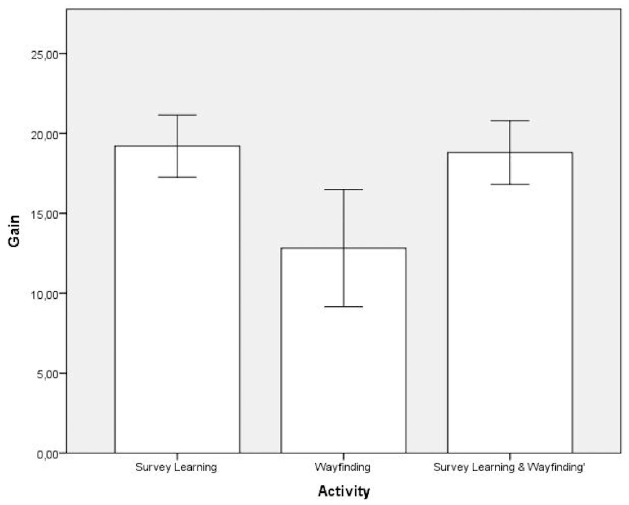
5.3. Activity: Survey Learning/Wayfinding

Survey learning and wayfinding are the two main sources of spatial orientation skill acquisition. The results indicate that survey learning-type activities are 7.1% more effective in developing spatial orientation skill than wayfinding-based strategies. A strategy combining the two types of activities (survey learning and wayfinding) is 6.64% more effective than a spatial orientation skill development strategy based exclusively on wayfinding. Traditional maps remain an important tool linked to spatial orientation. Activities that use maps for the development of spatial orientation, both those with maps alone and those combining maps with wayfinding activities, continue to be employed for this purpose.
Considering previous studies, recent research (such as that carried out by Carbonell, Shipley, and Jaeger [56]) also concluded that maps remain a powerful tool for the development of spatial thinking. Regarding the combined use of the two activities, Chaloupska et al. [5] stated the need to establish a blended learning model that includes map reading and wayfinding activities for spatial skill training and development.
Therefore, the type of activity (survey learning or wayfinding) is highly relevant. Orientation tasks that use maps (survey learning) are more efficient for the development of spatial orientation than tasks related to wayfinding. Combined survey learning and wayfinding strategies also provide better results than those carried out exclusively with wayfinding.

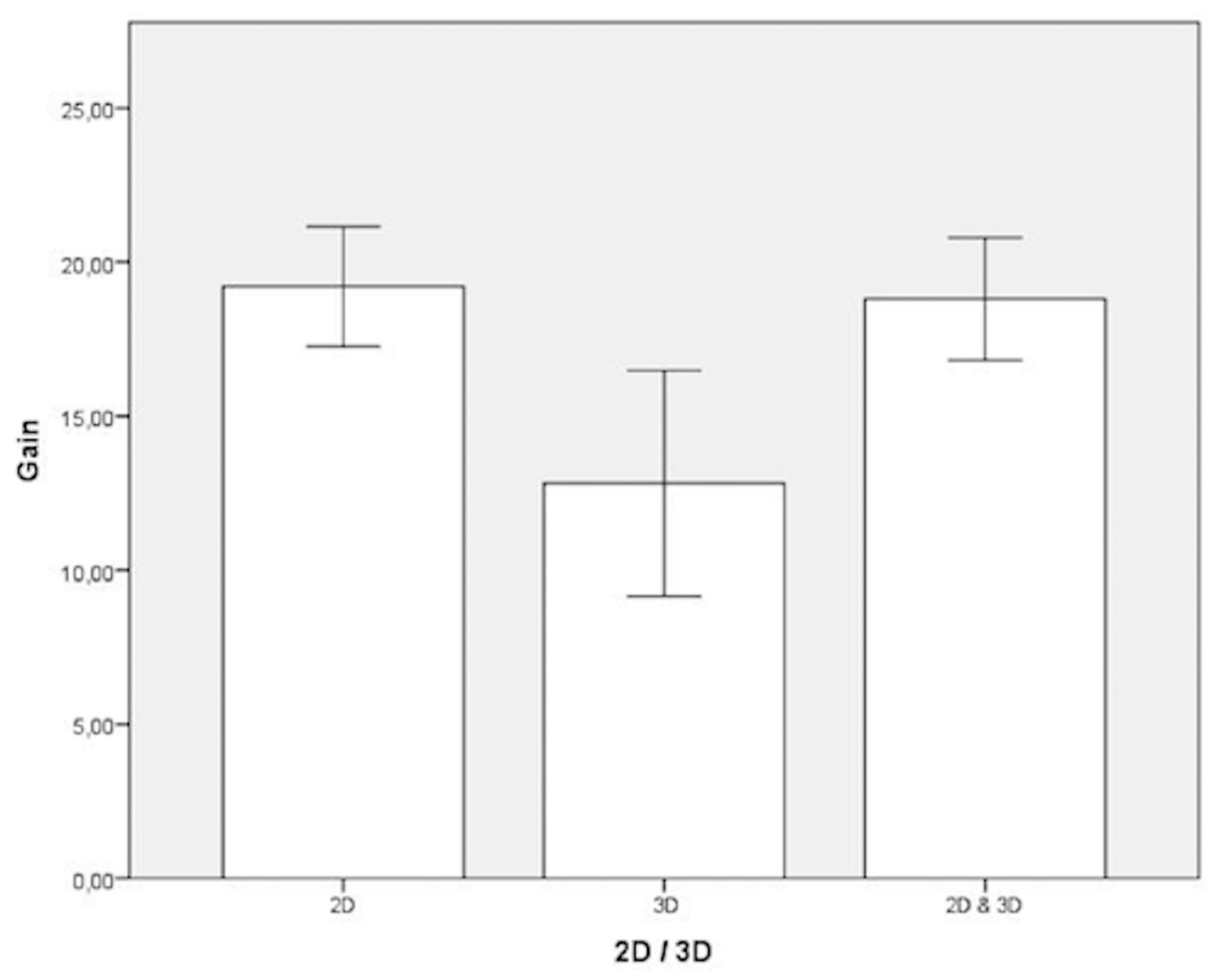
5.4. Diemsions: 2D/3D

In the six workshops covered in this research, some activities were carried out in 2D and some in 3D. The 2D and 3D activities were also combined in the same workshop. The 2D activities (with or without 3D) produced better results than those using only 3D. The 2D activities had 7.10% greater gains in spatial orientation skill development than those using 3D, and the combined 2D and 3D strategy obtained 6.64% more gains compared to the strategies that only used 3D. These results highlight the convenience of using traditional exercises with 2D maps while also combining 2D and 3D for the improvement of spatial orientation skills instead of using 3D-only strategies. Tory et al. [60] also opted for a 2D/3D combination for precise orientation and position tasks.
This choice coincides with the type of technology. Strategies carried out with geoportals that offer 2D maps, such as Spatial data infrastructures, are efficient for the development of spatial orientation. Blended strategies using maps (2D) and AR (3D) alongside the two types of activities (survey learning and wayfinding) have demonstrated their potential for the development of spatial orientation skills.

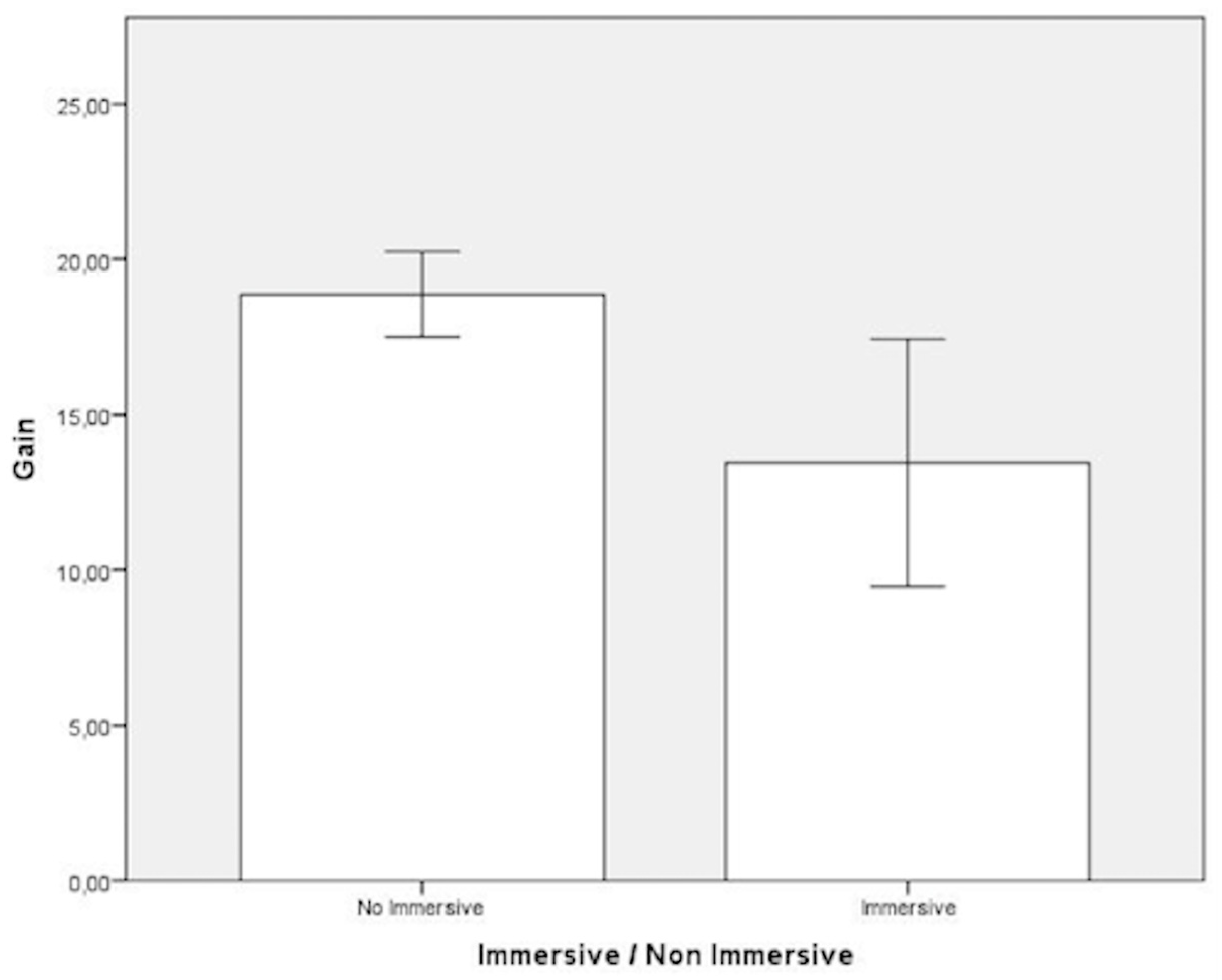
5.5. Immersive or Non-Immersive Environments

The results show that the gain in spatial orientation is 6.47% higher when using non-immersive rather than immersive environments, although the data on the virtual reality workshop in our study have very high variability, which could be a limitation. Compared to previous studies, virtual reality showed lower (although not significantly lower) results in spatial orientation gains than other strategies based on non-immersive environments using 3D tools and maps [65]. Again, the use of maps was shown to be an important factor for the development of spatial orientation skills.
For the measurement of spatial orientation skills in immersive environments, some authors recommend using the 3D Perspective-Taking Test instead of the 2D versions [83], such as the one used in the present study. This question could be a determining factor for analyzing the impact of virtual environments based on spatial orientation skills, thus giving rise to a future research direction. Future research that addresses this topic is necessary given the great possibilities offered by virtual reality in the field of landscape architecture.

6. Conclusions

Professional landscape architecture organizations have requested training from educational institutions based on new skills and methodologies for the curriculum development of students. In this sense, many studies emphasize the importance of spatial orientation skills in landscape architecture, both in the academic and professional fields, as well as strategies for relevant training. Spatial orientation skills can be developed through specific training strategies, but different strategies offer different results. Determining which strategies are most appropriate for training and improving spatial orientation skills is necessary for landscape architects. The present research used different strategies, taking into account several factors that intervene in orientation tasks, such as the technology used, the use of gaming or non-gaming environments, the type of activity (orientation task), the use of a two-dimensional or three-dimensional environment, and the use of virtual reality environments.
The results of this analysis indicate that there is no single strategy that is best. Rather, different factors determine a strategy’s suitability for the development of spatial orientation skills.
In relation to the type of activity and the use of 2D/3D representations, survey learning activities are more effective than wayfinding activities, just as 2D representations offer better results than 3D ones. Interestingly, the blended strategies combining these factors were shown to be the most efficient—that is, strategies that combine survey learning and wayfinding activities or that combine 2D maps and 3D representations. The same is true for technology, where a combination of 2D and 3D technologies was the best option.
Gaming environments also offer great possibilities and can be considered a valid alternative. It is necessary to emphasize that, given the great variety of gaming environments, those that offer the player a first-person perspective are the most suitable for the development of spatial orientation skills. Blended strategies are again important here. In the present research, the strategy carried out using a first-person gaming environment was also combined; 2D and 3D environments were used alongside survey learning and wayfinding activities.
Immersive environments were somewhat less efficient than non-immersive environments for the development of spatial orientation skills, although the limitations of our study (its great variability and measurement tools) preclude a definitive conclusion in this area.
The technologies used in this study are easy to use and free; they do not require extensive specific software training. The test used to measure spatial orientation was, for example, provided through a web address where it can be downloaded. This makes it possible to carry out an interdisciplinary approach that covers both the field of education and the professional practice of landscape architecture, since the workshops described can also be easily carried out in professional settings.

Supplementary Materials

The following are available online at https://www.mdpi.com/2073-445X/9/5/161/s1: SPSS Research Data.

Author Contributions

Conceptualization, C.C.-C., J.L.S., and S.H.-M.; methodology, S.H.-M.; software, J.L.S.; validation, C.C.-C. and S.H.-M.; formal analysis, S.H.-M.; investigation, C.C.-C.; resources, C.C.-C., and J.L.S.; data curation, C.C.-C., J.L.S., and S.H.-M.; writing—original draft preparation, C.C.-C.; writing—review and editing, C.C.-C., J.L.S. and S.H.-M.; visualization, J.L.S.; supervision, J.L.S. and S.H.-M.; project administration, C.C.-C.; funding acquisition, C.C.-C. All authors have read and agreed to the published version of the manuscript.

Funding

Spanish Ministry of Education, Culture and Sport, within the framework of the State Program for the Promotion of Talent and its Employability in I+D+I: the State Mobility Subprogram of the State Plan for Scientific and Technical Research and Innovation 20: CAS18/00033. Resolution: 10 August 2018.

Acknowledgments

The authors appreciate the work of the editor and the reviewers.

Conflicts of Interest

The authors declare no conflict of interest.

References

  1. Liu, M.; Nijhuis, S. Mapping landscape spaces: Methods for Unerstanding Spatial-Visual Characteristics in Landscape Design. Environ. Impact Assess. Rev. 2020, 82, 106376. [Google Scholar] [CrossRef]
  2. Kara, B. Landscape Design and Cognitive Psychology. Procedia Soc. Behav. Sci. 2012, 82, 288–291. [Google Scholar] [CrossRef] [Green Version]
  3. Burley, J.B. The Emergence of Landscape Urbanism: A Chronological Criticism Essay. Land 2018, 7, 147. [Google Scholar] [CrossRef] [Green Version]
  4. Kastuari, A.; Sewahardhi, D.; Hanan, H.; Wikantika, K. State of the Art of the Landscape Architecture Spatial Data Model from a Geospatial Perspective. In Proceedings of the ISPRS Annals of the Photogrammetry, Remote Sensing and Spatial Information Sciences, Volume IV-2/W1, 2016 11th 3D Geoinfo Conference, Athens, Greece, 20–21 October 2016. [Google Scholar]
  5. Chaloupska, P.; Hrusova, D.; Chaloupsky, D. Possibilities of Blended Learning to Develop Orientation and Navigation Skills of Tourism Management Students. In Advances in Web-Based Learning—ICWL 2019. ICWL 2019, Proceedings of the 18th International Conference, Magdeburg, Germany, 23–25 September 2019; Herzog, M., Kubincová, Z., Han, P., Temperini, M., Eds.; Springer: Cham, Switzerland, 2019. [Google Scholar]
  6. National Research Council. Learning to Think Spatially; The National Academies Press: Washington, DC, USA, 2006; pp. 25–48. [Google Scholar] [CrossRef]
  7. Nielsen, C.P.; Oberle, A.; Sugumaran, R. Implementing a High School Level Geospatial Technologies and Spatial Thinking Course. J. Geogr. 2011, 110, 60–69. [Google Scholar] [CrossRef]
  8. Akinci, A.; Akinci, C. The Importance of Spatial Ability Research: The Case of Landscape Architecture Education. In Environmental Sustainability and Landscape Management; Efe, R., Gad, A., Cürebal, I., Tóth, B., Eds.; St. Kliment Ohridski University Press: Sofia, Greece, 2016; pp. 535–545. [Google Scholar]
  9. Cho, J.Y. Spatial Ability, Creativity, and Studio Performance in Architectural Design. In Proceedings of the 17th International Conference on Computer-Aided Architectural Design Research in Asia, Hong Kong, China, 25–28 April 2012; pp. 131–140. [Google Scholar]
  10. Sinton, D. Spatial Learning in Higher Education. In Space in Mind. Concepts for Spatial Learning and Education; Montello, D.R., Grossner, K., Janelle, D.G., Eds.; The MIT Press: Cambridge, MA, USA, 2014; pp. 222–239. [Google Scholar]
  11. Tulla, A. Libro Blanco del Título de Grado en Geografía y Ordenación del Territorio; ANECA: Madrid, España, 2004. Available online: http://www.aneca.es/var/media/150444/libroblanco_jun05_geografia.pdf (accessed on 10 April 2020).
  12. Rúa, E. (coord.) Libro Blanco del Título de Grado en Ingeniería Civil; ANECA: Madrid, España, 2004. Available online: http://www.aneca.es/var/media/150320/libroblanco_ingcivil_def.pdf (accessed on 10 April 2020).
  13. Hernández León, J.M. (coord.) Libro Blanco del Título de Grado en Arquitectura; ANECA: Madrid, España, 2005. Available online: http://www.aneca.es/var/media/326200/libroblanco_arquitectura_def.pdf (accessed on 10 April 2020).
  14. Sastre Merlin, A. (coord.) Libro Blanco del Título de Grado en Ciencias Ambientales; ANECA: Madrid, España, 2004. Available online: http://www.aneca.es/var/media/150340/libroblanco_ambientales_def.pdf (accessed on 9 May 2020).
  15. Alcalde García, M. (coord.) Libro Blanco del Título de Grado en Ingenierías Agrarias e Ingenierías Forestales; ANECA: Madrid, España, 2005. Available online: http://www.aneca.es/var/media/150348/libroblanco_agrarias_forestales_def.pdf (accessed on 9 May 2020).
  16. Chen, X. STEM Attrition: College Students’ Paths into and Out of STEM Fields. Statistical Analysis Report; NCES 2014-001; US Department of Education: Washington, DC, USA, 2013.
  17. Higher Education Research Institute. Degrees of Success: Bachelor’s Degree Completion Rates among Initial STEM Majors. Research Brief; University of California: Los Angeles, CA, USA, 2010. [Google Scholar]
  18. Maier, P. Spatial Geometry and Spatial Ability: How to Make Solid Geometry Solid. In Proceedings of the Annual Conference of Didactics of Mathematics (GDM), Regensburg, Germany, 4–8 March 1996; pp. 69–81. [Google Scholar]
  19. Smith, I.M. Spatial Ability: Its Educational and Social Significance; University of London Press: London, UK, 1964. [Google Scholar]
  20. Linn, M.C.; Petersen, A.C. Emergence and Characterization of Sex Differences in Spatial Ability: A Meta-Analysis. Child Dev. 1985, 56, 1479–1498. [Google Scholar] [CrossRef] [PubMed]
  21. Sorby, S.A. Developing 3-D Spatial Visualization Skills. Eng. Des. Graph. J. 2009, 63, 21–32. [Google Scholar]
  22. Marunic, G.; Glažar, V. Improvement and Assessment of Spatial Ability in Engineering Education. Eng. Rev. 2014, 34, 139–150. [Google Scholar]
  23. Weckbacher, L.M.; Okamoto, Y. Mental Rotation Ability in Relation to Self-Perceptions of High School Geometry. Learn. Individ. Differ. 2014, 30, 58–63. [Google Scholar] [CrossRef]
  24. Bodner, G.; Guay, R. The Purdue Visualization of Rotations Test. Chem. Edu. 1997, 2, 1–18. [Google Scholar] [CrossRef]
  25. Tartre, L.A. Spatial Orientation Skill and Mathematical Problem Solving. J. Res Math. Educ. 1990, 21, 216–229. [Google Scholar] [CrossRef]
  26. Krejči, M.; Hradilová, I. Spatial Orientation in the Urban Space in Relation to Landscape Architecture. Acta Univ. Agric. Silvic. Medelianae Brun. 2014, 62, 545–552. [Google Scholar] [CrossRef] [Green Version]
  27. Krejči, M.; Hradilová, I. Landscape Infographic Design. Eur. Sci. J. 2014, 2, 397–401. [Google Scholar]
  28. Jorgensen, K.; Karadeniz, N.; Mertents, E.; Stiles, R. The Routledge Handbook of Teaching Landscape; Routledge: New York, NY, USA, 2019; pp. 276–289. [Google Scholar]
  29. Spanish Cabinet’s Office. Royal Decree 1513/2006 from 7 December. State’s Official Bulletin. 2006. Available online: http://www.boe.es/boe/dias/2006/12/08/pdfs/A43053-43102.pdf (accessed on 1 September 2017).
  30. Gonzato, M.; Godino, J.D. Aspectos Históricos, Sociales y Educativos de la Orientación Espacial. Unión Rev. Iberoam. Mat. 2011, 23, 24–45. [Google Scholar]
  31. Ministerio de Ciencia e Innovación, Planes de Estudio, Habilitación Profesional, Boletín Oficial del Estado, 42, 18 de Febrero de 2009, Spain. Available online: http://www.boe.es/boe/dias/2009/02/18/ (accessed on 10 April 2020).
  32. Ministerio de Ciencia e Innovación, Planes de Estudio, habilitación Profesional, Boletín Oficial del Estado, 43, 19 de Febrero de 2009, Spain. Available online: http://www.boe.es/boe/dias/2009/02/19/ (accessed on 10 April 2020).
  33. Ministerio de Ciencia e Innovación, Planes de Estudio, Habilitación Profesional, Boletín Oficial del Estado, 44, 20 de Febrero de 2009, Spain. Available online: http://www.boe.es/boe/dias/2009/02/20/ (accessed on 10 April 2020).
  34. National Council of Teachers of Mathematics. Principles and Standards for School Mathematics; NCTM: Reston, VA, USA, 2000. [Google Scholar]
  35. Presmeg, N.C. Research on Visualization in Learning and Teaching Mathematics: Emergence from Psychology. In Handbook of Research on the Psychology of Mathematics Education; Gutiérrez, A., Boero, P., Eds.; Sense Publishers: Dordrecht, The Netherlands, 2006. [Google Scholar]
  36. Battista, M.T. The Development of Geometric and Spatial Thinking. In Second Handbook of Research on Mathematics Teaching and Learning; Lester, F.K., Charlotte, N.C., Eds.; Information Age Publishing: Charlotte, NC, USA, 2007; pp. 843–908. [Google Scholar]
  37. Gutiérrez, A. Childern’s Ability for Using Different Plane Representations of Space Figures. In New Directions in Geometry Education; Baturro, A.R., Ed.; Centre of Math and Sc. Education, Q.U.T.: Brisbane, Australia, 1996; pp. 33–42. [Google Scholar]
  38. Kinsey, B. Design of a CAD Integrated Physical Model Rotator. In Proceedings of the Annual Conference & Exposition Engineering Education, Nashville, TN, USA, 22–25 June 2003; American Society of Engineering Education: Washington, DC, USA, 2003. [Google Scholar]
  39. Newcomer, J.; Raudebaugh, R.; McKell, E.; Kelley, D. Visualization, Freehand Drawing, Solid Modeling, and Design in Introductory Engineering Graphics. In Proceedings of the 29th ASEE/IEEE Frontiers in Education Conference, San Juan, Puerto Rico, 10–13 November 1999. [Google Scholar]
  40. Reber, A.S. Dictionary of Psychology; Penguin Books Ltd.: London, UK, 2009. [Google Scholar]
  41. Sorby, S.; Wysocki, A.; Baartmants, B. Introduction to 3D Spatial Visualization: An Active Approach; Thomson Delmar Learning: Clifton Park, NY, USA, 2003. [Google Scholar]
  42. Cohen, C.A.; Hegarty, M.; Keehner, M.; Montello, D.R. Spatial Ability in the Representation of Cross Sections. In Proceedings of the 25th Annual Conference of the Cognitive Science Society, Boston, MA, USA, 31 July–2 August 2003; pp. 1333–1334. [Google Scholar]
  43. Hegarty, M.; Waller, D. A Dissociation between Mental Rotation and Perspective-Taking Spatial Abilities. Intelligence 2004, 32, 175–191. [Google Scholar] [CrossRef]
  44. Kozhevnikov, M.; Hegarty, M. A Dissociation between Object Manipulation, Spatial Ability and Spatial Orientation Ability. Mem. Cogn. 2001, 29, 745–756. [Google Scholar] [CrossRef]
  45. Harvey, K. Landmarks in the Landscape: Historic Architecture in the National Parks of the West; Chronicie Books: San Francisco, CA, USA, 1997. [Google Scholar]
  46. De Sousa Silva, C.; Viegas, I.; Panagopoulos, Τ.; Bell, S. Environmental Justice in Accessibility to Green Infrastructure in Two European Cities. Land 2018, 7, 134. [Google Scholar] [CrossRef] [Green Version]
  47. Christman, Z.; Meenar, M.; Mandarano, L.; Hearing, K. Prioritizing Suitable Locations for Green Stormwater Infrastructure Based on Social Factors in Philadelphia. Land 2018, 7, 145. [Google Scholar] [CrossRef] [Green Version]
  48. Hill, K.A. Lost Person Behavior; National SAR Secretariat: Ottawa, ON, Canada, 1998.
  49. Howard, I.P.; Templeton, W.B. Human Spatial Orientation; Wiley: London, UK, 1966. [Google Scholar]
  50. Golledge, R.G.; Dougherty, V.; Bell, S. Survey Versus Route-Based Wayfinding in Unfamiliar Environments; Working Papers; University of California Transportation Center: Berkeley, CA, USA, 1993; pp. 1–36. [Google Scholar]
  51. Fields, A.W.; Shelton, A.L. Individual Skill Differences and Large-Scale Environmental Learning. J. Exp. Psychol. Learn. Mem. Cogn. 2006, 32, 506–515. [Google Scholar] [CrossRef]
  52. Shelton, A.L.; McNamara, T.P. Orientation and Perspective Dependence in Route and Survey Learning. J. Exp. Psychol. Learn. Mem. Cogn. 2004, 30, 158–170. [Google Scholar] [CrossRef] [Green Version]
  53. Shelton, A.L.; Gabrieli, J.D.E. Neural Correlates of Individual Differences in Spatial Learning Strategies. Neuropsychology 2004, 18, 442–449. [Google Scholar] [CrossRef] [Green Version]
  54. Gálvez, G. El Aprendizaje de la Orientación en el Espacio Urbano: Una Proposición Para la Enseñanza de la Geometría en la Escuela Primaria. Master’s Thesis, Centro de Investigación del IPN, Ciudad de Mexico D.F., Mexico, 1985. [Google Scholar]
  55. Carbonell-Carrera, C.; Saorin, J.L.; Hess-Medler, S. Pokémon Go and Imprivement in Spatial Orientation Skills. Prof. Geograph. 2018, 117, 245. [Google Scholar]
  56. Carbonell-Carrera, C.; Jaeger, A.J.; Shipley, T.F. 2D Cartography Training: Has the Time Come for a Paradigm Shift? ISPRS Int. J. Geo-Inf. 2018, 7, 197. [Google Scholar] [CrossRef] [Green Version]
  57. Liao, K. The Abilities of Understanding Spatial Relations, Spatial Orientation, and Spatial Visualization Affect 3D Productdesign Performance: Using Carton Box design as an Example. Int. J. Technol. Des. Educ. 2017, 27, 131–147. [Google Scholar] [CrossRef]
  58. Macnab, W.; Johnstone, A.H. Spatial Skills Which Contribute to Competence in the Biological Science. J. Biol. Educ. 1990, 24, 37–41. [Google Scholar] [CrossRef]
  59. Lohman, D. Spatial Abilities as Traits, Processes, and Knowledge. In Advances in the Psychology of Human Intelligence; Sternberg, R.J., Ed.; Lawrence Erlbaum: Hillsdale, NJ, USA, 1988; pp. 181–248. [Google Scholar]
  60. Tory, M.; Möller, T.; Atkins, M.S.; Kirkpatrick, A. Combining 2D and 3D Views for Orientation and Relative Position Tasks. In Proceedings of the SIGCHI Conference on Human Factors in Computing Systems, Vienna, Austria, 24–29 April 2004; pp. 73–80. [Google Scholar] [CrossRef]
  61. George, D.; Mallery, M. SPSS Statistics 23 Step by Step: A Simple Guide and Reference; Routledge Taylor and Francis: New York, NY, USA, 2016. [Google Scholar]
  62. Carbonell, C. Spatial-Thinking Knowledge Acquisition from Route-Based Learning and Survey Learning: Improvement of Spatial Orientation Skill with Geographic Information Science Sources. J. Surv. Eng. 2017, 6, 143. [Google Scholar] [CrossRef]
  63. Carbonell-Carrera, C.; Hess-Medler, S. Spatial Orientation Skill Improvement with Geo-spatial Applications: Report of a Multi-Year Study. ISPRS Int. J. Geo-Inf. 2017, 6, 278. [Google Scholar] [CrossRef] [Green Version]
  64. Carbonell, C.; Bermejo, L.A. Augmented Reality as a Digital Teaching Environment to Develop Spatial Thinking. Cartogr. Geogr. Inf. Sci. 2017, 44, 259–270. [Google Scholar] [CrossRef]
  65. Carbonell-Carrera, C.; Saorin, J.L. Virtual Learning Environments to Enhance Spatial Orientation. Eur. J. Math. Sci. Technol. Ed. 2018, 14, 709–719. [Google Scholar] [CrossRef]
  66. Carbonell-Carrera, C.; Gunalp, P.; Saorin, J.L.; Hess-Medler, S. Think Spatially With Game Engine. ISPRS Int. J. Geoinf. 2020, 9, 159. [Google Scholar] [CrossRef] [Green Version]
  67. Carbonell-Carrera, C.; Saorin, J.L.; Melián-Díaz, D.; Hess-Medler, S. Spatial Orientation Skill Performance with a Workshop Based on Green Infrastructure in Cities. ISPRS Int. J. Geoinf. 2020, 9, 216. [Google Scholar] [CrossRef] [Green Version]
  68. Kerr, J.; Lawson, G. Augmented Reality in Design Education: Lawson, G. Augmented Reality in Design Education: As AR Experience. Int. J. Art Des. Edu. 2020, 39, 6–21. [Google Scholar] [CrossRef] [Green Version]
  69. Choi, H. Geospatial Data Approach for Demand-Oriented Policies of Land Administration. Land 2020, 9, 31. [Google Scholar] [CrossRef] [Green Version]
  70. Goedert, J.D.; Pawloski, R.; Rokooeisadabad, S.; Subramaniam, M. Project-Oriented Pedagogical Model for Construction Engineering Education Using Cyberinfrastructure Tools. J. Prof. Issues Eng. Educ. Pract. 2013, 139, 301–309. [Google Scholar] [CrossRef]
  71. Meireles Rodrigues, F.; Lourdes, L. Public Participation Projet-based Learning in Landscape Architecture. WSEAS Trans. Environ. Dev. 2017, 13, 441–451. [Google Scholar]
  72. Yaman, M.; Abdullah, F.; Rozali, N.F.; Salim, F. The Relevancy of Outdoor Classroom for PBL Approach in Selected University in Kuala Lumpur. J. Malays. Inst. Plan. 2018, 2, 186–196. [Google Scholar] [CrossRef] [Green Version]
  73. Schroth, O.; Zhang, C. Augmented Landform—An Educational Augmented Reality Tool for Landscape Architecture Students. In Peer Reviewed, Proceedings of the Digital Landscape Architecture 2014 at ETH Zurich, 21 May–23 May, 2014; Wissen Hayek, U., Fricker, P., Buhmann, E., Eds.; Herbert Wichmann Verlag, VDE VERLAG GMBH: Berlin/Offenbach, Germany, 2014. [Google Scholar]
  74. Konopacki, J. The Technology of Augmented Reality - Virtual Reconstructions of Landscape Architecture Design. Tech. Trans. Arch. Issue 2014, 97–112. [Google Scholar] [CrossRef]
  75. Quaiser-Pohl, C.; Geiser, C.; Lehmann, W. The Relationship between Computer-Game Preference, Gender, and Mentalrotation Ability. Pers. Individ. Differ. 2006, 40, 609–619. [Google Scholar] [CrossRef]
  76. David, L.T. Training of Spatial Abilities through Computer Games – Results on the Relation between Game’s Task and Psychological Measures that Are Used. Procedia Soc. Behav. Sci. 2012, 33, 323–327. [Google Scholar] [CrossRef] [Green Version]
  77. Temple University. Spatial Skills may Be Improved through Training, Including Video Games. ScienceDaily. 2012. Available online: www.sciencedaily.com/releases/2012/07/120725120634.htm (accessed on 15 April 2020).
  78. Spence, I.; Feng, J. Video Games and Spatial Cognition. Rev. Gen. Psychol. 2010, 14, 92–104. [Google Scholar] [CrossRef] [Green Version]
  79. Panagopoulos, T.; Duque, J.A.G.; Bostenaru Dan, M. Urban Planning with Respect to Environmental Quality and Human Well-being. Environ. Pollut. 2016, 208, 137–144. [Google Scholar] [CrossRef] [Green Version]
  80. Klatzky, R.L. Allocentric and Egocentric Spatial Representations: Definitions, Distinctions, and Interconnections. In Lecture Notes in Artificial Intelligence 1404: Spatial Cognition—An Interdisciplinary Approach to Representation and Processing of Spatial Knowledge; Freksa, C., Habel, C., Wender, K.F., Eds.; Springer: Berlin, Germany, 1998; pp. 1–17. [Google Scholar]
  81. Waller, D.; Hunt, E.; Knapp, D. The Transfer of Spatial Knowledge in Virtual Environment Training. Presence 1998, 7, 129–143. [Google Scholar] [CrossRef]
  82. Villa Sicilia, A. Desarrollo y Evaluación de las Habilidades Espaciales de los Estudiantes de Ingeniería: Actividades y Estrategias de Resolución de Tareas Espaciales. Ph.D. Thesis, Universitat politècnica de Catalunya, Barcelona, Spain, 2 February 2016. Available online: https://upcommons.upc.edu/handle/2117/96294 (accessed on 17 May 2019).
  83. Imagery Lab Mental Imaginery and Human-Computer Interaction Lab. Available online: http://www.nmr.mgh.harvard.edu/mkozhevnlab/?page_id=9 (accessed on 4 March 2020).
Figure 1. Research process methodological diagram.
Land 09 00161 g001
Figure 2. Mean gains as a function of Technology with 95% confidence intervals.
Land 09 00161 g002
Figure 3. Mean gains as a function of activity with a 95% confidence interval.
Land 09 00161 g003
Figure 4. Mean gains as a function of dimensions with a 95% confidence interval.
Land 09 00161 g004
Figure 5. Mean gains as a function of immersion with a 95% confidence interval.
Land 09 00161 g005
Table 1. Classifications of the workshops.
Workshop123456
TechnologySDI 1_1SDI_2AR 2VR 3Game Engine3D CAD applications
Activity: survey learning/wayfindingSurvey learningSurvey learning and WayfindingWayfindingSurvey learning and WayfindingWayfinding
Game or Not GameNot gameGameNot game
2D/3D2D2D and 3D3D2D and 3D3D
Immersive/non-immersiveNon immersiveImmersiveNon immersive
1 SDI: Spatial Data Infrastructure Geoportal 2 AR: Augmented Reality 3 VR: Virtual Reality.
Table 2. Statistics of gains according to classifications.
ClassificationMean GainSDGain (%)nFdfp-Valueη2p
Technology *SDI_119.215.521.32482.3755540.0380.021
SDI_219.116.121.2158
AR20.114.822.463
VR12.814.014.232
Game Engine14.217.015.827
3D CAD apps12.815.614.332
Activity *Survey Learning19.215.521.32484.4925570.0120.016
Wayfinding12.814.714.264
Survey Learning and Wayfinding18.815.920.9248
GameNo game18.515.620.65331.9515580.1630.003
Game14.217.015.827
Dimensions *2D19.215.521.32484.4925570.0120.016
3D12.814.714.264
2D and 3D18.815.920.9248
Immersion *No Immersive18.615.820.75284.1615580.0420.007
Immersive12.814.014.232
Total18.315.721.3560
Classifications marked with * have significant differences in gain. df: degrees of freedom. SD: Standard deviation.

