Unveiling Contrasting Preferred Trajectories of Local Development in Southeast Portugal


Abstract
1. Introduction
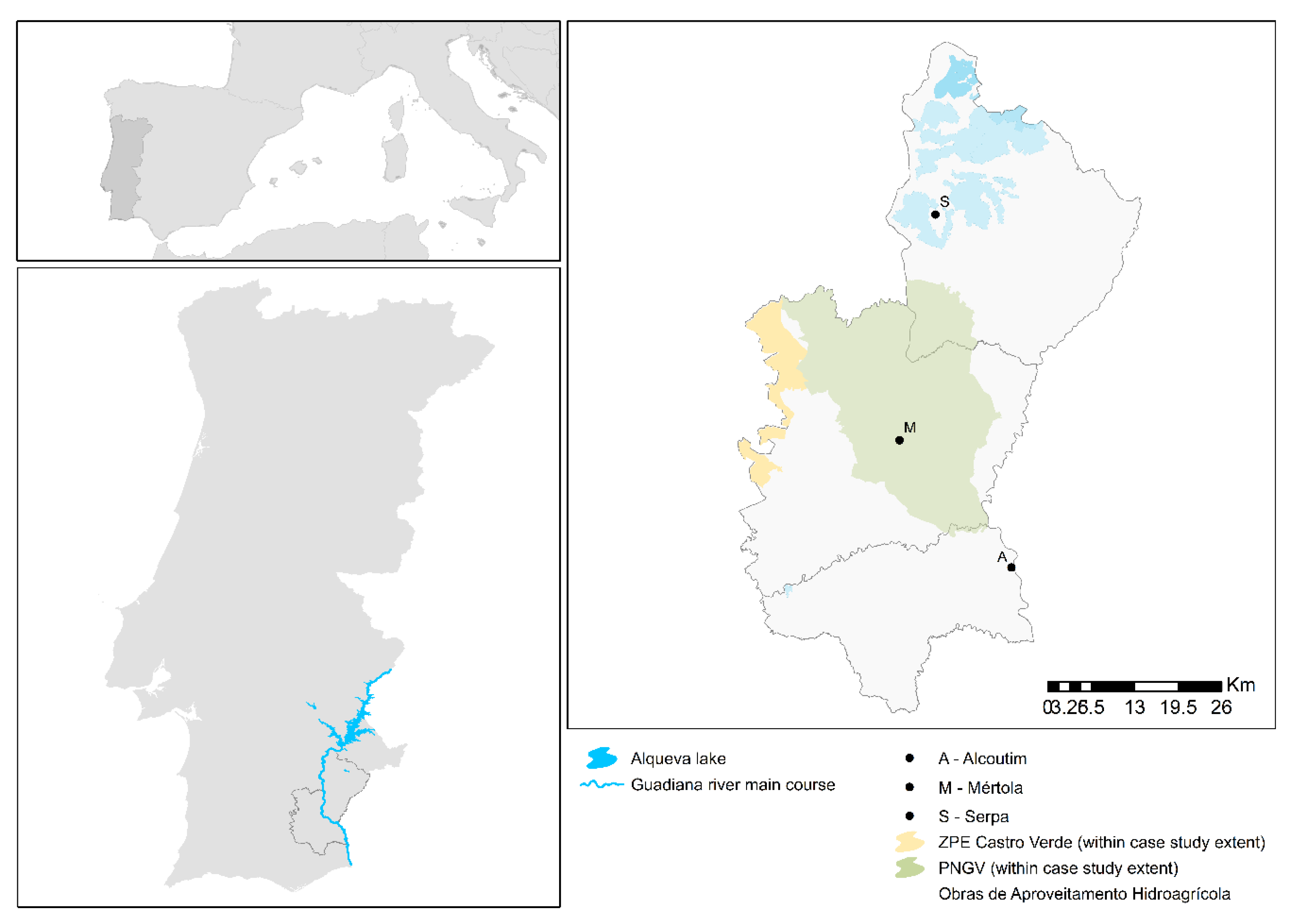
2. Case Study
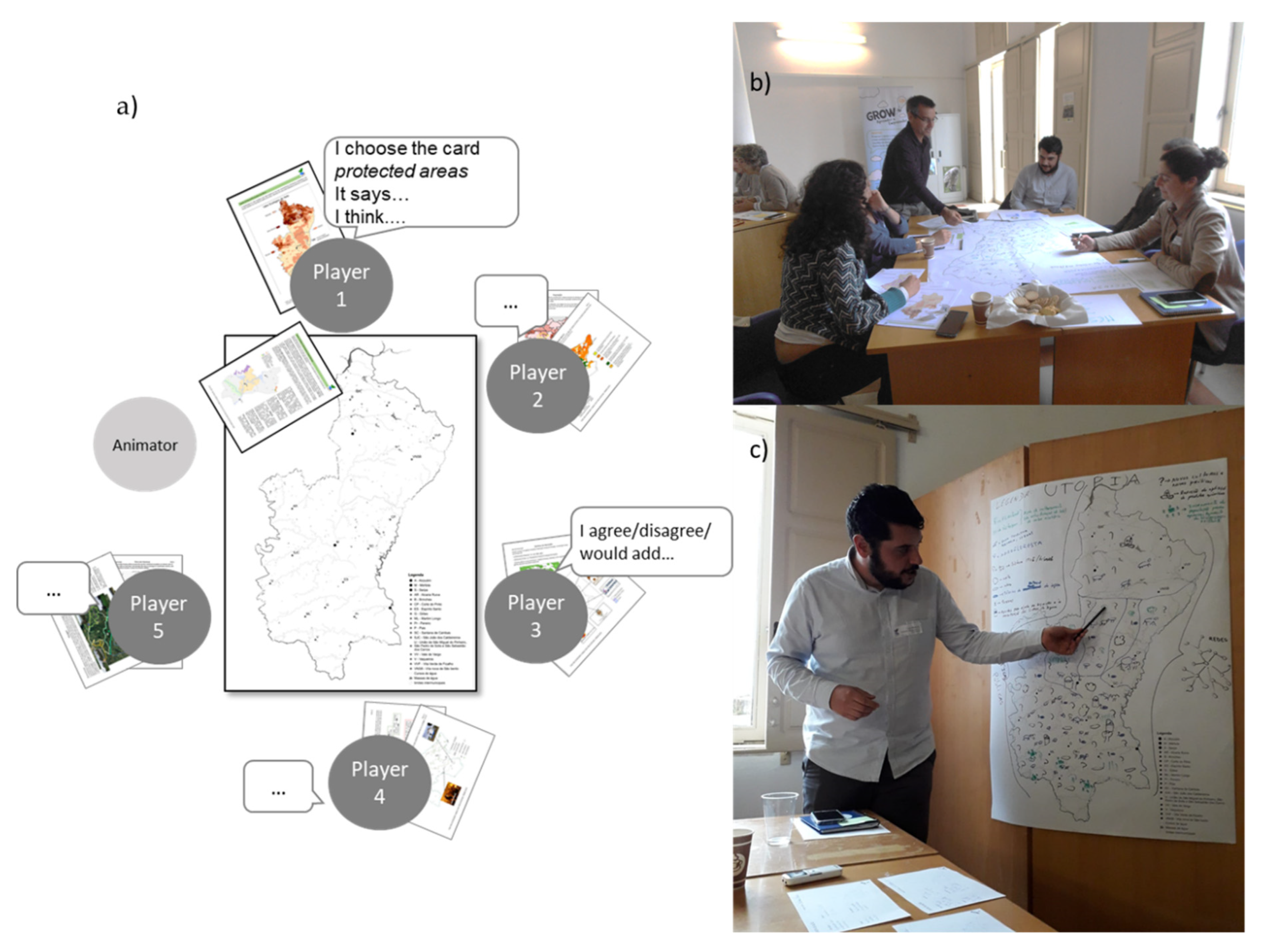
3. Methods
4. Results
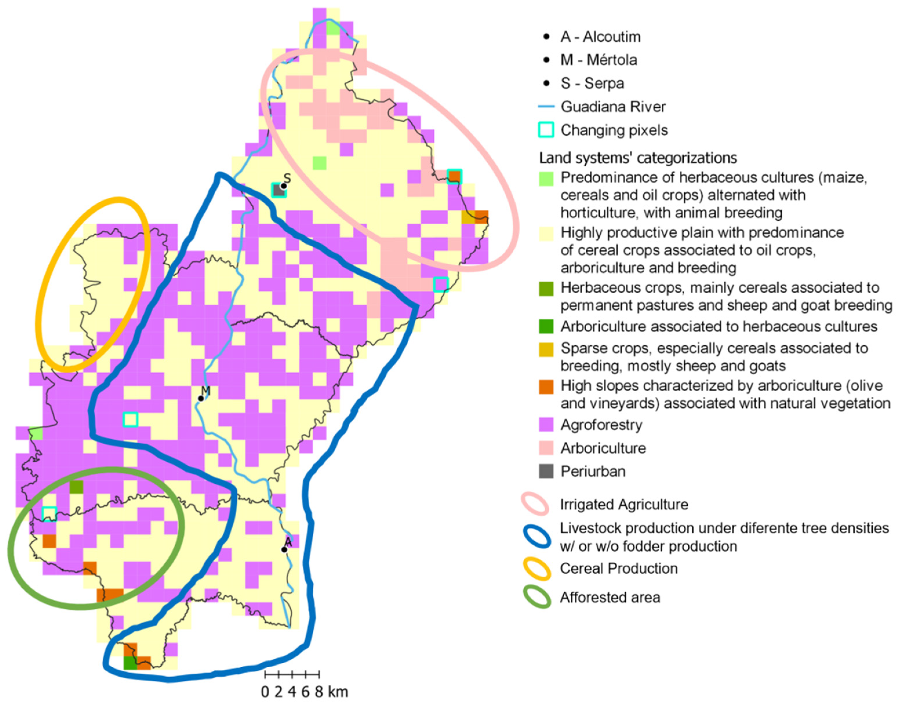
4.1. Establishing a Reference Point
4.2. Past and Present Dynamics
“People did not want to abandon the land, because it was family property, even if unproductive. Entering the European Union and agrarian policy made possible the forestation of the properties instead of them just being abandoned.”- Technician in forest association
“I am in favor of Alqueva but believe there should be limits to intensification. I was in favor of the Alqueva project, and of the possibility of agricultural diversification that did not exist.”– President Local Action Group operating in the study area
“Rainfed will not work in the future because of water scarcity. And if it will be scarce, we need to invest in water.”–Farmer in Alcoutim
4.3. (Un)Desired Future
“Agriculture must be irrigated. What is done in rainfed systems can only be valued by its services, like biodiversity.”–Technician at water management institution
“Rainfed production is not pretending agriculture. […] Irrigated agriculture cannot eliminate rainfed production.”– Extensive producer
5. Discussion
5.1. Dealing with Change
5.2. A Divergent Shared Vision
6. Conclusions
Author Contributions
Funding
Acknowledgments
Conflicts of Interest
References
- Peña, J.; Bonet, A.; Bellot, J.; Sánchez, J.R.; Eisenhuth, D.; Hallett, S.; Aledo, A. Driving Forces of Land-Use Change in a Cultural Landscape of Spain. In Modelling Land-Use Change; Springer: Dordrecht, The Netherlands, 2007; pp. 97–116. [Google Scholar]
- Turner, B.; Lambin, E.F.; Reenberg, A. The emergence of land change science for global environmental change and sustainability. Proc. Natl. Acad. Sci. USA 2007, 104, 20666–20671. [Google Scholar] [CrossRef] [PubMed]
- Nayak, P.K.; Berkes, F. Linking global drivers with local and regional change: A social-ecological system approach in Chilika Lagoon, Bay of Bengal. Reg. Environ. Chang. 2014, 14, 2067–2078. [Google Scholar] [CrossRef]
- Funatsu, B.M.; Dubreuil, V.; Racapé, A.; Debortoli, N.S.; Nasuti, S.; Le Tourneau, F.-M. Perceptions of climate and climate change by Amazonian communities. Glob. Environ. Chang. 2019, 57, 101923. [Google Scholar] [CrossRef]
- Pinto-Correia, T.; Kristensen, L. Linking research to practice: The landscape as the basis for integrating social and ecological perspectives of the rural. Landsc. Urban Plan. 2013, 120, 248–256. [Google Scholar] [CrossRef]
- Magliocca, N.R.; Rudel, T.K.; Verburg, P.H.; McConnell, W.J.; Mertz, O.; Gerstner, K.; Heinimann, A.; Ellis, E.C. Synthesis in land change science: Methodological patterns, challenges, and guidelines. Reg. Environ. Chang. 2015, 15, 211–226. [Google Scholar] [CrossRef] [PubMed]
- Blondel, J. The ‘Design’ of Mediterranean Landscapes: A Millennial Story of Humans and Ecological Systems during the Historic Period. Hum. Ecol. 2006, 34, 713–729. [Google Scholar] [CrossRef]
- Malek, Ž.; Verburg, P.H. Mediterranean land systems: Representing diversity and intensity of complex land systems in a dynamic region. Landsc. Urban Plan. 2017, 165, 102–116. [Google Scholar] [CrossRef]
- Pinto-Correia, T.; Mascarenhas, J. Contribution to the extensification/intensification debate: New trends in the Portuguese montado. Landsc. Urban Plan. 1999, 46, 125–131. [Google Scholar] [CrossRef]
- Debolini, M.; Marraccini, E.; Dubeuf, J.P.; Geijzendorffer, I.R.; Guerra, C.; Simon, M.; Targetti, S.; Napoléone, C. Land and farming system dynamics and their drivers in the Mediterranean Basin. Land Use Policy 2018, 75, 702–710. [Google Scholar] [CrossRef]
- Bugalho, M.N.; Caldeira, M.C.; Pereira, J.S.; Aronson, J.; Pausas, J.G. Mediterranean cork oak savannas require human use to sustain biodiversity and ecosystem services. Front. Ecol. Environ. 2011, 9, 278–286. [Google Scholar] [CrossRef]
- Nainggolan, D.; de Vente, J.; Boix-Fayos, C.; Termansen, M.; Hubacek, K.; Reed, M.S. Afforestation, agricultural abandonment and intensification: Competing trajectories in semi-arid Mediterranean agro-ecosystems. Agric. Ecosyst. Environ. 2012, 159, 90–104. [Google Scholar] [CrossRef]
- Magliocca, N.R.; Ellis, E.C.; Allington, G.R.H.; de Bremond, A.; Dell’Angelo, J.; Mertz, O.; Messerli, P.; Meyfroidt, P.; Seppelt, R.; Verburg, P.H. Closing global knowledge gaps: Producing generalized knowledge from case studies of social-ecological systems. Glob. Environ. Chang. 2018, 50, 1–14. [Google Scholar] [CrossRef]
- van Vliet, J.; de Groot, H.L.F.F.; Rietveld, P.; Verburg, P.H. Manifestations and underlying drivers of agricultural land use change in Europe. Landsc. Urban Plan. 2015, 133, 24–36. [Google Scholar] [CrossRef]
- Angeon, V.; Lardon, S. Participation and governance in territorial development projects: The “territory game” as a local project leadership system. Int. J. Sustain. Dev. 2008, 11, 262. [Google Scholar] [CrossRef]
- Muñoz-Rojas, J.; Pinto-Correia, T.; Napoleone, C. Farm and land system dynamics in the Mediterranean: Integrating different spatial-temporal scales and management approaches. Land Use Policy 2019, 88, 104082. [Google Scholar] [CrossRef]
- EDIA. Produção SERPA—Área e Culturas; EDIA - Empresa de Desenvolvimento e Infra-estruturas do Alqueva, S.A.: Beja, Portugal, 2018. [Google Scholar]
- DGADR Produtos Tradicionais Portugueses—DOP—Denominação de Origem Protegida. Available online: https://tradicional.dgadr.gov.pt/pt/produtos-por-regime-de-qualidade/dop-denominacao-de-origem-protegida (accessed on 4 October 2018).
- ICNF Parque Natural do Vale do Guadiana—ICNF. Available online: http://www2.icnf.pt/portal/ap/p-nat/pnvg (accessed on 4 October 2018).
- ICNF. Zonas de Protecção Especial: Castro Verde. Plano Sectorial da Rede Natura 2000. Available online: http://www2.icnf.pt/portal/pn/biodiversidade/rn2000/resource/doc/zpe-cont/zpe-c-verde (accessed on 4 October 2018).
- do Rosário, L. Indicadores de Desertificação Para Portugal Continental; Direcção, G., Núcleo de Desertificação: Lisbon, Portugal, 2004; ISBN 972-8797-55-7. [Google Scholar]
- Roxo, M.J.; Casimiro, P. MEDALUS Mediterranean desertification and land use. Estudos sobre desertificação no Baixo Alentejo Interior - Concelho de Mértola. GeoINova - Rev. do Dep. Geogr. e Planeam. Reg. 1999, 6–29. [Google Scholar]
- Leitão, M.; Cortez, N.; Pena, S.B. Valor Ecológico do Solo de Portugal Continental. LEAF/ISA/ULisboa EPIC WebGIS. 2013. Available online: http://epic-webgis-portugal.isa.utl.pt/ (accessed on 1 March 2019).
- Magalhães, M.R.; Müller, A.; Pena, S.B. Aptidão Edafo-morfológica à Agricultura de Regadio para Portugal Continental. LEAF/ISA/ULisboa EPIC WebGIS. 2015. Available online: http://epic-webgis-portugal.isa.utl.pt/ (accessed on 1 March 2019).
- INE. Population Census 2011—Employed Population (No.) by Place of Residence and Economic Activity (CAE Rev. 3). Available online: https://www.ine.pt/xportal/xmain?xpid=INE&xpgid=ine_indicadores&indOcorrCod=0008400&contexto=bd&selTab=tab2 (accessed on 4 October 2018).
- INE. Population Census 2011—Resident Population (No) by Place of Residence. Available online: https://www.ine.pt/xportal/xmain?xpid=INE&xpgid=ine_indicadores&indOcorrCod=0006044&contexto=bd&selTab=tab2 (accessed on 4 October 2018).
- INE. Agricultural Census 2009—Utilized Agricultural Area (UAA) by Geographic Location (NUTS-2013). Available online: https://www.ine.pt/xportal/xmain?xpid=INE&xpgid=ine_base_dados (accessed on 4 October 2018).
- SNIRH. Dados de Bases. Available online: http://snirh.pt/index.php?idMain=2&idItem=1 (accessed on 4 October 2018).
- Lardon, S. Developing a territorial project. The ‘territory game’, a coordination tool for local stakeholders. Res. Results FaçSADe 2013, 1–4. [Google Scholar]
- Bishop, I.D. Landscape planning is not a game: Should it be? Landsc. Urban Plan. 2011, 100, 390–392. [Google Scholar] [CrossRef]
- Ornetsmüller, C.; Castella, J.-C.; Verburg, P.H. A multiscale gaming approach to understand farmer’s decision making in the boom of maize cultivation in Laos. Ecol. Soc. 2018, 23, 35. [Google Scholar] [CrossRef]
- Reed, M.S.; Graves, A.; Dandy, N.; Posthumus, H.; Hubacek, K.; Morris, J.; Prell, C.; Quinn, C.H.; Stringer, L.C. Who’s in and why? A typology of stakeholder analysis methods for natural resource management. J. Environ. Manag. 2009, 90, 1933–1949. [Google Scholar] [CrossRef]
- Fusco, J.; Marraccini, E.; Debolini, M. Intensification, Periurbanization and Specialization of Agriculture as Significant Short-Term Land System Dynamics in the Mediterranean Basin. In Proceedings of the Colloque SAGEO 2019, Clermont-Ferrand, France, 13–15 november 2019; pp. 122–134. [Google Scholar]
- Fusco, J.; Villani, R.; Moulery, M.; Sabbatini, T.; Hinojosa-Valencia, L.; Napoleone, C.; Bondeau, A. DIVERCROP Project—Deliverable 1.1: Report on the Comprehensive Database Building. 2018. Available online: https://hal.archives-ouvertes.fr/hal-01907477 (accessed on 1 February 2020).
- Pinto Correia, T.; Lourenço, N.; Jorge, R.; Russo Machado, C. What is Happening in Rural Marginal Areas in Europe? Alcoutim, an Example in Southern Portugal; Manheimer Geogr. Arb. 1998. Available online: https://repositoriocientifico.uatlantica.pt/handle/10884/339 (accessed on 1 February 2020).
- Van Doorn, A.; Pinto-Correia, T. Differences in land cover interpretation in landscapes rich in cover gradients: Reflections based on the montado of South Portugal. Agrofor. Syst. 2007, 70, 169–183. [Google Scholar] [CrossRef]
- Fernández-Nogueira, D.; Corbelle-Rico, E. Determinants of Land Use/Cover Change in the Iberian Peninsula (1990–2012) at Municipal Level. Land 2019, 9, 5. [Google Scholar] [CrossRef]
- Caraveli, H. A comparative analysis on intensification and extensification in mediterranean agriculture: Dilemmas for LFAs policy. J. Rural Stud. 2000, 16, 231–242. [Google Scholar] [CrossRef]
- Casas, J.J.; Bonachela, S.; Moyano, F.J.; Fenoy, E.; Hernández, J. Agricultural Practices in the Mediterranean. In The Mediterranean Diet; Preedy, V.R., Watson, R.R., Eds.; Elsevier: Amsterdam, The Netherlands, 2015; pp. 23–36. ISBN 9780124078499. [Google Scholar]
- Neves, B.; Pires, I.M. The mediterranean diet and the increasing demand of the olive oil sector: Shifts and environmental consequences. Region 2018, 5, 101–112. [Google Scholar] [CrossRef]
- Palma, P.; Kuster, M.; Alvarenga, P.; Palma, V.L.; Fernandes, R.M.; Soares, A.M.V.M.; López de Alda, M.J.; Barceló, D.; Barbosa, I.R. Risk assessment of representative and priority pesticides, in surface water of the Alqueva reservoir (South of Portugal) using on-line solid phase extraction-liquid chromatography-tandem mass spectrometry. Environ. Int. 2009, 35, 545–551. [Google Scholar] [CrossRef]
- Ramos, T.B.; Darouich, H.; Šimůnek, J.; Gonçalves, M.C.; Martins, J.C. Soil salinization in very high-density olive orchards grown in southern Portugal: Current risks and possible trends. Agric. Water Manag. 2019, 217, 265–281. [Google Scholar] [CrossRef]
- Silveira, A.; Ferrão, J.; Muñoz-Rojas, J.; Pinto-Correia, T.; Guimarães, M.H.; Schmidt, L. The sustainability of agricultural intensification in the early 21st century:insights from the olive oil production in Alentejo (Southern Portugal). In Changing Societies: Legacies and Challenges. The Diverse Worlds of Sustainability; Delicado, A., Domingos, N., de Sousa, L., Eds.; Imprensa de Ciências Sociais: Lisbon, Portugal, 2018; pp. 247–275. ISBN 978-972-671-505-4. [Google Scholar]
- Despacho, n. Despacho n.o 3025/2017; Diário da República n.o 72/2017, Série II de 2017-04-11; Diário da República: Lisbon, Portugal, 2017; pp. 6862–6863. [Google Scholar]
- Valverde, P.; Serralheiro, R.; de Carvalho, M.; Shahidian, S.; Rodrigues, C. Efeitos das alterações climáticas nas necessidades úteis de rega na bacia do Guadiana. Rev. Recur. Hídricos 2014, 35, 53–67. [Google Scholar] [CrossRef][Green Version]
- Costa, A.; Madeira, M.; Lima Santos, J.; Oliveira, A.; Oliveira, Â. Change and dynamics in Mediterranean evergreen oak woodlands landscapes of Southwestern Iberian Peninsula. Landsc. Urban Plan. 2011, 102, 164–176. [Google Scholar] [CrossRef]
- PROF do Alentejo - Portaria 54/2019; Diário da República n.o 29/2019, Série I de 2019-02-11; Diário da República: Lisbon, Portugal, 2019; pp. 1060–1079.
- García-Tejero, I.F.; Durán-Zuazo, V.H.; Muriel-Fernández, J.L. Towards sustainable irrigated Mediterranean agriculture: Implications for water conservation in semi-arid environments. Water Int. 2014, 39, 635–648. [Google Scholar] [CrossRef]
- Rodríguez-Ortega, T.; Bernués, A.; Olaizola, A.M.; Brown, M.T. Does intensification result in higher efficiency and sustainability? An emergy analysis of Mediterranean sheep-crop farming systems. J. Clean. Prod. 2017, 144, 171–179. [Google Scholar] [CrossRef]
- Iglesias, A.; Garrote, L.; Flores, F.; Moneo, M. Challenges to Manage the Risk of Water Scarcity and Climate Change in the Mediterranean. Water Resour. Manag. 2007, 21, 775–788. [Google Scholar] [CrossRef]
- Almeida, M.; Azeda, C.; Guiomar, N.; Pinto-Correia, T. The effects of grazing management in montado fragmentation and heterogeneity. Agrofor. Syst. 2016, 90, 69–85. [Google Scholar] [CrossRef]
- Pinto-Correia, T.; Azeda, C. Public policies creating tensions in Montado management models: Insights from farmers’ representations. Land Use Policy 2017, 64, 76–82. [Google Scholar] [CrossRef][Green Version]
- Geels, F.W. Processes and patterns in transitions and system innovations: Refining the co-evolutionary multi-level perspective. Technol. Forecast. Soc. Chang. 2005, 72, 681–696. [Google Scholar] [CrossRef]
- Pe’er, G.; Bonn, A.; Bruelheide, H.; Dieker, P.; Eisenhauer, N.; Feindt, P.H.; Hagedorn, G.; Hansjürgens, B.; Herzon, I.; Lomba, A.; et al. Action needed for the EU Common Agricultural Policy to address sustainability challenges. People Nat. 2019, 1–10. [Google Scholar] [CrossRef]
- Morais, L.F. Contributos da valorização do património arqueológico para o desenvolvimento local. In Proceedings of the Actas do XII Colóquio Ibérico de Geografia, Porto, Portugal, 6–10 October 2010. [Google Scholar]
- Madureira, L.; Lima Santos, J.; Ferreira, A.; Guimarães, H. Feasibility Study on the Valuation of Public Goods and Externalities in EU Agriculture; Publications Office of the European Union: Luxembourg, 2013. [Google Scholar]
- Guerra, C.A.; Pinto-Correia, T. Linking farm management and ecosystem service provision: Challenges and opportunities for soil erosion prevention in Mediterranean silvo-pastoral systems. Land Use Policy 2016, 51, 54–65. [Google Scholar] [CrossRef]
- Lima Santos, J.; Madureira, L.; Ferreira, A.C.; Espinosa, M.; Gomez y Paloma, S. Mapping and Valuing Multiple Ecosystems Services at the Macro-Regional Scale. Presented at the Seminar PNOT “Território e Serviços dos Ecossistemas”, Lisbon, Portugal, February 2017. Available online: https://www.google.com/url?sa=t&rct=j&q=&esrc=s&source=web&cd=1&cad=rja&uact=8&ved=2ahUKEwj_ioG12Z_oAhXn1uAKHVARCXgQFjAAegQIAhAB&url=http%3A%2F%2Fwww.dgterritorio.pt%2Ffiledownload.aspx%3Fschema%3Db511271f-54fe-4d21-9657-24580e9b7023%26channel%3D5D83BE99-238C-4727-83D4-712E7C3188A0%26content_id%3D24556535-A1BA-4D68-817D-32B0FF46F1D0%26field%3Dfile%26lang%3Dpt%26ver%3D1%26filetype%3Dpdf%26dtestate%3D2017-04-07143000&usg=AOvVaw0mew5lfelviLnEMfJtnzBh (accessed on 1 February 2020).
- Burton, R.J.F.; Schwarz, G. Result-oriented agri-environmental schemes in Europe and their potential for promoting behavioural change. Land Use Policy 2013, 30, 628–641. [Google Scholar] [CrossRef]
- Costa, A.C.; Santos, J.A.; Pinto, J.G. Climate change scenarios for precipitation extremes in Portugal. Theor. Appl. Climatol. 2012, 108, 217–234. [Google Scholar] [CrossRef]
- Fader, M.; von Bloh, W.; Shi, S.; Bondeau, A.; Cramer, W. Modelling Mediterranean agro-ecosystems by including agricultural trees in the LPJmL model. Geosci. Model Dev. 2015, 8, 3545–3561. [Google Scholar] [CrossRef]
- Döll, P.; Fiedler, K.; Zhang, J. Global-scale analysis of river flow alterations due to water withdrawals and reservoirs. Hydrol. Earth Syst. Sci. 2009, 13, 2413–2432. [Google Scholar] [CrossRef]
- Gómez Gómez, C.M.; Pérez Blanco, C.D. Do drought management plans reduce drought risk? A risk assessment model for a Mediterranean river basin. Ecol. Econ. 2012, 76, 42–48. [Google Scholar] [CrossRef]
- Valverde, P.; de Carvalho, M.; Serralheiro, R.; Maia, R.; Ramos, V.; Oliveira, B. Climate change impacts on rainfed agriculture in the Guadiana river basin (Portugal). Agric. Water Manag. 2015, 150, 35–45. [Google Scholar] [CrossRef]
- Laraus, J. The problems of sustainable water use in the Mediterranean and research requirements for agriculture. Ann. Appl. Biol. 2004, 144, 259–272. [Google Scholar] [CrossRef]
- Kassam, A.; Friedrich, T.; Derpsch, R.; Lahmar, R.; Mrabet, R.; Basch, G.; González-Sánchez, E.J.; Serraj, R. Conservation agriculture in the dry Mediterranean climate. Field Crop. Res. 2012, 132, 7–17. [Google Scholar] [CrossRef]
- Pinto-Correia, T.; Ribeiro, N.; Sá-Sousa, P. Introducing the montado, the cork and holm oak agroforestry system of Southern Portugal. Agrofor. Syst. 2011, 82, 99–104. [Google Scholar] [CrossRef]


| Serpa | Mértola | Alcoutim | |
|---|---|---|---|
| Area (ha) | 110,563 | 129,287 | 57,536 |
| Population density a (nº/km2) | 14.1 | 5.6 | 5.1 |
| UAA b (ha) | 86,546 | 90,018 | 12,448 |
| 3-year average irrigated area c (ha) | 8,244 | 649 | 52 |
| Annual rainfall a (mm) | 314.4 | 366.2 | 347.1 |
| Number of Territorial Actors | Sectors That Territorial Actors Represent | |
|---|---|---|
| Interviews | 22 | Local public administration (municipality level, 4), local farmers and farmer’s organizations (6), local associations and NGOs (7), regional public administration (4), irrigation enterprise (1) |
| Territory Game | 23 | Local public administration (municipality level, 3), local farmers and farmer’s organizations (4), local associations and NGOs (10), regional public administration (3), senior researcher on agricultural science (1), Guadiana Valley Natural Park (PNVG) management (2) |
| Issue | Desirable Future | Suggested Actions |
|---|---|---|
| Maintenance, protection and improvement of land systems | Improved soil Policies and measures fitted to extensive, multifunctional systems (of Montado in particular) Increased tree cover The predominance of multifunctional systems Silvopastoral practices compatible with values and rules of PNVG Natural park | Change common agricultural policy (CAP) schemes and values not to favor ill-adjusted or unsustainable practices Integration of “forest” and “agricultural” policy measures considering the existence of agroforestry systems Empowerment of farmers, landowners and policymakers on good practices, adaptive management, water and soil conservation techniques through field trips and knowledge transference |
| Increase water availability | Water seeding—agricultural practices concerned with water conservation such as swales and ponds. Use of irrigation as a complement to rainfed systems Accessible irrigation infrastructures to a wider population | Empowerment of farmers, landowners and policymakers on good practices, adaptive management, water collection and conservation techniques through field trips and knowledge transference |
| Cooperation between actors | More dialogue amongst different entities Find and converge on common points of concern | Creation of lobby group to represent the interest of the territory near decision-makers |
| Population | Maintain and increase the rural population | Incentives for business opportunities and job creation in the territory |
| Local market | Ease of access to local products in the local market and increase awareness of buyers for local consumption | Relax public procurement regulations to facilitate placement of local products in the local market (including public canteens and restaurants) Increase awareness of local buyers for local consumption |
| Transformation and commercialization strategies | Organized producers to gain commercialization strength Multifunctional processing center in the territory Access to niche markets The Guadiana River as a “road” to reach a wider market | Collective transformation facilities, including a collective kitchen and multipurpose factory Creation of a platform of commercialization of the products from the territory |
| Energetic production | Investment in small projects across the territory |
© 2020 by the authors. Licensee MDPI, Basel, Switzerland. This article is an open access article distributed under the terms and conditions of the Creative Commons Attribution (CC BY) license (http://creativecommons.org/licenses/by/4.0/).
Share and Cite
Esgalhado, C.; Guimaraes, M.H. Unveiling Contrasting Preferred Trajectories of Local Development in Southeast Portugal. Land 2020, 9, 87. https://doi.org/10.3390/land9030087
Esgalhado C, Guimaraes MH. Unveiling Contrasting Preferred Trajectories of Local Development in Southeast Portugal. Land. 2020; 9(3):87. https://doi.org/10.3390/land9030087
Chicago/Turabian StyleEsgalhado, Catarina, and Maria Helena Guimaraes. 2020. "Unveiling Contrasting Preferred Trajectories of Local Development in Southeast Portugal" Land 9, no. 3: 87. https://doi.org/10.3390/land9030087
APA StyleEsgalhado, C., & Guimaraes, M. H. (2020). Unveiling Contrasting Preferred Trajectories of Local Development in Southeast Portugal. Land, 9(3), 87. https://doi.org/10.3390/land9030087