Detecting Land Abandonment in Łódź Voivodeship Using Convolutional Neural Networks

 , , , and
Abstract

1. Introduction
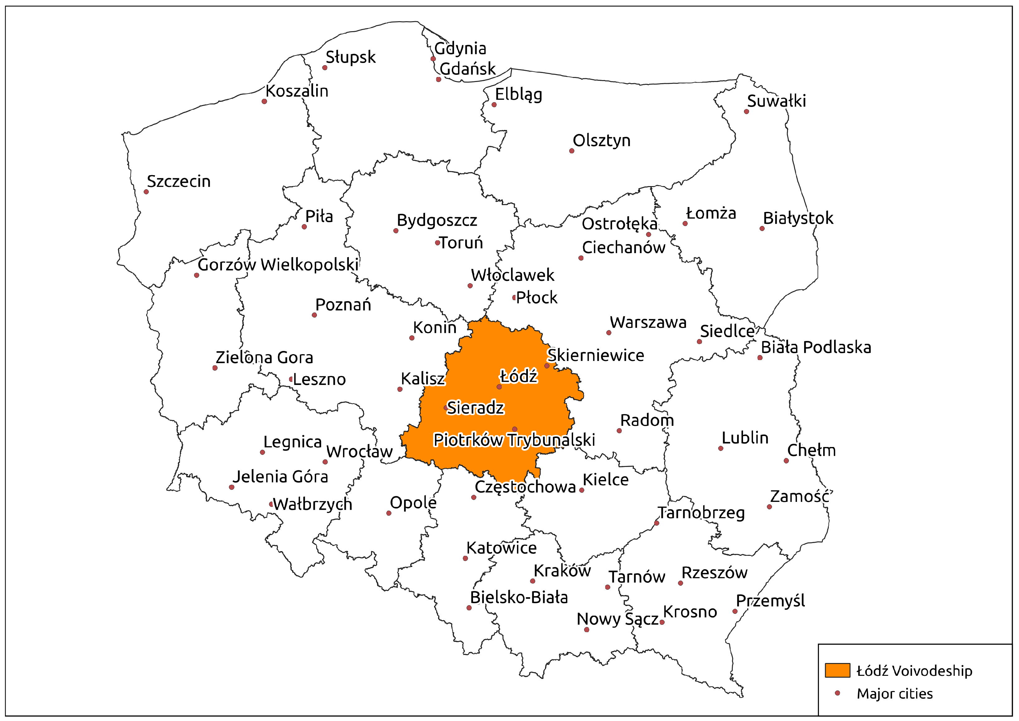
2. Materials and Methods
2.1. Background
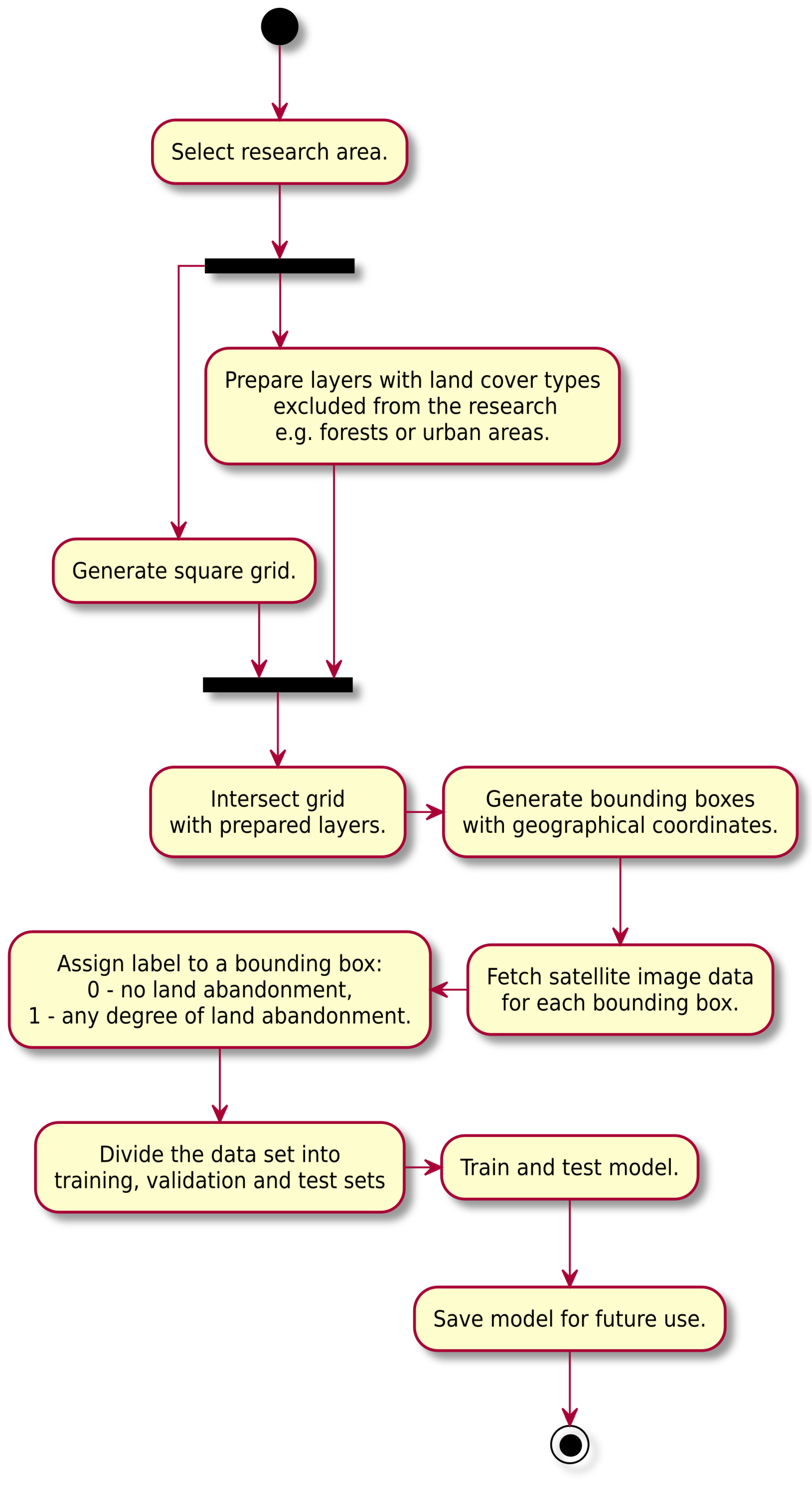
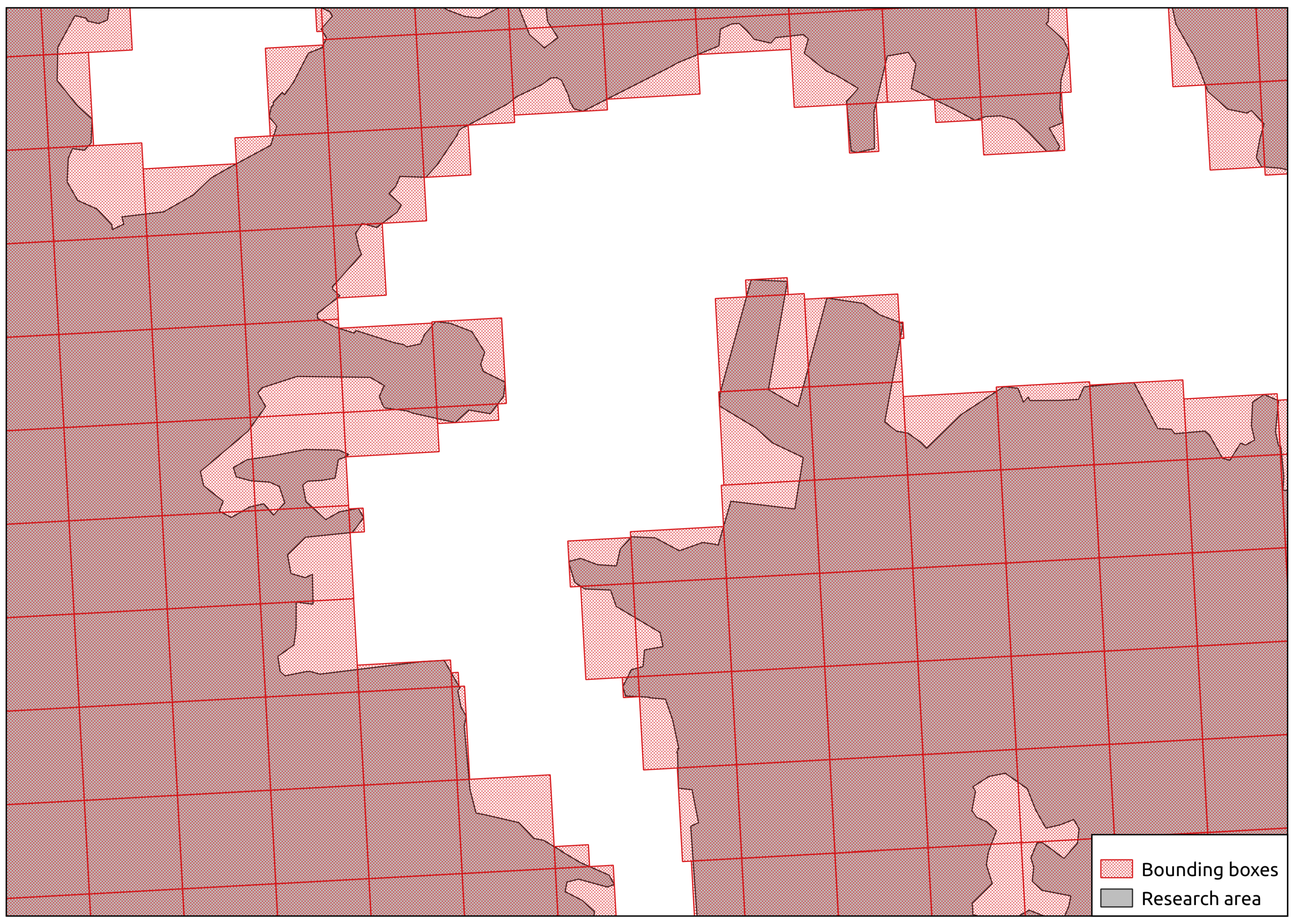
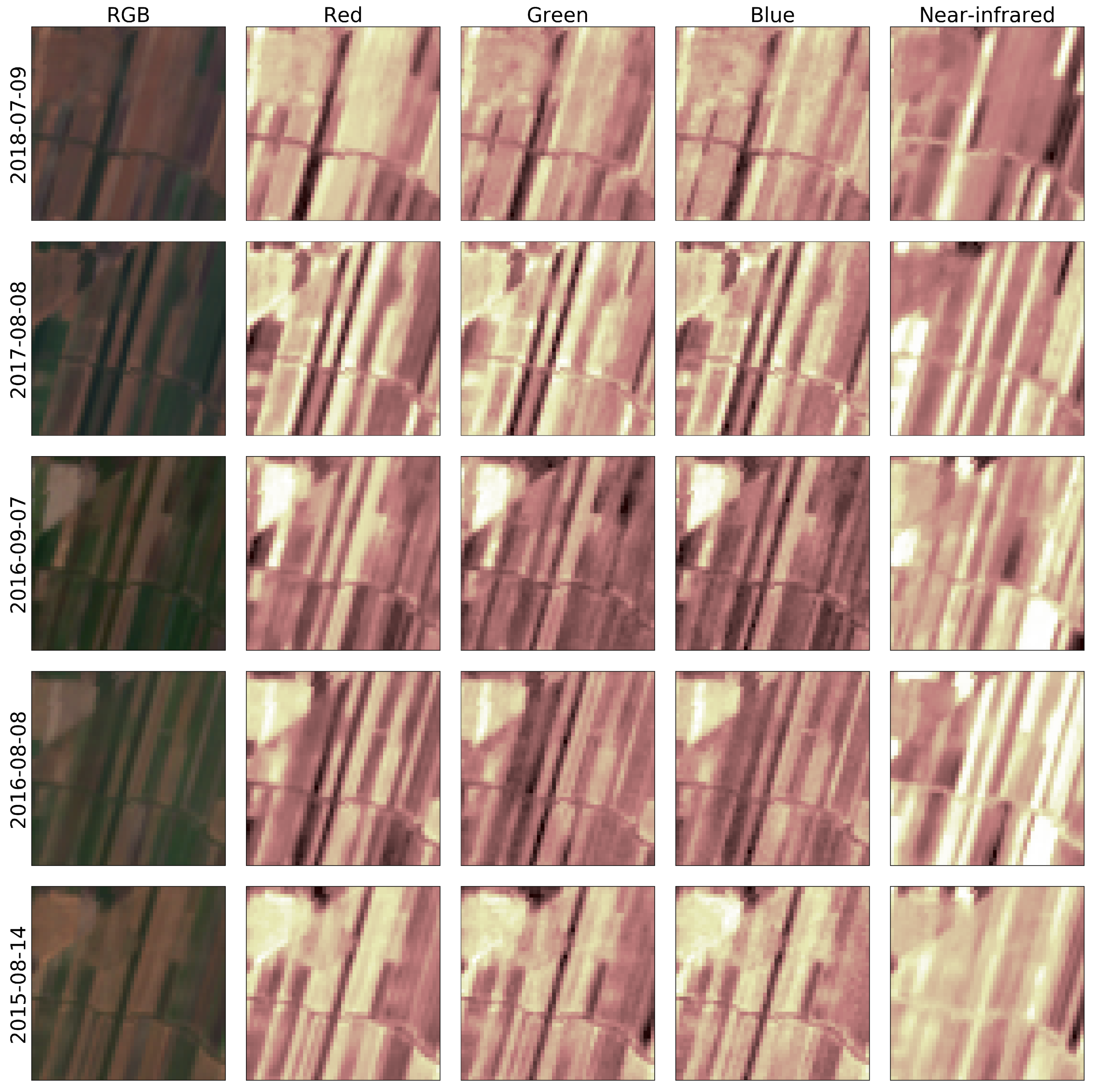
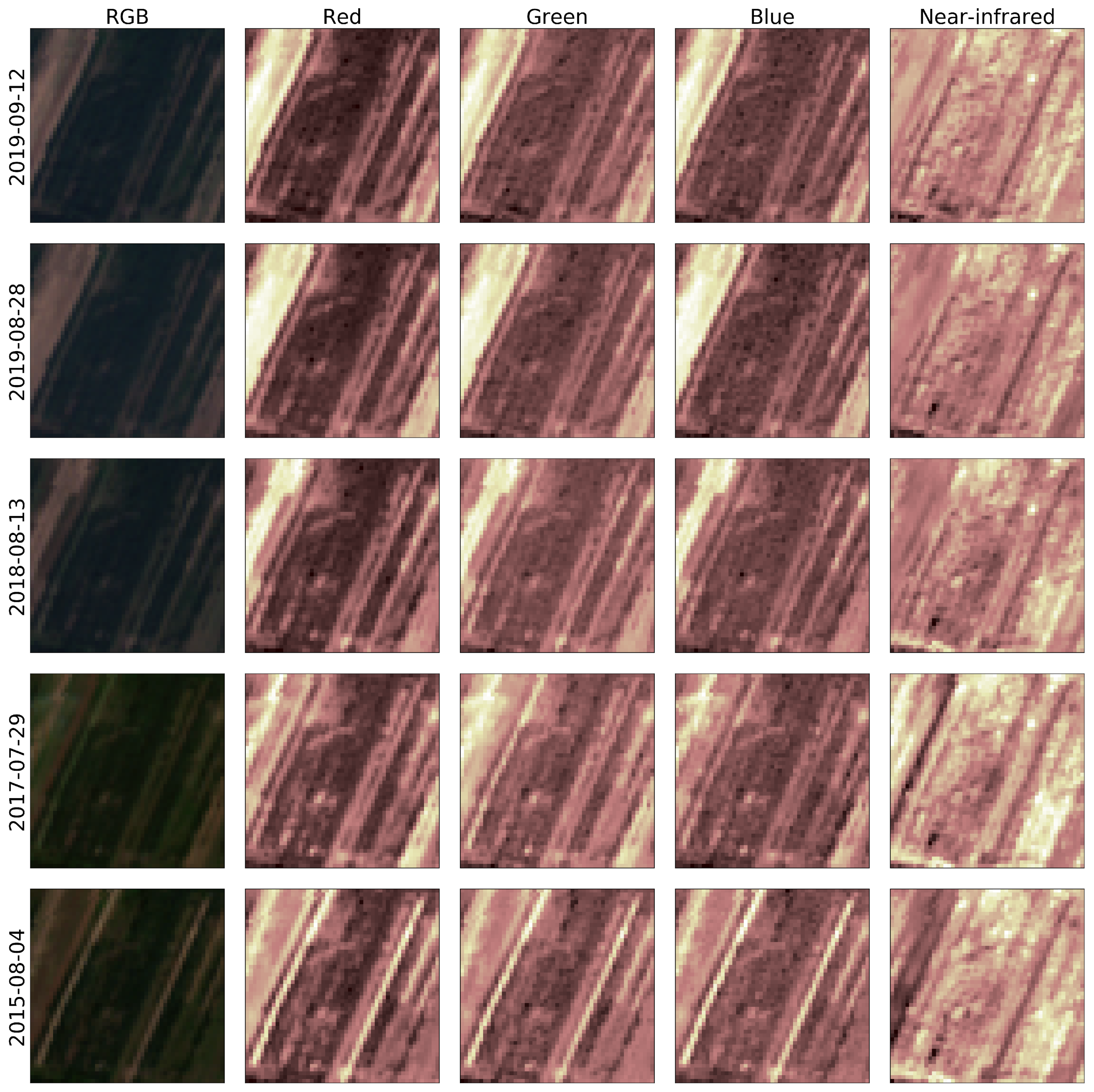
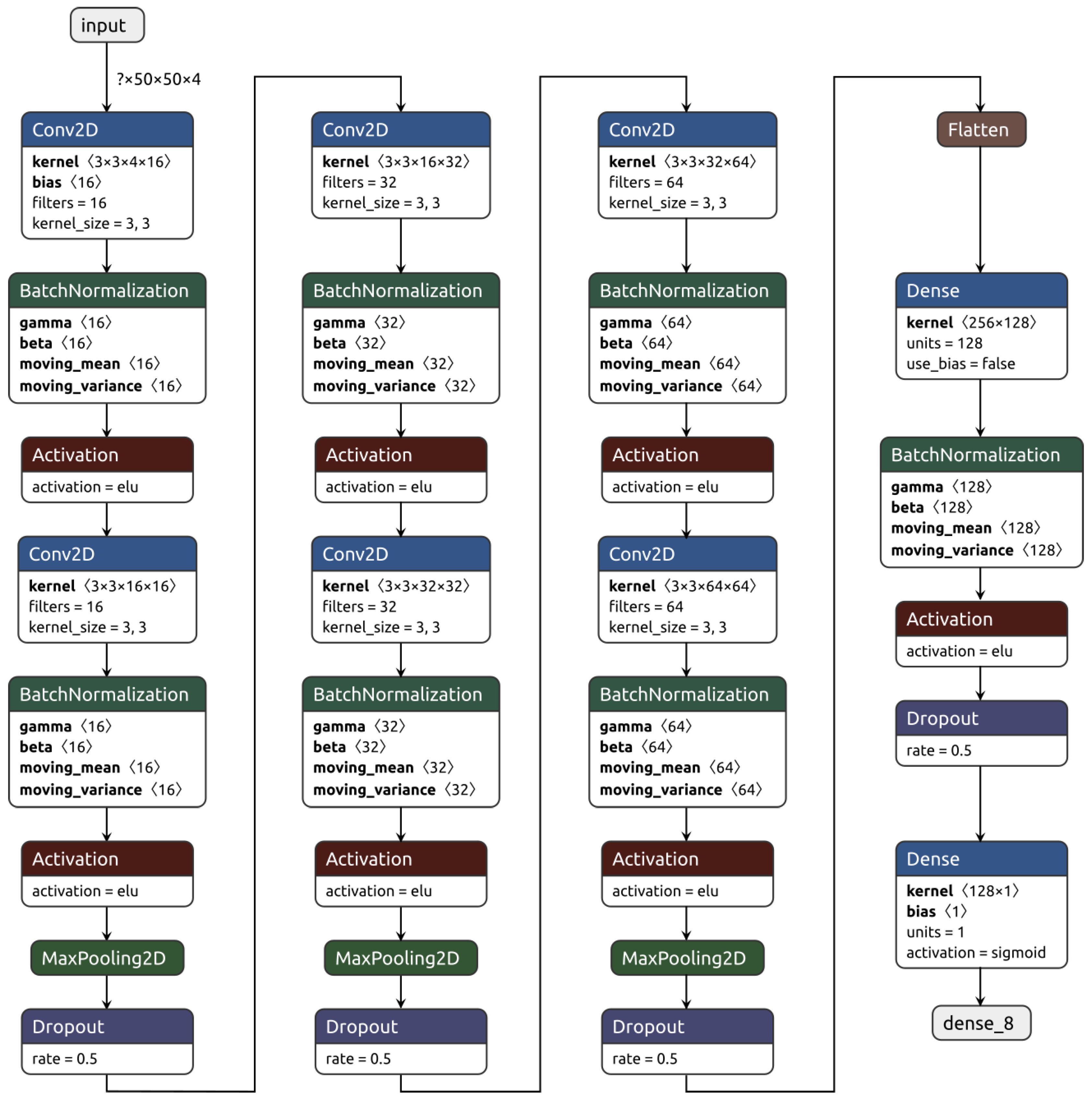
2.2. Data and Model Preparation
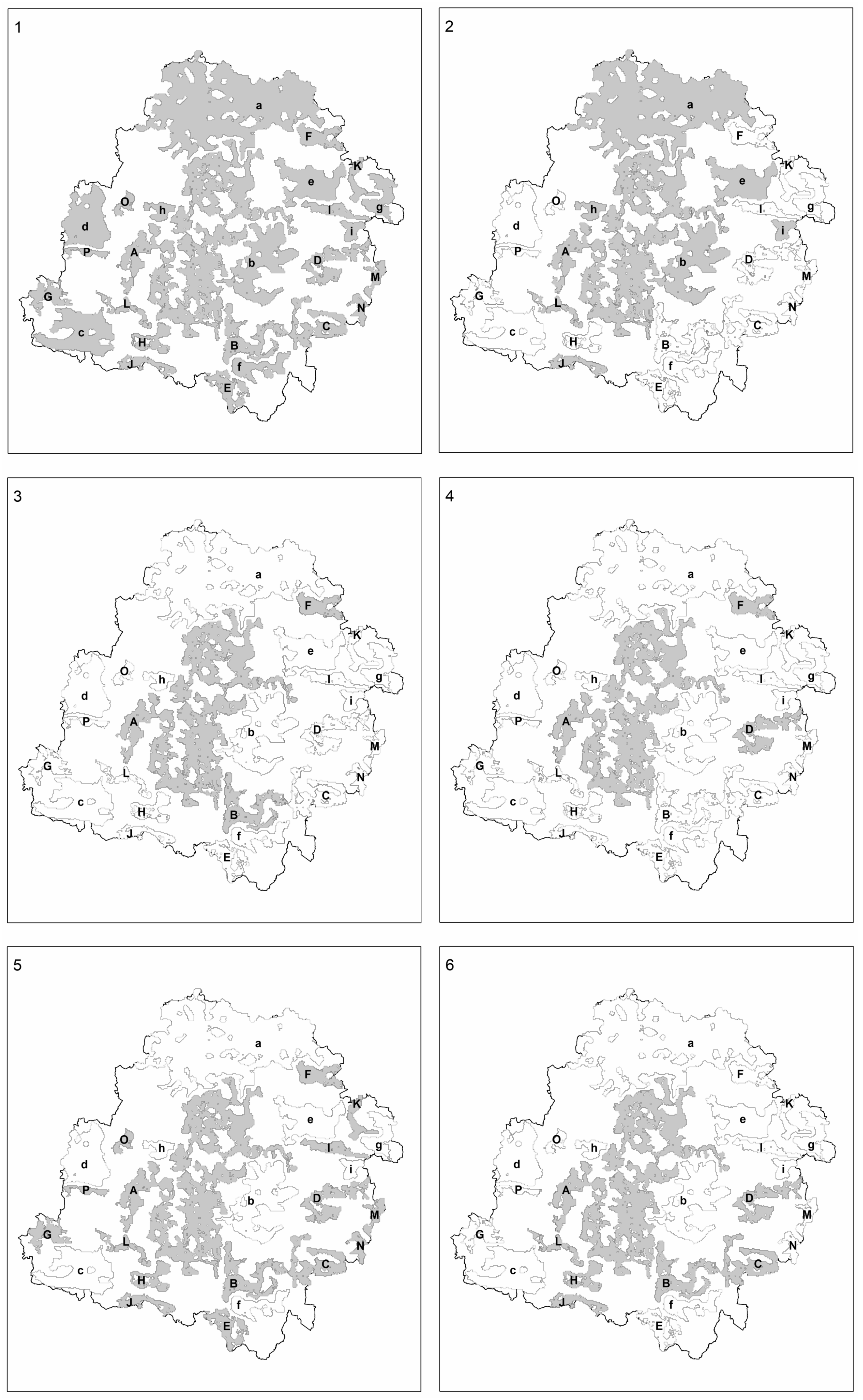
3. Results
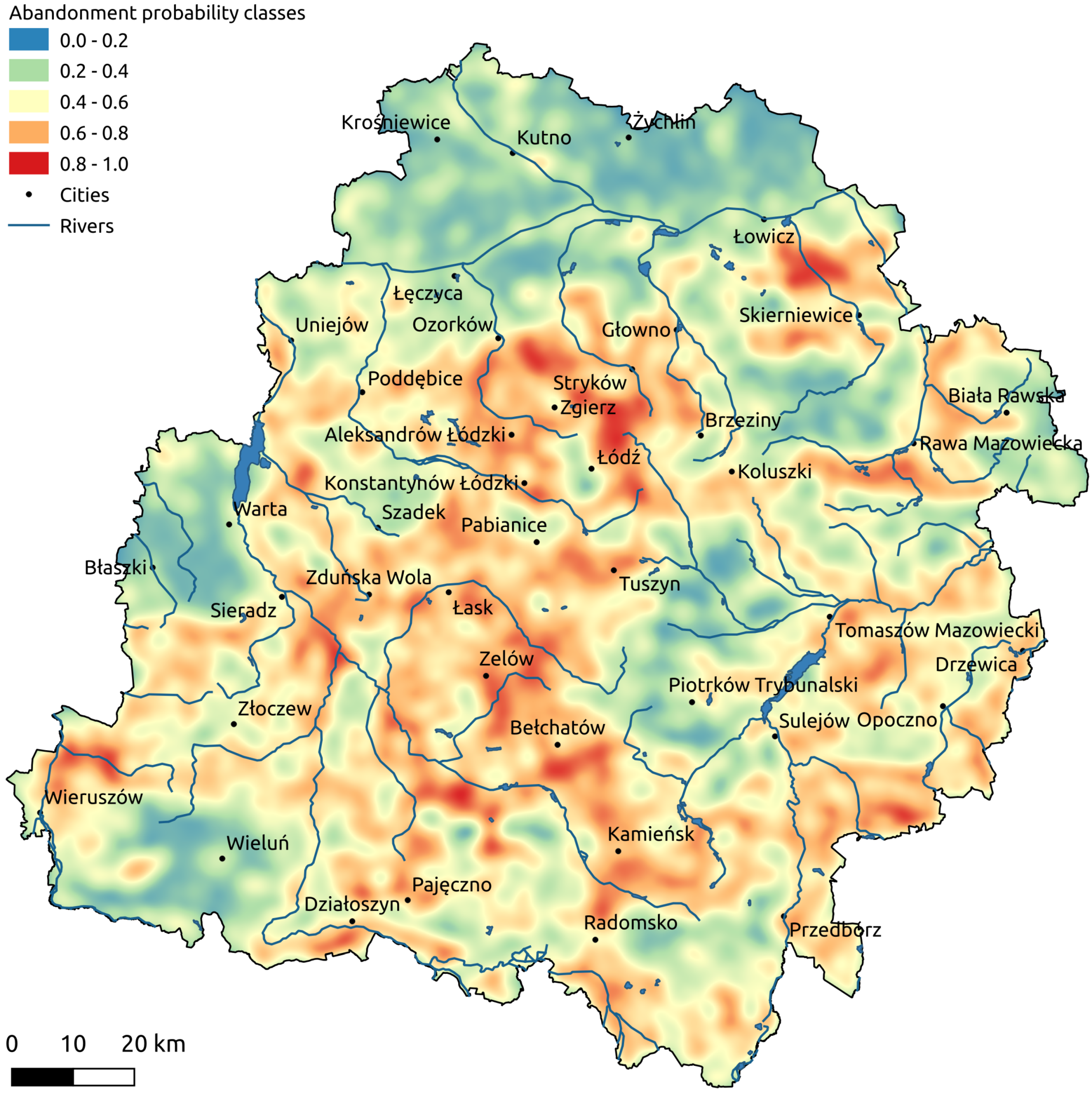
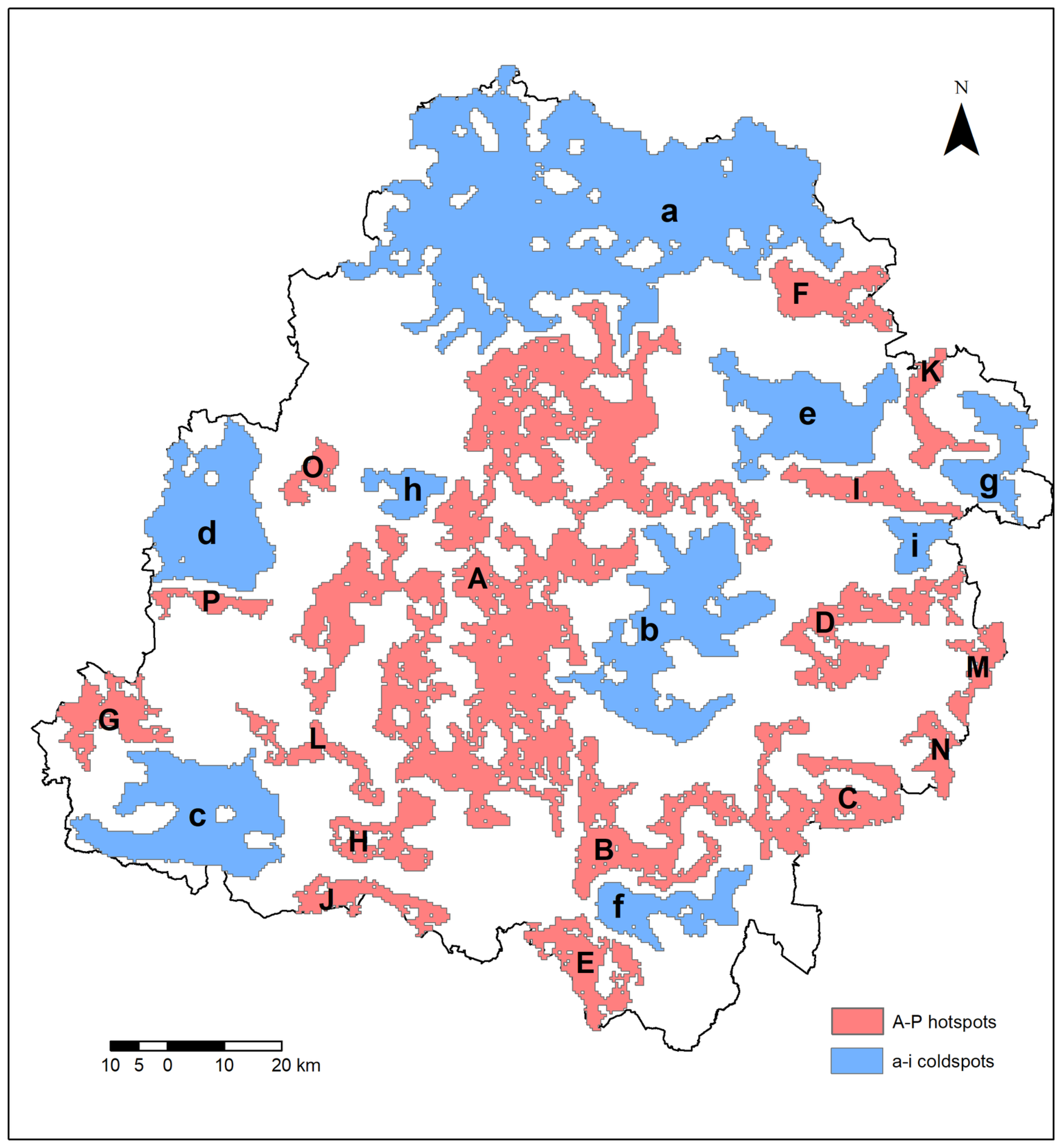
- The presence of soil complexes assigned to the highest classes of arability (1,2,3,4,8) [52], applicable to all coldspots, i.e., (a–i);
- The presence of soils with a high proportion of silt, a characteristic that affects their air-and-moisture-related properties, improves vegetation access to groundwater, and simultaneously retards rain-and meltwater infiltration. This feature is dominant in the following coldspots: (b), (c), (d), (e), (f), (g), and (i);
- The presence of soils developed from till or clayey sand underlain by till. This occurs in all coldspots other than (f);
- The presence of a relatively homogeneous landscape, dominated by plains and thus beneficial to agriculture. Coldspot (a) provides the starkest example with level terrain and a dominant, slightly southern slope, facilitating drainage of excessive melt- and rainwater towards the Bzura river valley. Plains also characterize the following coldspots: (b), (e), (h), and (i).
- Low-quality soil, usually of those qualified as (6), (7), (9) among arability complexes, as well as (very) poor meadowland and pastures “3z” [52]. The aforementioned complexes are common within all identified hotspots;
- A significant presence of forest complexes, especially in the form of numerous sparse patches. A characteristic of abandoned land distribution is a higher occurrence on the peripheries of cultivated fields neighboring forests. This property is intrinsic to all identified hotspots;
- The vicinity of expressways, motorways, and the associated interchanges. Present in hotspots (A), (B), and (F);
- The presence of urbanization and suburbanization near major cities, e.g., Łódź and Zgierz for hotspot (A), as well as in hotspots (D) and (F);
- The vicinity of sand, gravel, sandstone, and limestone extraction sites, as well as the presence of poor-quality soils bordering lignite strip mines. This exploitation of natural resources influences the scale of land abandonment in hotspots (A), (B), (C), (D), (H), (J), and (L);
- The presence of forests and zones along riversides and around the shorelines of lakes and reservoirs, where natural assets have contributed to the development of vacation settlements. Recreational land use among abandoned lands is characteristic of hotspots (A), (B), (C), (D), (L), (O);
- Undulating terrain, with an increased occurrence of hills to the point of hindering fieldwork and facilitating excessive drainage. This relationship arises in hotspots located in the southern portion of the Łódź Voivodeship, such as (L) and (J), and in the relevant part of the (A) hotspot;
- Overgrowth of disused meadows and pastures located in river valleys. Present in all relevant areas but especially prominent in the following hotspots: (A), (B), (C), (D), (E), (J);
- Frontier and periphery locations combined with low economic feasibility, apparent within the southeastern and southern borderlands of the voivodeship. These conditions are relevant to the following hotspots: (C), (E), (J), (M), (N).
4. Discussion
5. Conclusions and Future Work Opportunities
Supplementary Materials
Author Contributions
Funding
Acknowledgments
Conflicts of Interest
References
- Borowska-Stefańska, M.; Leśniewska-Napierała, K.; Wiśniewski, S. Land cover changes in Poland between 1990 and 2012. Geografie 2018, 123, 63–89. [Google Scholar] [CrossRef][Green Version]
- Janus, J.; Bożek, P. Land abandonment in Poland after the collapse of socialism: Over a quarter of a century of increasing tree cover on agricultural land. Ecol. Eng. 2019, 138, 106–117. [Google Scholar] [CrossRef]
- Krysiak, S. Współczesne tendencje zmian w użytkowaniu nadpilicznych krajobrazów rolniczych na tle potencjału siedliskowego geokompleksów. Probl. Ekol. Kraj. 2006, XV, 228–241. [Google Scholar]
- Bański, J. Gospodarka Ziemią w Polsce w Okresie Restrukturyzacji; IGiPZ PAN: Warszawa, Poland, 1998; pp. 1–117. [Google Scholar]
- Bański, J. Geografia Polskiej Wsi; PWE: Warszawa, Poland, 2006; pp. 1–218. [Google Scholar]
- Kucharski, L. Przemiany roślinności łąkowej w Polsce Środkowej w wyniku zmian metod gospodarowania. In Problemy Ochrony I UżYtkowania ObszaróW Wiejskich O DużYch Walorach Przyrodniczych; Wydawnictwa Uniwersytetu Marii Skłodowskiej-Curie: Lublin, Poland, 2000; pp. 227–234. [Google Scholar]
- Orłowski, G.; Nowak, L. Problematyka odłogowania gruntów w świetle wyników badań prowadzonych w krajach Europy Zachodniej i Stanach Zjednoczonych. (Artykuł przeglądowy). Acta Sci. Pol. Agric. 2004, 3, 27–36. [Google Scholar]
- Statistics Poland. Land use. In Rural Areas in Poland—National Agricultural Census 2010; Statistics Poland: Warszawa, Poland, 2013; pp. 1–87. [Google Scholar]
- Rozporządzenie Ministra Rozwoju Regionalnego i Budownictwa z dnia 29 Marca 2001 r. w Sprawie Ewidencji Gruntów i Budynków (Dz. U. rok 2001, nr 38, poz. 454); Chancellery of the Prime Minister of Poland: Warsaw, Poland, 2001.
- Krysiak, S. Odłogi w krajobrazach Polski środkowej-aspekty przestrzenne, typologiczne i ekologiczne. Probl. Ekol. Kraj. 2011, XXXI, 89–96. [Google Scholar]
- Czesak, B.; Cegielska, K.; Cherkes, B.; Różycka-Czas, R.; Salata, T. Fieldwork approach to determining the extent of agricultural land abandonment—Case study. Geomat. Landmanag. Landsc. 2016, 3, 21–31. [Google Scholar] [CrossRef]
- Krysiak, S. Struktura użytkowania ziemi w dorzeczu Dzierżąznej–charakterystyka i aspekty hydrologiczne zagospodarowania zlewni. Folia Geogr. Phys. 2000, 5, 83–92. [Google Scholar]
- Matuszyńska, J. Zmiany użytkowania terenu jako element transformacji środowiska przyrodniczego na obszarze wybranych zlewni Poznania i jego strefy podmiejskiej. In Prace Komisji Geograficzno-Geologicznej; PTPN: Poznań, Poland, 2001; Volume 30, pp. 1–160. [Google Scholar]
- Krysiak, S. Contemporary land-use changes in Central Poland. Pap. Glob. Chang. IGBP 2008, 15, 89–103. [Google Scholar]
- Krysiak, S. Ekologiczne aspekty przemian użytkowania ziemi w wybranych typach krajobrazów naturalnych Polski Środkowej. Probl. Ekol. Kraj. 2008, XXI, 299–310. [Google Scholar]
- Krysiak, S. Ekologiczno-krajobrazowy wymiar odłogowanych gruntów porolnych—przykłady z województwa łódzkiego. In Obszary Metropolitalne We Współczesnym środowisku Geograficznym; Oddział Łódzki PTG-Wydział Nauk Geograficznych Uniwersytetu Łódzkiego: Łódź, Poland, 2010; pp. 309–320. [Google Scholar]
- Jermaczek, D. Analiza rozmieszczenia i struktury zadrzewien powstalych na odlogowanych gruntach porolnych w okolicach Lagowa w latach 1990–2007. PrzegląD Przyr. 2007, XVIII, 29–53. [Google Scholar]
- Krysiak, S.; Papińska, E.; Majchrowska, A. Abandoned agricultural lands in buffer zones around landscape parks in the Łódź Voivodeship—habitat background, spatial distribution, scale of the phenomenon. In The Ecological Role of Abandoned Agricultural Lands in Buffer Zones Around Landscape Parks in the Łódź Voivodeship; Krysiak, S., Adamczyk, J., Eds.; Wydawnictwo Uniwersytetu Łódzkiego: Łódź, Poland, 2016. [Google Scholar] [CrossRef]
- Majchrowska, A. Abandonment of agricultural land in central Poland and its ecological role. Ekológia 2013, 32, 320–327. [Google Scholar] [CrossRef][Green Version]
- Majchrowska, A. Odłogowanie gruntów w otoczeniu parków krajobrazowych. In Studia Obszarów Wiejskich; IGiPZ PAN: Warszawa, Poland, 2014; Volume XXXV, pp. 215–226. [Google Scholar]
- Papińska, E. Abandoned lands around the Sieradz landscape parks (Załęcze Landscape Park, Warta–Widawka Interfluve Landscape Park). In The Ecological Role of Abandoned Agricultural Lands in Buffer Zones Around Landscape Parks in the Łódź Voivodeship; Krysiak, S., Adamczyk, J., Eds.; Wydawnictwo Uniwersytetu Łódzkiego: Łódź, Poland, 2016; pp. 22–29. [Google Scholar]
- Papińska, E. Siedliska terenów odłogowanych w otoczeniu Załęczańskiego Parku Krajobrazowego. Probl. Ekol. Kraj. 2016, XLI, 147–159. [Google Scholar]
- Szostak, M.; Hawryło, P.; Piela, D. Using of Sentinel-2 images for automation of the forest succession detection. Eur. J. Remote Sens. 2018, 51, 142–149. [Google Scholar] [CrossRef]
- Kołecka, N.; Kozak, J.; Kaim, D.; Dobosz, M.; Ginzler, C.; Psomas, A. Mapping Secondary Forest Succession on Abandoned Agricultural Land with LiDAR Point Clouds and Terrestrial Photography. Remote Sens. 2015, 7, 8300–8322. [Google Scholar] [CrossRef]
- Janus, J.; Bożek, P. Using ALS data to estimate afforestation and secondary forest succession on agricultural areas: An approach to improve the understanding of land abandonment causes. Appl. Geogr. 2018, 97, 128–141. [Google Scholar] [CrossRef]
- Kołecka, N.; Kozak, J. Wall-to-wall parcel-level mapping of agricultural land abandonment in the Polish Carpathians. Land 2019, 8, 129. [Google Scholar] [CrossRef]
- Faliński, J.B. Interpretacja współczesnych przemian roślinności na podstawie teorii synantropizacji i teorii syndynamiki. In Prace Geograficzne; IGiPZ PAN: Warszawa, Poland, 2001; Volume 179, pp. 31–52. [Google Scholar]
- Kurus, J.; Podstawka-Chmielewska, E. Struktura flory po dziesięcioletnim odłogowaniu gruntu ornego na dwóch typach gleb [Structure of flora after ten years land lying fallow on two types of soil]. Acta Agrobot. 2006, 59, 365–376. [Google Scholar] [CrossRef][Green Version]
- Ratyńska, H. Wyspy środowiskowe jako element krajobrazu, próba typologii i zróżnicowanie szaty roślinnej. In Wyspy śRodowiskowe. Bioróżnorodność i próBa Typologii; Banaszek, J., Ed.; Wyd. Akademii Bydgoskiej im. K. Wielkiego: Bydgoszcz, Poland, 2002; pp. 239–260. [Google Scholar]
- Matysiak, A. Porownanie roslinnosci terenow porolnych zalesionych i pozostawionych naturalnej sukcesji w Kampinoskim Parku Narodowym. Przegląd Przyr. 2007, XVIII, 109–191. [Google Scholar]
- Krysiak, S. Odłogi jako element potencjału rekreacyjnego w strefie nadpilicznych parków krajobrazowych. Probl. Ekol. Kraj. 2012, XXXIV, 141–148. [Google Scholar]
- Wiluś, R. Rozwój funkcji turystycznej w dolinie rzeki Warty na odcinku od Działoszyna do Uniejowa. In Szlakami Nauki; ŁTN: Łódź, Poland, 1997; Volume 24, pp. 1–218. [Google Scholar]
- Wojciechowska, J. Kolonizacja turystyczna terenów nadpilicznych. In Szlakami Nauki; ŁTN: Łódź, Poland, 1998; Volume 26, pp. 1–159. [Google Scholar]
- Krysiak, S. Transformacja krajobrazów wiejskich regionu łódzkiego pod wpływem rozwoju funkcji turystycznych. Transformation of rural landscapes in the Łódź region by influence of the tourist functions development. Probl. Ekol. Kraj. 2010, XXVII, 231–237. [Google Scholar]
- Krysiak, S. Rola odłogów i terenów rekreacyjnych we współczesnych przemianach krajobrazów wiejskich regionu łódzkiego. In Studia Obszarów Wiejskich; IGiPZ PAN: Warszawa, Poland, 2014; Volume XXXV, pp. 75–87. [Google Scholar]
- Kussul, N.; Lavreniuk, M.; Skakun, S.; Shelestov, A. Deep Learning Classification of Land Cover and Crop Types Using Remote Sensing Data. IEEE Geosci. Remote Sens. Lett. 2017, 14, 778–782. [Google Scholar] [CrossRef]
- Kamilaris, A.; Prenafeta-Boldú, F.X. A review of the use of convolutional neural networks in agriculture. J. Agric. Sci. 2018, 156, 312–322. [Google Scholar] [CrossRef]
- NASA. Landsat 8. Landsat Science. Available online: https://landsat.gsfc.nasa.gov/landsat-8/ (accessed on 11 November 2019).
- ESA. Sentinel-2—ESA Operational EO Missions—Earth Online—ESA. Available online: https://earth.esa.int/web/guest/missions/esa-operational-eo-missions/sentinel-2 (accessed on 11 November 2019).
- Chen, Y.; Lin, Z.; Zhao, X.; Wang, G.; Gu, Y. Deep Learning-Based Classification of Hyperspectral Data. IEEE J. Sel. Top. Appl. Earth Obs. Remote Sens. 2014, 7, 2094–2107. [Google Scholar] [CrossRef]
- Luus, F.P.S.; Salmon, B.P.; van den Bergh, F.; Maharaj, B.T.J. Multiview Deep Learning for Land-Use Classification. IEEE Geosci. Remote Sens. Lett. 2015, 12, 2448–2452. [Google Scholar] [CrossRef]
- Lu, H.Z.; Fu, X.; Liu, C.; Li, L.; He, Y.x.; Li, N.W. Cultivated land information extraction in UAV imagery based on deep convolutional neural network and transfer learning. J. Mt. Sci. 2017, 14, 731–741. [Google Scholar] [CrossRef]
- Guidici, D.; Clark, M.L. One-Dimensional Convolutional Neural Network Land-Cover Classification of Multi-Seasonal Hyperspectral Imagery in the San Francisco Bay Area, California. Remote Sens. 2017, 9, 629. [Google Scholar] [CrossRef]
- Rußwurm, M.; Körner, M. Multi-Temporal Land Cover Classification With Long Short-Term Memory Neural Networks. Int. Arch. Photogramm. Remote Sens. Spat. Inf. Sci. 2017, 42, 551. [Google Scholar]
- Li, C.; Yang, S.X.; Yang, Y.; Gao, H.; Zhao, J.; Qu, X.; Wang, Y.; Yao, D.; Gao, J. Hyperspectral Remote Sensing Image Classification Based on Maximum Overlap Pooling Convolutional Neural Network. Sensors 2018, 18, 3587. [Google Scholar] [CrossRef]
- Krizhevsky, A.; Sutskever, I.; Hinton, G.E. ImageNet Classification with Deep Convolutional Neural Networks. Commun. ACM 2012, 60, 84–90. [Google Scholar] [CrossRef]
- Szegedy, C.; Liu, W.; Jia, Y.; Sermanet, P.; Reed, S.E.; Anguelov, D.; Erhan, D.; Vanhoucke, V.; Rabinovich, A. Going deeper with convolutions. In Proceedings of the 2015 IEEE Conference on Computer Vision and Pattern Recognition (CVPR), Boston, MA, USA, 7–12 June 2015; pp. 1–9. [Google Scholar]
- Carranza-García, M.; García-Gutiérrez, J.; Santos, J.C.R. A Framework for Evaluating Land Use and Land Cover Classification Using Convolutional Neural Networks. Remote Sens. 2019, 11, 274. [Google Scholar] [CrossRef]
- Wu, P.; Yin, Z.; Yang, C.; Wu, Y.; Ma, X. Reconstructing Geostationary Satellite Land Surface Temperature Imagery Based on a Multiscale Feature Connected Convolutional Neural Network. Remote Sens. 2019, 11, 300. [Google Scholar] [CrossRef]
- Torbick, N.; Huang, X.; Ziniti, B.; Johnson, D.; Masek, J.; Reba, M.L. Fusion of Moderate Resolution Earth Observations for Operational Crop Type Mapping. Remote Sens. 2018, 10, 1058. [Google Scholar] [CrossRef]
- Windrim, L.; Melkumyan, A.; Murphy, R.J.; Chlingaryan, A.; Ramakrishnan, R. Pretraining for Hyperspectral Convolutional Neural Network Classification. IEEE Trans. Geosci. Remote Sens. 2018, 56, 2798–2810. [Google Scholar] [CrossRef]
- Geoportal of Lodzkie Region, “Maps of Soil and Agricultural and Geological Portal”. 2019. Available online: https://geoportal.lodzkie.pl/imap/?locale=en (accessed on 1 October 2019).
- Sinergise Ltd. Modified Copernicus Sentinel Data 2019/Sentinel Hub. Available online: https://www.sentinel-hub.com/ (accessed on 3 October 2019).
- Sentinelhub-py. 2019. Available online: https://github.com/sentinel-hub/sentinelhub-py (accessed on 3 October 2019).
- Majchrowska, A. Abandoned lands around the Łódź Hills Landscape Park and the Bolimów Landscape. In The Ecological Role of Abandoned Agricultural Lands in Buffer Zones Around Landscape Parks in the Łódź Voivodeship; Krysiak, S., Adamczyk, J., Eds.; Wydawnictwo Uniwersytetu Łódzkiego: Łódź, Poland, 2016; pp. 30–41. [Google Scholar]
- Bański, J. Obszary Problemowe W Rolnictwie Polski; IGiPZ PAN: Warszawa, Poland, 1999; pp. 1–128. [Google Scholar]
- Kurkowski, S.; Popielski, W. Gorzkowice sheet. In Szczegółowa Mapa Geologiczna Polski 1:50000; Wydawnictwa Geologiczne: Warszawa, Poland, 1986. [Google Scholar]
- Krysiak, S. Typy geokompleksów i kierunki ich użytkowania w środkowej części dorzecza Pilicy. Acta Geogr. Lodz. 1999, 75, 1–214. [Google Scholar]
- Krysiak, S. Waloryzacja geokompleksow Polski Srodkowej na podstawie badan krajobrazowych i badan wlasciwosci fizycznych i chemicznych utworow powierzchniowych. Zesz. Probl. Postępów Nauk Rol. 2005, 507, 295–306. [Google Scholar]
- Papińska, E. Cechy siedlisk terenów odłogowanych w strefie otaczającej Park Krajobrazowy Międzyrzecza Warty i Widawki. Probl. Ekol. Kraj. 2014, XXXVII, 121–130. [Google Scholar]
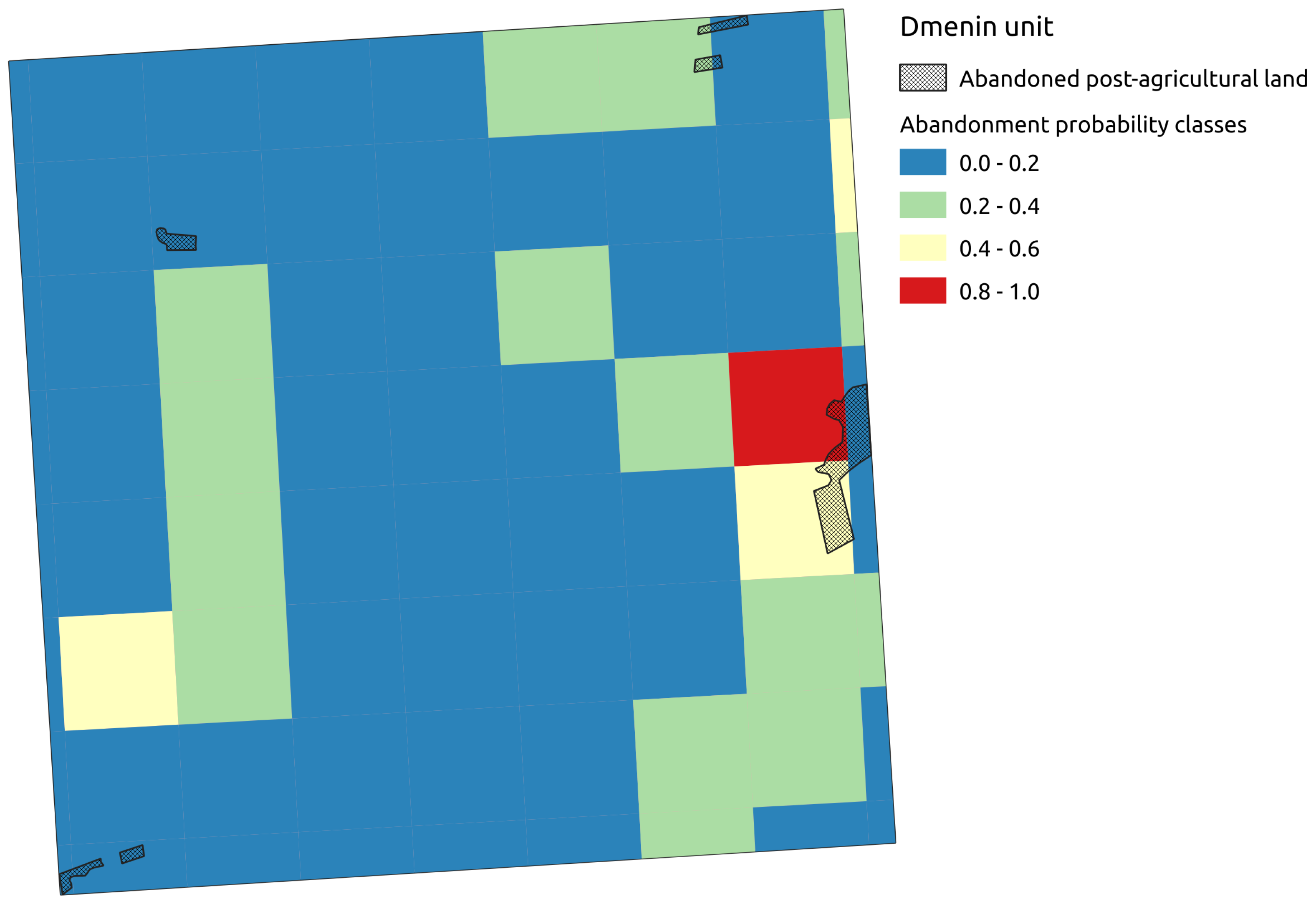
- Adamczyk, J.; Krysiak, S.; Sieradzki, J. Abandoned land study plot groups in the buffer zone around landscape parks on the Pilica River. In The Ecological Role of Abandoned Agricultural Lands in Buffer Zones Around Landscape Parks in the Łódź Voivodeship; Krysiak, S., Adamczyk, J., Eds.; Wydawnictwo Uniwersytetu Łódzkiego: Łódź, Poland, 2016; pp. 42–71. [Google Scholar]
- Krysiak, S. Abandoned lands around landscape parks on the Pilica River (Przedbórz Landscape Park, Sulejów Landscape Park, Spała Landscape Park). In The Ecological Role of Abandoned Agricultural Lands in Buffer Zones Around Landscape Parks in the Łódź Voivodeship; Krysiak, S., Adamczyk, J., Eds.; Wydawnictwo Uniwersytetu Łódzkiego: Łódź, Poland, 2016; pp. 15–21. [Google Scholar]
- Majchrowska, A.; Adamczyk, J.; Sieradzki, J. Abandoned land study plot groups in the buffer zones around the Bolimów Landscape Parks and the Łódź Hills Landscape Park . In The Ecological Role of Abandoned Agricultural Lands in Buffer Zones Around Landscape Parks in the Łódź Voivodeship; Krysiak, S., Adamczyk, J., Eds.; Wydawnictwo Uniwersytetu Łódzkiego: Łódź, Poland, 2016; pp. 99–126. [Google Scholar]
- Papińska, E.; Adamczyk, J.; Sieradzki, J. Abandoned land study plot groups in the buffer zone around the Sieradz landscape parks. In The Ecological Role of Abandoned Agricultural Lands in Buffer Zones Around Landscape Parks in the Łódź Voivodeship; Krysiak, S., Adamczyk, J., Eds.; Wydawnictwo Uniwersytetu Łódzkiego: Łódź, Poland, 2016; pp. 72–98. [Google Scholar]
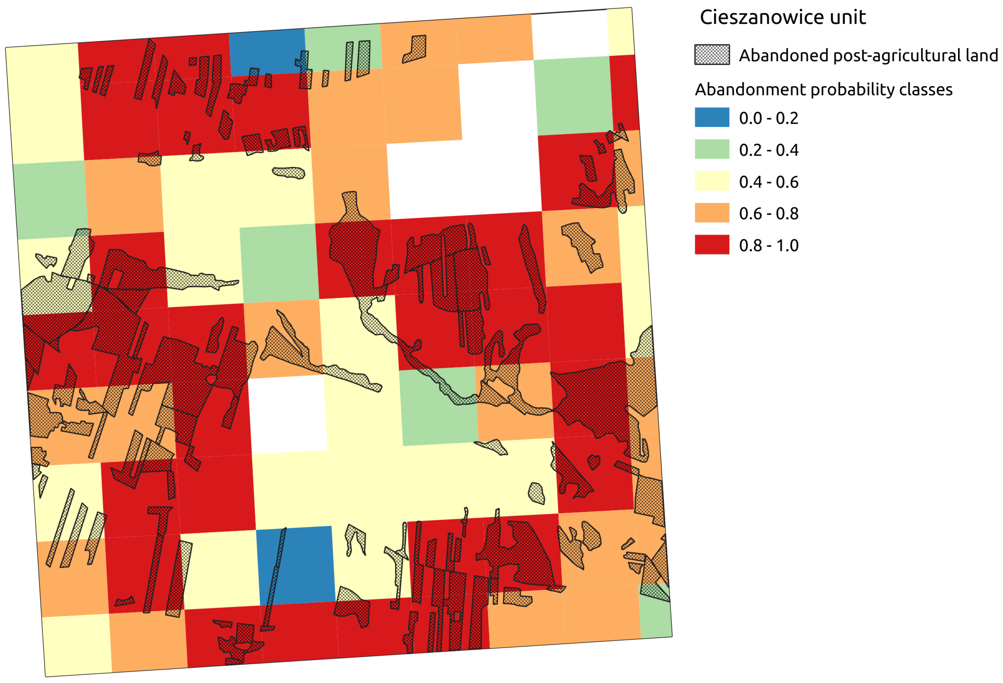
- Szymczyk, M.; Krysiak, S. Przemiany krajobrazu doliny Luciąży i jej otoczenia po utworzeniu zbiornika retencyjnego Cieszanowice. Acta Univ. Lodz. Folia Geogr. Phys. 2018, 17, 41–50. [Google Scholar] [CrossRef]
- Wągrowski, S. Rzejowice sheet. In Szczegółowa Mapa Geologiczna Polski 1:50000; Wydawnictwa Geologiczne: Warszawa, Poland, 1983. [Google Scholar]
- Krysiak, S. The influence of periglacial cover deposits upon aeration and moisture conditions of geocomplexes. Biul. Peryglac. 1996, 35, 87–120. [Google Scholar]
- Isola, P.; Zhu, J.Y.; Zhou, T.; Efros, A.A. Image-to-Image Translation with Conditional Adversarial Networks. arXiv 2018, arXiv:1611.07004. [Google Scholar]
- Huynh, D.N.T.; Neptune, N. Annotation automatique d’images: Le cas de la déforestation. CORIA 2018. [Google Scholar] [CrossRef]


| Prediction/Classification | Nonabandoned | Abandoned |
|---|---|---|
| nonabandoned | 22,556 | 3496 |
| abandoned | 6328 | 12,219 |
| Symbol in Figure 8 | Name | Location | Surface in km2 |
|---|---|---|---|
| A | Central | Surrounding Łódź, Zgierz, Zelów, Szczerców, and the Szczerców Field of Bełchatów Lignite Mine, areas along the Warta river from the vicinity of Strońsk, through Chojne, until the southernmost suburbs of Sieradz and the vicinity of Hipolitów on the Pisia river | 2025.25 |
| B | Kamieńsk | East of Bełchatów, southwest of forest complexes and Gomunice, spanning along the railway from Radomsko towards Kamieńsk and subsequently northwards of the Widawka river valley | 292.5 |
| C | Grębienice | Southeast of the Łódź voivodeship, near Grębienice-Nowa Góra, and south of Żarnów | 254.5 |
| D | Tomaszów Mazowiecki | Along the Plica river valley and near the Spalski and Sulejowski Landscape Parks | 238 |
| E | Gidle | Southern Łódź voivodeship, stretches North–South along the Warta and Stara Wiercica river valleys | 158 |
| F | Skierniewice Interchange | Along the western border of the Bolimów Landscape Park and near sparsely forested areas, enveloping the A2 motorway | 147.75 |
| G | Struga Węglewska | SW portion of the Łódź Voivodeship, interfluve of Struga Kraszewicka, Struga Węglewska, and Prosna rivers. NE from Wieruszów | 138.75 |
| H | Ożegów-Rząśnia | Neighborhood of the Oźegów and Rząśnia localities, stretching east to west | 117 |
| I | Rawa | South of Rawa Mazowiecka and the upper Rawka and Rylka river valleys, stretching latitudinally | 110.5 |
| J | Działoszyn | South of the Warta river, chiefly east of Grabia river, extending towards Działoszyn and subsequently curving in the SE direction | 101.25 |
| K | Nowy Dwór | Stretching longitudinally on the E side of the Rawka valley and along the Białka valley | 90.25 |
| L | Strobin | Running NW–SE between the localities of Oleśnica and Osina | 88 |
| M | Drzewica | Extending alongside the eastern border of the voivodeship, between the Ossa and Rozwady villages, centered on the Drzewica locality | 71.75 |
| N | Petrykozy | Near the voivodeship’s eastern border, SE of Opoczno, along the Młynkowska and Drzewiczka river valleys, centered on Petrykozy | 59.75 |
| O | Grabina | Between the Pichna and Urszulinka rivers, westward of Zadzim | 53.25 |
| P | Kliczków | Stretches latitudinally between the Izabela and Kije localities | 50.5 |
| Symbol in Figure 8 | Name | Location | Surface in km2 |
|---|---|---|---|
| a | Northern | Mostly within the northern part of the voivodeship, including the Warsaw-Berlin Urstromtal and the surroundings of Ozorków, Łęczyca, extending towards Łowicz | 2055 |
| b | Piotrków Trybunalski | Elongated along the N–S axis, bounded by the Piasecznica valley from the north and the Bogdanówka valley from the south, centered on the localities of Moszczenica and Wolbórz | 554 |
| c | Wieluń | SW portion of the voivodeship, near Wieluń | 459.75 |
| d | Błaszki-Warta | West of the Warta valley, in the vicinity of the Jeziorsko reservoir, delimited by the voivodeship’s western border. Highly contiguous | 429.75 |
| e | Jeżów | Centered on Jeżów | 372.75 |
| f | Przedbórz-Radomsko | Elongated along the W–E axis, in the southern portion of the voivodeship, extending as far west as Radomsko and as far east as Przedbórz | 169.5 |
| g | Chodnów | Near Biała Rawska and Chodnów, to the east of the Central Rail Line, adjacent to the eastern border of the voivodeship | 164.75 |
| h | Szadek | Relatively compact, between the town of Szadek to the south and Poddębice to the north | 70.07 |
| i | Sadykierz | Bordering the Spalski Landscape Park’s forests southward and the Luboczanka valley northward. Contains the localities of Sadykierz and Rzeczyca | 66.50 |
© 2020 by the authors. Licensee MDPI, Basel, Switzerland. This article is an open access article distributed under the terms and conditions of the Creative Commons Attribution (CC BY) license (http://creativecommons.org/licenses/by/4.0/).
Share and Cite
Krysiak, S.; Papińska, E.; Majchrowska, A.; Adamiak, M.; Koziarkiewicz, M. Detecting Land Abandonment in Łódź Voivodeship Using Convolutional Neural Networks. Land 2020, 9, 82. https://doi.org/10.3390/land9030082
Krysiak S, Papińska E, Majchrowska A, Adamiak M, Koziarkiewicz M. Detecting Land Abandonment in Łódź Voivodeship Using Convolutional Neural Networks. Land. 2020; 9(3):82. https://doi.org/10.3390/land9030082
Chicago/Turabian StyleKrysiak, Stanisław, Elżbieta Papińska, Anna Majchrowska, Maciej Adamiak, and Mikołaj Koziarkiewicz. 2020. "Detecting Land Abandonment in Łódź Voivodeship Using Convolutional Neural Networks" Land 9, no. 3: 82. https://doi.org/10.3390/land9030082
APA StyleKrysiak, S., Papińska, E., Majchrowska, A., Adamiak, M., & Koziarkiewicz, M. (2020). Detecting Land Abandonment in Łódź Voivodeship Using Convolutional Neural Networks. Land, 9(3), 82. https://doi.org/10.3390/land9030082