Article

Actors, Scales and Spaces Dynamics Linked to Groundwater Resources use for Agriculture Production in Haouaria Plain, Tunisia. A Territory Game Approach

1
INRGREF, University of Carthage, Ariana 2080, Tunisia
2
INRAT, University of Carthage, Ariana 2080, Tunisia
3
INAT, University of Carthage, Ariana 2080, Tunisia
4
INRAE & AgroParisTech, UMR Territoires, 63178 Aubière CEDEX, France
*
Author to whom correspondence should be addressed.
Submission received: 3 February 2020 / Revised: 26 February 2020 / Accepted: 2 March 2020 / Published: 5 March 2020

Abstract

:
Groundwater resources became a recognized enabler of important rural and socio-economic development in Mediterranean countries. However, the development of this groundwater economy is currently associated with an increased pressure on the available resource and negative implications on the socio-ecological system. Managing complex socio-ecological systems, such as those that occur in water resource management, is a multi-actor, multi-scale and dynamic decision-making process. This study aims to build a collective learning and collaborative construction tool through the territory game method. It was implemented in the Haouaria Plain, in Northern Tunisia, where farmers are currently dependent upon groundwater use for their livelihood and food security. After the diagnosis of the territorial issues, the drivers of change and a common spatial representation of the future trend of the territory, we dive into the dimensions that hinder or facilitate the implementation of scenarios and the pathways of actions. Thereafter, we analyzed these dimensions together again and reflect on the interactions among actors at different levels to transform the local territory. From the perspective of evolution scenarios for the Haouaria plain, the participants indicated the conditions that hinder or facilitate their implementation and they proposed twenty-three possible actions to be carried out in order to achieve the desired trends. They indicated how these propositions can be achieved, by whom, and where. The local stakeholders coordinate actors, activities and spaces on their territory. Spaces such as El Garâa basin, littoral forest or food processing companies are at stake to develop an integrated response to territorial issues.

1. Introduction

Environmental degradation, energy crisis and climate issues are forcing policy-makers to rethink the current model of agriculture. Agriculture activities are currently undergoing an industrialization process, based on the intensive use of synthetic and mining input and irrigation water, leading to significant environmental damages [1]. We can take as an example of these damages the degradation of the groundwater resources. In order to meet the increase in irrigation water demand and to contribute to regional food security, groundwater resources serve as the main source of intensive irrigation [2,3]. However, the development of this groundwater economy has led to a progressive depletion of groundwater resources in many important food-producing regions. Such an intensive groundwater use will jeopardize a long-term sustainable water supply and associated food production [4].
Despite the economic importance of groundwater irrigated agriculture, viable strategies for effective water resource governance have not been forthcoming. Farmer scale development has not been coupled with an adequate management from governmental water authorities [5]. Groundwater irrigation around the world is driven by market forces and the private economy. Groundwater users respond individually or collectively to opportunities identified in the food market with little or no planning or control by water authorities [6].
Failure of groundwater management often results from inadequate governance arrangements, rather than from lack of knowledge about sustainable yield or pollution vulnerability of aquifers [7]. Managing complex territory, such as those that occur in groundwater resource management, is the most challenging resulting from a multi-actor, multi-scale and dynamic decision-making process. Such a complex territory process involves a diversity of stakeholders integrating the local and the global and issues surrounding the public and private coordination of goods. However, rural communities have limited insight into their institutional context. Therefore, attention must be paid to groundwater governance, particularly in contexts, where the institutions are fragmented or overlapping [8]. With respect to territorial governance, two key elements must be noted [9]: (i) the need to facilitate places and moments of dialogue between the different actors involved, to co-constructing development processes, and (ii) to ensure support for intermediary actors that were not necessarily foreseen at the outset, but which emerged during the course of the process.
Over the past decade, international research and policy have been increasingly recognizing the need for more integrated research, planning and management of water, energy and food systems to address the interconnected risks to water, energy, and food security. The need to manage resources in an integrated way has never been as urgent as it is today. Understanding their interplay is essential to effectively addressing sustainability challenges. Furthermore, managing food and water is key to achieving the Sustainable Development Goals and requires a better understanding of the interactions between the goals, both at and across different scales. Providing decision-makers with the multifaceted knowledge needed to seize all opportunities to enhance synergies and minimize trade-offs is, therefore, a major objective for sustainability science. Over the past decade, serious games were designed and used in the governance of natural resources and the environment [10] for research and data collection, teaching and training, and fostering a change of practices. The use of collective games is innovative to not only evaluate propensity for cooperation, but to improve local understanding of groundwater interrelationships and stimulate collective governance of groundwater [11]. Many stakeholders are involved in the management of projects (individual and collective, institutional or professional, organized or associated) and have different visions on current and past dynamics and issues. Broad-scale, multi-governance level, participatory water management processes are multiplying around the world [12]. One aspect of this purpose is the role that researchers could play in the smart development approach [13]. Academic debate continues over the conditions under which participatory governance and policy measures can effectively be implemented by giving examples of various sectors and regions [14,15,16,17]. In combination with local knowledge, scientific knowledge can contribute to a more comprehensive understanding of complex and dynamic natural systems and processes [18]. Implementing the territory game in a variety of real situations has proved its relevance in enhancing the expression of points of view and comparing ideas-proof of better collective appropriation of a territorial development project [9,18].
Examples of ineffective institutional arrangements can be found in Haouaria plain (northeastern Tunisia). Growing pressures on natural resources are making the interdependencies and trade-offs between food, water and energy systems, and their interactions with land, climate change and livelihoods, increasingly evident. Here, urbanization is rapid and largely unregulated. Conflicts have also emerged between agricultural and industrial water users over access to groundwater. Declining groundwater levels and increasing salinity, industrial pollution and contamination is also reported in this region. Together, this provides a clear signal that existing institutions are unable to support sustainable or equitable water management outcomes. This paper presents a local case study developed in the Haouaria Plain, in the framework of the Arimnet2 project DIVERCROP (Land system dynamics in the Mediterranean basin across scales as relevant indicator for species diversity and local food systems). The purpose of this project is to characterize the current spatial agricultural dynamics, linked to the groundwater use, trends and impacts on agricultural practices, species diversity and local food systems. We chose to apply a territory game in the Haouaria plain, where farmers are currently dependent upon groundwater use for their livelihood.
Despite the inherent interconnectedness of food and natural resources (water, energy, etc.), little effort is made to understand the interdependencies in terms of resource use and policies. Understanding and managing the links among food, water and energy is essential for formulating policies for more resilient and adaptable societies [19]. This paper seeks to explore and understand the links between sustainable food systems and preservation of natural resources in the Haouaria plain. It aims to build a collective learning and collaborative construction tool through territory game method for building common representations of the future of the territory, perceived by local actors and planned by more global decision-makers.

2. Materials and Methods

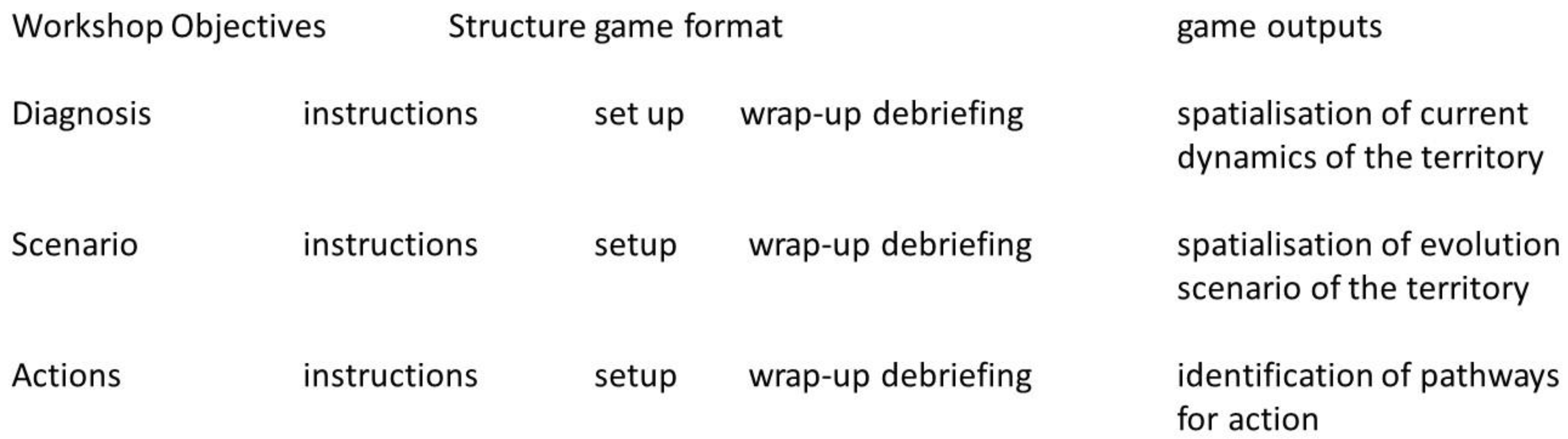
2.1. The Territory Game Concept and Design

According to [18], the “territory game” is an expression game that promotes the construction of a shared viewpoint of the territory, production of knowledge for action is carried out as a part of an iterative process, in which the knowledge of actors and of researchers is shared and appropriated. The territory game is a concertation tool between territory stakeholders, it aims to support territorial development processes [17]. The territory game is based on an analysis of the main organizers of the space expressed as graphic models that serve as the thread for comparing and integrating the knowledge generated throughout the procedure. The process is structured by three phases of reflection and argument: diagnosis, scenarios of change and pathways of actions [18]:
(1) Performing a diagnosis and specifying the issues with participants: this first stage is aimed at drawing a portrait of the territory and identifying issues -> tracing their representation of the dynamics of the territory;
(2) Imagining scenarios of change: the second stage is based on a combination of dynamics that show possible future horizons -> tracing scenarios of evolution of the territory: an expression of the changes hoped for or feared by the stakeholder;
(3) Defining the setting of possible actions (pathways of action): identifying conditions that hinder or facilitate the implementation of each scenario -> identifying the actions to be carried out in order to achieve the trends desired.
The construction of playing cards to detail the transition pathway, the global cognitive map, summaries of the productions of the process, action plans, and so on, all constitute varied illustrations of the design and redesign of an interactive and didactic process. It is valid to say that the process generated multiple outputs. The role of actors can be to provide information, to give their opinion, or to co-construct or even drive forward the action; that of researchers can be to facilitate participation, formalize productions, or even co-construct [9].

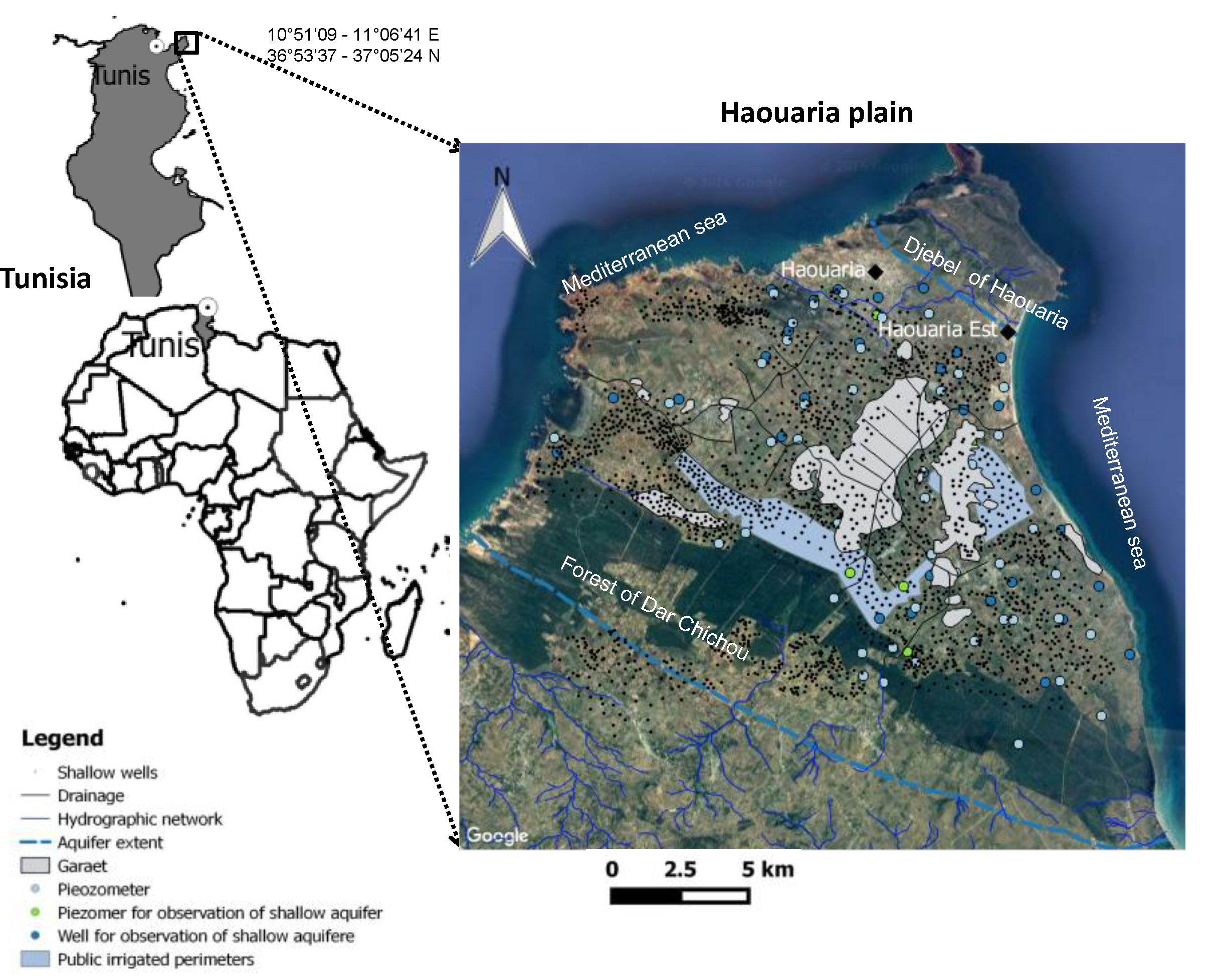
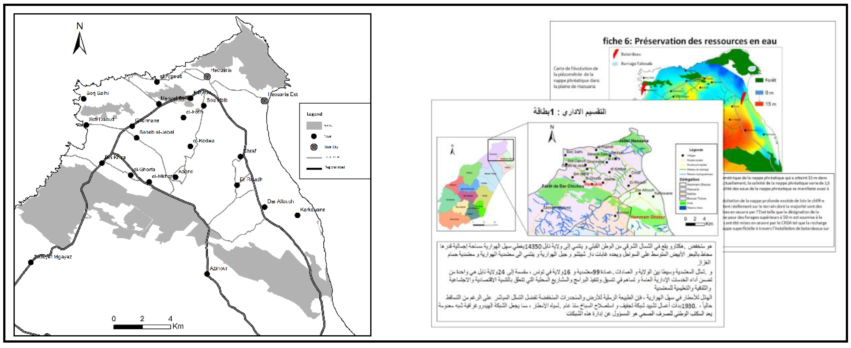
2.2. The Haouaria Plain in the Cap Bon, Tunisia

The study focuses on the plain of Haouaria (300 km2), located in the Cap Bon in north-eastern Tunisia (Figure 1). The plain is surrounded by the forest of Dar Chichou and Djebel Haouaria, and the Mediterranean Sea on both sides. The climate is Mediterranean upper sub-humid, with irregular precipitation and wind 300 days per year on average. The annual rainfall is about 568 mm/year (1972–2007). Agriculture remains the main economic activity in the Haouaria region, with almost 70% of its population involved in this activity [20]. The major crops in the region are irrigated (tomatoes, potatoes, pepper, spices, peanuts and citrus) and rainfed cropping systems (cereals, fodder, fallow and olive orchards). The agricultural development relies on groundwater resources which are currently suffering from depletion and quality deterioration of the shallow and deep aquifers. According to recent estimates, recharge for the shallow aquifer represents 33 Mm3 per year and 5.2 Mm3 per year for the deep aquifer [21]. The exploitation increased between 1970 and 2006 fivefold for the shallow aquifer and twofold for the deep aquifer, respectively [22], has led to the qualitative and quantitative degradation of water resources in the plain. A decrease in piezometric levels of 13 m has also been observed between 1991 and 2004 in the deep aquifer [21]. The piezometric heads of all the shallow aquifer have gone down drastically. In Haouaria, landownership is highly fragmented due to population increase and landowners processing. The number of farmers is about 6000 [23].
Since 1975, the Ministry of Agriculture in Tunisia is in charge of water management, assisted by two bodies, the National Water Council and the Commission of the Public Water Domain. Within the Ministry of Agriculture, several technical departments are involved in the management of water resources. The most important are as follows: (i) in each governorate, the Regional Commission for Agricultural Development (CRDA) is the decentralized body representing the Ministry of Agriculture. It has financial autonomy and is responsible for the implementation of policies from the Ministry, and (ii) water users associations called “GDA” sharing one aquifer in competition with each other as well as with other users. There are no structures that work linking the different GDAs in one aquifer system together, making joint monitoring and rule-making difficult given the absence of coordination [24].
We note the insertion within existing processes (new role for the municipal counselors’, water code in discussion) are favorable conditions that the territory game design should be applied to use by decision makers.

2.3. Data Collection, Preparation and Implementation of the Territory Game

Data Collection
The construction of playing cards thematic and the Haouaria plain maquette are based on the data collected during field visits in 2015 and 2017 within the framework of previous project on groundwater governance [25,26,27]. The 2015 field visit comprised 30 key informant interviews with farmers, 10 government agencies, seven suppliers and the non-governmental organizations. During this time, discussions covered the institutions, actors, interactions, and outcomes associated with water management. Participatory workshops were also organized with water management actors and the administration. The discussions helped to clarify: (i) whether there really are coordination challenges related to water management, (ii) in which fields institutions fail to address water related social dilemmas, and (iii) the historical or current rules and norms farmers refer to. The second field visits in 2017 was used to identify actors conducted as part of the project DIVERCROP that aims to characterize the current spatial agricultural dynamics, linked to the groundwater use, trends and impacts on agricultural practices, species diversity and local food systems.
Together, this information helped us to design the territory game and to identify the actors to be invited to participate.
Preparation of the Territory Game
Cartographical and statistical material made from previous projects and government websites and reports were combined with qualitative data collected from the interviews conducted in the project. This information was used, according to the game protocol as presented by [18], to prepare the game supports: a maquette of Haouaria Plain territory and the playing cards (Figure 2). While the maquette provides a summary view of the geographic structure of the territory, each game card focused on a thematic information on the territory. Sixteen playing cards were produced and were translated into the local language (Arabic), as the game involves farmers. The playing cards cover the following thematic: administrative limits, urbanization, road infrastructure, agriculture, exploitation and water resources management, water resources preservation, forest and land, agro-industries (products, processing), conditioning units, suppliers, distribution channels, local initiatives, tourism, supervision and advise, employment and the sector of activities, energy, and landscape and environment. The cards we grouped by moderators in six packages composed of two or three cards as explained in Table 1.
A test session was conducted at laboratory with researchers in September 2018. A half-day training session was held with facilitators at the National Institute for Agronomic Research of Tunisia offices in Tunis to familiarize them with the game and other provided supporting materials, such as the facilitator script.
Implementation of the Territory Game
The territory game was played at a half-day participative workshop held on 27 September 2018 at the mechanical fishing center in Kelibia city, Cap Bon. The workshop was attended by 27 participants that were invited formally. Participants represented key stakeholders’ groups from the community, 12 participants were from local administrations and water users’ associations (CRDA, GDA, municipality, etc.), five participants from different associations (e.g., rural woman association, etc.), one research engineer, four farmers and one supplier were also present. However, the invited agro-industrial investors such as food processing companies’ directors were absent. The participants were distributed in three tables, each of them animated by a research facilitator and observed by one observer who recorded workshop proceedings. A main facilitator conducted the workshop and two co-facilitators organized game materials, assisted participants, and recorded discussions during the game debriefings. The game designer (Sylvie Lardon) was also present to answer questions related to the game or workshop activities.
The overall workshop design, including its structure, specific activities, and time management plan is shown in Figure 3. Three steps were performed. The first one is the diagnosis of the actual situation: each player, at turn, choose one of the 2–3 cards he has in hand, explain to the others the information he wants to share, discuss with them about the thematic of the card and decide what to draw on the maquette which is in the middle of the table. They then fulfill the legend of the map. Therefore, each player participates to the construction of the diagnosis map. A second round is done to add important information. At the end of the step, the players choose a title for their map and one of them presents their diagnosis to the other tables. The second step is the expression of an evolution scenario of their territory, by forcing the line of the dynamics in progress. The players discuss and draw collectively, then choose a title for their map of scenario. At the end, the scenarios are presented to the others players. The third step is the listing of actions. Participants indicated the conditions that hinder or facilitate the implementation of their scenario and they proposed actions to be carried out in order to achieve the desired trends. They specify the action, its localization and the actors that are able to achieve it.

2.4. Analysis of the Territory Game Results

The present study, based on participants’ discourses, have been completed by a direct analysis of the exchanges carried out during a workshop with researchers and trainers. This workshop was organized after the territory game session (Figure 4). The outputs of the territory game are analyzed from the angle of the concerns that they address [9]. Analyzing the content of the discussions allowed us to characterize the socio-spatial configurations and to identify the main dynamics (from the diagnosis map) and the key issues (interpretation of the scenario map). We analyzed the actions proposed during the workshop, according to these main issues and spatialized them.

3. Results and Discussion

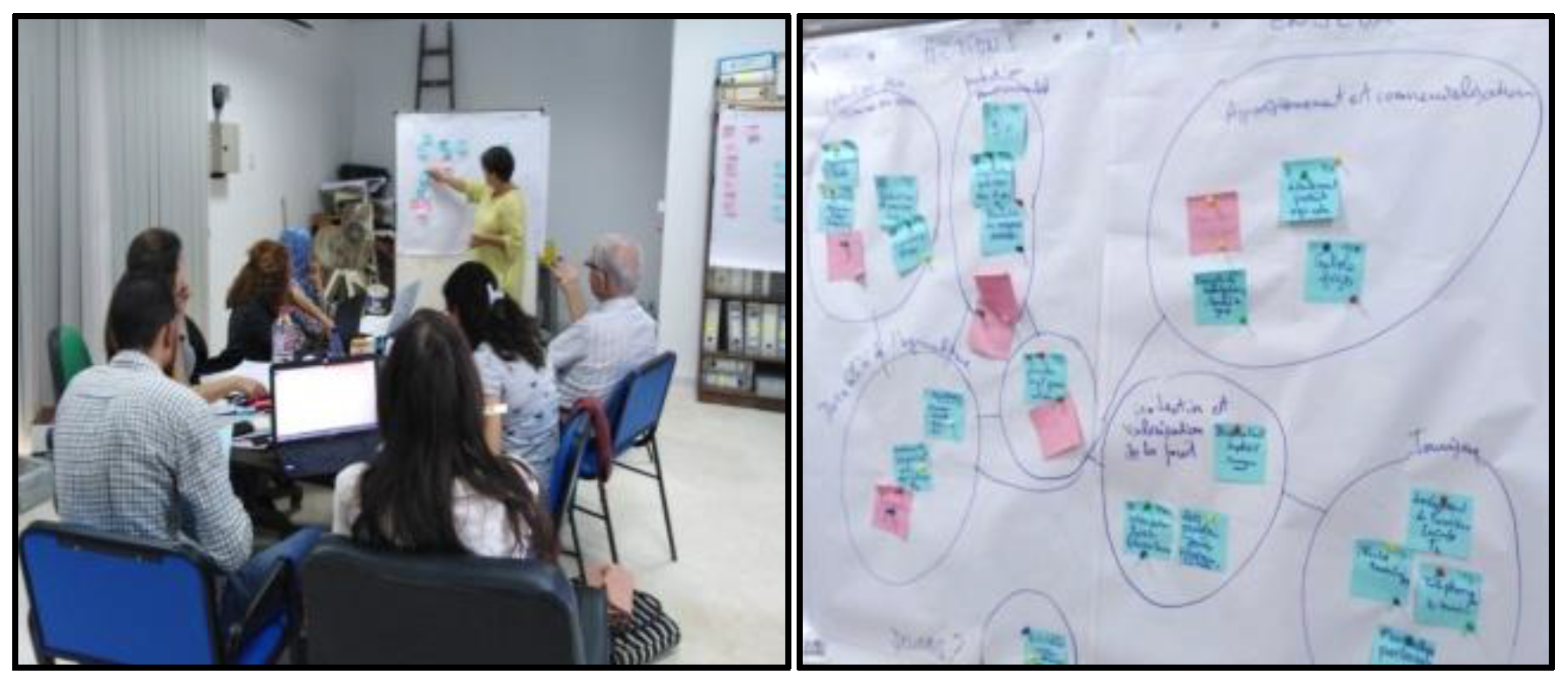
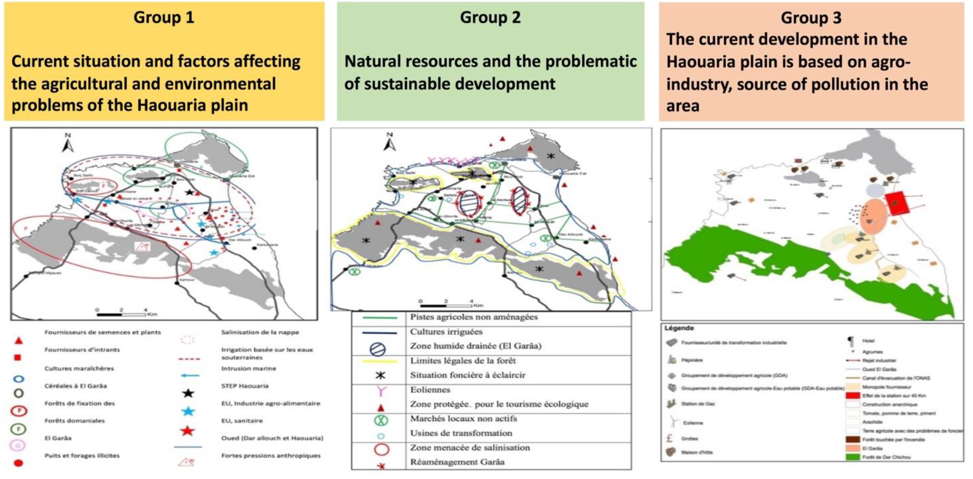
3.1. Results of the Territory Game Workshop

3.1.1. Choice of the Thematic Cards

During the workshop, the actors were really engaged in the process. The priorities of local stakeholders were investigated first from their choice of the thematic cards. We noticed that five thematic cards were not chosen by participants in the three groups: urbanization, conditioning units, local initiatives, supervision/formation/advise and employment and sector of activity (Table 2). At the same time, players focused on certain cards themes such as “agriculture” and “forests and lands”, which were selected in the three groups. “Exploitation and water resources management”, “water resources preservation” and “providers” were chosen at least by two groups.
The presence of environment protection associations leads to a certain focus on the ecotourism, renewable energy and environment, however the preservation of the agriculture, the protection of natural resources (water, land and forests) and the resolution of commercialization problems turned out to be the main objectives of participants. This implies that the concept of sustainable rural development may not be understood in the same way by all the stakeholders in the same space. We noticed that despite the presence of many representatives of the local administration (e.g., CRDA) and some cultural associations, the themes cards of formation, local initiatives, employment and culture weren’t selected in any groups. This implies that the participants perceive some subject as the formation or the reinforcement of local initiatives as the central administration and politicians’ responsibilities. Despite the post-revolution context in Tunisia, which stressed the importance of the local development, the discourse around the management and protection of natural resources, such as the water, is still dominated in Tunisia by technical propositions [25].

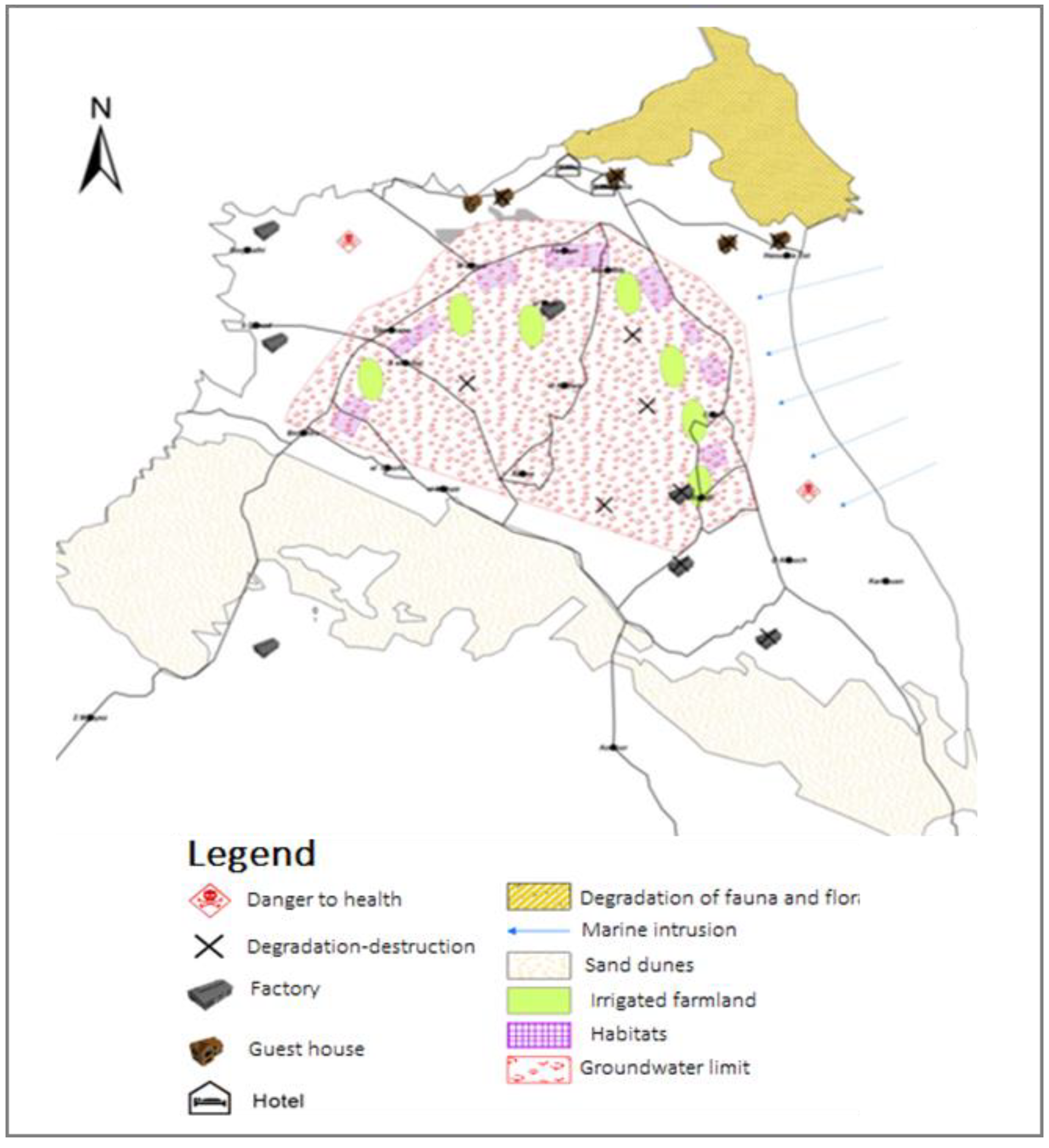
3.1.2. Diagnosis of Actual Situation and Actors’ Perception of Territorial Dynamics

Figure 5 shows the three groups representation of the dynamics of the territory in the game. They revealed three main issues in the Haouaria Plain: (i) farming system sustainability issues which are firmly associated with limited water resources, land fragmentation and increasing urbanization, (ii) problems related to agricultural products’ marketing and trade monopolies and (iii) pollution issue caused by agricultural activities and industrial discharges in rivers and in El Garâa and leading to the degradation of natural resources and reduction of available farming land.
For the first issue, participants explained that the surface water resources are limited in the Haouaria Plain, which explains the strong pressure on groundwater resources. Most farmers resorted to an intensive abstraction of the phreatic and the deep groundwater resources. In addition to these water resources management problems, there are land problems in agricultural and forest areas. The plain is marked by its small fragmented and scattered farms that may disappear to the benefit of urban areas. This urban development is also starting to affect the forests of Dar Chichou. The second issue, is the result of the existence of a large number of suppliers, who are both owners of plant nursery, food processing companies and providers of inputs and seeds. This situation of monopoly imposes major problems for farmers. Small producers struggle to access the agricultural inputs market. They are in a continual dependence towards these providers and can easily accumulate debts. The pollution in the region was perceived by participants as the result of these two issues. Because of their discharges in El Garâa and rivers, the food processing companies are among the main sources of pollution in the region. The plain is perceived by the participants as a former agricultural pole which is becoming a tourist and industrial center. Participants indicated that there is a current tendency to develop the local and ecological tourism in the plain (through guest houses, ecological farms, ecological trails, etc.) and an effort from the state to reinforce the use of renewable energy through the construction of Sidi Daoued wind park.

3.1.3. Future Scenarios

While the first and third groups drew catastrophic scenarios, the second group opted for an ideal future. The scenario for the first group entitled “desertification, pollution and loss of all activities in the Haouaria Plain”, described a future where there is a severe degradation of water quality and availability: the salinity of water will further increase and it will no longer be possible to exploit the groundwater resources. Agricultural and forest areas will suffer from desertification. There will be no more suitable land for agriculture. There will be no more water resources to ensure a natural recharge of the water table.
The second group had an optimistic vision for the Plain future. Their scenario entitled “the new economy” described the development of the Garâa Basin, preservation of the forest used for local projects, consolidation of agricultural land in production basins and improvement of local and touristic infrastructure (coastal road, cable car, cultural complex).
The third group expressed their fear for the future of next generations as they named their scenario: “what legacy have we left? The future of El Haouaria without improvement actions”. Figure 6 illustrates this scenario focused on a total destruction of the ecosystem that will have socio-economic impacts on the plain. A marine intrusion will affect the coastal zone, forests and groundwater. The continuing degradation of groundwater resources will lead to the increase of the salinity and pollution of the irrigation water. The agricultural areas and forests of Dar Chichou will disappear completely. As a result, food processing companies and most suppliers will be looking for other areas outside the Haouaria plain. The pollution will affect plants, animals, and water, which will endanger even the health of humans. With all these pollution problems, tourism development is no longer possible. In the end, in this socio-economic situation, local people will have to move to another city or even they will immigrate.

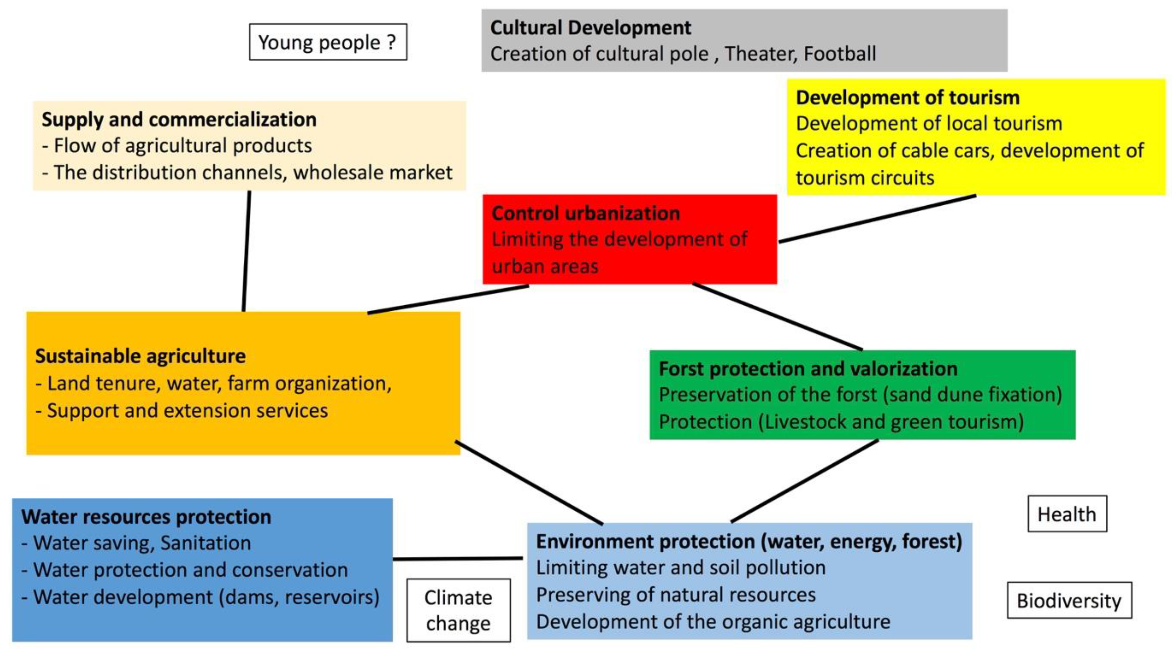
3.1.4. Drivers for Change: Levers and Obstacles for Scenarios Implementation and Actions Pathways

Participants from each group indicated conditions that hinder or facilitate the implementation of the scenarios that they proposed. Participants emphasized the need to strengthen water resources management policies, farmland protection laws and farmers’ collective organization, improving farmers’ access to agriculture markets, reforming regulated markets and providing farmers with alternative market opportunities. It seems that the levers of actions, for the local stakeholders, coordinate actors, activities, and spaces, such as El Garâa basin, littoral forest or food processing companies to develop an integrated response to territorial issues. Local initiatives and global dynamics involve preservation of agricultural land, water management, and territorial governance for an integrated development.
The main obstacles for a scenario such as “new economy in the plain” are degradation of natural resources (water, land, energy), commercialization difficulties (supply monopolization, difficult access to the local and national markets, etc.), urbanization pressure, low support of farmers from the state (lack of adequate funding), laws and regulations to protect and valorize forest lands are not applied and lack of infrastructure and support for the development of tourism in the region.
The discussion of levers and obstacles prepared participants for the identification of actions to be carried out to achieve the desired trends. Participants proposed twenty-three possible actions and indicated how these propositions can be achieved? by whom? and where?
The actions proposed by Group 1 relate mainly to water management: saving water, limiting pollution and cleaning up rivers. A variety of actors can contribute to this: state, municipality, but also factories, farmers and organizations such as GDA and researchers. Another action concerns the preservation of the forest which helps to fix the coastal dunes. Action to promote the flow of agricultural products by farmers has also been proposed, with the support of the private sector.
The actions listed by the Group 2 mainly concern the management of the pollutants and sanitation, improvement of land situation of agricultural holdings, management of forest areas, organization of farmers, valorization and control of water consumption. They insisted on the necessity of infrastructure amelioration for the commercialization, tourism and cultural sectors: the creation of a wholesale market, tourist route and cultural pole.
The actions proposed by Group 3 concern the protection of natural resources (water, soil, forest, energy), the support of the farmers and the protection of agricultural lands, as well as the development of eco-tourism.

3.2. Analyzing the Territory Game Outputs

3.2.1. Main Dynamics

The current dynamics traced and discussed by participants are summarized in Table 3. Through participants’ representations and discussion of current dynamics and issues in the territory, we presented factors of change and controversies associated with each dynamic. With respect to forest dynamic, two controversies are noted: the need to resolve land situation and the urban extension. The degradation of water resources in terms of quality and quantity induced by the increasing pressure on groundwater and other natural resources. Farmers resort to the exploitation of illegal wells, food processing companies are among the mains sources of pollution in the region because of their discharges in the Garaa river. To ensure support for tourism, there is a tendency to develop the local and ecological tourism in the plain (through guest houses, ecological farms, ecological trails, etc.). The situation of monopoly imposes big problems for farmers; there are many suppliers, who are owners of plant nursery, food processing companies and providers of inputs and seeds.

3.2.2. Summary of Key Issues and Proposed Actions

Eight main issues were identified during the game territory session: (1) the difficulties in the commercialization of agricultural products and the monopolization of supply and commercialization; (2) the deficiency in agronomic and socio-economic conditions threatened agriculture sustainability; (3) overexploitation of the groundwater pollution of water and absence of sanitation water resources management; (4) the absence of urban and industrial wastewater systems hindered the environmental protection (water, energy, forest) conditions; (5) complexity of forest lands status, forests degradation, forest protection and valorization; (6) anarchic extensions of cities and lack of urbanization control; (7) absence of tourism infrastructure, low support for ecological tourism impacted the tourism development; (8) lack of infrastructure, and cultural development not a priority for the state.
The identified issues involve a wide range of proposed actions (Figure 7). Hence, stakeholders need to combine different initiatives to cope with the challenges such as:
(1) Ensure the flow of agricultural products by improving farmers’ access to agriculture markets, reforming regulated markets and providing farmers with alternative market opportunities. As [9] emphasizes: “the territory is the place of interconnection between public policies and local initiatives.”
(2) Remove governance obstacles to long-term planning for land tenure and farm organization;
(3) Strengthen water resources management policies, farmland protection laws and farmers’ collective organization. This requires more effective stakeholder dialogue;
(4) Promote the development of organic-agriculture;
(5) Ensure more sustainable forest uses with the development of livestock and the green tourism;
(6) Limit the development of urban areas;
(7) Recommend local tourism that has the potential bring about significant improvements in the development of the territory;
(8) The creation of cultural pole and for the benefit of the greatest number of people.
Participants emphasized that the territory will be increasingly facing challenges due to young people unemployment, climate change, and the loss of biodiversity that exacerbates the vulnerability of the environment, threatening the health and the livelihoods of people.

3.3. Reflection on the Limitation and the Efficacity of the Territory Game Workshop

We are aware of the uncertainties in results in relation to the size of participants, however, this limitation is not problematic for two reasons. First, the large size of the population in the plain (6000) precludes the direct participation of all people in the workshop which requires significant investment in preparation, design, and implementation and goes beyond those explored in this project. Thus, we identified the representative of the different groups of stakeholders with responsibility for and knowledge of community development and natural resources management, with prioritization of young and female stakeholders. They were informed and invited to the workshop, and their participation depends on their motivation and interest contributing to make their interaction more effective and meaningful. Despite concerted efforts, representation of all potential stakeholders, including the food processing companies was not achieved, and representation was not always consistent across the workshops. Second, the aim of this study is a learning process rather than an actual planning process, the challenge was to promote integration between sectors, encourage knowledge sharing and help the stakeholders in inventing new options. As stated by [28,29], ‘participatory approaches are more likely to enhance the adaptive capacity of social learning’.
Despite the several simplifications resulting from a condensed representation of a complex system, the workshop results show a better understanding of the complexity and fragility of the territory as reported by different participants. The understanding of participants prior to the workshop was already fed by earlier interactions with the project researchers about groundwater governance problems [25,26,27]. Even then, through the territory game, we succeeded in communicating, to the local stakeholders, some of key insights about territory dynamics and issues, linked not only to the groundwater resources, as it included the management of natural resources in general (water, land and energy), food systems, environment and tourism. Participants were also concerned about public policies and strategies and their impact on the sustainability of their territory and on the resilience of farm systems, which allows us to identify not only technical and socio-economic actions but also institutional and social measures such as the reinforcement of land and water management regulations or State support to farmers.
The territory game showed participants and researchers the difficulty in maintaining the sustainability of farm systems and local food systems and to preserve the biodiversity of the Haouaria plain at the same time. However, these resources are easily accessible and intensively exploited by agro-industrial investors, considered as external actors to this territory. The agri-food system in this area is based on the development of production systems oriented to the export and high added value products without considering the importance of local food systems and the sustainability of small farms. That’s what participants expressed by saying “the only thing we received from the current development of the area is the pollution”.
Reinforcing communication between local and central stakeholders can be achieved through the creation of tools which can represent the actors’ logic, their action pathways, and their levers for action. Involving local communities with institutions and policy-decision makers in the territorial planning can be an example for a first step toward the development of successful policies that seek to increase the resilience of local systems while conserving natural resources [30]. The multiscale nature of issues means that problems escape the sphere of influence of local decision making [31]. In addition, the spatial consequences of decisions are often not taken into consideration, leading to external effects elsewhere than in the area that the decision itself focused on [31]. In the Haouaria plain, the local stakeholders coordinate actors, activities and spaces on their territory. Spatially, El Garâa basin, littoral forest or food processing companies are at stake to develop an integrated response to the territorial issues. Several cases using participatory approaches reviewed by [32], suggested there were challenges in participants understanding and accepting the need to consider multiple plausible futures and different ways of thinking across scales (regional, large scales, local communities).

4. Conclusions

The original contribution made by this study is to highlight the role of the spatial representation to support a participative approach, to explain the gap between actors’ perception and to provide action planning in relation with territory dynamics and issues. Even though the diversity of actors and scales, the territory game approach could be implemented as a suitable method to construct a shared vision of the territory over a short period with a good level of confidence. From the perspective of the territory dynamics three main issues are identified: (i) the land fragmentation and the increasing urbanization, (ii) the agricultural products’ marketing and the trade monopolies, and (iii) the pollution caused by agricultural and industrial activities. The local stakeholders emphasized the need to strengthen water resources management policies, farmland protection laws and farmers’ collective organization, reforming regulated markets and providing farmers with alternative market opportunities. From the perspective of evolution scenarios for the Haouaria plain, the participants indicated the conditions that hinder or facilitate their implementation and they proposed actions to be carried out in order to achieve the desired trends. Beyond spreading awareness of the great complexity of irrigated territories, the participation workshop used here facilitates the interaction of professional and scientific expert knowledge and local stakeholders’ skill levels. Such an approach can be used to extend the dialogue and understanding to community groups and policy-decisions makers beyond the workshop. The local stakeholders coordinate actors, activities and spaces on their territory. Spaces such as El Garâa basin, littoral forest or food processing companies are at stake to develop an integrated response to territorial issues. The linkages between these spaces are critical to assess dual outcomes for groundwater resources preservation and food security. The territory is the place of the interconnection between several biophysical and socioeconomic components, activities and uses, public policies and local initiatives. The territory approach relies on several simplifications resulting from a condensed representation of such a complex system. Future research should consider the driving factors beyond the borders of the territory to further improve the preparation of the stakeholders with new approaches of participation, the spatial and temporal scales needed for sustainable management of resources.

Author Contributions

Conceptualization, I.F. and I.M.; methodology, S.L. data collection, I.F. and I.M.; preparation of the maquette of Haouaria plain and the territory cards, I.F. and I.M.; workshop animation, all authors; analysis of the territory game results, all authors; writing—original draft, I.F. and I.M.; review; editing, I.F. and I.M. Project administration and funding acquisition, M.E. All authors have read and agreed to the published version of the manuscript.

Funding

This research was supported by the Arimnet2-funded regional project “DIVERCROP” (land system dynamics in the Mediterranean basin across scales as relevant indicator for species diversity and local food systems).

Acknowledgments

We gratefully acknowledge all the actors involved in water management in the Haouaria region (local extension services, farmers, water user associations, agro-food plants, suppliers, nurseries, associations, etc.) for their kind cooperation and for making data available and accepting to respond to our interviews. We thank all the participants to the territory game workshop for their time. We thank the assistants who contributed to the study, in particular, Insaf El Euchi, Rihab Mejri, Marwa Hajji, Najet Souissi, Brahim Chaieb and Mouadh Chebbi.

Conflicts of Interest

The authors declare no conflicts of interest.

References

  1. Therond, O.; Debril, T.; Duru, M.; Magrini, M.-B.; Plumecocq, G.; et Sarthou, J.P. Socio-Economic Characterization of Agriculture Models. Agroecological Transitions: From Theory to Practice in Local Participatory Design; Springer Nature: Basel, Switzerland, 2019; p. 335. [Google Scholar]
  2. Scanlon, B.R.; Faunt, C.C.; Longuevergne, L.; Reedy, R.C.; Alley, W.M.; McGuire, V.L.; McMahon, P.B. Groundwater depletion and sustainability of irrigation in the US High Plains and Central Valley. Proc. Natl. Acad. Sci. USA 2012, 109, 9320–9325. [Google Scholar] [CrossRef] [Green Version]
  3. Wada, Y.; Van Beek, L.P.H.; Bierkens, M.F. Nonsustainable groundwater sustaining irrigation: A global assessment. Water Resour. Res. 2012, 48. [Google Scholar] [CrossRef]
  4. Dalin, C.; Taniguchi, M.; Green, T.R. Unsustainable groundwater use for global food production and related international trade. Glob. Sustain. 2019, e2. [Google Scholar] [CrossRef] [Green Version]
  5. Llamas, M.R.; Martínez-Santos, P. Intensive groundwater use: Silent revolution and potential source of social conflicts. J. Water Resour. Plan. Manag. 2005, 131, 337–341. [Google Scholar] [CrossRef]
  6. Garrido, A.; Martínez-Santos, P.; Llamas, M.R. Groundwater irrigation and its implications for water policy in semiarid countries: The Spanish experience. Hydrogeol. J. 2006, 14, 340. [Google Scholar] [CrossRef]
  7. Foster, S.; Garduño, H. Groundwater-resource governance: Are governments and stakeholders responding to the challenge? Hydrogeol. J. 2013, 21, 317–320. [Google Scholar] [CrossRef]
  8. Gomes, S.; Hermans, L.; Islam, K.; Huda, S.; Hossain, A.T.M.; Thissen, W. Capacity building for water management in peri-urban communities, Bangladesh: A simulation-gaming approach. Water 2018, 10, 1704. [Google Scholar] [CrossRef] [Green Version]
  9. Lardon, S. TATA-BOX: A Model for Participatory Processes? In Agroecological Transitions: From Theory to Practice in Local Participatory Design; Springer: Berlin/Heidelberg, Germany, 2019; pp. 289–304. [Google Scholar]
  10. Rodela, R.; Ligtenberg, A.; Bosma, R. Conceptualizing serious games as a learning-based intervention in the context of natural resources and environmental governance. Water 2019, 11, 245. [Google Scholar] [CrossRef] [Green Version]
  11. Meinzen-Dick, R.; Janssen, M.A.; Kandikuppa, S.; Chaturvedi, R.; Rao, K.; Theis, S. Playing Games to Save Water: Collective Action Games for Groundwater Management in Andhra Pradesh, India. World Dev. 2018, 107, 40–53. [Google Scholar] [CrossRef]
  12. Daniell, K.A.; White, I.; Ferrand, N.; Ribarova, I.S.; Coad, P.; Rougier, J.; Hare, M.; Jones, N.A.; Popova, A.; Rollin, D.; et al. Co-engineering participatory water management processes: Theory and insights from Australian and Bulgarian interventions. Ecol. Soc. 2010, 15, 11. [Google Scholar] [CrossRef] [Green Version]
  13. Soulard, C.; Lardon, S. Action-Research Helps Researchers Foster Smart Rural Development: Two Case Studies on Local Food Policy. Syst. Pr. Action Res. 2019, 32, 155–166. [Google Scholar] [CrossRef]
  14. Caraveli, H. A comparative analysis on intensification and extensification in Mediterranean 473 agriculture: Dilemmas for LFAs policy. J. Rural Stud. 2000, 16, 231–242. [Google Scholar] [CrossRef]
  15. Debolini, M.; Marraccini, E.; Dubeuf, J.P.; Geijzendorffer, I.R.; Guerra, C.; Simon, M.; Targetti, S.; Napoléone, C. Land and farming system dynamics and their drivers in the Mediterranean Basin. Land Use Policy 2018, 75, 702–710. [Google Scholar] [CrossRef]
  16. Angeon, V.; Lardon, S. Participation and governance in territorial development projects. The «territory game» as a local leadership system. Int. J. Sustain. Dev. 2008, 11, 262–281. [Google Scholar] [CrossRef]
  17. Lardon, S.; Marracini, E.; Filippini, R.; Gennai-Schott, S.; Johany, F.; Rizzo, D. Prospective participative pour la zone urbaine de Pise (Italie). L’eau et l’alimentation comme enjeux de développement territorial. Cah. Geog. Québec 2016, 170, 265–286. [Google Scholar]
  18. Lardon, S. Developing a territorial project. The ‘territory game’, a coordination tool for local stakeholders. FaçSADe 2013, 38, 1–4. [Google Scholar]
  19. Newell, E.B.; Marsh, D.M.; Sharma, D. Enhancing the resilience of the Australian national electricity market: Taking a systems approach in policy development. Ecol. Soc. 2011, 2, 15. [Google Scholar] [CrossRef] [Green Version]
  20. INS. Annuaire des Statistiques 1998–2010; Institut National des Statistiques: Tunis, Tunisia, 2010. [Google Scholar]
  21. SCET. Actualisation des Connaissances Hydrogéologiques et des Données Socioéconomiques for Haouaria Plain Tunisia; Tunisian Ministry of Agriculture: Tunis, Tunisia, 2006.
  22. CRDA-Nabeul. Annual Report of 2011 Activities; Technical Report; Regional planning Commission for Agricultural Development: Nabeul, Tunisia, 2011. (In French) [Google Scholar]
  23. CTV Haouaria. Data on Agriculture Monitoring in Haouaria Region 2015; Technical Report; Territorial Extension Unit: Haouaria, Tunisia, 2015. (In Arabic) [Google Scholar]
  24. Elloumi, M. La Gouvernance des Eaux Souterraines en Tunisie, Report No. 6; IWMI Project Publication ‘Groundwater Governance in the Arab World’; IWMI: Cairo, Egypt, 2016. [Google Scholar]
  25. Mekki, I.; Ghazouani, W.; Closas, A.; Molle, F. Perceptions of groundwater degradation and mitigation responses in the Haouaria region in Tunisia. Groundw. Sustain. Dev. 2017, 5, 101–110. [Google Scholar] [CrossRef]
  26. Ghazouani, W.; Mekki, I. Les Ressources en Eaux Souterraines de la Plaine de Haouaria, Tunisie: État Fragile, Acteurs Multiples et Nécessité d’un Changement Intégré, Report No.7; IWMI Project Publication ‘Groundwater Governance in the Arab World’; IWMI: Cairo, Egypt, 2016. [Google Scholar]
  27. Closas, A.; Molle, F.; Hernández-Mora, N. Sticks and carrots to manage groundwater over-abstraction in La Mancha, Spain. Agric. Water Manag. 2017, 194, 113–124. [Google Scholar] [CrossRef]
  28. Ballard, D. Using learning processes to promote change for sustainable development. Action Res. 2005, 3, 135–156. [Google Scholar] [CrossRef]
  29. Pahl-Wostl, C. Aconceptual framework for analysing adaptive capacity learning processes in resource governance regimes. Glob. Environ. Chang. 2009, 19, 354–365. [Google Scholar] [CrossRef]
  30. de Castro-Pardo, M.; Pérez-Rodríguez, F.; Martín-Martín, J.M.; Azevedo, J.C. Planning for Democracy in Protected Rural Areas: Application of a Voting Method in a Spanish-Portuguese Reserve. Land Rev. 2019, 8, 145. [Google Scholar] [CrossRef] [Green Version]
  31. Arts, B.; Buizer, M.; Horlings, L.; Ingram, V.; Oosten, C.V.; Opdam, P. Landscape Approaches: A State-of-the-Art Review. Annu. Rev. Environ. Resour. 2017, 42, 439–463. [Google Scholar] [CrossRef]
  32. Bosomworth, K.; Gaillard, E. Engaging with uncertainty and ambiguity through participatory ‘Adaptive Pathways’ approaches: Scoping the literature. Environ. Res. Lett. 2019, 14, 093007. [Google Scholar] [CrossRef]
Figure 1. Localization and key characteristics of the study area. Garaet/Garâa is a natural wetland [25].
Land 09 00074 g001
Figure 2. The game supports: the maquette and the playing cards (modified from [26]).
Land 09 00074 g002
Figure 3. Overview of the workshop structure.
Land 09 00074 g003
Figure 4. Analysis of the territory game outputs.
Land 09 00074 g004
Figure 5. Local stakeholders’ perception and representation of the territorial dynamics in the Haouaria plain (three groups).
Land 09 00074 g005
Figure 6. An example of scenario of change: “what legacy have we left? The future of El Haouaria without improvement actions” drawn by the second group.
Land 09 00074 g006
Figure 7. Classification of participants’ propositions of actions according to the eight main issues.
Land 09 00074 g007
Table 1. The playing cards.
N° of PackageN° of the Card, Thematic of the Card
13, Road infrastructure 10, Suppliers
24, Agriculture 9, Conditioning units
32, Urbanization 7, Forest and land14, Supervision and advise
41, Administrative limits12, Local initiatives16, Energy, landscape and environment
55, Exploitation and water resources management11, Distribution channels15, Employment and sector of activities
66, Water resources preservation8, Products, processing13, Tourism
Table 2. The playing cards choices by participants.
N° of CardThematic of CardN° of Choices in the Three Tables
4Agriculture3
7Forest and land3
5Exploitation and water resources management2
6Water resources preservation2
10Suppliers2
1Administrative limits1
3Road infrastructure1
8Agro-industries: products, processing1
11distribution channels1
13Tourism1
16Energy, landscape and environment1
2Urbanization0
9Conditioning units0
12Local initiatives0
14Supervision and advise0
15Employment and sector of activities0
Table 3. Overview of the main dynamics explored during the game.
ThematicDynamicFactors of Change
Forest-Complexity of forest land status
-Degradation of the forest
-Deforestation
-Urban extension
-Fires
Water resources-Overexploitation of groundwater
-The degradation of water quality
-Development of illicit wells
-Problems of pollution of water
Supply and commercialization-Difficulties in commercialization of agricultural products-Monopolization of supply and commercialization
Tourism-Absence of tourism infrastructure-Low support for ecological tourism

