Abstract
Mediterranean regions have experienced a shift from accelerated urban growth typical of a post-industrial phase to a more recent spatial delocalization of population and economic activities reflecting discontinuous settlement expansion, land take, and the abandonment of cultivated areas around central cities. On the basis of a comprehensive analysis of land-use, settlement, and demographic indicators, the present study explores urban growth and population density over a sufficiently long time period in a metropolitan region of Southern Europe (Rome, Italy). Local-scale population trends were compared with the evolution of the primary sector (workers in agriculture, number of farms, cultivated land) between 1951 and 2011. Our results indicate non-linear growth waves alternating compact and discontinuous expansion shaping fringe land. The future development of metropolitan regions is increasingly dependent on the relationship between urban diffusion and economic viability of peri-urban agriculture. Crop abandonment and land take rates increase in local contexts where peri-urban agriculture rapidly declines. Policies managing ex-urban development and promoting the recovery of fringe soils are increasingly required to contain the expansion of dispersed settlements and preserve relict agricultural systems from land conversion to urban use.
1. Introduction
Population growth in the last century contributed to discontinuous urban expansion in Europe [1], and especially in traditionally compact settlements such as in Mediterranean countries [2,3,4,5,6]. For instance, the urban population increased significantly in Mediterranean Europe (from 150 million people in 1970 to more than 310 million people in 2010), as a direct consequence of industrial and tourism development, migration, and economic polarization in the most accessible, lowland districts [7,8,9,10,11,12,13]. Overcoming a balanced population distribution around rural villages and head towns shaped by a millenary history, Mediterranean cities have featured economic development with deregulated urban growth and the (partial) abandonment of the agricultural sector on fringe land [14,15,16,17,18,19,20]. More recently, these regions have experienced a transition towards zero (or negative) population increase [21], reflected in the progressive mismatch between urban expansion, demographic growth, and economic dynamics [22,23,24,25,26,27,28].
Spatially discontinuous, low-density residential settlements in peri-urban districts recently added to compact-dense metropolitan structures in Southern Europe [29,30,31]. Biophysical factors (topography, land availability, soil, climate, and the prevailing vegetation type) and contextual variables (economic structure, social dynamics, land tenure, migration, and ineffective spatial planning) together contribute to shaping the population dynamics in metropolitan regions [29,32,33,34,35]. Population growth has widened the socioeconomic gap between coastal (advanced) areas and internal (disadvantaged) districts, consolidating the urban–rural divide [36,37,38,39,40,41,42].
The recent history of Rome’s expansion was considered a paradigmatic example of the development path characteristic of contemporary Mediterranean cities. The recent history of Rome also supports the argument of an “individualized urban development”, as it portrays a city that keeps on growing in a partly undesigned fashion, based on small-property development schemes and spontaneous settlements with limited (or ineffective) expenditures for public infrastructure [43,44,45,46]. Accelerated demographic dynamics in Central and Southern Italian regions have been crucial in determining the rapid expansion of Rome, with internal migration being the most relevant factor of urban growth for a very long time period in Italy [47].
An empirical analysis of population dynamics over the last century provides useful information for understanding the recent evolution of Rome’s metropolitan area in relation to changes in the use of peri-urban land, a traditional agricultural system called ‘Agro Romano’ [48,49,50,51,52,53]. The exercise proposed in the present study provides a complete picture of Rome’s development based on the analysis of population dynamics, land-use, and the agricultural sector over a sufficiently long time period. Assuming that Rome’s expansion fuelled a socioeconomic divide in coastal and inland districts typical of Mediterranean regions [54,55,56], sequential waves of densification and de-concentration were identified as a result of new urban structures and the changing use of fringe land [16,57,58]. The empirical findings of this study were discussed in light of the current debate on the future development paths of Mediterranean cities and the relationship with the surrounding districts.
2. Methodology
2.1. Study Area
The investigated area covers statutory Rome’s metropolitan area (5355 km2) corresponding to the administrative province of Rome (Italian level) and the Nuts-3 prefecture of Rome (European level), according to the Eurostat Nomenclature of Statistical Territorial Units. A total of 122 Nuts-3 municipalities forming Rome’s metropolitan area were considered in this study, among which Rome’s municipality extends 1285 km2 (the largest municipality in Europe). Owing to its exceptional size, Rome’s municipality was further divided into 115 local districts with a similar extent to the other municipalities of Rome’s metropolitan area. The study area consists of nearly 30% lowlands (elevation < 100 m at the sea level), 50% uplands (100 m < elevation < 500 m at the sea level), and 20% mountains (elevation > 500 m at the sea level), with the most fertile lowlands (the so-called ‘Agro Romano’ district) being situated within the alluvial plain of the Tiber River. The climate is typically Mediterranean, with rainfall concentrated mainly in autumn and spring, and a mild temperature in winter. The average long-term (1961–1990) annual rainfall and mean daily temperature in Rome were 700 mm and 16 °C, respectively [59]. Despite a relatively high human pressure, the original landscape typical of dry Mediterranean ecosystems was preserved in several woodlots and mixed agro-forest patches (Figure 1).

Figure 1.
Spatial distribution of selected land use classes in the functional area of Rome, Central Italy (source: Urban Atlas GMES Land Copernicus initiative).
2.2. Data Sources and Analysis Spatial Units
To assure full comparability of the selected statistical data over time, the spatial unit considered in this study was the municipality (corresponding to the NUTS-5 level of the European Statistical Nomenclature of Territorial Units), supplemented with urban districts (’suddivisioni toponomastiche’) specifically for the central municipality of Rome. A total of 122 municipalities were considered in the study area, including Rome’s municipality, in turn subdivided in 115 urban districts (the so called ‘suddivisioni toponomastiche’). Data on resident population were derived from the Italian Population and Household Censuses held by Italian National Statistical Institute (ISTAT) approximately every ten years between 1871 and 2011, collecting and computing data for a total of nine time points (1871, 1921, 1951, 1961, 1971, 1981, 1991, 2001, and 2011). Census data were supplemented with population counts (2018) derived from the national population register held by ISTAT in collaboration with every municipality in the study area. Population data at sub-municipal level (urban districts in Rome) were provided by the statistical office of Rome’s municipality. Data on agricultural workers and total workers were derived at the same spatial scale from the Italian National Censuses of Population and Household held in 1951 and 2011 by ISTAT. Data on agricultural land-use were derived from the Italian National Censuses of Agriculture held in 1970, 1982, 1990, 2000, and 2010 by ISTAT.
2.3. Data Analysis
Population density (inhabitants/km2) and percent share of population living in each spatial unit in total population residing in the study area were calculated for each investigated year between 1871 and 2018. The percent share of workers in agriculture in total workforce recorded in each spatial unit was mapped for 1951 and 2011 based on census data. Additional data characterizing the agricultural system in the area (number of farms, total, and utilized agricultural surface area) were collected at five time points (1970, 1982, 1990, 2000, and 2010). A visual representation of land-use change in the study area was finally provided by analyzing two geo-referenced data sources (Touring Club Italiano map of land-use/land cover dated 1960 and Corine Land Cover 2018 map) and mapping selected and homogeneous land-use classes (compact and dispersed settlements, olive groves, vineyards, and arable land).
A specific focus on coastal areas was carried out, focusing on the districts belonging to Rome’s municipality that border the Tyrrhenian Sea. This analysis used official statistics and implemented a visual interpretation of landscapes and human settlements based on aerial photographs taken from Google Earth imagery. Population density and percent share of local population in total population (study area level) were mapped by year and spatial unit. A hierarchical clustering (Euclidean distance with Ward’s agglomeration method) was carried out to classify the studied years into a few groups representing homogeneous demographic dynamics.
3. Results
3.1. Long-Term Demographic Dynamics
Using selected territorial partitions, demographic trends in Rome’s metropolitan area are illustrated in Table 1 by analyzing the percent share of the local population in the total population of the study area. The spatial distribution of population in 1871 reflected the uneven concentration of the population in rural areas (72%) compared with downtown Rome (25%). The population was more scattered in 1951; downtown Rome concentrated 70% of the study area population. In the subsequent decades, the percent share of population residing in downtown Rome declined moderately (57% in 1981) with rural municipalities, becoming rather stable at 24%. At the same time, the role of peri-urban areas grew rapidly (6% in 1951, 19% in 1981). Since the early 1980s, a progressive de-concentration of downtown Rome was observed (39% in 2018), together with suburbanization (peri-urban areas concentrated 27% of total population in 2018) and a slow recovery of rural municipalities (33% of total population in 2018).

Table 1.
Percent share of resident population in total population of the Rome’s metropolitan area by urban district.
Figure 2 illustrates the spatial distribution of population at three time periods in Rome. In 1871, the population was concentrated in hilly and mountainous areas in the Apennines district; the coastal areas host a restricted amount of the population, evidencing an imbalanced distribution of population along the coastal–inland gradient. Demographic polarizations in internal and coastal districts reverted in 1951, when Rome’s municipality hosted the largest proportion of population living in the metropolitan area. In 2018, demographic polarizations consolidated, evidencing the role of peri-urban areas in attracting population previously living in downtown Rome.
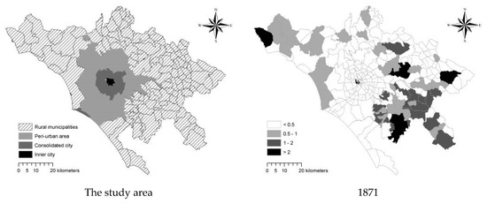
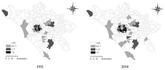
Figure 2.
Spatial distribution of resident population (percent share of population residing in each spatial unit in total population of Rome’s metropolitan area) by year.
Figure 3 outlines the increasing demographic divide in coastal and internal districts of Rome’s metropolitan area. Population size increased continuously between 1871 and 1981, being more stable afterward in coastal districts. Internal districts experienced slow and moderate population increases in 1871–1951 and in 1951–2018, respectively.
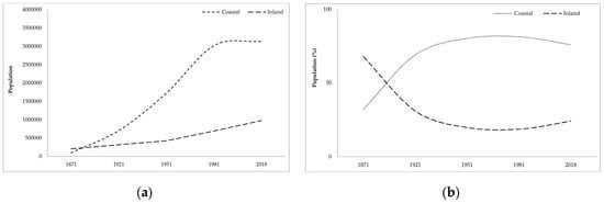
Figure 3.
Total resident population (left) and percent share of the resident population (right) in the total population by district in Rome’s metropolitan area, 1871–2018.
Figure 4 illustrates the most relevant changes over time in population density observed for each spatial unit between 1871 and 2018. The coastal districts in Rome experienced the highest population pressure in the most recent time period. Diachronic maps of population density show the expansion of Rome and the consolidation of residential sub-centers east of Rome between 1871 and 1951. In the early 1950s, the central city occupied the flat area bounded by Rome’s ring road, with density rates systematically higher than 500–1000 inhabitants/km2. In the most recent decades, urban expansion intensified in the coastal districts south and west of Rome. The largest part of the study area was classified at high population density (>500 inhabitants/km2) in 2018 and less than 20 spatial units (out of 236 municipalities and urban districts) host less than 100 inhabitants/km2. A hierarchical clustering (Euclidean distances, Ward’s agglomeration rule) developed with the aim to identify similarities in local-scale population trends along the study period identified two main clusters (1921–1951 and 1961–2018) with one outlier (1871). This partition outlines the spatial coherence of urbanization processes in the aftermath of World War II in Rome, evidencing a more fragmented and spatially heterogeneous developmental path before 1951 (Figure 5).
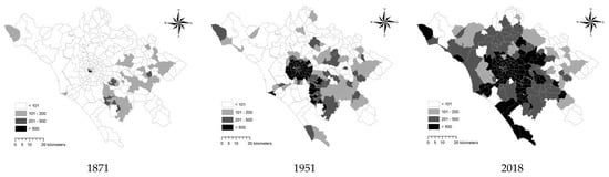
Figure 4.
Demographic density (inhabitants/km2) in Rome’s metropolitan area, 1871–2018.

Figure 5.
Hierarchical clustering (Euclidean distances, Ward’s agglomeration rule) describing similarities in population dynamics over time in Rome’s province.
3.2. Urban Expansion, Land-Use, and Agriculture
The evolution of farms and cropland in Rome (Table 2) was investigated over the last 40 years (1970–2010). In general, the decline in farms and cultivated land was rapid at both the regional and local scales. In Rome’s municipality, total agricultural area declined from 1033 km2 in 1970 to 704 km2 in 2010, and the same trend was observed for the utilized agricultural area (decreasing from 847 km2 in 1970 to 536 km2 in 2010). The number of farms decreased from nearly 5000 units (1970) to 3000 units (2010). The average farm size was rather stable over time in Rome’s municipality (16–17 ha) and slightly lower in the metropolitan area and the administrative region, with a value higher than those recorded in the metropolitan region as a whole (around 5–8 ha). The percent share of utilized agricultural area in total agricultural area, taken as a proxy of crop intensity, decreased in Rome (from 82% to 76%), while increasing moderately in the metropolitan area (from 68% to 71%). These findings reveal a latent process of agricultural intensification at the regional scale and a reverse process of extensivation at the local scale. The percent share of total agricultural area in the total investigated area decreased at both spatial partitions; the highest decline was found in Rome’s metropolitan area (85% in 1970, 47% in 2010). Rome’s municipality destined 46% of total land to agriculture in 2010. This value confirms the importance of cropland as a buffer zone containing urban growth and connecting natural with semi-natural environments.
Table 2.
Selected variables describing the agricultural system in the study area by years, 1970–2010.
Figure 6 illustrates the spatial distribution of the workers in the primary sector in 1951 and 2011 in the study area. Despite urban transformations and important changes in local job markets during the study period, some municipalities and districts maintained a moderate specialization in agriculture along both the coastal area (mainly north of Rome) and the Apennine mountain chain. Figure 7 outlines basic landscape transformations along a relatively long time period (1960–2018). Urban settlements expanded in a mostly chaotic fashion around Rome. Discontinuous-dispersed settlements increased more than compact-dense settlements. Urban expansion led to more fragmented rural landscapes. Landscape homogeneity characterizing rural areas in 1960 (with concentration of garden crop and arable land in lowland and vineyards/olive groves in uplands) was less evident in 2018. Spatial clusters of specialized crop (vineyards and, in part, arable land) disappeared (or reduced strongly) because of discontinuous urban expansion; an example is the huge decline of vineyards in the traditional vine district of ‘Castelli Romani’, south-east of Rome.
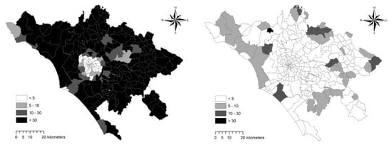
Figure 6.
Percent share of workers in agriculture in total workers, Rome’s metropolitan area (left: 1951; right: 2011).
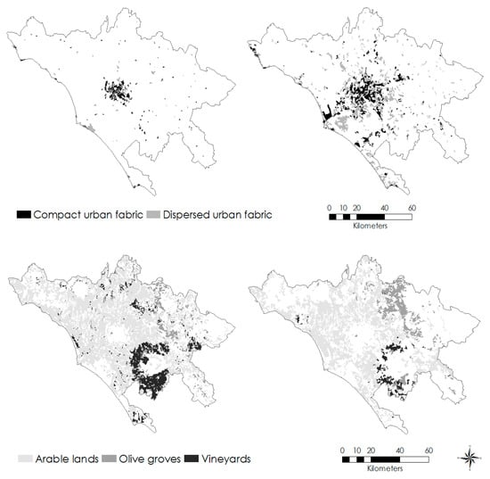
Figure 7.
Long-term land-use changes in the study area (left: 1960; right: 2018).
3.3. An Example of Recent Spatial Dynamics in Coastal Districts
Figure 8 illustrates the basic characteristics of residential settlements in the coastal district of Rome’s municipalities, providing an example of the landscape interface with rural areas. Along the Tyrrhenian Sea coast in Rome’s municipality, settlement morphologies were typically mixed and the physical interface between discontinuous urban fabric and cropland was frequently indistinct. Consolidated medium-density settlements leave big or mid-size plots devoted to agriculture and now abandoned. Management of these urban voids, originally productive and now completely unused, is an increasingly hard task. Recent population dynamics (2006–2018) in 19 coastal districts (bordering the Tyrrhenian Sea) of Rome’s municipality (Figure 9) indicates that the largest expansion of discontinuous settlements was observed in districts where the share of the young population in the total population was the highest. These findings suggest the role of demographic structure by age in local-scale population growth and urban expansion. A young population reflects increasing housing needs and the accelerated demand for infrastructure that leads to further land consumption and cropland abandonment in more accessible flat districts. This process may aliment a downward environmental spiral, driving long-term land take, and a progressive decline of ecosystem services in peri-urban areas.
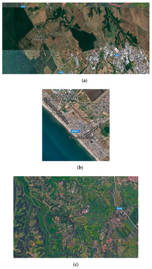

Figure 8.
Aerial photographs illustrating a few examples of peri-urban landscapes in Rome (significant place’s names are included); (a) industrial settlements at the cropland-forest fringe, (b) discontinuous coastal settlements, (c) pre-existing rural settlements in a mixed agricultural landscape, (d) data source: Google Earth imagery (2018).
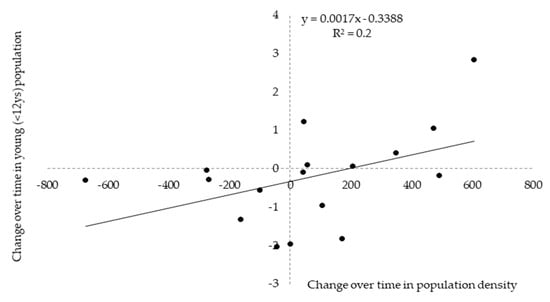
Figure 9.
The relationship between population growth (%, 2006–2018) and the percent share of young population (age < 12 years) in total resident population of 19 coastal districts of Rome’s municipality.
4. Discussion
Going beyond the classical debate on urban cycles and metropolitan growth [2,32,60,61,62], the present study proposed a re-contextualization of long-term development paths in Rome with a focus on the increased population divide between coastal and inland districts and the consequent pressures on rural systems. Being applied to the representative case for the Mediterranean region, an operational approach to complex urban dynamics was proposed as based on a simplified analysis of official statistics, maps, and aerial photographs aimed at providing a knowledge base that informs alternative scenarios for future development of peri-urban districts and agricultural landscapes [63,64,65,66]. Rome’s growth was evaluated along the last 150 years, focusing on population dynamics and the progressive decline of agriculture. The empirical findings of this study indicate coherent trends on a regional and local scale. At the regional level, sequential waves of urbanization (growth of compact-dense settlements) and suburbanization (expansion of low-density, dispersed settlements) altered the spatial distribution of population in distinct (urban and rural) growth poles, alimenting the divide in coastal and inland districts. These processes have impacted the rural system, especially in coastal Rome; the agricultural system typical of the ‘Agro Romano’ was progressively destroyed (or altered significantly), causing the uneven decline of farms and cultivated land [67]. At the same time, the slight recovery observed in 2010 for both farms and the overall size of cultivated land is a positive signal that should be monitored further. As a matter of fact, this landscape preserves one of the most important remnants of the ‘Agro Romano’ directly connected with relict forests, that is, the Castelporziano-Castelfusano-Capocotta estate placed in-between Rome and the Tyrrhenian Sea [16,48,68].
Although spatially continuous and dense urban expansion may sometimes determine negative externalities (e.g., pollution, congestion, scarcity of green spaces), benefits of the ‘compact city’ paradigm have been clearly identified [69]. Compact settlements were recognized as land-saving, causing less impact on traditional landscapes and agricultural systems than dispersed settlements [24,70,71]. With compact and continuous urban expansion, the intimate relationship between inner cities and rural surroundings is regulated by the metropolitan hierarchy organized along the urban gradient [72,73]. This gradient results in a polarized land-use structure and distinct functional roles for urban and rural areas [74,75,76,77,78]. Local-scale population dynamics in the study period preceding World War II in Rome are coherent with these assumptions.
5. Conclusions
Urban diffusion has been demonstrated to drive land-use changes, transforming population density gradients into a sort of ‘metropolitan continuum’, with increasing rates of land take [45]. Recent population dynamics and the consequent processes of cropland abandonment and agricultural fragmentation in Rome are in line with this framework. The empirical results of this study suggest that population decline in downtown Rome and accelerated expansion of sub-centers have stimulated a subtle re-organization of rural spaces, with increasing landscape fragmentation and the partial disappearance of traditional crop. The agricultural traits of such landscapes were progressively lost [79,80]. The negative externalities of dispersed urban expansion include the amplification of urbanization-driven problems (soil sealing, local warming, air and water pollution) and an increased risk of land degradation, drought, and wildfires [81,82]. Similarly to other Mediterranean contexts, these externalities alimented a downward environmental spiral in Rome [83,84] that can be more difficult to contrast if a land planning strategy specific for the study area will be not defined and applied in a sufficiently short time [85,86,87]. Such a strategy should be also coherent with more general policies for sustainable development at the regional and country scale.
It was argued how metropolitan systems reflecting economic polarization and socially divided local communities require strategic interventions that allow a greater level of spatial cohesion, economic competitiveness, and environmental sustainability [88]. The results of the present study suggest that an unbalanced population distribution over space determines a local context more prone to land consumption and agricultural abandonment in Mediterranean environments [88,89].
Measures of sustainable urban development should promote the concentration of residential settlement along already developed spatial directions and in local contexts with low-quality soils [90], preventing the uncontrolled expansion of residential/service settlements in fertile buffer zones with agricultural and natural ecosystems [91]. In these regards, the integral conservation of traditional agricultural systems is a particularly important task of policies enhancing economic viability and touristic attractiveness of buffer zones around large- and medium-size cities [92].
Author Contributions
Conceptualization, L.S. and R.H.-C.-Z.; methodology, S.C.; software, G.E.; validation, A.C., formal analysis, A.C.; investigation, S.C. and G.Q.; resources, G.Q.; data curation, G.E.; writing—original draft preparation, L.S. and G.Q.; writing—review and editing, R.H.-C.-Z. and A.C.; visualization, S.C.; supervision, G.E.; project administration, G.Q.; funding acquisition, R.H.-C.-Z. All authors have read and agreed to the published version of the manuscript.
Conflicts of Interest
The authors declare no conflict of interest.
References
- Nüssli, R.; Schmid, C. Beyond the urban–suburban divide: Urbanization and the production of the urban in Zurich North. Int. J. Urban Reg. Res. 2016, 40, 679–701. [Google Scholar] [CrossRef]
- Van Den Berg, L.; Drewett, L.; Klaassen, L.H. Urban. Europe: A Study of Growth and Decline; Pergamon Press: Oxford, UK, 1982. [Google Scholar]
- Leontidou, L. The Mediterranean City in Transition; Cambridge University Press: Cambridge, UK, 1990. [Google Scholar]
- Couch, C.; Petschel-Held, G.; Leontidou, L. Urban Sprawl in Europe: Landscapes, Land-Use Change and Policy; Blackwell: Oxford, UK, 2007. [Google Scholar]
- Moroni, S.; Minola, L. Unnatural sprawl: Reconsidering public responsibility for suburban development in Italy, and the desirability and possibility of changing the rules of the game. Land Use Policy 2019, 86, 104–112. [Google Scholar] [CrossRef]
- Morote, Á.F.; Hernández, M. Urban sprawl and its effects on water demand: A case study of Alicante, Spain. Land Use Policy 2016, 50, 352–362. [Google Scholar] [CrossRef]
- Hervieu, B.; Thibault, H.L. Repenser le Développement Rural en Méditerranée; Rapport Mediterra; CIHEAM-IAMB: Bari, Italy, 2009; p. 403. [Google Scholar]
- European Environment Agency. Landscape Fragmentation in Europe; EEA: Copenhagen, Denmark, 2011. [Google Scholar]
- UNEP/MAP (Mediterranean Action Plan). State of the Mediterranean Marine and Coastal Environment; UNEP/MAP: Athens, Greece, 2012. [Google Scholar]
- Elmqvist, T.; Fragkias, M.; Goodness, J.; Güneralp, B.; Marcotullio, P.J.; McDonald, R.I.; Parnell, S.; Schewenius, M.; Sendstad, M.; Seto, K.C.; et al. Urbanization, Biodiversity and Ecosystem Services: Challenges and Opportunities; Springer: Utrecht, The Netherlands, 2013. [Google Scholar]
- Gosnell, H.; Abrams, J. Amenity migration: Diverse conceptualizations of drivers, socioeconomic dimensions, and emerging challenges. GeoJournal 2011, 76, 303–322. [Google Scholar] [CrossRef]
- Krueger, R.; Gibbs, D.; Carr, C. Examining regional competitiveness and the pressures of rapid growth: An interpretive institutionalist account of policy responses in three city regions. Environ. Plan. C Polit. Space 2018, 36, 965–986. [Google Scholar] [CrossRef]
- Muñoz, F. Lock living: Urban sprawl in Mediterranean cities. Cities 2003, 20, 381–385. [Google Scholar] [CrossRef]
- Catalàn, B.; Sauri, D.; Serra, P. Urban sprawl in the Mediterranean? Patterns of growth and change in the Barcelona Metropolitan Region 1993–2000. Landsc. Urban Plan. 2008, 85, 174–184. [Google Scholar]
- Terzi, F.; Bolen, F. Urban sprawl measurement of Istanbul. Eur. Plan. Stud. 2009, 17, 1559–1570. [Google Scholar] [CrossRef]
- Munafò, M.; Salvati, L.; Zitti, M. Estimating soil sealing rate at national level—Italy as a case study. Ecol. Indic. 2013, 26, 137–140. [Google Scholar]
- Arribas-Bel, D.; Nijkamp, P.; Scholten, H. Multidimensional urban sprawl in Europe: A self-organizing map approach. Comput. Environ. Urban Syst. 2011, 35, 263–275. [Google Scholar] [CrossRef]
- Barbero-Sierra, C.; Marques, M.J.; Ruíz-Pérez, M. The case of urban sprawl in Spain as an active and irreversible driving force for desertification. J. Arid Environ. 2013, 90, 95–102. [Google Scholar] [CrossRef]
- Bruegmann, R. Sprawl: A Compact History; University of Chicago Press: Chicago, IL, USA, 2005. [Google Scholar]
- Garcia, X.; Ribas, A.; Llausàs, A.; Saurí, D. Socio-demographic profiles in suburban developments: Implications for water-related attitudes and behaviors along the Mediterranean coast. Appl. Geogr. 2013, 41, 46–54. [Google Scholar] [CrossRef]
- Carlucci, M.; Grigoriadis, E.; Rontos, K.; Salvati, L. Revisiting a hegemonic concept: Long-term ‘Mediterranean urbanization’in between city re-polarization and metropolitan decline. Appl. Spat. Anal. Policy 2017, 10, 347–362. [Google Scholar] [CrossRef]
- Longhi, C.; Musolesi, A. European cities in the process of economic integration: Towards structural convergence. Ann. Reg. Sci. 2007, 41, 333–351. [Google Scholar] [CrossRef]
- Turok, I.; Mykhnenko, V. The trajectories of European cities, 1960–2005. Cities 2007, 24, 165–182. [Google Scholar] [CrossRef]
- Schneider, A.; Woodcock, C.E. Compact, dispersed, fragmented, extensive? A comparison of urban growth in twenty-five global cities using remotely sensed data, pattern metrics and census information. Urban Stud. 2008, 45, 659–692. [Google Scholar] [CrossRef]
- McDonnell, M.J.; Hahs, A.K. The use of gradient analysis studies in advancing our understanding of the ecology of urbanizing landscapes: Current status and future directions. Landsc. Ecol. 2008, 23, 1143–1155. [Google Scholar] [CrossRef]
- Modica, G.; Vizzari, M.; Pollino, M.; Fichera, C.R.; Zoccali, P.; Di Fazio, S. Spatio-temporal analysis of the urban–rural gradient structure: An application in a Mediterranean mountainous landscape. Earth Syst. Dyn. 2012, 3, 263–279. [Google Scholar] [CrossRef]
- Camagni, R.; Capello, R.; Nijkamp, P. Toward Sustainable City Policy: An Economy-Environment-Technology Nexus. Ecol. Econ. 1998, 24, 103–118. [Google Scholar] [CrossRef]
- Garcia-López, M.À. Population suburbanization in Barcelona, 1991–2005: Is its spatial structure changing? J. Hous. Econ. 2010, 19, 119–132. [Google Scholar] [CrossRef]
- Aguilar, A.G. Peri-urbanization, illegal settlements and environmental impact in Mexico City. Cities 2008, 25, 133–145. [Google Scholar] [CrossRef]
- Cavallo, A.; Di Donato, B.; Marino, D. Mapping and assessing urban agriculture in Rome. Agric. Agric. Sci. Procedia 2016, 8, 744–783. [Google Scholar] [CrossRef]
- Phelps, N.A. Suburbs for nations? Some interdisciplinary connections on the suburban economy. Cities 2010, 27, 68–76. [Google Scholar] [CrossRef]
- Morelli, G.V.; Rontos, K.; Salvati, L. Between suburbanisation and re-urbanisation? Revisiting the Urban Life Cycle in a Mediterranean Compact City. Urban Res. Pract. 2014, 7, 74–88. [Google Scholar] [CrossRef]
- Alphan, H. Land use change and urbanisation of Adana, Turkey. Land Degrad. Dev. 2003, 14, 575–586. [Google Scholar] [CrossRef]
- Nijkamp, P.; Kourtit, K. The “new urban Europe”: Global challenges and local responses in the urban century. Eur. Plan. Stud. 2013, 21, 291–315. [Google Scholar] [CrossRef]
- Prishchepov, A.V.; Müller, D.; Dubinin, M.; Baumann, M.; Radeloff, V.C. Determinants of agricultural land abandonment in post-Soviet European Russia. Land Use Policy 2013, 30, 873–884. [Google Scholar] [CrossRef]
- Serra, P.; Vera, A.; Tulla, A.F.; Salvati, L. Beyond urban–rural dichotomy: Exploring socioeconomic and land-use processes of change in Spain (1991–2011). Appl. Geogr. 2014, 55, 71–81. [Google Scholar] [CrossRef]
- Rontos, K.; Grigoriadis, E.; Sateriano, A.; Syrmali, M.; Vavouras, I.; Salvati, L. Lost in protest, found in segregation: Divided cities in the light of the 2015 “Oχι” referendum in Greece. City Cult. Soc. 2016, 7, 139–148. [Google Scholar] [CrossRef]
- Salvati, L.; Serra, P. Estimating rapidity of change in complex urban systems: A multidimensional, local-scale approach. Geogr. Anal. 2016, 48, 132–156. [Google Scholar] [CrossRef]
- Zambon, I.; Serra, P.; Sauri, D.; Carlucci, M.; Salvati, L. Beyond the ‘Mediterranean city’: Socioeconomic disparities and urban sprawl in three Southern European cities. Geogr. Ann. Ser. B Hum. Geogr. 2017, 99, 319–337. [Google Scholar] [CrossRef]
- Parés, M.; March, H.; Saurí, D. Atlantic gardens in Mediterranean climates: Understanding the production of suburban natures in Barcelona. Int. J. Urban Reg. Res. 2013, 37, 328–347. [Google Scholar] [CrossRef]
- Vaz, E.; Nijkamp, P. Gravitational forces in the spatial impacts of urban sprawl: An investigation of the region of Veneto, Italy. Habitat Int. 2015, 45, 99–105. [Google Scholar] [CrossRef]
- Wehrwein, G.S. The rural-urban fringe. Econ. Geogr. 1942, 18, 217–228. [Google Scholar] [CrossRef]
- Costa, F. Urban planning in Rome from 1870 to the first world war. GeoJournal 1991, 24, 269–276. [Google Scholar] [CrossRef]
- Krumholz, N. Roman impressions: Contemporary city planning and housing in Rome. Landsc. Urban Plan. 1992, 22, 107–114. [Google Scholar] [CrossRef]
- De Muro, P.; Monni, S.; Tridico, P. Knowledge-Based Economy and Social Exclusion: Shadow and Light in the Roman Socio-Economic Model. Int. J. Urban Reg. Res. 2011, 35, 1212–1238. [Google Scholar] [CrossRef]
- Shearmur, R. Are cities the font of innovation? A critical review of the literature on cities and innovation. Cities 2012, 29, S9–S18. [Google Scholar] [CrossRef]
- Phelps, N.A.; Parsons, N.; Ballas, D.; Dowling, A. Post-Suburban Europe: Planning and Politics at the Margins of Europe’s Capital Cities; Palgrave Macmillan: Basingstoke, UK, 2006. [Google Scholar]
- Biasi, R.; Colantoni, A.; Ferrara, C.; Ranalli, F.; Salvati, L. In-between sprawl and fires: Long-term forest expansion and settlement dynamics at the wildland–urban interface in Rome, Italy. Int. J. Sustain. Dev. World Ecol. 2015, 22, 467–475. [Google Scholar] [CrossRef]
- Colantoni, A.; Grigoriadis, E.; Sateriano, A.; Venanzoni, G.; Salvati, L. Cities as selective land predators? A lesson on urban growth, deregulated planning and sprawl containment. Sci. Total Environ. 2016, 545, 329–339. [Google Scholar] [CrossRef]
- Cuadrado-Ciuraneta, S.; Durà-Guimerà, A.; Salvati, L. Not only tourism: Unravelling suburbanization, second-home expansion and “rural” sprawl in Catalonia, Spain. Urban Geogr. 2017, 38, 66–89. [Google Scholar] [CrossRef]
- Rauhut, D. Polycentricity–one concept or many? Eur. Plan. Stud. 2017, 25, 332–348. [Google Scholar] [CrossRef]
- Schmitt, P. Planning for polycentricity in European metropolitan areas—Challenges, expectations and practices. Plan. Pract. Res. 2013, 28, 400–419. [Google Scholar] [CrossRef]
- Veneri, P.; Burgalassi, D. Questioning polycentric development and its effects. Issues of definition and measurement for the Italian NUTS-2 regions. Eur. Plan. Stud. 2012, 20, 1017–1037. [Google Scholar] [CrossRef]
- Salvati, L.; Carlucci, M. A composite index of sustainable development at the local scale: Italy as a case study. Ecol. Indic. 2014, 43, 162–171. [Google Scholar] [CrossRef]
- Duvernoy, I.; Zambon, I.; Sateriano, A.; Salvati, L. Pictures from the other side of the fringe: Urban growth and peri-urban agriculture in a post-industrial city (Toulouse, France). J. Rural Stud. 2018, 57, 25–35. [Google Scholar] [CrossRef]
- Gonzales, S. The north/south divide in Italy and England: Discursive construction of regional inequality. Eur. Urban Reg. Stud. 2011, 18, 62–76. [Google Scholar] [CrossRef]
- Haase, D.; Nuissl, H. The urban-to-rural gradient of land use change and impervious cover: A long-term trajectory for the city of Leipzig. Land Use Sci. 2010, 5, 123–142. [Google Scholar] [CrossRef]
- Kasanko, M.; Barredo, J.I.; Lavalle, C.; McCormick, N.; Demicheli, L.; Sagris, V.; Brezger, A. Are European Cities Becoming Dispersed? A Comparative Analysis of Fifteen European Urban Areas. Landsc. Urban Plan. 2006, 77, 111–130. [Google Scholar] [CrossRef]
- Salvati, L.; Zambon, I.; Pignatti, G.; Colantoni, A.; Cividino, S.; Perini, L.; Cecchini, M.A. Time-Series Analysis of Climate Variability in Urban and Agricultural Sites (Rome, Italy). Agriculture 2019, 9, 103. [Google Scholar] [CrossRef]
- Berry, B.J.L. Urbanization and Counterurbanization; Sage: New York, NY, USA, 1976. [Google Scholar]
- Zambon, I.; Colantoni, A.; Salvati, L. Horizontal vs vertical growth: Understanding latent patterns of urban expansion in large metropolitan regions. Sci. Total Environ. 2019, 654, 778–785. [Google Scholar] [CrossRef] [PubMed]
- Martinez-Fernandez, C.; Audirac, I.; Fol, S. Cunningham-Sabot, E. Shrinking cities: Urban challenges of globalization. Int. J. Urban Reg. Res. 2012, 36, 213–225. [Google Scholar] [CrossRef] [PubMed]
- Aretano, R.; Petrosillo, I.; Zaccarelli, N.; Semeraro, T.; Zurlini, G. People perception of landscape change effects on ecosystem services in small Mediterranean islands: A combination of subjective and objective assessments. Landsc. Urban Plan. 2013, 112, 63–73. [Google Scholar] [CrossRef]
- Dura-Guimera, A. Population deconcentration and social restructuring in Barcelona, a European Mediterranean city. Cities 2003, 20, 387–394. [Google Scholar] [CrossRef]
- Delladetsima, P.M. The emerging property development pattern in Greece and its impact on spatial development. Eur. Urban Reg. Stud. 2006, 13, 245–278. [Google Scholar] [CrossRef]
- European Environment Agency. Urban Sprawl in Europe—The Ignored Challenge; EEA Report no. 10; EEA: Copenhagen, Denmark, 2006. [Google Scholar]
- Salvati, L.; Perini, L.; Sabbi, A.; Bajocco, S. Climate Aridity and Land Use Changes: A Regional-Scale Analysis. Geogr. Res. 2012, 50, 193–203. [Google Scholar] [CrossRef]
- Colantoni, A.; Mavrakis, A.; Sorgi, T.; Salvati, L. Towards a ‘polycentric’ landscape? Reconnecting fragments into an integrated network of coastal forests in Rome. Rend. Lincei 2015, 26, 615–624. [Google Scholar] [CrossRef]
- Gkartzios, M.; Scott, M. Countering counter-urbanisation: Spatial planning challenges in a dispersed city-region, the greater Dublin area. Town Plan. Rev. 2017, 81, 23–52. [Google Scholar] [CrossRef]
- Dierwechter, Y. Metropolitan geographies of US climate action: Cities, suburbs, and the local divide in global responsibilities. J. Environ. Policy Plan. 2010, 12, 59–82. [Google Scholar] [CrossRef]
- Ewing, R. Is Los Angeles-style sprawl desirable? J. Am. Plan. Assoc. 1997, 63, 107–126. [Google Scholar] [CrossRef]
- Robinson, J. Cities in a world of cities: The comparative gesture. Int. J. Urban Reg. Res. 2017, 35, 1–23. [Google Scholar] [CrossRef]
- Scott, A.J.; Storper, M. The nature of cities: The scope and limits of urban theory. Int. J. Urban Reg. Res. 2015, 39, 1–15. [Google Scholar] [CrossRef]
- Zitti, M.; Ferrara, C.; Perini, L.; Carlucci, M.; Salvati, L. Long-term urban growth and land use efficiency in Southern Europe: Implications for sustainable land management. Sustainability 2015, 7, 3359–3385. [Google Scholar] [CrossRef]
- Tomao, A.; Quatrini, V.; Corona, P.; Ferrara, A.; Lafortezza, R.; Salvati, L. Resilient landscapes in Mediterranean urban areas: Understanding factors influencing forest trends. Environ. Res. 2017, 156, 1–9. [Google Scholar] [CrossRef] [PubMed]
- Salvati, L.; Zambon, I.; Chelli, F.M.; Serra, P. Do spatial patterns of urbanization and land consumption reflect different socioeconomic contexts in Europe? Sci. Total Environ. 2018, 625, 722–730. [Google Scholar] [CrossRef]
- Frenkel, A.; Ashkenazi, M. The integrated sprawl index: Measuring the urban landscape in Israel. Ann. Reg. Sci. 2007, 42, 99–121. [Google Scholar] [CrossRef]
- Frenkel, A.; Ashkenazi, M. Measuring Urban Sprawl: How can We Deal with It? Environ. Plan. B 2008, 35, 56–79. [Google Scholar] [CrossRef]
- Cecchini, M.; Zambon, I.; Pontrandolfi, A.; Turco, R.; Colantoni, A.; Mavrakis, A.; Salvati, L. Urban sprawl and the ‘olive’ landscape: Sustainable land management for ‘crisis’ cities. GeoJournal 2019, 84, 237–255. [Google Scholar] [CrossRef]
- Zasada, I.; Loibl, W.; Köstl, M.; Piorr, A. Agriculture under human influence: A spatial analysis of farming systems and land use in European rural-urban-regions. Eur. Countrys. 2013, 5, 71–88. [Google Scholar] [CrossRef]
- Seto, K.C.; Sánchez-Rodríguez, R.; Fragkias, M. The new geography of contemporary urbanization and the environment. Annu. Rev. Environ. Resour. 2010, 35, 167–194. [Google Scholar] [CrossRef]
- Sevilla-Buitrago, A. Debating contemporary urban conflicts: A survey of selected scholars. Cities 2013, 31, 454–468. [Google Scholar] [CrossRef]
- Bajocco, S.; Ceccarelli, T.; Smiraglia, D.; Salvati, L.; Ricotta, C. Modeling the ecological niche of long-term land use changes: The role of biophysical factors. Ecol. Indic. 2016, 60, 231–236. [Google Scholar] [CrossRef]
- Bajocco, S.; De Angelis, A.; Salvati, L. A satellite-based green index as a proxy for vegetation cover quality in a Mediterranean region. Ecol. Indic. 2012, 23, 578–587. [Google Scholar] [CrossRef]
- Ferrara, A.; Salvati, L.; Sabbi, A.; Colantoni, A. Soil resources, land cover changes and rural areas: Towards a spatial mismatch? Sci. Total Environ. 2014, 478, 116–122. [Google Scholar] [CrossRef]
- Di Feliciantonio, C.; Salvati, L. ‘Southern’ Alternatives of Urban Diffusion: Investigating Settlement Characteristics and Socio-Economic Patterns in Three Mediterranean Regions. Tijdschrift Voor Economische En Sociale Geografie 2015, 106, 453–470. [Google Scholar] [CrossRef]
- De Rosa, S.; Salvati, L. Beyond a ‘side street story’? Naples from spontaneous centrality to entropic polycentricism, towards a ‘crisis city’. Cities 2016, 51, 74–83. [Google Scholar] [CrossRef]
- Galster, G.; Hanson, R.; Ratcliffe, M.R.; Wolman, H.; Coleman, S.; Freihage, J. Wrestling sprawl to the ground: Defining and measuring an elusive concept. Hous. Policy Debate 2001, 12, 681–717. [Google Scholar] [CrossRef]
- Chorianopoulos, I.; Pagonis, T.; Koukoulas, S.; Drymoniti, S. Planning, competitiveness and sprawl in the Mediterranean city: The case of Athens. Cities 2010, 27, 249–259. [Google Scholar] [CrossRef]
- Salvia, R.; Serra, P.; Zambon, I.; Cecchini, M.; Salvati, L. In-Between Sprawl and Neo-Rurality: Sparse Settlements and the Evolution of Socio-Demographic Local Context in a Mediterranean Region. Sustainability 2018, 10, 3670. [Google Scholar] [CrossRef]
- Zambon, I.; Benedetti, A.; Ferrara, C.; Salvati, L. Soil matters? A multivariate analysis of socioeconomic constraints to urban expansion in Mediterranean Europe. Ecol. Econ. 2018, 146, 173–183. [Google Scholar] [CrossRef]
- Pili, S.; Grigoriadis, E.; Carlucci, M.; Clemente, M.; Salvati, L. Towards sustainable growth? A multi-criteria assessment of (changing) urban forms. Ecol. Indic. 2017, 76, 71–80. [Google Scholar] [CrossRef]


© 2020 by the authors. Licensee MDPI, Basel, Switzerland. This article is an open access article distributed under the terms and conditions of the Creative Commons Attribution (CC BY) license (http://creativecommons.org/licenses/by/4.0/).