Santiago de Chile through the Eyes of Jane Jacobs. Analysis of the Conditions for Urban Vitality in a Latin American Metropolis

 , ,
, ,
Abstract
:1. Introduction
2. Jane Jacobs’ Vision of the Conditions for Urban Vitality
3. Methodology
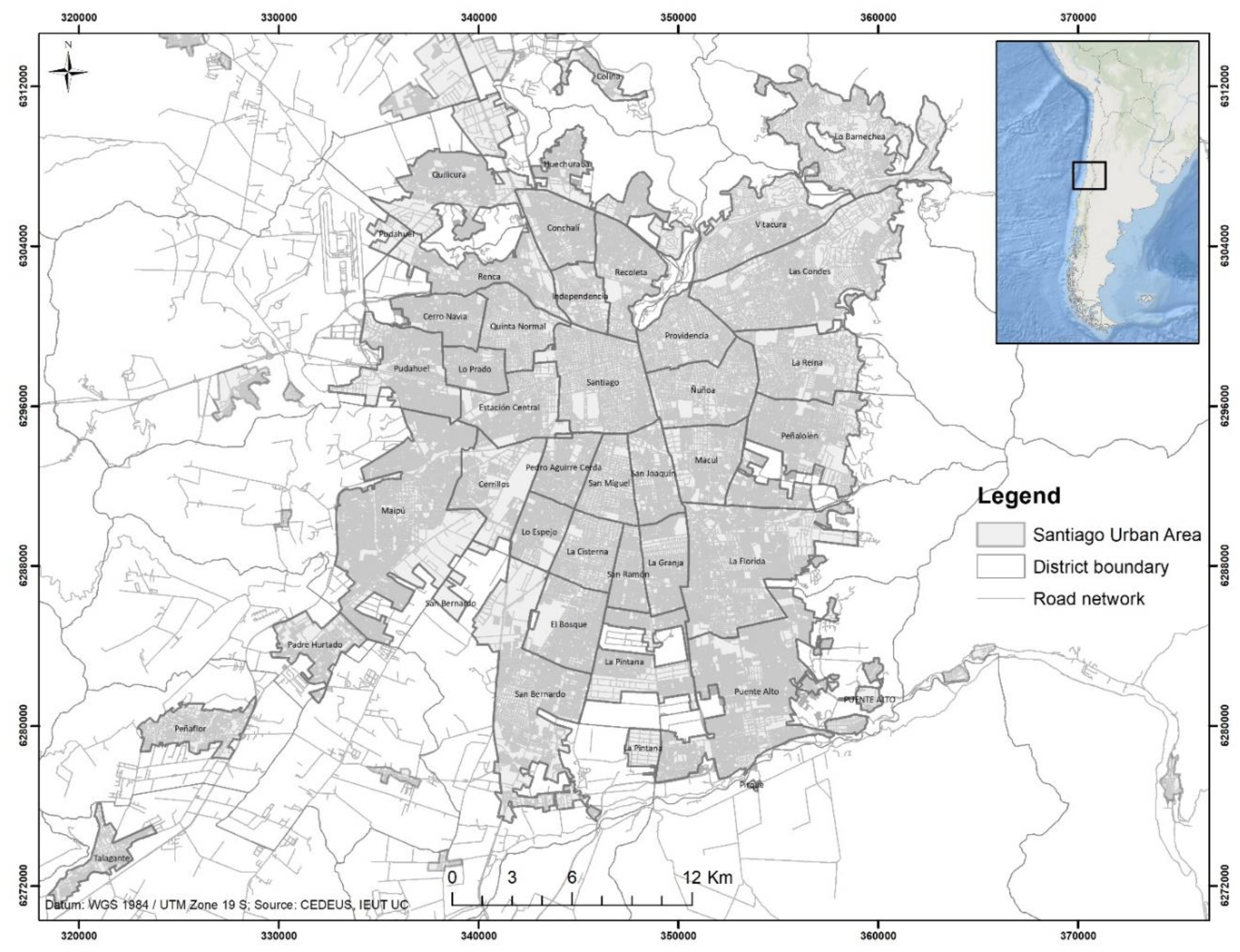
3.1. Study Area
3.2. Calculation of the Dimensions of Urban Vitality
3.2.1. Concentration Score (CS)
3.2.2. Diversity Score (DS)
3.2.3. Contact Opportunity Score (COS)
3.2.4. Need for Aged Buildings Score (NABS)
3.2.5. Accessibility Score (AS)
3.2.6. Distance to Border Vacuums Score (DBVS)
3.2.7. Jane Index
4. Results
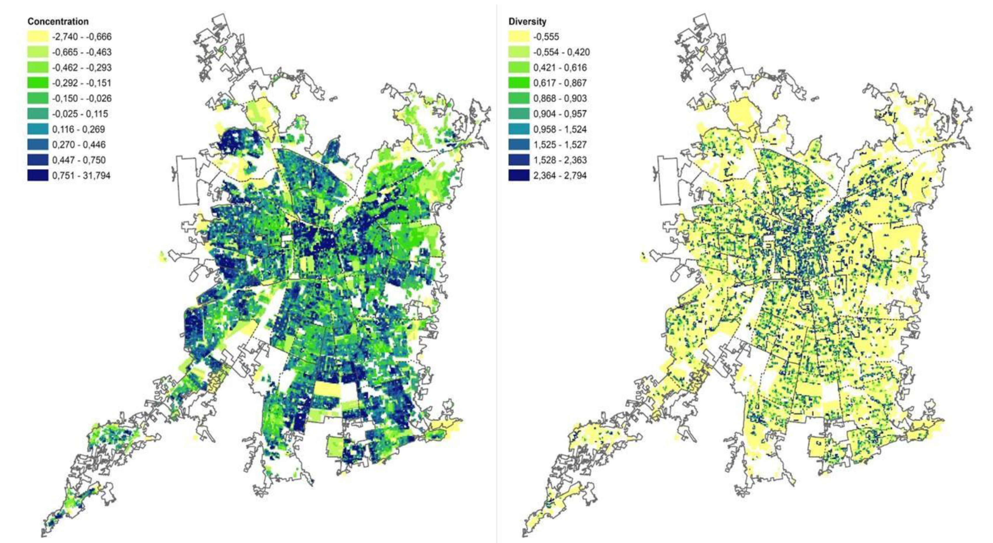
4.1. Concentration
4.2. Diversity of Uses
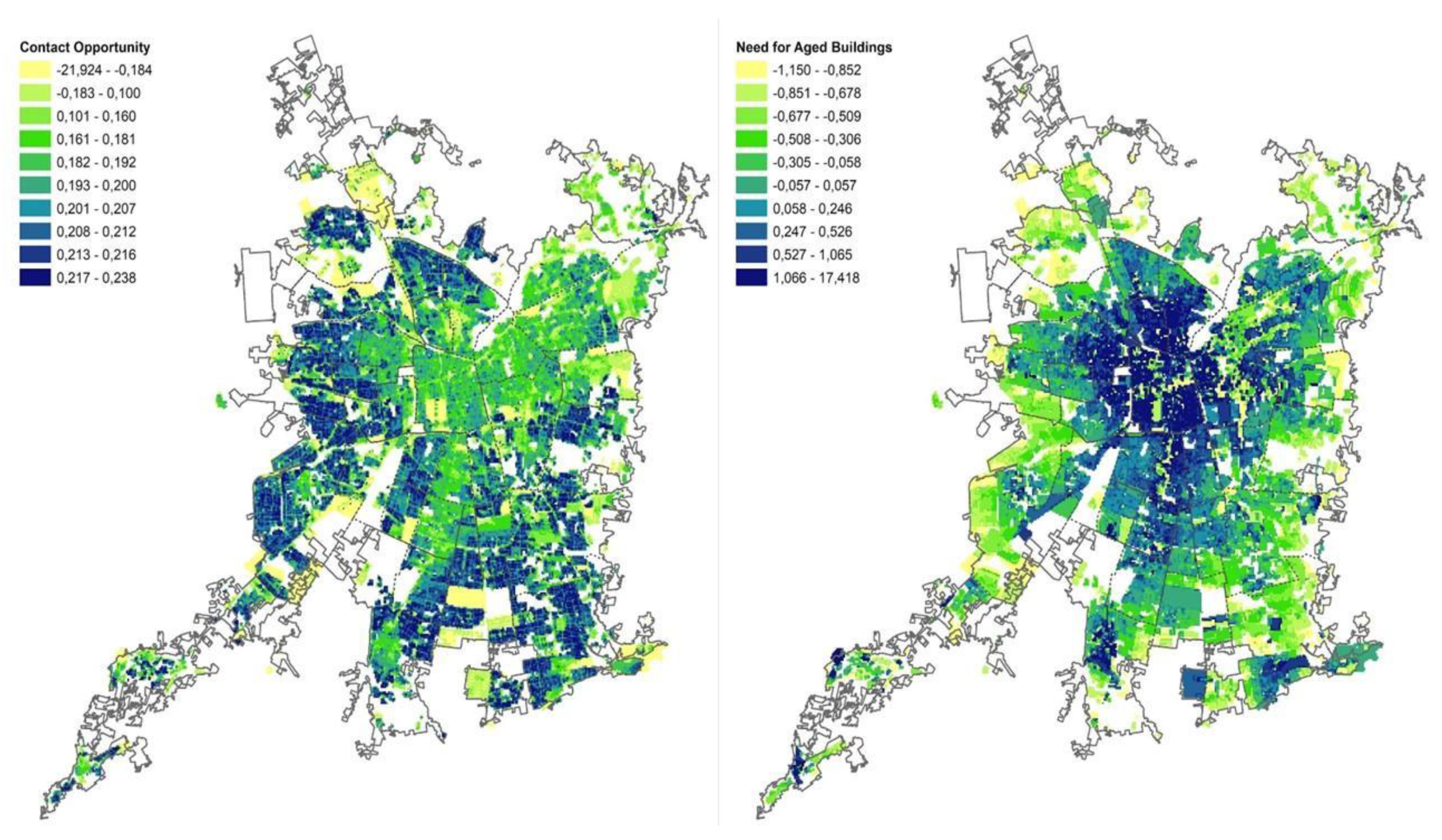
4.3. Contact Opportunity
4.4. Need for Aged Buildings
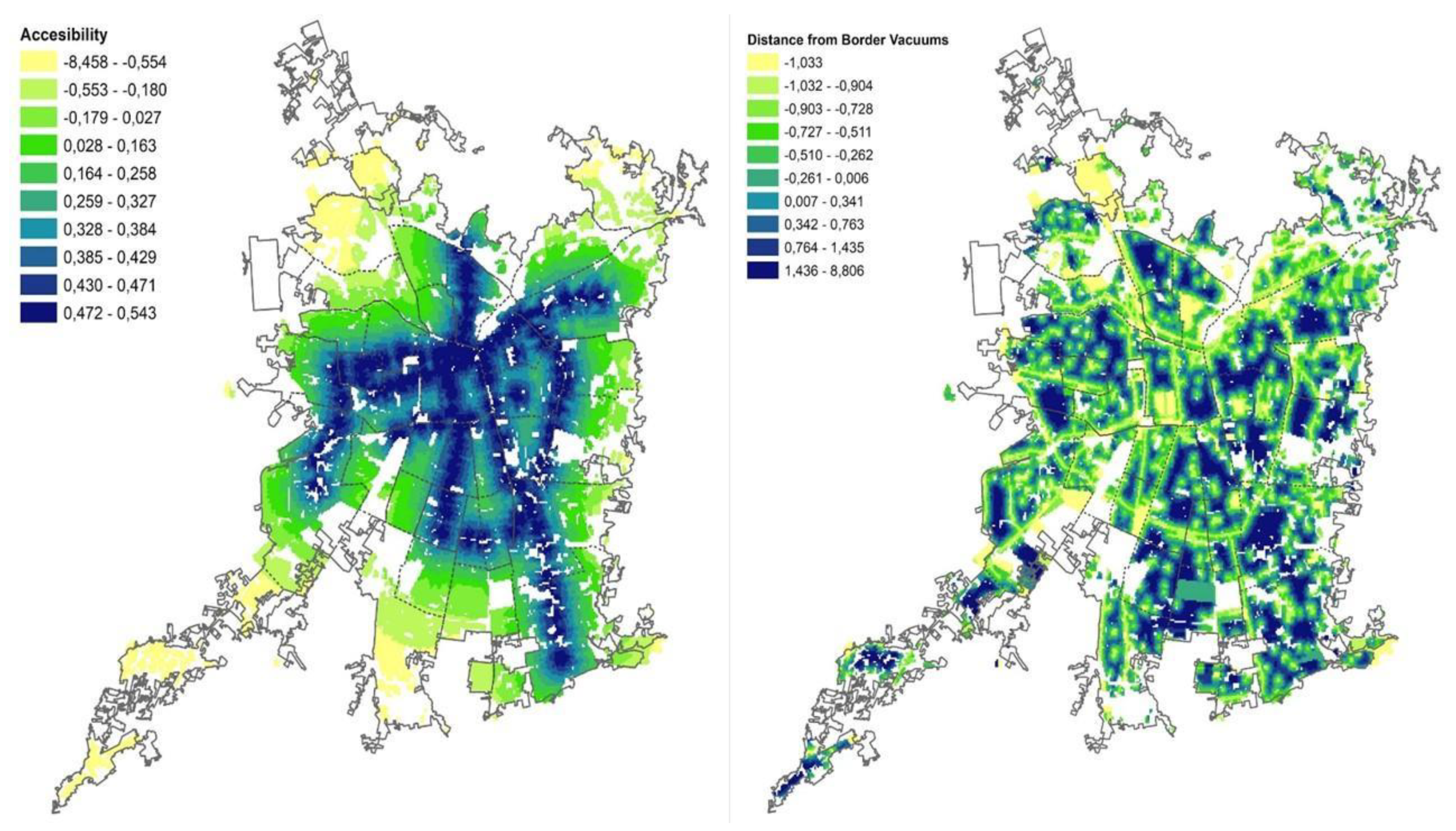
4.5. Accessibility
4.6. Distance to Border Vacuums
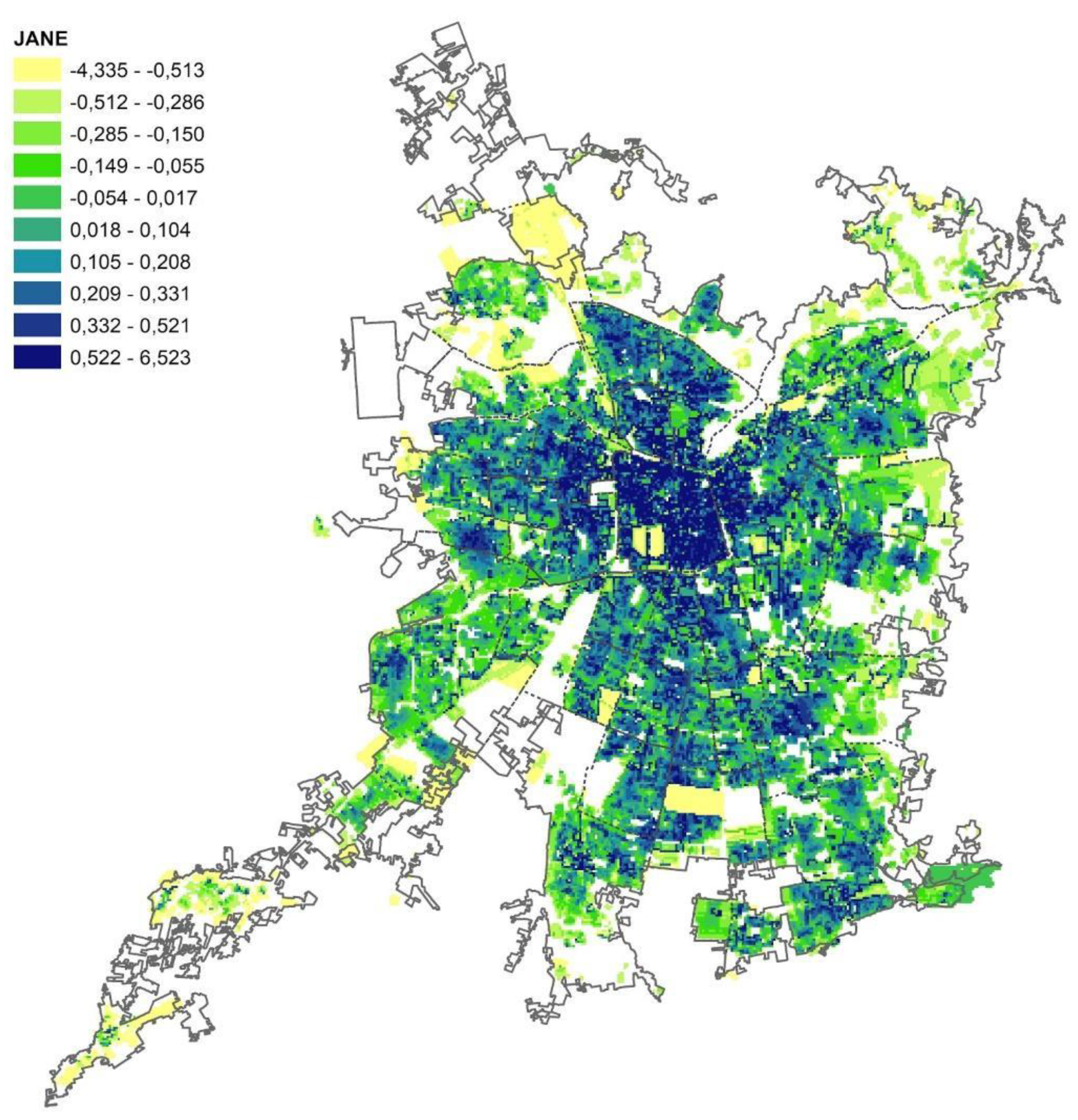
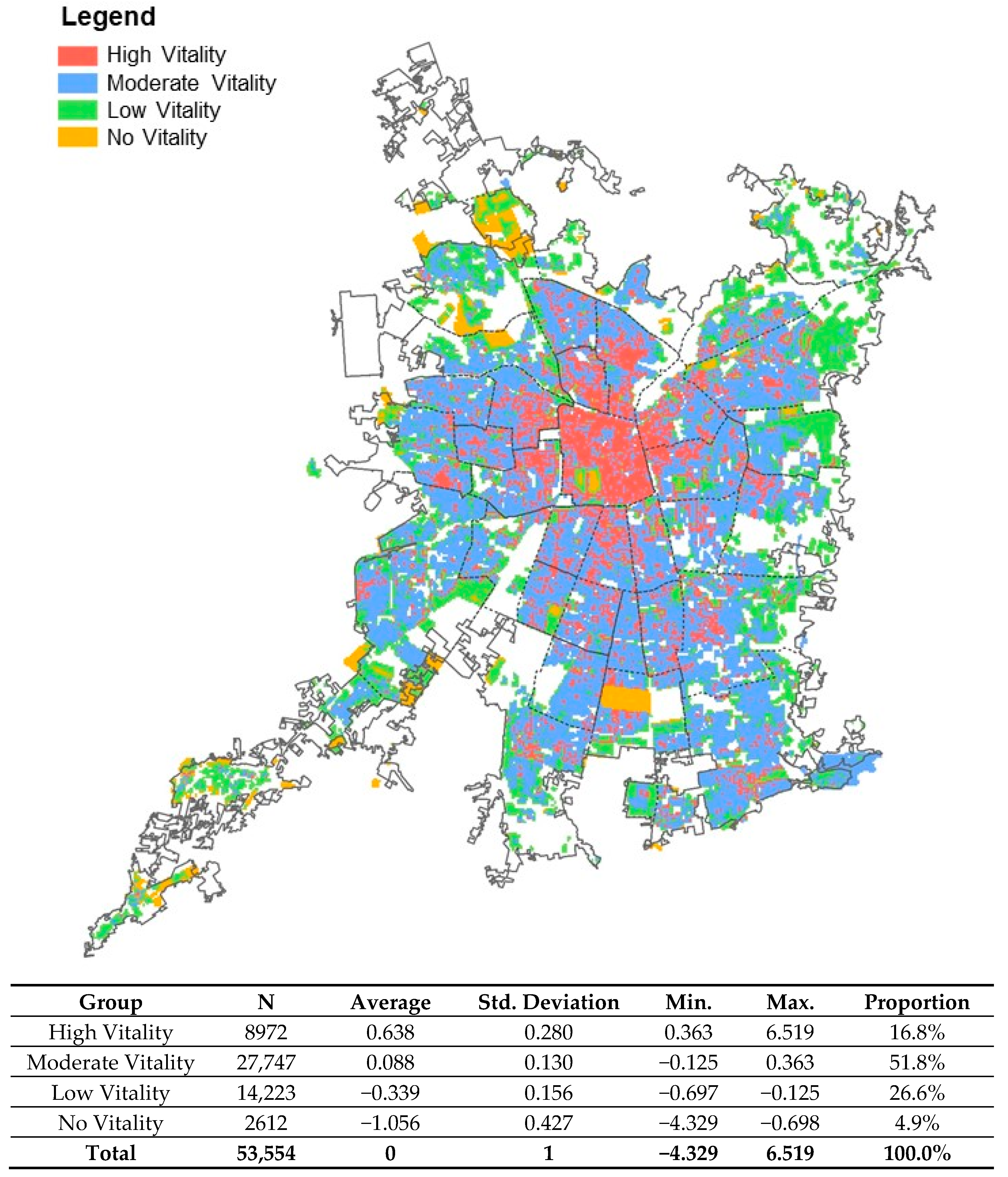
4.7. Index of Urban Vitality for Santiago
5. Discussion and Conclusions
Author Contributions
Funding
Conflicts of Interest
References
- Delclòs-Alió, X.; Miralles-Guasch, C. Looking at Barcelona throug Jane Jacobs’s eyes: Mapping the basic conditions for urban vitality in a Mediterranean conurbation. Land Use Policy 2018, 75, 505–517. [Google Scholar] [CrossRef]
- Page, M. Introducción: Más de lo que se ve. In Reconsiderando a Jane Jacobs; Page, M., Mennel, T., Eds.; Asociación Americana de Planificación: Chicago, IL, USA, 2011; pp. 3–14. [Google Scholar]
- Jacobs, J. The Death and Life of Great American Cities, 1st ed.; Vintage Books: New York, NY, USA, 1961. [Google Scholar]
- Daniere, A. Canadian Urbanism and Jane Jacobs. J. Urban Aff. 2000, 4, 459–461. [Google Scholar] [CrossRef]
- Blokland, T.; Nast, J. From Public Familiarity to Comfort Zone: The Relevance of Absent Ties for Belonging in Berlin’s Mixed Neighbourhoods. Int. J. Urban Reg. Res. 2014, 38, 1142–1159. [Google Scholar] [CrossRef]
- Delclòs-Alió, X.; Gutiérrez, A.; Miralles-Guash, C. The urban vitality conditions of Jane Jacobs in Barcelona: Residential and smartphone-based tracking measurements of the built environment in a Mediterranean metropolis. Cities 2018, 86, 220–228. [Google Scholar] [CrossRef]
- Hoogerbrugge, M.; Burger, M. Neighborhood-Based social capital and life satisfaction: The case of Rotterdam, The Netherlands. Urban Geogr. 2018, 39, 2–27. [Google Scholar] [CrossRef] [Green Version]
- Kearns, A.; Forrest, R. Social Cohesion and Multilevel Urban Governance. Urban Stud. 2000, 37, 995–1017. [Google Scholar] [CrossRef]
- Middleton, J. The Socialities of Everyday Urban Walking and the ‘Right to the City. Urban Stud. 2018, 55, 296–315. [Google Scholar] [CrossRef]
- Mollenhorst, G. Neighbour Relations in the Netherlands: New Developments. Tijdschr. Econ. Soc. Geogr. 2015, 106, 110–119. [Google Scholar] [CrossRef]
- Montgomery, J. Making a City: Urbanity, Vitality and Urban Design. J. Urban Des. 1998, 3, 93–116. [Google Scholar] [CrossRef]
- Talen, E. Sense of Community and Neighbourhood Form: An Assessment of the Social Doctrine of New Urbanism. Urban Stud. 1999, 36, 1361–1379. [Google Scholar] [CrossRef]
- Kang, C.; Fan, D.; Jiao, H. Validating activity, time, and space diversity as essential components of urban vitality. Environ. Plan. B-Urban Anal. City Sci. 2020. [Google Scholar] [CrossRef]
- Bonaiuto, M.; Fornara, F.; Ariccio, S.; Ganucci, U.; Rahimi, L. Perceived residential environment quality indicators (PREQIs) relevance for UN-HABITAT city prosperity index (CPI). Habitat Int. 2014, 45, 53–63. [Google Scholar] [CrossRef]
- Casakin, H.; Hernandez, B.; Ruiz, C. Place attachment and place identity in Israeli cities: The influence of city size. Cities 2014, 42, 224–230. [Google Scholar] [CrossRef]
- Hu, F.; Liu, W.; Lu, J.Y.; Song, C.P.; Meng, Y.; Wang, J.; Xing, H.F. Urban Function as a New Perspective for Adaptive Street Quality Assessment. Sustainability 2020, 12, 1296. [Google Scholar] [CrossRef] [Green Version]
- Scannell, L.; Gifford, R. Defining Place Attachment: A Tripartite Organizing Framework. J. Environ. Psychol. 2010, 30, 1–10. [Google Scholar] [CrossRef]
- Méndez, M.; Otero, G.; Link, F.; López, E.; Gayo, M. Neighbourhood cohesion as a form of privilege. Urban Stud. 2020, 1–21. [Google Scholar] [CrossRef]
- De Mattos, C.; Fuentes, L.; Link, F. Tendencias recientes del crecimiento metropolitano en Santiago de Chile ¿Hacia una nueva geografía urbana? Rev. INVI 2014, 29, 193–219. [Google Scholar] [CrossRef] [Green Version]
- Fuentes, L.; Rodríguez, S. El acceso de los jóvenes al trabajo y la ciudad. Miradas territoriales de la desigualdad y la segregación en Santiago de Chile. Ciudad. Territ. 2020, LII, 335–348. [Google Scholar]
- Hidalgo, R.; Álvarez, L.; Salazar, A. Efectos Territoriales de La Producción de Viviendas En Condominios. El Caso de Santiago (1900–2000). Rev. Geográfica Valparaíso 2003, 34, 101–116. [Google Scholar]
- Vicuña, M.; Orellana, A.; Truffello, R.; Moreno, D. Integración urbana y calidad de vida: Disyuntivas en contextos metropolitanos. INVI 2019, 34, 17–47. [Google Scholar] [CrossRef] [Green Version]
- Farber, S.; Xiao, L. Urban Sprawl and Social Interaction Potential: An Empirical Analysis of Large Metropolitan Regions in the United States. J. Transp. Geogr. 2013, 31, 267–277. [Google Scholar] [CrossRef]
- Freeman, L. The Effects of Sprawl on Neighborhood Social Ties: An Explanatory Analysis. J. Am. Plan. Assoc. 2001, 67, 69–77. [Google Scholar] [CrossRef]
- Gehl, J. Life between Buildings: Using Public Space; Island Press: London, UK, 1987. [Google Scholar]
- Hamdan, H.; Fatimah, Y.; Marlyana, A.M. Social Capital and Quality of Life in Urban Neighborhoods High Density Housing. Procedia-Soc. Behav. Sci. 2014, 153, 169–179. [Google Scholar] [CrossRef] [Green Version]
- Leyden, K.M. Social Capital and the Built Environment: The Importance of Walkable Neighborhoods. Am. J. Public Health 2003, 93, 1546–1551. [Google Scholar] [CrossRef] [PubMed]
- Maciejewska, M.; Vich, G.; Delclos-Allió, X.; Miralles-Guash, C. El entorno residencial incide más en el caminar de las mujeres que de los hombres. Evidencias de jóvenes commuters suburbanos. Cuad. Geogr. 2020, 104, 7–22. [Google Scholar]
- Liu, Y.; Wu, F.; Liu, Y.; Li, Z. Changing neighbourhood cohesion under the impact of urban redevelopment: A case study of Guangzhou, China. Urban Geogr. 2016, 38, 266–290. [Google Scholar] [CrossRef] [Green Version]
- Sung, H.; Go, D.; Choi, C. Evidence of Jacobs street life in the great Seoul city: Identifyng the association of physical environment with walking activity on streets. Cities 2013, 35, 164–173. [Google Scholar] [CrossRef]
- Grant, J. Mixed Use in Theory and Practice: Canadian Experience with implementing a planning principle. J. Am. Plan. Assoc. 2002, 1, 71–84. [Google Scholar] [CrossRef]
- Hirt, S. Rooting out mixed use: Revisiting the original rationales. Land Use Policy 2016, 50, 134–147. [Google Scholar] [CrossRef]
- King, K. Jane Jacobs and “The need for aged buildings”: Neighbourhood historical development pace and community social relations. Urban Stud. 2013, 12, 2407–2424. [Google Scholar] [CrossRef] [Green Version]
- Link, F.; Greene, M.; Mora, R.; Figueroa, C. Patrones de sociabilidad en barrios vulnerables: Dos casos en Santiago, Chile. Bitácora Urbano Territ. 2017, 27, 9–18. [Google Scholar] [CrossRef]
- Mayol, P. Habitar. In La Invención de lo Cotidiano. Habitar, Cocinar; de Certeau, M., Ed.; Universidad Iberoamericana: Mexico City, Mexico, 1996; pp. 3–132. [Google Scholar]
- Douvlou, E.; Papathoma, D.; Turrell, I. (The Hidden City). Between the border and the vacuum: The impact of physical environment on aspects of social sustainability. Sustain. City V 2017, 117, 1–11. [Google Scholar]
- Mushtaha, E. Al-Zwaylif, S.; Merabti, F.; Hanane, I. Border Vacuum:A study of walkability, liveability and vibrancy around Dubai mall station. Urban Des. Plan. 2018, 171, 187–201. [Google Scholar]
- De Nadai, M.; Stataiano, J.; Larcher, R.; Sebe, N.; Quercia, D.; Lepri, B. The death and life of great Italian cities: A mobile phone data perspective. In Proceedings of the Inernational World Wide Web Conference (IW3C2), Montréal, QC, Canada, 13 March 2016; pp. 413–423. [Google Scholar]
- Sung, H.; Lee, S. Residential built environment and walking activity: Empirical evidence of Jane Jacobs urban vitality. Transp. Res. Part D Transp. Environ. 2015, 41, 318–329. [Google Scholar] [CrossRef]
- Fuentes, L.; Mac-Clure, O.; Moya, C.; Olivos, C. Santiago de Chile: ¿Ciudad de ciudades? Desigualdades sociales en zonas de mercado laboral local. Rev. CEPAL 2017, 121, 93–109. [Google Scholar] [CrossRef] [Green Version]
- Fuentes, L.; Mac-Clure, O. The middle classes and the subjective representation of urban space in Santiago de Chile. Urban Stud. 2019, 57, 2612–2627. [Google Scholar] [CrossRef]
- Sabatini, F. Reforma de los mercados de suelo en Santiago, Chile: Efectos sobre los precios de los mercados de la tierra y la segregación residencial. EURE 2000, 77, 49–80. [Google Scholar] [CrossRef]
- Borsdof, A. Cómo modelar el desarrollo y la dinámica de la ciudad latinoamericana. EURE 2003, 29, 37–49. [Google Scholar]
- Abramo, P. La ciudad com-fusa: Mercado y producción de la estructura urbana en las grandes metrópolis latinoamericanas. EURE 2012, 38, 35–69. [Google Scholar] [CrossRef] [Green Version]
- Agostini, C.; Hojman, D.; Román, A.; Valenzuela, L. Segregación residencial de ingresos en el Gran Santiago, 1992–2002: Una estimación robusta. EURE 2016, 127, 159–184. [Google Scholar] [CrossRef]
- Link, F.; Valenzuela, F.; Fuentes, L. Segregación, estructura y composición social del territorio metropolitano en Santiago de Chile: Complejidades metodológicas en el análisis de la diferenciación social en el espacio. Rev. Geogr. Norte Gd. 2015, 62, 151–168. [Google Scholar] [CrossRef]
- Fuentes, L.; Pezoa, M. Nuevas geografías urbanas en Santiago de Chile 1992–2012. Entre la explosión y la implosión de lo metropolitano. Rev. Geogr. Norte Gd. 2018, 70, 131–151. [Google Scholar] [CrossRef] [Green Version]
- Schmid, C. Networks, Borders, Differences: Towards a Theory of the Urban. In Implosions/Explosions: Towards a Study of Planetary Urbanization; Brenner, N., Ed.; Jovis: Berlin, Germany, 2014; pp. 67–85. [Google Scholar]
- CENSO. Resultados CENSO, 2017. Instituto Nacional de Estadísticas de Chile. Recuperado el 14 de Julio de 2020 desde. Available online: http://resultados.censo2017.cl/2017 (accessed on 18 August 2019).
- Escolano, S.; Ortiz, J.; Moreno, R. Globalización y cambios funcionales recientes en las ciudades del sistema urbano chileno. Cuad. Geográficos 2007, 41, 33–60. [Google Scholar]
- Sabatini, F.; Cáceres, G. Los barrios cerrados y la ruptura del patrón tradicional de segregación en las ciudades latinoamericanas: El caso de Santiago de Chile. In Los Barrios Cerrados en Santiago de Chile: Entre la Exclusión y la Integración Social; Cáceres, G., Sabatini, F., Eds.; Instituto de Geografía, PUC Chile: Santiago, Chile, 2004. [Google Scholar]
- Sabatini, F.; Cáceres, G.; Cerda, J. Segregación residencial en las principales ciudades chilenas: Tendencias de las tres últimas décadas y posibles cursos de acción. EURE 2001, 27, 21–42. [Google Scholar] [CrossRef]
- Sabatini, F.; Vásquez, H.; Robles, S.; Rasse, A. Gentrificación sin expulsión, fuerza de transformación de las ciudades latinoamericanas: Datos e interpretación para Santiago. In ¿Cuán Segregadas Son las Ciudades Chilenas? Entre la Integración y la Exclusión Social; Sabatini, F., Brain, I., Eds.; INE-UC: Santiago, Chile, 2008. [Google Scholar]
- Sabatini, F.; Wormald, G.; Rasse, A.; Trebilcock, M.P. Cultura de Cohesión e Integración Social en Ciudades Chilenas; RIL, Ed.; Estudios Urbanos UC: Santiago, Chile, 2013. [Google Scholar]
- Truffello, R.; Hidalgo, R. Polycentrism in the metropolitan area of Santiago de Chile: Business restructuring, mobility and sub-center typing | Policentrismo en el Área Metropolitana de Santiago de Chile: Reestructuración comercial, movilidad y tipificación de subcentros. Eure 2015, 41, 49–73. [Google Scholar]
- Vergara, F.; Palmer, M. El Lote de 9 X 18. la Encrucijada Habitacional de Hoy; Editorial Universitaria: Santiago, Chile, 1990. [Google Scholar]
- Small, M.L.; Adler, L. The Role of Space in the Formation of Social Ties. Annu. Rev. Sociol. 2019, 45, 111–132. [Google Scholar] [CrossRef]


| Dimension | Variable | Source |
|---|---|---|
| Concentration | Population density | 2017 Census Tracts and Internal Tax Service (SII) Cadaster |
| Housing density | ||
| Building density | ||
| Diversity | Building use mix | Internal Tax Service (SII) Cadaster |
| Residential–non-residential use | ||
| Contact Opportunity | Block size | 2017 Census Tracts |
| Street width | Street plans and 2017 Census Tracts | |
| Need for Aged Buildings | Average building age | Internal Tax Service (SII) Cadaster |
| Standard deviation | ||
| Accessibility | Distance from bus stops | Metropolitan Region Bus Stop Register |
| Distance to Metro stations | Metropolitan Region Metro Station Register | |
| Border vacuums | Distance (meters) from border vacuums | Various data sources explored by OCUC (Observatory of Cities UC) |
Publisher’s Note: MDPI stays neutral with regard to jurisdictional claims in published maps and institutional affiliations. |
© 2020 by the authors. Licensee MDPI, Basel, Switzerland. This article is an open access article distributed under the terms and conditions of the Creative Commons Attribution (CC BY) license (http://creativecommons.org/licenses/by/4.0/).
Share and Cite
Fuentes, L.; Miralles-Guasch, C.; Truffello, R.; Delclòs-Alió, X.; Flores, M.; Rodríguez, S. Santiago de Chile through the Eyes of Jane Jacobs. Analysis of the Conditions for Urban Vitality in a Latin American Metropolis. Land 2020, 9, 498. https://doi.org/10.3390/land9120498
Fuentes L, Miralles-Guasch C, Truffello R, Delclòs-Alió X, Flores M, Rodríguez S. Santiago de Chile through the Eyes of Jane Jacobs. Analysis of the Conditions for Urban Vitality in a Latin American Metropolis. Land. 2020; 9(12):498. https://doi.org/10.3390/land9120498
Chicago/Turabian StyleFuentes, Luis, Carme Miralles-Guasch, Ricardo Truffello, Xavier Delclòs-Alió, Mónica Flores, and Sebastián Rodríguez. 2020. "Santiago de Chile through the Eyes of Jane Jacobs. Analysis of the Conditions for Urban Vitality in a Latin American Metropolis" Land 9, no. 12: 498. https://doi.org/10.3390/land9120498