Developing a UML Model for the 3D Cadastre in Poland


Abstract
1. Introduction
- IFC is used predominantly for the exchange of rich, fine-scale building and infrastructure data in the AEC industry.
- CityGML is a schema for interoperability and structuring urban data.
- LandInfra has been introduced more recently to enable the modelling of land and civil engineering infrastructure facilities.
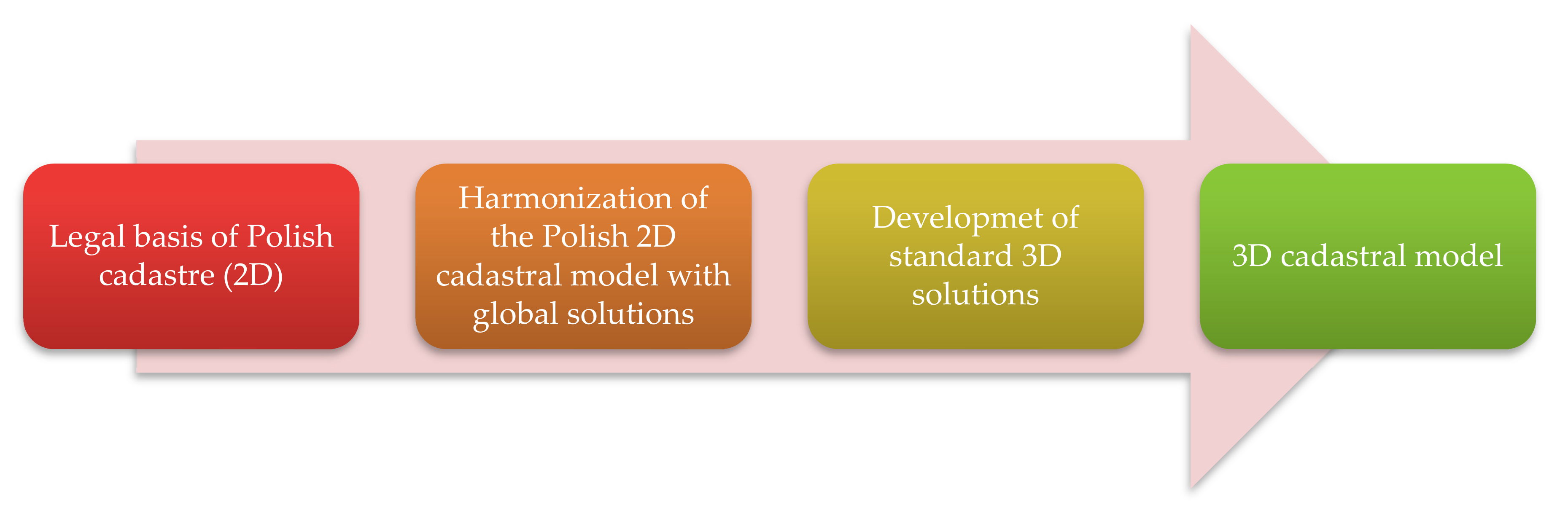
2. Methodology and Materials
3. The Cadastre and Its Development in Poland
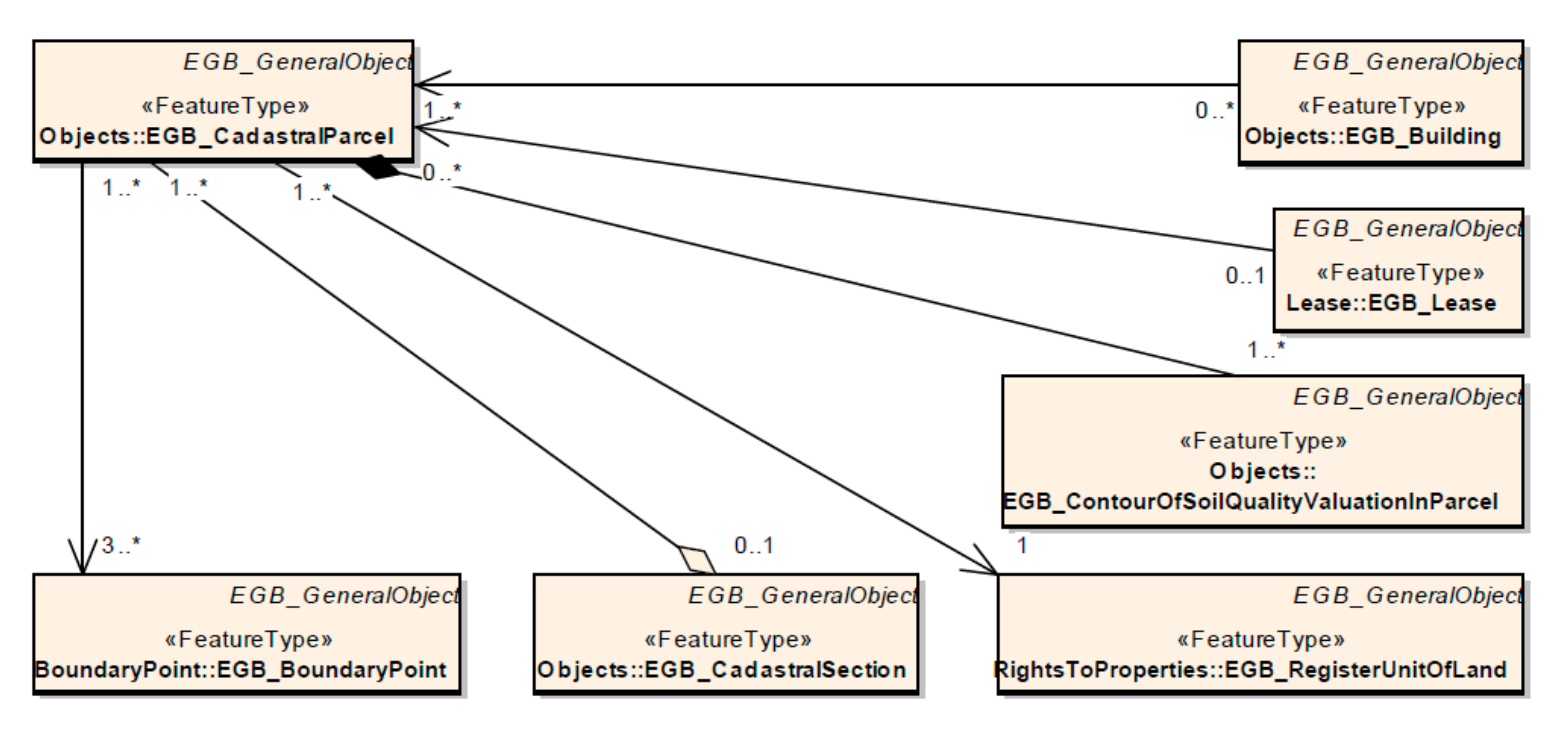
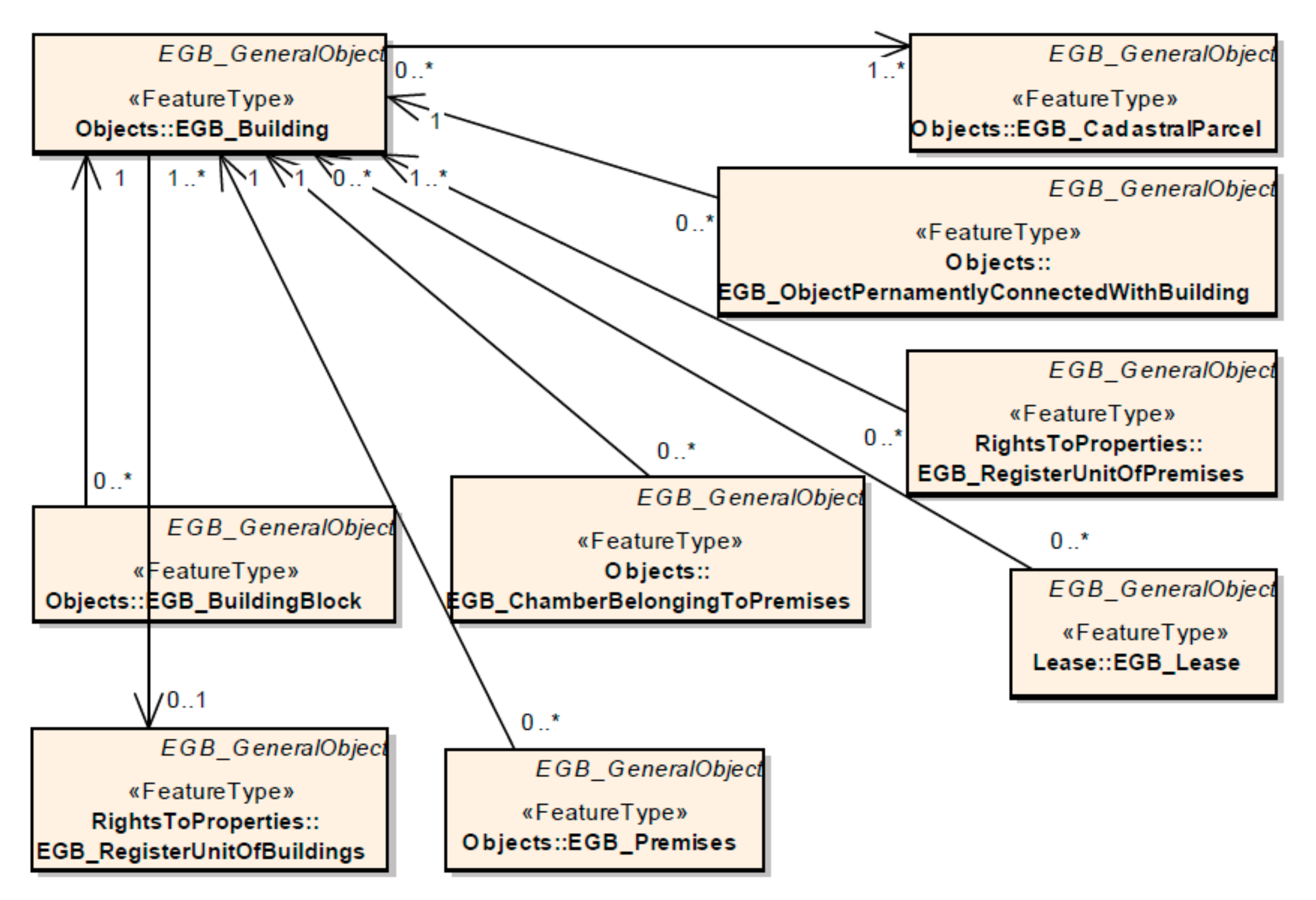
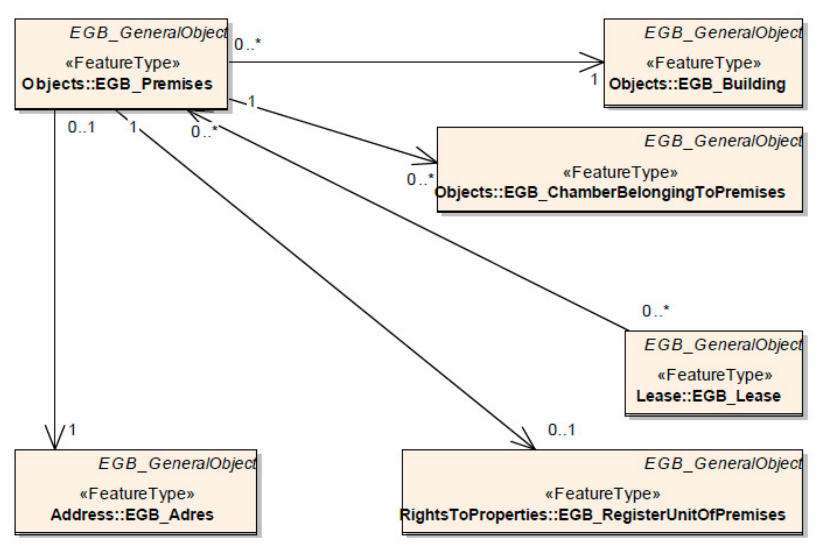
4. Creating a 3D Cadastral Model for Poland
5. Results
6. Discussion and Conclusions
Author Contributions
Funding
Acknowledgments
Conflicts of Interest
References
- FIG Joint Commission 3 and 7 Working Group on 3D Cadastres. International Workshop on “3D Cadastres”. 28–30 November 2001. Available online: www.gdmc.nl/3DCadastres/workshop2001/ (accessed on 18 September 2020).
- Oosterom, P.; Stoter, J.; Ploeger, H.; Thompson, R.; Karki, S. World-wide inventory of the status of 3D Cadastres in 2010 and expectations for 2014. In Proceedings of the FIG Working Week, Bridging the Gap between Cultures, Marrakech, Morocco, 18–22 May 2011. [Google Scholar]
- Oosterom, P.; Stoter, J.; Ploeger, H.; Lemmen, C.; Thompson, R.; Karki, S. Initial Analysis of the Second FIG 3D Cadastres Questionnaire: Status in 2014 and Expectations for 2018. In Proceedings of the 4th International Workshop on 3D Cadastres, Dubai, UAE, 9–11 November 2014. [Google Scholar]
- Oosterom, P.; Shnaidman, A.; Rahman, A.A.; Karki, S.; Lemmen, C.; Ploeger, H. Analysis of the Third FIG 3D Cadastres Questionnaire: Status in 2018 and Expectations for 2022. In Proceedings of the FIG Working Week 2019, Geospatial Information for a Smarter Life and Environmental Resilience, Hanoi, Vietnam, 22–26 April 2019. [Google Scholar]
- FIG Joint Commission 3 and 7 Working Group on 3D Cadastres. Literature. Available online: http://www.gdmc.nl/3DCadastres/literature/ (accessed on 18 September 2020).
- ISO. Geographic Information–Land Administration Domain Model (LADM); International Organization for Standardization: Geneva, Switzerland, 2012; ISO 19152:2012. [Google Scholar]
- Gilbert, T.; Rönsdorf, C.; Plume, J.; Simmons, S.; Nisbet, N.; Gruler, H.-C.; Kolbe, T.H.; Berlo, L.; Mercer, A. Built Environment Data Standards and Their Integration: An Analysis of IFC, CityGML and LandInfra. Version 1.0, 2 March 2020, OGC Document 19-091r1, bSI TR1012. Available online: https://portal.ogc.org/files/?artifact_id=92634 (accessed on 4 November 2020).
- Kumar, K.; Labetski, A.; Ohori, K.; Ledoux, H.; Stoter, J. The LandInfra standard and its role in solving the BIM-GIS quagmire. Open Geospat. Data Softw. Stand. 2019, 4, 1–16. [Google Scholar] [CrossRef]
- Oosterom, P.; Bennet, R.; Koeva, M.; Lemmen, C. 3D Land Administration for 3D Land Uses. Land Use Policy 2020, 98, 104665. [Google Scholar] [CrossRef]
- Kalioganni, E.; Oosterom, P.; Dimopoulou, E.; Lemmen, C. 3D Land Administration: A Review and a Future Vision in the Context of the Spatial Development Lifecycle. ISPRS Int. J. Geo-Inf. 2020, 9, 107. [Google Scholar] [CrossRef]
- Griffith-Charles, C.; Sutherland, M. 3D cadastres for densely occupied informal situations: Necessity and possibility. Land Use Policy 2020, 98, 104372. [Google Scholar] [CrossRef]
- Gkeli, M.; Potsiou, C.; Ioannidis, C. A technical solution for 3D crowdsourced cadastral surveys. Land Use Policy 2020, 98, 104419. [Google Scholar] [CrossRef]
- Kalioganni, E.; Dimopoulou, E.; Thompson, R.J.; Ying, S.; Lemmen, C.; Oosterom, P. Development of 3D spatial profiles to support the full lifecycle of 3D objects. Land Use Policy 2020, 98, 104177. [Google Scholar] [CrossRef]
- Kara, A.; Oosterom, P.; Çağdaş, V.; Işıkdağ, Ü.; Lemmen, C. 3 Dimensional data research for property valuation in the context of the LADM Valuation Information Model. Land Use Policy 2020, 98, 104179. [Google Scholar] [CrossRef]
- Cemellini, B.; Thompson, R.; Oosterom, P.; Vries, M. Design, development and usability testing of an LADM compliant 3D Cadastral prototype system. Land Use Policy 2020, 98, 104418. [Google Scholar] [CrossRef]
- Indrajit, A.; Loenen, B.; Ploeger, H.; Oosterom, P. Developing a spatial planning information package in ISO 19152 land administration domain model. Land Use Policy 2020, 98, 104411. [Google Scholar] [CrossRef]
- Alattas, A.; Oosterom, P.; Zlatanova, S.; Hoeneveld, D.; Verbree, E. LADM-IndoorGML for exploring user movements in evacuation exercise. Land Use Policy 2020, 98, 104219. [Google Scholar] [CrossRef]
- Tekavec, J.; Lisec, A. Cadastral data as a source for 3D indoor modelling. Land Use Policy 2020, 98, 104322. [Google Scholar] [CrossRef]
- Tekavec, J.; Lisec, A.; Rodrigues, E. Simulating Large-Scale 3D Cadastral Dataset Using Procedural Modelling. ISPRS Int. J. Geo-Inf. 2020, 9, 598. [Google Scholar] [CrossRef]
- Ghawana, T.; Sargent, J.; Bennett, R.M.; Zevenbergen, P. 3D Cadastres in India: Examining the status and potential for land administration and management in Delhi. Land Use Policy 2020, 98, 104389. [Google Scholar] [CrossRef]
- Kitsakis, D.; Dimopoulou, E. Assessing the environmental impact of 3D public law restrictions. Land Use Policy 2020, 98, 104151. [Google Scholar] [CrossRef]
- Vučić, N.; Mađer, M.; Vranić, S.; Roić, M. Initial 3D cadastre registration by cadastral resurvey in the Republic of Croatia. Land Use Policy 2020, 98, 104335. [Google Scholar] [CrossRef]
- Larsson, K.; Paasch, J.M.; Paulsson, J. Representation of 3D cadastral boundaries – From analogue to digital. Land Use Policy 2020, 98, 104178. [Google Scholar] [CrossRef]
- Döner, F.; Sirin, S. 3D Digital Representation of Cadastral Data in Turkey—Apartments Case. Land 2020, 9, 179. [Google Scholar] [CrossRef]
- Velastegui-Cáceres, J.; Rodríguez-Espinosa, V.M.; Padilla-Almeida, O. Urban Cadastral Situation in Ecuador: Analysis to Determine the Degree of Proximity of the Cadastral Systems to the 3D Cadastral Model. Land 2020, 9, 357. [Google Scholar] [CrossRef]
- Oldfield, J.; Oosterom, P.; Quak, W.; der Veen, J.; Beetz, J. Can Data from BIMs be Used as Input for a 3D Cadastre? In Proceedings of the 5th International FIG 3D Cadastre Workshop, Athens, Greece, 18–20 October 2016; pp. 199–214. Available online: https://www.fig.net/resources/proceedings/2016/2016_3dcadastre/3Dcad_2016_21.pdf.pdf (accessed on 3 November 2020).
- Oldfield, J.; Oosterom, P.; Beetz, J.; Krijnen, T.F. Working with Open BIM Standards to Source Legal Spaces for a 3D Cadastre. ISPRS Int. J. Geo-Inf. 2017, 6, 351. [Google Scholar] [CrossRef]
- Sun, J.; Mi, S.; Olsson, P.; Paulsson, J.; Harrie, L. Utilizing BIM and GIS for Representation and Visualization of 3D Cadastre. ISPRS Int. J. Geo-Inf. 2019, 8, 503. [Google Scholar] [CrossRef]
- Sladić, D.; Radulović, A.; Govedarica, M. Development of process model for Serbian cadastre. Land Use Policy 2020, 98, 104273. [Google Scholar] [CrossRef]
- Asghari, A.; Kalantari, M.; Rajabifard, A. A structured framework for 3D cadastral data validation − a case study for Victoria, Australia. Land Use Policy 2020, 98, 104359. [Google Scholar] [CrossRef]
- Alberdi, R.; Erba, D.A. Modeling Legal Land Object for waterbodies in the context of 4D cadastre. Land Use Policy 2020, 98, 104417. [Google Scholar] [CrossRef]
- Sejm of the Republic of Poland. Act of 17 May 1989—Law on Geodesy and Cartography (Journal of Laws No. 30, Item 163, as Amended). Available online: http://isap.sejm.gov.pl/isap.nsf/download.xsp/WDU19890300163/U/D19890163Lj.pdf (accessed on 21 September 2020).
- Sejm of the Republic of Poland. Regulation of Ministry of Administration and Digitization from 29th of March 2001 Concerning the Land and Building Cadastre—Consolidated Text (Journal of Laws from 2016, Item 1034). Available online: http://isap.sejm.gov.pl/isap.nsf/download.xsp/WDU20160001034/O/D20161034.pdf (accessed on 21 September 2020).
- Przewięźlikowska, A. Legal aspects of synchronising data on real property location in polish cadastre and land and mortgage register. Land Use Policy 2020, 95, 104606. [Google Scholar] [CrossRef]
- Sejm of the Republic of Poland. Act of 6 July 1982—Land Register and Mortgage (Journal of Laws No. 19, Item 147, as Amended). Available online: http://isap.sejm.gov.pl/isap.nsf/download.xsp/WDU20180001916/U/D20181916Lj.pdf (accessed on 21 September 2020).
- Dawidowicz, A.; Klimach, A.; Źróbek, R. Dynamics of Legal Changes in Polish Cadastre. In Dynamics in GIscience; Lecture Notes in Geoinformation and Cartography; Ivan, I., Horák, J., Inspektor, T., Eds.; Springer: Cham, Switzerland, 2018. [Google Scholar] [CrossRef]
- Maślanka, J. Entering Parcel Boundaries into the Polish Register of Land and Buildings—An Analysis of the Current State and Proposed Changes. Geomat. Environ. Eng. 2020, 14, 63–87. [Google Scholar] [CrossRef]
- Directive 2007/2/EC of The European Parliament and of the Council of 14 March 2007 Establishing an Infrastructure for Spatial Information in the European Community (INSPIRE). Available online: http://eur-lex.europa.eu/legal-content/EN/TXT/?uri=CELEX:32007L0002 (accessed on 21 September 2020).
- Sejm of the Republic of Poland. Act of 4 March 2010 on Spatial Information Infrastructure (Journal of Laws from 2010, No. 76, Item 489, as Ameded). Available online: http://isap.sejm.gov.pl/isap.nsf/download.xsp/WDU20100760489/U/D20100489Lj.pdf (accessed on 21 September 2020).
- Sejm of the Republic of Poland. Regulation of Ministry of Administration and Digitization from 29th of November 2013 Changing the Regulation on Land and Building Cadastre (Journal of Laws from 2013, Item 1551). Available online: http://isap.sejm.gov.pl/isap.nsf/download.xsp/WDU20130001551/O/D20131551.pdf (accessed on 21 September 2020).
- Bydłosz, J. The application of the Land Administration Domain Model in building a country profile for the Polish cadastre. Land Use Policy 2015, 49, 598–605. [Google Scholar] [CrossRef]
- Puniach, E.; Bieda, A.; Ćwiąkała, P.; Kwartnik-Pruc, A.; Parzych, P. Use of unmanned aerial vehicles (UAVs) for updating farmland cadastral data in areas subject to landslides. ISPRS Int. J. Geo-Inf. 2018, 7, 331. [Google Scholar] [CrossRef]
- Questionnaire 3D-Cadastres: Status November 2010 Poland. Available online: www.gdmc.nl/3DCadastres/participants/3D_Cadastres_Poland.pdf (accessed on 21 September 2020).
- Questionnaire 3D-Cadastres: Status September 2014 Poland. Available online: http://www.gdmc.nl/3DCadastres/participants/3D_Cadastres_Poland2014.pdf (accessed on 21 September 2020).
- 3rd Questionnaire 3D-Cadastres: Status December 2018 Poland. Available online: http://www.gdmc.nl/3DCadastres/participants/3D_Cadastres_Poland2018.pdf (accessed on 21 September 2020).
- Siejka, M.; Ślusarski, M.; Zygmunt, M. 3D + time Cadastre, possibility of implementation in Poland. Surv. Rev. 2014, 46, 79–89. [Google Scholar] [CrossRef]
- Karabin, M. A Concept of a Model Approach to the 3D Cadastre in Poland: Technical and Legal Aspects. In Proceedings of the 4th International Workshop on 3D Cadastres, Dubai, UAE, 9–11 November 2014. [Google Scholar]
- Góźdź, K.; Pachelski, W.; Oosterom, P.; Coors, V. The Possibilities of Using CityGML for 3D Representation of Buildings in the Cadastre. In Proceedings of the 4th International Workshop on 3D Cadastres, Dubai, UAE, 9–11 November 2014. [Google Scholar]
- Bydłosz, J. Modelowanie informacji katastralnej (Modelling of cadastral information). In Modelowanie Informacji Geograficznej Dla Potrzeb Budowy Infrastruktury Informacji Przestrzennej; Bielecka, E., Pachelski, W., Eds.; Wojskowa Akademia Techniczna: Warszawa, Poland, 2014; pp. 19–35. [Google Scholar]
- Bydłosz, J. Developing the Polish Cadastral Model Towards 3D Cadastre. In Proceedings of the 5th International FIG 3D Cadastre Workshop, Athens, Greece, 18–20 October 2016; pp. 505–518. Available online: Fig.net/resources/proceedings/2016/2016_3dcadastre/3Dcad_2016_38.pdf.pdf (accessed on 25 September 2020).
- Bydłosz, J.; Bieda, A.; Parzych, P. The Implementation of Spatial Planning Objects in a 3D Cadastral Model. ISPRS Int. J. Geo-Inf. 2018, 7, 153. [Google Scholar] [CrossRef]
- Karabin, M.; Kitsakis, D.; Koeva, M.; Navratil, G.; Paasch, J.; Paulsson, J.; Vučić, N.; Janečka, K.; Lisec, A. Layer Approach to Ownership in 3D Cadastre—A Subway Case. In Proceedings of the 6th International Workshop on 3D Cadastres, Delft, The Netherlands, 2–4 October 2018; pp. 111–136. [Google Scholar]
- Karabin, M. Rules concerned Registration of the Spatial Objects in Poland in the Context of 3D Cadastre’s Requirements. In Proceedings of the 2nd International Workshop on 3D Cadastres, Delft, the Netherlands, 16–18 November 2011; pp. 433–452. [Google Scholar]
- Karabin, M.; Bakuła, K.; Fijałkowska, A.; Karabin-Zych, M. Feasibility study of 3D cadastre implementation using various data sources—The case of Warsaw Subway. Geod. Vestn. 2018, 3, 445–457. [Google Scholar] [CrossRef]
- Bydłosz, J. The cadastre in Poland—The Current Status and Possibilities of Transformation into 3D One. In Proceedings of the FIG Working Week 2012: Knowing to Manage the Territory, Protect the Environment, Evaluate the Cultural Heritage, Rome, Italy, 6–10 May 2012; pp. 1–9. Available online: http://www.gdmc.nl/3dcadastres/literature/3Dcad_2012_11.pdf (accessed on 21 September 2020).
- Bieda, A.; Bydłosz, J.; Warchoł, A.; Balawejder, M. Historical Underground Structures as 3D Cadastral Objects. Remote Sens. 2020, 12, 1547. [Google Scholar] [CrossRef]
- Head Office of Geodesy and Cartography. Regulation of Ministry of Administration and Digitization from 29th of November 2013 (with Later Changes)—Application Schemas. Available online: http://www.gugik.gov.pl/bip/prawo/schematy-aplikacyjne/rozporzadzenie-ministra-administracji-i-cyfryzacji-z-dnia-6-listopada-2015-r.-zmieniajace-rozporzadzenie-w-sprawie-ewidencji-gruntow-i-budynkow (accessed on 22 September 2020).
- Bydłosz, J. Przyszłe obiekty katastru 3D w Polsce—Future objects of 3D cadastre in Poland. Acta Sci. Pol. Adm. Locorum 2017, 16, 231–237. [Google Scholar]
- Regulation of the Council of Ministers of 30 December 1999 on the Polish Classification of Construction Objects (PCCO). Journal of Laws from 1999, No. 112, Item 1316. Available online: http://isap.sejm.gov.pl/isap.nsf/DocDetails.xsp?id=WDU19991121316 (accessed on 21 September 2020).
- Sejm of the Republic of Poland. Act of 24 June 1994 on the Ownership of Premises—Consolidated Text. Journal of Laws from 2020, Item 532. Available online: https://isap.sejm.gov.pl/isap.nsf/download.xsp/WDU20200000532/U/D20200532Lj.pdf (accessed on 22 September 2020).
- Dawidowicz, A.; Zysk, E.; Źróbek, R. A Methodological Evaluation of the Polish Land Administration System Using the Fit for Purpose Approach. Geomat. Environ. Eng. 2020, 14, 31–47. [Google Scholar] [CrossRef]
- Kwiecień, J.; Krajewska, M.; Szopińska, K. Design and Implementation of a Spatial Database for the Analysis of Residential Estate Market. In Proceedings of the Geographic Information Systems Conference and Exhibition “GIS Odyssey 2018”—Conference Proceedings, Perugia, Italy, 10–14 September 2018; pp. 328–333. [Google Scholar]
- Geoportal 3D. Available online: https://mapy.geoportal.gov.pl/imap/Imgp_2.html?gpmap=imap3d (accessed on 25 September 2020).


| No. | Proposed Class Name in Polish Cadastral Model (In Polish) | Proposed Class Name in Polish Cadastral Model (In English) | Corresponding LADM Class |
|---|---|---|---|
| 1 | EGB_DzialkaKatastralna3D | EGB_CadastralParcel3D | LA_SpatialUnit |
| 2 | EGB_PrzestrzenPrawna-Budynku3D | EGB_BuildingLegalSpace3D | LA_LegalSpaceBuilding-Unit |
| 3 | EGB_BlokBudynku-Naziemny3D | EGB_BuildingBlock-Aboveground3D | LA_LegalSpaceBuilding-Unit |
| 4 | EGB_ BlokBudynku-Podziemny3D | EGB_BuildingBlock-Underground3D | LA_LegalSpaceBuilding-Unit |
| 5 | EGB_WspolnaCzesc-Budynku3D | EGB_BuildingCommonPart3D | LA_LegalSpaceBuilding- Unit |
| 6 | EGB_CzescBudynkuZ-NiewydzielonymiLokalami3D | EGB_BuildingPartOfNon-ExtractedPremises3D | LA_LegalSpaceBuilding-Unit |
| 7 | EGB_Lokal3D | EGB_Premises3D | LA_LegalSpaceBuilding-Unit |
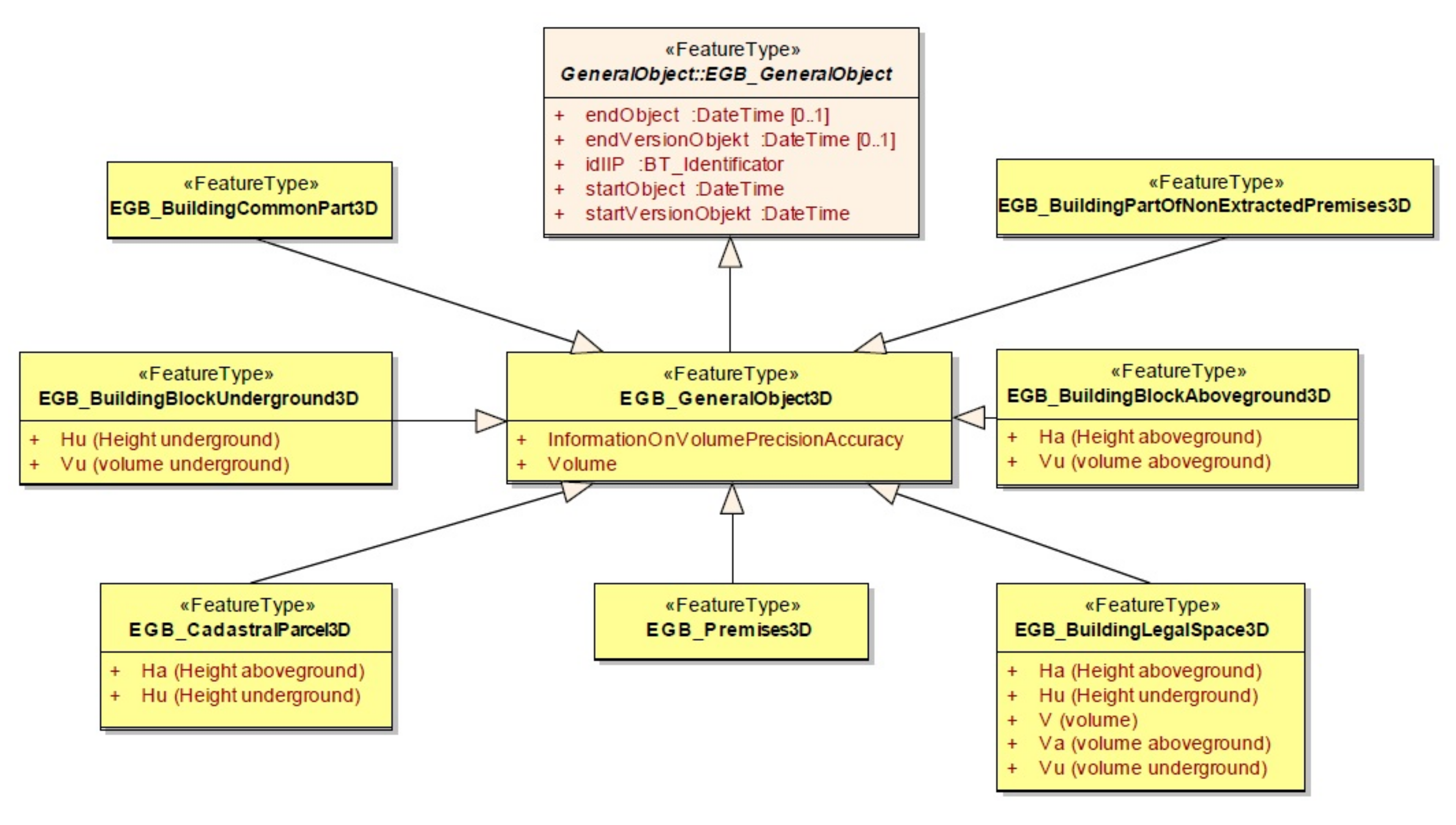
| 8 | EGB_ObiektOgolny3D | EGB_GeneralObject3D | VersionedObject |
| No. | Diagram Name in the Polish Cadastral Model (In Polish) | Diagram Name in the Polish Cadastral Model (In English) |
|---|---|---|
| 1 | OgolnyObiekt | GeneralObject |
| 2 | Dziedziczenie | Inheritance |
| 3 | JednEwidObreb | CadastComplexCadastSection |
| 4 | DzialkaKlasouzytek | ParcelContourOfSoilQualityValuationInParcel |
| 5 | BudynekLokal | BuildingPremises |
| 6 | DanePrzedmiotoweSlowniki | ObjectDataGlossaries |
| 7 | PodmiotEwidencyjny | Party |
| 8 | PodmiotEwidencyjnySlowniki | PartiesGlossaries |
| 9 | JednostkiRejestrowe | RegisterUnits |
| 10 | Udzialy | Shares |
| 11 | GrupowanieJRPodmiotow | RegisterUnitsPartiesGrouping |
| 12 | PrawaDoNieruchomosciSlowniki | RightsToPropertiesGlossaries |
| 13 | Adres | Address |
| 14 | PunktGraniczny | BoundaryPoint |
| 16 | Dzierzawa | Lease |
| 16 | PodstawaPrawna | LegalBasis |
| 17 | Dzialka3Dbudynek3D | Parcel3Dbuilding3D |
| 18 | Lokal3D | Premises3D |
| 19 | ObiektOgolny3D | GeneralObject3D |
Publisher’s Note: MDPI stays neutral with regard to jurisdictional claims in published maps and institutional affiliations. |
© 2020 by the authors. Licensee MDPI, Basel, Switzerland. This article is an open access article distributed under the terms and conditions of the Creative Commons Attribution (CC BY) license (http://creativecommons.org/licenses/by/4.0/).
Share and Cite
Bydłosz, J.; Bieda, A. Developing a UML Model for the 3D Cadastre in Poland. Land 2020, 9, 466. https://doi.org/10.3390/land9110466
Bydłosz J, Bieda A. Developing a UML Model for the 3D Cadastre in Poland. Land. 2020; 9(11):466. https://doi.org/10.3390/land9110466
Chicago/Turabian StyleBydłosz, Jarosław, and Agnieszka Bieda. 2020. "Developing a UML Model for the 3D Cadastre in Poland" Land 9, no. 11: 466. https://doi.org/10.3390/land9110466
APA StyleBydłosz, J., & Bieda, A. (2020). Developing a UML Model for the 3D Cadastre in Poland. Land, 9(11), 466. https://doi.org/10.3390/land9110466