The Textuality of the Modernist Rural Landscape: Belgrade Agricultural Combine (PKB) as a Driver of the Urban Development of Third Belgrade


Abstract
:
1. Introduction
1.1. Modernist Rural Landscape
1.2. Objectives and Paper Outline
- What are the impacts of socialist agrarian policy on the use of land in the wider metropolitan area of Belgrade?
- What is the impact of the agricultural combine as a spatial, social, economic, environmental and political entity on the urban development process?
- What is the relationship between the ideology of the socialist self-management society and spatial planning in the context of the Belgrade Agricultural Combine (PKB)?
- How is the production of modernist rural landscapes manifested at different spatial levels?
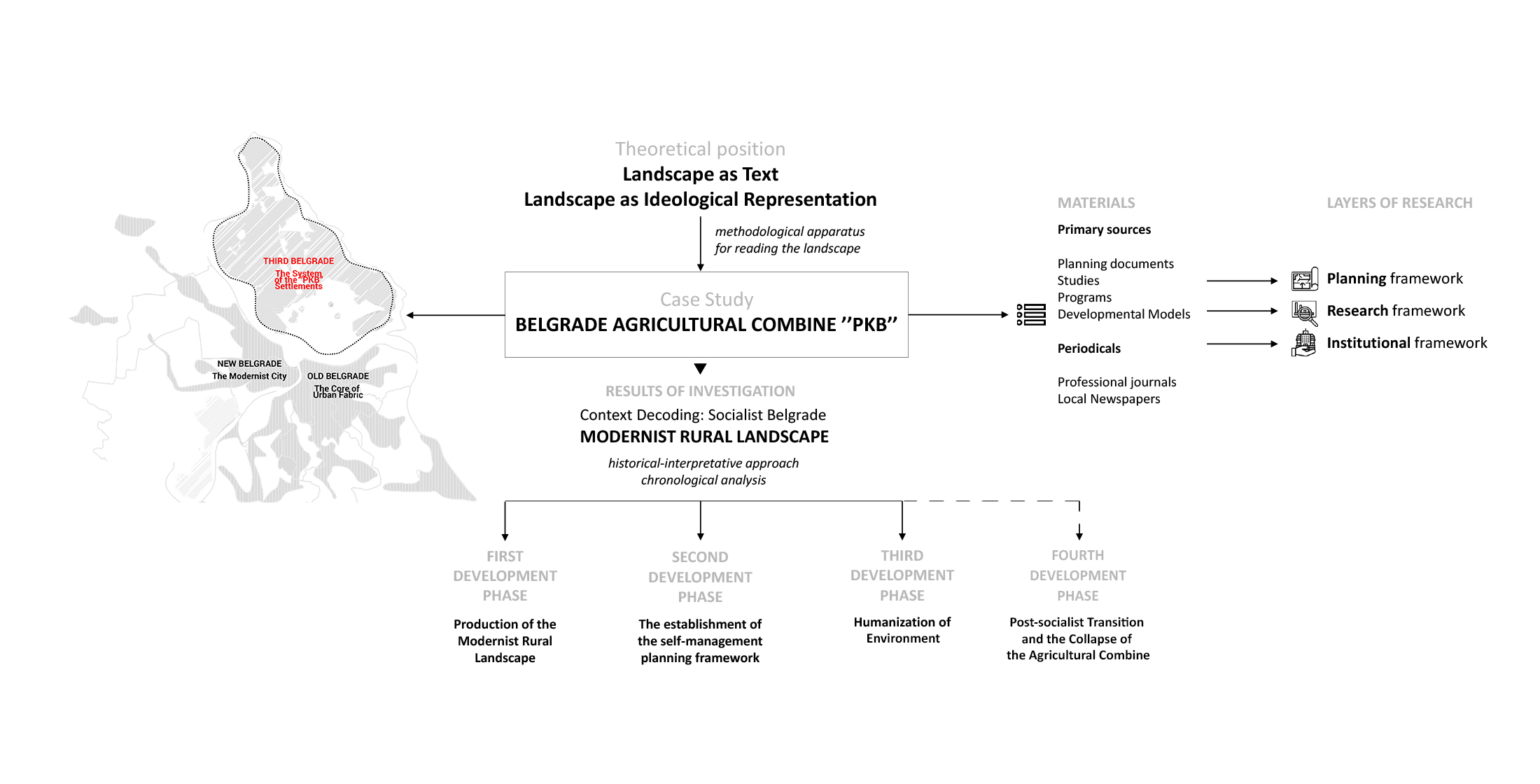
2. Materials and Methods
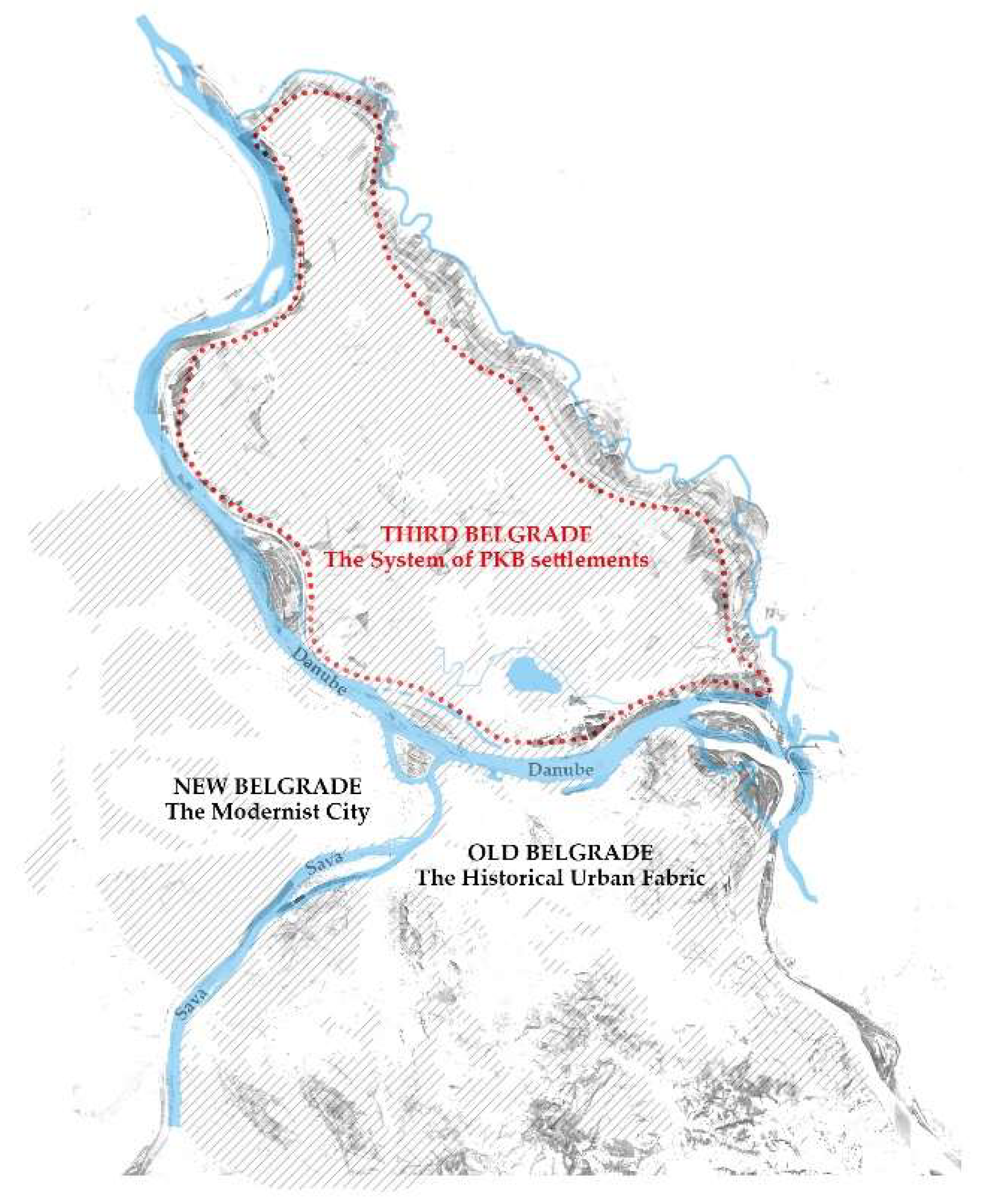
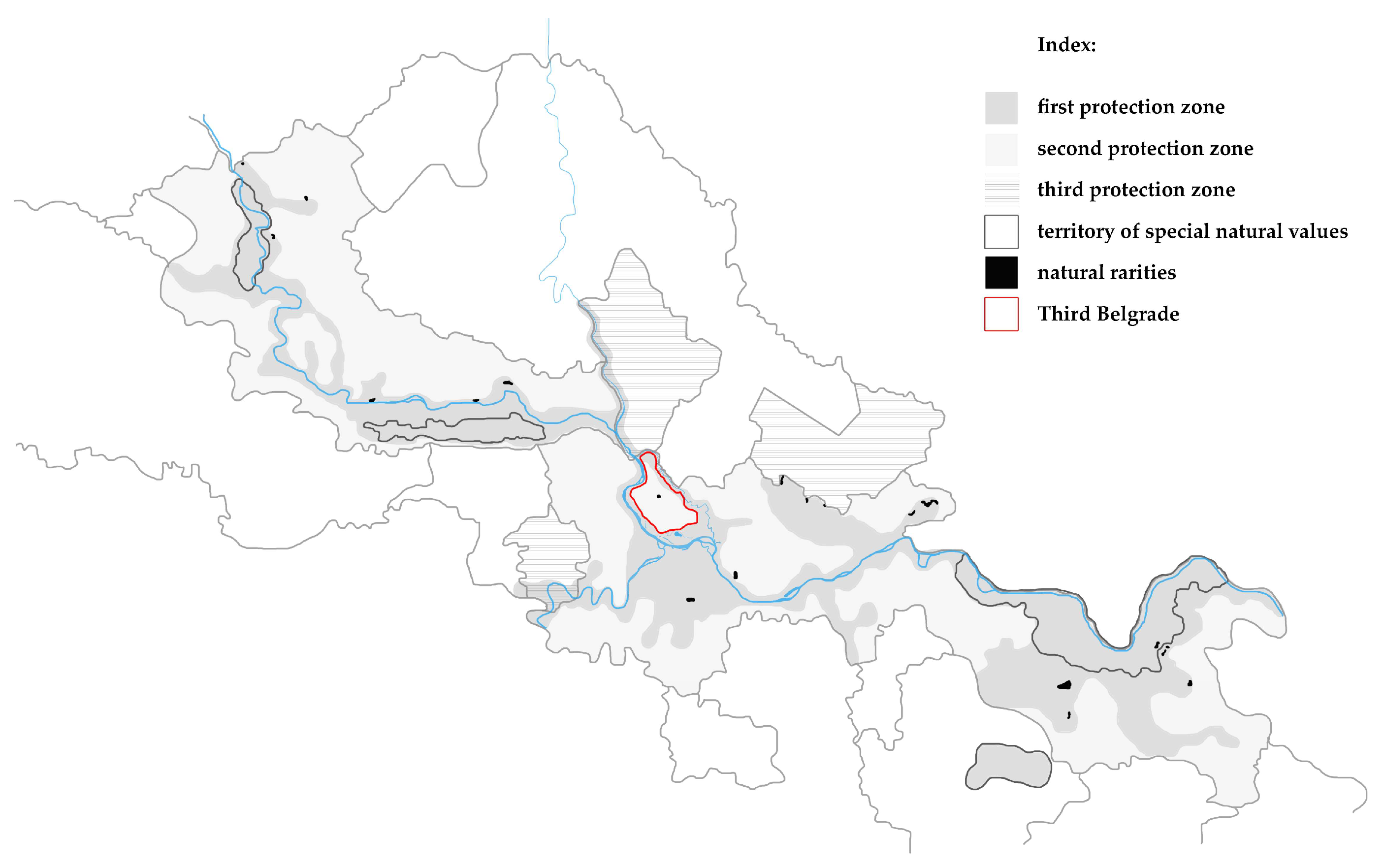
2.1. Study Case Area
2.2. Data and Methodology
- Data Collection—collection of relevant data based on primary sources related to the urban planning and development of the territory of Third Belgrade. The primary sources include available historical and archival material, as well as plans and strategies that have been verified and publicly available by relevant institutions;
- Data Systematization and Clustering—chronological systematization of collected data in accordance with the type of source and their classification into clusters of sources: plan, study, program, policy, institution establishment;
- Content analysis for each cluster of sources—recognition of key intentions for the planning and development of Third Belgrade, identification of planning concepts;
- Periodization of urban development—identification of the developmental periods of Third Belgrade in accordance with the planning framework, institutional and policy framework, and conceptual framework;
- Mapping urban development—establishing a connection between the planned and the realized, monitoring morphogenesis;
3. Findings and Discussion
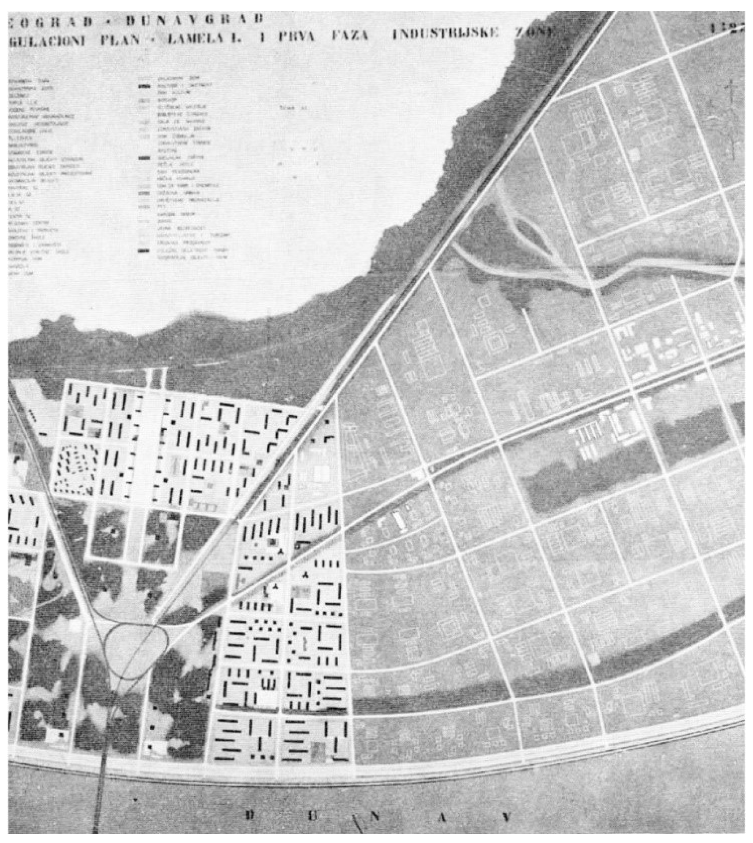
3.1. First Phase: Production of the Modernist Rural Landscape
3.2. Second Phase: Establishment of the Self-Management Planning Framework
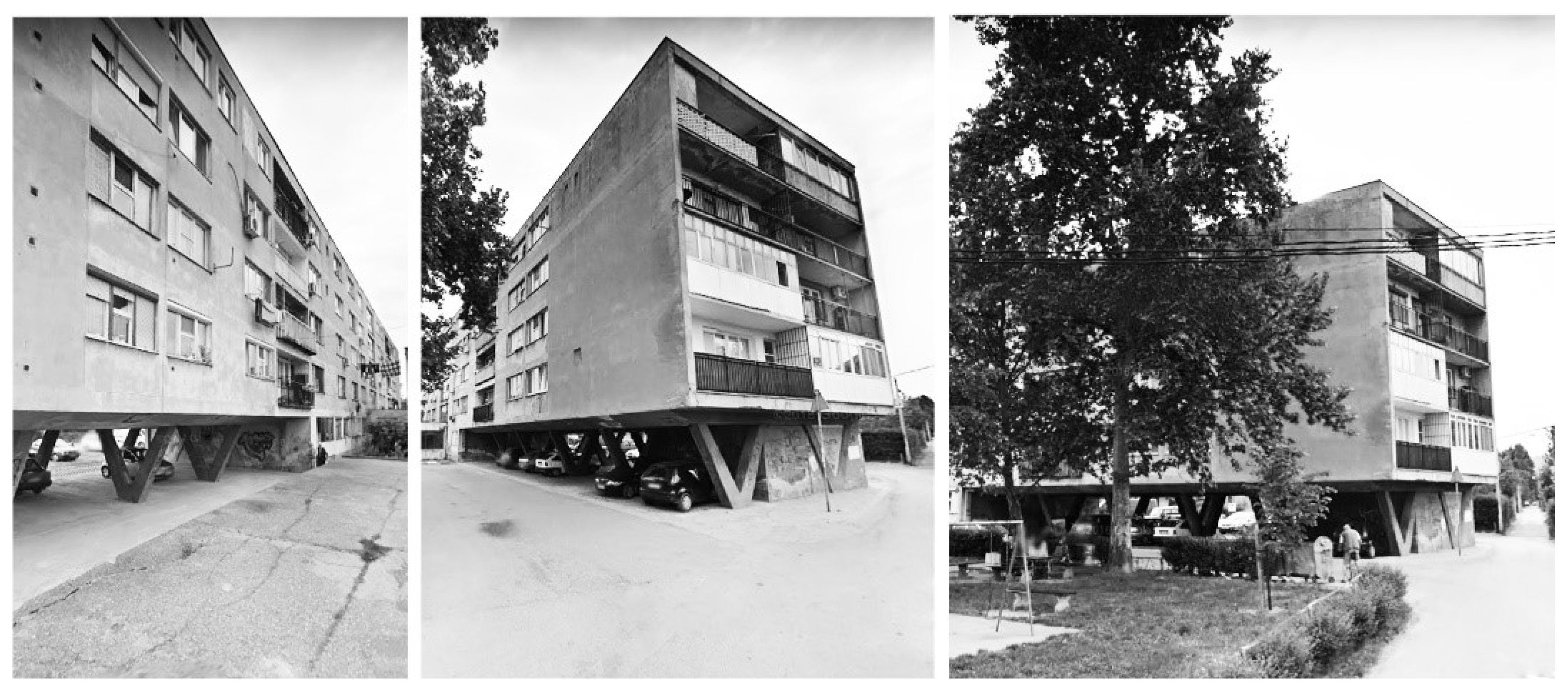
3.3. Third Phase: Humanization of Environment
3.4. Fourth Phase: Post-Socialist Transition and the Collapse of the Agricultural Combine
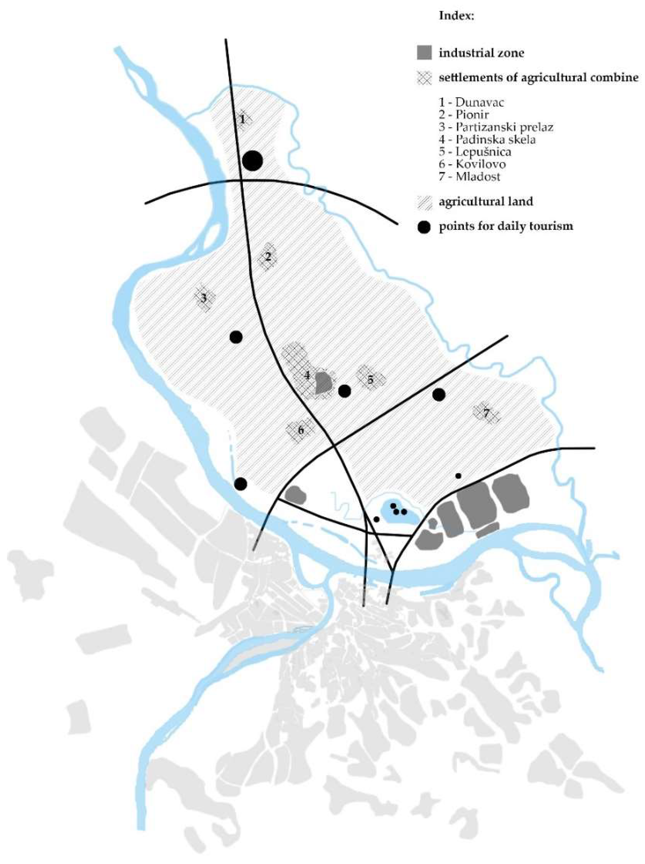
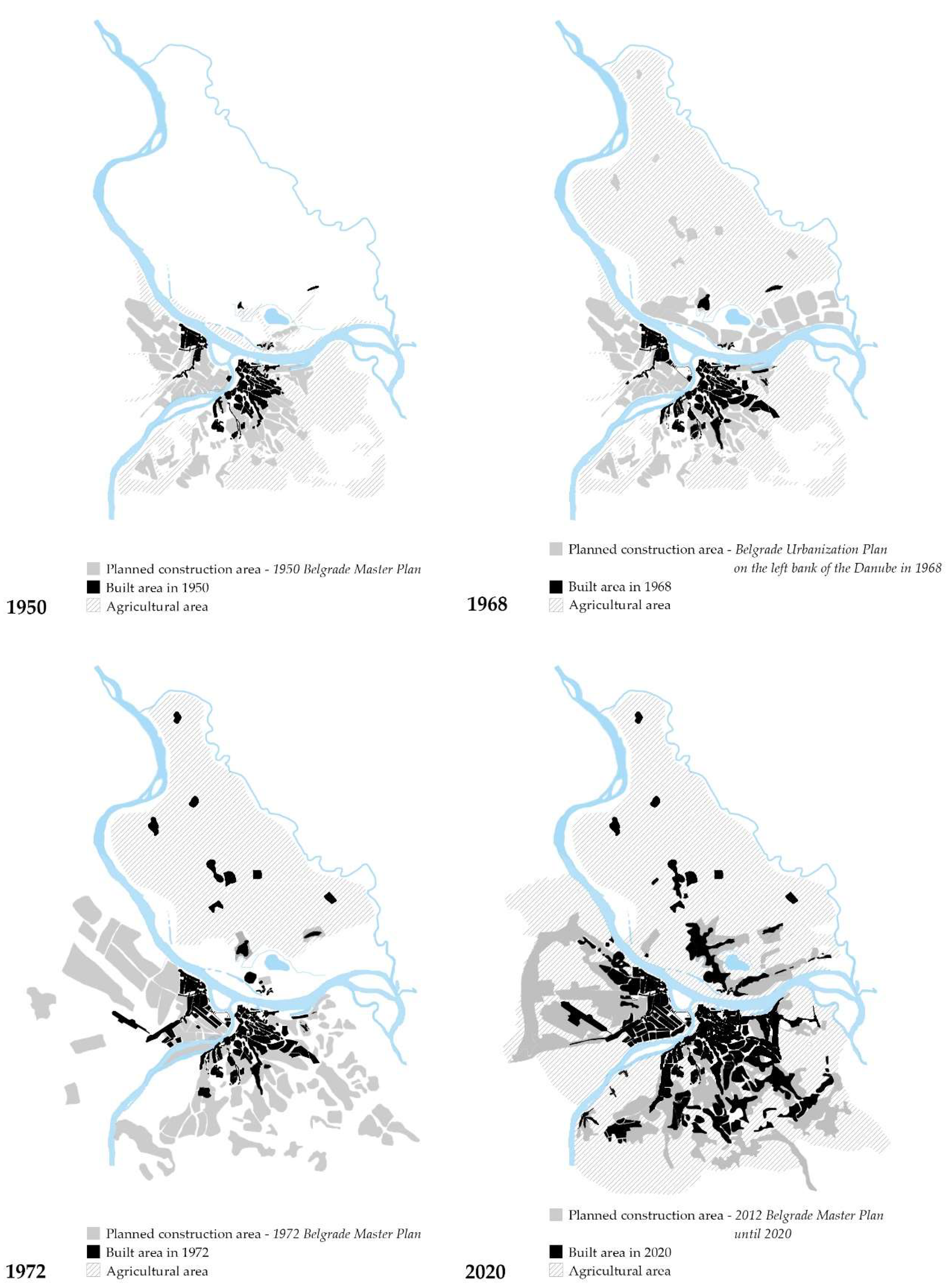
3.5. Synthesis: Mapping Landscape Transformation of PKB
4. Conclusions
- What are the impacts of socialist agrarian policy on the use of land in the wider metropolitan area of Belgrade?
- What is the impact of the agricultural combine as a spatial, social, economic, environmental and political entity on the urban development process?
- What is the relationship between the ideology of socialist self-governing society and spatial planning in the context of the Belgrade Agricultural Combine (PKB)?
- How is the production of the modernist rural landscape manifested at different spatial levels?
Author Contributions
Funding
Conflicts of Interest
References
- Hoskins, W.G. Making of the English Landscape; Penguin: London, UK, 1954. [Google Scholar]
- Wylie, J. Landscape; Routledge: London, UK, 2007. [Google Scholar]
- Widgren, M. Can Landscapes be Read? In European Rural Landscapes: Persistence and Change in a Globalising Environment; Palang, H., Sooväli, H., Antrop, M., Setten, G., Eds.; Springer: Dordrecht, The Netherlands, 2004; pp. 455–465. [Google Scholar] [CrossRef]
- Macura, M. Tuge i ushiti pejzaža. Arhit. Urban. 1969, 56–57, 45. [Google Scholar]
- Toth, R.E. Theory and language in landscape analysis, planning, and evaluation. Landsc. Ecol. 1988, 1, 193–201. [Google Scholar] [CrossRef]
- Council of Europe. European Landscape Convention; European Treaty Series; Council of Europe: Strasbourg, France, 2005. [Google Scholar]
- Duncan, J.S. City as Text.: Politics of Landscape Interpretation in the Kandyan Kingdom; Cambridge University Press: Cambridge, UK, 1990. [Google Scholar]
- Daniels, S. Marxism, culture, and the duplicity of landscape. In New Models in Geography; Peet, R., Thrift, N., Eds.; Unwin-Hyman: London, UK, 1989; Volume 2, pp. 196–220. [Google Scholar]
- Cosgrove, D. Landscape: Ecology and semiosis. In Landscape Interfaces: Cultural Heritage in Changing Landscapes; Palang, H., Fry, G., Eds.; Kluwer Academic Publishers: Dordrecht, The Netherlands, 2003; pp. 15–21. [Google Scholar]
- Duncan, J.; Duncan, N. (Re)Reading the Landscape. Environ. Plan. D Soc. Space 1988, 6, 117–126. [Google Scholar] [CrossRef]
- Mitchell, W.J.T. Landscape and Power; University of Chicago Press: Chicago, IL, USA, 2002. [Google Scholar]
- Harvey, D. Consciousness and the Urban. Experience; Basil Blackwell: Oxford, UK, 1985. [Google Scholar]
- Lindholm, G. Land and Landscape; Linking Use, Experience and Property Development in Urban Areas. Land 2019, 8, 137. [Google Scholar] [CrossRef] [Green Version]
- Lawrence, G. Globalisation, agricultural production systems and rural restructuring. In Sustainability and Change in Rural Australia; Cocklin, C., Dibden, J., Eds.; New South Wales University Press: Sydney, Australia, 2005; pp. 104–120. [Google Scholar]
- Fisher, A.; Bell, S.; Capresi, V.; Maia, M.H.; Pallini, C. Introduction. SHS Web Conf. 2019, 63. [Google Scholar] [CrossRef]
- Doevendans, K.; Lörzing, H.; Schram, A. From modernist landscapes to New Nature: Planning of rural utopias in the Netherlands. Landsc. Res. 2007, 32, 333–354. [Google Scholar] [CrossRef]
- Heyde, S. The Dutch tradition of modernist landscape architecture and the legacy of Hans Warnau (1922–1995). Stud. Hist. Gard. Des. Landsc. 2018, 38, 57–72. [Google Scholar] [CrossRef]
- Marcolin, P.; Flores, J.; Matias, I. Building the Modernist rural landscape in the Salazar’s Regime: The agricultural colony of Boalhosa. SHS Web Conf. 2019, 63. [Google Scholar] [CrossRef] [Green Version]
- Mandić, S. Struktura Regiona Beograda. Beograd: Generalni Urbanistički Plan 1950; Izvršni odbor N.O. Beograda: Beograd, Serbia, 1951. [Google Scholar]
- Božović, G. Budućnost pseudourbanog predela. Arhit. Urban. 1987, 98, 4. [Google Scholar]
- Lefebvre, H. Urbana Revolucija; Nolit: Beograd, Serbia, 1974. [Google Scholar]
- Stefanović, D. Specifičnosti Procesa Urbanizacije u Jugoslaviji u Periodu od 1945. do 1961. Godine; Faculty of Economics—University of Belgrade: Beograd, Serbia, 1971. [Google Scholar]
- Papić, D. Uticaj doseljenika iz ruralnih područja na gradsku sredinu. Urban. Beogr. 1973, 20, 22–23. [Google Scholar]
- Halpern, J.M. Farming as a Way of Life: Yugoslav Peasant Attitudes. In Soviet and East European Agriculture; Karcz, J.F., Ed.; University of California Press: Berkeley, CA, USA, 1967; pp. 356–381. [Google Scholar]
- Fisher, A.; Bell, S.; Capresi, V.; Maia, M.H.; Pallini, C. Modernist Reinventions of the Rural Landscape; Routledge: London, UK, 2020. [Google Scholar]
- Bereskin, E. Modern rural landscapes in contemporary heritage imaginaries: The case of Germany’s southern Oderbruch. SHS Web Conf. 2019, 63, 11002. [Google Scholar] [CrossRef] [Green Version]
- Renes, H.; Centeri, C.; Kruse, A.; Kučera, Z. The Future of Traditional Landscapes: Discussions and Visions. Land 2019, 8, 98. [Google Scholar] [CrossRef] [Green Version]
- Duncan, J.; Ley, D. Place/Culture/Representation; Routledge: London, UK, 1993. [Google Scholar]
- Barnes, T.J.; Duncan, J.S. Writing Worlds: Discourse, Text. and Metaphor in the Representation of Landscape; Routledge: London, UK, 1992. [Google Scholar]
- Nikezić, A.; Marković, D. Place-Based Education in the Architectural Design Studio: Agrarian Landscape as a Resource for Sustainable Urban Lifestyle. Sustainability 2015, 7, 9711–9733. [Google Scholar] [CrossRef] [Green Version]
- Milovanović, A. Treći Beograd: Pregled razvoja urbanističke misli i delovanja u periodu od 1921. godine do danas. Arhit. Urban. 2018, 16–25. [Google Scholar] [CrossRef]
- Pazúr, R.; Lieskovský, J.; Bürgi, M.; Müller, D.; Lieskovský, T.; Zhang, Z.; Prischchepov, A.V. Abandonment and Recultivation of Agricultural Lands in Slovakia—Patterns and Determinants from the Past to the Future. Land 2020, 9, 316. [Google Scholar] [CrossRef]
- Estel, S.; Kuemmerle, T.; Alcántara, C.; Levers, C.; Prishchepov, A.; Hostert, P. Mapping farmland abandonment and recultivation across Europe using MODIS NDVI time series. Remote Sens. Environ. 2015, 163, 312–325. [Google Scholar] [CrossRef]
- Baumann, M.; Kuemmerle, T.; Elbakidze, M.; Ozdogan, M.; Radeloff, V.C.; Keuler, N.S.; Prishchepov, A.V.; Kruhlov, I.; Hostert, P. Patterns and drivers of post-socialist farmland abandonment in Western Ukraine. Land Use Policy 2011, 28, 552–562. [Google Scholar] [CrossRef]
- Janus, J.; Bozek, P. Land abandonment in Poland after the collapse of socialism: Over a quarter of a century of increasing tree cover on agricultural land. Ecol. Eng. 2019, 138, 106–117. [Google Scholar] [CrossRef]
- Milojević, M.P.; Maruna, M.; Djordjević, A. Transition of Collective Land in Modernistic Residential Settings in New Belgrade, Serbia. Land 2019, 8, 174. [Google Scholar] [CrossRef] [Green Version]
- Djokić, V.; Ristić Trajković, J.; Krstić, V. An Environmental Critique: Impact of Socialist Ideology on the Ecological and Cultural Sensitivity of Belgrade’s Large-Scale Residential Settlements. Sustainability 2016, 8, 914. [Google Scholar] [CrossRef] [Green Version]
- Marić, I.; Niković, A.; Manić, B. Transformation of the New Belgrade urban tissue: Filling the space instead of interpolation. Spatium 2010, 22, 47–56. [Google Scholar] [CrossRef]
- Milinković, M.; Ćorović, D.; Vuksanović-Macura, Z. Historical Enquiry as a Critical Method in Urban Riverscape Revisions: The Case of Belgrade’s Confluence. Sustainability 2019, 11, 1177. [Google Scholar] [CrossRef] [Green Version]
- Miljković, D. Dosadašnji razvoj—Problemi i osnovne koncepcije budućeg razvoja Beograda. In Godišnjak Muzeja Grada Beograda; Muzej grada Beograda: Beograd, Serbia, 1964; pp. 27–72. [Google Scholar]
- Milošević, S. Agrarna Politika u Jugoslaviji (1945–1953); Faculty of Philosophy—University of Belgrade: Beograd, Serbia, 2015. [Google Scholar]
- Radenković, I.; Solar, M. From Arable Land through Socialist Industrialisation to the Dinner Table and Social Life. In We Have Built Cities for You: On the contradictions of Yugoslav socialism; Knežević, V., Miletić, M., Eds.; Center CZKD—Center for Cultural Decontamination: Belgrade, Serbia, 2018; pp. 155–169. [Google Scholar]
- Kojić, B. Poljoprivredna Arhitektura. Projektovanje Privrednih i Industrijskih Zgrada, 3rd ed.; Narodna Knjiga: Beograd, Serbia, 1957. [Google Scholar]
- Stojanović, B. Beograd na levoj obali Dunava. In Godišnjak Muzeja Grada Beograda; Muzej grada Beograda: Beograd, Serbia, 1971; pp. 333–383. [Google Scholar]
- Zeitoun, J. Predeo. Arhit. Urban. 1969, 56–57, 27. [Google Scholar]
- Macura, M. Međuzavisnosti reintegracije arhitektonskog prostora i samoupravnog socijalističkog razvoja. Arhit. Urban. 1978, 80–81, 49. [Google Scholar]
- Pavlovic, A. Standard nije samo krov nad glavom—Iz izlaganja Aleksandra Pavlovića, zamenika generalnog direktora Kombinata, na godišnjoj skupštini Sindikata. In Poljoindustrija—List Radnog Kolektiva Poljoprivrednog Kombinata Beograd; PK Beograd: Beograd, Serbia, 1969; p. 4. [Google Scholar]
- Djurovic, D. Sociološki pristup planiranju budućeg razvoja Beograda. Urban. Beogr. 1969, 4, 19. [Google Scholar]
- Delcourt, H.R.; Delcourt, P.A. Quaternary landscape ecology: Relevant scales in space and time. Landsc. Ecol. 1988, 2, 23–44. [Google Scholar] [CrossRef]
- Anonim. Čovek u gigantu. In Poljoindustrija—List Radnog Kolektiva Poljoprivrednog Kombinata Beograd; PK Beograd: Beograd, Serbia, 1969; p. 11. [Google Scholar]
- Anonim. Model samoupravnog planiranja. In Poljoindustrija—List Radnog Kolektiva Poljoprivrednog Kombinata Beograd; PK Beograd: Beograd, Serbia, 1974; p. 7. [Google Scholar]
- Stojanović, B. Zaštita čovekove okoline urbanizmom. Urban. Beogr. 1975, 31, 1–7. [Google Scholar]
- Ristić-Trajković, J.; Stojiljković, D. Sustainability and Socialism: Socio-ecological ideas in urbanization of New Belgrade. Facta Univ. Ser. Archit. Civil Eng. 2016, 14, 343–353. [Google Scholar] [CrossRef]
- Stojiljković, D.; Ristić, J. Development of environmental consciousness in urbanization process of Belgrade in the second half of the XX century. In Proceedings of the III International Symposium for Students of Doctoral Studies in the Fields of Civil Engineering, Architecture and Environmental Protection, Novi Sad, Serbia, 21–23 September 2011; pp. 333–338. [Google Scholar]
- Stojanović, B. Čovek i životna sredina. Urban. Beogr. 1973, 23, 3–5. [Google Scholar]
- Popović, S. Ostvarivanje zaštite životne sredine u jugoslovenskom samoupravnom sistemu. In Zbornik Radova Pravnog Fakulteta iz Niša; Univerzitet u Nišu - Pravni fakultet, Niš: Serbia, 1979; pp. 5–47. [Google Scholar]
- Tomić, V. Humanizacija života u gradu. Urban. Beogr. 1980, 59–60, 25–27. [Google Scholar]
- Friedman, A.D. The Legal Choice in a Cultural Landscape: An Explanatory Model Created from the Maritime and Terrestrial Archaeological Record of the Roanoke River, North Carolina; PAST Foundation: Columbus, OH, USA, 2008. [Google Scholar]
- Djordjevic, A. Ekspoze. Urban. Beogr. 1972, 19, 11–19. [Google Scholar]
- Perišić, D. Tretiranje prirodne sredine u fazi generalnog urbanističkog planiranja. Urban. Beogr. 1972, 19, 63–65. [Google Scholar]
- Stojanović, B. For an analytical review of the current housing construction: Koteži (In Serbian). Urban. Beogr. 1975, 30, 61–62. [Google Scholar]
- Strugar, M. Prostorni plan Beograda na levoj obali Dunava i Generalni planovi naselja PKB-a. Urban. Beogr. 1980, 56, 59–60. [Google Scholar]
- United Nations. Report of the United Nations Conference on the Human Environment, Stockholm, 5–16 June 1972; United Nations: New York, NY, USA, 1973. [Google Scholar]
- Mendelson, A. Razmišljanja o čovekovoj okolini i stanovanju. In Godišnjak Muzeja Grada Beograda; Muzej grada Beograda: Beograd, Serbia, 1976; pp. 259–277. [Google Scholar]
- Stojanović, B. Greenery in Spatial Planning. Arhit. Urban. 1969, 56–57, 54–55. (In Serbian) [Google Scholar]
- European Commission. Pan-European Biological and Landscape Diversity Strategy, Nature and Environment. In Proceedings of the Council of Europe at the Ministerial Conference ”Environment for Europe”, Sofia, Bulgaria, 23–25 October 1995; Council of Europe Press: Strasbourg, France, 1996. [Google Scholar]
- European Commission. The EU Strategy for the Danube Region—A United Response to Common Challenges; European Union, Directorate-General for Regional Policy: Brussels, Belgium, 2011. [Google Scholar]
- Ustaoglu, E.; Collier, M.J. Farmland abandonment in Europe: An overview of drivers, consequences, and assessment of the sustainability implications. Environ. Rev. 2018, 26, 396–416. [Google Scholar] [CrossRef]
- Alix-Garcia, J.; Kuemmerle, T.; Radeloff, V.C. Prices, land tenure institutions, and geography: A matching analysis of farmland abandonment in post-socialist Eastern Europe. Land Econ. 2012, 88, 425–443. [Google Scholar] [CrossRef]
- Prishchepov, A.V.; Müller, D.; Dubinin, M.; Baumann, M.; Radeloff, V.C. Determinants of agricultural land abandonment in post-Soviet European Russia. Land Use Policy 2013, 30, 873–884. [Google Scholar] [CrossRef] [Green Version]
- Pazúr, R.; Lieskovský, J.; Feranec, J.; Oťaheľ, J. Spatial determinants of abandonment of large-scale arable lands and managed grasslands in Slovakia during the periods of post-socialist transition and European Union accession. Appl. Geogr. 2014, 54, 118–128. [Google Scholar] [CrossRef]
- Bezák, P.; Mitchley, J. Drivers of change in mountain farming in Slovakia: From socialist collectivisation to the Common Agricultural Policy. Reg. Environ. Chang. 2014, 14, 1343–1356. [Google Scholar] [CrossRef]


| Year | Sources | I | Key Contents (Intentions) | Period | |||||
|---|---|---|---|---|---|---|---|---|---|
| 1945 | Urbanistic study and programs for the use of the spatial framework of the Danube’s left riverbank for agricultural purposes | • | creation of large social farms in the Belgrade area | Production of the Modernist Rural Landscape | |||||
| Yugoslav agrarian policy from 1945 to 1953 | ° | transformation of agriculture towards socialism | |||||||
| 1950 | Belgrade Master Plan (General Urban Plan) | + | the Third Belgrade territory was not morphologically and functionally defined | ||||||
| 1957 | Decision of the National Committee of the City of Belgrade for the urban definition of the Third Belgrade territory for agricultural purposes | ° | perspective of incorporating the left river belt of the Danube into the urban fabric | ||||||
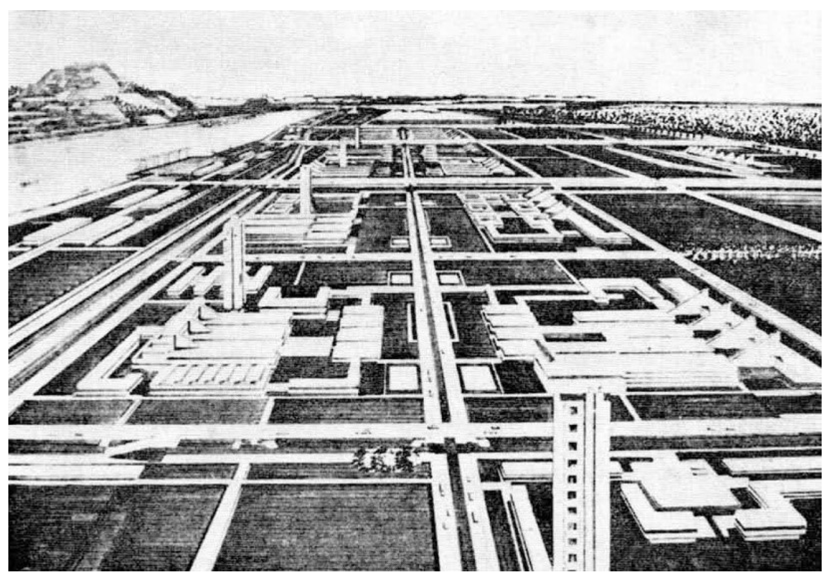
| 1958 | Program for new settlements within the Agricultural Combine | x | the concept of “a city that feeds”; the typical solutions of agricultural buildings | Establishment of the self-management planning | |||||
| Regulatory plan for the first region of the Danube–city—Belgrade on the left bank of the Danube | + | the concept of the “lamellar city” and Danube-city | |||||||
| Establishment of the Planning Directorate and the construction of Belgrade on the left bank of the Danube | x | establishment of the Self-Management Pyramid of the Combine; an autonomous planning organization, independent of the Urban Institute of Belgrade | |||||||
| 1966 | General Overview of the Master Plan of 1966 | + | determination of specific sites and urban conditions for current construction | ||||||
| 1968 | Regional Spatial Plan for the Danube Tourism Development | + | a system of focal points for tourism and recreation | ||||||
| Belgrade Urbanization Plan on the left bank of the Danube | + | detailed plans for seven PKB settlements | |||||||
| 1970 | Study on the Development of Belgrade’s economy and the possibilities for its integration into the global market | • | the recognition of opportunities and conditions for economic integration into the global market | Humanization of Environment | |||||
| Study “Environmental awareness and self-involvement of working people and citizens in protecting and improving the natural environment on the territory of Belgrade” | • | protection of the environment—humanization of production vs. humanization of environment | |||||||
| Establishment of the City Board of Environmental Protection | x | the promotion of an urban planning approach based on the “protective urbanism” concept | |||||||
| 1972 | Belgrade Landscape Plan | + | rediscovery of the quality and form of the natural landscape; | ||||||
| Belgrade Master Plan | + | the concept of “an archipelago of settlements in a sea of greenery” | |||||||
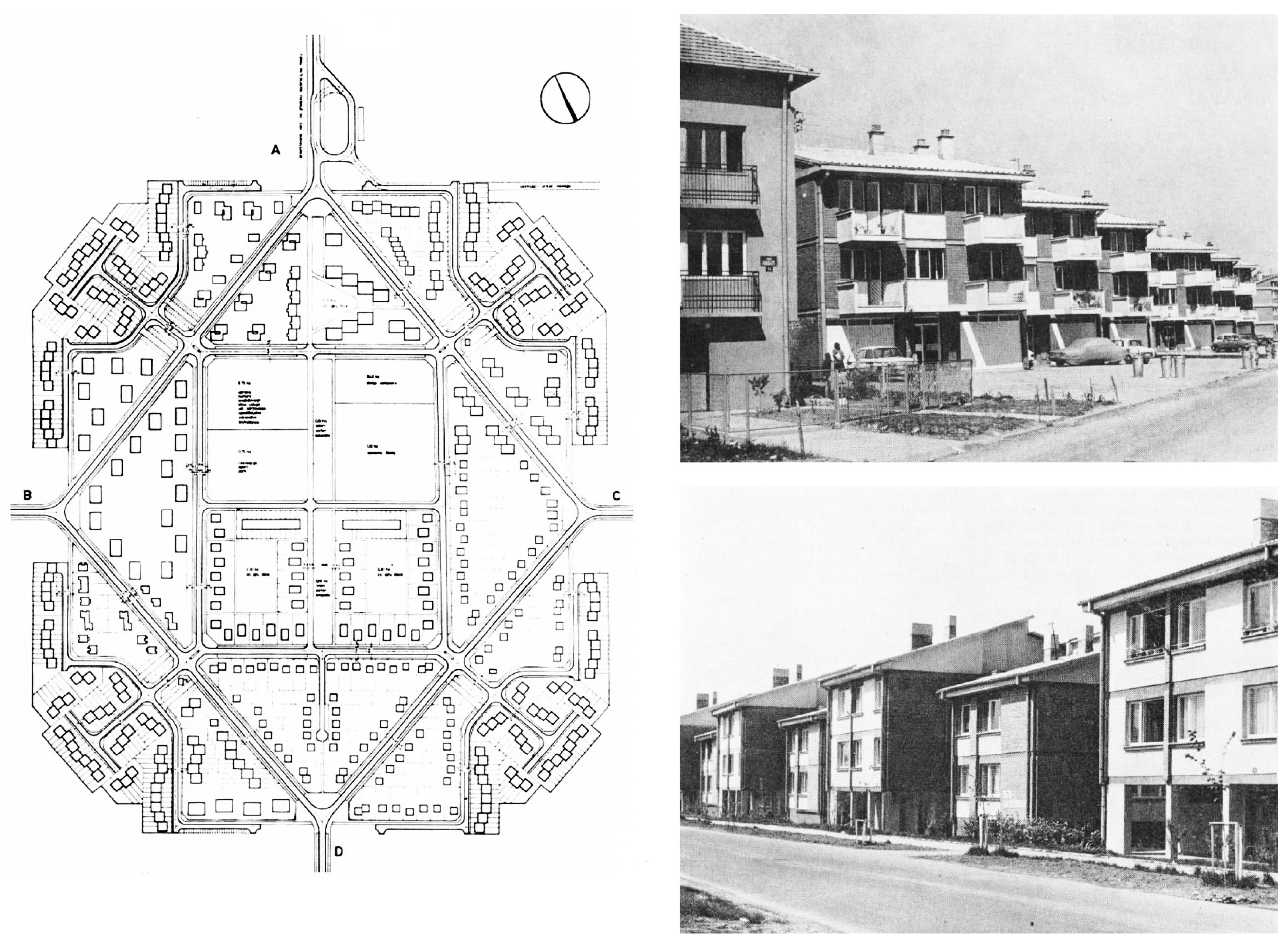
| 1973 | General Housing Plans for PKB settlements | + | the system of agro-industrial settlements in the form of “independent cells of local communities” | ||||||
| 1984 | Amendments to the Belgrade Master Plan until 2002 | + | the concept of connecting the city to the Danube river | Post-socialist Transition and Collapse of rhe Agricultural Combine | |||||
| 1995 | Pan-European Biological and Landscape Diversity Strategy PEBLDS | x | formation of the Pan-European Ecological Network (PEEN), which is composed of neighboring national ecological networks countries, in order to preserve long-term ecosystems, habitats and species of importance for protection at the European level | ||||||
| 2003 | Belgrade Master Plan until 2021 | + | identification of fixed elements of greenery and protective greenery systems | ||||||
| 2004 | Regional spatial plan of the administrative area of the city of Belgrade | + | directing development axes towards the territory of the left bank of the Danube and creating a new urban development center | ||||||
| 2010 | Regulation on the ecological network of the Republic of Serbia | x | the riverside of the Danube is defined as an ecological corridor of national and international importance | ||||||
| 2011 | EU strategy for the Danube region (Danube Strategy) | x | the issue of environmental protection and sustainable use of natural resources | ||||||
| Index of source type (I)/Clusters of sources | |||||||||
| + | Plan | • | Study | ⬥ | Program | ° | Policy/Strategy | x | Institution establishment |
| Settlement | Gross Area of Settlement (ha) | Gross Area of Residential Part of Settlement (ha) | Gross Area of Economic Part of Settlement (ha) | Number of Inhabitants | Population Density (inhabitants/ha) | |||||
|---|---|---|---|---|---|---|---|---|---|---|
| 1—Socialist period 2—Post-socialist period | 1 | 2 | 1 | 2 | 1 | 2 | 1 | 2 | 1 | 2 |
| Dunavac | 46.80 | 63.90 | 16.25 | 33.35 | 30.55 | 30.55 | 500 | 496 | 31 | 15 |
| Pionir | 63.10 | 66.20 | 22.40 | 23.10 | 40.70 | 43.10 | 1000 | 856 | 45 | 37 |
| Partizanski prelaz | 62.00 | 65.10 | 22.40 | 25.40 | 39.60 | 39.70 | 1200 | 978 | 54 | 39 |
| Padinska skela | 297.80 | 386.40 | 107.80 | 176.40 | 184.00 | 210.00 | 4500 | 6301 | 42 | 36 |
| Kovilovo | 57.10 | 59.20 | 26.70 | 28.60 | 30.40 | 30.60 | 1200 | 920 | 45 | 32 |
| Lepušnica | 75.50 | 77.40 | 35.00 | 36.20 | 40.50 | 41.20 | 1500 | 1143 | 43 | 32 |
| Mladost | 76.80 | 78.30 | 25.80 | 25.90 | 51.00 | 52.40 | 1200 | 841 | 47 | 32 |
Publisher’s Note: MDPI stays neutral with regard to jurisdictional claims in published maps and institutional affiliations. |
© 2020 by the authors. Licensee MDPI, Basel, Switzerland. This article is an open access article distributed under the terms and conditions of the Creative Commons Attribution (CC BY) license (http://creativecommons.org/licenses/by/4.0/).
Share and Cite
Djokić, V.; Milovanović, A.; Ristić Trajković, J. The Textuality of the Modernist Rural Landscape: Belgrade Agricultural Combine (PKB) as a Driver of the Urban Development of Third Belgrade. Land 2020, 9, 452. https://doi.org/10.3390/land9110452
Djokić V, Milovanović A, Ristić Trajković J. The Textuality of the Modernist Rural Landscape: Belgrade Agricultural Combine (PKB) as a Driver of the Urban Development of Third Belgrade. Land. 2020; 9(11):452. https://doi.org/10.3390/land9110452
Chicago/Turabian StyleDjokić, Vladan, Aleksandra Milovanović, and Jelena Ristić Trajković. 2020. "The Textuality of the Modernist Rural Landscape: Belgrade Agricultural Combine (PKB) as a Driver of the Urban Development of Third Belgrade" Land 9, no. 11: 452. https://doi.org/10.3390/land9110452