A Socio-Spatial Analysis of Land Use Dynamics and Process of Land Intervention in the Peri-Urban Areas of Bahir Dar City


Abstract
1. Introduction
2. Peri-Urban Land Use Dynamics
2.1. Concept and Implications
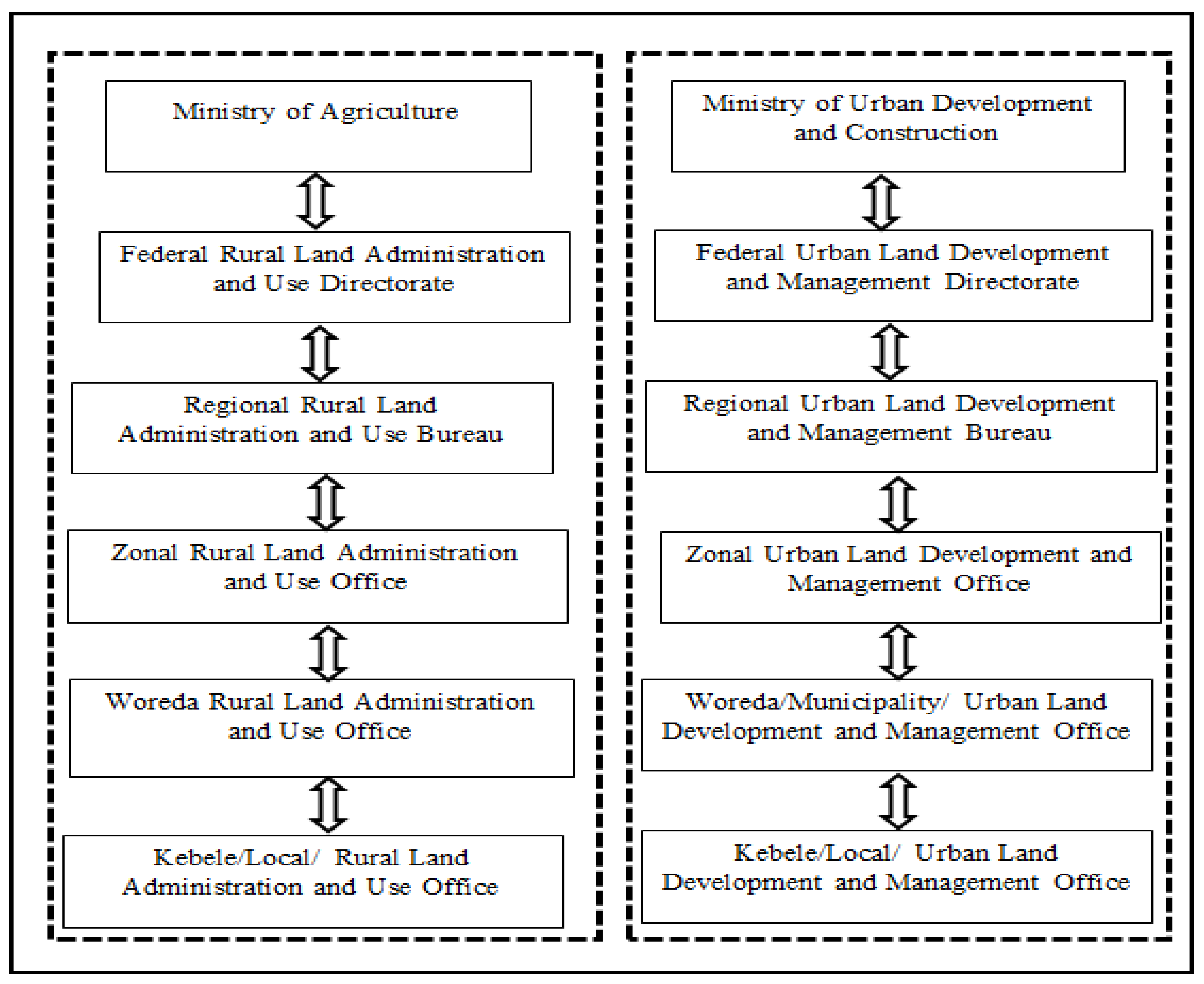
2.2. Legislative Framework and Instruments of Land Interventions in Ethiopia
3. Materials and Methods
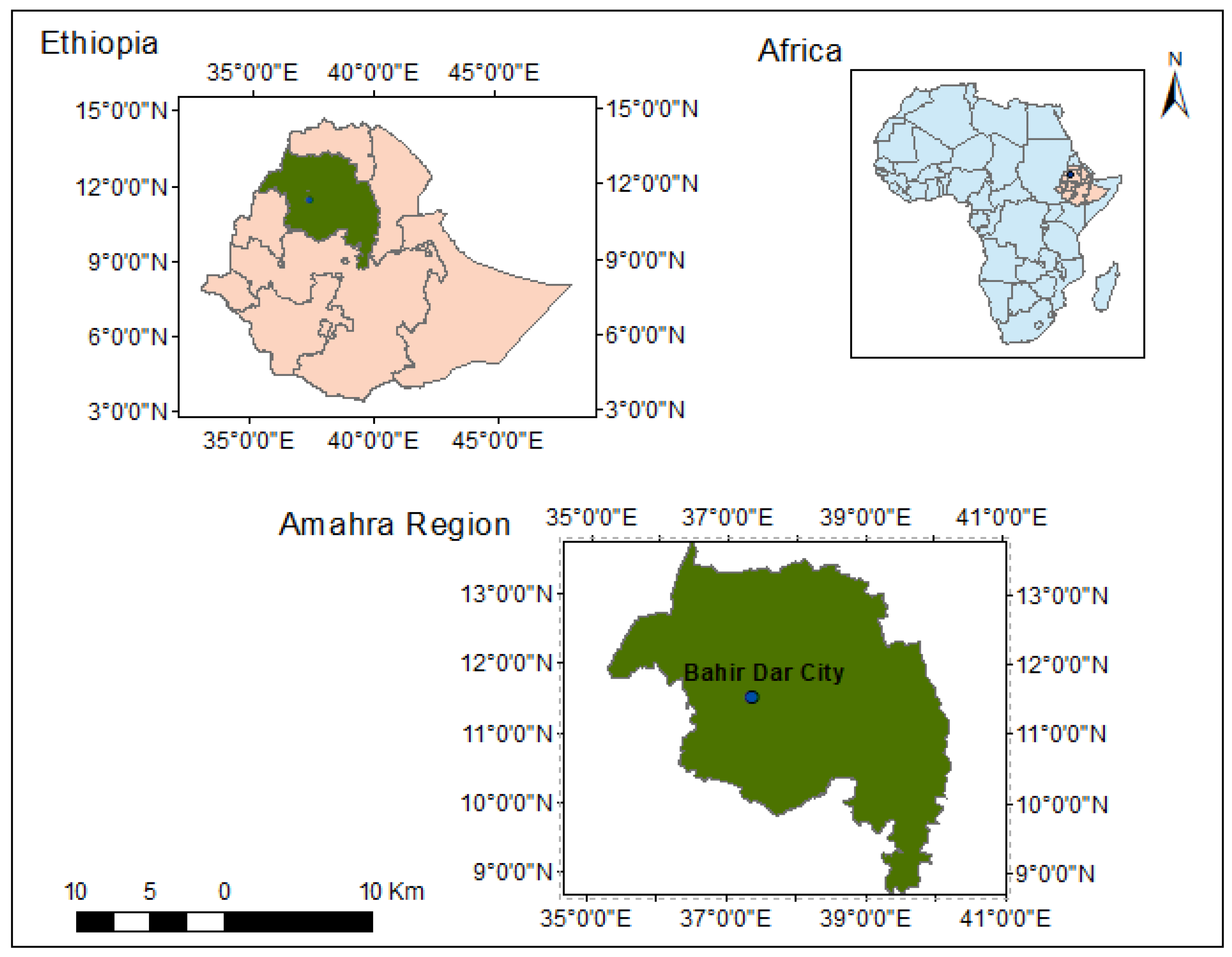
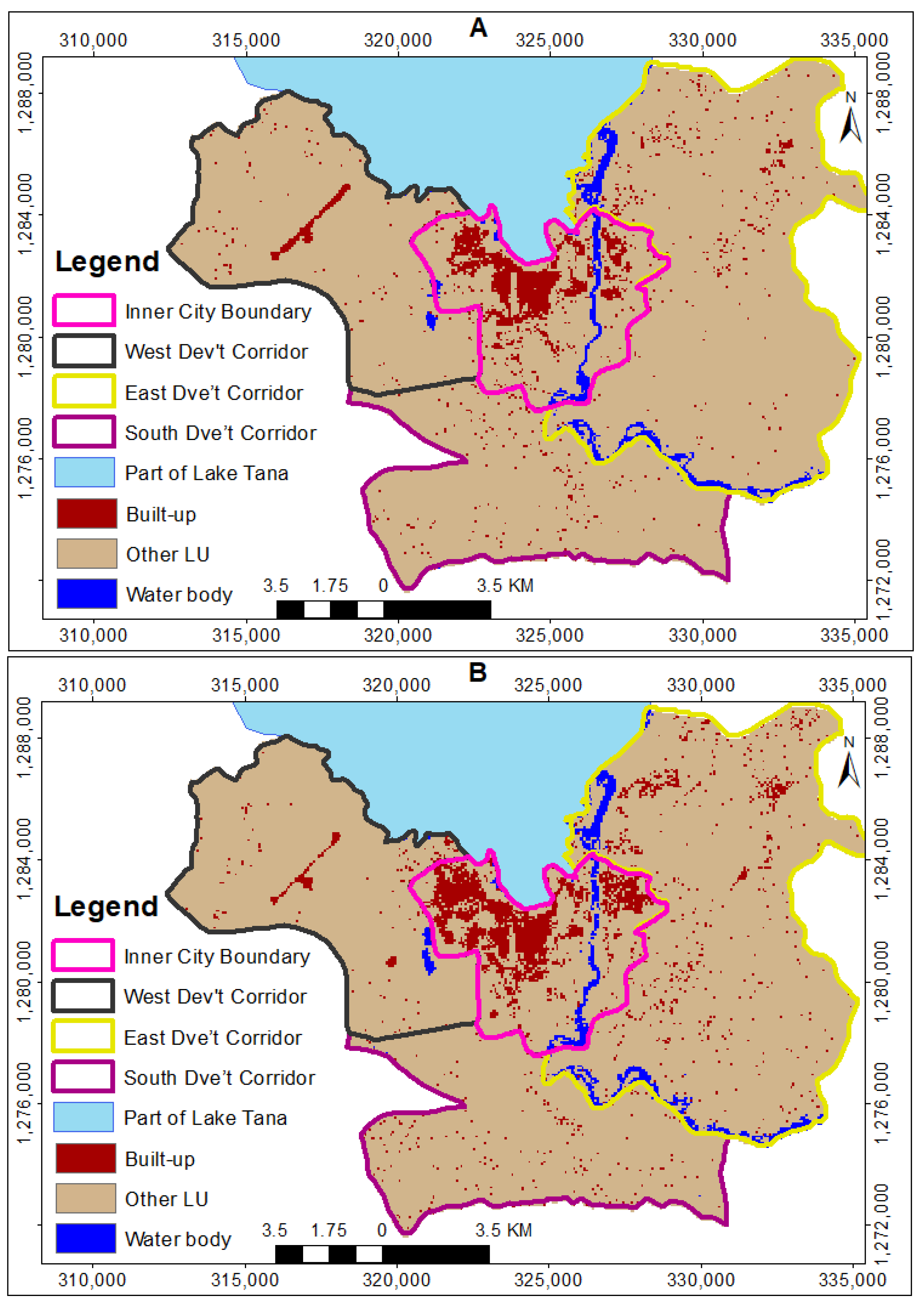
3.1. Study Area
3.2. Research Approach and Design
3.3. Unit of Analysis and Sampling Techniques
3.4. Methods of Data Collection
3.4.1. Socio-Economic Data
3.4.2. Spatial Data
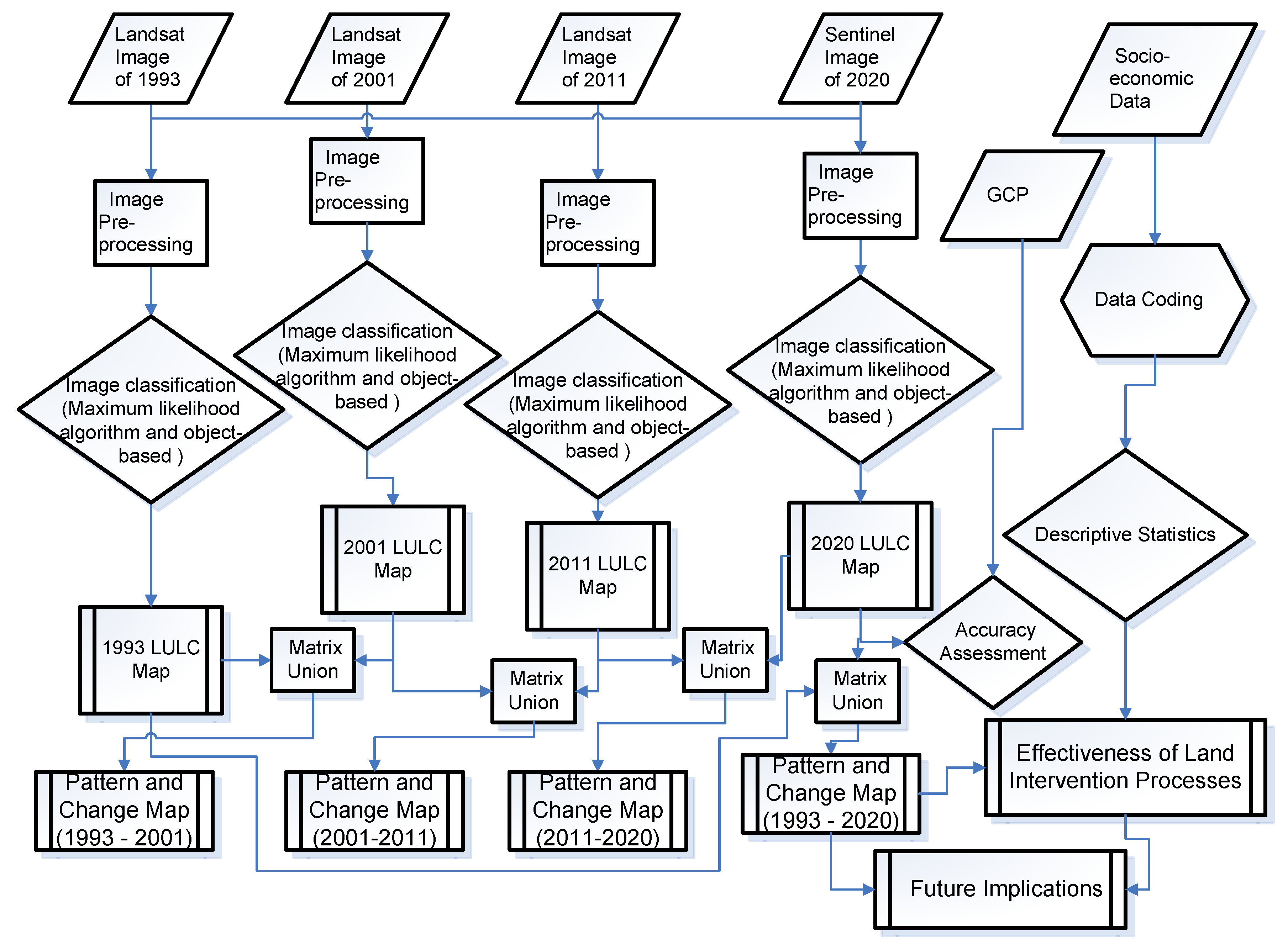
3.5. Data Analysis
4. Result and Discussions
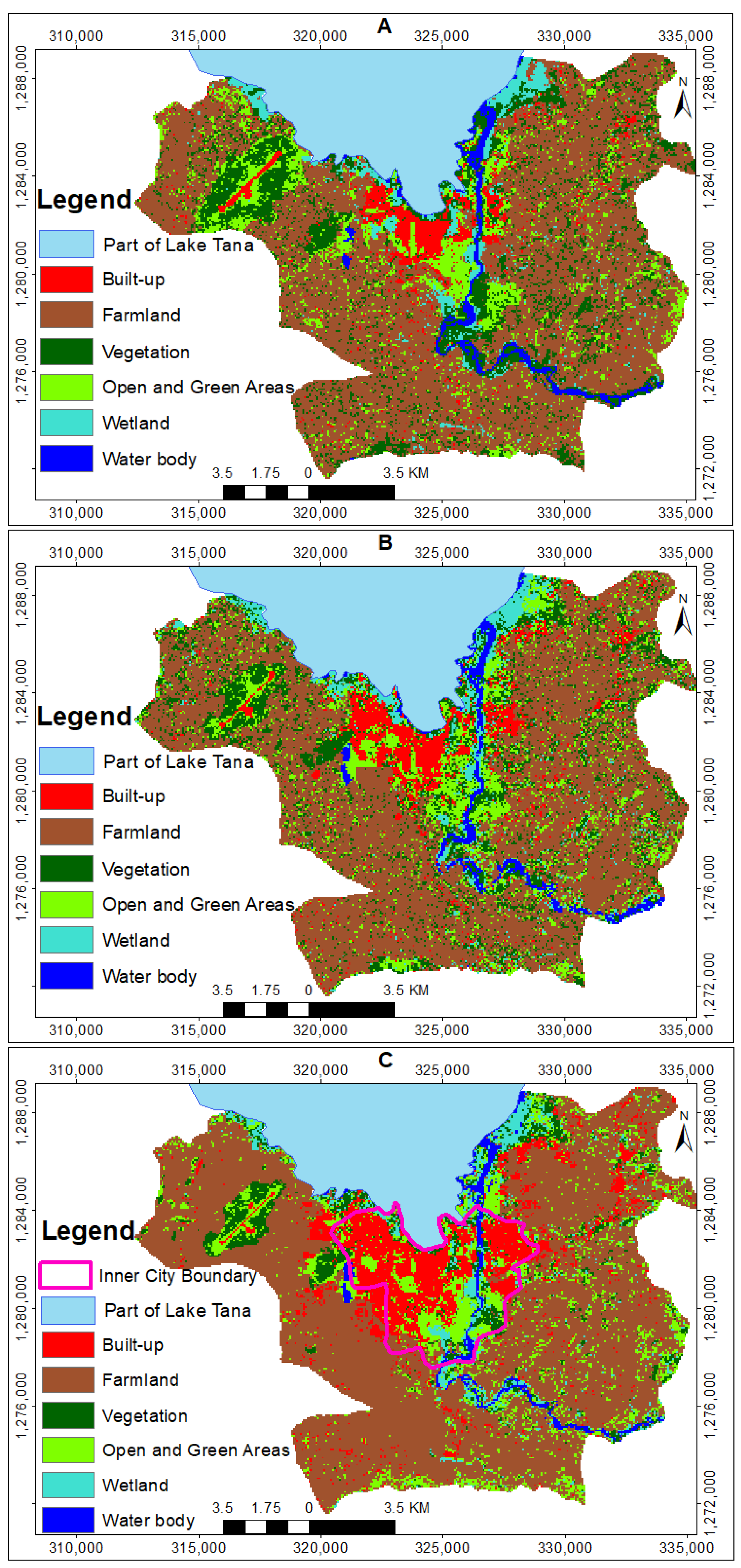
4.1. Patterns and Spatial Expansion of Built-Up Areas (1993 to 2020)
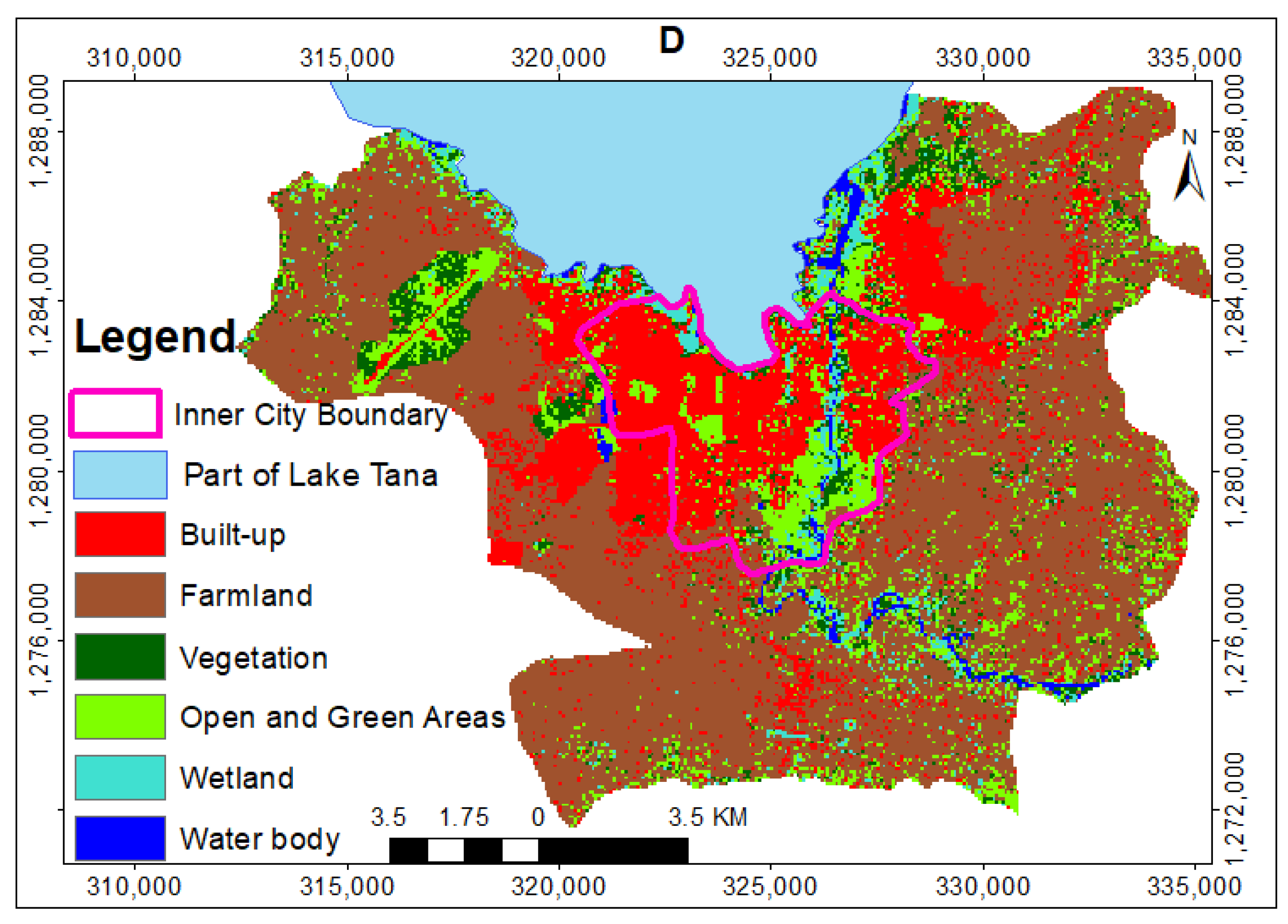
4.2. The Spatial Dynamics of Peri-Urban Land
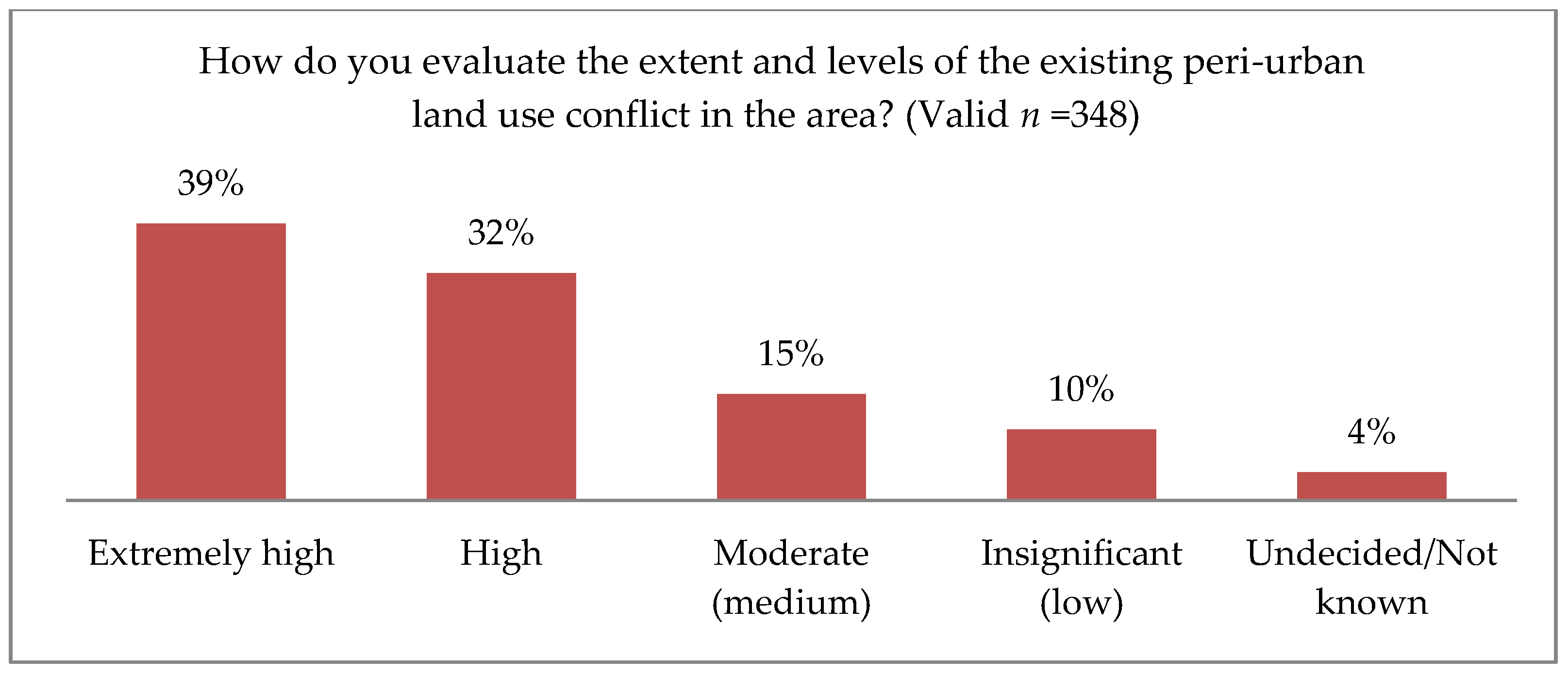
4.3. Land Intervention Process and Its Effectiveness for Governing Land Use Dynamics
5. Conclusions
Author Contributions
Funding
Acknowledgments
Conflicts of Interest
References
- Agunbiade, M.E.; Rajabifard, A.; Bennett, R. The dynamics of city growth and the impact on urban land policies in developing countries. Int. J. Urban Sustain. Dev. 2012, 4, 146–165. [Google Scholar] [CrossRef]
- Alemie, B.; Zevenbergen, J.; Bennett, R. Assessing Land Governance in Ethiopian Cities (2002–2011): Lessons for the Implementation of the 2011 Urban Land Management Policy. In Proceedings of the From the Wisdom of the Ages to the Challenges of the Modern World, FIG Working Week, Sofia, Bulgaria, 17–21 May 2015. [Google Scholar]
- UN. Realizing the Future We Want for All: Report to the Secretary-General on the UN Development Agenda; UN: New York, NY, USA, 2012; Available online: https://www.un.org/millenniumgoals/pdf/Post_2015_UNTTreport.pdf (accessed on 13 October 2019).
- Von Der Dunk, A.; Grêt-Regamey, A.; Dalang, T.; Hersperger, A.M. Defining a typology of peri-urban land-use conflicts—A case study from Switzerland. Landsc. Urban Plan. 2011, 101, 149–156. [Google Scholar] [CrossRef]
- Cohen, B. Urbanization in developing countries: Current trends, future projections, and key challenges for sustainability. Technol. Soc. 2006, 28, 63–80. [Google Scholar] [CrossRef]
- UN-HABITAT. State of the World Cities 2010/2011: Bridging the Urban Divide; UN-Habitat: Nairobi, Kenya, 2010; Available online: https://sustainabledevelopment.un.org/content/documents/11143016_alt.pdf (accessed on 12 March 2018).
- Nilsson, K.; Sick, T.; Aalbers, C.; Bell, S.; Boitier, B.; Chery, J.; Fertner, C.; Groschowski, M.; Haase, D.; Loibl, W.; et al. Strategies for Sustainable Urban Development and Urban-Rural Linkages. Eur. J. Spat. Dev. 2014, 4, 1–26. [Google Scholar]
- Eppler, U.; Fritsche, U.; Laaks, S. Urban-Rural Linkages and Global Sustainable Land Use; GLOBALANDS Issue Paper; International Institute for Sustainability Analysis and Strategy (IINAS): Berlin, Germany; Darmstadt, Germany, 2015. [Google Scholar]
- UN. The 2018 Revision of World Urbanization Prospects: United Nation Population Division; Department of Economic and Social Affairs, United Nations: New York, NY, USA, 2018. [Google Scholar]
- Freire, M.E. Urbanization and Green Growth in Africa: Green Growth Series Report No. 1. Available online: https://www.greengrowthknowledge.org/research/urbanization-and-green-growth-africa2013 (accessed on 10 July 2020).
- Don, O. Regional Overview of the Status of Urban Planning and Planning Practice in Anglophone (Sub-Saharan) African Countries, Regional Study Prepared for Revisiting Urban Planning: Global Report on Human Settlements; UN-Habitat: Nairobi, Kenya, 2009. [Google Scholar]
- Williamson, I.; Enemark, S.; Wallace, J.; Rajabifard, A. Land Administration for Sustainable Development; Esri Press: Redlands, CA, USA, 2010; p. 506. [Google Scholar]
- EMoUDHC. National Report on Housing and Sustainable Urban Development; Ethiopian Ministry of Urban Development, Housing and Construction: Addis Ababa, Ethiopia, 2014; Available online: http://habitat3.org/wp-content/uploads/National-Report-Africa-Ethiopia-Final-in-English.pdf (accessed on 1 July 2018).
- CSA. The Federal Democratic Republic of Ethiopia Central Statistical Agency Report on Population Projection of Ethiopia; CSA: Addis Ababa, Ethiopia, 2013. Available online: http://www.csa.gov.et/ (accessed on 11 November 2018).
- Fenta, A.A.; Yasuda, H.; Haregeweyn, N.; Belay, A.S.; Hadush, Z.; Gebremedhin, M.A.; Mekonnen, G. The dynamics of urban expansion and land use/land cover changes using remote sensing and spatial metrics: The case of Mekelle City of northern Ethiopia. Int. J. Remote Sens. 2017, 38, 4107–4129. [Google Scholar] [CrossRef]
- Gashu, K.; Gebre-Egziabher, T. Spatiotemporal trends of urban land use/land cover and green infrastructure change in two Ethiopian cities: Bahir Dar and Hawassa. Environ. Syst. Res. 2018, 7, 8. [Google Scholar] [CrossRef]
- Manikandan, S. Spatial and Temporal Dynamics of Urban Sprawl Using Multi- temporal Images and Relative Shannon Entropy Model in Adama, Ethiopia. J. Adv. Res. Geo Sci. Remote Sens. 2019, 5, 48–57. [Google Scholar] [CrossRef]
- EMoUDH; World-Bank. Ethiopia Urbanization Review: Urban Institutions for a Middle-Income Ethiopia; EMoUDH, World-Bank: Addis Ababa, Ethiopia, 2015; Available online: http://documents.worldbank.org/curated/en/543201468000586809/pdf/100238-WP-EUR-Box393221B-PUBLIC.pdf (accessed on 12 October 2019).
- CSA. Federal Democratic Republic of Ethiopia Central Statistical Agency: Population Census of Ethiopia; CSA: Addis Ababa, Ethiopia, 2007. Available online: http://www.csa.gov.et/ (accessed on 11 November 2018).
- Wubneh, M. Policies and praxis of land acquisition, use, and development in Ethiopia. Land Use Policy 2018, 73, 170–183. [Google Scholar] [CrossRef]
- Wubie, A.M.; De Vries, W.T.; Alemie, B.K. Synthesizing the dilemmas and prospects for a peri-urban land use management framework: Evidence from Ethiopia. Land Use Policy 2021, 100, 105122. [Google Scholar] [CrossRef]
- Adam, A.G. Informal settlements in the peri-urban areas of Bahir Dar, Ethiopia: An institutional analysis. Habitat Int. 2014, 43, 90–97. [Google Scholar] [CrossRef]
- Fetene, M.W.; Serbeh-Yiadom, K.; Asfaw, M. A Critical Review of the Application of Planning Standards and Norms in the Planning of Bahir Dar and Hawassa Cities, Ethiopia. Dev. Ctry. Stud. 2014, 4, 66–79. [Google Scholar]
- Dube, E.E. Urban planning and land management challenges in emerging towns of ethiopia: The case of arba minch. J. Urban Environ. Eng. 2013, 7, 340–348. [Google Scholar] [CrossRef]
- Adam, A.G. Peri-Urban Land Tenure in Ethiopia. Ph.D. Thesis, Royal Institute of Technology (KTH), Stockholm, Sweden, 2014. [Google Scholar]
- WHO; UN-Habitat. Global Report on Urban Health: Equitable, Healthier Cities for Sustainable Development; WHO Library Cataloguing-in-Publication Data; WHO and UN-Habitat: Geneva, Switzerland, 2016; ISBN 978 92 4 1565271. [Google Scholar]
- Holden, S.T.; Bezu, S. Preferences for land sales legalization and land values in Ethiopia. Land Use Policy 2016, 52, 410–421. [Google Scholar] [CrossRef]
- Bennett, R.M.; Alemie, B.K. Fit-for-purpose land administration: Lessons from urban and rural Ethiopia. Surv. Rev. 2016, 48, 11–20. [Google Scholar] [CrossRef]
- Enemark, S. Building Land Information Policies. In Proceedings of the UN, FIG, PC IDEA Inter-regional Special Forum on The Building of Land Information Policies in the Americas, Aguascalientes, Mexico, 26–27 October 2004. [Google Scholar]
- Adam, A.G. Land Tenure in the Changing Peri-Urban Areas of Ethiopia: The Case of Bahir Dar City. Int. J. Urban Reg. Res. 2014, 38, 1970–1984. [Google Scholar] [CrossRef]
- Debolini, M.; Valette, E.; François, M.; Chéry, J.-P. Mapping land use competition in the rural–urban fringe and future perspectives on land policies: A case study of Meknès (Morocco). Land Use Policy 2015, 47, 373–381. [Google Scholar] [CrossRef]
- Ruoso, L.-E.; Plant, R. A politics of place framework for unravelling peri-urban conflict: An example of peri-urban Sydney, Australia. J. Urban Manag. 2018, 7, 57–69. [Google Scholar] [CrossRef]
- Gomes, S.L.; Hermans, L.M. Institutional function and urbanization in Bangladesh: How peri-urban communities respond to changing environments. Land Use Policy 2018, 79, 932–941. [Google Scholar] [CrossRef]
- Admasu, T.G. Urban land use dynamics, the nexus between land use pattern and its challenges: The case of Hawassa city, Southern Ethiopia. Land Use Policy 2015, 45, 159–175. [Google Scholar] [CrossRef]
- Admasu, W.F.; Van Passel, S.; Minale, A.S.; Tsegaye, E.A.; Azadi, H.; Nyssen, J. Take out the farmer: An economic assessment of land expropriation for urban expansion in Bahir Dar, Northwest Ethiopia. Land Use Policy 2019, 87, 104038. [Google Scholar] [CrossRef]
- Haregeweyn, N.; Fikadu, G.; Tsunekawa, A.; Tsubo, M.; Meshesha, D.T. The dynamics of urban expansion and its impacts on land use/land cover change and small-scale farmers living near the urban fringe: A case study of Bahir Dar, Ethiopia. Landsc. Urban Plan. 2012, 106, 149–157. [Google Scholar] [CrossRef]
- UN-GGIM. UN-GGIM (UN-Global Geospatial Information Management) Inter-Agency and Expert Group on the Sustainable Development Goal Indicators (IAEG-SDGS) Working Group Report on Geospatial Information. 2013. Available online: http://ggim.un.org/UNGGIM-wg6/ (accessed on 14 March 2018).
- McCall, M.K.; Dunn, C.E. Geo-information tools for participatory spatial planning: Fulfilling the criteria for ‘good’ governance? Geoforum 2012, 43, 81–94. [Google Scholar] [CrossRef]
- Yeh, A. Decision Support with Geographic Information Systems. In Decision Support for Sustainable Development: A Resource Book of Methods and Applications; Kersten, G., Mikolajuk, Z., Yeh, A., Eds.; International Development Research Centre, Kluwer Academic Publishers: Norwell, MA, USA, 2000; pp. 53–70. [Google Scholar]
- Navarro-Cerrillo, R.M.; Palacios-Rodríguez, G.; Rumbao, I.C.; Lara, M.; Bonet, F.J.; Mesas-Carrascosa, F. Modeling Major Rural Land-Use Changes Using the GIS-Based Cellular Automata Metronamica Model: The Case of Andalusia (Southern Spain). ISPRS Int. J. Geo-Inf. 2020, 9, 458. [Google Scholar] [CrossRef]
- Tuladhar, A. Innovative Uses of Remote Sensing Image for Pro Poor Land Management. In Land Administration: The Path to Tenure Security, Poverty Alleviation and Sustainable Development: Land Administration seSsions ITC Lustrum Conference, Spatial Information for Civil Society, Capacity Building for the International Geo-Information Society; Kalf, J., Ed.; International Institute for Geo-Information Science and Earth Observation: Enschede, The Netherlands, 2006; pp. 81–96. [Google Scholar]
- Kansu, O.; Gazioglu, S. The Availability of Satellite Image data in digital Cadastral Map Production. In Proceedings of the Shaping the Change, Munich, Germany, 8–13 October 2006. [Google Scholar]
- Ruiz-Tagle, J. A Theory of Socio-spatial Integration: Problems, Policies and Concepts from a US Perspective. Int. J. Urban Reg. Res. 2012, 37, 388–408. [Google Scholar] [CrossRef]
- Pribadi, D.O.; Pauleit, S. The dynamics of peri-urban agriculture during rapid urbanization of Jabodetabek Metropolitan Area. Land Use Policy 2015, 48, 13–24. [Google Scholar] [CrossRef]
- Tacoli, C. The links between urban and rural development. Environ. Urban 2003, 15, 1–12. [Google Scholar] [CrossRef]
- Sapena, M.; Ruiz, L.A.; Taubenböck, H. Analyzing Links between Spatio-Temporal Metrics of Built-Up Areas and Socio-Economic Indicators on a Semi-Global Scale. ISPRS Int. J. Geo-Inf. 2020, 9, 436. [Google Scholar] [CrossRef]
- Wei, Y.D.; Ye, X. Urbanization, urban land expansion and environmental change in China. Stoch. Environ. Res. Risk Assess. 2014, 28, 757–765. [Google Scholar] [CrossRef]
- FIG-Commission-3. Rapid Urbanization and Mega Cities: The Need for Spatial Information Management; International Federation of Surveyors (FIG): Copenhagen, Denmark, 2010. [Google Scholar]
- Floater, G.; Rode, P.; Friedel, B.; Robert, A. Steering Urban Growth: Governance, Policy and Finance; London School of Economics and Political Science: London, UK, 2014. [Google Scholar]
- Banzhaf, E.; Kabisch, S.; Knapp, S.; Rink, D.; Wolff, M.; Kindler, A. Integrated research on land-use changes in the face of urban transformations—An analytic framework for further studies. Land Use Policy 2017, 60, 403–407. [Google Scholar] [CrossRef]
- Enoguanbhor, E.C.; Gollnow, F.; Nielsen, J.O.; Lakes, T.; Walker, B.B. Land Cover Change in the Abuja City-Region, Nigeria: Integrating GIS and Remotely Sensed Data to Support Land Use Planning. Sustainability 2019, 11, 1313. [Google Scholar] [CrossRef]
- Hu, Y.; Kong, X.; Zheng, J.; Sun, J.; Wang, L.; Min, M. Urban Expansion and Farmland Loss in Beijing during 1980–2015. Sustainability 2018, 10, 3927. [Google Scholar] [CrossRef]
- Robinson, G.M.; Song, B. Transforming the Peri-Urban Fringe in China: The Example of Xi’an-Xianyang. Sustainability 2018, 10, 3932. [Google Scholar] [CrossRef]
- Medeiros, E.; Van Der Zwet, A. Sustainable and Integrated Urban Planning and Governance in Metropolitan and Medium-Sized Cities. Sustainability 2020, 12, 5976. [Google Scholar] [CrossRef]
- UN-WESS. Sustainable Development Challenges; United Nations publication: New York, NY, USA, 2013; Available online: https://sustainabledevelopment.un.org/content/documents/2843WESS2013.pdf (accessed on 12 November 2018).
- Tian, Y.; Wang, L. The Effect of Urban-Suburban Interaction on Urbanization and Suburban Ecological Security: A Case Study of Suburban Wuhan, Central China. Sustainability 2020, 12, 1600. [Google Scholar] [CrossRef]
- Qiu, R.; Xu, W. Modes of land development in Shanghai. Land Use Policy 2017, 61, 475–486. [Google Scholar] [CrossRef]
- UNPD. World Population Prospects the 2010 Revision; United Nations: New York, NY, USA, 2011; Volume I. [Google Scholar]
- UN-Habitat. The State of African Cities: Re-Imagining Sustainable Urban Transitions; UN-Habitat: Nairobi, Kenya, 2014. [Google Scholar]
- Karg, H.; Hologa, R.; Schlesinger, J.; Drescher, A.; Kranjac-Berisavljevic, G.; Glaser, R. Classifying and Mapping Periurban Areas of Rapidly Growing Medium-Sized Sub-Saharan African Cities: A Multi-Method Approach Applied to Tamale, Ghana. Land 2019, 8, 40. [Google Scholar] [CrossRef]
- Wu, Y.; Zhang, X.; Shen, L. The impact of urbanization policy on land use change: A scenario analysis. Cities 2011, 28, 147–159. [Google Scholar] [CrossRef]
- Gwan, A.S.; Kimengsi, J.N. Urban Expansion and the Dynamics of Farmers’ Livelihoods: Evidence from Bamenda, Cameroon. Sustainability 2020, 12, 5788. [Google Scholar] [CrossRef]
- Lwasa, S. Managing African Urbanization in the Context of Environmental Change. Interdisciplina 2014, 2, 263–280. [Google Scholar] [CrossRef]
- Wu, Y.; Tao, Y.; Yang, G.; Ou, W.; Pueppke, S.; Sun, X.; Chen, G.; Tao, Q. Impact of land use change on multiple ecosystem services in the rapidly urbanizing Kunshan City of China: Past trajectories and future projections. Land Use Policy 2019, 85, 419–427. [Google Scholar] [CrossRef]
- Akubia, J.E.K.; Ahmed, A.; Bruns, A. Assessing How Land-Cover Change Associated with Urbanisation Affects Ecological Sustainability in the Greater Accra Metropolitan Area, Ghana. Land 2020, 9, 182. [Google Scholar] [CrossRef]
- Lombard, M. Land conflict in peri-urban areas: Exploring the effects of land reform on informal settlement in Mexico. Urban Stud. 2016, 53, 2700–2720. [Google Scholar] [CrossRef]
- EU. Land Policy Guidelines: Guidelines for Support to Land Policy Design and Land Policy Reform Processes in Developing Countries; European Union: Brussels, Belgium, 2004. [Google Scholar]
- Barnard, S.; Elliott, M. The 10-tenets of adaptive management and sustainability: An holistic framework for understanding and managing the socio-ecological system. Environ. Sci. Policy 2015, 51, 181–191. [Google Scholar] [CrossRef]
- FDRE-Urban-Land-Lease-Proc. Federal Democratic Republic of Ethiopia Urban Lands Lease Holding Proclamation No. 721/2011; Federal Negarit Gazette: Addis Ababa, Ethiopia, 2011. [Google Scholar]
- Adam, A.G. Peri-urbanization and New Built-up Property Formation Process in the Peri-urban Areas of Ethiopia. JLAEA 2015, 3, 328–345. [Google Scholar]
- Rural-Land-Administration-and-Use-Proc. Federal Democratic Republic of Ethiopia Rural Land Administration and Land Use Proclamation No. 456/2005; Federal Negarit Gazette: Addis Ababa, Ethiopia, 2005. [Google Scholar]
- FDRE-Constitution. Constitution of Federal Democratic Republic of Ethiopia, Proclamation No.1/1995; Fed. Neg. Gaz. 1st year No.1; Federal Negarit Gazetta: Addis Ababa, Ethiopia, 1995. [Google Scholar]
- Ambaye, D.W. Land Rights and Expropriation in Ethiopia; Springer International Publishing: Cham, Switzerland, 2015. [Google Scholar] [CrossRef]
- Meteorological-Agency. Report of Temperature and Rainfall Data; National Meteorological Agency of Ethiopia, Bahir Dar Branch: Bahir Dar, Ethiopia, 2019.
- FAO. World Soil Database; Food and Agriculture Organization of the United Nations: Rome, Italy, 1984. [Google Scholar]
- IMF. Country Report No. 20/29 of the Federal Democratic Republic of Ethiopia; International Monetary Fund: Washington, DC, USA, 2020; Available online: http://www.imf.org (accessed on 27 October 2020).
- Alemie, B.K.; Bennett, R.; Zevenbergen, J. A socio-spatial methodology for evaluating urban land governance: The case of informal settlements. J. Spat. Sci. 2015, 60, 1–21. [Google Scholar] [CrossRef]
- Cochran, W.G. Sampling Techniques, 2nd ed.; John Wiley and Sons, Inc.: New York, NY, USA, 1963. [Google Scholar]
- Yamane, T. Statistics: An Introductory Analysis, 2nd ed.; Harper and Row: New York, NY, USA, 1967. [Google Scholar]
- Israel, G. Determining Sample Size; Institute of Food and Agricultural science, University of Florida: Gainesville, FL, USA, 2003. [Google Scholar]
- Krueger, R.; Casey, M. Focus Groups: A Practical Guide for Applied Research, 5th ed.; Sage Publications Inc.: Thousand Oaks, CA, USA, 2014. [Google Scholar]
- Rabiee, F. Focus-group interview and data analysis. Proc. Nutr. Soc. 2004, 63, 655–660. [Google Scholar] [CrossRef]
- Lillesand, T.; Kiefer, R. Remote Sensing and Image Interpretation, 4th ed.; Wiley and Sons: New York, NY, USA, 2000. [Google Scholar]
- Abburu, S.; Golla, S.B. Satellite Image Classification Methods and Techniques: A Review. Int. J. Comput. Appl. 2015, 119, 20–25. [Google Scholar] [CrossRef]
- FAO. AFRICOVER Land Cover Classification; Food and Agriculture Organisation of the United Nations: Rome, Italy, 1997; Available online: http://www.fao.org/3/a-bd854e.pdf (accessed on 10 August 2019).
- Jansen, L.J.M. Harmonization of land use class sets to facilitate compatibility and comparability of data across space and time. J. Land Use Sci. 2006, 1, 127–156. [Google Scholar] [CrossRef]
- Aksoy, S. Spatial Techniques for Image Classification. Image Process. Remote Sens. 2008, 1–28. Available online: https://www.researchgate.net/publication/228937024 (accessed on 27 October 2020). [CrossRef]
- Congalton, R.G. A review of assessing the accuracy of classifications of remotely sensed data. Remote Sens. Environ. 1991, 37, 35–46. [Google Scholar] [CrossRef]
- Rovai, A.; Baker, J.; Ponton, M. Social Science Research Design and Statistics: A Practitioner’s Guide to Research Methods and IBM SPSS Analysis, 2nd ed.; Watertree Press: Chesapeake, VA, USA, 2014. [Google Scholar]
- Mawenda, J.; Watanabe, T.; Avtar, R. An Analysis of Urban Land Use/Land Cover Changes in Blantyre City, Southern Malawi (1994–2018). Sustainability 2020, 12, 2377. [Google Scholar] [CrossRef]
- Tian, Y. Mapping Suburbs Based on Spatial Interactions and Effect Analysis on Ecological Landscape Change: A Case Study of Jiangsu Province from 1998 to 2018, Eastern China. Land 2020, 9, 159. [Google Scholar] [CrossRef]
- Kosa, A.; Juhar, N.; Kute, I.M. Urbanization in Ethiopia: Expropriation Process and Rehabilitation Mechanism of Evicted Peri-Urban Farmers (Policies and Practices). Int. J. Econ. Manag. Sci. 2017, 6, 1–9. [Google Scholar] [CrossRef]
- Deininger, K.; Selod, H.; Burns, A. The Land Governance Assessment Framework: Identifying and Monitoring Good Practice in the Land Sector; World Bank: Washington, DC, USA, 2012. [Google Scholar]


| Major Regional Cities | Year | Urban Population Change (%) (2007–2017) | |
|---|---|---|---|
| 2007 | 2017 | ||
| Bahir Dar | 180,174 | 313,997 | 87.14 |
| Hawassa | 157,879 | 335,598 | 106.28 |
| Adama | 220,212 | 355,475 | 80.70 |
| Mekelle | - | 358,529 | - |
| Land Use/Land Cover Classes | Description |
|---|---|
| Built-ups | Areas that have an artificial cover/uses resulting from human activities such as constructions of all kind, urban fabric, industrial, commercial, residential, transportation units and other construction sites |
| Farmlands | Areas that are used for crop cultivation and other heterogeneous agricultural/farming areas |
| Vegetation | Areas that have a vegetative cover consisting of woody, trees, shrub or herbaceous, sparse forest and vegetation association |
| Open and green areas | All open spaces with little or sparse vegetation, including artificially vegetated green areas |
| Wetlands | Waterlogged ecosystem/areas either permanently or seasonally |
| water bodies | Areas that are covered by lakes, ponds, and rivers |
| Developmental Corridors/Peri-Urban Areas | Spatial Expansion of Built-Up Areas in ha | |||
|---|---|---|---|---|
| 1993–2001 | 2001–2011 | 2011–2020 | 1993–2020 | |
| Within the inner city boundary | 260.7 | 640 | 234.2 | 1134.9 |
| Towards West development corridor | 16 | 297.5 | 632.2 | 945.7 |
| Towards East development corridor | 155 | 258.9 | 751.1 | 1165.1 |
| Towards South development corridor | 21.5 | 32 | 265 | 318.5 |
| Total | 453.2 | 1228.4 | 1882.5 | 3564.2 |
| Average annual expansion rate (%) | 5.01 | 7.75 | 7.44 | 6.73 |
| LULC | Spatial Change in ha | |||
|---|---|---|---|---|
| 1993–2001 | 2001–2011 | 2011–2020 | 1993–2020 | |
| Built-ups | 453.2 | 1228.4 | 1882.5 | 3564.2 |
| Farmland | −247.9 | −495.3 | −848.7 | −1591.9 |
| Vegetation | −112.2 | −392.4 | −544.4 | −1049 |
| Open and green areas | −95.8 | −311.1 | −319.2 | −726 |
| Wetlands | 10.8 | −19.2 | −93.4 | −101.8 |
| Water body | −8.1 | −10.4 | −76.8 | −95.5 |
| Response | How Do You Evaluate the Effectiveness of the Existing LUP or the Actual Land Intervention Practice for Governing the Rate and Extent of Unwanted Land Use Dynamics in Peri-Urban Areas of the City? (Valid n = 348) | How Do You Evaluate the Effectiveness of the Existing LUP or Actual Land Intervention Practice for Reducing the Rate and Extents of Peri-Urban Land Use Conflict? (Valid n = 348) | |||
|---|---|---|---|---|---|
| Frequency | Percentage | Frequency | Percentage | ||
| Valid | Highly effective | 5 | 1.4 | 5 | 1.4 |
| Effective | 14 | 4.0 | 17 | 4.9 | |
| Moderately effective | 100 | 28.7 | 96 | 27.6 | |
| Ineffective | 199 | 57.2 | 205 | 58.9 | |
| Undecided | 30 | 8.6 | 25 | 7.2 | |
| Total | 348 | 100.0 | 348 | 100.0 | |
| How Do You Evaluate the Impacts of the Existing Peri-Urban Land Use Intervention Processes? (Valid n=348) | |||||||||||||
|---|---|---|---|---|---|---|---|---|---|---|---|---|---|
| Indicators | Affecting the Livelihoods of Peri-Urban Local Communities | Affecting the Sustainability of Ecosystem Services | Affecting Infrastructural and Service Development | Affecting the Socio-Cultural Values of Peri-Urban Local Communities | Creating Political Instability | Affecting Economic Growth | Increasing Corruption | Trigger Tenure Insecurity | Increasing Gender Inequality | Brought (Causes for) Poverty | Leads to (Causes for) Displacement of Local Communities | Brought (Causes for) Social Crises | |
| Frequencies in (%) | Strongly Disagree | 1.4 | 3.2 | 2.6 | 2.3 | 2 | 0.9 | 1.1 | 1.4 | 12.1 | 3.2 | 2 | 1.1 |
| Disagree | 3.2 | 4.9 | 5.5 | 5.5 | 4.3 | 2.6 | 1.7 | 6.6 | 37.6 | 3.4 | 4.6 | 5.7 | |
| Undecided | 3.7 | 6.9 | 8.6 | 9.5 | 4.6 | 6.3 | 3.7 | 10.1 | 10.3 | 7.5 | 4.6 | 4.3 | |
| Agree | 45.4 | 52.9 | 50.6 | 51.1 | 46.8 | 46.8 | 31.9 | 47.7 | 21 | 49.7 | 45.1 | 39.9 | |
| Strongly Agree | 46.3 | 32.2 | 32.8 | 31.6 | 42.3 | 43.4 | 61.6 | 34.2 | 19 | 36.2 | 43.7 | 49 | |
| Descriptive Statistics | Min. | 1 | 1 | 1 | 1 | 1 | 1 | 1 | 1 | 1 | 1 | 1 | 1 |
| Max. | 5 | 5 | 5 | 5 | 5 | 5 | 5 | 5 | 5 | 5 | 5 | 5 | |
| Mean | 4.32 | 4.06 | 4.05 | 4.04 | 4.23 | 4.29 | 4.51 | 4.07 | 2.97 | 4.12 | 4.24 | 4.30 | |
| Std. Deviation | 0.810 | 0.932 | 0.930 | 0.915 | 0.878 | 0.771 | 0.753 | 0.913 | 1.354 | 0.920 | 0.891 | 0.883 | |
Publisher’s Note: MDPI stays neutral with regard to jurisdictional claims in published maps and institutional affiliations. |
© 2020 by the authors. Licensee MDPI, Basel, Switzerland. This article is an open access article distributed under the terms and conditions of the Creative Commons Attribution (CC BY) license (http://creativecommons.org/licenses/by/4.0/).
Share and Cite
Wubie, A.M.; de Vries, W.T.; Alemie, B.K. A Socio-Spatial Analysis of Land Use Dynamics and Process of Land Intervention in the Peri-Urban Areas of Bahir Dar City. Land 2020, 9, 445. https://doi.org/10.3390/land9110445
Wubie AM, de Vries WT, Alemie BK. A Socio-Spatial Analysis of Land Use Dynamics and Process of Land Intervention in the Peri-Urban Areas of Bahir Dar City. Land. 2020; 9(11):445. https://doi.org/10.3390/land9110445
Chicago/Turabian StyleWubie, Abebe Mengaw, Walter T. de Vries, and Berhanu Kefale Alemie. 2020. "A Socio-Spatial Analysis of Land Use Dynamics and Process of Land Intervention in the Peri-Urban Areas of Bahir Dar City" Land 9, no. 11: 445. https://doi.org/10.3390/land9110445
APA StyleWubie, A. M., de Vries, W. T., & Alemie, B. K. (2020). A Socio-Spatial Analysis of Land Use Dynamics and Process of Land Intervention in the Peri-Urban Areas of Bahir Dar City. Land, 9(11), 445. https://doi.org/10.3390/land9110445