An Analysis of Spatio-Temporal Urbanization Patterns in Northwest China


Abstract
:1. Introduction
2. Materials and Methods
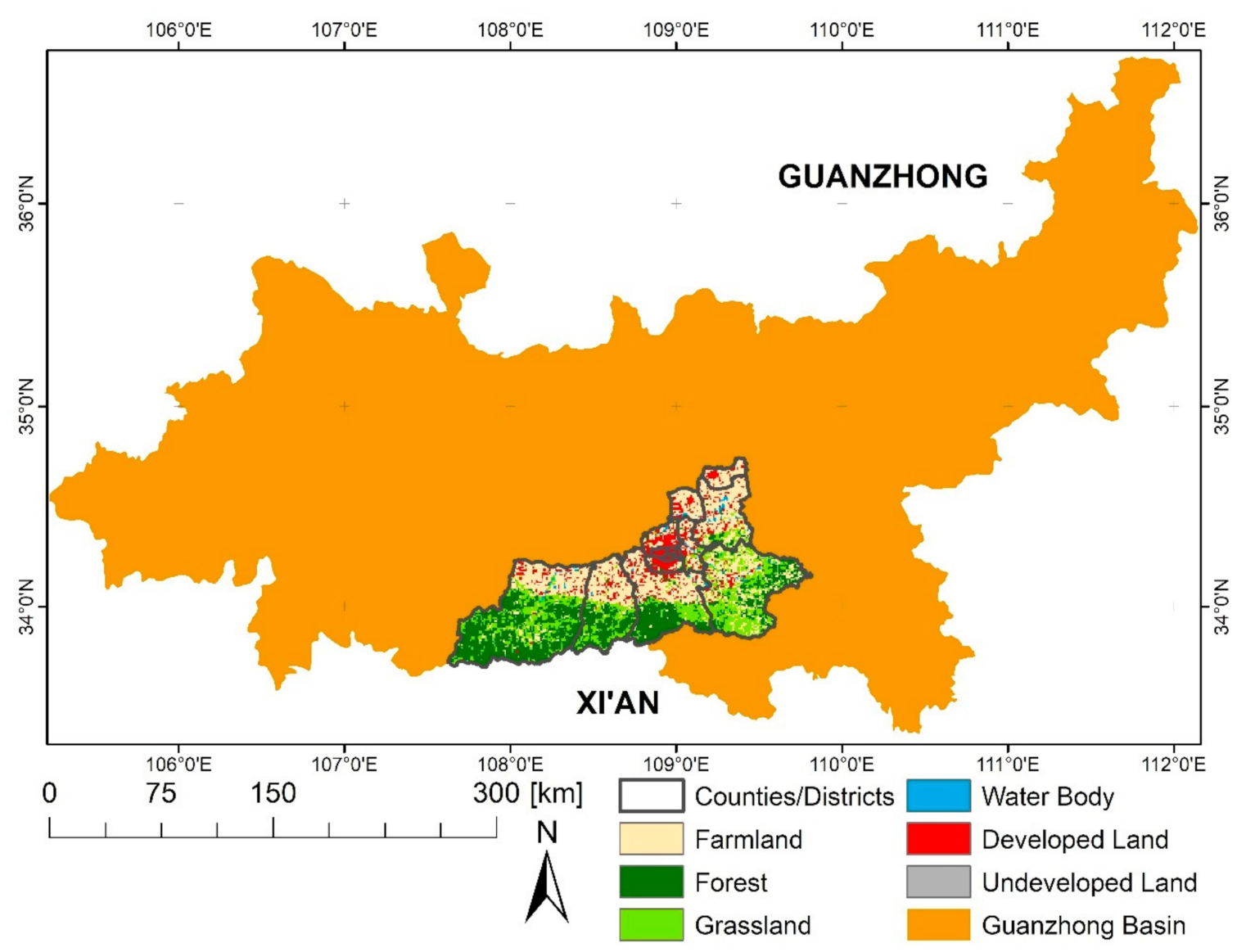
2.1. Study Area
2.2. Datasets and Processing
- Land Use/Cover Data: We used seven land use/cover datasets covering the years 1980, 1990, 1995, 2000, 2005, 2010, and 2015. The datasets were provided by the West Data Center [31] and include six categories (farmland, forest, grassland, waterbody, developed land, and undeveloped land) and 25 subclasses. We focused our analysis on the farmland category and the two subclasses urban built-up area and rural built-up area, with urban built-up area referring to residential land area in a city and rural built-up area referring to residential land area in the countryside. While many land use/cover datasets are available, we chose this dataset because of its excellent spatial and temporal resolution and consistency across time steps.
- Administrative Boundaries: We derived the boundaries for Xi’an with its 13 districts and counties from the digital version of the Chinese Administrative Zoning Map, obtained from the Data Application Environment of the Chinese Academy of Sciences [32].
- Road Network, Conservation Areas, and Development Zones: We derived spatial data on road networks and boundaries of protected areas and development zones from the Xi’an City Planning and Design Institute [33].
- Population Numbers and GDP: We extracted spatial data on population numbers (1995–2015) and GDP (1980–2015) on the county/district level from the Xi’an Statistical Yearbooks [34] spanning the period from 1980 to 2015.
2.3. Urbanization Intensity
2.4. Logistic Regression Analysis
3. Results
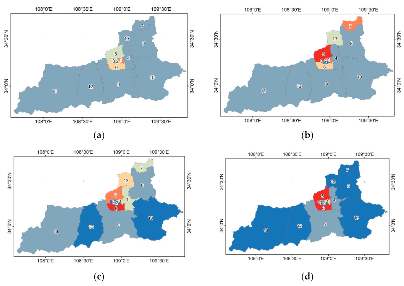
3.1. Land-Use Change
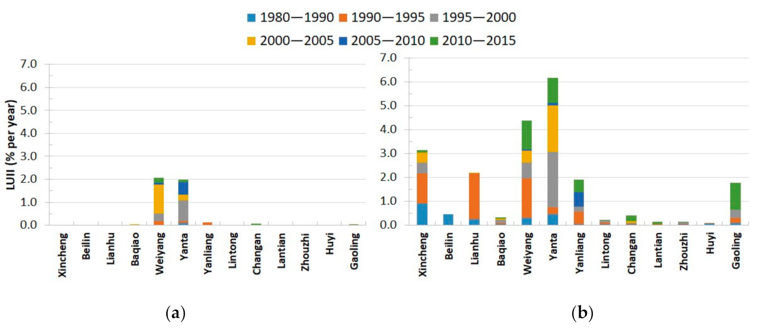
3.2. Urbanization Intensity
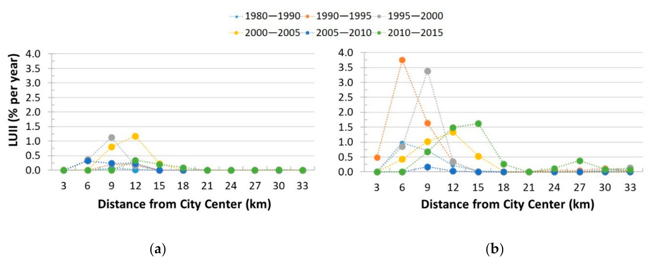
3.3. Urbanization along the Urban–Rural Gradient
3.4. Drivers of Urbanization
4. Discussion
4.1. Impacts of Land-Use Change
- (1)
- Urbanization is often caused by population growth leading to an increase in food requirements. This means that farmland is lost due to urban expansion, while at the same time the demand for food and fiber increases [51].
- (2)
- Urban expansion leads to a displacement of farmland to new, often less productive areas (i.e., indirect land-use change). This indirect land-use change effect can result in additional area requirements to meet the same production values, and can lead to additional loss of biodiversity, either through loss of natural vegetation or an intensification of farming practices [16,17,52].
4.2. Spatial and Temporal Patterns of Urbanization in Northwest China
4.3. Study Limitations and Next Steps
5. Conclusions
Author Contributions
Funding
Acknowledgments
Conflicts of Interest
References
- Seto, K.C.; Fragkias, M.; Güneralp, B.; Reilly, M.K. A meta-analysis of global urban land expansion. PLoS ONE 2011, 6, e23777. [Google Scholar] [CrossRef] [PubMed]
- Seto, K.C.; Guneralp, B.; Hutyra, L.R. Global forecasts of urban expansion to 2030 and direct impacts on biodiversity and carbon pools. Proc. Natl. Acad. Sci. USA 2012, 109, 16083–16088. [Google Scholar] [CrossRef] [PubMed] [Green Version]
- World Bank. World Development Indicators 2016; World Bank: Washington, DC, USA, 2016. [Google Scholar]
- Li, H.; Wei, Y.H.D.; Huang, Z. Urban land expansion and spatial dynamics in Globalizing Shanghai. Sustainability 2014, 6, 8856–8875. [Google Scholar] [CrossRef] [Green Version]
- Liu, J.; Zhan, J.; Deng, X. Spatio-temporal Patterns and Driving Forces of Urban Land Expansion in China during the Economic Reform Era. AMBIO J. Hum. Environ. 2005, 34, 450–455. [Google Scholar] [CrossRef]
- Song, W.; Deng, X. Effects of urbanization-induced cultivated land loss on ecosystem services in the north China plain. Energies 2015, 8, 5678–5693. [Google Scholar] [CrossRef]
- Tian, G.; Jiang, J.; Yang, Z.; Zhang, Y. The urban growth, size distribution and spatio-temporal dynamic pattern of the Yangtze River Delta megalopolitan region, China. Ecol. Model. 2011, 222, 865–878. [Google Scholar] [CrossRef]
- Wu, W.; Zhao, S.; Zhu, C.; Jiang, J. A comparative study of urban expansion in Beijing, Tianjin and Shijiazhuang over the past three decades. Landsc. Urban Plan. 2015, 134, 93–106. [Google Scholar] [CrossRef]
- Liu, Y.; Yang, Y.; Li, Y.; Li, J. Conversion from rural settlements and arable land under rapid urbanization in Beijing during 1985–2010. J. Rural Stud. 2017, 51, 141–150. [Google Scholar] [CrossRef]
- Zhao, S.; Zhou, D.; Zhu, C.; Qu, W.; Zhao, J.; Sun, Y.; Huang, D.; Wu, W.; Liu, S. Rates and patterns of urban expansion in China’s 32 major cities over the past three decades. Landsc. Ecol. 2015, 30, 1541–1559. [Google Scholar] [CrossRef]
- Chen, J.; Gao, J.; Yuan, F.; Wei, Y.D. Spatial determinants of urban land expansion in globalizing Nanjing, China. Sustainability 2016, 8, 868. [Google Scholar] [CrossRef] [Green Version]
- Liu, J.; Liu, Y.; Yan, M. Spatial and temporal change in urban-rural land use transformation at village scale—A case study of Xuanhua district, North China. J. Rural Stud. 2016, 47, 425–434. [Google Scholar] [CrossRef]
- Chen, L.; Sun, R.; Liu, H. Eco-environmental effects of urban landscape pattern changes: Progresses, problems, and perspectives. Acta Ecol. Sin. 2013, 33, 1042–1050. [Google Scholar] [CrossRef] [Green Version]
- Zhou, D.; Shi, P.; Wu, X.; Ma, J.; Yu, J. Effects of urbanization expansion on landscape pattern and region ecological risk in Chinese coastal city: A case study of Yantai city. Sci. World J. 2014, 2014, 1–9. [Google Scholar] [CrossRef] [Green Version]
- Foley, J.A.; Defries, R.; Asner, G.P.; Barford, C.; Bonan, G.; Carpenter, S.R.; Chapin, F.S.; Coe, M.T.; Daily, G.C.; Gibbs, H.K.; et al. Global consequences of land use. Science 2005, 309, 570–574. [Google Scholar] [CrossRef] [Green Version]
- Koch, J.; Wimmer, F.; Schaldach, R. Analyzing the relationship between urbanization, food supply and demand, and irrigation requirements in Jordan. Sci. Total Environ. 2018, 636, 1500–1509. [Google Scholar] [CrossRef] [PubMed]
- Yang, B.; Ke, X.; van Vliet, J.; Yu, Q.; Zhou, T.; Verburg, P.H. Impact of cropland displacement on the potential crop production in China: A multi-scale analysis. Reg. Environ. Change 2020, 20, 97. [Google Scholar] [CrossRef]
- Zhou, L.; Dickinson, R.E.; Tian, Y.; Fang, J.; Li, Q.; Kaufmann, R.K.; Tucker, C.J.; Myneni, R.B. Evidence for a significant urbanization effect on climate in China. Proc. Natl. Acad. Sci. USA 2004, 101, 9540–9544. [Google Scholar] [CrossRef] [Green Version]
- Tan, M.; Li, X.; Xie, H.; Lu, C. Urban land expansion and arable land loss in China—A case study of Beijing-Tianjin-Hebei region. Land Use Policy 2005, 22, 187–196. [Google Scholar] [CrossRef]
- Wang, J.; Chen, Y.; Shao, X.; Zhang, Y.; Cao, Y. Land-use changes and policy dimension driving forces in China: Present, trend and future. Land Use Policy 2012, 29, 737–749. [Google Scholar] [CrossRef]
- Long, H.; Zou, J.; Liu, Y. Differentiation of rural development driven by industrialization and urbanization in eastern coastal China. Habitat Int. 2009, 33, 454–462. [Google Scholar] [CrossRef]
- Liu, F.; Zhang, Z.; Zhao, X.; Wang, X.; Zuo, L.; Wen, Q.; Yi, L.; Xu, J.; Hu, S.; Liu, B. Chinese cropland losses due to urban expansion in the past four decades. Sci. Total Environ. 2019, 650, 847–857. [Google Scholar] [CrossRef] [PubMed]
- Wang, X.F.; Fu, B.J.; Su, C.H.; Wang, R.R.; Zhao, Y.H.; Li, T.S. Spatio-temporal characteristics and driving forces of built-up land in Xi’an, China. Acta Ecol. Sin. 2015, 35, 7139–7149. (In Chinese) [Google Scholar] [CrossRef]
- Li, W.; Shen, J.; Liu, D. Study on development zones in Xi’an. Econ. Anal. 2016, 7, 95–97. (In Chinese) [Google Scholar]
- Wang, H. The NSDZs-led Urban Sprawl in Xi’an: A Non-typical Suburbanization. Reg. Dev. 2007, 10, 93–103. (In Chinese) [Google Scholar]
- Fang, C.; Zhao, S. A comparative study of spatiotemporal patterns of urban expansion in six major cities of the Yangtze River Delta from 1980 to 2015. Ecosyst. Health Sustain. 2018, 4, 95–114. [Google Scholar] [CrossRef] [Green Version]
- Lu, S.; Guan, X.; He, C.; Zhang, J. Spatio-Temporal Patterns and Policy Implications of Urban Land Expansion in Metropolitan Areas: A Case Study of Wuhan Urban Agglomeration, Central China. Sustainability 2014, 6, 4723–4748. [Google Scholar] [CrossRef] [Green Version]
- Liu, Y.; Yue, W.; Fan, P. Spatial determinants of urban land conversion in large Chinese cities: A case of Hangzhou. Environ. Plan. B Plan. Des. 2011, 38, 706–725. [Google Scholar] [CrossRef]
- Development Planning of Guanzhong Plain Urban Agglomeration. Available online: https://www.ndrc.gov.cn/xxgk/zcfb/ghwb/201802/t20180207_962246.html (accessed on 14 July 2020).
- Population Development Plan of Shaanxi Province (2016–2030). Available online: http://www.shaanxi.gov.cn/gk/zfwj/99134.htm (accessed on 14 July 2020).
- West Data Center. Land Use/Land Cover Data. Available online: http://westdc.westgis.ac.cn/ (accessed on 18 April 2018).
- Data Application Environment of the Chinese Academy of Sciences. Chinese Administrative Zoning Map. Available online: http://rsr.csdb.cn (accessed on 28 April 2018).
- Xi’an City Planning and Design Institute. Road Network, Conservation Areas, and Development Zones. Available online: http://www.xaguihua.com/ (accessed on 25 April 2018).
- Xi’an Statistical Yearbook. Population Numbers and GDP. Available online: http://tjj.xa.gov.cn (accessed on 30 April 2020).
- Alsharif, A.A.A.; Pradhan, B. Urban Sprawl Analysis of Tripoli Metropolitan City (Libya) Using Remote Sensing Data and Multivariate Logistic Regression Model. J. Indian Soc. Remote Sens. 2014, 42, 149–163. [Google Scholar] [CrossRef]
- Hu, Z.; Lo, C.P. Modeling urban growth in Atlanta using logistic regression. Comput. Environ. Urban Syst. 2007, 31, 667–688. [Google Scholar] [CrossRef]
- Cheng, J.; Masser, I. Urban growth pattern modeling: A case study of Wuhan city, PR China. Landsc. Urban Plan. 2003, 62, 199–217. [Google Scholar] [CrossRef]
- Dale, M.R.T.; Fortin, M.-J. Spatial autocorrelation and statistical tests in ecology. Ecoscience 2002, 9, 162–167. [Google Scholar] [CrossRef]
- Bates, D.; Maechler, M.; Bolker, B.; Walker, S. lme4: {Linear} mixed-effects models using {Eigen} and {S}4. R Package Version 2014, 1, 1–23. [Google Scholar]
- Meentemeyer, R.K.; Tang, W.; Dorning, M.A.; Vogler, J.B.; Cunniffe, N.J.; Shoemaker, D.A. FUTURES: Multilevel Simulations of Emerging Urban–Rural Landscape Structure Using a Stochastic Patch-Growing Algorithm. Ann. Assoc. Am. Geogr. 2013, 103, 785–807. [Google Scholar] [CrossRef] [Green Version]
- Dorning, M.A.; Koch, J.; Shoemaker, D.A.; Meentemeyer, R.K. Simulating urbanization scenarios reveals tradeoffs between conservation planning strategies. Landsc. Urban Plan. 2015, 136, 28–39. [Google Scholar] [CrossRef] [Green Version]
- Fotheringham, A.S.; Brunsdon, C. Local Forms of Spatial Analysis. Geogr. Anal. 1999, 31, 340–358. [Google Scholar] [CrossRef]
- Liu, X.; Huang, Y.; Xu, X.; Li, X.; Li, X.; Ciais, P.; Lin, P.; Gong, K.; Ziegler, A.D.; Chen, A.; et al. High-spatiotemporal-resolution mapping of global urban change from 1985 to 2015. Nat. Sustain. 2020, 3, 564–570. [Google Scholar] [CrossRef]
- Xu, X.; Peng, H.; Xu, Q.; Xiao, H.; Benoit, G. Land changes and conflicts coordination in coastal urbanization: A case study of the shandong peninsula in china. Coast. Manag. 2009, 37, 54–69. [Google Scholar] [CrossRef]
- Hualou, L.; Tingting, L. Analysis of the Coupling of Farmland and Rural Housing Land Transition in China. Acta Geogr. Sin. 2012, 67, 201–210. [Google Scholar]
- Yue, W.; Zhang, L.; Liu, Y. Measuring sprawl in large Chinese cities along the Yangtze River via combined single and multidimensional metrics. Habitat Int. 2016, 57, 43–52. [Google Scholar] [CrossRef]
- Bren d’Amour, C.; Reitsma, F.; Baiocchi, G.; Barthel, S.; Güneralp, B.; Erb, K.-H.; Haberl, H.; Creutzig, F.; Seto, K.C. Future urban land expansion and implications for global croplands. Proc. Natl. Acad. Sci. USA 2016, 114, 8939–8944. [Google Scholar] [CrossRef] [Green Version]
- Tan, R.; Beckmann, V.; van den Berg, L.; Qu, F. Governing farmland conversion: Comparing China with the Netherlands and Germany. Land Use Policy 2009, 26, 961–974. [Google Scholar] [CrossRef]
- Chen, M.; Liu, W.; Lu, D. Challenges and the way forward in China’s new-type urbanization. Land Use Policy 2016, 55, 334–339. [Google Scholar] [CrossRef]
- Mattison, E.H.A.; Norris, K. Bridging the gaps between agricultural policy, land-use and biodiversity. Trends Ecol. Evol. 2005, 20, 610–616. [Google Scholar] [CrossRef]
- Yu, A.T.W.; Wu, Y.; Zheng, B.; Zhang, X.; Shen, L. Identifying risk factors of urban-rural conflict in urbanization: A case of China. Habitat Int. 2014, 44, 177–185. [Google Scholar] [CrossRef]
- Lapola, D.M.; Schaldach, R.; Alcamo, J.; Bondeau, A.; Koch, J.; Koelking, C.; Priess, J.A. Indirect land-use changes can overcome carbon savings from biofuels in Brazil. Proc. Natl. Acad. Sci. USA 2010, 107, 3388–3393. [Google Scholar] [CrossRef] [Green Version]
- Long, H.; Li, Y.; Liu, Y.; Woods, M.; Zou, J. Accelerated restructuring in rural China fueled by ‘increasing vs. decreasing balance’ land-use policy for dealing with hollowed villages. Land Use Policy 2012, 29, 11–22. [Google Scholar] [CrossRef]
- Liu, T.; Liu, H.; Qi, Y. Construction land expansion and cultivated land protection in urbanizing China: Insights from national land surveys, 1996-2006. Habitat Int. 2015, 46, 13–22. [Google Scholar] [CrossRef]
- Wei, Y.D. Zone Fever, Project Fever: Development Policy, Economic Transition, and Urban Expansion in China. Geogr. Rev. 2015, 105, 156–177. [Google Scholar] [CrossRef]
- Wei, Y.H.D. Restructuring for growth in urban China: Transitional institutions, urban development, and spatial transformation. Habitat Int. 2012, 36, 396–405. [Google Scholar] [CrossRef]
- United Nations General Assembly Resolution A/RES/70/1. Transforming Our World: The 2030 Agenda for Sustainable Development; Division for Sustainable Development Goals: New York, NY, USA, 2015. [Google Scholar]
- Liu, Y. Introduction to land use and rural sustainability in China. Land Use Policy 2018, 74, 1–4. [Google Scholar] [CrossRef]
- Koch, J.; Dorning, M.A.; Van Berkel, D.B.; Beck, S.M.; Sanchez, G.M.; Shashidharan, A.; Smart, L.S.; Zhang, Q.; Smith, J.W.; Meentemeyer, R.K. Modeling landowner interactions and development patterns at the urban fringe. Landsc. Urban Plan. 2019, 182, 101–113. [Google Scholar] [CrossRef]


| Category | Parameter | Description |
|---|---|---|
| Environment | Topography | Terrain slope 1 |
| Environment | Hydrological features | Distance to water bodies 1 |
| Environment | Land use/cover | Land classification system (2nd level) 1 |
| Infrastructure | Roads | Distance to roadways 2 |
| Infrastructure | Highways | Distance to highways (incl. national roads, provincial roads, and urban highways) 2 |
| Infrastructure | Road density | Road density within varying ranges (3000 m) 2 |
| Infrastructure | Travel time | Travel time to cities in the Guanzhong Plain City Agglomeration 3 |
| Infrastructure | Subway | Distance to subways 2 |
| Policy | Protected areas | Distance to historical relics sites 2 |
| Policy | Development zone | Distance to development zones 2 |
| Socioeconomic | City center/subcenters | Distance to city center and subcenters 2 |
| Socioeconomic | Administrative boundaries | County boundaries 3 |
| Planning | Planning area | Planning area set to 1, all other areas set to 0 2 |
| Year | Urban Built-Up (km2) | Rural Built-Up (km2) | Farmland (km2) |
|---|---|---|---|
| 1980 | 174.1 | 542.0 | 3967.8 |
| 1990 | 190.6 | 497.6 | 4098.0 |
| 1995 | 204.1 | 475.2 | 3923.9 |
| 2000 | 238.6 | 586.6 | 3885.0 |
| 2005 | 303.0 | 604.1 | 3761.3 |
| 2010 | 319.7 | 599.6 | 3739.4 |
| 2015 | 410.8 | 627.9 | 3585.8 |
| Period | Urban Built-Up | Loss of Rural Built-Up | Loss of Farmland | |||
|---|---|---|---|---|---|---|
| Change (%) | Area (km2) | Area (km2) | Contribution (%) | Area (km2) | Contribution (%) | |
| 1980–1990 | 9.5 | 16.5 | 1.4 | 8.3 | 12.8 | 77.8 |
| 1990–1995 | 7.1 | 13.5 | 6.8 | 50.6 | 5.4 | 39.9 |
| 1995–2000 | 16.9 | 34.5 | 11.2 | 32.4 | 17.4 | 50.4 |
| 2000–2005 | 27.0 | 64.4 | 20.2 | 31.3 | 29.2 | 45.3 |
| 2005–2010 | 5.5 | 16.8 | 5.4 | 32.44 | 10.1 | 60.5 |
| 2010–2015 | 28.5 | 91.1 | 8.2 | 9.0 | 78.4 | 86.1 |
| Estimate | Std. Error | Pr (>|z|) | ||
|---|---|---|---|---|
| (Intercept) | 2.505 | 0.677 | 0.000214 | *** |
| Terrain slope | −0.048 | 0.016 | 0.003243 | ** |
| Road density | 0.016 | 0.007 | 0.013552 | * |
| Planning area | 2.053 | 0.192 | <2 × 10⁻¹⁶ | *** |
| Distance to (sub-)center | −0.314 | 0.025 | <2 × 10⁻¹⁶ | *** |
| Highways | −0.072 | 0.030 | 0.017157 | * |
| Travel time | −0.027 | 0.016 | 0.091325 | |
| District/County | Intercept 1 |
|---|---|
| Xincheng | 4.31 |
| Beilin | 4.65 |
| Lianhu | 4.95 |
| Baqiao | 0.68 |
| Weiyang | 4.47 |
| Yanta | 3.65 |
| Yanliang | 1.10 |
| Lintong | 0.02 |
| Chang’an | 3.83 |
| Lantian | 1.61 |
| Zhouzhi | 1.28 |
| Huyi | −0.57 |
| Gaoling | 1.53 |
Publisher’s Note: MDPI stays neutral with regard to jurisdictional claims in published maps and institutional affiliations. |
© 2020 by the authors. Licensee MDPI, Basel, Switzerland. This article is an open access article distributed under the terms and conditions of the Creative Commons Attribution (CC BY) license (http://creativecommons.org/licenses/by/4.0/).
Share and Cite
Lei, H.; Koch, J.; Shi, H. An Analysis of Spatio-Temporal Urbanization Patterns in Northwest China. Land 2020, 9, 411. https://doi.org/10.3390/land9110411
Lei H, Koch J, Shi H. An Analysis of Spatio-Temporal Urbanization Patterns in Northwest China. Land. 2020; 9(11):411. https://doi.org/10.3390/land9110411
Chicago/Turabian StyleLei, Haifen, Jennifer Koch, and Hui Shi. 2020. "An Analysis of Spatio-Temporal Urbanization Patterns in Northwest China" Land 9, no. 11: 411. https://doi.org/10.3390/land9110411
APA StyleLei, H., Koch, J., & Shi, H. (2020). An Analysis of Spatio-Temporal Urbanization Patterns in Northwest China. Land, 9(11), 411. https://doi.org/10.3390/land9110411