Integrating Ecosystem Services into Land-Use Modeling to Assess the Effects of Future Land-Use Strategies in Northern Ghana


Abstract
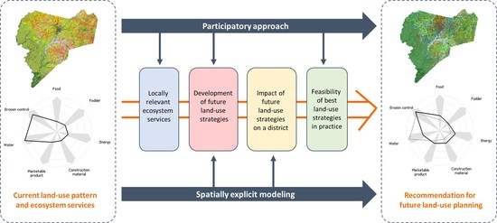
1. Introduction
- How can local perspectives be reflected in identifying the most feasible land-use strategies?
- What kind of synergies and trade-offs appear between ES depending on land-use strategies?
- How do local perspectives and characteristics influence the results on district level?
- What are the advantages and challenges of the applied stakeholder-based ES modeling approach?
- How the application of the ES concept in land-use planning in the West African context can be improved?
2. Material and Methods
2.1. Case Study Area
2.2. Database and Selection Processes
2.3. Development of Future Land-Use Strategies
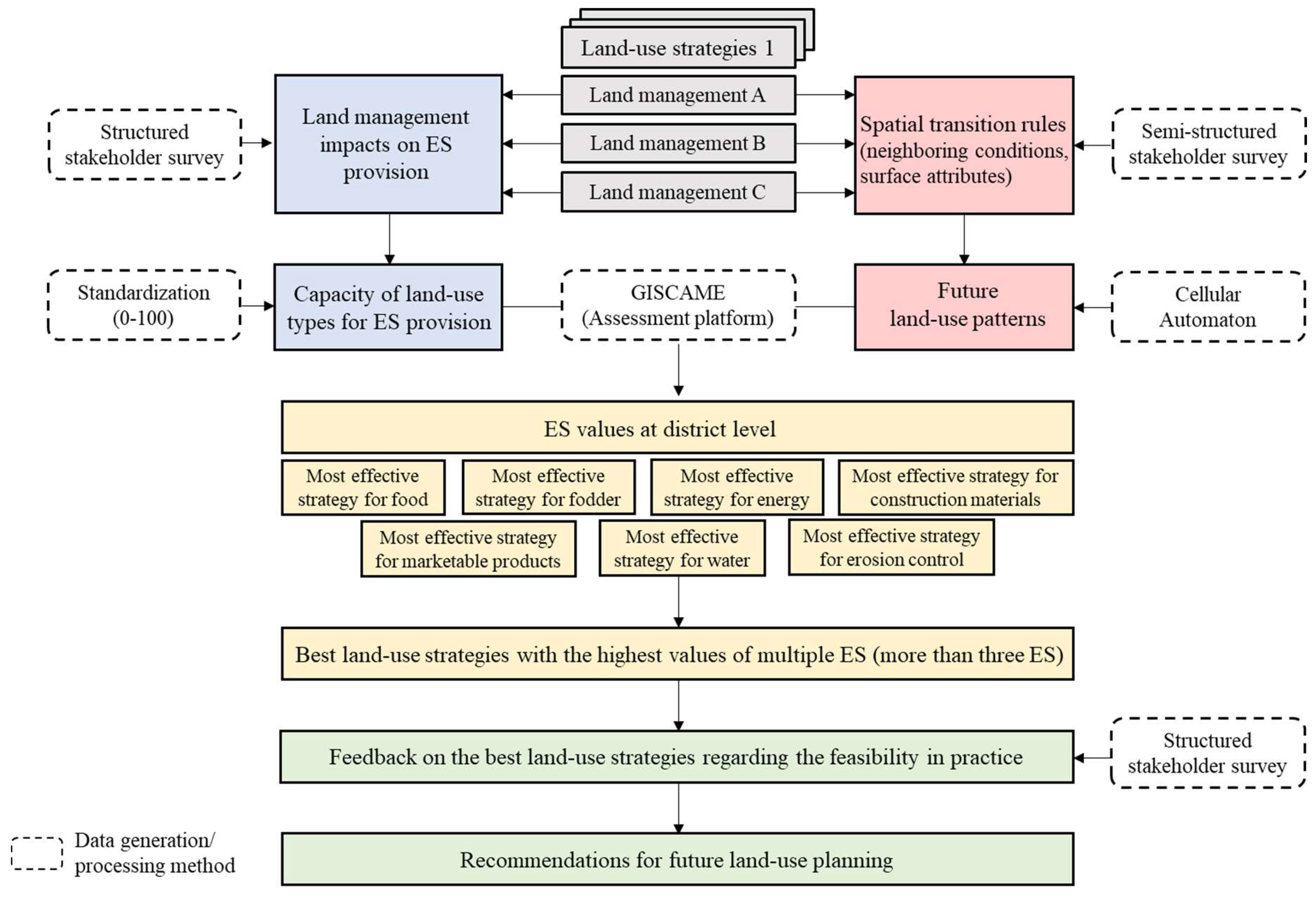
2.4. Assessment Process for Potential Impacts of Land-Use Strategies on Ecosystem Services
2.4.1. Capacity of Land-Use Types to Provide Ecosystem Services
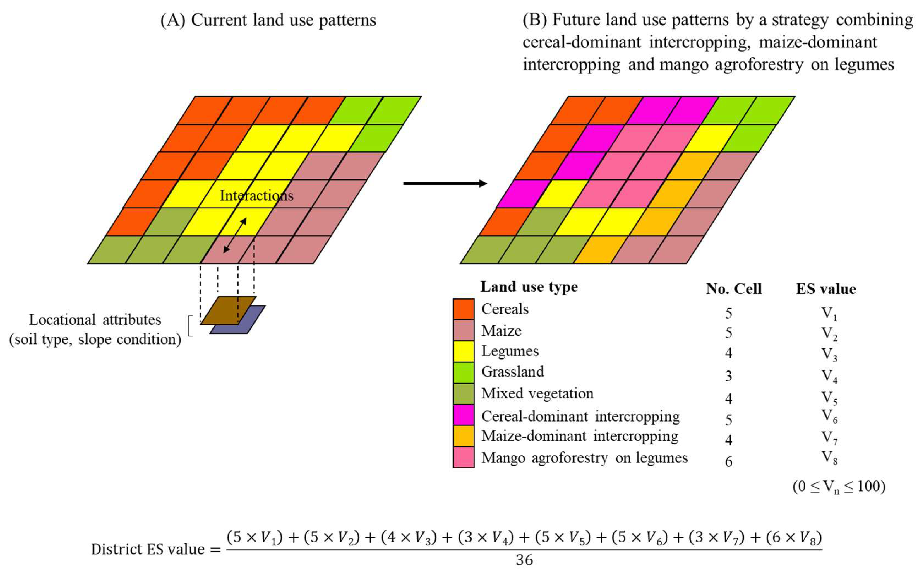
2.4.2. Future Land-Use Patterns by Land-Use Strategies
2.4.3. Identification of Ecosystem Services Values and Feasible Land-Use Strategies at District Level
3. Results
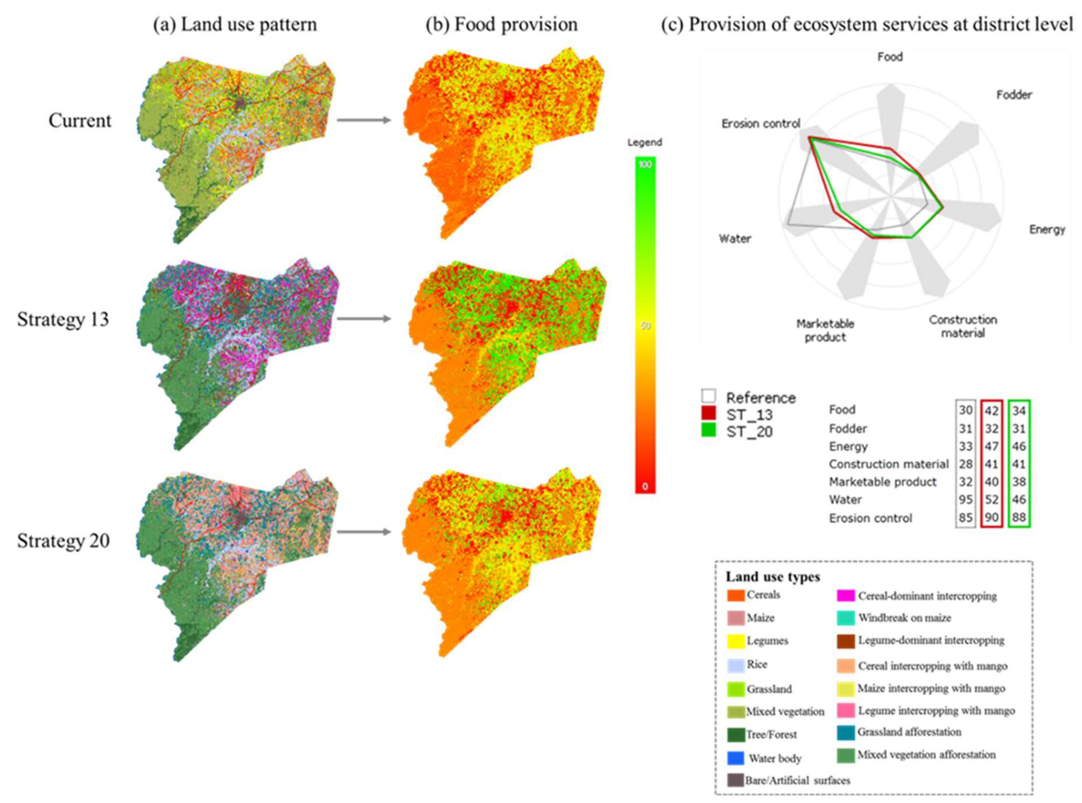
3.1. Ecosystem Services Values of Future Land-Use Strategies at District Level
3.2. Locally Recommendable Land-Use Strategies
4. Discussion and Outlook
4.1. Discussion of the Findings
4.2. Methodological Discussion
4.3. Future Directions of Using the Ecosystem Service Concept for Land-Use Planning in West Africa
5. Conclusions
Supplementary Materials
Author Contributions
Funding
Acknowledgments
Conflicts of Interest
References
- Bennett, E.M.; Cramer, W.; Begossi, A.; Cundill, G.; Díaz, S.; Egoh, B.N.; Geijzendorffer, I.R.; Krug, C.B.; Lavorel, S.; Lazos, E.; et al. Linking biodiversity, ecosystem services, and human well-being: Three challenges for designing research for sustainability. Curr. Opin. Environ. Sustain. 2015, 14, 76–85. [Google Scholar] [CrossRef]
- McPhearson, T.; Andersson, E.; Elmqvist, T.; Frantzeskaki, N. Resilience of and through urban ecosystem services. Ecosyst. Serv. 2015, 12, 152–156. [Google Scholar] [CrossRef]
- Reyers, B.; Biggs, R.; Cumming, G.S.; Elmqvist, T.; Hejnowicz, A.P.; Polasky, S. Getting the measure of ecosystem services: A social–ecological approach. Front. Ecol. Environ. 2013, 11, 268–273. [Google Scholar] [CrossRef]
- Sumarga, E.; Hein, L.; Edens, B.; Suwarno, A. Mapping monetary values of ecosystem services in support of developing ecosystem accounts. Ecosyst. Serv. 2015, 12, 71–83. [Google Scholar] [CrossRef]
- Bai, Y.; Wong, C.P.; Jiang, B.; Hughes, A.C.; Wang, M.; Wang, Q. Developing China’s Ecological Redline Policy using ecosystem services assessments for land-use planning. Nat. Commun. 2018, 9, 1–13. [Google Scholar] [CrossRef]
- Metternicht, G. Land-Use Planning. Global Land Outlook Working Paper, 2017. United Nations Convention to Combat Desertification (UNCCD). Available online: https://knowledge.unccd.int/sites/default/files/2018–06/6.%20Land%2BUse%2BPlanning%2B__G_Metternicht.pdf (accessed on 18 September 2018).
- De Noronha Vaz, E.; Nijkamp, P.; Painho, M.; Caetano, M. A multi-scenario forecast of urban change: A study on urban growth in the Algarve. Landsc. Urban Plan. 2012, 104, 201–211. [Google Scholar] [CrossRef]
- Burkhard, B.; Kroll, F.; Nedkov, S.; Müller, F. Mapping ecosystem service supply, demand and budgets. Ecol. Indic. 2012, 21, 17–29. [Google Scholar] [CrossRef]
- Gómez-Baggethun, E.; Barton, D. Classifying and valuing ecosystem services for urban planning. Ecol. Econ. 2013, 86, 235–245. [Google Scholar] [CrossRef]
- Huq, N.; Bruns, A.; Ribbe, L. Interactions between freshwater ecosystem services and land cover changes in southern Bangladesh: A perspective from short-term (seasonal) and long-term (1973–2014) scale. Sci. Total Environ. 2019, 650, 132–143. [Google Scholar] [CrossRef]
- Salata, S.; Ronchi, S.; Arcidiacono, A. Mapping air filtering in urban areas. A land use regression model for ecosystem services assessment in planning. Ecosyst. Serv. 2017, 28, 341–350. [Google Scholar] [CrossRef]
- Karner, K.; Cord, A.F.; Hagemann, N.; Hernandez-Mora, N.; Holzkämper, A.; Jeangros, B.; Lienhoop, N.; Nitsch, H.; Rivas, D.; Schmid, E.; et al. Developing stakeholder-driven scenarios on land sharing and land sparing–Insights from five European case studies. J. Environ. Manag. 2019, 241, 488–500. [Google Scholar] [CrossRef] [PubMed]
- Saito, O.; Kamiyama, C.; Hashimoto, S.; Matsui, T.; Shoyama, K.; Kabaya, K.; Uetake, T.; Taki, H.; Ishikawa, Y.; Matsushita, K.; et al. Co-design of national-scale future scenarios in Japan to predict and assess natural capital and ecosystem services. Sustain. Sci. 2019, 14, 5–21. [Google Scholar] [CrossRef]
- Barnett, A.; Fargione, J.; Smith, M.P. Mapping trade-offs in ecosystem services from reforestation in the Mississippi alluvial valley. BioScience 2016, 66, 223–237. [Google Scholar] [CrossRef]
- Clerici, N.; Cote-Navarro, F.; Escobedo, F.J.; Rubiano, K.; Villegas, J.C. Spatio-temporal and cumulative effects of land use-land cover and climate change on two ecosystem services in the Colombian Andes. Sci. Total Environ. 2019, 685, 1181–1192. [Google Scholar] [CrossRef] [PubMed]
- Peng, J.; Liu, Y.; Tian, L. Integrating ecosystem services trade-offs with paddy land-to-dry land decisions: A scenario approach in Erhai Lake Basin, southwest China. Sci. Total Environ. 2018, 625, 849–860. [Google Scholar] [CrossRef]
- Leh, M.D.K.; Matlock, M.D.; Cummings, E.C.; Nalley, L.L. Quantifying and mapping multiple ecosystem services change in West Africa. Agric. Ecosyst. Environ. 2013, 165, 6–18. [Google Scholar] [CrossRef]
- Inkoom, J.N.; Frank, S.; Fürst, C. Challenges and opportunities of ecosystem service integration into land-use planning in West Africa—An implementation framework. Int. J. Biodivers. Sci. Ecosyst. Serv. Manag. 2017, 13, 67–81. [Google Scholar] [CrossRef]
- Sultan, B.; Gaetani, M. Agriculture in West Africa in the twenty-first century: Climate change and impacts scenarios, and potential for adaptation. Front. Plant Sci. 2016, 7, 1262. [Google Scholar] [CrossRef]
- Emmanuel, D.; Owusu-Sekyere, E.; Owusu, V.; Jordaan, H. Impact of agricultural extension service on adoption of chemical fertilizer: Implications for rice productivity and development in Ghana. NJAS-Wageningen J. Life Sci. 2016, 79, 41–49. [Google Scholar] [CrossRef]
- IFPRI. West African Agriculture and Climate Change: A Comprehensive Analysis. 2013. Available online: https://www.ifpri.org/publication/west-african-agriculture-and-climate-change-comprehensive-analysis (accessed on 8 August 2020).
- Kleemann, J.; Celio, E.; Nyarko, B.K.; Jimenez-Martinez, M.; Fürst, C. Assessing the risk of seasonal food insecurity with an expert-based Bayesian Belief Network approach in northern Ghana, West Africa. Ecol. Complex. 2017, 32, 53–73. [Google Scholar] [CrossRef]
- Kleemann, J.; Celio, E.; Fürst, C. Validation approaches of an expert-based Bayesian Belief Network in Northern Ghana, West Africa. Ecol. Model. 2017, 365, 10–29. [Google Scholar] [CrossRef]
- Douxchamps, S.; Van Wijk, M.T.; Silvestri, S.; Moussa, A.S.; Quiros, C.; Ndour, N.Y.B.; Buah, S.; Somé, L.; Herrero, M.; Kristjanson, P.; et al. Linking agricultural adaptation strategies, food security and vulnerability: Evidence from West Africa. Reg. Environ. Chang. 2016, 16, 1305–1317. [Google Scholar] [CrossRef]
- Ayambire, R.A.; Amponsah, O.; Peprah, C.; Takyi, S.A. A review of practices for sustaining urban and peri-urban agriculture: Implications for land-use planning in rapidly urbanising Ghanaian cities. Land Use Policy 2019, 84, 260–277. [Google Scholar] [CrossRef]
- Adekola, O.; Mitchell, G.; Grainger, A. Inequality and ecosystem services: The value and social distribution of Niger Delta wetland services. Ecosyst. Serv. 2015, 12, 42–54. [Google Scholar] [CrossRef]
- Koo, H.; Kleemann, J.; Fürst, C. Impact assessment of land use changes using local knowledge for the provision of ecosystem services in northern Ghana, West Africa. Ecol. Indic. 2019, 103, 156–172. [Google Scholar] [CrossRef]
- Kumar, V. Multifunctional agroforestry systems in tropics region. Nat. Environ. Pollut. Technol. 2016, 15, 365. [Google Scholar]
- Santos, P.Z.F.; Crouzeilles, R.; Sansevero, J.B.B. Can agroforestry systems enhance biodiversity and ecosystem service provision in agricultural landscapes? A meta-analysis for the Brazilian Atlantic Forest. For. Ecol. Manag. 2019, 433, 140–145. [Google Scholar] [CrossRef]
- Geneletti, D.; Scolozzi, R.; Esmail, B.A. Assessing ecosystem services and biodiversity tradeoffs across agricultural landscapes in a mountain region. Int. J. Biodivers. Sci. Ecosyst. Serv. Manag. 2018, 14, 188–208. [Google Scholar] [CrossRef]
- Fischer, J.; Abson, D.J.; Bergsten, A.; Collier, N.F.; Dorresteijn, I.; Hanspach, J.; Hylander, K.; Schultner, J.; Senbeta, F. Reframing the food–biodiversity challenge. Trends Ecol. Evol. 2017, 32, 335–345. [Google Scholar] [CrossRef]
- Boumans, R.; Roman, J.; Altman, I.; Kaufman, L. The multiscale integrated model of ecosystem services (MIMES): Simulating the interactions of coupled human and natural systems. Ecosyst. Serv. 2015, 12, 30–41. [Google Scholar] [CrossRef]
- Sutherland, W.J.; Gardner, T.A.; Jamila Haider, L.; Dicks, L.V. How can local and traditional knowledge be effectively incorporated into international assessments? Oryx 2014, 48, 1–2. [Google Scholar] [CrossRef]
- Haatanen, A.; den Herder, M.; Leskinen, P.; Lindner, M.; Kurttila, M.; Salminen, O. Stakeholder engagement in scenario development process–bioenergy production and biodiversity conservation in eastern Finland. J. Environ. Manag. 2014, 135, 45–53. [Google Scholar] [CrossRef]
- Spyra, M.; Kleemann, J.; Cetin, N.I.; Navarrete, C.J.V.; Albert, C.; Palacios-Agundez, I.; Ametzaga-Arregi, I.; La Rosa, D.; Rozas-Vásquez, D.; Esmail, B.A.; et al. The ecosystem services concept: A new Esperanto to facilitate participatory planning processes? Landsc. Ecol. 2019, 34, 1715–1735. [Google Scholar] [CrossRef]
- Cunningham, S. Getting the Best from Our Land: A Land-Use Strategy for Scotland 2016–2021. 2012. Available online: https://www.gov.scot/binaries/content/documents/govscot/publications/strategy-plan/2011/03/getting-best-land-land-use-strategy-scotland/documents/0115155-pdf/0115155-pdf/govscot%3Adocument/0115155.pdf (accessed on 14 March 2018).
- Hewitt, R.; Van Delden, H.; Escobar, F. Participatory land use modelling, pathways to an integrated approach. Environ. Model. Softw. 2014, 52, 149–165. [Google Scholar] [CrossRef]
- Jacobs, S.; Dendoncker, N.; Martín-López, B.; Barton, D.N.; Gomez-Baggethun, E.; Boeraeve, F.; McGrath, F.L.; Vierikko, K.; Geneletti, D.; Sevecke, K.J.; et al. A new valuation school: Integrating diverse values of nature in resource and land use decisions. Ecosyst. Serv. 2016, 22, 213–220. [Google Scholar] [CrossRef]
- Von Haaren, C.; Albert, C.; Barkmann, J.; de Groot, R.S.; Spangenberg, J.H.; Schröter-Schlaack, C.; Hansjürgens, B. From explanation to application: Introducing a practice-oriented ecosystem services evaluation (PRESET) model adapted to the context of landscape planning and management. Landsc. Ecol. 2014, 29, 1335–1346. [Google Scholar] [CrossRef]
- Klosterman, R.E. Lessons learned about planning: Forecasting, participation, and technology. J. Am. Plan. Assoc. 2013, 79, 161–169. [Google Scholar] [CrossRef]
- Liang, X.; Liu, X.; Li, D.; Zhao, H.; Chen, G. Urban growth simulation by incorporating planning policies into a CA-based future land-use simulation model. Int. J. Geogr. Inf. Sci. 2018, 32, 2294–2316. [Google Scholar] [CrossRef]
- Lindeskog, M.; Arneth, A.; Bondeau, A.; Waha, K.; Seaquist, J.; Olin, S.; Smith, B. Implications of accounting for land use in simulations of ecosystem services and carbon cycling in Africa. Earth Syst. Dynam. Discuss. 2013, 4, 235–278. [Google Scholar] [CrossRef]
- Tobias, S.; Buser, T.; Buchecker, M. Does real-time visualization support local stakeholders in developing landscape visions? Environ. Plan. B 2016, 43, 184–197. [Google Scholar] [CrossRef]
- Mukul, S.A.; Sohel, M.S.I.; Herbohn, J.; Inostroza, L.; König, H. Integrating ecosystem services supply potential from future land-use scenarios in protected area management: A Bangladesh case study. Ecosyst. Serv. 2017, 26, 355–364. [Google Scholar] [CrossRef]
- Ahmed, K.F.; Wang, G.; You, L.; Yu, M. Potential impact of climate and socioeconomic changes on future agricultural land use in West Africa. Earth Syst. Dynam. 2016, 7, 151–165. [Google Scholar] [CrossRef]
- Salack, S.; Sarr, B.; Sangare, S.K.; Ly, M.; Sanda, I.S.; Kunstmann, H. Crop-climate ensemble scenarios to improve risk assessment and resilience in the semi-arid regions of West Africa. Clim. Res. 2015, 65, 107–121. [Google Scholar] [CrossRef]
- Koo, H.; Kleemann, J.; Fürst, C. Land use scenario modeling based on local knowledge for the provision of ecosystem services in northern Ghana. Land 2018, 7, 59. [Google Scholar] [CrossRef]
- Ghana Statistical Service. District Analytical Report: Bolgatanga Municipality and Bongo. 2010. Available online: http://www.statsghana.gov.gh/docfiles/2010_District_Report/Upper%20East/Bolga.pdf (accessed on 2 December 2016).
- Issahaku, A.R.; Campion, B.B.; Edziyie, R. Rainfall and temperature changes and variability in the Upper East Region of Ghana. Earth Space Sci. 2016, 3, 284–294. [Google Scholar] [CrossRef]
- Wossen, T.; Berger, T. Climate variability, food security and poverty: Agent-based assessment of policy options for farm households in Northern Ghana. Environ. Sci. Policy 2015, 47, 95–107. [Google Scholar] [CrossRef]
- Fiankor, D.K.; Akussah, H. Information use and policy decision making by district assembly members in Ghana. Inf. Dev. 2012, 28, 32–42. [Google Scholar] [CrossRef]
- Forkuor, G. Agricultural Land Use Mapping in West Africa Using Multi-Sensor Satellite Imagery. Ph.D. Thesis, University of Würzburg, Würzburg, Germany. Available online: https://opus.bibliothek.uni-wuerzburg.de/opus4-wuerzburg/frontdoor/deliver/index/docId/10868/file/thesis_gerald_forkuor_2014.pdf (accessed on 16 March 2018).
- Anderson, J.R.; Feder, G. Agricultural extension: Good intentions and hard realities. World Bank Res. Obs. 2004, 19, 41–60. [Google Scholar] [CrossRef]
- Bonye, S.Z.; Alfred, K.B.; Jasaw, G.S. Promoting Community-Based Extension Agents as an Alternative Approach to Formal Agricultural Extension Service Delivery in Northern Ghana. Asian J. Agric. Rural Devt. 2012, 2, 76–95. [Google Scholar] [CrossRef]
- Danso-Abbeam, G.; Ehiakpor, D.S.; Aidoo, R. Agricultural extension and its effects on farm productivity and income: Insight from Northern Ghana. Agri. Food Secur. 2018, 7, 1–10. [Google Scholar] [CrossRef]
- Gyasi, A.E.; Kranjact-Berisavljevic, G.; Oduro, W. Sustainable Land Management for Mitigating Land Degradation: Lessons from the SLaM Project Experience in Ghana; United Nations University Press: Tokyo, Japan, 2009. [Google Scholar]
- Christie, M.; Fazey, I.; Cooper, R.; Hyde, T.; Kenter, J.O. An evaluation of monetary and non-monetary techniques for assessing the importance of biodiversity and ecosystem services to people in countries with developing economies. Ecol. Econ. 2012, 83, 67–78. [Google Scholar] [CrossRef]
- Scholte, S.S.; Van Teeffelen, A.J.; Verburg, P.H. Integrating socio-cultural perspectives into ecosystem service valuation: A review of concepts and methods. Ecol. Econ. 2015, 114, 67–78. [Google Scholar] [CrossRef]
- Reid, W.V.; Mooney, H.A.; Cropper, A.; Capistrano, D.; Carpenter, S.R.; Chopra, K.; Dasgupta, P.; Dietz, T.; Duraiappah, A.K.; Hassan, R.; et al. The Millennium Ecosystem Assessment. Ecosystems and Human Well-Being: Synthesis. A Report of the Millennium Ecosystem Assessment; Island Press: Washington, DC, USA, 2005. [Google Scholar]
- Hein, L.; Van Koppen, K.; De Groot, R.S.; Van Ierland, E.C. Spatial scales, stakeholders and the valuation of ecosystem services. Ecol. Econ. 2006, 57, 209–228. [Google Scholar] [CrossRef]
- Chen, N.; Li, H.; Wang, L. A GIS-based approach for mapping direct use value of ecosystem services at a county scale: Management implications. Ecol. Econ. 2009, 68, 2768–2776. [Google Scholar] [CrossRef]
- Haines-Young, R.; Potschin, M. Common International Classification of Ecosystem Services (CICES): 2011 Update; European Environment Agency: Nottingham, UK, 2011. [Google Scholar]
- Egoh, B.N.; Reyers, B.; Rouget, M.; Richardson, D.M. Identifying priority areas for ecosystem service management in South African grasslands. J. Environ. Manag. 2011, 92, 1642–1650. [Google Scholar] [CrossRef] [PubMed]
- Koschke, L.; Fürst, C.; Frank, S.; Makeschin, F. A multi-criteria approach for an integrated land-cover-based assessment of ecosystem services provision to support landscape planning. Ecol. Indic. 2012, 21, 54–66. [Google Scholar] [CrossRef]
- Kandziora, M.; Burkhard, B.; Müller, F. Interactions of ecosystem properties, ecosystem integrity and ecosystem service indicators—A theoretical matrix exercise. Ecol. Indic. 2013, 28, 54–78. [Google Scholar] [CrossRef]
- Martín-López, B.; Gómez-Baggethun, E.; García-Llorente, M.; Montes, C. Trade-offs across value-domains in ecosystem services assessment. Ecol. Indic. 2014, 37, 220–228. [Google Scholar] [CrossRef]
- Zhang, L.; Dawes, W.R.; Walker, G.R. Response of mean annual evapotranspiration to vegetation changes at catchment scale. Water Resour. Res. 2001, 37, 701–708. [Google Scholar] [CrossRef]
- Angima, S.D.; Stott, D.E.; O’Neill, M.K.; Ong, C.K.; Weesies, G.A. Soil erosion prediction using RUSLE for central Kenyan highland conditions. Agric. Ecosyst. Environ. 2003, 97, 295–308. [Google Scholar] [CrossRef]
- Potschin, M.; Haines-Young, R. Landscapes, sustainability and the place-based analysis of ecosystem services. Landsc. Ecol. 2013, 28, 1053–1065. [Google Scholar] [CrossRef]
- Sakieh, Y.; Salmanmahiny, A.; Jafarnezhad, J.; Mehri, A.; Kamyab, H.; Galdavi, S. Evaluating the strategy of decentralized urban land-use planning in a developing region. Land Use Policy 2015, 48, 534–551. [Google Scholar] [CrossRef]
- Anputhas, M.; Janmaat, J.J.A.; Nichol, C.F.; Wei, X.A. Modelling spatial association in pattern based land use simulation models. J. Environ. Manag. 2016, 181, 465–476. [Google Scholar] [CrossRef] [PubMed]
- Ren, Y.; Lü, Y.; Comber, A.; Fu, B.; Harris, P.; Wu, L. Spatially explicit simulation of land use/land cover changes: Current coverage and future prospects. Earth-Sci. Rev. 2019, 190, 398–415. [Google Scholar] [CrossRef]
- Meyfroidt, P. Approaches and terminology for causal analysis in land systems science. J. Land Use Sci. 2016, 11, 501–522. [Google Scholar] [CrossRef]
- Verburg, P.H.; Kok, K.; Pontius, R.G.; Veldkamp, A. Modeling Land-Use and Land-Cover Change. In Land-Use and Land-Cover Change. Global Change; Lambin, E.F., Geist, H., Eds.; (The IGBP Series); Springer: Berlin/Heidelberg, Germany, 2006. [Google Scholar] [CrossRef]
- Fürst, C.; Pietzsch, K.; Witt, A.; Frank, S.; Koschke, L.; Makeschin, F. How to better consider sectoral planning information in regional planning: Example afforestation and forest conversion. J. Environ. Plan. Manag. 2012, 55, 855–883. [Google Scholar] [CrossRef]
- Yiridoe, E.K.; Langyintuo, A.S.; Dogbe, W. Economics of the impact of alternative rice cropping systems on subsistence farming: Whole-farm analysis in northern Ghana. Agric. Syst. 2006, 91, 102–121. [Google Scholar] [CrossRef]
- Ubink, J.M. In the Land of the Chiefs: Customary Law, Land Conflicts, and the Role of the State in Peri-Urban Ghana. Ph.D. Thesis, Leiden University, Leiden, The Netherlands, 2008. [Google Scholar]
- Jamnadass, R.; Place, F.; Torquebiau, E.; Malézieux, E.; Iiyama, M.; Sileshi, G.W.; Kehlenbeck, K.; Masters, E.; McMullin, S.; Weber, J.C.; et al. Agroforestry, Food and Nutritional Security; ICRAF Working Paper No. Nairobi; World Agroforestry Centre: Nairobi, Kenya, 2013. [Google Scholar] [CrossRef]
- Vihotogbé, R.; Kakaï, R.G.; Bongers, F.; van Andel, T.; van den Berg, R.G.; Sinsin, B.; Sosef, M.S. Impacts of the diversity of traditional uses and potential economic value on food tree species conservation status: Case study of African bush mango trees (Irvingiaceae) in the Dahomey Gap (West Africa). Plant. Ecol. Evol. 2014, 147, 109–125. [Google Scholar] [CrossRef]
- Rathore, A.C.; Saroj, P.L.; Lal, H.; Sharma, N.K.; Jayaprakash, J.; Chaturvedi, O.P.; Raizada, A.; Tomar, J.M.S.; Dogra, P. Performance of mango based agri-horticultural models under rainfed situation of Western Himalaya, India. Agroforest Syst. 2013, 87, 1389–1404. [Google Scholar] [CrossRef]
- Sharma, B.; Tripathi, S.K.; Dhara, P.K.; Kumari, P.; Meena, S.K.; Kumari, R.; Kumar, A. Comparative study of mango based agroforestry and mono-cropping system under rainfed condition of West Bengal. Int. J. Plant. Soil Sci. 2017, 15, 1–7. [Google Scholar] [CrossRef]
- Shafizadeh-Moghadam, H.; Asghari, A.; Taleai, M.; Helbich, M.; Tayyebi, A. Sensitivity analysis and accuracy assessment of the land transformation model using cellular automata. GISci. Remote Sens. 2017, 54, 639–656. [Google Scholar] [CrossRef]
- Lord, S.; Helfgott, A.; Vervoort, J.M. Choosing diverse sets of plausible scenarios in multidimensional exploratory futures techniques. Futures 2016, 77, 11–27. [Google Scholar] [CrossRef]
- Malinga, R.; Gordon, L.; Lindborg, R.; Jewitt, G. Using participatory scenario planning to identify ecosystem services in changing landscapes. Ecol. Soc. 2013, 18, 10. [Google Scholar] [CrossRef]
- Mensah, S.; Veldtman, R.; Assogbadjo, A.E.; Ham, C.; Kakaï, R.G.; Seifert, T. Ecosystem service importance and use vary with socio-environmental factors: A study from household-surveys in local communities of South Africa. Ecosyst. Serv. 2017, 23, 1–8. [Google Scholar] [CrossRef]
- Chimonyo, V.G.P.; Modi, A.T.; Mabhaudhi, T. Water use and productivity of a sorghum-cowpea-bottle gourd intercrop system. Agric. Water Manag. 2016, 165, 82–96. [Google Scholar] [CrossRef]
- Kiwia, A.; Kimani, D.; Harawa, R.; Jama, B.; Sileshi, G.W. Sustainable intensification with cereal-legume intercropping in Eastern and Southern Africa. Sustainability 2019, 11, 2891. [Google Scholar] [CrossRef]
- Ellison, D.; Futter, M.N.; Bishop, K. On the forest cover–water yield debate: From demand-to supply-side thinking. Glob. Chang. Biol. 2012, 18, 806–820. [Google Scholar] [CrossRef]
- Rockström, J.; Falkenmark, M. Agriculture: Increase water harvesting in Africa. Nature 2015, 519, 283–285. [Google Scholar] [CrossRef]
- Bagstad, K.J.; Reed, J.M.; Semmens, D.J.; Sherrouse, B.C.; Troy, A. Linking biophysical models and public preferences for ecosystem service assessments: A case study for the Southern Rocky Mountains. Reg. Environ. Chang. 2016, 16, 2005–2018. [Google Scholar] [CrossRef]
- Martin, D.M.; Mazzotta, M. Non-monetary valuation using Multi-Criteria Decision Analysis: Sensitivity of additive aggregation methods to scaling and compensation assumptions. Ecosyst. Serv. 2018, 29, 13–22. [Google Scholar] [CrossRef]
- Zhang, Z.; Gao, J.; Gao, Y. The influences of land use changes on the value of ecosystem services in Chaohu Lake Basin, China. Environ. Earth Sci. 2015, 74, 385–395. [Google Scholar] [CrossRef]
- Lorz, C.; Neumann, C.; Bakker, F.; Pietzsch, K.; Weiss, H.; Makeschin, F. A web-based planning support tool for sediment management in a meso-scale river basin in Western Central Brazil. J. Environ. Manag. 2013, 127, 15–23. [Google Scholar] [CrossRef] [PubMed]
- Heubes, J.; Schmidt, M.; Stuch, B.; Márquez, J.R.G.; Wittig, R.; Zizka, G.; Thiombiano, A.; Sinsin, B.; Schaldach, R.; Hahn, K. The projected impact of climate and land use change on plant diversity: An example from West Africa. J. Arid Environ. 2013, 96, 48–54. [Google Scholar] [CrossRef]
- Bezák, P.; Mederly, P.; Izakovičová, Z.; Moyzeová, M.; Bezáková, M. Perception of Ecosystem Services in Constituting Multi-Functional Landscapes in Slovakia. Land 2020, 9, 195. [Google Scholar] [CrossRef]
- Mallampalli, V.R.; Mavrommati, G.; Thompson, J.; Duveneck, M.; Meyer, S.; Ligmann-Zielinska, A.; Druschke, C.G.; Hychka, K.; Kenney, M.A.; Kok, K.; et al. Methods for translating narrative scenarios into quantitative assessments of land use change. Environ. Modell. Softw. 2016, 82, 7–20. [Google Scholar] [CrossRef]
- Kusters, K.; Buck, L.; de Graaf, M.; Minang, P.; van Oosten, C.; Zagt, R. Participatory planning, monitoring and evaluation of multi-stakeholder platforms in integrated landscape initiatives. Environ. Manag. 2018, 62, 170–181. [Google Scholar] [CrossRef]
- Labiosa, W.B.; Forney, W.M.; Esnard, A.M.; Mitsova-Boneva, D.; Bernknopf, R.; Hearn, P.; Hogan, D.; Pearlstine, L.; Strong, D.; Gladwin, H.; et al. An integrated multi-criteria scenario evaluation web tool for participatory land-use planning in urbanized areas: The Ecosystem Portfolio Model. Environ. Modell. Softw. 2013, 41, 210–222. [Google Scholar] [CrossRef]
- Zhang, L.; Lü, Y.; Fu, B.; Dong, Z.; Zeng, Y.; Wu, B. Mapping ecosystem services for China’s ecoregions with a biophysical surrogate approach. Landsc. Urban Plan. 2017, 161, 22–31. [Google Scholar] [CrossRef]
- Hayek, U.W.; Teich, M.; Klein, T.M.; Grêt-Regamey, A. Bringing ecosystem services indicators into spatial planning practice: Lessons from collaborative development of a web-based visualization platform. Ecol. Indic. 2016, 61, 90–99. [Google Scholar] [CrossRef]
- Verburg, P.H.; Dearing, J.A.; Dyke, J.G.; Van Der Leeuw, S.; Seitzinger, S.; Steffen, W.; Syvitski, J. Methods and approaches to modelling the Anthropocene. Glob. Environ. Chang. 2016, 39, 328–340. [Google Scholar] [CrossRef]
- Hermanns, T.; Helming, K.; Schmidt, K.; König, H.J.; Faust, H. Stakeholder strategies for sustainability impact assessment of land use scenarios: Analytical framework and identifying land use claims. Land 2015, 4, 778–806. [Google Scholar] [CrossRef]
- Sanon, S.; Hein, T.; Douven, W.; Winkler, P. Quantifying ecosystem service trade-offs: The case of an urban floodplain in Vienna, Austria. J. Environ. Manag. 2012, 111, 159–172. [Google Scholar] [CrossRef] [PubMed]
- Hemmerling, S.A.; Barra, M.; Bienn, H.C.; Baustian, M.M.; Jung, H.; Meselhe, E.; Wang, Y.; White, E. Elevating local knowledge through participatory modeling: Active community engagement in restoration planning in coastal Louisiana. J. Geogr. Syst. 2019, 22, 241–266. [Google Scholar] [CrossRef]
- Adewunmi, A.A.; Fapohunda, S.O. Pesticides and food safety in Africa. Eur. J. Biol. Res. 2018, 8, 70–83. [Google Scholar] [CrossRef]
- Amouzou, K.A.; Naab, J.B.; Lamers, J.P.A.; Becker, M. Sorghum, and cotton in the West African Dry Savanna. J. Plant. Nutr. Soil Sci. 2018, 181, 261–274. [Google Scholar] [CrossRef]
- Ban, N.C.; Mills, M.; Tam, J.; Hicks, C.C.; Klain, S.; Stoeckl, N.; Bottrill, M.C.; Levine, J.; Pressey, R.L.; Satterfield, T.; et al. A social–ecological approach to conservation planning: Embedding social considerations. Front. Ecol. Environ. 2013, 11, 194–202. [Google Scholar] [CrossRef]
- Masterson, V.A.; Stedman, R.C.; Enqvist, J.; Tengö, M.; Giusti, M.; Wahl, D.; Svedin, U. The contribution of sense of place to social-ecological systems research: A review and research agenda. Ecol. Soc. 2017, 22, 49. [Google Scholar] [CrossRef]
- Lyle, G. Understanding the nested, multi-scale, spatial and hierarchical nature of future climate change adaptation decision making in agricultural regions: A narrative literature review. J. Rural Stud. 2015, 37, 38–49. [Google Scholar] [CrossRef]
- Omrani, H.; Tayyebi, A.; Pijanowski, B. Integrating the multi-label land-use concept and cellular automata with the artificial neural network-based Land Transformation Model: An integrated ML-CA-LTM modeling framework. GISci. Remote Sens. 2017, 54, 283–304. [Google Scholar] [CrossRef]
- Rounsevell, M.D.; Robinson, D.T.; Murray-Rust, D. From actors to agents in socio-ecological systems models. Philos. Trans. R. Soc. B 2012, 367, 259–269. [Google Scholar] [CrossRef]
- Lawler, J.J.; Lewis, D.J.; Nelson, E.; Plantinga, A.J.; Polasky, S.; Withey, J.C.; Helmers, D.P.; Martinuzzi, S.; Pennington, D.; Radeloff, V.C. Projected land-use change impacts on ecosystem services in the United States. Proc. Natl. Acad. Sci. USA 2014, 111, 7492–7497. [Google Scholar] [CrossRef] [PubMed]
- Fürst, C.; Opdam, P.; Inostroza, L.; Luque, S. Evaluating the role of ecosystem services in participatory land-use planning: Proposing a balanced score card. Landsc. Ecol. 2014, 29, 1435–1446. [Google Scholar] [CrossRef]
- Albert, C.; Aronson, J.; Fürst, C.; Opdam, P. Integrating ecosystem services in landscape planning: Requirements approaches and impacts. Landsc. Ecol. 2014, 29, 1277–1285. [Google Scholar] [CrossRef]
- Woodruff, S.C.; BenDor, T.K. Ecosystem services in urban planning: Comparative paradigms and guidelines for high quality plans. Landsc. Urban Plan. 2016, 152, 90–100. [Google Scholar] [CrossRef]


| Ecosystem Service | Definition | Indicator |
|---|---|---|
| Food | Benefit of agricultural land-use activities linked with food | Proportion of land-use products consumed as food for households (%) |
| Fodder | Benefit of agricultural land-use activities linked with fodder | Proportion of land-use products consumed as animal feed (%) |
| Energy | Benefit of agricultural land-use activities linked with fuel for household | Proportion of land-use products used for fuel (cooking and heating) (%) |
| Construction material | Benefit of agricultural land-use activities linked with construction materials | Proportion of land-use products used for construction purposes (roofs, pillars) (%) |
| Marketable product | Benefit of agricultural land-use activities linked with economic value | Proportion of land-use products used for selling in the market (%) |
| Water | Surface water yield to flow to water bodies for human direct use | Potential water yields determined through a gap between precipitation and evapotranspiration ( |
| Erosion control | Potential to prevent surface run-off | Potential soil erosion level calculated by the RUSLE model ( |
| Bolgatanga | |||
| Feasibility | |||
| Nº | Land-use strategy | Mean | CV |
| 1 | CI + MI + LI + GA + MxA | 3.78 | 0.12 |
| 10 | CI + MB + LI + GA + MxA | 4 | 0.25 |
| 13 | CI + MW + LI + GA + MxA | 3.78 | 0.26 |
| 46 | CB + MI + LI + GA + MxA | 3.56 | 0.25 |
| 55 | CB + MB + LI + GA + MxA | 3.67 | 0.14 |
| 57 | CB + MB + LL + GA +MxA | 3.78 | 0.22 |
| 58 | CB + MW + LI + GA + MxA | 3.22 | 0.21 |
| 61 | CW + MI + LI + GA + MxA | 4.22 | 0.16 |
| 63 | CW + MI + LL + GA + MxA | 3.56 | 0.25 |
| 64 | CW + MM + LI + GA +MxA | 2.56 | 0.21 |
| 67 | CW + ML +LI +GA + MxA | 3.44 | 0.29 |
| 70 | CW + MB + LI + GA + MxA | 3.67 | 0.19 |
| 73 | CW + MW + LI + GA + MxA | 3.22 | 0.37 |
| 75 | CW + MW + LL + GA +MxA | 3.11 | 0.30 |
| Bongo | |||
| Feasibility | |||
| Nº | Land-use strategy | Mean | CV |
| 1 | CI + MI + LI + GA + MxA | 3.78 | 0.18 |
| 2 | CI + MI + LM + GA + MxA | 4.10 | 0.18 |
| 46 | CB + MI + LI + GA + MxA | 4.11 | 0.15 |
| 47 | CB + MI + LM + GA + MxA | 3.78 | 0.18 |
| 48 | CB + MI + LL + GA + MxA | 3.56 | 0.20 |
| 54 | CB + ML + LL + GA + MxA | 3.78 | 0.26 |
| 57 | CB + MB + LL + GA +MxA | 3.89 | 0.15 |
| 60 | CB + MW + LL + GA +MxA | 3.44 | 0.29 |
| Advantage | Challenge | |
|---|---|---|
| Participatory method | • Local preferences and characteristics were reflected in identifying the relationships between future land-use strategies and ES provision. • ES and indicators were identified relevant to actual land-use activities in the local context: the multifunctionality of land-use systems can be considered [94,95]. • Acceptable and feasible land-use strategies were generated based on agricultural land-management options from a local perspective: this can complement existing statistical and biophysical data-based scenario assessments in West Africa (e.g., [22,45,46,96]). | • Reliability of results can be criticized due to the subjective data based on the perspectives of the stakeholders. • Important environmental aspects may not have been considered by the stakeholders (e.g., impact of land-use systems on climate regulation service). • Only a specific stakeholder group was involved: potential conflicts and trade-offs between the interests of different actors were not considered [97,98]. |
| Spatially explicit simulation modeling | • It can incorporate stakeholders’ perspectives vis-à-vis the spatial peculiarity of ES provision, whose distribution and values are dependent on land-use patterns [8,99,100]. • It has potential to be used as a transdisciplinary planning approach that integrates a participatory method and ES mapping, especially in the West African context, where locally adapted methodological frameworks are still limited [18]. • GISCAME runs with simplified data reflecting locally relevant details rather than requiring extensive and big-data, which allows easier integration with various types of local data and transformation of the modeled results into decision-making relevant information • The visualization of ES provision can improve the understanding of potential impacts of future decisions and can support land-use decision-making and planning as an ex-ante assessment of future land-use alternatives [101,102]. • Quantified and visualized results allow stakeholders to compare different alternatives and to be actively involved in a decision process. • The approach can be used as feedback mechanism and also as a communication tool between different stakeholder groups [103]. | • A simplification of the complex environment was needed for modelling [104,105]: dynamics of interactions between future land-use decisions and ES provision were limited. • Agricultural conditions are greatly influenced by various direct and indirect factors such as the use of fertilizers labor availability, subsidy programs, and market situation [106,107], which were not included due to the increasing complexity and the lack of adequate data. • The transferability of results to other regions or different spatial scales is limited because the applied data contains stakeholder-specific knowledge [108,109]. • The analysis was conducted at district level, which is nested between the field and national level [110]. However, the scalar interactions were not considered due to the modeling complexity and the lack of regional data for multi-scale assessments. |
© 2020 by the authors. Licensee MDPI, Basel, Switzerland. This article is an open access article distributed under the terms and conditions of the Creative Commons Attribution (CC BY) license (http://creativecommons.org/licenses/by/4.0/).
Share and Cite
Koo, H.; Kleemann, J.; Fürst, C. Integrating Ecosystem Services into Land-Use Modeling to Assess the Effects of Future Land-Use Strategies in Northern Ghana. Land 2020, 9, 379. https://doi.org/10.3390/land9100379
Koo H, Kleemann J, Fürst C. Integrating Ecosystem Services into Land-Use Modeling to Assess the Effects of Future Land-Use Strategies in Northern Ghana. Land. 2020; 9(10):379. https://doi.org/10.3390/land9100379
Chicago/Turabian StyleKoo, Hongmi, Janina Kleemann, and Christine Fürst. 2020. "Integrating Ecosystem Services into Land-Use Modeling to Assess the Effects of Future Land-Use Strategies in Northern Ghana" Land 9, no. 10: 379. https://doi.org/10.3390/land9100379
APA StyleKoo, H., Kleemann, J., & Fürst, C. (2020). Integrating Ecosystem Services into Land-Use Modeling to Assess the Effects of Future Land-Use Strategies in Northern Ghana. Land, 9(10), 379. https://doi.org/10.3390/land9100379