1. Introduction
Understanding the potential impacts of temporal and spatial availability of fresh water is critical for the wise allocation and management of surface water at various scales. Many allocation schemes have a distinct focus on human needs [
1], while over time there has been growing awareness of the obligation to meet ecological requirements as well [
1,
2]. The difficulty comes in balancing the two perspectives; it seems easier to quantify the average number of cubic meters of water required to run a household or an industry than to calculate required water depths, flow rates, and temperatures in the context of seasonal variability and ecological processes. Quantification of water storage, use, and renewal is difficult enough on just one major river system, especially when incorporating ecological considerations, but applying hydrological modeling and ecological predictions to areas where multiple major rivers and associated water bodies converge presents even greater challenges [
3,
4]. Various studies on the impacts that water allocation schemes have on fish highlight these challenges [
5,
6], while studies of other vertebrates (e.g., semi-aquatic mammals) are rare or non-existent for some species, and require multidisciplinary approaches for others, as seen with muskrats in northern Canada [
7,
8]. Despite the ability to access water-flow data from government agencies and peer-reviewed flow models and methods from the literature, synthesizing and translating those data into an ecological and land-based context requires more nuanced sources of original data and experiential knowledge. Hydrological modeling is just one tool in an overall assessment of how freshwater-dependent species might respond to environmental change; therefore, an integration of multiple data sources is needed to fully understand the ecological, cultural, and socio-economic implications of anthropogenic impacts on freshwater systems.
Globally, human demand for fresh water increased dramatically from 1900 to 2000 [
9], which reflects concurrent population increases and associated water withdrawals for urbanization, industrialization and, in particular, irrigation [
10]. According to the Government of Canada (
www.canada.ca), Canada has 20% of the world’s total freshwater resources, of which only 7% are considered renewable (i.e., returned back into the hydrological cycle in a usable form). In 2017, total withdrawals of fresh water were 35.6 billion m
3/year, with 78.9% used for industrial activities (2015 values;
http://www.fao.org). As such, Canada is the 10th highest consumer of fresh water per capita in the world, despite having less than 0.5% of the world’s population. The United States, at 444.3 billion m
3/year (47.2% of which is for industrial uses), is second only to China (598.1 billion m
3/year) in per capita water use (
https://data.oecd.org). Rivers represent some of the most physiographically complex sources of fresh water because of their natural fluctuations in seasonal water flows and spatial extent. This complexity extends to freshwater habitats and the species they support.
As rivers flow through the landscape, they influence physical, chemical, and biological processes, thus creating a “shifting habitat mosaic” [
11] that creates diverse riparian (river bank and shoreline) habitats well adapted to annual flood pulses and seasonal and cyclic changes in river flows [
12,
13]. In particular, aquatic connectivity and the interplay between the water body and adjacent riparian habitat is directly influenced by spatial and temporal variations in flow [
11,
13,
14], which in turn can result in short-term availability of habitat for freshwater-dependent wildlife and plants [
14,
15,
16,
17]. Changes in availability can have immediate impacts on local communities that are dependent on these resources. Understanding the complexity of these systems requires a multi-disciplinary approach that can then be translated and mobilized in a meaningful way to all stakeholders throughout the watershed. This is no small challenge, given that most of the world’s large river-floodplain ecosystems have been dramatically influenced by humans [
13], and an increasingly warming climate [
14,
18]. The lower Athabasca River and its associated Peace-Athabasca Delta (PAD), present an excellent example of the complexity of data acquisition, its interpretation, and associated knowledge mobilization among the many residents and organizations living and operating within and adjacent to the area.
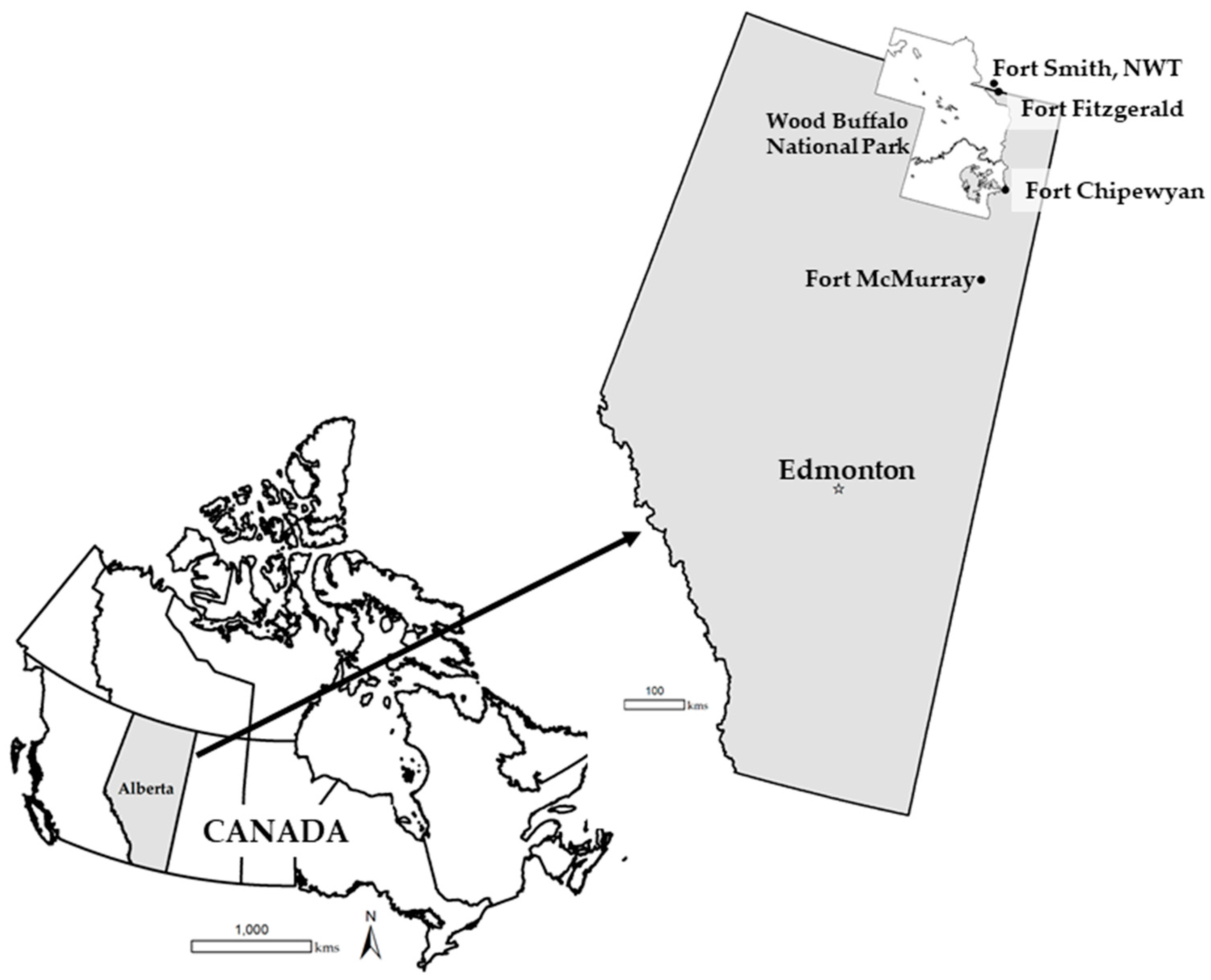
The Athabasca River flows from its glacial origins in the Canadian Rockies, then north across the province of Alberta, to the PAD in the Wood Buffalo National Park (WBNP), with the PAD being the largest inland freshwater delta in North America. Despite being the longest river (1231 km) in Alberta, there has been a disproportionate amount of research focused on the lower, more northerly, reaches of the river as it relates to Canada’s bitumen extraction from the oil sands region [
19]. In their systematic review of 386 publications focusing on the entirety of the Athabasca River over a 50-year period [
19], Ana Lima and Frederick Wrona determined that the majority of studies concentrated primarily on a single stressor (68.4%), especially factors pertaining to pulp and paper manufacturing and oil sands projects. Much of the research investigated chemical pollutants, although water withdrawals were another stressor that received some attention. Water withdrawals from the lower Athabasca River from oil sands activities in 2017 were 37.9 million m
3 (0.56% to 2.5%) of the measured flow rate during winter, and from 0.17% to 1.15% of the measured flow rate during ice-free periods (
www.environment.alberta.ca/apps/OSEM0). However, as with overall cumulative effects on the river, the total impact of oil sands mining on water availability is difficult to quantify. Associated removal of peatlands adjacent to the Athabasca River certainly impacts horizontal water flow from these wetlands into the river, but the volume of water lost to the river is unknown. Additionally, cumulative effects related to climate change and large hydro-electric projects (e.g., W.A.C. Bennett Dam in British Columbia on the Peace River) also play a major role in complex ecological relationships in the lower Athabasca River and its delta [
14,
18,
20]. As Kevin Timoney and his colleagues note [
4], the hydrological dynamics of the PAD are often oversimplified, given that the PAD is not a single delta, but rater three semi-independent sectors: the central main lakes, the delta of the Athabasca River, and the delta of the more northerly Peace River that flows northeast from British Columbia.
Adding to this complexity are the data gaps when assessing how current and future industrial water withdrawals might impact ecological needs within the lower Athabasca River and the PAD, especially as they relate to culturally and ecologically important species such as the American beaver (
Castor canadensis), American mink (
Neovison vison), muskrat (
Ondatra zibethicus), and North American river otter (
Lontra canadensis), all of which are semi-aquatic mammals. Applying computer simulations developed for one system and one industry (e.g., hydro-power production) [
21], might not be appropriate for the assessment of the ecological balance of another system where species interactions are strongly influenced by climate, historical events, and unique habitats. These four species of semi-aquatic mammals perform important roles, ecologically, economically, and culturally in many of the communities along the lower Athabasca River and in the PAD within and adjacent to the Wood Buffalo National Park. Muskrats, in particular, have played a central role in many of the Indigenous communities within the PAD and along the lower Athabasca River for millennia [
7,
8,
15,
17,
22]. Similarly, despite being a commonly trapped furbearer, beavers are highly valued for their ability to positively influence surface and groundwater storage [
23,
24,
25] and enhance the habitat for other species [
26]. In particular, river otters are strongly associated with beaver habitat [
27,
28,
29], both because of enhanced fish habitat and aquatic connectivity provided by beaver impoundments, and the ability for beaver lodges, bank dens, and downed woody debris to serve as resting and rearing sites for otters [
30]. In turn, river otters are an apex predator in freshwater systems, thereby aiding the ecological balance of the system. Similarly, mink are a key predator for muskrats, while also using muskrat huts and dens, and sometimes beaver lodges, as temporary resting cover instead of building their own structures [
31,
32]. The interdependence of these four species is well documented and highlights the multi-faceted nature of freshwater systems [
33].
For all four species, seasonal water levels play a critical role in population dynamics. Areas of open water that are at least 1 m to 2 m deep are generally beneficial. Overly high water levels could present difficulties for muskrats where key forage species are inundated and unable to grow. In winter, if water withdrawals create low water levels under the ice (e.g., 1 m deep), beavers and muskrats can be “frozen out” and are unable to access food during the winter [
23,
34], and mink and otters would have difficulty accessing open water for travel and foraging [
30]. Conversely, if water is discharged in winter, lodges, huts, and dens could be swamped, thereby resulting in the drowning of beavers and muskrats due to an inability to access air pockets under the ice. River otters also require air spaces to swim under the ice in winter to reduce energy loss on land [
30]. As such, regulated rivers pose difficult challenges to semi-aquatic mammals in northern climates, whether it be from temporal changes in water flow produced by hydro-electric development, or reduction in water availability from industrial water extraction throughout the year. Predicting and accurately reporting the impacts of these changes provides similar challenges [
35].
This paper presents a 2009 study (conducted by the author) that investigated how a proposed 15% increase in industrial water withdrawals from the lower Athabasca River for oil sands activities might influence beaver, muskrat, mink, and river otter populations in the downstream reaches of the river and the PAD within the WBNP. The study was done in the context of cumulative environmental effects and examined whether any models exist to quantify these effects [
35]. Additionally, this paper details how various data sources, including original data records, traditional knowledge (TK), and published and grey literature were accessed and synthesized from multiple sources, and how knowledge derived from the research was mobilized to aid decision-makers and key constituents in the government, industry, local communities, other associated organizations in the study area specifically, and the broader community as a whole.
3. Results
The original research question for the 2009 study remained true to the original request by CEMA: How might an increase in industrial water withdrawals from the lower Athabasca River impact semi-aquatic mammals, and do models exist that could quantify any impacts? My research team and I determined that there were no existing models that could be applied to the impact of increased water withdrawals on the semi-aquatic mammals in the lower Athabasca River and the PAD. Some research was available for the effects of water levels on muskrats in the PAD, but much of it was relative to population declines associated with the W.A.C. Bennett Dam on the Peace River, which feeds into the PAD from northern tributaries [
15]. Despite some research on muskrats, any existing studies were more retrospective in nature. Nothing similar existed for beavers, river otters, or mink. The synthesis of the data and literature that we found, combined with in-person interviews (some at trapper cabins on the PAD), presented a single reference source to aid future model development if desired. The original 2009 report [
35] provides detailed summaries, transcripts, and databases; however, a more detailed account of the data itself and the breadth of materials allows for an assessment of how information was mobilized within and beyond the research process.
3.1. Data Acquisition
My research team and I were able to acquire an extensive amount of data and information in all the categories specified in the original study design (i.e., original trapping records, aerial imagery, in-person interviews, and a review of the published and unpublished literature).
3.1.1. Trapping Records
Hudson Bay Company fur returns were available from 1821 to 1883. Although the records found in the Fort Chipewyan library were incomplete between the dates of 1821 to 1857, within the returns that were available in the library for this time period (1821 to 1883), there were 228,703 fur returns for muskrats, 31,728 for beavers, 1658 for mink, and 3127 for river otters recorded for the Athabasca District and Fort Chipewyan. It is important to note, however, that some of the beaver returns included coats, bonnets, cuttings, etc., thus making whole animal contributions difficult to quantify. There were more accurate tallies for two distinct periods ranging from 1858 to 1870, and 1871 to 1883 (
Table 1). It is of note that, given the central role of Fort Chipewyan trading posts in the northwestern fur trade, furs could have come from other locations and then brought to the forts to trade, thereby inflating the fur returns associated with the lower Athabasca River and the PAD.
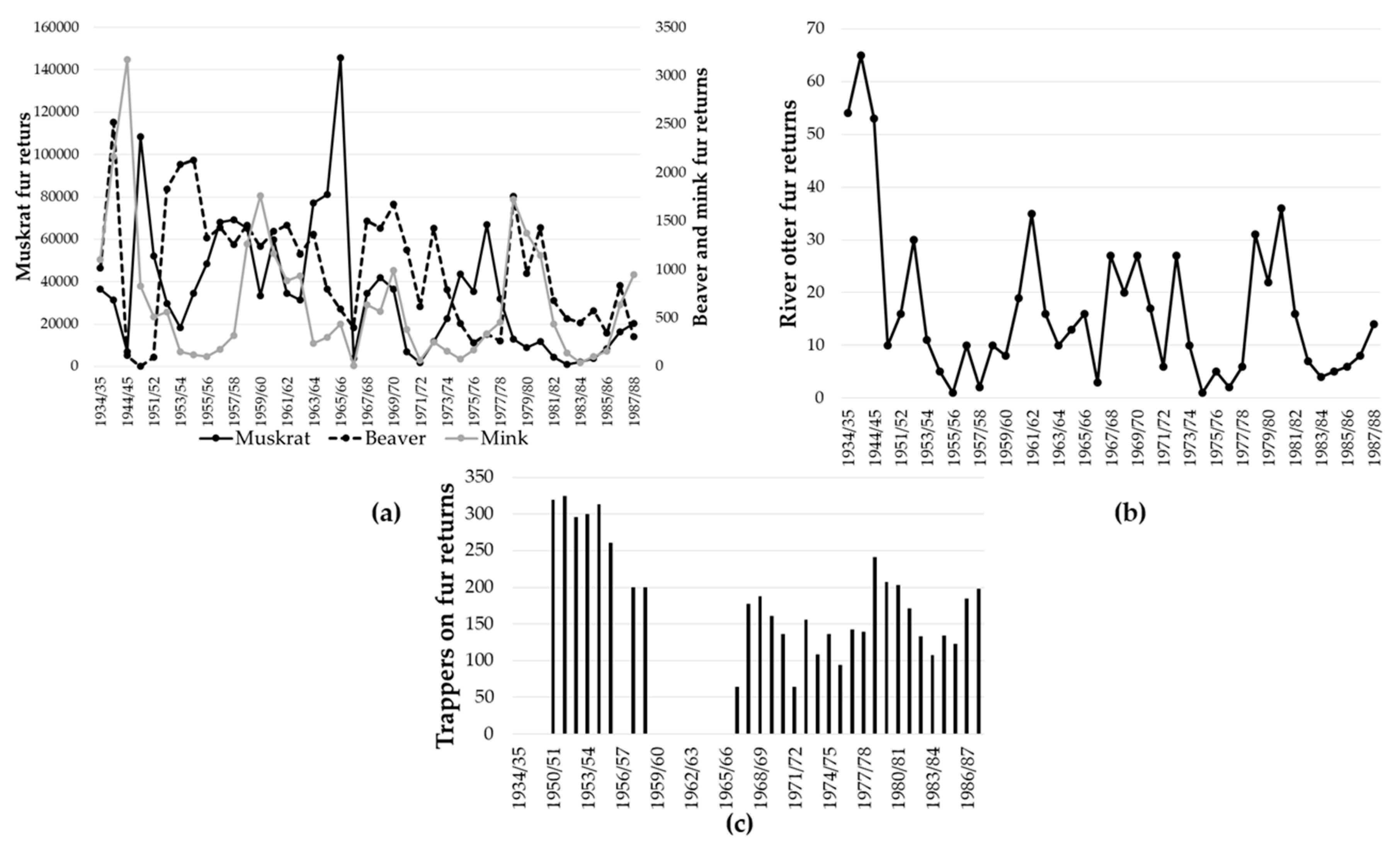
The WBNP trapping records extended from 1934 to 1988. Muskrats represented the largest number of fur returns during that time, with a peak of 145,713 furs reported in the 1965/1966 trapping season and a minimum in the 1982/1983 trapping season (
Figure 2a). Beaver fur returns reached their peak in 1940 (2520 furs), and a low of zero in the 1950/1951 trapping season (
Figure 2a), when beavers were thought to be extirpated from the park [
40]. Mink fur returns were lowest in the 1966/1967 trapping season and highest at 3169 in 1944/1945 (
Figure 2a). Otters were consistently found in lower numbers, with the largest number of otter fur returns (65 pelts) in 1940, and only one otter fur registered in both 1955/1956, and 1974/1975 (
Figure 2b). The number of trappers listed on the fur returns was 324 in 1951/1952, with the lowest number of trappers (
n = 64) in 1971/1972 (
Figure 2c), immediately after the filling of the Williston Lake reservoir associated with the W.A.C. Bennett Dam on the Peace River in 1971.
3.1.2. Aerial Photograph Database
We documented 1484 aerial photographs dating from 1949 to 2008; including 384 duplicates, (without duplicates = 1100 images). Images ranged from black and white to panchromatic, true color, false color, and infrared (
Table 2; see
Appendix B for a link to the full database). Despite the source agency, when evaluating the identified purpose of the images, the majority (35.8%) of the photographs were taken for forestry interests. The second highest identified application for the aerial photographs was for transportation planning (27.2%). Energy projects accounted for just under 10% of the images, although the use of the images in all categories likely would be interconnected. This data set represents the first tally for all images within a township width along the lower Athabasca River and the PAD over a 50-year period and allowed for a clear assessment of changes in surface water extent over time.
3.2. Trapper, Community Member, and Biologist Interviews
Of the people interviewed, 11 were trappers, 2 were long-term community members with close ties to local trapping history and its role in their community, and 1 was a wildlife biologist with over 20 years of experience in the region. Of the trappers, nine identified themselves as active trappers, despite having to work to supplement their income, which was not the case in earlier years. Within this group, four to five trappers lived on their traplines for >4 months of the year, with two trappers working their traplines for up to 9 months per year. Ages of the trappers ranged from their early 40s to their early 90 s, with a median age of 70 years old (IQR = 24). All trappers were from families who had trapped, sometimes over multiple generations, with six trappers living in Fort Chipewyan, two in Fort Smith, one in Fort Fitzgerald, and two in Fort McMurray (one of whom had formerly trapped along the Peace River and into the Peace-Athabasca Delta, and the other trapped near the mouth of the Athabasca River near Richardson Lake). Two trappers in the WBNP had formerly trapped along the Peace River (Trapping Area 1201) and had previously trapped in the PAD prior to the establishment of set trapping areas in 1947.
A notable decline in trapping over the past 30 to 40 years, either as a lifestyle or recreational pursuit, was a common theme in all of the interviews. During the interviews, there was some link to the impact of the residential school system on Indigenous trappers, but declining fur prices, declines in muskrat numbers after the opening of the W.A.C. Bennett Dam, and increased gas prices were consistently associated with the decline in trapping over time. With the decline in trapping as a whole, several trappers mentioned the lack of interest from younger generations (<30 years of age) to go out on the land. Trappers from Fort Chipewyan estimated that there were only five full-time trappers in the community at the time of the interviews (2009). Some community members still trapped recreationally. Trapping in Fort Smith (population ~2500) was even lower, with one trapper noting that only two trappers from that community were actively trapping for the past few years. Conversely, there were five to six active trappers (Indigenous and non-Indigenous) trapping full-time along the Athabasca River, with several others trapping as a “hobby”.
Of the trappers in the WBNP, all but three trapped beavers, muskrats (when available) almost exclusively, and fine furs (e.g., lynx, wolf, marten, fox, and fisher) when available. One trapper from Fort McMurray noted that river otters were commonly trapped, but when population imbalances were noted by trappers (e.g., only catching adults), the trapping community would stop trapping them altogether until population structures were restored. The older trappers (>60 years old) noted that their best years of trapping were in the 1960s, prior to the construction of the W.A.C. Bennett Dam on the Peace River near Hudson’s Hope, BC. In the 1960s, trapping returns for a single trapper in the PAD could range from 3000 to 4000 muskrats per year. Now muskrats are too difficult to find to warrant any concentrated trapping. A full account of trapper comments is in
Appendix A of Hood, Bromley, and Tiitmamer Kur’s 2009 report [
35]. All comments are anonymous to meet ethics requirements.
3.3. Literature Review
Over the course of the study, we obtained and synthesized over 206 publications, of which 101 were formally cited in the final 2009 report [
35]. Of the full suite of articles/reports (
n = 206), 35% (
n = 72) were peer-reviewed articles pertaining to species biology, hydrological modelling, and ecological processes in the study area, 56.3% (
n = 116) were “grey literature” (unpublished reports and similar documents), 5.3% (
n = 11) were books (mainly book chapters), and 3.4% were graduate theses (
n = 7). Of the peer-reviewed articles, approximately half (51%,
n = 37) addressed species ecology, while a third (33.3%,
n = 24) addressed various aspects of riverine hydrology (e.g., flooding, ice jams, modeling water management). Within the grey literature, we obtained and synthesized 105 unpublished/technical reports, of which 35 documents (30.2%) were cited in the 2009 report, with an additional 13 documents not directly cited in the report (11.2%), but still providing raw data for the tabulation of fur returns for the WBNP. As a whole, all of the documents provided important context for wildlife ecology (
n = 67, 57.8%), and hydrology (
n = 46, 40%), including water quantity and quality.
Two reports within the grey literature tabulated and referenced data from several inaccessible consultant reports that contained species-specific survey data and inventories from 1970 to 2007 in the oil sands region [
41,
42] All but one [
43] of the 53 consultant reports cited were specific to environmental impact assessments/reviews (ER) for oil sands projects. Of the ERs, 73.6% (
n = 39) were written by environmental consultants who had conducted the wildlife surveys for various oil companies (
n = 21 companies), while 24.5% (
n = 13 reports) were ERs submitted to the government by industry as part of the formal project approval process. Wildlife surveys included in the ERs submitted by industry, however, were conducted by environmental consultants as supporting data for the final ER. Suncor Energy (
n = 12 reports, 23.5%) and Syncrude Canada Ltd. (
n = 11 reports, 21.6%) hired the majority of consultants who then wrote the reports for individual wildlife surveys. Most reports documented more than one species of semi-aquatic mammal. In
Appendix B in the 2009 study [
35], I further categorized these surveys into species-specific tables, along with their original source references.
From 1970 to 2006, there were 30 beaver surveys, all but one [
35] conducted as part of proposals for oil sands projects. The one survey not associated with oil sands projects was a provincial analysis of fur production records from 1970 to 1975 [
43], which included all four semi-aquatic furbearer species. From 1970 to 2006, there were 27 muskrat surveys, all but one connected to major oil sands projects, and the other being the previously mentioned trapline survey [
35]. River otter surveys were quantified in 35 studies and, as with beavers and muskrats, all but one was associated with oil sands projects. Lastly, 35 studies quantified mink surveys in the study area, with all but one [
35] associated with oil sands development.
The documents pertaining to beaver, muskrat, river otter, and mink that were specific to the lower Athabasca River, the PAD, or the WBNP (with park-wide data that included the PAD) comprised 17.4% (
n = 36) of the documents surveyed for the study. Of these, only one was peer-reviewed (a river otter study) [
30], while the rest were from the grey literature found in the two Parks Canada libraries. Of the grey literature, 42.9% (
n = 15) of the reports were about muskrats (13 of which focused exclusively on the PAD). Six reports (17.1%) focused exclusively on beavers (with two of those reports specific to the PAD and four specific to the WBNP as a whole), and only two reports were specific to mink, one for the lower Athabasca River and one for the PAD. There was no grey literature pertaining exclusively to river otters, although there were 12 reports (34.3%) that included all four species together (one specific to the lower Athabasca River, five for the PAD, and six for the WBNP as a whole).
3.4. Knowledge Translation and Mobilization
3.4.1. Dissemination of Research beyond Traditional Academic Venues
The formal requirements from the funding agency (CEMA) for the 2009 research were a comprehensive technical report [
35] and presentation of the final results to their board, to whom I submitted three printed copies and an electronic version of the final 91-page report on December 13, 2009. The oral presentation of the research was on December 4, 2009. As late as 2014, the report remained in CEMA’s print library, but was later on CEMA’s online library, although it was originally only accessible through a public login process. By 2018, it was openly available without login requirements (
http://library.cemaonline.ca/ckan/dataset/2009-0017). I also provided two printed reports, one for the Fort Smith and one for the Fort Chipewyan Parks Canada libraries, and a digital copy to the park ecologist in the Wood Buffalo National Park (an ex-officio member of CEMA). At the time, the aerial photograph database (
Appendix B) was provided on a computer disk, as well as through email. Rather than receiving individual copies, people interviewed during the project preferred that the report go directly to their affiliated community councils/organizations. As such, I also mailed printed reports to the Mikisew Cree First Nation, Athabasca Chipewyan First Nation, Smith’s Landing First Nation, and the Metis Nation of Alberta Local #125, all of whom represented individual Indigenous trappers who had participated in the study. Sending these reports was not in the research contract agreement, but we considered it to be one of the more important aspects of initial research dissemination. Between 2010 and 2013, several environmental consultants requested digital copies of the report to use as a reference for their research and monitoring work in the lower Athabasca River and the PAD.
From 2008 to 2014, I presented the research beyond academia at eight different venues that ranged from public talks and multi-stakeholder forums to traditional academic conferences (
Table 3). The Unwrap the Research Conference in Fort McMurray, AB in 2010 was purposefully designed by Dr. Brenda Parlee of the University of Alberta to share research conducted in lower Athabasca and the PAD directly with affected parties in or nearby their home communities. The one talk that brought the research directly to the community that was most engaged in my 2009 research (Fort Chipewyan, Alberta) was the Peace Athabasca Delta Environmental Monitoring Program Forum in 2014. This talk served as the keynote address to open the Forum, in which community members, research scientists, Parks Canada staff, federal and provincial employees, and the general public, shared research and then worked collaboratively in break-out groups to address key issues of concern for the PAD and the lower Athabasca River. The results of the Forum were later provided to all participants by the WBNP in a summary report [
44]. The report, combined with these presentations, helped increase public awareness of the ecological, economic, and cultural context of the area, past and present.
3.4.2. Uptake, Community Access, and Engagement of the Research beyond Academia
Relative to the uptake of the 2009 research by local communities and non-academic parties living and working within the study area, there were several reports generated by government staff and consultants that drew on data sets and information within our final 2009 report [
35], which then helped inform future policy and practice. For example, in 2016, Parks Canada conducted an operational review of its ecological integrity monitoring program within the WBNP [
45]. In particular, the synthesis of muskrat data, and water level predictions helped inform future research directions within the PAD, which is [
7,
8] a topic that remains of great concern for the community of Fort Chipewyan. One of the two academic studies within the WBNP [
8] requested the use of the muskrat database that my team and I created for the 2009 research.
Our 2009 research was also noted in the 2011
Athabasca Watershed Council State of the Watershed Report: Phase 1 [
46]. Additional information for the report was presented on an associated CD. Our CEMA research helped inform contracted research on the potential impacts of beavers on the success of oil sands reclamation for CEMA in 2013 [
47]. In this case, given my past experience with the 2009 research and additional studies specifically on beavers, the authors also asked that I peer-review their report prior to its final submission to CEMA, thus aiding the contextualization of the research relative to new research questions [
38].
3.4.3. Implementation to Inform Organizational Decisions
As per Section 12 (2) of the Canada National Parks Act [
48], “At least every two years, the Minister shall cause to be tabled in each House of Parliament a report on the state of the parks and on progress made towards the establishment of new parks”. As noted in the previous sections, Parks Canada incorporated the 2009 research into its 2016 operational review of ecological integrity monitoring for the WBNP, and further highlighted the semi-aquatic mammal research at their 2014 Peace Athabasca Delta Environmental Monitoring Program Forum in Fort Chipewyan, AB. The opening remarks and presentations at the Forum set the stage for its key objectives: (1) identify the efficacy of current monitoring activities relative to ecological vulnerabilities in the PAD, (2) identify additional monitoring required to address these vulnerabilities, and (3) identify possible (and improved) collaborations, communication approaches, and ways to share and incorporate Traditional Knowledge [
44]. During the rotating break-out group sessions during the two-day forum, participants focused on three specific themes: (1) contaminants, (2) water quantity and hydrology, and (3) “bringing Western Science and Traditional Knowledge together” [
44], (p. 6). The results of this forum then helped inform policies within the WBNP, provided a venue to expand perspectives and provided a training opportunity to new park staff, and potentially leveraged new program funding, each of which is a metric defined in the co-produced pathway to impact framework outlined by David Phipps and his colleagues [
38].
3.4.4. Impact Through Utilization of the Research to Effect Meaningful Change within the Community
The long-term impact of the research was more difficult to identify, although the final 2009 report was noted in the Mikisew Cree First Nation’s submission of their petition to the World Heritage Committee (WHC) to request that the WBNP be placed on the
List of World Heritage in Danger [
49]. Rather than just address the decline of muskrats, as is often done to highlight declining water levels in the park, their petition noted our findings for all four species of semi-aquatic mammals that would be impacted by ongoing declines in water levels. The WHC did not include the WNBP on this list when the petition was submitted in 2017; however, ongoing consideration of its inclusion continues to be highlighted in the Canadian media.
4. Discussion
Rapid industrial change creates challenges in accurately assessing associated environmental and cultural impacts in an equally timely manner, particularly relative to the energy sector, where almost 140,000 million ha of boreal forest have been impacted through the mining of bitumen in northern Alberta, Canada over the past few decades [
50,
51]. The interaction of resource development projects with diverse and dynamic river systems creates added complexity, especially in areas where even basic ecological studies are rare or completely lacking. Such is the case with the lower Athabasca River and the PAD in northeastern Alberta, where semi-aquatic mammals have played important ecological and cultural roles for millennia, yet have faced population declines due to overharvesting and habitat alteration. Yet published literature for key species of semi-aquatic mammals in this area was almost non-existent [
30], although two additional peer-reviewed studies on muskrat and based in the PAD have been published since 2018 [
7,
8]. Much of the research and monitoring of semi-aquatic mammals remains in the grey literature, with most of these documents housed in the Parks Canada libraries and filing cabinets in Fort Smith and Fort Chipewyan, which are generally inaccessible to the public. Of these unpublished documents, the majority were specific to muskrat populations in the PAD, especially following the establishment of the W.A.C. Bennett Dam and subsequent changes in flood pulses and water levels in the Peace River. Of note is that finding these documents within the WBNP libraries required my research team and I to physically examine the relevance of every single document on the shelves and tables in the two libraries because of a lack of up-to-date paper-based or electronic library database. A similar process occurred with documents housed in filing cabinets in storage areas.
In Parks Canada, and many other provincial and federal departments and agencies, it is very unusual to have a dedicated librarian and, although each park has a library, its organization and maintenance is either done as an additional secondary duty by an administrative assistant or becomes a side project for someone with an interest in library resources. Very seldom is there distinct library funding, often due to budget and staffing constraints. However, the documents in these libraries provided major contributions to the final 2009 report for CEMA [
35] and allowed once forgotten data to resurface. Although we found no existing models directly applicable to the impact of increased water withdrawals on semi-aquatic mammals in the oil sands region, the variables required to develop a model were compiled in our final report, in no small part due to research, monitoring, and raw data contained within the grey literature and other unpublished documents (e.g., fur records, aerial photograph databases).
Although some scholars suggest that a solution to the increased use of the grey literature would be “to integrate access to grey literature within the databases that scholars regularly consult” [
52] (p. 4), much of the grey literature we found that was applicable to the question of potential impacts of water withdrawals on semi-aquatic mammals in the lower Athabasca River and the PAD was not readily available to academic scholars. Indeed, without the author’s previous knowledge and experience as a former Parks Canada employee, the lack of awareness of these libraries and associated archived files would have been an immediate barrier to knowledge mobilization in its initial stages (“Research”) as defined by David Phipps and his colleagues [
38]. The reduction and elimination of various government libraries and many of their holdings between 2014 and 2015 by Canada’s federal government further limited the mobilization of invaluable knowledge stored within these libraries [
53,
54]. With many of the older reports used in our study that were produced with typewriters rather than computers, the loss of the historical ecology of the area would be permanent. Handwritten documents, including fur tallies, also would face the same fate. Projects, such as the creation of the
Antarctic Bibliography in 1963, where data and publications (primarily grey literature) were copied to microfiche for preservation, provide a powerful example of foresight relative to knowledge mobilization for current and future scientists [
55]. Now that microfiche is difficult to access and read, the National Science Foundation has created the
Polar Digitization project to make the full-text grey literature materials from the
Antarctic Bibliography (including rare government reports) openly available electronically [
55]. Knowledge is impossible to mobilize if key reports and the historical context they document are not accessible; open electronic access ensures broad availability within and external to academia.
Much like the grey literature, peer-reviewed literature and academic books provided critical ecological information about the four species of interest: beaver, muskrat, river otter, and mink. However, as with hydrological models, the peer-reviewed literature, in particular, was often specific to a particular study area that was very different from boreal rivers and deltas of northern Alberta. Information with the greatest applicability to the lower Athabasca and the PAD, not surprisingly, came from the local trappers, residents, parks staff, and biologists. Fikret Berkes [
56] notes that the complexity of socio-ecological systems, similar to those found in the lower Athabasca River and the PAD, results in knowledge that is dispersed among a varied hierarchy of groups and individuals, which then allows for management decisions to be assessed and mobilized at different temporal and spatial scales. In the WBNP and the surrounding communities, the Peace Athabasca Delta Environmental Monitoring Program (PADEMP) brings together traditional knowledge holders, scientists, and government personnel (including participants from Indigenous governments) to collaboratively achieve long-term monitoring and reporting on the ecological health of the PAD in particular, and the park more generally. Along with integrating Western Science and Traditional Knowledge, the PADEMP aims to provide open communication within and beyond the core group of participants. Its members include six First Nations, four Métis Associations, Parks Canada (WBNP), three additional federal departments, the governments of the Northwest Territories and Alberta, and two non-governmental organizations. Within this group, there is a broad age range, which helps expand the mobilization of knowledge across generations. As noted previously, the average age of the trappers interviewed in our study was 70 years old, and a common theme was the lack of youth engagement in land-based activities, trapping in particular. The opportunity to share perspectives within the PADEMP forum provides a means to foster a culture of co-management among groups, as well as intergenerational connections within groups.
When examining the movement of knowledge over a broad sociological landscape, decision-making is less impacted by scientific studies than expected [
57]. Vivian Nguyen and her colleagues also note that it can take long periods of time before one really knows the true impact of knowledge on policy development or similar societal changes [
57]. The length of time from the initiation of a scientific study to peer-review and publication can take years, which tends to provide important knowledge and possible solutions long after immediate needs for that research have passed (e.g., annual water allocation decisions without a current understanding of hydrological changes and impacts of past decisions). In the case of the 2009 study described in this paper [
35], there was an eight-month turn around to assess how increasing industrial water withdrawals from the Athabasca River by an additional 15% would impact a suite of semi-aquatic mammals, all of which have different ecological requirements and niches. It required a multi-faceted approach to provide diverse pieces of the puzzle that might one day evolve into a workable model. Although an empirical model was not readily available in either the academic or grey literature, traditional knowledge, historical data, and varied literature sources provided a strong indication that further declines in water levels, especially timed outside of ecological norms, would add to the myriad of cumulative effects already experienced by these species and the people who depend on them. Over time, the impact of the study has slowly revealed itself within the local communities, consultancies, and academia. One example occurred after a presentation at the PADEMP Forum in Fort Chipewyan when people from the community, many of whom had participated or assisted with the interviews, expressed distinct appreciation that their lived experiences were included in the presentation in a manner that brought the cumulative body of knowledge back to the communities where solutions must be co-produced among different organization and perspectives for real change to take place.
Knowledge mobilization can only happen when those creating or translating it are able to speak. Academics possess the ability to retain intellectual property rights, and academic freedoms that provide a safe and open forum to present research findings through broad avenues. In the case of the semi-aquatic mammal study, these privileges allowed me to distribute the final CEMA report when it was not otherwise available. However, the manner in which knowledge is shared must be accessible beyond academic norms in presentation style and discourse. It must translate to the audience. Dissemination of the findings was the most robust aspect of knowledge mobilization in the case of this study. Uptake, implementation, and impact were much harder to quantify, yet are arguably more important for change. Therein lies the challenge for effective knowledge mobilization, how to assess and measure the true impact of research over different temporal and spatial scales, especially when rapid solutions are required for complex problems.


