Mapping Land Cover Change over a 25-Year Period (1993–2018) in Sri Lanka Using Landsat Time-Series


Abstract
:1. Introduction
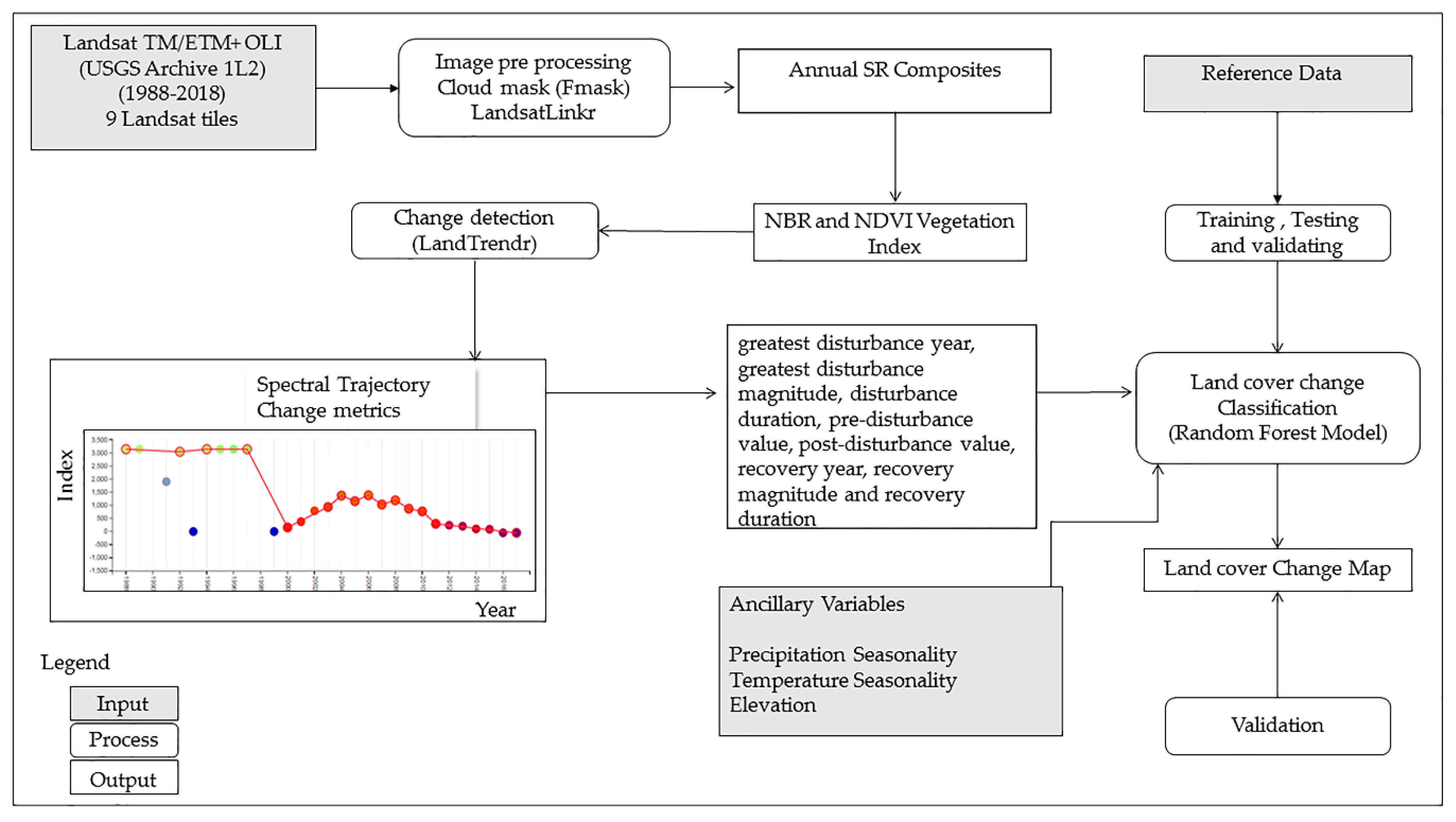
2. Materials and Methods
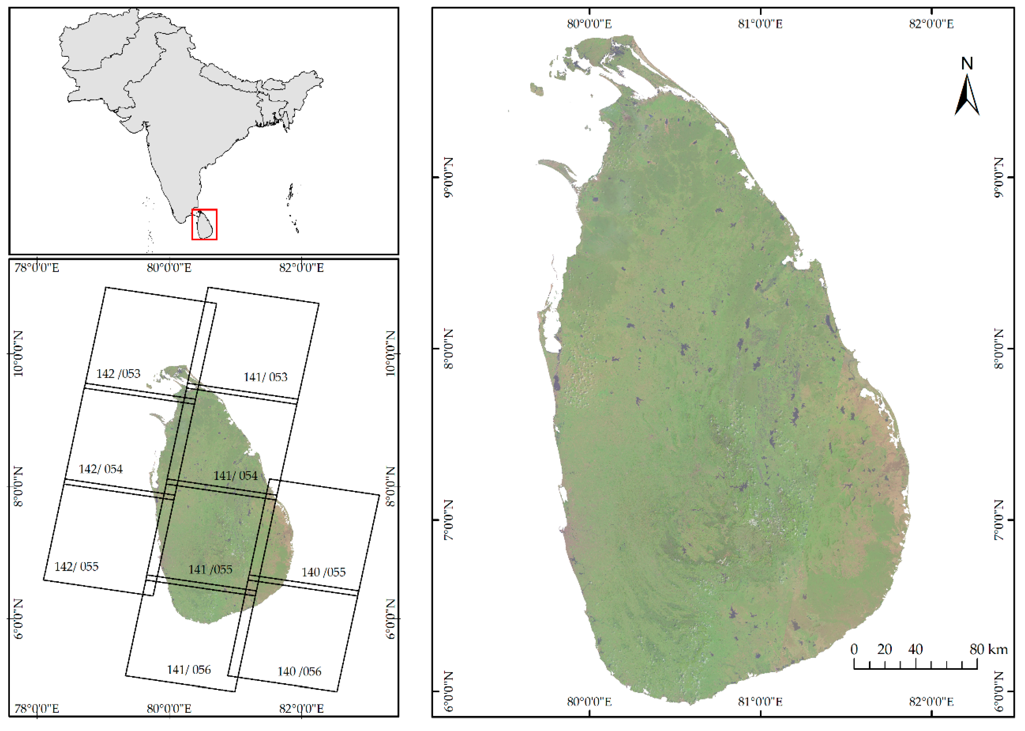
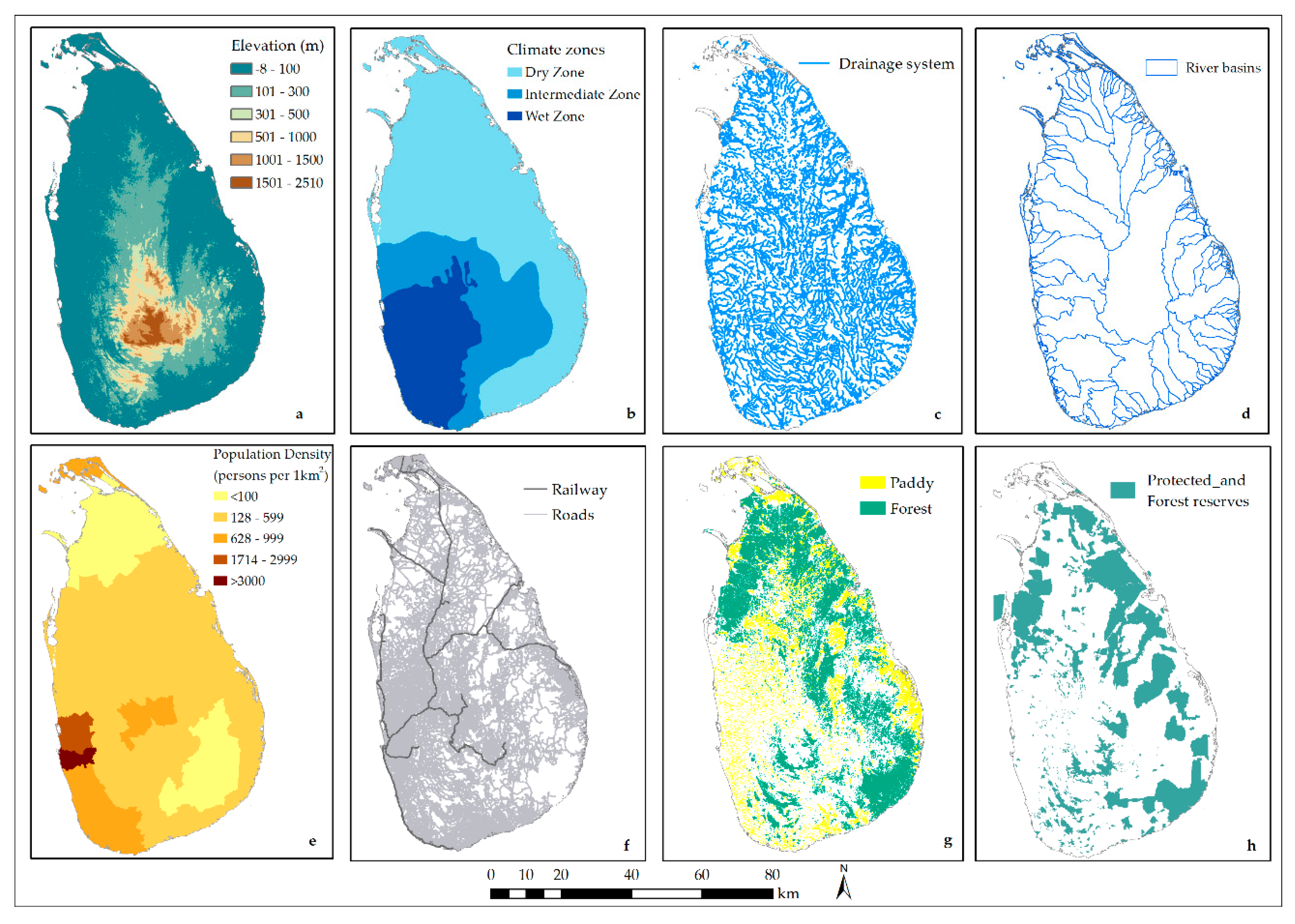
2.1. Study Area
2.2. Landsat Imagery and Spectral Indices
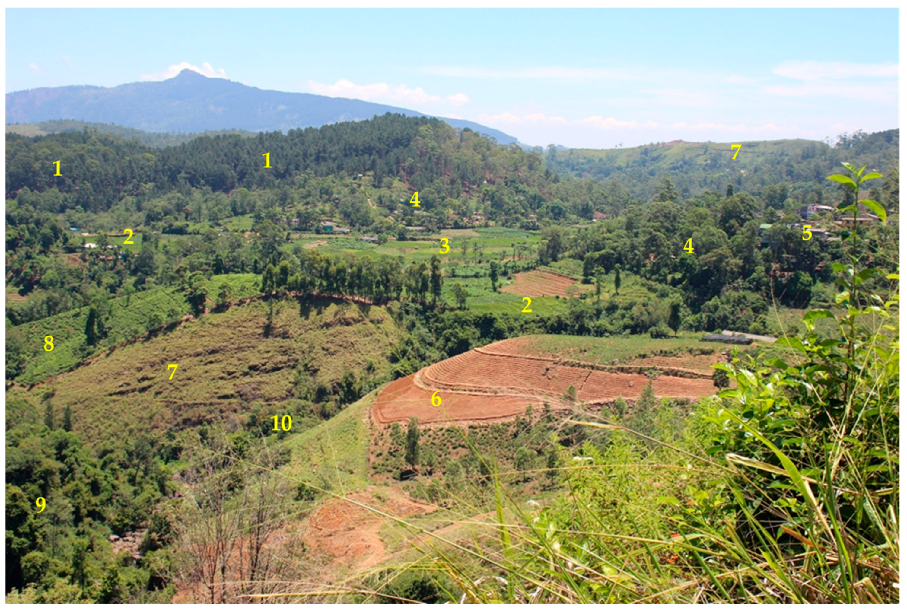
2.3. Reference Data, Classification and Validation
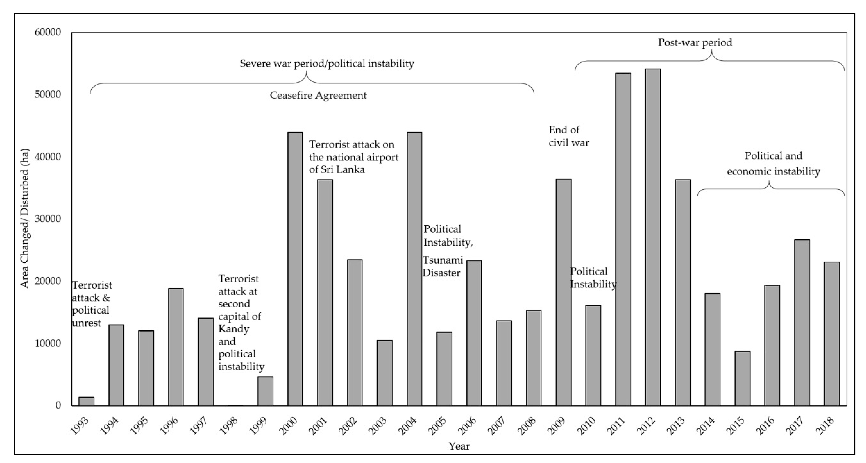
3. Results
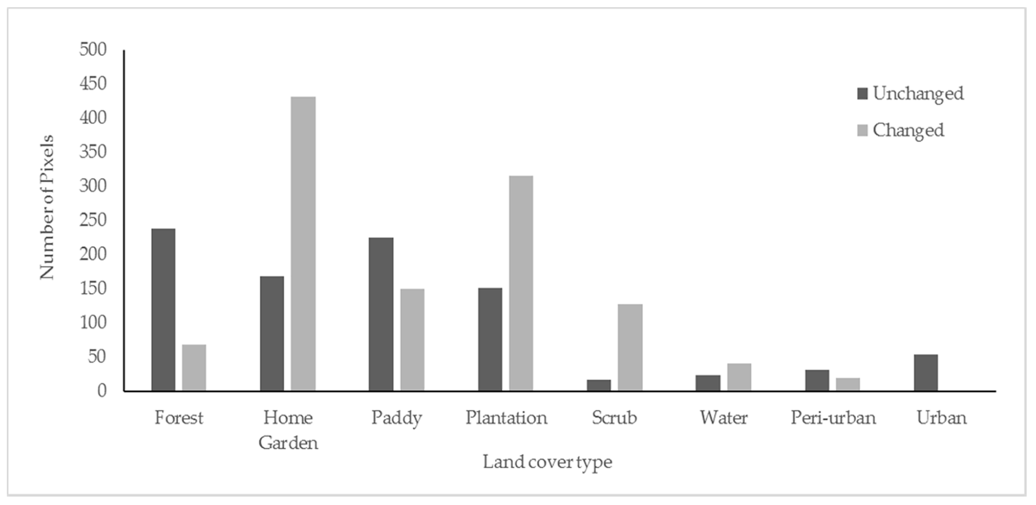
3.1. Reference Data, LULCC Map and Accuracy
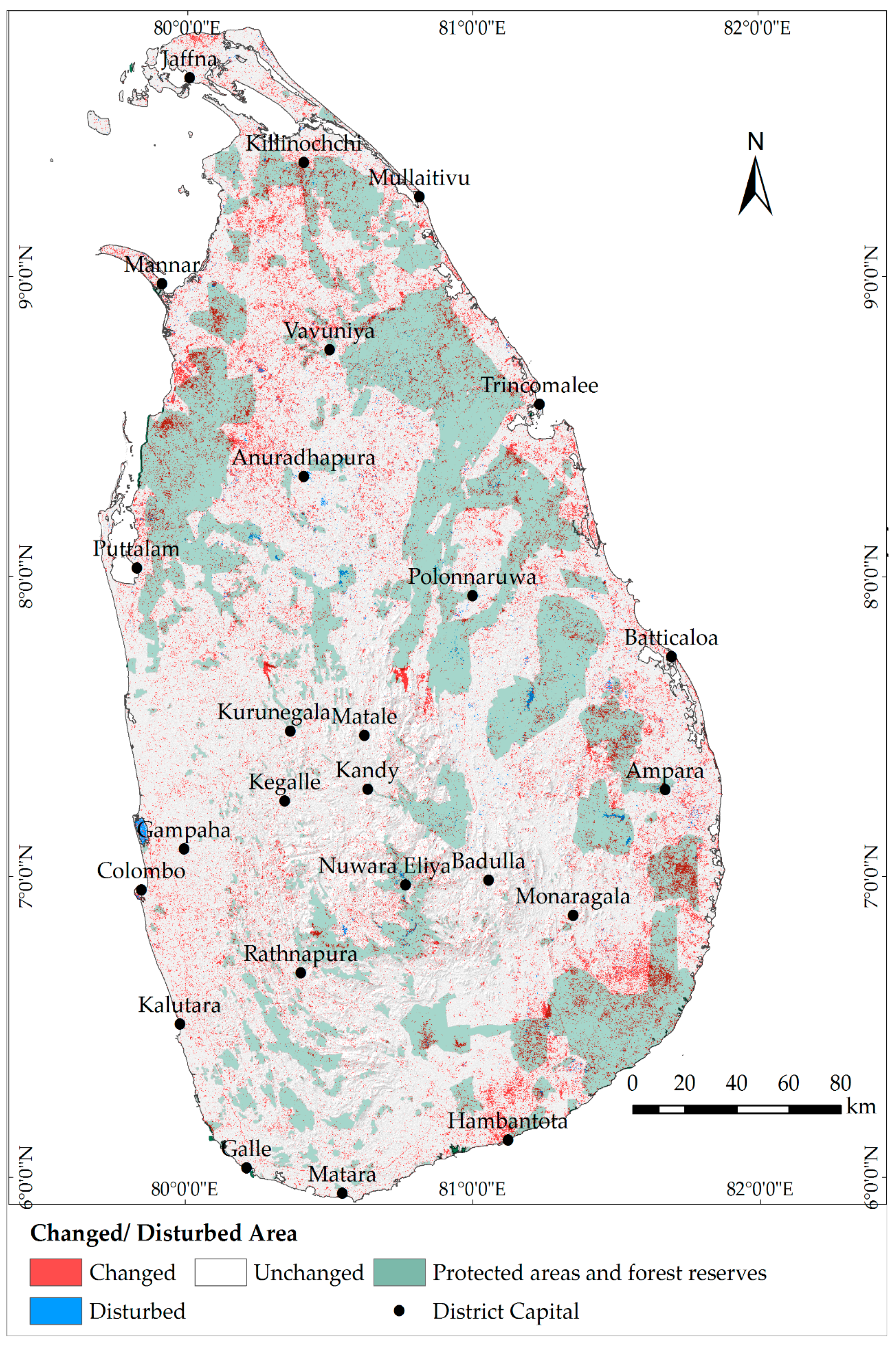
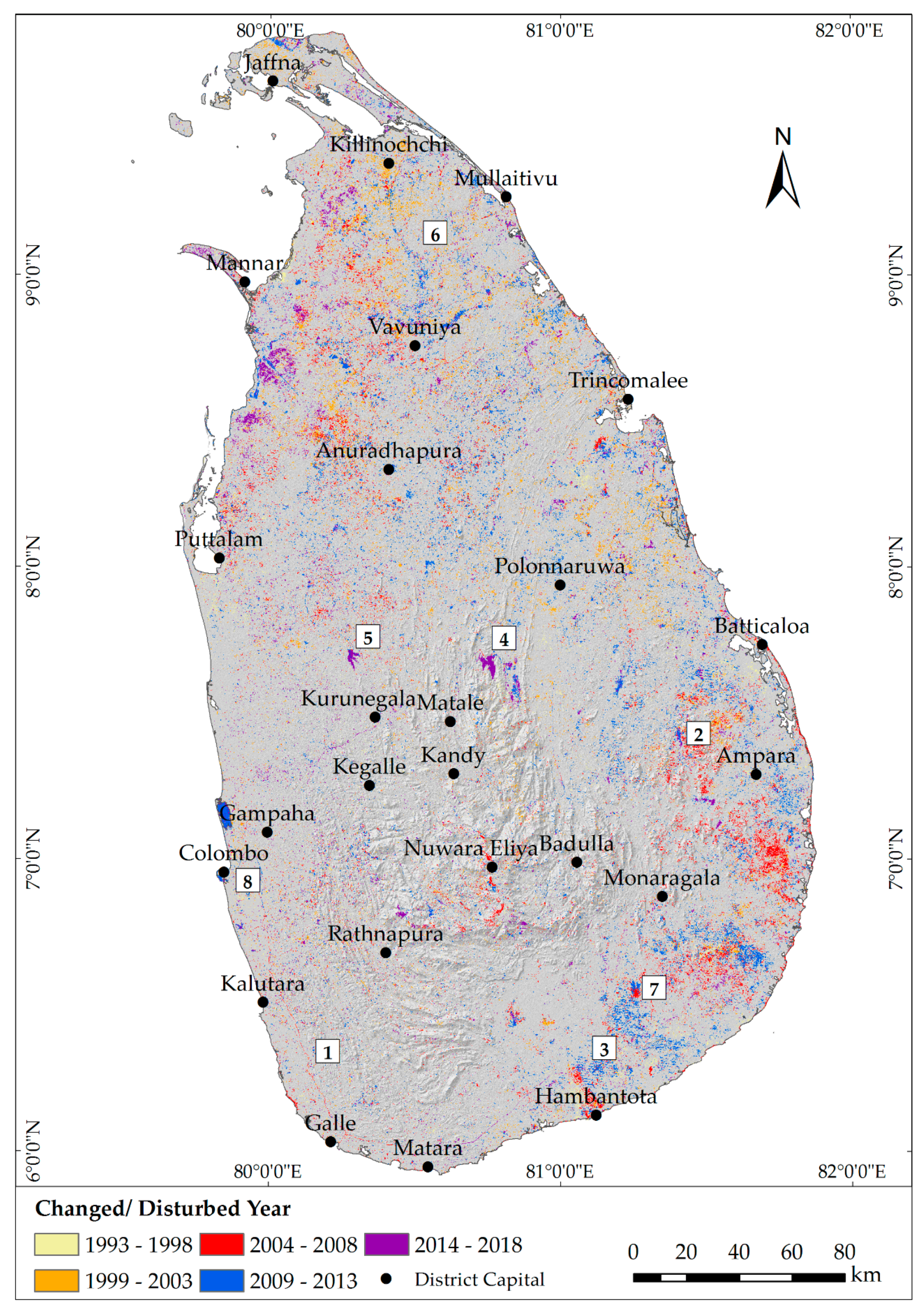
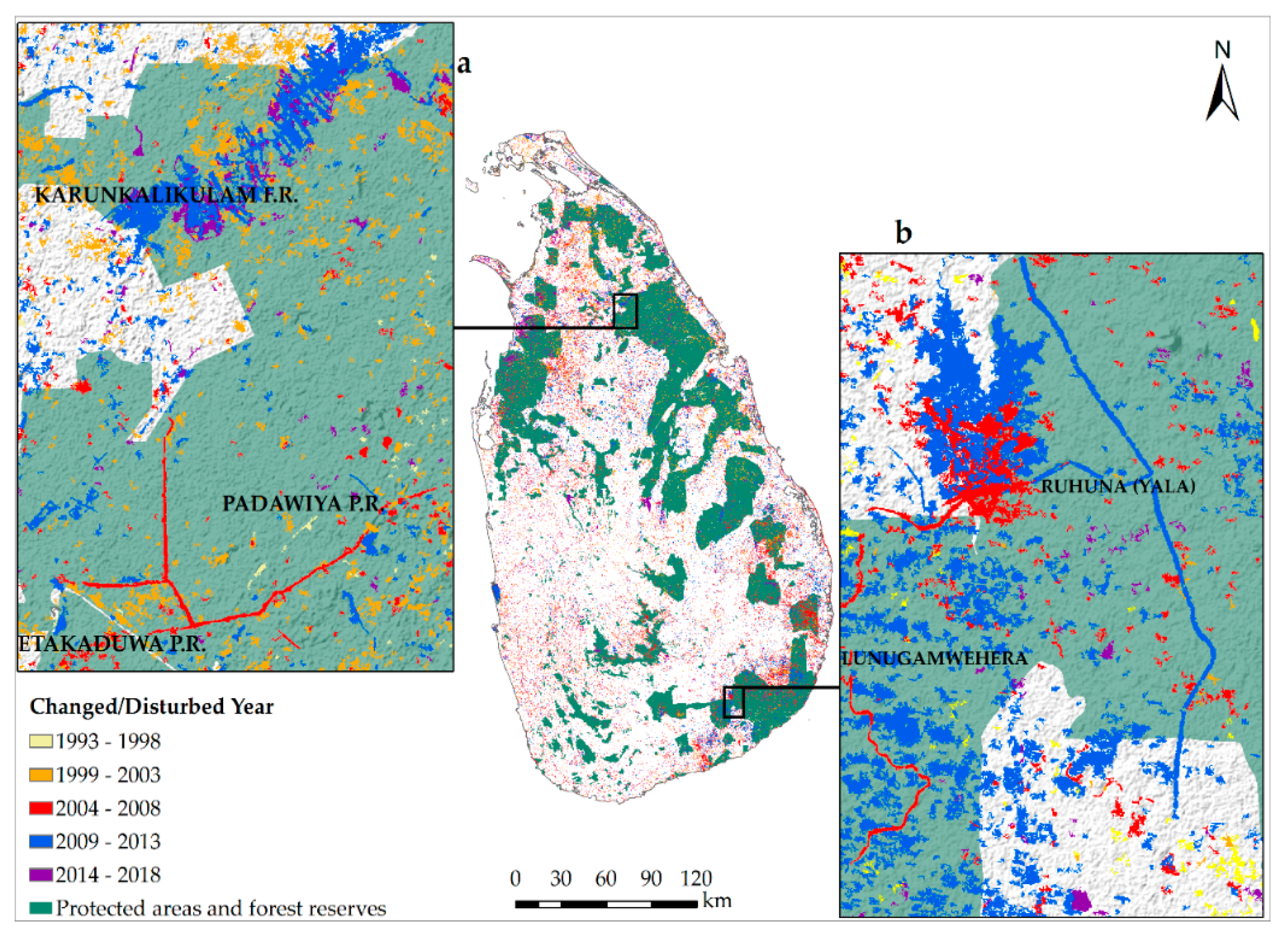
3.2. LULCC and Protected Areas
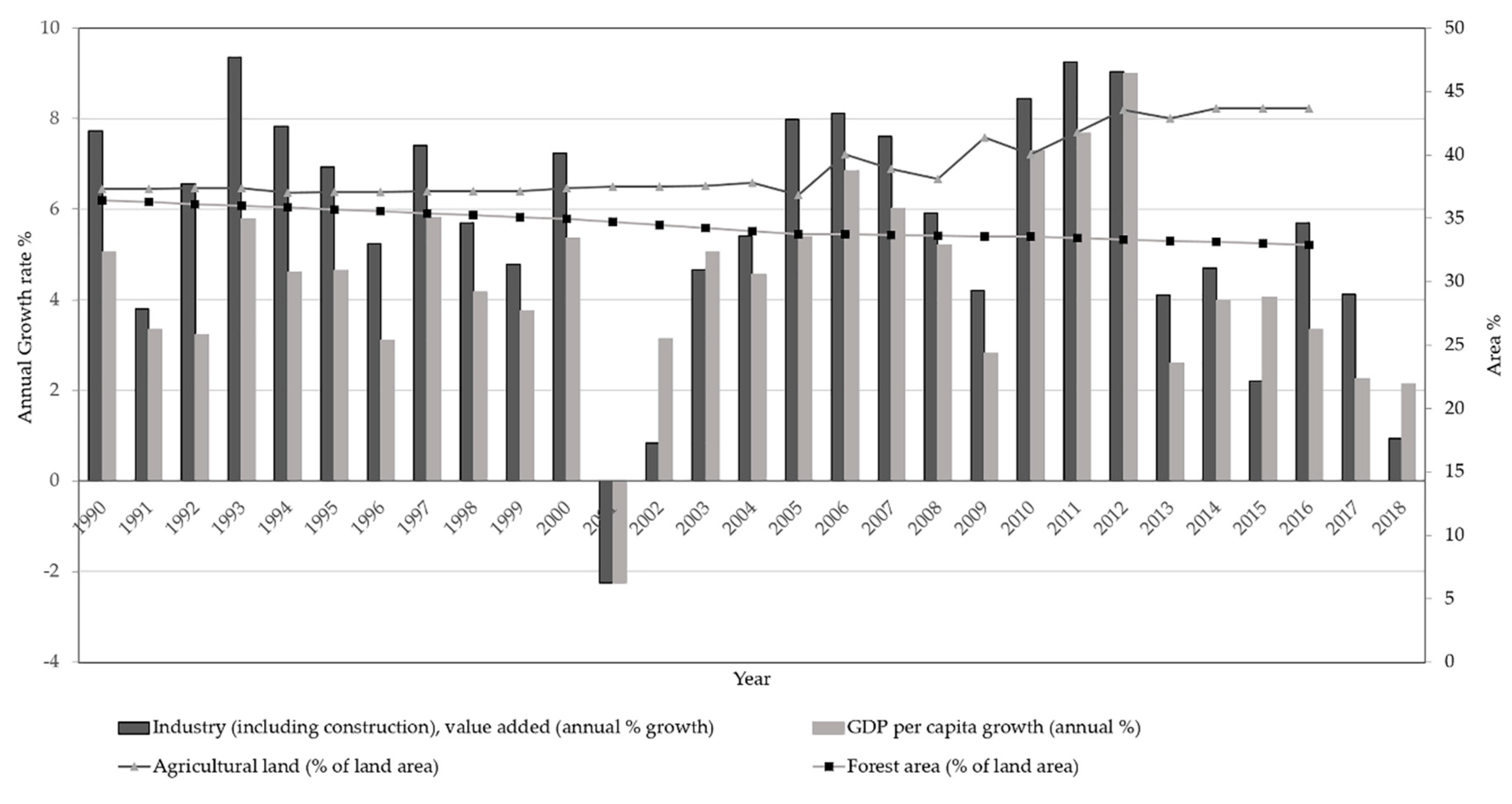
4. Discussion
5. Conclusions
Supplementary Materials
Author Contributions
Funding
Acknowledgments
Conflicts of Interest
References
- Butchart, S.; Walpole, M.; Collen, B.; Van Strien, A.; Scharlemann, J.; Almond, R.; Baillie, J.E.; Bomhard, B.; Brown, C.; Bruno, J.; et al. Global biodiversity: indicators of recent declines. Science 2010, 328, 1164–1168. [Google Scholar] [CrossRef]
- Kennedy, R.E.; Yang, Z.; Braaten, J.; Copass, C.; Antonova, N.; Jordan, C.; Nelson, P. Attribution of disturbance change agent from Landsat time-series in support of habitat monitoring in the Puget Sound region, USA. Remote Sens. Environ. 2015, 166, 271–285. [Google Scholar] [CrossRef]
- De Giglio, M.; Allocca, M.; Franci, F. Multitemporal analysis of Landsat images to detect land use land cover changes for monitoring soil sealing in the Nola area (Naples, Italy). In Proceedings of the Earth Resources and Environmental Remote Sensing/GIS Applications VII, Edinburgh, UK, 26–29 September 2016. [Google Scholar]
- Li, M.S.; Mao, L.J.; Shen, W.J.; Liu, S.Q.; Wei, A.S. Change and fragmentation trends of Zhanjiang mangrove forests in southern China using multi-temporal Landsat imagery (1977–2010). Estuar. Coast. Shelf Sci. 2013, 130, 111–120. [Google Scholar] [CrossRef]
- Zoran, M.; Zoran, L.F.; Dida, A.; Dida, M.R. Climate changes and their impacts on Romanian mountain forests. In Proceedings of the Remote Sensing for Agriculture, Ecosystems, and Hydrology XIV Conference, Edinburgh, UK, 23 October 2012. [Google Scholar] [CrossRef]
- Kamwi, J.; Cho, M.; Kaetsch, C.; Manda, S.; Graz, F.; Chirwa, P. Assessing the Spatial Drivers of Land Use and Land Cover Change in the Protected and Communal Areas of the Zambezi Region, Namibia. Land 2018, 7, 131. [Google Scholar] [CrossRef] [Green Version]
- Vermote, E.; Justice, C.; Claverie, M.; Franch, B. Preliminary analysis of the performance of the Landsat 8/OLI land surface reflectance product. Remote Sens. Environ. 2016, 185, 46–56. [Google Scholar] [CrossRef]
- Souza-Filho, P.W.M.; de Souza, E.B.; Silva Júnior, R.O.; Nascimento, W.R., Jr.; Versiani de Mendonça, B.R.; Guimarães, J.T.F.; Dall’Agnol, R.; Siqueira, J.O. Four decades of land-cover, land-use and hydroclimatology changes in the Itacaiúnas River watershed, southeastern Amazon. J. Environ. Manag. 2016, 167, 175–184. [Google Scholar] [CrossRef]
- Shen, G.; Ibrahim, A.N.; Wang, Z.; Ma, C.; Gong, J. Spatial–temporal land-use/land-cover dynamics and their impacts on surface temperature in Chongming Island of Shanghai, China. Int. J. Remote Sens. 2015, 36, 4037–4053. [Google Scholar] [CrossRef]
- Park, J.K.; Um, D.Y. Time series analysis of land cover and land surface temperature change using remote sensing method in Seoul. Int. J. Appl. Eng. Res. 2015, 10, 39201–39207. [Google Scholar]
- Dissanayake, S.; Asafu-Adjaye, J.; Mahadeva, R. Addressing climate change cause and effect on land cover and land use in South Asia. Land Use Policy 2017, 67, 352–366. [Google Scholar] [CrossRef]
- Lu, D.; Hetrick, S.; Moran, E.; Li, G. Application of time series landsat images to examining land-use/land-cover dynamic change. Photogramm. Eng. Remote Sens. 2012, 78, 747–755. [Google Scholar] [CrossRef] [Green Version]
- Hansen, M.C.; Loveland, T.R. A review of large area monitoring of land cover change using Landsat data. Remote Sens. Environ. 2012, 122, 66–74. [Google Scholar] [CrossRef]
- Mitra, A.P.; Mitra, A.P.; Sharma, C. Global Environmental Changes in South Asia a Regional Perspective; Capital Pub. Co.: New Delhi, India, 2010. [Google Scholar]
- Mapa, R.; Kumaragamage, D.; Gunarathne, W.; Dassanayake, A. Land use in Sri Lanka: Past, present and the future. In Proceedings of the 17th World Congress of Social Science (WCSS), Bangkok, Thailand, 14–21 August 2002. [Google Scholar]
- Suthakar, K.; Bui, E.N. Land use/cover changes in the war-ravaged Jaffna Peninsula, Sri Lanka, 1984-early 2004. Singap. J. Trop. Geogr. 2008, 29, 205–220. [Google Scholar] [CrossRef]
- Subasinghe, S.; Estoque, R.C.; Murayama, Y. Spatiotemporal analysis of urban growth using GIS and remote sensing: A case study of the Colombo Metropolitan Area, Sri Lanka. ISPRS Int. J. Geo-Inf. 2016, 5, 197. [Google Scholar] [CrossRef] [Green Version]
- Hapugala, G. Projecting land use transitions in the Gin Catchment, Sri Lanka. Res. J. Environ. Earth Sci. 2013, 5, 473–480. [Google Scholar]
- Perera, K.; Tsuchiya, K. Experiment for mapping land cover and it’s change in southeastern Sri Lanka utilizing 250m resolution MODIS imageries. Adv. Space Res. 2009, 43, 1349–1355. [Google Scholar] [CrossRef]
- Näsström, R.; Mattsson, E. Country Report Sri Lanka:Land-Use Change and Forestry at the National and Sub-National Level (Focali Report); University of Gothenburg: Gothenburg, Sweden, 2011. [Google Scholar]
- The World Bank. World Development Indicators; GDP Per Capita Growth (Annual%). Available online: https://data.worldbank.org/indicator/NY.GDP.PCAP.KD.ZG?end=2017&locations=LK&start=1960&view=chart&year_high_desc=false (accessed on 20 November 2018).
- Athukorala, P.-C.; Ginting, E.; Hill, H.; Kumar, U. The Sri Lankan Economy: Charting a New Course; Asian Development Bank: Metro Manila, Philippines, 2017. [Google Scholar]
- Gómez, C.; White, J.C.; Wulder, M.A. Optical remotely sensed time series data for land cover classification: A review. ISPRS J. Photogramm. Remote Sens. 2016, 116, 55–72. [Google Scholar] [CrossRef] [Green Version]
- Yin, H.; Prishchepov, A.V.; Kuemmerle, T.; Bleyhl, B.; Buchner, J.; Radeloff, V.C. Mapping agricultural land abandonment from spatial and temporal segmentation of Landsat time series. Remote Sens. Environ. 2018, 210, 12–24. [Google Scholar] [CrossRef]
- Yang, Y.; Erskine, P.D.; Lechner, A.M.; Mulligan, D.; Zhang, S.; Wang, Z. Detecting the dynamics of vegetation disturbance and recovery in surface mining area via Landsat imagery and LandTrendr algorithm. J. Clean. Prod. 2018, 178, 353–362. [Google Scholar] [CrossRef]
- Jakimow, B.; Griffiths, P.; van der Linden, S.; Hostert, P. Mapping pasture management in the Brazilian Amazon from dense Landsat time series. Remote Sens. Environ. 2018, 205, 453–468. [Google Scholar] [CrossRef]
- Hislop, S.; Jones, S.; Soto-Berelov, M.; Skidmore, A.; Haywood, A.; Nguyen, H.T. Using Landsat Spectral Indices in Time-Series to Assess Wildfire Disturbance and Recovery. Remote Sens. 2018, 10, 460. [Google Scholar] [CrossRef] [Green Version]
- Nguyen, T.H.; Jones, S.D.; Soto-Berelov, M.; Haywood, A.; Hislop, S. A spatial and temporal analysis of forest dynamics using Landsat time-series. Remote Sens. Environ. 2018, 217, 461–475. [Google Scholar] [CrossRef]
- Kennedy, R.E.; Yang, Z.; Cohen, W.B. Detecting trends in forest disturbance and recovery using yearly Landsat time series: 1. LandTrendr—Temporal segmentation algorithms. Remote Sens. Environ. 2010, 114, 2897–2910. [Google Scholar] [CrossRef]
- Wulder, M.A.; White, J.C.; Loveland, T.R.; Woodcock, C.E.; Belward, A.S.; Cohen, W.B.; Fosnight, E.A.; Shaw, J.; Masek, J.G.; Roy, D.P. The global Landsat archive: Status, consolidation, and direction. Remote Sens. Environ. 2016, 185, 271–283. [Google Scholar] [CrossRef] [Green Version]
- Wulder, M.A.; White, J.C.; Goward, S.N.; Masek, J.G.; Irons, J.R.; Herold, M.; Cohen, W.B.; Loveland, T.R.; Woodcock, C.E. Landsat continuity: Issues and opportunities for land cover monitoring. Remote Sens. Environ. 2008, 112, 955–969. [Google Scholar] [CrossRef]
- Woodcock, C.E.; Allen, R.; Anderson, M.; Belward, A.; Bindschadler, R.; Cohen, W.; Gao, F.; Goward, S.N.; Helder, D.; Helmer, E. Free access to Landsat imagery. Science 2008, 320, 1011. [Google Scholar] [CrossRef] [PubMed]
- Zhu, Z.; Wulder, M.A.; Roy, D.P.; Woodcock, C.E.; Hansen, M.C.; Radeloff, V.C.; Healey, S.P.; Schaaf, C.; Hostert, P.; Strobl, P.; et al. Benefits of the free and open Landsat data policy. Remote Sens. Environ. 2019, 224, 382–385. [Google Scholar] [CrossRef]
- Wulder, M.A.; Loveland, T.R.; Roy, D.P.; Crawford, C.J.; Masek, J.G.; Woodcock, C.E.; Allen, R.G.; Anderson, M.C.; Belward, A.S.; Cohen, W.B.; et al. Current status of Landsat program, science, and applications. Remote Sens. Environ. 2019, 225, 127–147. [Google Scholar] [CrossRef]
- Department of the Interior U.S. Geological Survey. Product Guide:Landsat Surface Reflectance-Derived Spectral Indices. Available online: https://landsat.usgs.gov/sites/default/files/documents/si_product_guide.pdf (accessed on 18 February 2019).
- Vogelmann, J.E.; Gallant, A.L.; Shi, H.; Zhu, Z. Perspectives on monitoring gradual change across the continuity of Landsat sensors using time-series data. Remote Sens. Environ. 2016, 185, 258–270. [Google Scholar] [CrossRef] [Green Version]
- Zhu, Z. Change detection using landsat time series: A review of frequencies, preprocessing, algorithms, and applications. ISPRS J. Photogramm. Remote Sens. 2017, 130, 370–384. [Google Scholar] [CrossRef]
- Franklin, S.E.; Ahmed, O.S.; Wulder, M.A.; White, J.C.; Hermosilla, T.; Coops, N.C. Large Area Mapping of Annual Land Cover Dynamics Using Multitemporal Change Detection and Classification of Landsat Time Series Data. Can. J. Remote Sens. 2015, 41, 293–314. [Google Scholar] [CrossRef]
- Sudhakar Reddy, C.; Saranya, K.R.L.; Vazeed Pasha, S.; Satish, K.V.; Jha, C.S.; Diwakar, P.G.; Dadhwal, V.K.; Rao, P.V.N.; Krishna Murthy, Y.V.N. Assessment and monitoring of deforestation and forest fragmentation in South Asia since the 1930s. Glob. Planet. Chang. 2018, 161, 132–148. [Google Scholar] [CrossRef]
- Wohlfart, C.; Liu, G.; Huang, C.; Kuenzer, C. A River Basin over the course of time: Multi-temporal analyses of land surface dynamics in the Yellow River Basin (China) based on medium resolution remote sensing data. Remote Sens. 2016, 8, 186. [Google Scholar] [CrossRef] [Green Version]
- DeVries, B.; Verbesselt, J.; Kooistra, L.; Herold, M. Robust monitoring of small-scale forest disturbances in a tropical montane forest using Landsat time series. Remote Sens. Environ. 2015, 161, 107–121. [Google Scholar] [CrossRef]
- Julien, Y.; Sobrino, J.A.; Jiménez-Muñoz, J.C. Land use classification from multitemporal landsat imagery using the yearly land cover dynamics (YLCD) method. Int. J. Appl. Earth Obs. Geoinf. 2011, 13, 711–720. [Google Scholar] [CrossRef]
- Rogan, J.; Miller, J.; Stow, D.; Franklin, J.; Levien, L.; Fischer, C. Land-cover change monitoring with classification trees using Landsat TM and ancillary data. Photogramm. Eng. Remote Sens. 2003, 69, 793–804. [Google Scholar] [CrossRef] [Green Version]
- Verbesselt, J.; Hyndman, R.; Newnham, G.; Culvenor, D. Detecting trend and seasonal changes in satellite image time series. Remote Sens. Environ. 2010, 114, 106–115. [Google Scholar] [CrossRef]
- Yin, H.; Pflugmacher, D.; Kennedy, R.E.; Sulla-Menashe, D.; Hostert, P. Mapping Annual Land Use and Land Cover Changes Using MODIS Time Series. IEEE J. Sel. Top. Appl. Earth Obs. Remote Sens. 2014, 7, 3421–3427. [Google Scholar] [CrossRef]
- Zhu, Z.; Fu, Y.; Woodcock, C.E.; Olofsson, P.; Vogelmann, J.E.; Holden, C.; Wang, M.; Dai, S.; Yu, Y. Including land cover change in analysis of greenness trends using all available Landsat 5, 7, and 8 images: A case study from Guangzhou, China (2000–2014). Remote Sens. Environ. 2016, 185, 243–257. [Google Scholar] [CrossRef] [Green Version]
- Wulder, M.A.; Hobart, G.W.; Luther, J.E.; Hermosilla, T.; Griffiths, P.; Coops, N.C.; Hall, R.J.; Hostert, P.; Dyk, A.; Guindon, L. Pixel-based image compositing for large-area dense time series applications and science. Can. J. Remote Sens. 2014, 40, 192–212. [Google Scholar] [CrossRef] [Green Version]
- Department of Census Statistics Sri Lanka. Available online: http://www.statistics.gov.lk/PopHouSat/CPH2011/Pages/Activities/Reports/FinalReport/FinalReportE.pdf (accessed on 15 January 2018).
- Survey Department of Sri Lanka. The National Atlas of Sri Lanka; Government Press: Colombo, Sri Lanka, 2007.
- NASA/METI/AIST/Japan Spacesystems, and U.S./Japan ASTER Science Team. ASTER Global Digital Elevation Model V003. Available online: https://doi.org/10.5067/ASTER/ASTGTM.003 (accessed on 14 September 2018).
- Kadupitiya, H.K.; NaturalResources Management Centre-Department of Agriculture, Peradeniya, Sri Lanka. Personal communication, 2017.
- Kumarihamy, R.M.K.; Center for Environment Studies-University of Peradeniya, Peradeniya, Sri Lanka. Personal communication, 2019.
- Department of Census Statistics-Ministry of Policy Planning and Economic Affairs. Census of Population and Housing Sri Lanka. 2012. Available online: http://www.statistics.gov.lk/PopHouSat/CPH2011/Pages/Activities/Reports/FinalReport/FinalReportE.pdf (accessed on 14 February 2019).
- Chandrapala, A.G.; Natural Resources Management Centre - Department of Agriculture, Peradeniya, Sri Lanka. Personal communication, 2018.
- Department of Forest Conservation Sri Lanka. Digital Forest Cover Data; Department of Forest Conservation: Colombo, Sri Lanka, 2010.
- Masek, J.G.; Vermote, E.F.; Saleous, N.E.; Wolfe, R.; Hall, F.G.; Huemmrich, K.F.; Feng, G.; Kutler, J.; Teng-Kui, L. A Landsat surface reflectance dataset for North America, 1990–2000. IEEE Geosci. Remote Sens. Lett. 2006, 3, 68–72. [Google Scholar] [CrossRef]
- Zhu, Z.; Woodcock, C.E. Object-based cloud and cloud shadow detection in Landsat imagery. Remote Sens. Environ. 2012, 118, 83–94. [Google Scholar] [CrossRef]
- Barsi, A.J.; Lee, K.; Kvaran, G.; Markham, L.B.; Pedelty, A.J. The Spectral Response of the Landsat-8 Operational Land Imager. Remote Sens. 2014, 6, 10232–10251. [Google Scholar] [CrossRef] [Green Version]
- Braaten, J.D.; Cohen, W.B.; Yang, X. LandsatLinkr. Available online: http://dx.doi.org/10.5281/zenodo.807733 (accessed on 20 January 2019).
- Kennedy, R.E.; Braaten, J.; Yang, Z.; Nelson, P.; Duane, M. LandTrendr Version 3.0, Users Guide, Version 0.1. Available online: https://github.com/KennedyResearch/LandTrendr-2012/commit/33fe7fa64f89ea3b8224a41a1afe10714dba82aa#diff-aaa863aee325cdfc22274571af3c6a7a (accessed on 1 October 2017).
- Mu, X.; Hu, M.; Song, W.; Ruan, G.; Ge, Y.; Wang, J.; Huang, S.; Yan, G. Evaluation of Sampling Methods for Validation of Remotely Sensed Fractional Vegetation Cover. Remote Sens. 2015, 7, 15817. [Google Scholar] [CrossRef] [Green Version]
- Mellor, A.; Boukir, S.; Haywood, A.; Jones, S. Exploring issues of training data imbalance and mislabelling on random forest performance for large area land cover classification using the ensemble margin. ISPRS J. Photogramm. Remote Sens. 2015, 105, 155–168. [Google Scholar] [CrossRef]
- Soto-Berelov, M.; Haywood, A.; Jones, S.; Hislop, S.; Nguyen, T. Creating robust reference (training) datasets for large area time series disturbance attribution. In Remote Sensing: Time Series Image Processing; Weng, Q., Ed.; Taylor & Francis: Oxford, UK, 2018. [Google Scholar]
- Cohen, W.B.; Yang, Z.; Kennedy, R. Detecting trends in forest disturbance and recovery using yearly Landsat time series: 2. TimeSync-Tools for calibration and validation. Remote Sens. Environ. 2010, 114, 2911–2924. [Google Scholar] [CrossRef]
- Hermosilla, T.; Wulder, M.A.; White, J.C.; Coops, N.C.; Hobart, G.W. Regional detection, characterization, and attribution of annual forest change from 1984 to 2012 using Landsat-derived time-series metrics. Remote Sens. Environ. 2015, 170, 121–132. [Google Scholar] [CrossRef]
- Liaw, A.; Wiener, M. Classification and regression by randomForest. R News 2002, 2, 18–22. [Google Scholar]
- Eisavi, V.; Homayouni, S.; Yazdi, A.M.; Alimohammadi, A. Land cover mapping based on random forest classification of multitemporal spectral and thermal images. Environ. Monit. Assess. 2015, 187, 291. [Google Scholar] [CrossRef]
- Fick, S.E.; Hijmans, R.J. WorldClim 2: New 1-km spatial resolution climate surfaces for global land areas. Int. J. Climatol. 2017, 37, 4302–4315. [Google Scholar] [CrossRef]
- Sri Lanka—Land Use Land Cover LULC (Change) Mapping. Available online: https://datacatalog.worldbank.org/dataset/sri-lanka-land-use-land-cover-lulc-change-mapping (accessed on 2 January 2018).
- Lindström, S.; Mattsson, E.; Nissanka, S.P. Forest cover change in Sri Lanka: The role of small scale farmers. Appl. Geogr. 2012, 34, 680–692. [Google Scholar] [CrossRef]
- Gunawardena, G.M.; Takeuchi, W. Detection of land use/land cover change in war ravaged area in Sri Lanka using image fusion technique. In Proceedings of the 31st Asian Conference on Remote Sensing 2010, Hanoi, Vietnam, 1–5 November 2010; pp. 1590–1595. [Google Scholar]
- Illangasinghe, S.; Hewawasam, T. A Quantitative Assessment of the Impact of Deforestation on Soil Erosion Rates in Walawe and Kalu Ganga River Basins in Sri Lanka. In Proceedings of the First National Symposium on Natural Resources Management, Department of Natural Resources, Sabaragamuwa University, Belihuloya, Sri Lanka, 29–30 August 2009. [Google Scholar]
- Warnasuriya, T.W.S. Mapping land-use pattern using image processing techniques for Medium resolution satellite data: Case study in Matara District, Sri Lanka. In Proceedings of the 15th International Conference on Advances in ICT for Emerging Regions, Colombo, Sri Lanka, 24–26 August 2015; pp. 106–111. [Google Scholar]
- Takao, G.; Hamzah, K.A.; Faidi, A.M.; Omar, H. Tropical Forest Change Detection by a Trend Analysis of time Series Satellite Images. Available online: https://www.scopus.com/inward/record.uri?eid=2-s2.0-84925424487&partnerID=40&md5=a6926fdf288adb170f366b738dabe60f (accessed on 8 January 2018).
- Kiswanto; Tsuyuki, S.; Mardiany; Sumaryono. Completing yearly land cover maps for accurately describing annual changes of tropical landscapes. Glob. Ecol. Conserv. 2018, 13, e00384. [Google Scholar] [CrossRef]
- Rathnayake, C.W.M.; Simon, J.; Soto-Berelov, M. Identification of Major Trends and Patterns of Land Use and Land Cover Change (LULCC) in Sri Lanka using Landsat Time Series Imagery. In Proceedings of the Asian Conference on Remote Sensing (ACRS), Kuala Lumpur, Malaysia, 5 November 2018; pp. 29–38. [Google Scholar]
- Grogan, K.; Pflugmacher, D.; Hostert, P.; Kennedy, R.; Fensholt, R. Cross-border forest disturbance and the role of natural rubber in mainland Southeast Asia using annual Landsat time series. Remote Sens. Environ. 2015, 169, 438–453. [Google Scholar] [CrossRef]
- Liu, Q.; Li, X.; Hu, L. Image analysis and coummunity monitoring on coniferous forest dynamics in Changbai Mountain. Ying Yong Sheng Tai Xue Bao 2004, 15, 1113–1120. [Google Scholar] [PubMed]
- Fonseka, H.; Zhang, H.; Sun, Y.; Su, H.; Lin, H.; Lin, Y. Urbanization and Its Impacts on Land Surface Temperature in Colombo Metropolitan Area, Sri Lanka, from 1988 to 2016. Remote Sens. 2019, 11, 957. [Google Scholar] [CrossRef] [Green Version]
- Wikramanayake, E.; Buthpitiya, V. Integrated Spatial Planning and Analysis to Prioritize Biodiversity Conservation in Sri Lanka; Environmental Foundation (Guarantee) Limited & National Biodiversity Secretariat of Ministry of Mahaweli Development and Environment: Colombo, Sri Lanka, 2017.
- Samarakoon, M.T. Moragahakanda development project in Sri Lanka: Localization of development projects in rural and effects on communities. Arts Humanit. Open Access J. 2018. [Google Scholar] [CrossRef]
- Perera, K.; Tateishi, R. Supporting elephant conservation in Sri Lanka through MODIS imagery. In Proceedings of the SPIE Asia-Pacific Remote Sensing, Kyoto, Japan, 21 November 2012. [Google Scholar]
- Buultjens, J.; Ratnayake, I.; Gnanapala, A.; Aslam, M. Tourism and its implications for management in Ruhuna National Park (Yala), Sri Lanka. Tour. Manag. 2005, 26, 733–742. [Google Scholar] [CrossRef]


| Index | Landsat 4–7 | Landsat 8 |
|---|---|---|
| NBR (NIR - SWIR)/(NIR + SWIR) | (Band 4 − Band 7)/ (Band 4 + Band 7) | (Band 5 − Band 7)/ (Band 5 + Band 7) |
| NDVI (NIR − R)/(NIR + R) | (Band 4 − Band 3)/ (Band 4 + Band 3) | (Band 5 − Band 4)/ (Band 5 + Band 4) [35] |
| Land Cover | Description | No. of Sample Pixels |
|---|---|---|
| Forest | Areas of natural forest | 306 |
| Home garden | Areas of homestead and gardens | 600 |
| Paddy | Areas of rice cultivation | 374 |
| Periurban | Areas of transforming to urban | 50 |
| Plantation | Areas of main plantation crops (tea, rubber, coconut, forest plantation and palmyra) | 467 |
| Scrub | Areas of shrubs, grass and barren lands | 145 |
| Urban | Areas of main towns, cities and buildups | 53 |
| Water | A body of water | 122 |
| Total | 2117 |
| Class | Changed | Disturbed | Unchanged | Total | Producer’s Accuracy |
|---|---|---|---|---|---|
| Changed | 456 | 0 | 1 | 457 | 99.78 |
| Disturbed | 0 | 81 | 0 | 81 | 100 |
| Unchanged | 85 | 2 | 963 | 1050 | 91.71 |
| Total | 541 | 83 | 964 | 1588 | |
| User’s accuracy | 84.28 | 97.59 | 99.89 |
| Prediction | Reference | ||||
|---|---|---|---|---|---|
| Changed | Disturbed | Unchanged | Sum | Accuracy | |
| Changed | 131 | 0 | 31 | 162 | 80.86 |
| Disturbed | 0 | 22 | 0 | 22 | 100 |
| Unchanged | 0 | 0 | 345 | 345 | 100 |
| Total | 131 | 22 | 376 | 529 | |
| Accuracy | 100 | 100 | 91.75 | 94.14 | |
© 2020 by the authors. Licensee MDPI, Basel, Switzerland. This article is an open access article distributed under the terms and conditions of the Creative Commons Attribution (CC BY) license (http://creativecommons.org/licenses/by/4.0/).
Share and Cite
Rathnayake, C.W.; Jones, S.; Soto-Berelov, M. Mapping Land Cover Change over a 25-Year Period (1993–2018) in Sri Lanka Using Landsat Time-Series. Land 2020, 9, 27. https://doi.org/10.3390/land9010027
Rathnayake CW, Jones S, Soto-Berelov M. Mapping Land Cover Change over a 25-Year Period (1993–2018) in Sri Lanka Using Landsat Time-Series. Land. 2020; 9(1):27. https://doi.org/10.3390/land9010027
Chicago/Turabian StyleRathnayake, Chithrangani WM, Simon Jones, and Mariela Soto-Berelov. 2020. "Mapping Land Cover Change over a 25-Year Period (1993–2018) in Sri Lanka Using Landsat Time-Series" Land 9, no. 1: 27. https://doi.org/10.3390/land9010027
APA StyleRathnayake, C. W., Jones, S., & Soto-Berelov, M. (2020). Mapping Land Cover Change over a 25-Year Period (1993–2018) in Sri Lanka Using Landsat Time-Series. Land, 9(1), 27. https://doi.org/10.3390/land9010027