Contextualizing Landscape-Scale Forest Cover Loss in the Democratic Republic of Congo (DRC) between 2000 and 2015

 , ,
, ,
Abstract
1. Introduction
2. Materials and Methods
2.1. Data
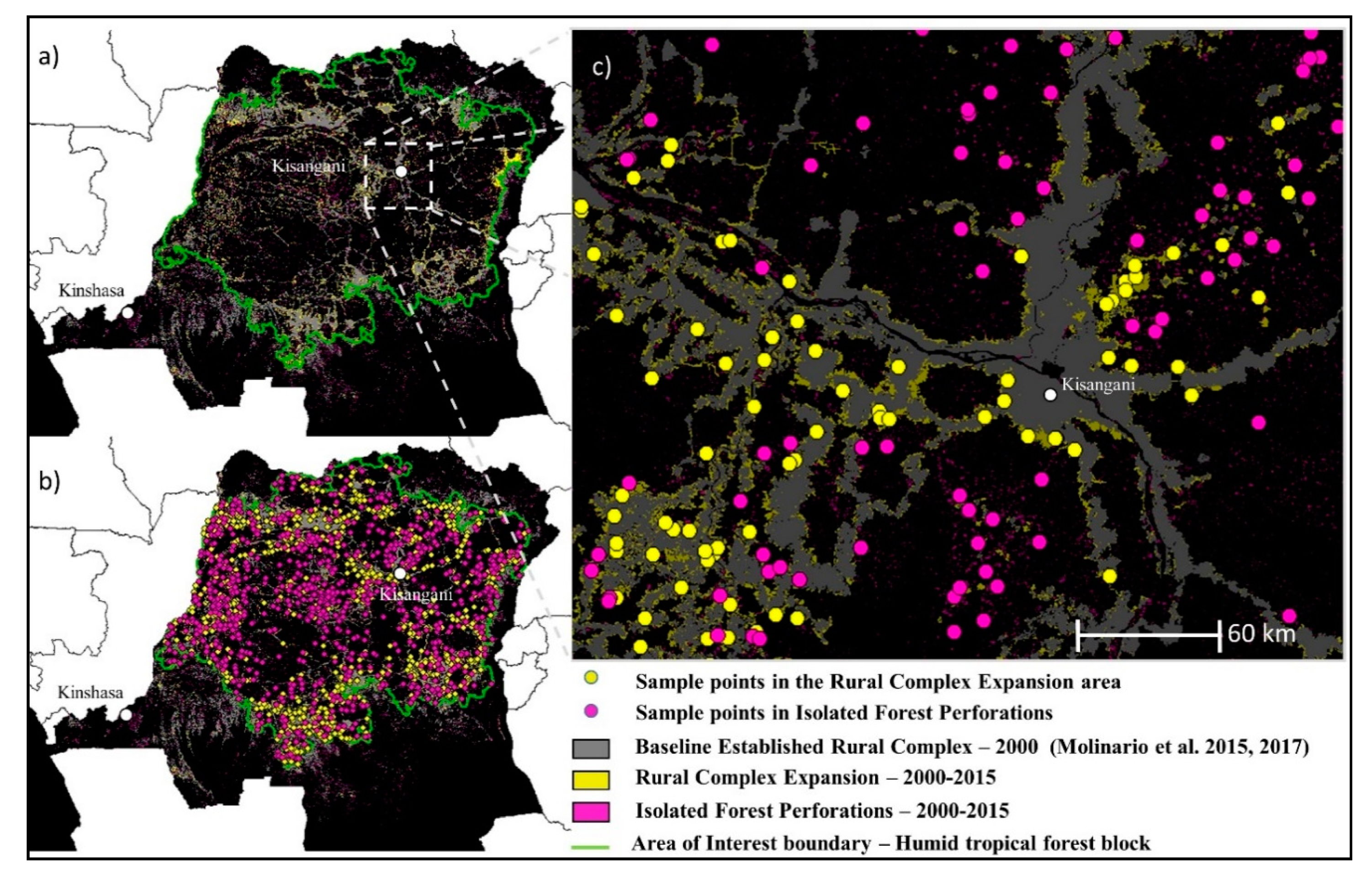
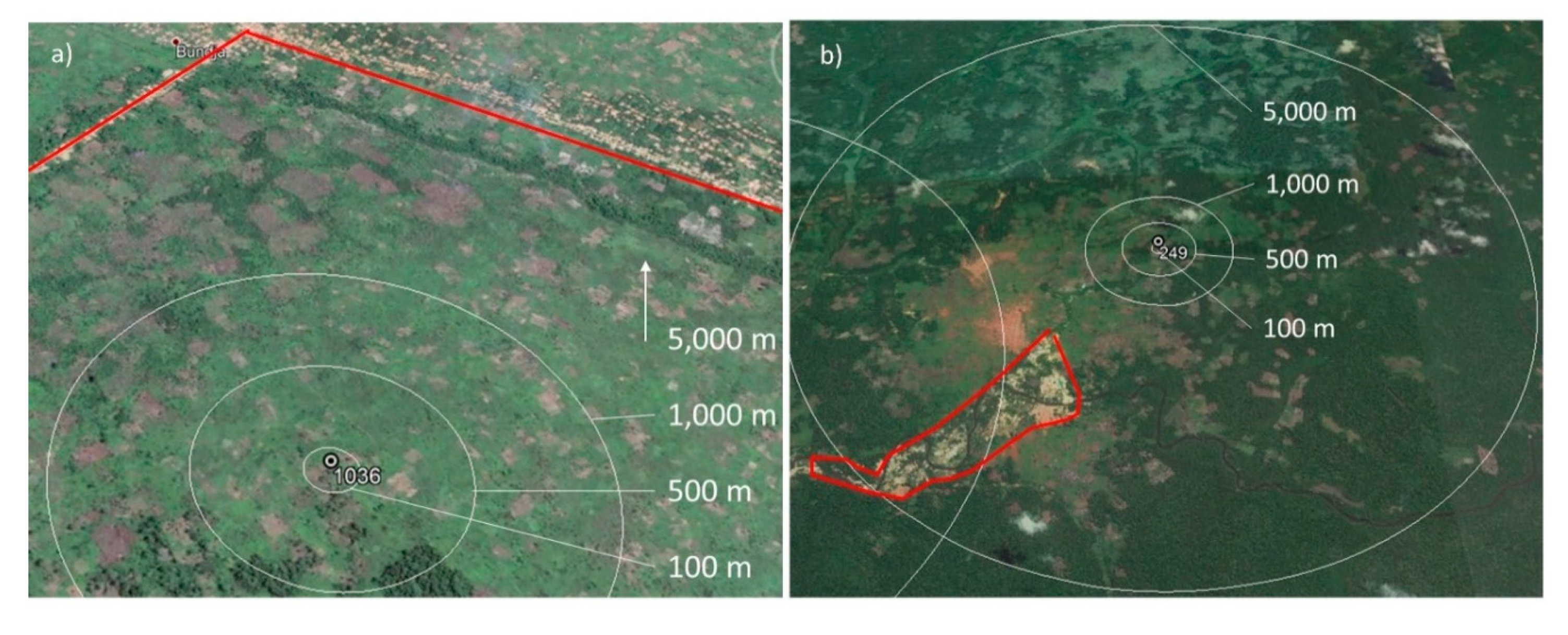
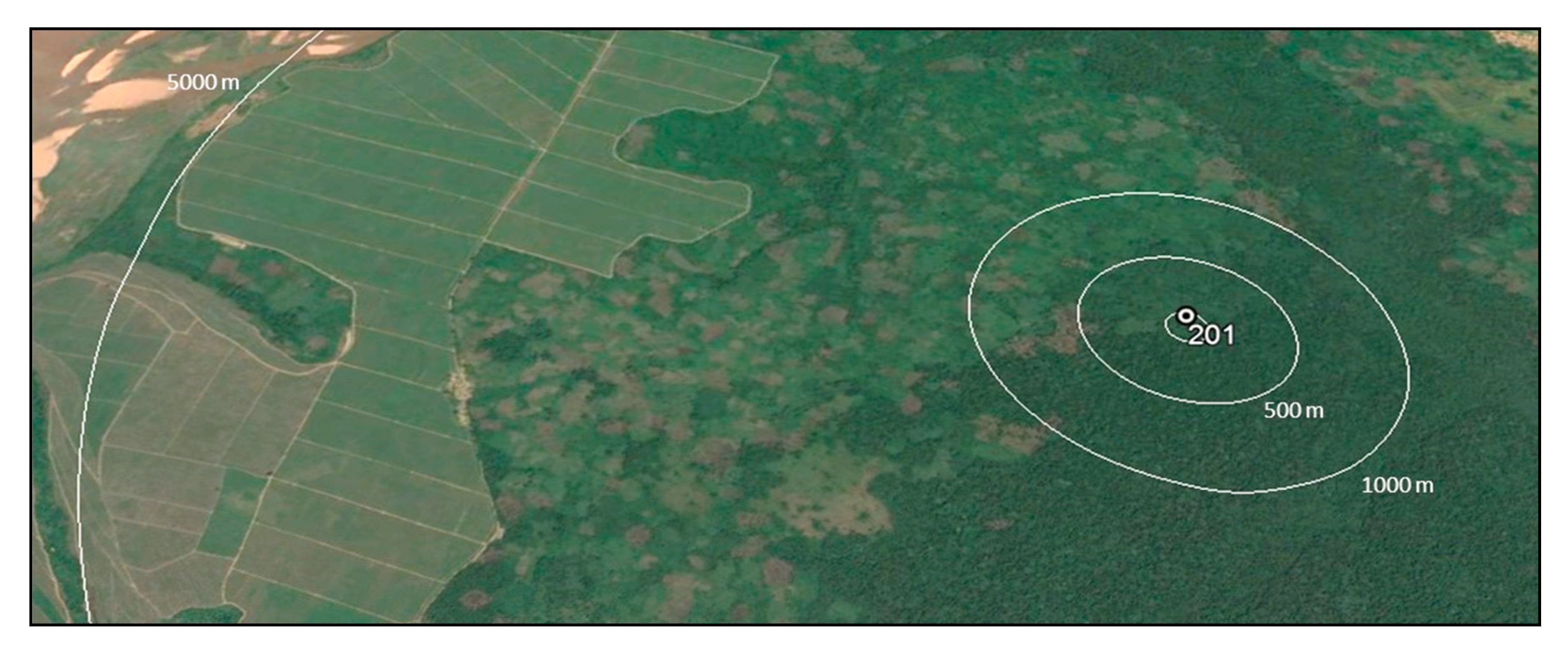
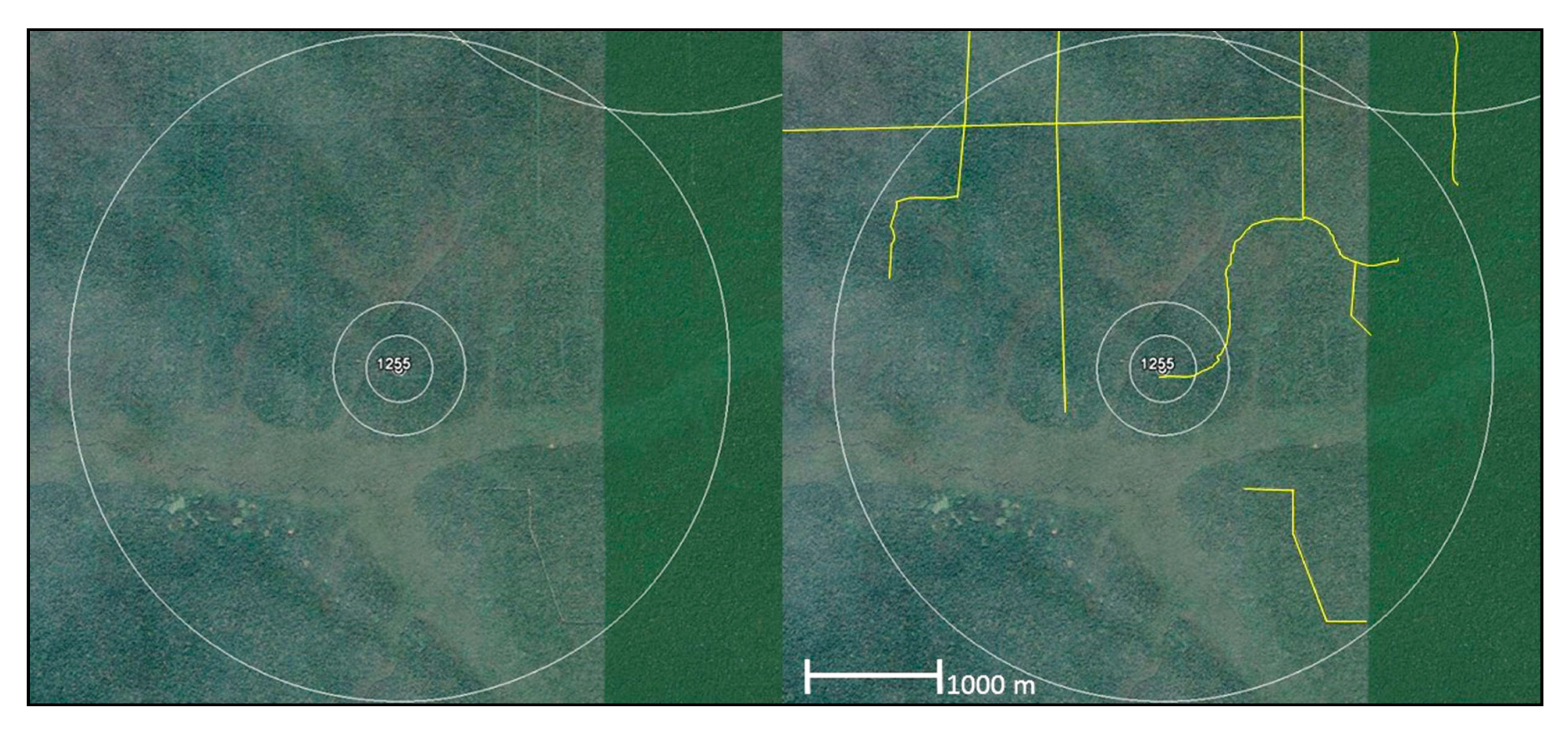
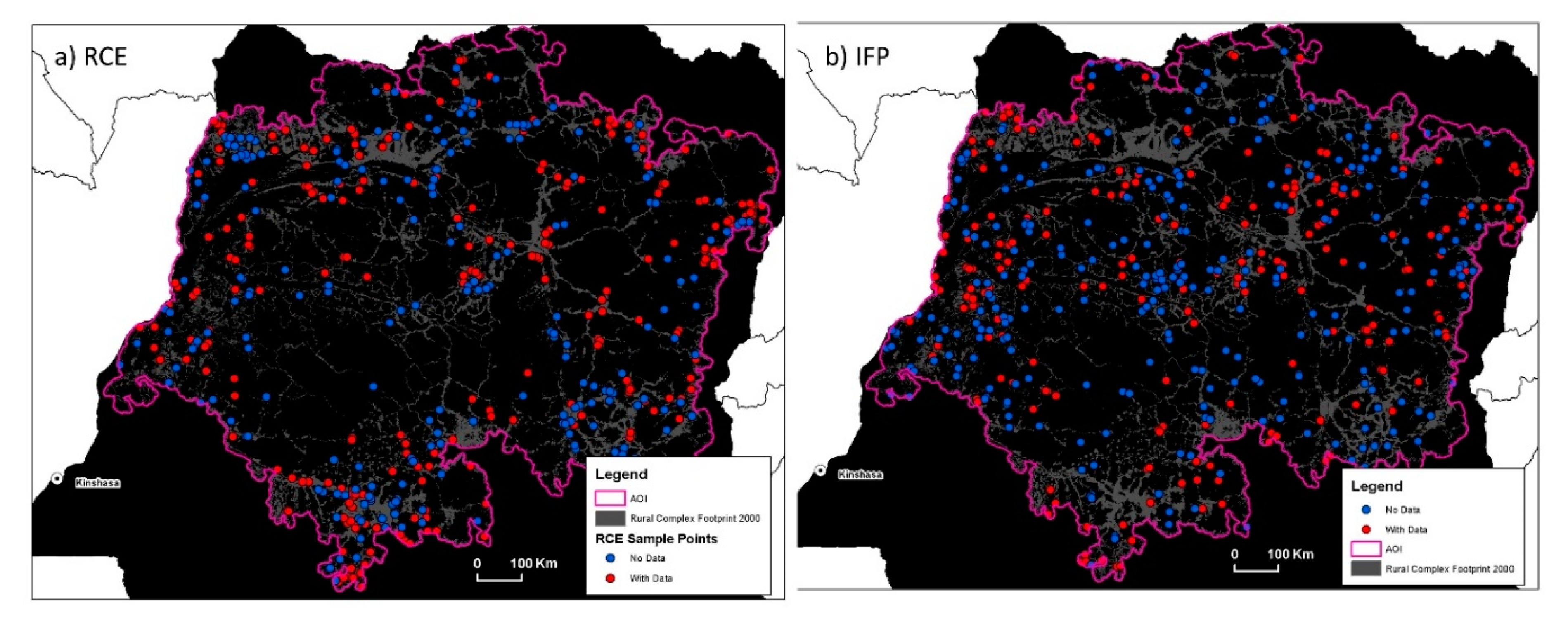
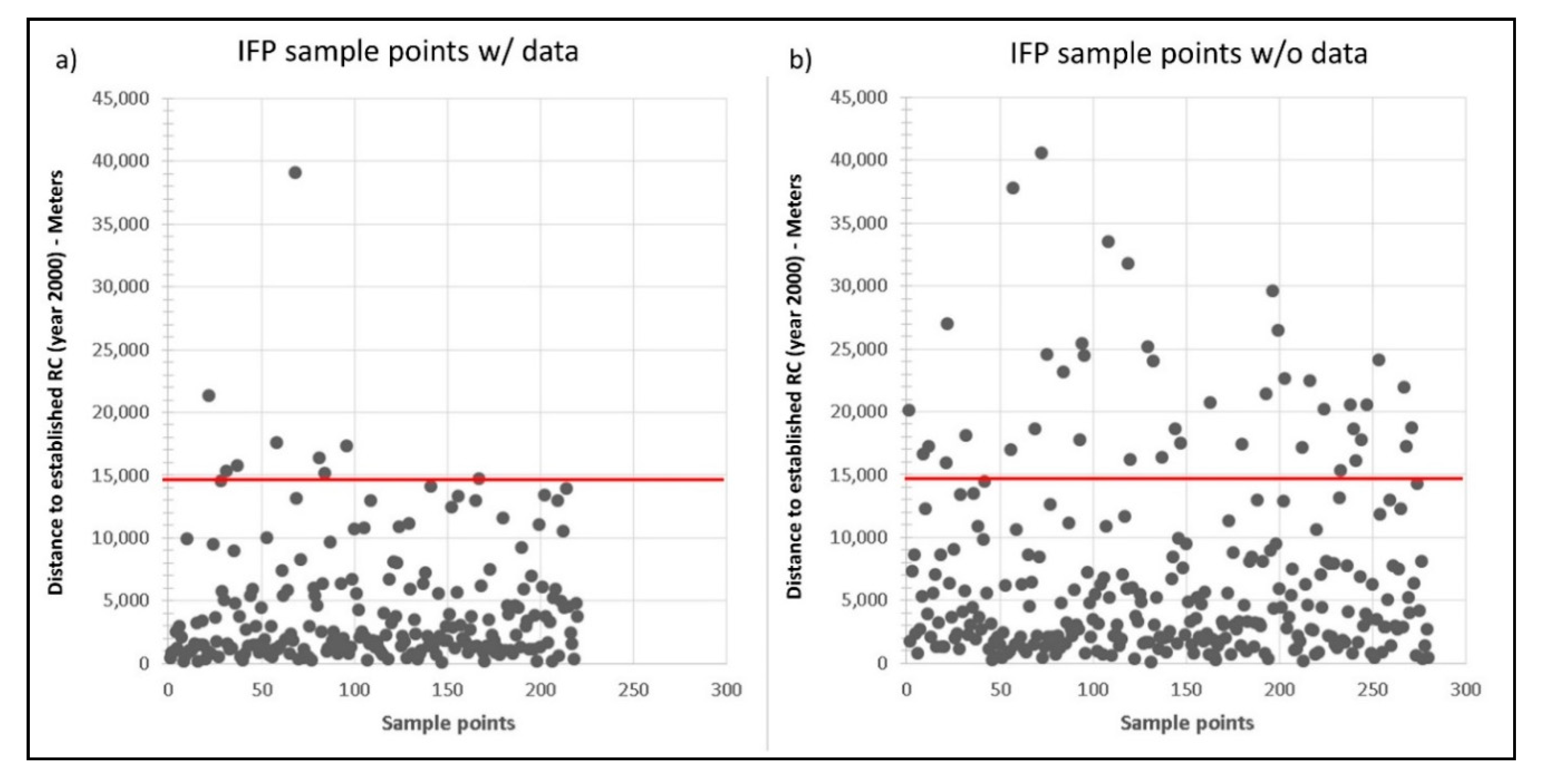
2.2. Sampling Design
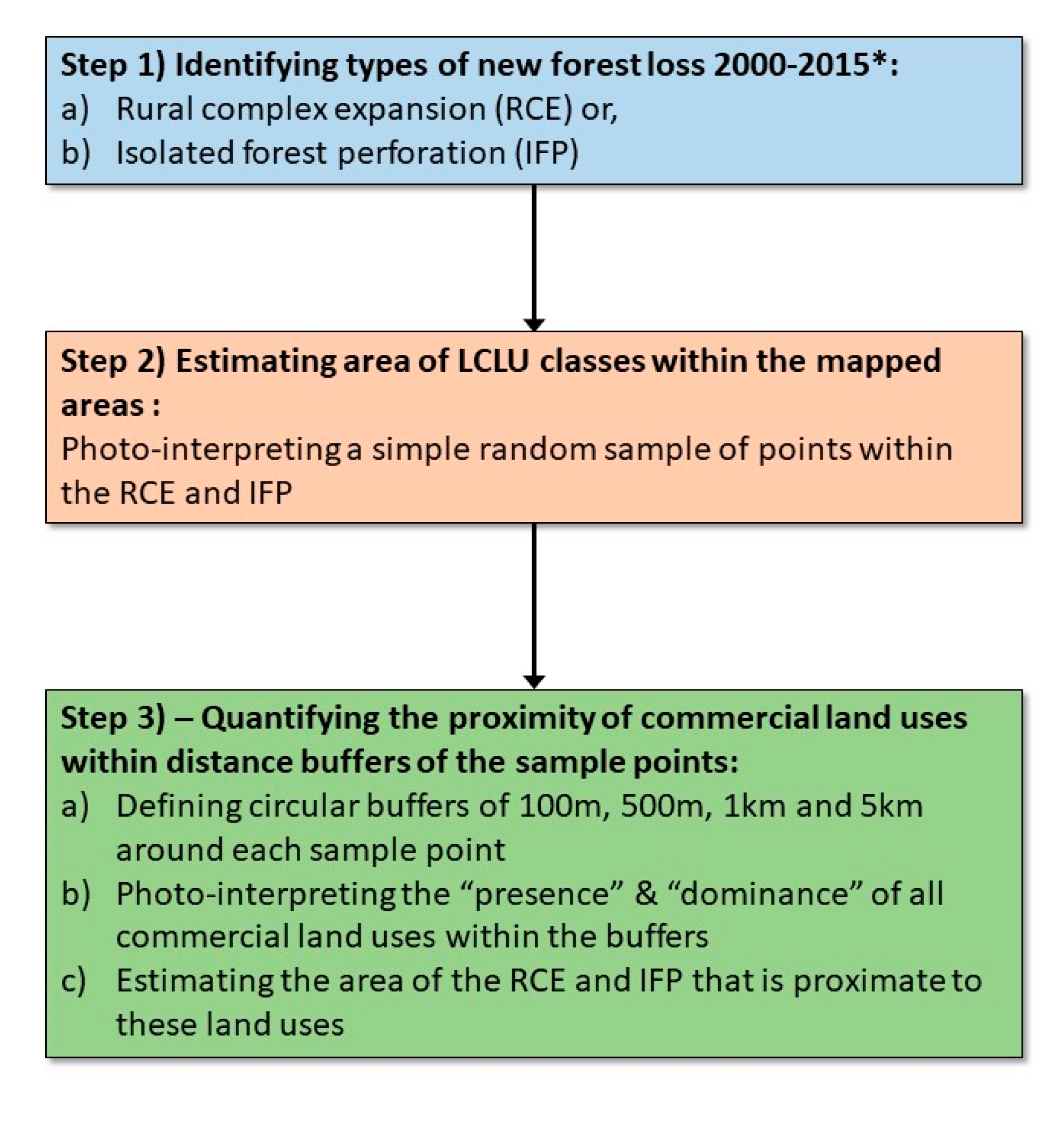
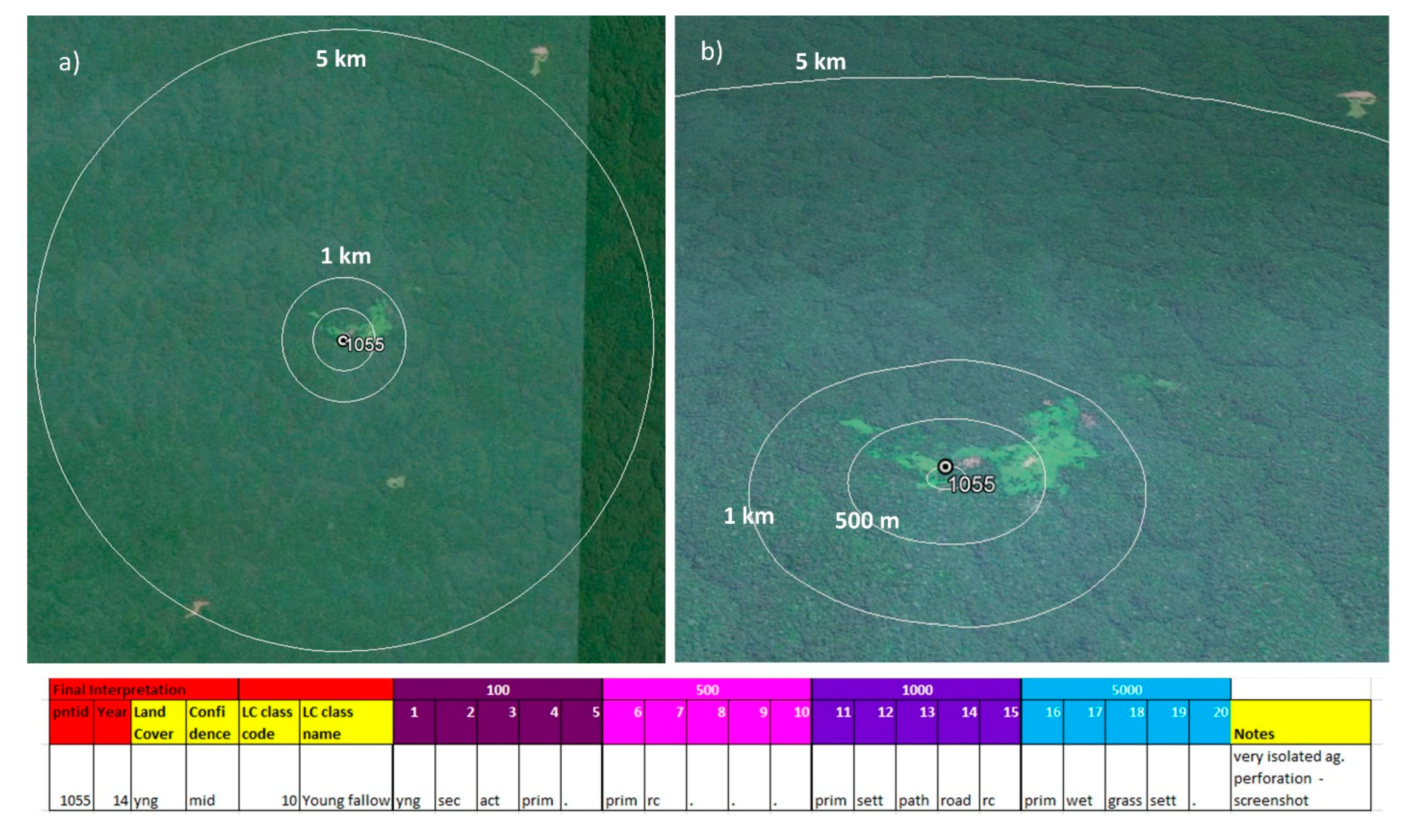
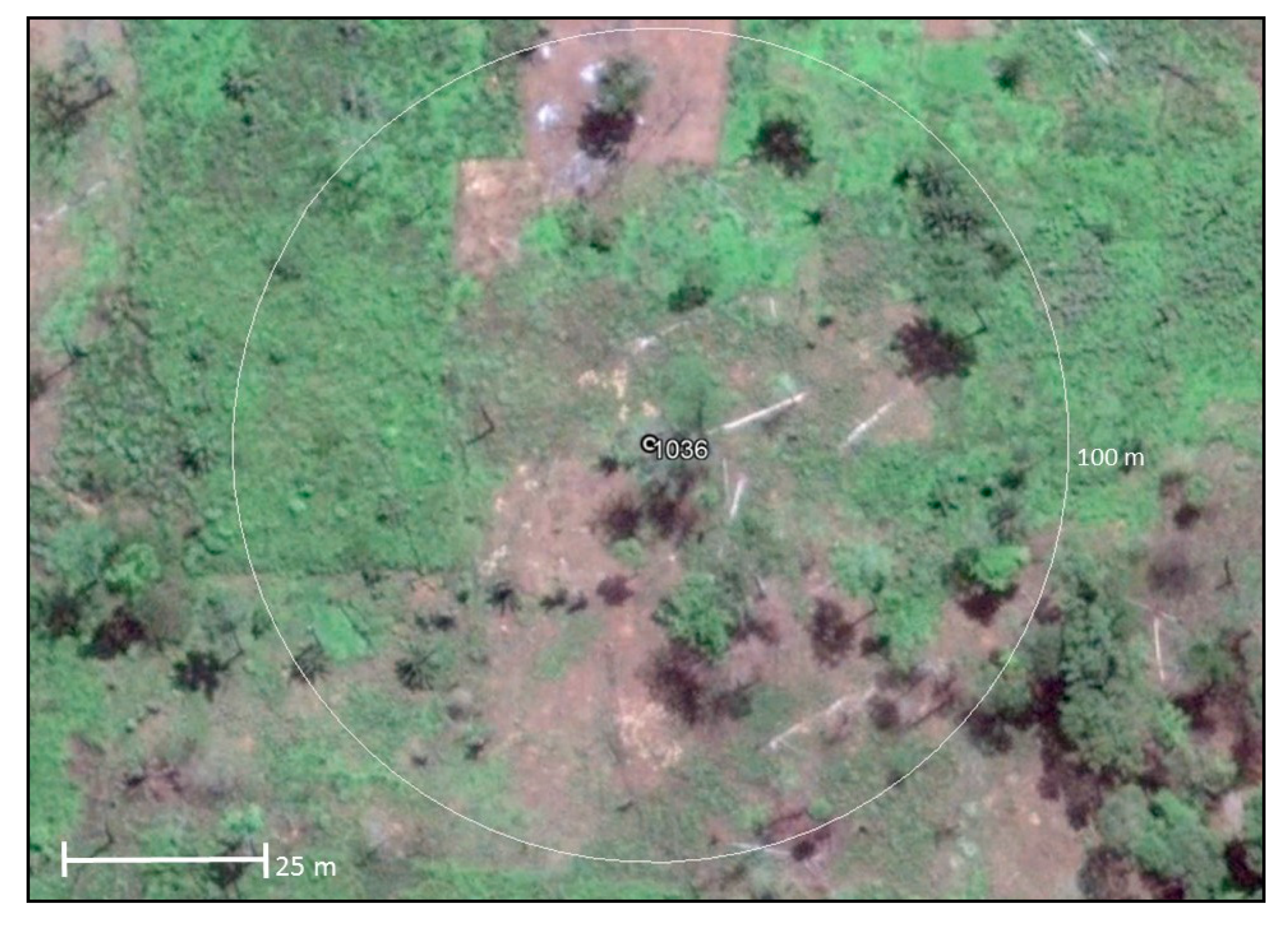
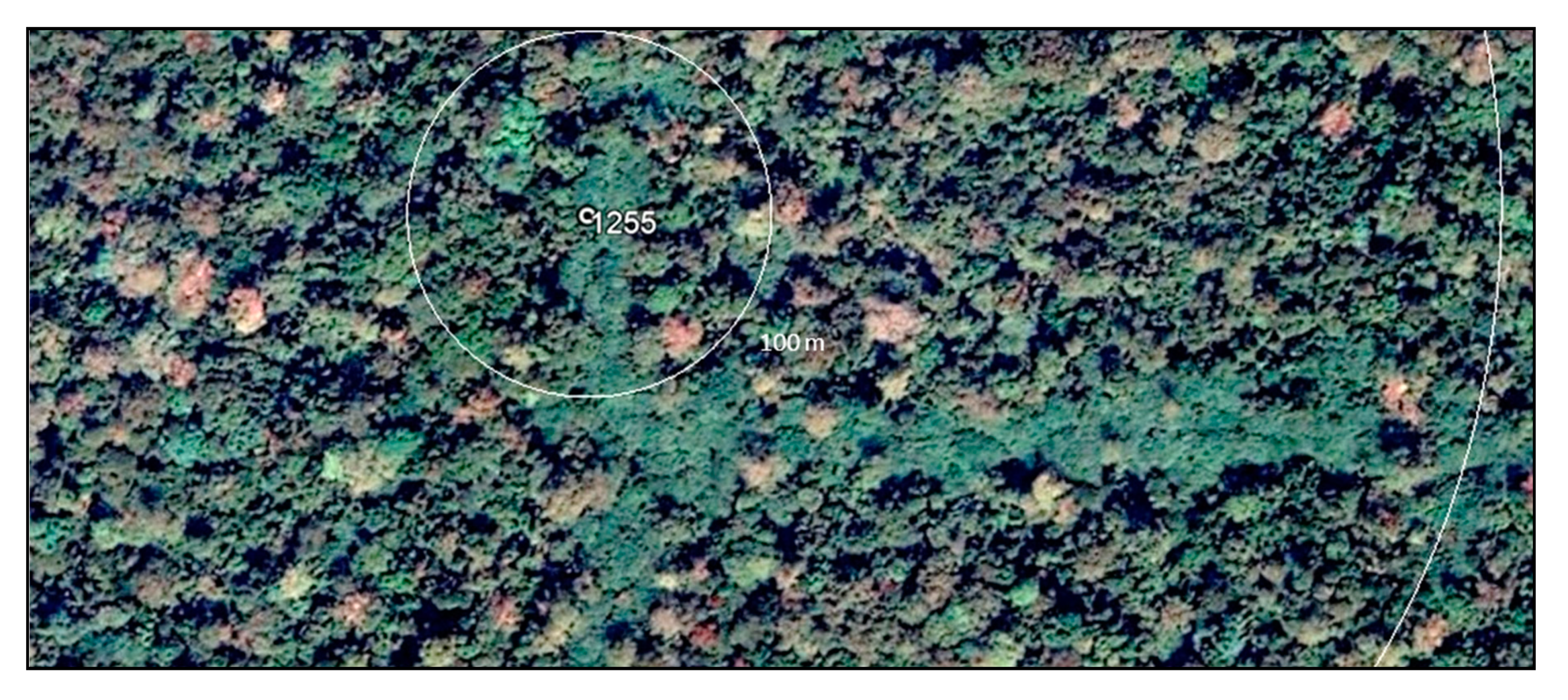
2.3. Image Interpretation Protocol
2.4. Estimating Proportion of Area
3. Results
4. Data Issues
5. Discussion
6. Conclusions
Author Contributions
Acknowledgments
Conflicts of Interest
References
- World Bank World Development Indicators. Available online: http://databank.worldbank.org/data/views/reports/reportwidget.aspx?Report_Name=CountryProfile&Id=b450fd57&tbar=y&dd=y&inf=n&zm=n&country=COD (accessed on 27 June 2018).
- UNDP Human Development Report 2016: Human Development for Everyone. 2017. Available online: http://hdr.undp.org/sites/default/files/2016_human_development_report.pdf (accessed on 27 June 2018).
- World Bank Democratic Republic of Congo Overview. Available online: http://www.worldbank.org/en/country/drc/overview (accessed on 8 October 2017).
- UNOCHA DRC Humanitarian Response Plan: 2018 Update. Available online: https://reliefweb.int/sites/reliefweb.int/files/resources/MAJ_DRC_HRP_2017_En.pdf (accessed on 27 June 2018).
- Kharas, H.; Rogerson, A. Global Development Trends and Challenges: Horizon 2025 Revisited; Overseas Development Institute (ODI): London, UK, 2017; p. 52. Available online: https://www.odi.org/sites/odi.org.uk/files/resource-documents/11873.pdf (accessed on 27 June 2018).
- DeWasseige, C. The Forests of the Congo Basin—Forests and climate change; Weyrich: Neufchâteau, Belgium, 2015; p. 128. [Google Scholar]
- Mayaux, P.; Richards, T.; Janodet, E. A vegetation map of Central Africa derived from satellite imagery. J. Biogeogr. 1999, 26, 353–366. [Google Scholar] [CrossRef]
- Achard, F.; Eva, H.D.; Stibig, H.-J.; Mayaux, P.; Gallego, J.; Richards, T.; Malingreau, J.-P. Determination of Deforestation Rates of the World’s Humid Tropical Forests. Science 2002, 297, 999–1002. [Google Scholar] [CrossRef] [PubMed]
- Ernst, C.; Mayaux, P.; Verhegghen, A.; Bodart, C.; Christophe, M.; Defourny, P. National forest cover change in Congo Basin: Deforestation, reforestation, degradation and regeneration for the years 1990, 2000 and 2005. Glob. Chang. Biol. 2013, 19, 1173–1187. [Google Scholar] [CrossRef]
- Hansen, M.C.; Stehman, S.V.; Potapov, P.V. Quantification of global gross forest cover loss. Proc. Natl. Acad. Sci. USA 2010, 107, 8650–8655. [Google Scholar] [CrossRef]
- Potapov, P.V.; Turubanova, S.A.; Hansen, M.C.; Adusei, B.; Broich, M.; Altstatt, A.; Mane, L.; Justice, C.O. Quantifying forest cover loss in Democratic Republic of the Congo, 2000–2010, with Landsat ETM + data. Remote Sens. Environ. 2012, 122, 106–116. [Google Scholar] [CrossRef]
- Hansen, M.C.; Potapov, P.V.; Moore, R.; Hancher, M.; Turubanova, S.A.; Tyukavina, A.; Thau, D.; Stehman, S.V.; Goetz, S.J.; Loveland, T.R.; et al. High-Resolution Global Maps of 21st-Century Forest Cover Change. Science 2013, 342, 850–853. [Google Scholar] [CrossRef]
- Molinario, G.; Hansen, M.C.; Potapov, P.V. Forest cover dynamics of shifting cultivation in the Democratic Republic of Congo: A remote sensing-based assessment for 2000–2010. Environ. Res. Lett. 2015, 10, 094009. [Google Scholar] [CrossRef]
- Molinario, G.; Hansen, M.C.; Potapov, P.V.; Tyukavina, A.; Stehman, S.; Barker, B.; Humber, M. Quantification of land cover and land use within the rural complex of the Democratic Republic of Congo. Environ. Res. Lett. 2017, 12, 104001. [Google Scholar] [CrossRef]
- Van Vliet, N.; Mertz, O.; Heinimann, A.; Langanke, T.; Pascual, U.; Schmook, B.; Adams, C.; Schmidt-Vogt, D.; Messerli, P.; Leisz, S.; et al. Trends, drivers and impacts of changes in swidden cultivation in tropical forest-agriculture frontiers: A global assessment. Glob. Environ. Chang. 2012, 22, 418–429. [Google Scholar] [CrossRef]
- Maniatis, D.; Mollicone, D. Options for sampling and stratification for national forest inventories to implement REDD+ under the UNFCCC. Carbon Balance Manag. 2010, 5, 9. [Google Scholar] [CrossRef]
- Bucki, M.; Cuypers, D.; Mayaux, P.; Achard, F.; Estreguil, C.; Grassi, G. Assessing REDD+ performance of countries with low monitoring capacities: The matrix approach. Environ. Res. Lett. 2012, 7, 014031. [Google Scholar] [CrossRef]
- Rudel, T.; Roper, J. Regional patterns and historical trends in tropical deforestation, 1976-1990: A qualitative comparative analysis. Ambio 1996, 25, 160–166. [Google Scholar]
- Mather, A.S.; Needle, C.L.; Fairbairn, J. The human drivers of global land cover change: The case of forests. Hydrol. Process. 1998, 12, 1983–1994. [Google Scholar] [CrossRef]
- Geist, H.J.; Lambin, E.F. Proximate Causes and Underlying Driving Forces of Tropical Deforestation. BioScience 2002, 52, 143–150. [Google Scholar] [CrossRef]
- Ickowitz, A. Shifting Cultivation and Deforestation in Tropical Africa: Critical Reflections. Dev. Chang. 2006, 37, 599–626. [Google Scholar] [CrossRef]
- Ickowitz, A.; Slayback, D.; Asanzi, P.; Nasi, R. Agriculoture and Deforestation in the Democratic Republic of Congo: A Synthesis of the Current State of Knowledg; CIFOR: Bogor, Indonesia, 2015. [Google Scholar]
- Pollini, J. Shifting Cultivation, Gender, and REDD+ in Cameroon and the Democratic Republic of the Congo; United States Agency for International Development: Arlington, VA, USA, 2014. [Google Scholar]
- Skole, D.; Tucker, C. Tropical Deforestation and Habitat Fragmentation in the Amazon: Satellite Data from 1978 to 1988. Science 1993, 260, 1905–1910. [Google Scholar] [CrossRef]
- Broadbent, E.N.; Asner, G.P.; Keller, M.; Knapp, D.E.; Oliveira, P.J.C.; Silva, J.N. Forest fragmentation and edge effects from deforestation and selective logging in the Brazilian Amazon. Biol. Conserv. 2008, 141, 1745–1757. [Google Scholar] [CrossRef]
- Luyssaert, S.; Schulze, E.-D.; Börner, A.; Knohl, A.; Hessenmöller, D.; Law, B.E.; Ciais, P.; Grace, J. Old-growth forests as global carbon sinks. Nature 2008, 455, 213–215. [Google Scholar] [CrossRef]
- Balmford, A.; Bruner, A.; Cooper, P.; Costanza, R.; Farber, S.; Green, R.E.; Jenkins, M.; Jefferiss, P.; Jessamy, V.; Madden, J.; et al. Economic Reasons for Conserving Wild Nature. Science 2002, 297, 950–953. [Google Scholar] [CrossRef]
- Potapov, P.; Hansen, M.C.; Laestadius, L.; Turubanova, S.; Yaroshenko, A.; Thies, C.; Smith, W.; Zhuravleva, I.; Komarova, A.; Minnemeyer, S.; et al. The last frontiers of wilderness: Tracking loss of intact forest landscapes from 2000 to 2013. Sci. Adv. 2017, 3, e1600821. [Google Scholar] [CrossRef]
- Mollicone, D.; Achard, F.; Federici, S.; Eva, H.D.; Grassi, G.; Belward, A.; Raes, F.; Seufert, G.; Stibig, H.-J.; Matteucci, G.; et al. An incentive mechanism for reducing emissions from conversion of intact and non-intact forests. Clim. Chang. 2007, 83, 477–493. [Google Scholar] [CrossRef]
- Potapov, P.; Yaroshenko, A.; Turubanova, S.; Dubinin, M.; Laestadius, L.; Thies, C.; Aksenov, D.; Egorov, A.; Yesipova, Y.; Gluskov, I.; et al. Mapping the world’s intact forest landscapes by remote sensing. Ecol. Soc. 2008, 13, 51. [Google Scholar] [CrossRef]
- Southworth, J.; Marsik, M.; Qiu, Y.; Perz, S.; Cumming, G.; Stevens, F.; Rocha, K.; Duchelle, A.; Barnes, G. Roads as Drivers of Change: Trajectories across the Tri-National Frontier in MAP, the Southwestern Amazon. Remote Sens. 2011, 3, 1047–1066. [Google Scholar] [CrossRef]
- Ibisch, P.L.; Hoffmann, M.T.; Kreft, S.; Pe’er, G.; Kati, V.; Biber-Freudenberger, L.; DellaSala, D.A.; Vale, M.M.; Hobson, P.R.; Selva, N. A global map of roadless areas and their conservation status. Science 2016, 354, 1423–1427. [Google Scholar] [CrossRef]
- Damania, R.; Wheeler, D. Road Improvement and Deforestation in the Congo Basin Countries. 2015. Available online: http://documents.worldbank.org/curated/en/762671467986281150/pdf/WPS7274.pdf (accessed on 27 June 2018).
- Nackoney, J.; Molinario, G.; Potapov, P.; Turubanova, S.; Hansen, M.C.; Furuichi, T. Impacts of civil conflict on primary forest habitat in northern Democratic Republic of the Congo, 1990–2010. Biol. Conserv. 2014, 170, 321–328. [Google Scholar] [CrossRef]
- Butsic, V.; Baumann, M.; Shortland, A.; Walker, S.; Kuemmerle, T. Conservation and conflict in the Democratic Republic of Congo: The impacts of warfare, mining, and protected areas on deforestation. Biol. Conserv. 2015, 191, 266–273. [Google Scholar] [CrossRef]
- Lambin, E.F.; Turner, B.L.; Geist, H.J.; Agbola, S.B.; Angelsen, A.; Bruce, J.W.; Coomes, O.T.; Dirzo, R.; Fischer, G.; Folke, C.; et al. The causes of land-use and land-cover change: Moving beyond the myths. Glob. Environ. Chang. 2001, 11, 261–269. [Google Scholar] [CrossRef]
- Rudel, T.K.; Coomes, O.T.; Moran, E.; Achard, F.; Angelsen, A.; Xu, J.; Lambin, E. Forest transitions: Towards a global understanding of land use change. Glob. Environ. Chang. 2005, 15, 23–31. [Google Scholar] [CrossRef]
- Geenen, S. Relations and regulations in local gold trade networks in South Kivu, Democratic Republic of Congo. J. East. Afr. Stud. 2011, 5, 427–446. [Google Scholar] [CrossRef]
- Acker, F.V. Where did all the land go? Enclosure & social struggle in Kivu (D.R.Congo). Rev. Afr. Polit. Econ. 2005, 32, 79–98. [Google Scholar]
- Asner, G.P.; Broadbent, E.N.; Oliveira, P.J.C.; Keller, M.; Knapp, D.E.; Silva, J.N.M. Condition and fate of logged forests in the Brazilian Amazon. Proc. Natl. Acad. Sci. USA 2006, 103, 12947–12950. [Google Scholar] [CrossRef] [PubMed]
- Wilkie, D.S.; Carpenter, J.F. Bushmeat hunting in the Congo Basin: An assessment of impacts and options for mitigation. Biodivers. Conserv. 1999, 8, 927–955. [Google Scholar] [CrossRef]
- Moonen, P.C.J.; Verbist, B.; Schaepherders, J.; Bwama Meyi, M.; Van Rompaey, A.; Muys, B. Actor-based identification of deforestation drivers paves the road to effective REDD+ in DR Congo. Land Use Policy 2016, 58, 123–132. [Google Scholar] [CrossRef]
- Akkermans, T.; Van Rompaey, A.; Van Lipzig, N.; Moonen, P.; Verbist, B. Quantifying successional land cover after clearing of tropical rainforest along forest frontiers in the Congo Basin. Phys. Geogr. 2013, 34, 417–440. [Google Scholar] [CrossRef]
- Tyukavina, A.; Hansen, M.C.; Potapov, P.; Parker, D.; Okpa, C.; Stehman, S.V.; Kommareddy, I.; Turubanova, S. Congo Basin forest loss dominated by increasing smallholder clearing. Sci. Adv. 2018, 4, eaat2993. [Google Scholar] [CrossRef]
- Neigh, C.S.R.; Masek, J.G.; Nickeson, J.E. High-Resolution Satellite Data Open for Government Research. Eos Trans. Am. Geophys. Union 2013, 94, 121–123. [Google Scholar] [CrossRef]
- Miracle, M.P. Agriculture in the Congo Basin. Tradition and change in African Rural Economies; The University of Wisconsin Press: Madison, WI, USA, 1967. [Google Scholar]
- Cochran, W.G. Sampling Techniques, 3rd ed.; John Wiley & Sons: New York, NY, USA, 1977. [Google Scholar]
- Conklin, H.C. The Study of Shifting Cultivation. Curr. Anthropol. 1961, 2, 27–61. [Google Scholar] [CrossRef]
- Service Permanent D’inventaire et d’Amenagement Forestiers (SPIAF) Normes de stratification forestière 2007. Available online: https://www.droitcongolais.info/files/9.11.26.1.-Vade-mecum-de-juillet-2007-pour-l-application-du-code-forestier.pdf (accessed on 27 June 2018).
- Planet Planet to Acquire Terra Bella from Google, Sign Multi-Year Data Contract. Available online: https://www.planet.com/pulse/planet-to-acquire-terra-bella-from-google/ (accessed on 14 February 2017).
- Planet Planet to Launch Record-Breaking 88 Satellites. Available online: https://www.planet.com/pulse/record-breaking-88-satellites/ (accessed on 14 February 2017).
- Finer, M.; Novoa, S.; Weisse, M.J.; Petersen, R.; Mascaro, J.; Souto, T.; Stearns, F.; Martinez, R.G. Combating deforestation: From satellite to intervention. Science 2018, 360, 1303–1305. [Google Scholar] [CrossRef]
- Lesiv, M.; See, L.; Laso Bayas, J.C.; Sturn, T.; Schepaschenko, D.; Karner, M.; Moorthy, I.; McCallum, I.; Fritz, S. Characterizing the Spatial and Temporal Availability of Very High Resolution Satellite Imagery in Google Earth and Microsoft Bing Maps as a Source of Reference Data. Land 2018, 7, 118. [Google Scholar] [CrossRef]
- Bey, A.; Sánchez-Paus Díaz, A.; Maniatis, D.; Marchi, G.; Mollicone, D.; Ricci, S.; Bastin, J.-F.; Moore, R.; Federici, S.; Rezende, M.; et al. Collect Earth: Land Use and Land Cover Assessment through Augmented Visual Interpretation. Remote Sens. 2016, 8, 807. [Google Scholar] [CrossRef]
- Rudel, T.K.; Defries, R.; Asner, G.P.; Laurance, W.F. Changing Drivers of Deforestation and New Opportunities for Conservation. Conserv. Biol. 2009, 23, 1396–1405. [Google Scholar] [CrossRef] [PubMed]
- Pirard, R.; Belna, K. Agriculture and Deforestation: Is REDD+ Rooted In Evidence? For. Policy Econ. 2012, 21, 62–70. [Google Scholar] [CrossRef]
- Carter, M.R.; Little, P.D.; Mogues, T.; Negatu, W. Poverty Traps and Natural Disasters in Ethiopia and Honduras. World Dev. 2007, 35, 835–856. [Google Scholar] [CrossRef]
- Fairhead, J.; Leach, M.; Scoones, I. Green Grabbing: A new appropriation of nature? J. Peasant Stud. 2012, 39, 237–261. [Google Scholar] [CrossRef]
- Megevand, C.; Mosnier, A.; Hourticq, J.; Sanders, K.; Doetinchem, N.; Streck, C. Deforestation Trends in the Congo Basin; Directions in Development-Environment and Sustainable Development; The World Bank: Washington, DC, USA, 2013; ISBN 978-0-8213-9742-8. [Google Scholar]
- Nelleman, C.; Redmond, I.; Refisch, J. The Last Stand of the Gorilla: Environmental Crime and Conflict in the Congo Basin. Available online: https://digital.library.unt.edu/ark:/67531/metadc28506/ (accessed on 2 August 2018).
- De Merode, E.; Smith, K.H.; Homewood, K.; Pettifor, R.; Rowcliffe, M.; Cowlishaw, G. The impact of armed conflict on protected-area efficacy in Central Africa. Biol. Lett. 2007, 3, 299–301. [Google Scholar] [CrossRef]
- Kismul, H.; Hatløy, A.; Andersen, P.; Mapatano, M.; Van den Broeck, J.; Moland, K.M. The social context of severe child malnutrition: A qualitative household case study from a rural area of the Democratic Republic of Congo. Int. J. Equity Health 2015, 14, 47. [Google Scholar] [CrossRef]
- Dupain, J.; Nackoney, J.; Mario Vargas, J.; Johnson, P.J.; Farfán, M.A.; Bofaso, M.; Fa, J.E. Bushmeat characteristics vary with catchment conditions in a Congo market. Biol. Conserv. 2011, 146, 32–40. [Google Scholar] [CrossRef]


| Class Code | Class Name | Description | Potential Confusion: | Observed at What Scale? |
|---|---|---|---|---|
| 1 | No-data | No imagery available with sufficient resolution, or obscuration of the point by clouds, shadows, or bad data | None | All |
| 2, 3, 4 | Water, rivers, ponds | Water, rivers, and ponds | None | All |
| 5, 6, 7 | Roads, paths, settlements | Major roads, paths, and settled areas | None | All |
| 8 | Clearing | Forest or fallow field that has been recently cleared | None | All |
| 9 | Active Agriculture | Field where crops are currently grown | Fallows | 500 m< |
| 10, 11 | Young and old Fallows | Field either recently left fallow or overgrown, with vegetation ranging from grasses and shrubs to large shrubs, young trees, and bamboo | Active ag. | 500 m< |
| 12 | Secondary Forest | Forest stand with over 60% tree cover of trees ≥5 m tall; canopy consists of small, relatively uniform tree crowns, resulting in a bright spectral response | Primary forest | All |
| 13 | Rural Complex | Land cover mosaic of roads, rivers, settlements, clearings, and active agriculture, secondary and primary forest patches. | Grasslands | >100 m |
| 14 | Primary forest | Forest stand with over 60% tree cover of trees ≥5 m tall; canopy consists of highly varying crown size and vertical distribution, resulting in greater canopy shadowing and a dark spectral response | Sec. forest | All |
| 15, 16, 17 | Wetland, gallery and woodland forests | Wetland forest: a stand with over 60% tree cover of trees ≥5 m tall proximate to water bodies & associated floodplains; Gallery forest: were once wetland forest, and remain unaltered as they are wet and low-lying, usually surrounded by derived savanna/grassland or rural complex landscapes. Woodland forest: is sparser, at the edges of the humid tropical forest, interfacing savannas | Primary and sec. forest | All |
| 18 | Grassland | Natural and derived grassland/savanna areas | Active ag. and fallows | All |
| 19 | Croplands | Agriculture that is semi-permanent, with a larger field area and more regular boundaries. They are not usually found in the rural complex mosaic. | Active ag. | All |
| 20 | Commercial Agriculture | Plantation land use associated with crops such as palm oil | None | All |
| 21 | Mines | Clearings and operations that have the appearance of mines: terraces, pits, and ponds clustered together with sometimes worker camps nearby | Clearings | All |
| 22 | Logging | Logging concessions, roads, skid trails. | Clearings | All |
| 23 | Other | Other features that are rare and do not fit in any other class, like natural landslide area, Inselbergs, etc. | n/a | All |
| RCE | IFP | RCE-IFP | |||||||||||
|---|---|---|---|---|---|---|---|---|---|---|---|---|---|
| SE | SE | SE | |||||||||||
| Class Code | Count | % Area | % Area | (km2) | (km2) | Count | % Area | % Area | (km2) | (km2) | % Area | % Area | |
| Primary For. | 14 | 93 | 33.9 | 2.86 | 15,878 | 1338 | 91 | 41.4 | 3.32 | 10,518 | 844 | −7.5 | 4.38 |
| Sec. Forest | 12 | 78 | 28.5 | 2.73 | 13,317 | 1275 | 48 | 21.8 | 2.78 | 5548 | 708 | 6.7 | 3.90 |
| Old Fallow | 11 | 37 | 13.5 | 2.06 | 6317 | 966 | 21 | 9.5 | 1.98 | 2427 | 504 | 4 | 2.86 |
| Clearing | 8 | 24 | 8.8 | 1.71 | 4097 | 799 | 20 | 9.1 | 1.94 | 2312 | 493 | −0.3 | 2.59 |
| Active Ag. | 9 | 21 | 7.7 | 1.61 | 3585 | 752 | 10 | 4.5 | 1.40 | 1156 | 357 | 3.2 | 2.13 |
| Young Fallow | 10 | 16 | 5.8 | 1.42 | 2732 | 663 | 13 | 5.9 | 1.59 | 1503 | 404 | −0.1 | 2.13 |
| Grassland | 18 | 3 | 1.1 | 0.63 | 512 | 294 | 3 | 1.4 | 0.78 | 347 | 199 | −0.3 | 1.00 |
| Road &Settled | 5, 6, 7 | 1 | 0.4 | 0.36 | 171 | 170 | 4 | 1.8 | 0.90 | 462 | 229 | −1.4 | 0.97 |
| Commercial Ag. | 20 | 1 | 0.4 | 0.36 | 171 | 170 | - | - | 0.00 | 0 | 0 | 0.4 | 0.36 |
| Wetland For. | 15 | - | - | 0.00 | - | 0 | 8 | 3.6 | 1.26 | 925 | 321 | −3.6 | 1.26 |
| Woodland For. | 17 | - | - | 0.00 | - | 0 | 1 | 0.5 | 0.45 | 116 | 115 | −0.5 | 0.45 |
| Logging | 22 | - | - | 0.00 | - | 0 | 1 | 0.5 | 0.45 | 116 | 115 | −0.5 | 0.45 |
| Grand Total | 274 | 100% | 46,779 | 170 | 220 | 100% | 25,428 | ||||||
| Class | Code | RCE | IFP | ||||||||
|---|---|---|---|---|---|---|---|---|---|---|---|
| Point | 100 m | 500 m | 1 km | 5 km | Point | 100 m | 500 m | 1 km | 5 km | ||
| All primary forest types | 14, 15, 16, 17 | 33.9 | 45.1 | 70.9 | 78.5 | 73.8 | 45.5 | 54.1 | 87.3 | 87.7 | 87.7 |
| Secondary forest | 12 | 28.5 | 20.4 | 5.5 | 1.1 | - | 21.8 | 15.0 | 0.5 | 0.5 | 0.5 |
| Old fallows | 11 | 13.5 | 10.2 | 0.7 | - | - | 9.5 | 7.7 | - | - | - |
| Clearings | 8 | 8.8 | 8.7 | 2.2 | - | - | 9.1 | 7.3 | 0.5 | 0.5 | - |
| Active fields | 9 | 7.7 | 3.6 | - | - | - | 4.5 | 2.7 | 0.5 | 0.5 | - |
| Young fallows | 10 | 5.8 | 3.6 | - | - | - | 5.9 | 3.6 | - | - | - |
| Grasslands, Savannas, and cropland | 18, 19 | 1.1 | 0.4 | 0.4 | 0.4 | 0.4 | 1.4 | 1.4 | 3.2 | 2.7 | 2.7 |
| Roads, paths, and settlements | 5, 6, 7 | 0.4 | 0.4 | 1.1 | 0.4 | - | 1.8 | 2.3 | 0.5 | - | 0.5 |
| Rural complex (all elements of the RC mosaic) | 13 | - | 7.3 | 18.2 | 18.9 | 23.6 | - | 5.5 | 6.4 | 6.4 | 6.4 |
| Commercial ag. | 20 | 0.4 | 0.2 | 1.4 | 1.8 | 2.4 | 0.4 | 0.2 | 0.4 | 0.6 | |
| Mines | 21 | 0.0 | 0.0 | 1.4 | 2.6 | 0.0 | 0.6 | 1.0 | 1.8 | ||
| Logging | 22 | 0.0 | 0.2 | 0.0 | 1.0 | 0.5 | 0.6 | 0.6 | 0.6 | 1.4 | |
| Total of Commercial land uses | 20, 21, 22 | 0.4 | 0.2 | 1.6 | 3.2 | 6.1 | 0.5 | 1.0 | 1.4 | 2.0 | 3.8 |
| Other | 23 | - | - | - | - | 0.4 | - | - | - | - | |
| Total | |||||||||||
© 2020 by the authors. Licensee MDPI, Basel, Switzerland. This article is an open access article distributed under the terms and conditions of the Creative Commons Attribution (CC BY) license (http://creativecommons.org/licenses/by/4.0/).
Share and Cite
Molinario, G.; Hansen, M.; Potapov, P.; Tyukavina, A.; Stehman, S. Contextualizing Landscape-Scale Forest Cover Loss in the Democratic Republic of Congo (DRC) between 2000 and 2015. Land 2020, 9, 23. https://doi.org/10.3390/land9010023
Molinario G, Hansen M, Potapov P, Tyukavina A, Stehman S. Contextualizing Landscape-Scale Forest Cover Loss in the Democratic Republic of Congo (DRC) between 2000 and 2015. Land. 2020; 9(1):23. https://doi.org/10.3390/land9010023
Chicago/Turabian StyleMolinario, Giuseppe, Matthew Hansen, Peter Potapov, Alexandra Tyukavina, and Stephen Stehman. 2020. "Contextualizing Landscape-Scale Forest Cover Loss in the Democratic Republic of Congo (DRC) between 2000 and 2015" Land 9, no. 1: 23. https://doi.org/10.3390/land9010023
APA StyleMolinario, G., Hansen, M., Potapov, P., Tyukavina, A., & Stehman, S. (2020). Contextualizing Landscape-Scale Forest Cover Loss in the Democratic Republic of Congo (DRC) between 2000 and 2015. Land, 9(1), 23. https://doi.org/10.3390/land9010023