Article

Innovating Along the Continuum of Land Rights Recognition: Meridia’s “Documentation Packages” for Ghana

by
Fuseini Waah Salifu
1,*,
Zaid Abubakari
2 and
Christine Richter
2
1
Ghana Lands Commission, P.O. Box CT 5008, Cantonment, Accra CT5008, Ghana
2
Faculty of Geo-information Science and Earth Observation (ITC), University of Twente, P. O. Box 217, 7500AE Enschede, The Netherlands
*
Author to whom correspondence should be addressed.
Land 2019, 8(12), 189; https://doi.org/10.3390/land8120189
Submission received: 7 November 2019 / Revised: 30 November 2019 / Accepted: 3 December 2019 / Published: 9 December 2019
(This article belongs to the Special Issue Land, Innovation, and Social Good)

Abstract

:
Documentation of land rights can ensure tenure security and facilitate smooth land transactions, but in most countries of the global south this has been difficult to achieve. These difficulties are related to the high transaction cost, long transaction times, and procedural rigidity of land registration processes. In response to these problems, innovative approaches of tenure documentation have been conceived at a global level and are being promoted in many countries of the global south. Little is known yet about how such innovative land tenure documentation approaches unfold in various contexts and to what effect. The implementation of innovative approaches is challenging, due to the legal pluralistic nature of land governance and administrative hybridity in many countries of the global south, including the West African region. This qualitative study explores how Meridia, a small for-profit company, develops innovative approaches to register land rights in the form of “documentation packages” within the existing institutional setting of Ghana. In the paper, we describe both the processes of preparing the documentation packages and respective actors involved, as well as the nature of encounters between innovative interventions and existing institutions. Meridia develops specific products in response to both the regional diversity of land tenure, uses, and market demands, as well as in response to the challenges that the institutional context poses to the process of land tenure registration. As such, the case illustrates how innovation evolves in step-by-step fashion through negotiations with existing land institutions. The various documentation packages developed in this manner differ in terms of cost and complexity of preparation, in terms of recognition by customary and statutory institutions, as well as in the usability of the issued certificates and the extent of exchangeability of associated land parcels. Therefore, Meridia’s product innovation reflects the continuum of land rights, but it also poses questions for future research regarding the political economy of land tenure certification and regarding the actual uses and benefits of issued certificates.

1. Documenting Land Tenure: Old Needs, New Means

According to Lemmen [1], many developing countries have less than 30% cadastral coverage, which implies that more than 70% of land in most countries is not documented in any formal land register. Similarly, a study by Diop [2] indicated that only 10% of rural lands in Africa is registered and the remaining 90% remains undocumented, which makes it vulnerable to land grabbing and expropriation without adequate compensation. The current methods of data capture are too cumbersome, expensive, inaccessible, complicated, and slow, and they are socio-politically problematic, because they tend to exclude marginalized groups from either getting titles to their farmlands or residential plots [3]. In addition, the conventional methods of tenure documentation do not fit the customary systems of land tenure in many places and may create more trouble than good, including the creation of social inequalities and class differences that did not exist before official registration, which in turn may work to the disadvantage of marginalized groups, such as secondary rights holders, women, and youths [4,5].
Given the problems of conventional methods of land documentation [3], new methods, often described as innovative approaches, are being advocated to enable a shift to the adoption of context-oriented tenure documentation [6]. Innovative approaches for land tenure documentation, summarized under the label of fit-for-purpose (FFP), seek to address the above-mentioned problems of conventional methods of land rights documentation. They seek to replace cumbersome surveying technology and techniques with simpler ones that produce faster results, such as mobile-based digital mapping methods, or automatic feature extraction from remote sensing. They also seek to recognize land rights in a continuum as advocated by UN-HABITAT [6]. In the form of scaled-up variants, fit-for-purpose approaches seek to develop land administration systems that are flexible, participatory, inclusive, affordable, reliable, upgradable, and attainable [7,8]. Innovative approaches are being promoted and implemented in various countries around the globe [9,10], but how and in how far they work out in practice has not yet been studied systematically and with little reference to theory. Barry [11], for instance, calls for the identification of critical success factors in the implementation of FFP approaches to “harmonize the activities of different organizations with different cultures and the way each organization is evaluated in a way that addresses the higher level development planning goals”. Many questions invite researchers to contribute both to the evaluation and implementation of tenure documentation and ask the following questions: how do the new approaches for tenure documentation negotiate the existing formal and informal institutions and plural legal frameworks in the course of implementation, how do they bring land tenure documents into official systems of registration, how do they upscale from small-scale projects and initiatives, and how do they affect land governance structures and different groups of people in the longer run?
Specifically, our paper investigates how innovation in land rights documentation actually takes place practically within the plural institutional context of Ghana’s land registration. Ghana’s land registration primarily aims at ensuring legal certainty for property holders, but the processes of registration cut across both customary and statutory institutions. Currently, various initiatives are underway in Ghana to improve the documentation and certainty of property holdings and tenure rights. One of these is the enactment of the new Land Bill with the aim of consolidating all land laws into one for sustainable land administration. Additionally, in order to facilitate access to land registration services, the Lands Commission under the Land Administration Project (LAP) initiated the establishment of Customary Land Secretariats (CLSs) as an administrative interface for customary authorities and also is in the process of establishing the Client Service Access Units (CSAU) at the regional Lands Commission offices. There are other initiatives being implemented by different organizations in collaboration with statutory actors, customary actors, as well as the communities, whose land rights are being documented. One of these initiatives is promoted by Meridia, a small for-profit organization that has been referred to as an innovative approach to land tenure documentation by Lengoiboni et al [9]. On the basis of fieldwork in Ghana by the first author, our study takes a closer look at the nature of innovation in the case of Meridia and the encounters that ensue between Meridia and the existing customary and statutory institutions during the process of land rights registration as well as the intermediate and longer term outcomes of Meridia’s intervention.
After sketching out the land administration scene in Ghana in the following sections, section three describes the methods of data collection and analysis. In section four, we describe the preparation of four documentation packages by Meridia and the kind of challenges that are encountered, due to existing institutional practices and requirements and the contextual dynamics of land tenure and livelihoods. In section five, we discuss the processes as a case of product innovation and reflect on the longer term outcomes of the documentation in terms of recognition and usability of the issued certificates before pointing out future research directions as a conclusion.

2. Ghana’s Institutional Framework for Land Administration

Land administration in Ghana is hybrid in nature, cutting across the spectrum of customary and statutory institutions and within the statutory institution, the hybridity cuts across the forms of land registration, title, and deed. The hybridity within the institutions (i.e. the customary and statutory) emerges from the evolved land tenure patterns in Ghana [12,13]. In precolonial Gold Coast (modern day Ghana), customary institutions had control over all land [14,15], but the situation changed during the colonial regime when some land was annexed by the colonial administration for administrative purposes [16]. Following independence and post-independence nation building, the government still acquires land for public purposes. Through these colonial and post-independence developments, two regimes of tenure in Ghana are dominant, customary and state tenure. While customary institutions still hold and control about 80% of land in Ghana [17,18], less than 20% is state land. Article 267(1) of the 1992 Republican Constitution of Ghana mandates that all stool1 lands in Ghana shall vest in the rightful stool on behalf of, and in trust for the subjects of the stool by customary law and usage. This constitutional provision justifies the role of customary institutions in land administration. Article 258 of the 1992 Republican Constitution establishes the Lands Commission as a statutory body to manage state and vested lands. Besides the Lands Commission, there were other land sector agencies that participated in the land registration process namely, the Land Valuation Board, Survey Department and Land Title Registry. Being statutory agencies, the duties of these agencies are defined. However, the role of customary institutions in land administration was not explicit as per the constitutional provision in Article 267(1), so their involvement in formal land administration was not well streamlined until 2003 when the Ghana Land Administration Project (LAP) made institutional reforms in land administration and established the Customary Land Secretariats (CLSs) to serve as an interface that connects activities of the customary institutions to that of the Lands Commission [19]. The LAP also facilitated the enactment of the Lands Commission Act (Act 767,2008 which turned the four independent land sector agencies into divisions under the new Lands Commission. Currently, land title registration (established by the Land Title Registration Law of 1986) takes place in only the Greater Accra and Ashanti regions of Ghana while the other regions still practice deed registration (established by the Land Registry Act of 1962). The long term plan is to replace the deed registration with title registration.
Current methods of spatial data acquisition in Ghana are field based as required by sections 16 and 17 of the Survey Act, Act 127, 1962 and section 7 (1–2) of the Land Title Regulation 1986 (LI 1341). These regulations require that a permanent beacon (monument) should separate boundaries between two parcels and be maintained in a manner determined by the Director of the Surveys. Connected to the monuments is the rigid observation time for mapping. The Lands Commission has specific required observation times for different land uses. For example after getting a vantage point to pick the coordinates of a boundary, one still has to wait for three minutes for farmlands and 15 minu for residential properties. Although the land registration laws provide for the registration of diverse land rights, only leaseholds are mostly registered by the Lands Commission due to limitations in administrative capacity, multiple interpretations of land laws and the influences of multiple normative frames [12,13].

3. Materials and Methods

3.1. Description of the Study Area

The study was conducted in two regions of Ghana, namely, the Greater Accra Region with Accra as its capital and the Western region of Ghana with Wassa Akropong as the chosen community (see Figure 1). Accra was chosen because most of the national offices are located here, because Accra is the seat of the Government. Meridia’s headquarters and the Head Office of the Lands Commission are also located in Accra. The Wassa Akropong farming community was selected as one of the areas where Meridia has implemented their initiatives.
Wassa Akropong is a town located in the western region of Ghana, and it is the capital town of Wassa Amenfi East District. According to the 2010 national population census, the town has a current population of 7094. Agriculture is the most dominant economic activity in the area and accounts for about 66 percent of the total population. The Wassa Amenfi East District, where Wassa Akropong is the capital town, is engaged predominantly in cocoa farming and contributes significantly to the overall cocoa production in the country.

3.2. Sampling and Methods of Data Collection

The study employed a non-probability sampling technique dominant in qualitative research, namely purposive sampling and specifically snowballing techniques to obtain primary data for the study using semi-structured interviews and focus group discussions (from October to November, 2017). In purposive sampling units are selected due to their knowledge about and experience with the research topic or case, in direct reference to the research question [20]. To understand the statutory and administrative requirements of land surveying and registration, we interviewed four officials of the Lands Commission. Furthermore, to understand Meridia’s operations in land documentation, we interviewed five officials with different ranks and roles within Meridia. To briefly sketch out Meridia’s general motivations and approach we draw on an additional interview conducted with Meridia (then called Landmapp) in March 2017 by the third author. Since the processes of land registration in the study areas cut across both statutory and customary institutions, we also interviewed five chiefs and the coordinator of one Customary Land Secretariat to find out the roles they play in land registration and how they deal with Meridia in the registration process. We used purposive sampling to select respondents from the Lands Commission, Meridia, Traditional authorities, and the Customary Land secretariat. The respondents interviewed hold adequate experiences and insight through their long services in their operational institutions. We also organized three focus group discussions with 13 respondents at Wassa Akropong Community, where Meridia implemented their initiative. The participants of the focus group discussions were farmers who had land certificates from Meridia or were in the process of obtaining land certificates. The 13 participants included 5 males who formed one focus group discussion, whilst the 8 females were divided into two separate groups for two focus group discussions consisting of 4 members each. In total, three separate focus group discussions were held at Wassa Akropong to learn about their experiences concerning the implementation of the Meridia initiative. Table 1 below shows the number of people sampled for the purposes of this study and the corresponding data collection methods.
Aside from the primary data, we also used secondary data which includes the technical instruction of surveyors collected from the Survey and Mapping Division of the Lands Commission. The technical instruction of surveyors contains comprehensive instructions that guide how survey work should be carried out in Ghana.

3.3. Data Analysis and Interpretation

Our analysis consisted of three stages. First, on the basis of the responses from the interviews and focus group discussions, we used process mapping, specifically flowcharting [21], to describe in detail the processes of preparing four so-called documentation packages, which Meridia has designed (see Section 4.1). Then, through thematic analysis [22], the responses obtained from interviews and focus group discussions were sorted into three types of encounters that ensued between Meridia’s interventions and the existing institutional arrangements during the processes of registration (see Section 4.2). Finally, we took the analysis to a more interpretive level in Section 5 of the paper. Here, we discuss the nature of Meridia’s product innovation and position the certificates issued along three conceptual dimensions of benefit: level of cost/complexity of the registration process, degree of recognition of the certificates, and level of usability of the certificates along with the land parcel’s potential exchangeability (see Section 5).
In our study internal validity is established through triangulation. We gathered data from multiple sources, established a sequence of evidence, and analyzed the data across various respondent categories (see Table 1). In the process, data sourced from the different interviewees were cross-checked with others for convergences and divergences. We also used the technical instruction of surveyors to cross-verify the interviews held with the statutory actors as well as the implementers of innovative approaches regarding formal requirements for land surveying. In addition, the first and second authors’ experiences of working in Ghana’s land administration sector for several years contributed to the internal validity, as this contextual knowledge helped to increase the “level of congruence between concepts and observations” [20] (p. 390). Furthermore, a first draft of this paper was shared with representatives of Meridia for respondent validation [20]; and to ensure the dependability of the study [20], complete records were kept of all phases of the research by means of a data management plan.

4. Results: Meridia’s Innovations and Encounters with Land Governance Institutions

This section describes Meridia’s innovative approaches to register land. Meridia’s initiatives in land tenure documentation take the forms of product and institutional innovations, by which Meridia seeks to meet the needs of landholders and at the same time reasonably negotiate institutional challenges. To achieve the product and institutional innovation, Meridia, among other things, makes use of technological solutions which are embedded in the innovations. Following the first two stages of analysis described above, Section 4.1 below describes the documentation packages designed by Meridia to meet the needs of different categories of landholders and how each requires different processes of registration. Then, Section 4.2. describes the encounters between the existing institutions and the changes sought by Meridia.

4.1. Meridia’s General Motivations and Approach

Under its previous name Landmapp, Meridia followed up on land tenure documentation activities by Thomson Reuters in Ghana, a country with an active NGO and consultancy scene and ongoing national and internationally led initiatives to develop land tenure documentation processes. Meridia initially focused on farmers’ land tenure security, especially of small holder and cocoa farmers; as the founders of Meridia see farmers as stewards of the environment. The organization later expanded its documentation activities to urban areas. Developing a business model is ongoing, because the process of documentation is influenced by the fees that need to be paid to customary and statutory authorities for signatures and approvals. These fees are not standardized and can vary by region or time. The costs for the training of local mappers and quality checks of the produced data also vary. Besides these variances, the basic premise for the long-term is to be financially self-sustaining and eventually profit-making through the sale of land tenure documentation services to land holders. A customer base is developed step by step following demand pulls. In order to identify this demand and enroll communities into the documentation endeavor, Meridia puts a lot of effort into understanding the socio-economic and political conditions across different regions in Ghana and the local team working on implementation consists of Ghanaian nationals. During initial visits, farmers’ willingness to pay for land tenure documents is explored and sometimes down payments are made to indicate commitment to the process. In some cases, several visits are made to communities to gain trust; and before the actual documentation process starts, training and sensitization programs are conducted. In some cases customary authorities, for instances, chiefs have requested for the documentation of specific areas.

4.2. Product Innovation by Meridia: Adjusting the Land Registration Process to Market Demands

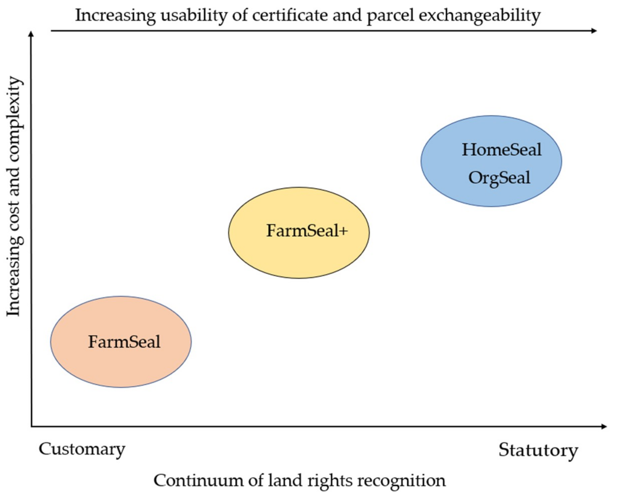
Land registration in Ghana typically results in the registration of leaseholds. With this unified form of registration, all categories of landholders, irrespective of location and land use, are required to follow the same process of registration in order to have their holdings recorded. To provide more context-oriented land tenure documentation, Meridia designed a continuum of so-called “documentation packages” through a combination of technological and institutional innovations. These different products provide landholders with the opportunity to engage in different forms of registration ranging from the acknowledgement of customary arrangements to the full registration of a leasehold. Meridia’s documentation packages are, in the first instance, designed around different types of land uses. The packages are the FarmSeal, FarmSeal+, HomeSeal, and OrgSeal. The FarmSeal and the FarmSeal+ are more tailored for rural areas where agriculture is the predominant land use with low levels of income among peasant farmers. Given the relatively low costs involved in documenting FarmSeal and FarmSeal+, more peasant farmers are able to have their land rights recorded in some way with possibilities of scaling up to a full leasehold title at a later time. The HomeSeal and the OrgSeal are designed for urban areas which are more cosmopolitan and with relatively higher property values. In these contexts, a higher level of legitimation is often required to validate ownership and transfer, which calls for additional steps at the Lands Commission for official registration. Although in some instances the packages can be adapted according to particular community’s or landholders’ needs across the urban/rural differentiation, we describe the operations of Meridia in the following first for rural, then for urban areas.

4.2.1. Meridia’s Operation in Rural Areas: The Preparation of FarmSeal and FarmSeal+

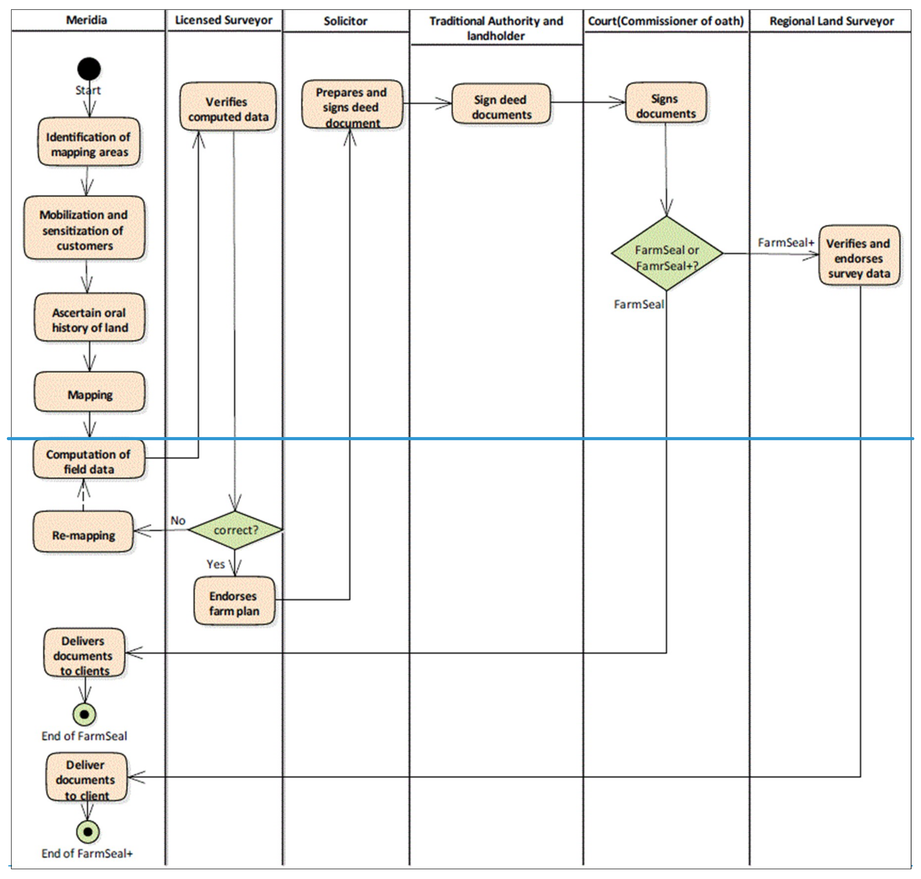
The steps of Meridia’s land tenure documentation process begins with the identification of suitable areas for tenure documentation by Meridia, where Meridia tries to follow demand pulls rather than supply push. Their concept of tenure documentation was first proven in areas with at least some commercial farming, because these farmers can pay for the services. After identifying areas to document, Meridia conducts so called “sensitization activities” with the communities. Meridia informs the community about a date and time to meet for sensitization activities. The sensitization team goes to the community for at least one week to educate the community about the importance of tenure documentation before the actual mapping of land boundaries and rights takes place. After the sensitization is conducted, Meridia interviewers go to farmers’ houses to interview them as well as the neighbors to ascertain the oral history of their lands. The initial interview is held with the holder of the land and the grantor and sometimes people from the community. The interviewers obtain some background information concerning how the farmer acquired the land, witnesses that were present during the time of acquisition of the land, and the number of years the farmer had to stay on the land. Later the Meridia mappers also ask the farmers the same questions asked by Meridia interviewers as a means of cross-validation of the information. After the ascertainment of the oral history of the land, the Meridia mappers go to the field with their equipment to carry out the survey. During the survey, the farmers together with a neighbor lead the whole process of defining the boundaries of the farm. They walk around the boundary while the mapper picks the boundary points with GPS. The neighbors are involved in the survey to testify that boundaries, which have been surveyed, are correct and belong to the said owner. The farmers also help in putting the PVC plastic pipes at the place where the coordinates were picked, and concrete is poured into the hole of the PVC pipes to serve as a monument. The farmers also help in the clearing of the boundaries of the farmlands to make it easier for movement during mapping. After the mappers have conducted their mapping, they upload the data into the Meridia integrated end-to-end information system (database linked to mobile application). The Geographic Information Systems (GIS) team in Accra then have access to the data to do computations as well as to eliminate errors and anomalies from the gathered data to produce a farm plan. After the computation is done, the GIS team submits the farm plan and the data to the licensed surveyor for verification and validation. The validated farm plan and deed document are prepared and endorsed by a solicitor and subsequently signed by the traditional authorities (paramount chiefs) and the landholder which are then endorsed by the commissioner of oath at the high court. This marks the end of the documentation for a FarmSeal. For FarmSeal+, the certified farm plan is taken further and submitted to the Regional Lands Surveyor of the Lands Commission for approval. Finally, Meridia sets a date to go to the community to deliver the signed documents. The processes for preparing FarmSeal and FarmSeal+ are shown in Figure 2 below.
The process description above shows that the preparation of the FarmSeal and the FarmSeal+ involves both customary and statutory actors. The chiefs and the commissioner of oath endorse the documents to give it legal backing as well as satisfying land registration requirements set forth by the Lands Commission. The FarmSeal+ constitutes a move into the direction of stronger formal recognition beyond the customary institutional realm in that it also involves approval by the Regional Land Surveyor and certification by the licensed land surveyor as a statutory requirement for further registration with the Lands Commission.

4.2.2. Meridia’s Operation in Urban Areas: The Preparation of HomeSeal and OrgSeal

For urban areas, two other documentation packages were designed by Meridia, namely the HomeSeal and the OrgSeal. The HomeSeal itself consists of residential and commercial seals. It is designed to meet the specific conditions of urban areas. It provides home owners and commercial property owners with a certified and approved site plan with a fully signed deed document with an option to continue forward to deed or title registration at the Lands Commission, depending on the client’s request. The OrgSeal is similar in this respect, because it may lead to full title registration upon the client’s request. While the HomeSeal is for holders of individual land parcels, the OrgSeal is designed for organizations that have large parcels of land and buildings. With the OrgSeal, all parcels and buildings belonging to one organization across the country are mapped and included in an online inventory and processed for title registration.
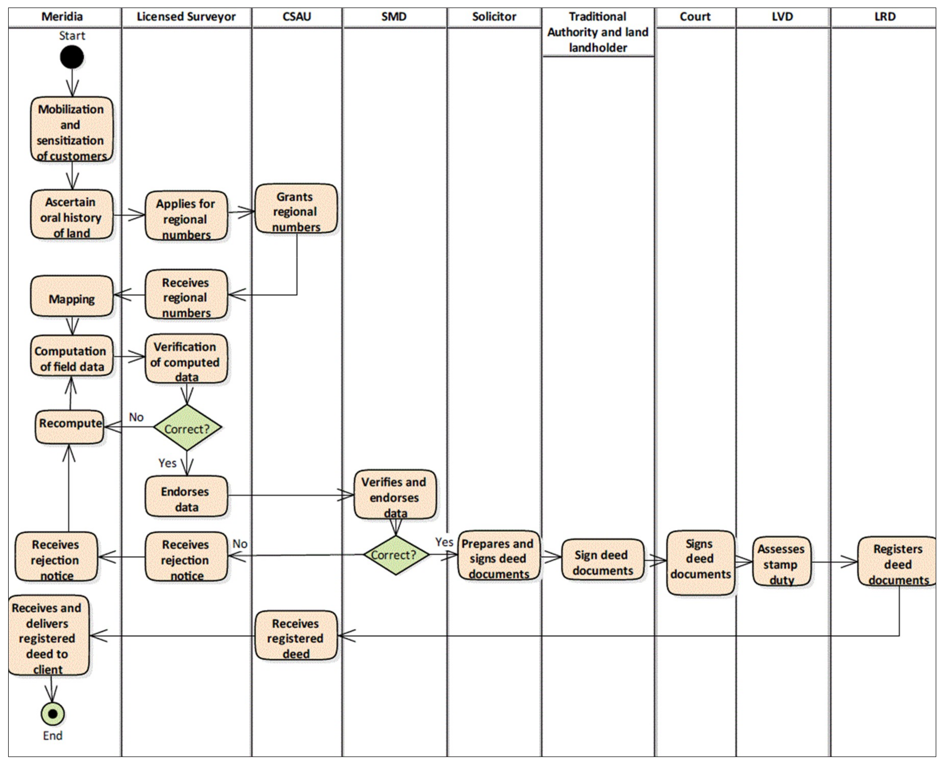
The documentation process for both the HomeSeal and OrgSeal begins with areas which have already been well planned by the Town and Country Planning Department, the agency responsible for spatial planning. The next step after the preparation of planning schemes is the mobilization and sensitization of potential customers as well as the ascertainment of the oral history of the land in the same manner as described for the FarmSeal and FarmSeal+. After the ascertainment of the oral history of the land, the licensed surveyor applies to the Client Service Access Unit (CSAU) of the Lands Commission for the issuance of regional numbers. These numbers are necessary to identify the survey work to be carried out in that year and area.They are prerequisites needed by surveyors before going to the field. The regional numbers are generated and given to the licensed Surveyor subject to the payment of a fee. After obtaining the regional numbers from the CSAU and related datasets by the licensed surveyor, Meridia’s mappers go to the ground to carry out the survey work according to the technical instructions of the surveyors and other relevant laws of the country. The regional numbers are planted on the ground to be able to generate monument numbers for each corner. There are different types of monuments: type A, B, or C, depending on the kind of survey to be conducted. The Meridia mappers usually carry out the mapping using emlid reach GPS devices together with the landowners and neighbors, who help to define the boundaries of the land. After the survey work, the mappers send the data through the Meridia end-to-end integrated information system (database linked to mobile application), which are processed and certified by the licensed surveyor. After the certification of the documents by the licensed surveyor, the documents are submitted to the CSAU of the Lands Commission by the licensed surveyor. The submitted file contains the following: field report or history of the survey, letter of submission, Ex Data (the control points the Licensed Surveyors took from survey and mapping Division), raw field data (rinex format), and point list. The submitted file should also contain the beacon index, computation of bearing and distance, plan data, area computation, a diagram of the survey, total survey record on CD, eight copies of the certified plan and a copy of Land Registration Division’s (LRD) request letter. The CSAU verifies the documents against a checklist and either approves or rejects it. After the examination of the content of the file submitted to CSAU, if everything is right, then the file is submitted to the examination section within the survey and Mapping Division of the Lands Commission. The examination section carries out data processing and quality control checks. After the examination of the plan and the documents by the examination section, and given that everything is in good order, the examiner appends his signature and sends the plan for cartographic checks by a department within the Survey and Mapping Division. When they are satisfied with the cartographic aspect of the plan, then the Regional Land Surveyor will append his signature. The plan then comes back to the examination section, where a barcode is placed at the back of the plan indicating that it has been approved. After the plan has been approved, a Solicitor from Meridia prepares a deed document and endorses it. The deed document is then signed by the traditional authorities (paramount chiefs) and the landholder and is also endorsed by the court (commissioner of oath) at the high court. The deed document is submitted to the CSAU, where it is checked for completeness and is sent to the various divisions of the Lands Commission at different stages of processing. Finally, the fully registered deed or title is sent to the CSAU where they are delivered to Meridia who then delivers them to the clients (landholders). These processes are summarized in the flowchart of Figure 3 below.
Figure 3 and the accompanying narrative above demonstrate that the documentation for HomeSeal and OrgSeal in urban areas involves more statutory actors compared to the preparation of FarmSeal and FarmSeal+ in rural areas. This is partially due to the complexities of land tenure being higher in urban areas, a complexity associated with more land contestations, higher levels of land encroachment, development rates and associated land values, as indicated by Meridia interviewees. The documentation process in the urban areas is therefore relatively more cumbersome, because one needs to contact many stakeholders at higher levels of the administrative hierarchy compared to documentation in rural areas. In addition, statutory actors require stronger adherence to administrative procedures and requirements for surveying and registration work, partially because in urban areas more is at stake with land values and development rates being high and the potential of conflict accordingly higher than in predominantly rural areas with less development and lower land values. Maintaining relationships with these numerous statutory actors in urban areas is time-consuming and financially costly.
In sum, the packages for tenure documentation in rural and urban areas differ in terms of the types of tenure being documented, the labor, costs, type of land holders, and institutional actors involved, but also in terms of aims of documentation and the degree to which a document is recognized by customary only or by both customary and statutory actors. The latter is in turn related to the necessities of adhering to existing surveying standards and requirements that are relatively higher in urban areas for HomeSeal and OrgSeal. The success in the development of these documentation packages as products partly draws from Meridia’s innovation (i.e. the use of mobile mappers with an end-to-end integrated information system and use of PVC pipes as monuments). However, in the processes of preparing these various documentation packages, Meridia necessarily encounters existing institutional arrangements (which either aid or impede documentation), and in so doing, Meridia devises institutional innovation to negotiate the challenges of existing institutions. In the next section we discuss these encounters and the institutional innovations devised by Meridia.

4.3. Encounters Between Meridia’s Interventions and Existing Institutions

Meridia’s innovative intervention in the land registration processes in Ghana diversifies the types of documentation according to different land uses, tenure situations, and landholders’ demands and abilities. In so doing, Meridia weaves its initiative through existing statutory and customary institutional arrangements. Meridia develops its documentation processes by exploring the opportunities presented by the existing institutional framework. Such opportunities are afforded specifically by the flexibility of the customary institutions, but also some flexibility on part of statutory institutions, for instance, allowing the mobile mappers for cadastral data collection instead of licensed surveyors and the possibility to use PVC pipes as monuments instead of concrete monuments. At the same time, as Meridia develops its documentation processes, it has to accept and work with some challenges posed by existing institutional arrangements that cannot be changed or easily navigated through an innovative intervention. We identified three forms that the encounters between Meridia and the existing institutions take, namely, encounters with statutory institutional procedures and requirements, encounters with customary institutional practices and requirements, and encounters with the Dynamics of Land and Livelihoods. Each set of encounters is discussed in the following sections.

4.3.1. Encounters with Statutory Institutional Procedures and Requirements

From the point of view of the end product of registration, the Ghana Lands Commission registers only leaseholds in the study areas. By having only leaseholds as a product, landholders have to go through the entire process of a leasehold registration to have their land rights documented. However, Meridia uses a continuum of land rights recognition and recording, whereby different product packages are designed at intermediate stages of land rights recording. This variety of packages which include FarmSeal, FarmSeal+, HomeSeal, and OrgSeal are not only easily accessible to a wide range of landholders but are also scalable to full registration. Meridia’s packages are designed to provide flexibility but also to meet the statutory and administrative requirements of registration.
For a land tenure document to achieve full statutory recognition by the Lands Commission, its preparation requires following rather rigid guidelines for the survey work. Especially problematic is the requirement to construct standard monuments for parcel demarcation. According to the technical instructions for the surveyors, these should consist of solid cement concrete 15 cm above ground and with a 30 cm concrete foundation in the ground. The requirement would be impossible to adhere to for Meridia in many rural areas, because some farms have about 70 to 80 boundary points; and monuments are bulky and excruciating to carry. The monuments are also very expensive and add to the cost of surveying and hence making it impossible for farmers to afford documentation. Meridia came up with an improvised solution to overcome this challenge. Meridia, with agreement from the western Regional Lands Commission, uses smaller and lighter PVC pipes for the construction of the monuments for the FarmSeal and FarmSeal+. The PVC pipes are planted into the ground and concrete is poured into the holes of the pipe, and the pillar numbers and other details are inscribed on them. On the other hand, some requirements Meridia cannot circumvent or adjust. For instance, connected to the monuments is the rigid observation time for mapping. The Lands commission has specific required observation times for different land uses. For example, after getting a vantage point to pick the coordinates of a boundary, one still has to wait for three minutes for farmlands and 15 minutes for residential properties. According to Meridia mappers, “even if you get a good reception, unless the observation time is exhausted, you cannot take a point.’’ Hence, if Meridia has procured a new machine which can pick a point in five seconds, they still cannot use it. Survey instruments are calibrated according to the Lands Commission requirements and for this challenge, Meridia has no solution but has to accept and adapt to the existing situation.
A further challenge encountered by Meridia is the high cost of preparing cadastral plans by surveyors. Meridia improvised ways of cutting down the cost associated with hiring the services of a licensed surveyor by engaging mobile mappers. By law, licensed surveyors and official surveyors are mandated to carry out land surveys in Ghana. Based on their professional training, the fees they charge are very high ($300 per an acre of land) which is beyond the reach of local farmers. To hire a surveyor to carry out survey work, the farmers have to go to the city to look for the surveyor and pay them a daily rate to go to the field to do the work. From the point of hiring a surveyor to the collection of certified survey plan, the farmers incur substantial costs. Meridia is able to cut down the cost of hiring a surveyor drastically by engaging mobile mappers and interviewers. Mobile mappers are part of the Meridia field staff, who are well trained in the use of android tablets with the map of the area for the purposes of mapping the land boundaries. They go to the field to capture the information and then have it cross-verified by the licensed surveyors stationed in the city through Meridia’s end-to-end integrated information system (database linked with the mobile application). The cost of Meridia FarmSeal and FarmSeal+ package (site plan and indenture) is about one hundred dollars ($100) for a parcel size of five acres. The Cost of HomeSeal and OrgSeal is about two hundred dollars ($200), which includes a site plan and an indenture.

4.3.2. Encounters with Customary Institutional Practices and Requirements

The land registration processes in Ghana cut across both statutory and customary actors. The processes, although with country-wide and regional variations, involves a series of steps of approvals, certifications, and associated signatures on various documents. When deed documents are prepared, they need to be signed by the grantor chief, for instance. In order to lower the costs of registration, Meridia tries to go for documentation at a scale that is at relatively high volumes of documents. The high volumes of the documents submitted to the chiefs coupled with the numerous customary responsibilities make it extremely difficult for the chiefs to sign the deed documents quickly, which leads to reluctance on part of the chiefs to participate in the process. Here, Meridia came up with a technical solution. Meridia collects the chiefs’ signatures and prints them on the documents. The chief’s assistant then checks to confirm whether the chief’s signature is well embossed. This takes Meridia shorter time to have their documents signed and it saves the chiefs some time.
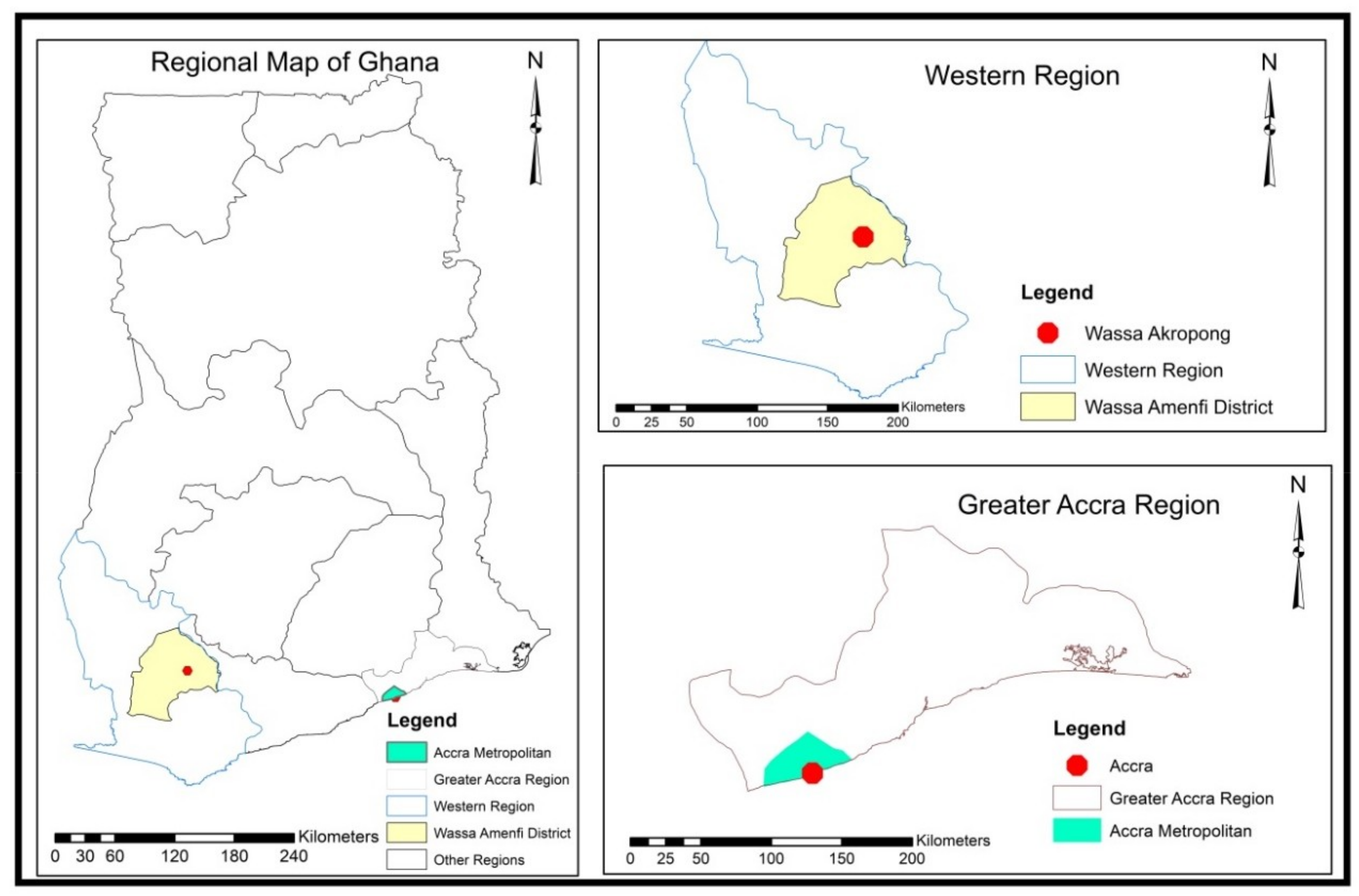
A challenge emerging from the hybridity of land governance institutions in Ghana (customary and statutory) is the non-recording of some customary land rights such as the customary freehold interest by the Lands Commission in the Western Region due to ambiguity of land laws and related multiple interpretations. The indigenous people in Wassa Akropong are believed to hold customary freehold interest from time immemorial and would not like to sacrifice that interest for a lease, since Meridia land tenure documentation packages are only based on leases. In this case, Meridia has to adjust and adapt to the existing situation by providing customary documentation packages.

4.3.3. Encounters with the Dynamics of Land and Livelihoods

In developing innovative processes to register land rights, Meridia also needs to engage with and adjust to the dynamics outside of statutory and customary land governance institutions per se. These dynamics include the seasonal variations associated with agricultural livelihoods, for instance income fluctuations.
The Wassa Akropong traditional area is a cocoa growing zone where the income of the people varies by season. The main harvesting period for cocoa in Ghana is from October to February and from May to August for the light crop. During the main harvesting period, the farmers have the money to pay for the tenure documentation fees. During the light cropping, the farmers do not have enough money to pay Meridia for their services. Therefore, Meridia collects part payment from those farmers, who cannot afford payment during low income periods. These farmers are then obliged to pay the money during the major cocoa harvesting periods.
But also the distribution of land rights is more dynamic than GPS-based survey logic may anticipate, as farming practices and related use rights vary with natural circumstances and the amount of labor put into clearing and preparing fields. When engaging in mapping activities, it turns out that some of the farmers had reported a different size and boundary during the interviews than what was found later during mapping work. There could be different reasons for these discrepancies. For example, farmers may not know the sizes and boundaries of their lands in acreages. Until recently, the acquisition of land by indigenes was based on one’s ability to farm the land. In other words, how much land one farmed and put to productive uses came to constitute one’s land size and boundaries. It is the work that makes the boundaries, not the boundaries that allow (give the “right” to) a certain kind of work. Whatever the reasons may be for the mismatch between land sizes as reported during the interviews and the boundaries and sizes measured during the mapping work, the fees to be paid for documentation are charged based on the information provided earlier by the farmer during interview. These discrepancies can therefore lead to substantial problems and delays in the process of documentation. Hence, the way Meridia measures and delineates land using GPS may differ from the logic by which the farmers themselves delineate and measure land. However, there is also a close connection between measurement, reporting of land size, and the negotiations over documentation fees that create a relatively dynamic environment, in which documentation takes place, even in regions that are not characterized by longer term land conflicts or illegal resources extraction activities, which constitute another layer of complex dynamics to land tenure registration.

5. Discussion: Innovating Along a Continuum of Land Rights Recognition

Increasingly, civil society and international organizations in developing countries are making efforts to document land rights, since national governments are slow in capturing and documenting existing land rights. For example, in Zambia, there are about five civil society and private organizations documenting customary land rights in a bottom-up manner [23]. In the case of Ghana, Meridia seeks to fulfil such an augmenting role in land rights documentation. On the basis of our findings in the previous section, Meridia’s case allows us to reflect on two elements that are relevant to the current debates to innovate land administration through fit-for-purpose approaches inspired by the continuum of land rights [6]. First, we can reflect on the nature of innovation in the domain of land tenure registration as it presents itself in Meridia’s case. Second, we reflect on the documentation packages created and marketed by Meridia according to three dimensions: costs and level of complexity of certification, level of usability of certificate, and the recognition of certificates.
Meridia’s product innovation takes place in dialogue with Ghana’s existing customary and statutory scene. This process is characterized by incremental learning from the challenges that Meridia and associated actors face and by inventing solutions to these challenges more or less on-the-go. The products developed by Meridia are therefore inventions that become possible only in response to the contingencies of the context. The descriptions of the processes and encounters between innovation and institutions in Section 4 above illustrate that the diffusion and invention of ideas and technologies are always two sides of the same coin [24]. Meridia’s is a case of innovation that comes closest to models of “coupling” in Rothwell’s models of innovation. According to this model, innovation consists of a sequential process but involves feedback loops and various push/pull combinations with emphasis on the integration of invention, on one hand, and market, on the other [24]. As such, Meridia’s interventions appear less disruptive to the existing institutional framework of both the Lands Commission and the traditional authorities. Meridia’s activities target only the most problematic aspects of the existing registration processes without setting new operational standards. This approach has somewhat eliminated or reduced the frictions that often ensue between innovation and existing institutions [25]. Research on the adaptation of land administration to the institutional framework of customary tenure in peri-urban Ghana and Sub-Saharan Africa at large highlights the dynamism of customary land tenure institutions [26,27]. According to Arko-Adjei [26] in such a dynamic as well as the complex environment, a non-rigid institutional framework is required to allow innovation in land administration processes to take place. As such Arko Adjei argues for institutional flexibility in the context of both statutory and customary domains to allow innovation to take place. Institutional flexibility denotes the various flexible processes and procedures adopted for land administration [26]. According to Amanor [28], accessibility to land and management of land in a customary land tenure setup is based on negotiations as well as local knowledge, both of which require institutional flexibility. The negotiations also relate to signing fees, or the price for the purchase of land to mention a few. In the case of Ghana, these two authors’ position indicates that institutional flexibility is one of the premises for innovation to take place. Meridia’s case seems to confirm and illustrate this view. The company’s less disruptive strategies are partially dependent on opportunities for flexibility embedded in the existing institutional set-up of statutory and customary tenure in Ghana and also more generally in Sub-Saharan Africa as demonstrated in the study of Sommerville [23] for Zambia. In Section 4, we identify several characteristics that run through the existing statutory and customary institutional scene, which enable innovation to take place. These are mostly related to a degree of flexibility provided by the customary arrangements, for instance the possibility to negotiate signing fees and the presence of an active land governance structure in the study area in form of the Customary Land Secretariats (CLSs) and their mediators. However, also the statutory institutional sphere allows for some flexibility. Monuments are generally used to carry out survey work in Ghana to mark boundary points but are difficult to carry as well as to set up. They are, in this sense, a quite literal and tangible symbol of the rigidity of statutory survey norms. The institutional setting provides some flexibility here regarding the monumentation of farmlands, by allowing Meridia to improvise through the use of PVC pipes as monuments.
The benefits of land rights documentation are many and vary according to different purposes of documentation. Some of the benefits credit access, tenure security, and investment [29,30]. However, our study does not provide empirical insights regarding the uses and benefits of Meridia’s documentation packages, because certificate holders only recently obtained the certificates and at the time of fieldwork they had not yet tried to use the certificates to obtain any benefits or services. Some of the perceived uses of Meridia certificates mentioned in focus groups by the Meridia land certificate holders include access to finance, increased legal security, and lastly a source of motivation for farm level investment. However, we may infer potential degree of usability of the certificates from the descriptions of the documentation packages and related process descriptions in Section 4 of this paper. Figure 4 below present a conceptualization of the documentation packages along three axes: amount of cost and complexity involved in preparing the respective certificate, the type of recognition the certificate receives, that is, by customary or both customary and statutory actors, as well as the usability of the certificate and related exchangeability of the associated land parcel. By virtue of the continuum of registration packages, the usability of Meridia’s certificates and parcel exchangeability span across a continuum of local to national arenas. For example, when landholders opt for a FarmSeal or FarmSeal+, the potential usability of the certificate in providing security or accessing finance is likely to be higher within the local community than outside of the community, since these certificates are locally verifiable. However, as one moves towards the HomeSeal and OrgSeal, which received also statutory recognition, the usability of the certificates in securing tenure and accessing credit becomes widened, as transacting parties can easily verify the ownership status from the Lands Commission (at the regional level). Similarly, parcel exchangeability is enhanced beyond the community with respect to the HomeSeal and OrgSeal, as compared to the FarmSeal and FarmSeal+. As recognition increases to include recognition of the respective certificate by both customary and statutory institutions, usability of the certificate and exchangeability are likely to increase but so do the costs in terms of finances and labor as well as the complexity of the processes of preparing the package and issuing the respective certificate. The holders of Meridia’s certificates show high hopes of benefitting from the documentation in the form of tenure security and credit access from farmer cooperatives and even cocoa buying companies. However, this is yet to be observed in practice.
At an abstract level then, we can read Meridia’s efforts as a kind of product innovation, which diversifies the processes of land tenure registration along the a continuum of land rights, by means of variations in the fee structures and economy of land rights documentation with the two-fold aim of affordability and the company’s own financial sustainability.

6. Conclusion and Future Research Directions

Meridia’s case shows that at the meeting point of innovation and existing institutions, the latter prompt both in situ and on-the-go solutions through challenges but also enable innovation through institutional flexibilities in both statutory and customary domains. According to Barry’s [11] call to identify critical success factors, our study indicates, as one such factor, the identification of “nodes of flexibility” across customary and statutory institutions, which would enable the creation of action nets [31,32] around new ideas and emerging practices. The nature of such nodes of flexibility and how to leverage them in a given case are, of course, context dependent. Meridia found various innovative strategies and solutions of social as well as technical nature [33] to address institutional challenges and constraints, which allow Meridia to distil important elements of the registration processes of the Lands Commission’s bureaucratic structure and simplify them. What is also noteworthy in Meridia’s case is the indication of a positive correlation between complexity/cost of registration and level of recognition of a certificate across customary and statutory institutions. More research contributing to the implementation of FFP land administration could focus on the kind of trade-offs that are necessary to be made between the affordability and simplicity of registration, on one hand, and the ability to leverage the existing institutional context in such way as to achieve recognition by a broad range of institutional actors and a broad usability of the certificates, on the other.
While innovation generally carries a positive connotation, e.g. increasing performance and effectiveness of organizations [34,35], Taylor [36], for instance, points out that not all innovation is good for everyone and that researchers would do well “to take into account different currents of public resistance to innovation.” The challenges of and responses by the existing institutional context therefore also tell us something about the nature of the innovation itself and what kind of innovation is desirable in a given application and development context. New processes and emerging practices of land tenure documentation provide an opportunity for a critical and balanced engagement with the longer term politico-economic effects and implications of such innovation and, as in Meridia’s case, provides opportunity for incremental learning and adjustment.
Future empirical research should therefore be conducted on similar processes of implementation at the nexus of innovation and institutional context, also in the form of comparative research. An important criterion for comparison is various financing mechanisms and related to this is the question of sustainability of an initiative. For instance, financing mechanisms of an initiative, especially for-profit, may come to influence land tenure related financial economics through induced changes in fee structures and corresponding beneficiaries. This, in turn, is likely to influence also land holders’ political identities, as these are related to the financial mechanisms. For example, depending on the financial set up of land tenure document, a land holder may receive a document either as citizens (in return for taxes paid, for example), as customers of a product, as extended family member, or as the end user of a technology. Each of these roles has different implications on people’s relationships to land. Related to this is the need to investigate in how far these initiatives really benefit the intended beneficiaries and/or if the groups who benefit actually change through the process of implementation. Although innovative approaches seem to enhance tenure security, the extent to which land documentation certificates generated through such processes can be used as a legal document is still unclear. The intended beneficiaries of innovation in land documentation need to see and experience benefits of documenting their lands in the long run, also because registration systems work when there are apparent benefits for the intended beneficiaries [37]. Our study does not provide much insight on the specifics of digital data storage and sharing in new initiatives, such as Meridia’s, to register land tenure. Given the reliance on digital data technologies in these innovative approaches, questions related to digital data storage need to be addressed as access to storage and uses of data influence power dynamics and actors’ roles and agency in land governance. Empirically, and in the longer run, such questions include the following: What happens to the generated data of those initiatives in the long run? Who is currently in possession of and responsible for the generated data of those initiatives and what are the various uses? What are the security issues in relation to data capture and storage?
Addressing these questions in research and evaluation of new initiatives to document land tenure offers the opportunity to chart out ways towards what Winner [38] calls “graceful or benign innovation,” which, rather than seeking to be disruptive, is built on the respect for what came before and modifies and renews traditions and practices into fruitful possibilities.

Author Contributions

Conceptualization: F.W.S., Z.A., C.R.; methodology: F.W.S., formal analysis: F.W.S., Z.A., C.R.; investigation: F.W.S.; writing—original draft: F.W.S., review and editing: F.W.S., Z.A., C.R.; supervision: C.R.

Funding

This research received no external funding.

Conflicts of Interest

The authors declare no conflict of interest.

References

  1. Lemmen, C. The Social Tenure Domain Model the Social Tenure Domain Model: A Pro-Poor Land Tool; FIG Publication 52: Copenhagen, Denmark, 2010. [Google Scholar]
  2. Byamugisha, F.F.K. Securing Africa’s Land for Shared Prosperity: A Program to Scale Up Reforms and Investments; Africa Development Forum Series 78085: Washington, DC, USA, 2013. [Google Scholar]
  3. Toulmin, C. Securing land and property rights in sub-Saharan Africa: The role of local institutions. Land Use Policy 2009, 26, 10–19. [Google Scholar] [CrossRef]
  4. Benjamin, S.; Bhuvaneswari, R.; Rajan, P. Bhoomi: ‘E-Governance’, Or, an anti-Politics Machine Necessary to Globalize Bangalore? CASUM-m Working Paper. 2007. [Google Scholar]
  5. Meinzen-Dick, R.; Mwangi, E. Cutting the web of interests: Pitfalls of formalizing property rights. Land Use Policy 2009, 26, 36–43. [Google Scholar] [CrossRef]
  6. Secure Land Rights for All-UN-Habitat. Available online: https://mirror.unhabitat.org (accessed on 21 May 2019).
  7. Bennett, R.M.; Alemie, B.K. Fit-for-purpose land administration: Lessons from urban and rural Ethiopia. Surv. Rev. 2016, 48, 11–20. [Google Scholar] [CrossRef]
  8. Enemark, S.; Clifford, B.; Lemmen, C.; McLaren, R. Fit-For-Purpose Land Administration; Joint Publication by FIG and World Bank: Copenhagen, Denmark, 2014. [Google Scholar]
  9. Lengoiboni, M.; Richter, C.; Zevenbergen, J. An overview of initiatives to innovate land tenure recordation: 2011 to present. In Proceedings of the World Bank Conference on Land and Poverty, Washington, DC, USA, 19–23 March 2018. [Google Scholar]
  10. McLaren, R.; Fairlie, K.; Kelm, K.; Souza, G.D. New Technology and Emerging Trends: The State of Play for Land Administration. In Proceedings of the World Bank Conference on Land and Poverty, Washington, DC, USA, 19–23 March 2018. [Google Scholar]
  11. Barry, M. Fit-for-purpose land administration—Administration that suits local circumstances or management bumper sticker? Guest Editorial. Surv. Rev. 2018, 50, 383–385. [Google Scholar] [CrossRef]
  12. Abubakari, Z.; Richter, C.; Zevenbergen, J. Exploring the “implementation gap” in land registration: How it happens that Ghana’s official registry contains mainly leaseholds. Land Use Policy 2018, 78, 539–554. [Google Scholar] [CrossRef]
  13. Abubakari, Z.; Richter, C.; Zevenbergen, J. Plural Inheritance Laws, Practices and Emergent Types of Property—Implications for Updating the Land Register. Sustainability 2019, 11, 6087. [Google Scholar] [CrossRef] [Green Version]
  14. Cardinal, A.W. The Natives of the Northern Territories of the Gold Coast: Their Customs, Religion and Folklore; Routlege: London, UK, 1920. [Google Scholar]
  15. Rattray, R.S. The Tribes of the Ashanti Hinterland: (Some Results of a Two-Years Anthropological Survey of the Northern Territories of the Gold Coast). J. R. Afr. Soc. 1931, 30, 40–57. [Google Scholar]
  16. Larbi, W.O.; Antwi, A.; Olomolaiye, P. Compulsory land acquisition in Ghana—policy and praxis. Land Use Policy 2004, 21, 115–127. [Google Scholar] [CrossRef]
  17. Kasanga, K.; Kotey, N. Land Management in Ghana: Building on Tradition and Modernity; International Institute for Environment and Development: London, UK, 2001. [Google Scholar]
  18. Abubakari, Z.; van der Molen, P.; Bennett, R.M.; Kuusaana, E.D. Land consolidation, customary lands, and Ghana’s Northern Savannah Ecological Zone: An evaluation of the possibilities and pitfalls. Land Use Policy 2016, 54, 386–398. [Google Scholar] [CrossRef]
  19. Biitir, S.B.; Nara, B.B.; Ameyaw, S. Integrating decentralised land administration systems with traditional land governance institutions in Ghana: Policy and praxis. Land Use Policy 2017, 68, 402–414. [Google Scholar] [CrossRef]
  20. Bryman, A. Social Research Methods, 4th ed.; Oxford University Press Inc.: New York, NY, USA, 2012. [Google Scholar]
  21. Langley, A. Strategies for Theorizing from Process Data. Acad. Manag. Rev. 1999, 24, 691–710. [Google Scholar] [CrossRef] [Green Version]
  22. Hsieh, H.-F.; Shannon, S.E. Three Approaches to Qualitative Content Analysis. Qual. Health Res. 2005, 15, 1277–1288. [Google Scholar] [CrossRef] [PubMed]
  23. Sommerville, M.; Bouvier, I.; Chuba, B.; Minango, J. Land Documentation in Zambia: A Comparison of Approaches and Relevance For the National Land Titling Program. In Proceedings of the Responsible Land Governance: Towards an Evidence Based Approached, Washington, DC, USA, 20–24 March 2017; World Bank: Washington, DC, USA, 2017. [Google Scholar]
  24. Godin, B. Models of Innovation—The History of an Idea; MIT Press: London, UK, 2017. [Google Scholar]
  25. Govindarajan, V.; Kopalle, P.K. Disruptiveness of innovations: Measurement and an assessment of reliability and validity. Strateg. Manag. J. 2006, 27, 189–199. [Google Scholar] [CrossRef]
  26. Arko-Adjei, A. Adapting Land Administration to the Institutional Framework of Customary Tenure: The Case of Peri-Urban Ghana; University of Twente: Enschede, The Netherlands, 2011. [Google Scholar]
  27. Van Asperen, P. Evaluation of Innovative Land Tools in Sub-Saharan Africa: Three Cases from a Peri-Urban Context; IOS Press: Amsterdam, The Netherlands, 2014; ISBN 9781614994442. [Google Scholar]
  28. Amanor, K. The Changing Face of Customary Land Tenure. In Contesting land and custom in Ghana: State, Chief and the Citizen; Ubink, J.M., Amanor, K.S., Eds.; Leiden University Press: Leiden, 2008; pp. 55–81. [Google Scholar]
  29. De Soto, H. The Mystery of Capital: Why Capitalism Triumphs in the West and Fails Everywhere else; Basic Books: London, UK, 2000; ISBN 0465016154. [Google Scholar]
  30. Feder, G.; Nishio, A. The benefits of land registration and titling: Economic and social perspectives. Land Use Policy 1999, 15, 25–43. [Google Scholar] [CrossRef]
  31. Czarniawska, B. Organizational Translations. In Facts and Figures. Economic Representations and Practices; Kalthoff, H., Rottenburg, R., Wagener, H.-J., Eds.; Metropolis: Marburg, Germany, 2000. [Google Scholar]
  32. Czarniawska, B. On Time, Space, and Action Nets. Organisation 2004, 11, 773–791. [Google Scholar] [CrossRef] [Green Version]
  33. Bowker, G.C.; Baker, K.; Millerand, F.; Ribes, D. Towards Information Infrastructure Studies: Ways of Knowing in a Networked Environment. In International Handbook of Internet Research; Hunsinger, J., Klastrup, L., Allen, M.M., Eds.; Springer: London, UK, 2010. [Google Scholar]
  34. Hult, G.T.; Hurley, R.F.; Knight, G. Innovativeness: Its Antecedents and Impact on Business Performance. Ind. Mark. Manag. 2004, 33, 429–438. [Google Scholar] [CrossRef]
  35. Verhees, F.J.H.M.; Meulenberg, M.T.G. Market Orientation, Innovativeness, Product Innovation, and Performance in Small Firms. J. Small Bus. Manag. 2004, 42, 134–154. [Google Scholar] [CrossRef]
  36. Taylor, L. What is data justice? The case for connecting digital rights and freedoms globally. Big Data Soc. 2017, 1–14. [Google Scholar] [CrossRef] [Green Version]
  37. Szreter, S.; Breckenridge, K. Recognition and Registration: The Infrastructure of Personhood in World History. In Registration and Recognition: Documenting the person in World History; Oxford University Press: Oxford, 2012; pp. 1–38. ISBN 9780191760402. [Google Scholar]
  38. Winner, L. The Cult of Innovation: Its Myths and Rituals. In Engineering a Better Future; Subrahmanian, E., Odumosu, T., Tsao, J.Y., Eds.; Springer: Cham, Switzerland, 2018. [Google Scholar]
1
A stool is a local construct to depict the chieftaincy institution. Section 139 of the Land Title Registration Law, 1986, interprets “Stool" to include “skin” and any person or people having control over skin or community land including family land, as a representative of the particular community. “Stool” is a symbol of authority for chiefs in the southern part of Ghana as such the lands are called “stool lands”. “Skin” is a symbol of authority for chiefs in most Northern part of Ghana as such the lands are called “skin lands”. Sometime the term “stool” is used to depict both stool and skin.
Figure 1. Map of the study area.
Land 08 00189 g001
Figure 2. Processes of preparing FarmSeal and FarmSeal+ (constructed on the basis of interviews with Meridia respondents).
Land 08 00189 g002
Figure 3. Flowchart of documenting HomeSeal and OrgSeal. This is constructed on the basis of interviews with Meridia. CSAU: Client Service Access Unit. SMD: Survey and Mapping Division. LVD: Land Valuation Division. LRD: Land Registration Division.
Land 08 00189 g003
Figure 4. Continuums of cost, usability, transferability, and legitimacy of documentation packages.
Land 08 00189 g004
Table 1. Categories of respondents.
InstitutionsTotal Sampled SizeData Collection Methods
Lands Commission4semi-structured interviews
Meridia5semi-structured interviews
Traditional Authorities (Chiefs)5semi-structured interviews
Customary Land Secretariats1semi-structured interviews
Waasa Akropong Community13Focus group Discussion
Total28

