The River as an Economic Asset: Settlement and Society in the Xeros Valley in Cyprus


Abstract
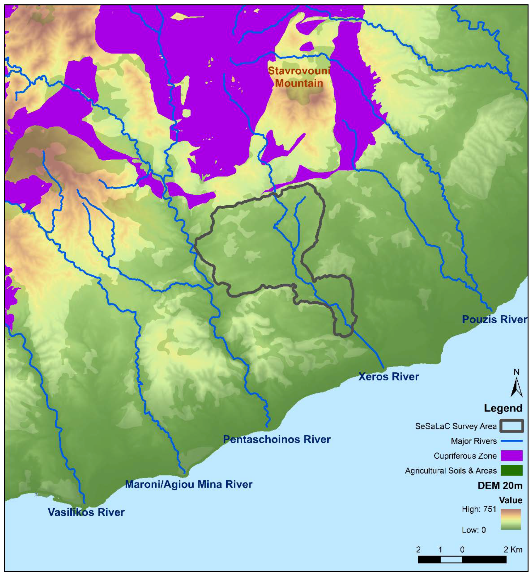
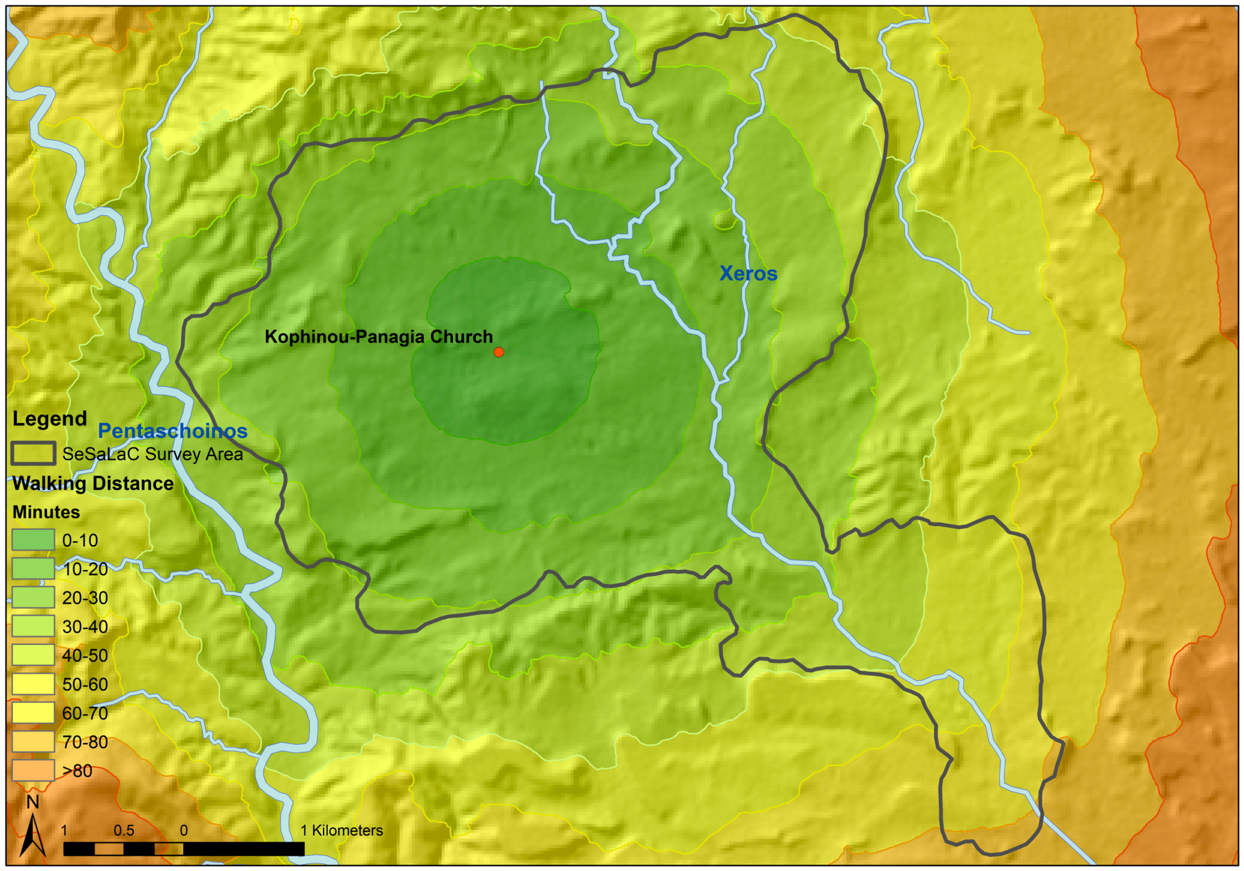
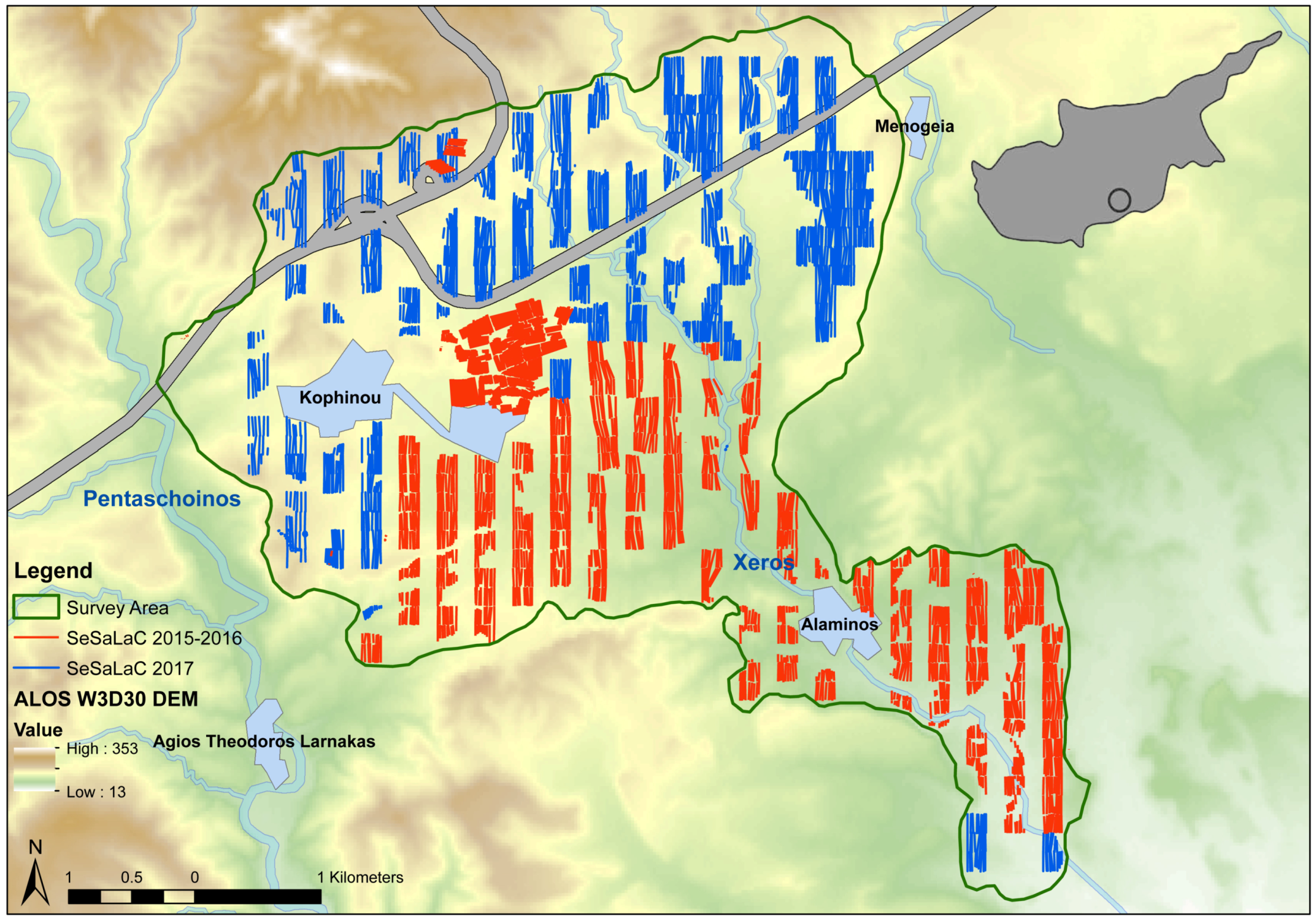
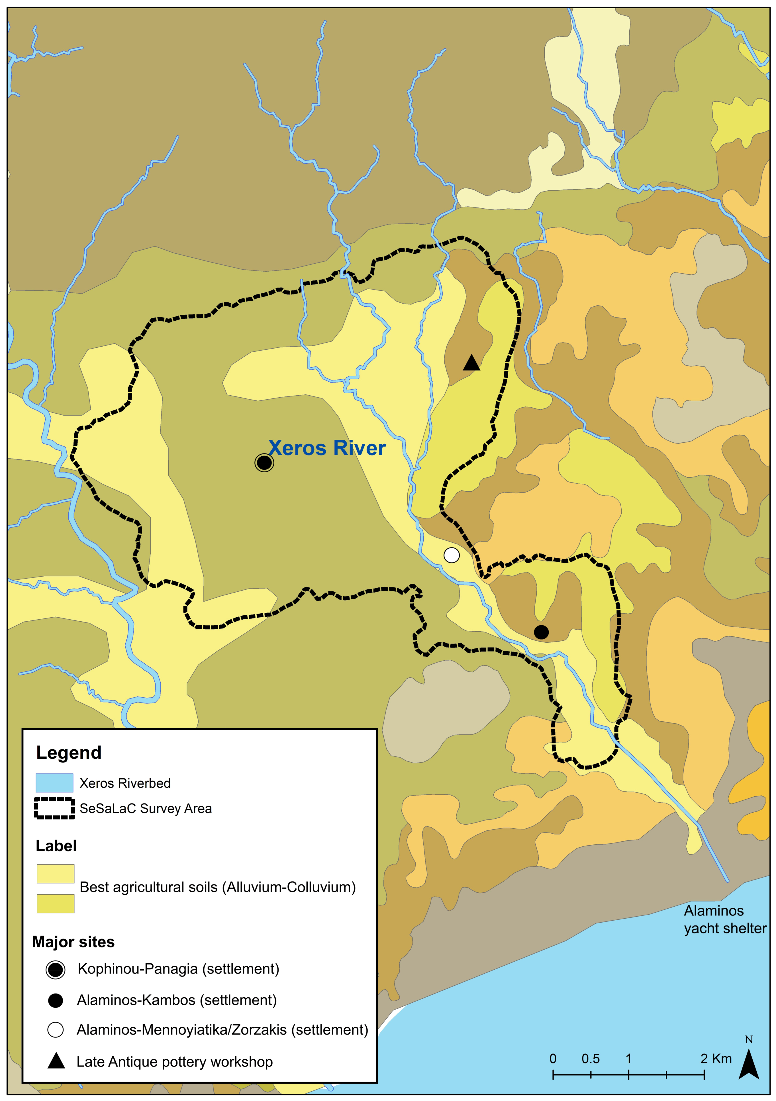
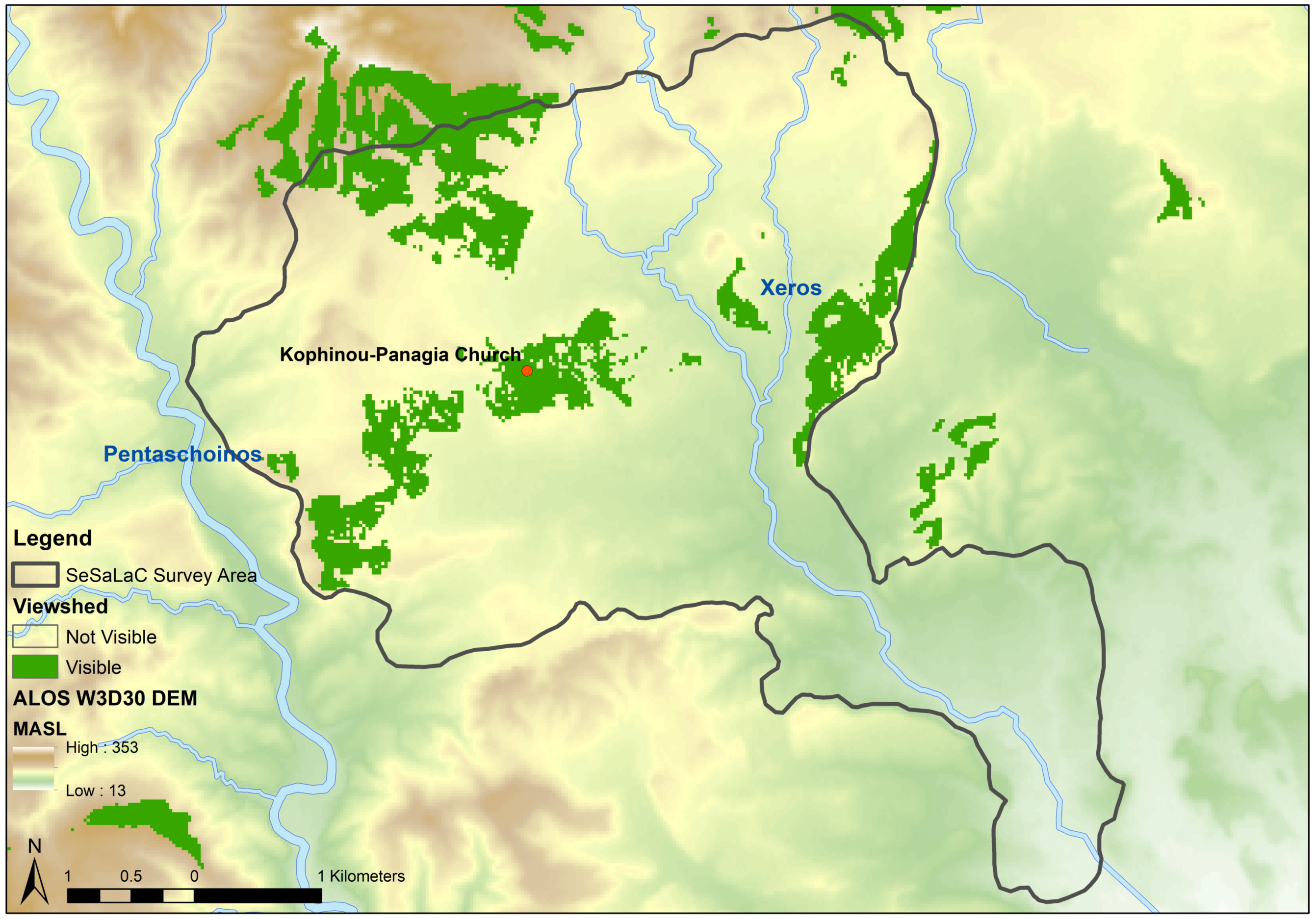
:1. Introduction: Settled and Sacred Landscapes of Cyprus (SeSaLaC)
2. Settlements Systems in the Xeros Valley from Prehistory to Late Antiquity
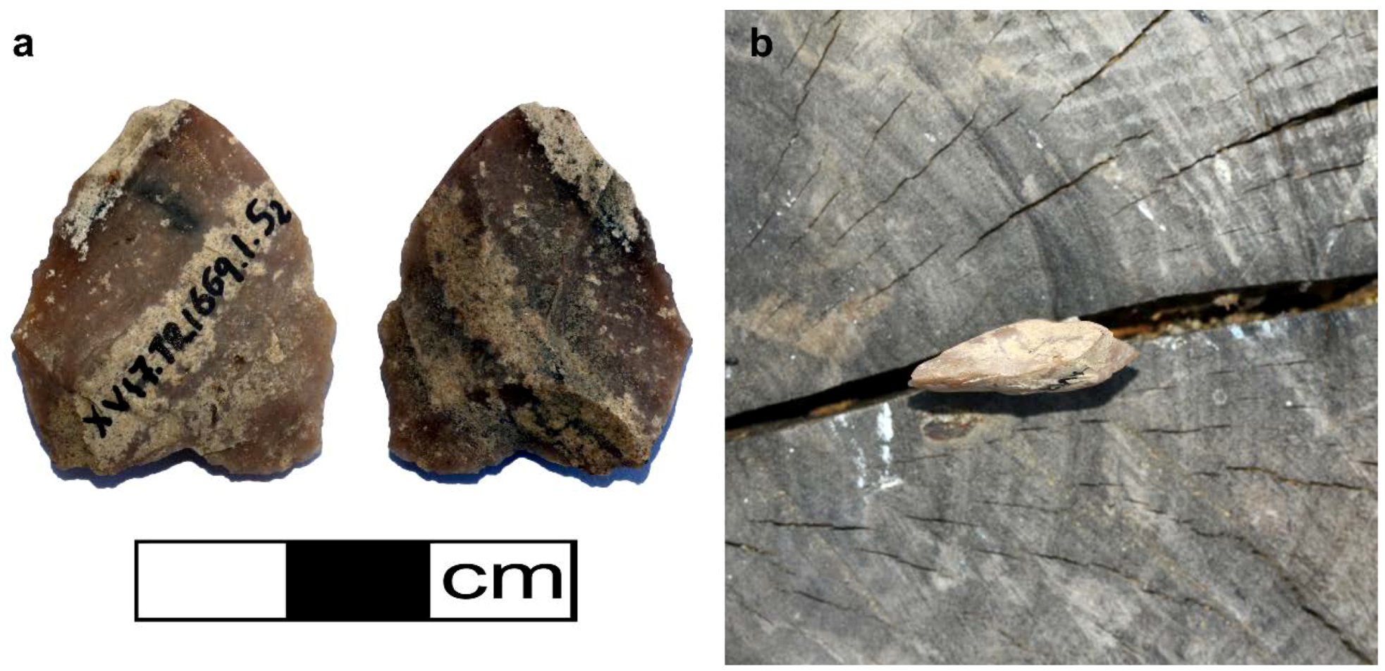
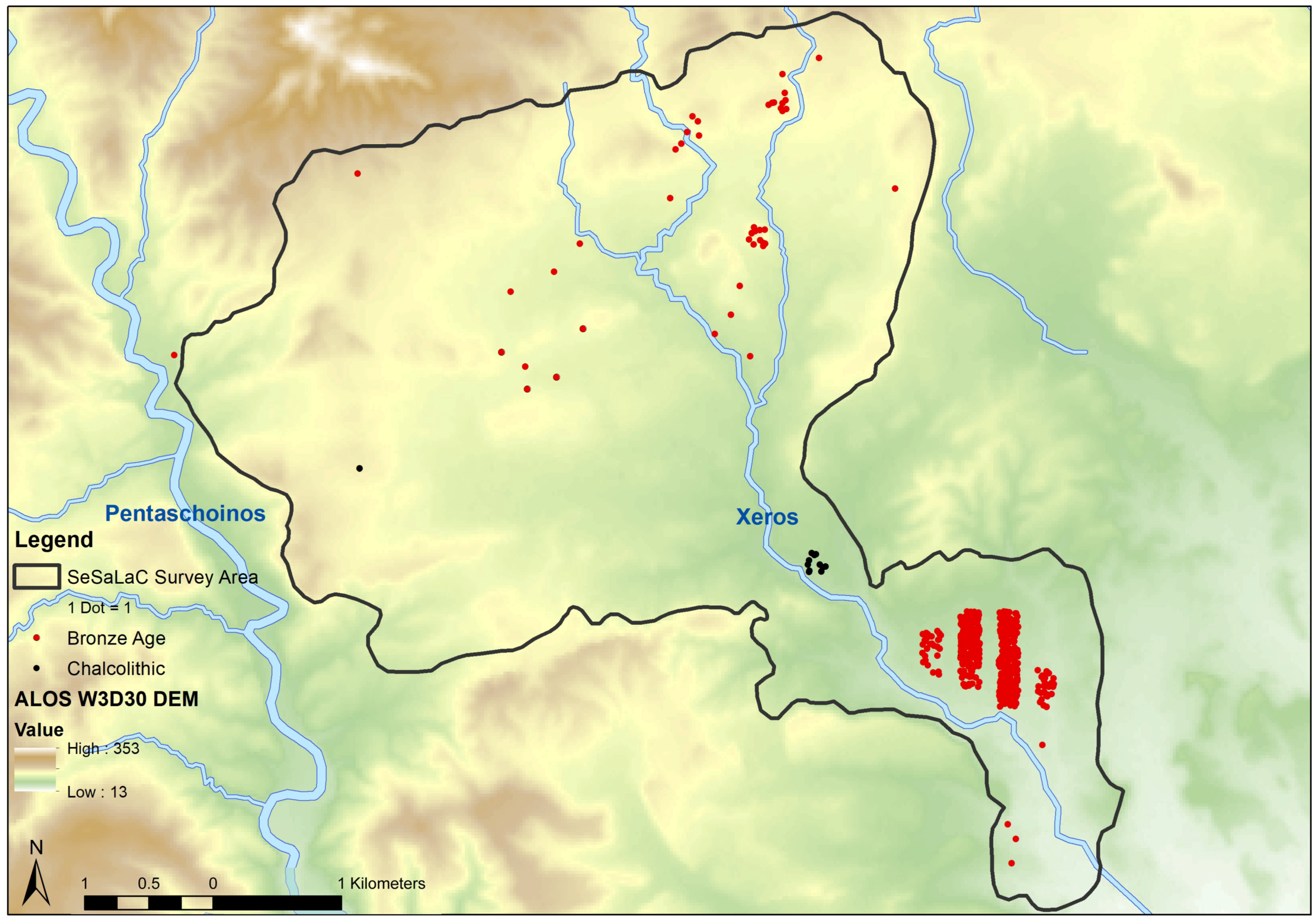
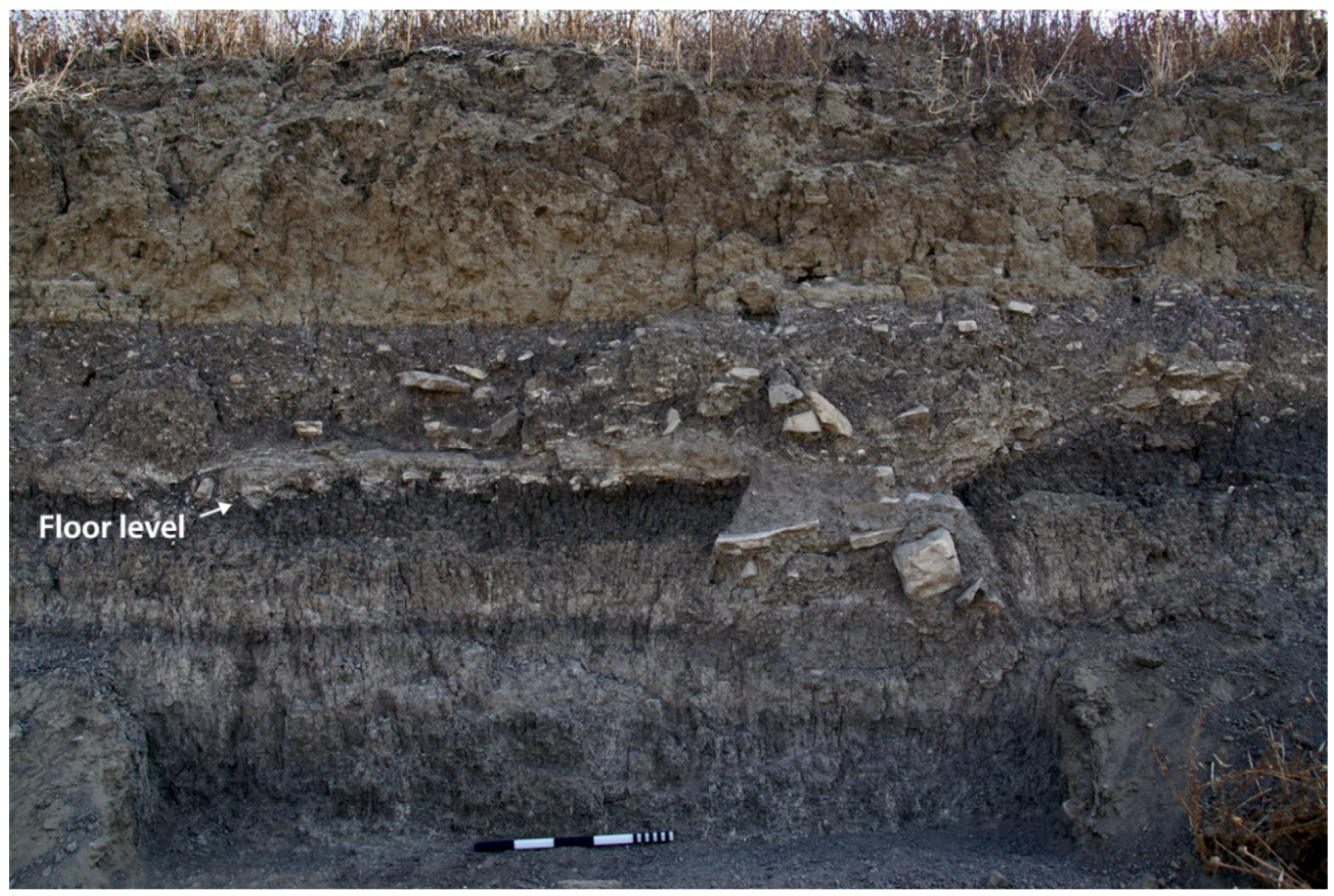
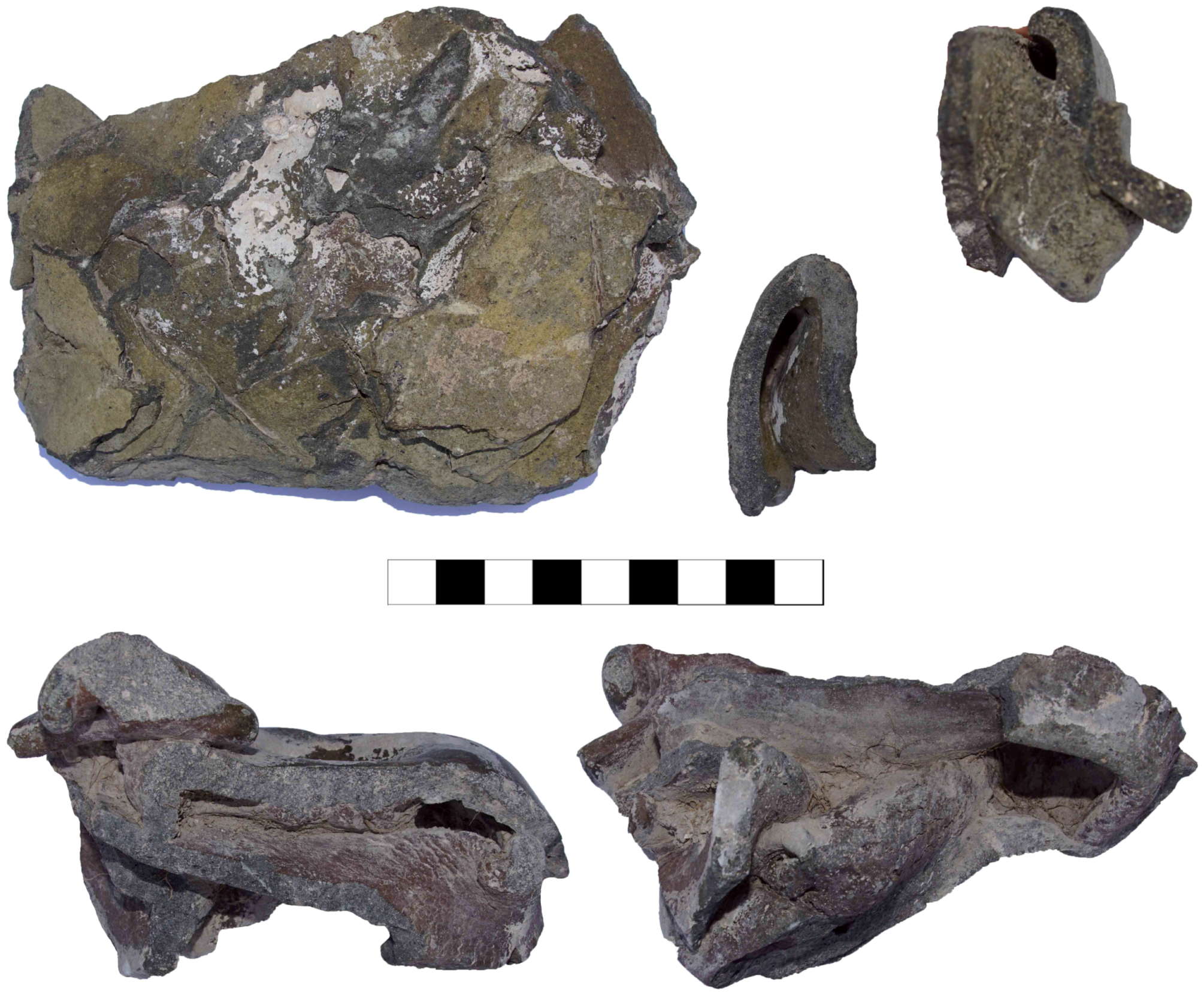
2.1. Before the Early Bronze Age
2.2. Early and Middle Bronze Age
2.3. Late Bronze Age
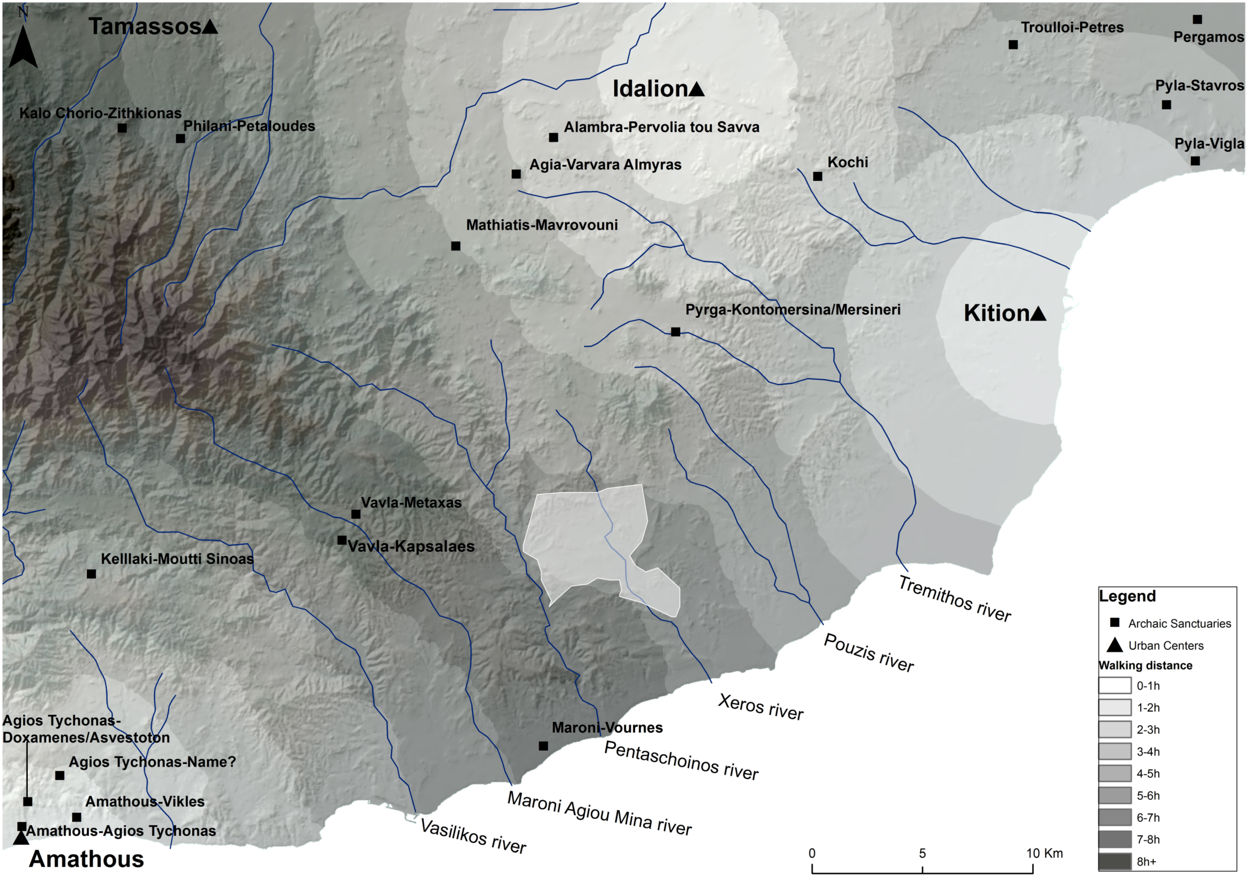
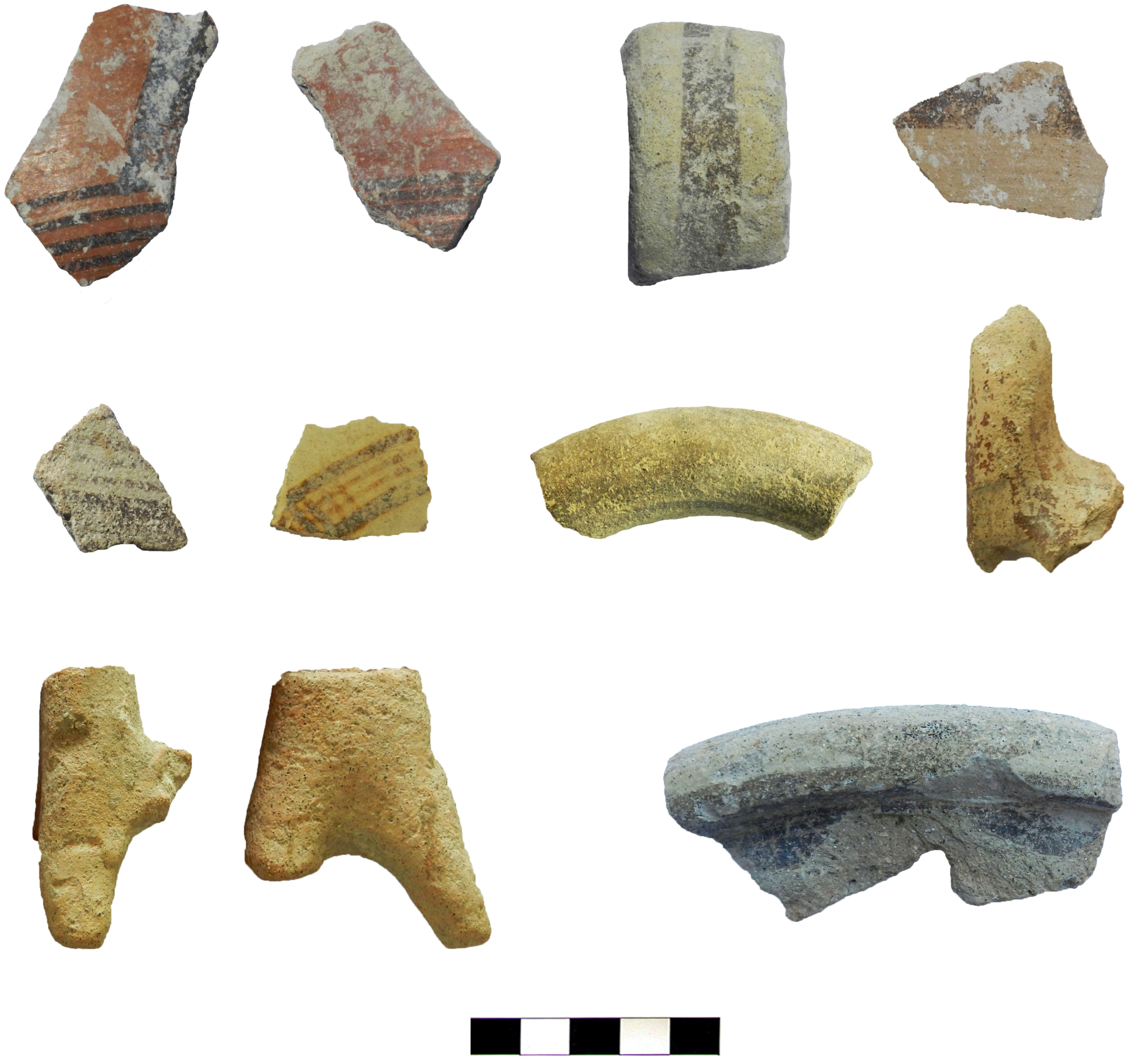
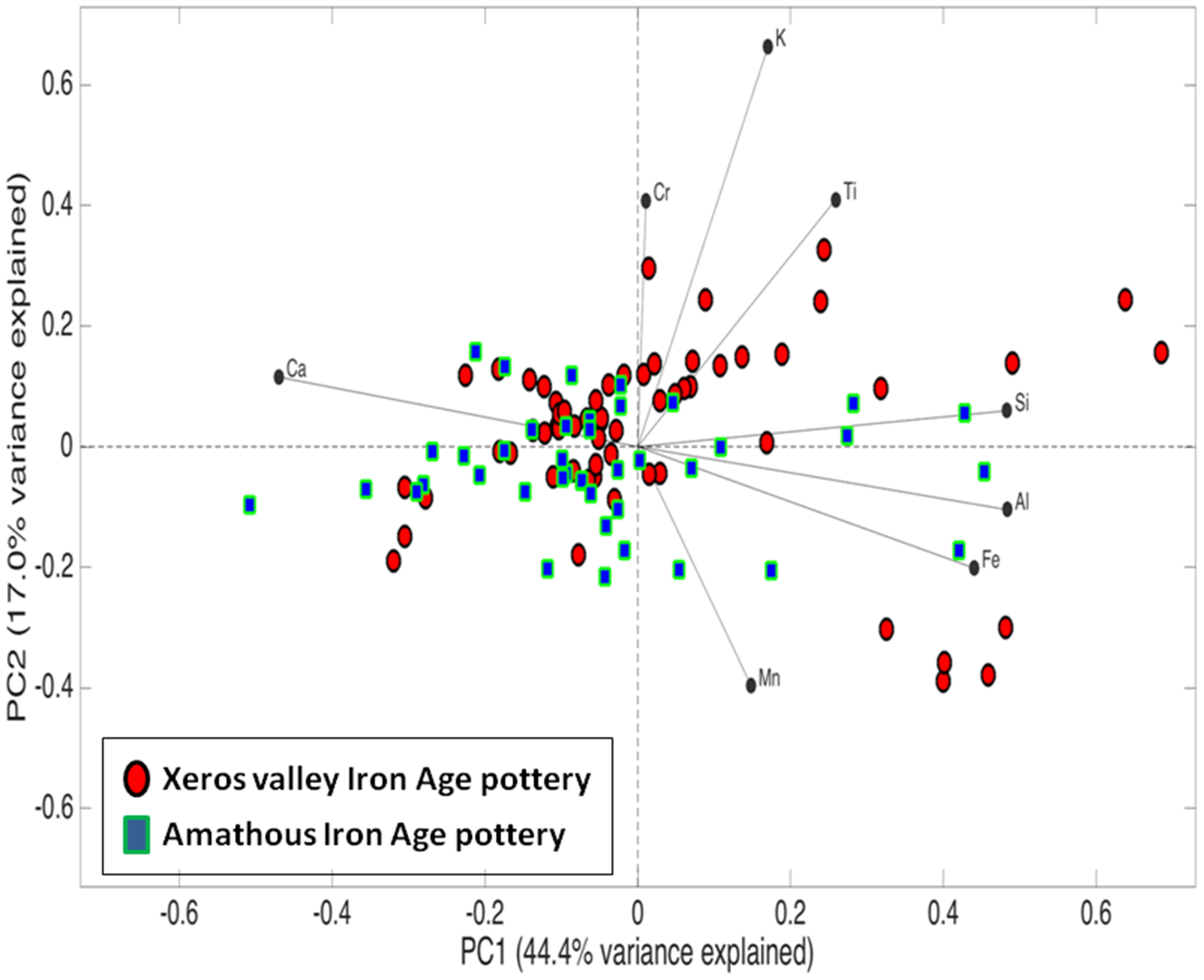
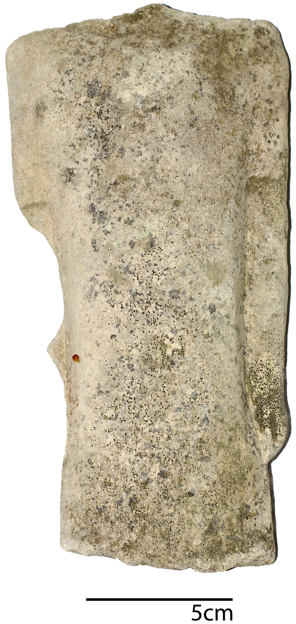
2.4. The Cypriot Iron Age
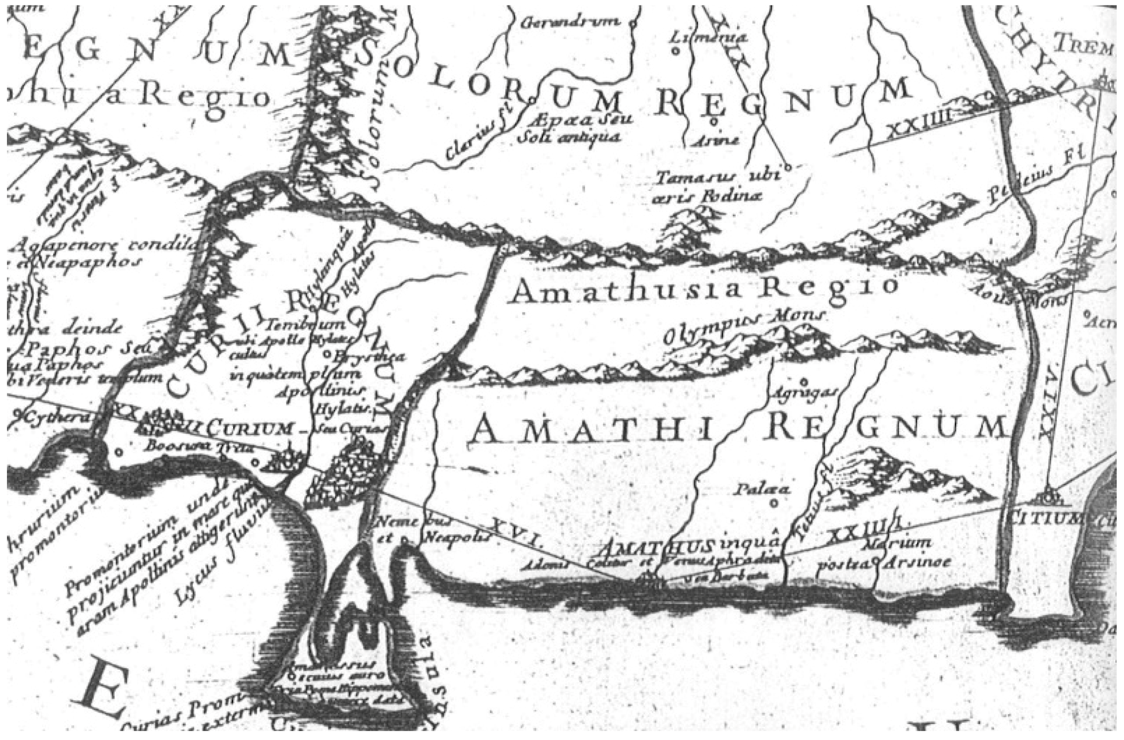
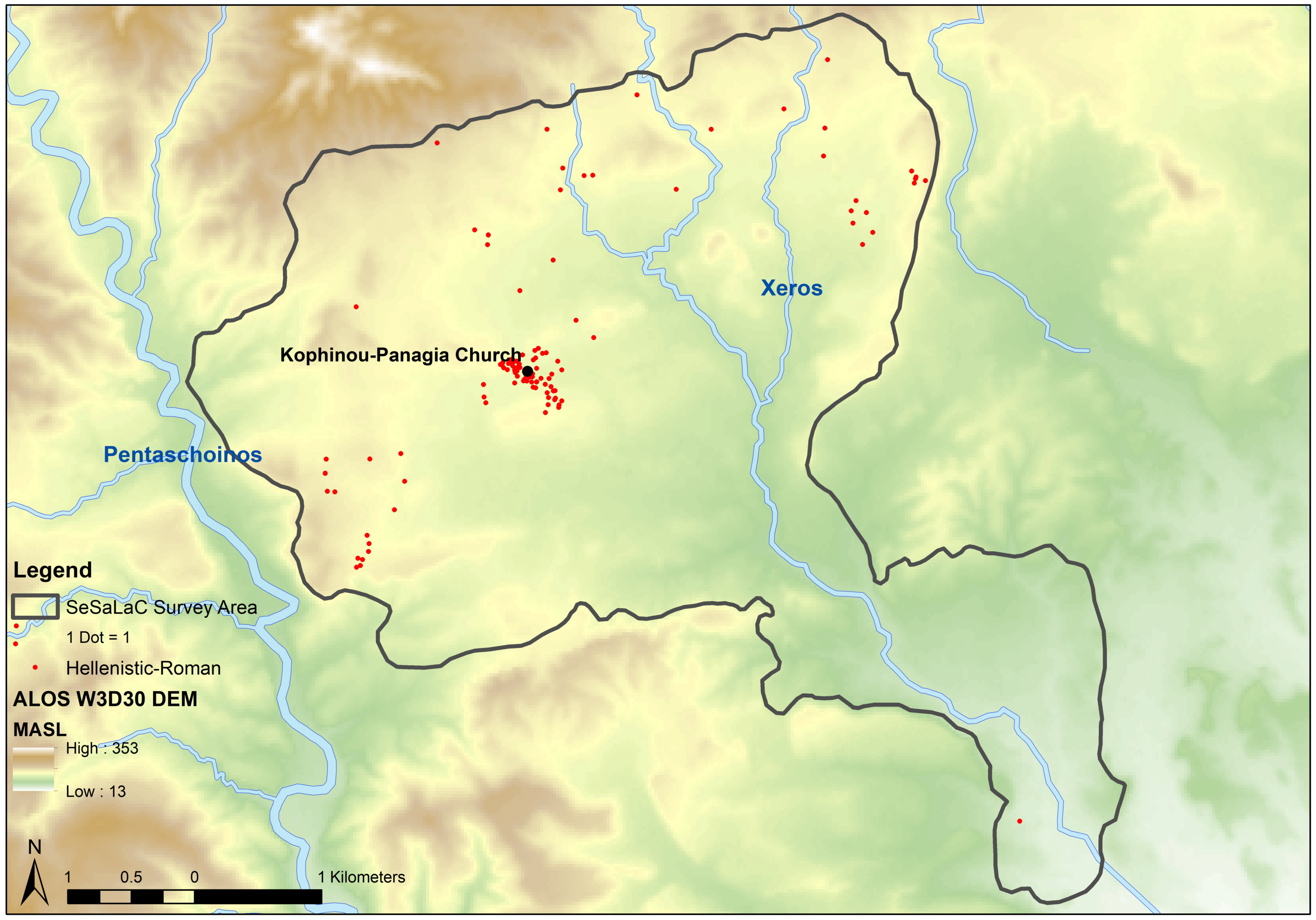
2.5. Hellenistic and Roman Periods
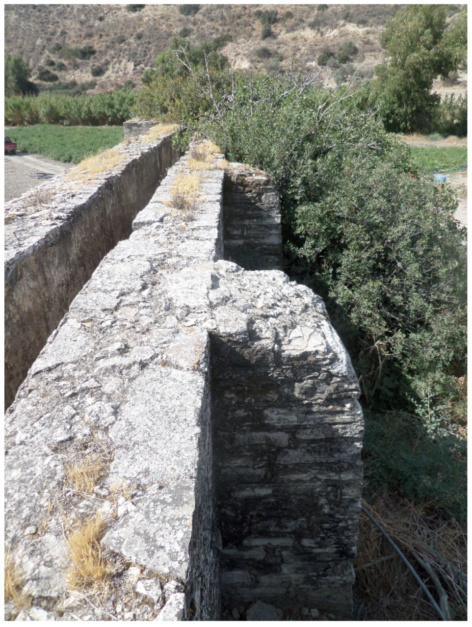
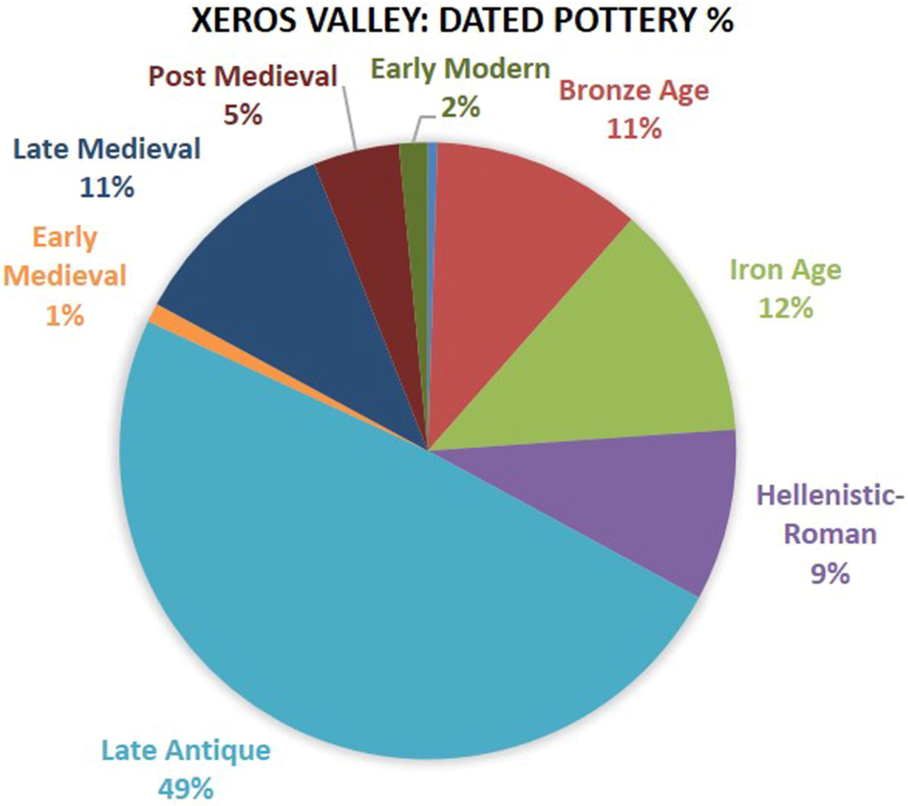
2.6. Late Antiquity
3. Conclusions
Author Contributions
Funding
Acknowledgments
Conflicts of Interest
References
- Foxhall, L. The dependent tenant: Land leasing and labour in Italy and Greece. J. Rom. Stud. 1990, 80, 97–114. [Google Scholar] [CrossRef]
- Pettegrew, D. Chasing the classical farmstead: Assessing the formation and signature of rural settlement in Greek landscape archaeology. J. Mediterr. Archaeol. 2001, 14, 189–209. [Google Scholar] [CrossRef]
- Bintiliff, J.L. Problems of chronology and function in survey assemblages: The 1999 Hidden Landscape debate reviewed. In Hidden Landscapes of Mediterranean Europe: Cultural and Methodological Biases in Pre- and Protohistoric Landscape Studies: Proceedings of the International Meeting Siena, Italy, 25–27 May 2007; British Archaeological Reports, International Series 2320; van Leusen, M., Pizziolo, G., Sarti, L., Eds.; Archaeopress: Oxford, UK, 2011; pp. xv–xix. ISBN 978-1407309033. [Google Scholar]
- Papantoniou, G.; Kyriakou, N. Sacred landscapes and the territoriality of Iron Age Cypriot polities: The applicability of GIS. Am. J. Archaeol. 2018, 122, 541–577. [Google Scholar] [CrossRef]
- Andreou, G.M. Understanding the urban landscape of Late Bronze Age Cyprus: A diachronic perspective from the Vasilikos Valley. J. Mediterr. Archaeol. 2016, 29, 143–172. [Google Scholar] [CrossRef]
- Iacovou, M. Historically elusive and internally fragile island polities: The intricacies of Cyprus’s political geography in the Iron Age. Bull. Am. Sch. Orient. Res. 2013, 370, 15–47. [Google Scholar] [CrossRef]
- Papantoniou, G.; Vionis, A.K. Landscape archaeology and sacred space in the eastern Mediterranean: A glimpse from Cyprus. Land 2017, 6, 40. [Google Scholar] [CrossRef]
- Karyda, E. Sailing from coast to coast: Cabotage on the Cypriot south coast. In Approaching Cyprus, Proceedings of the Post-Graduate Conference of Cypriot Archaeology (PoCA), Norwich, UK, 1–3 November 2013; Maguire, R., Chick, J., Eds.; Cambridge Scholars Publishing: Cambridge, UK, 2016; pp. 78–95. ISBN 978-1-4438-9477-7. [Google Scholar]
- Brown, M. Waterways and the political geography of south-east Cyprus in the second millennium BC. Annu. Br. Sch. Athens 2013, 108, 121–136. [Google Scholar] [CrossRef]
- Devillers, B. Holocene Morphogenesis and Anthropisation of a Semi-Arid Watershed, Gialias River, Cyprus; British Archaeological Reports, International Series 1775; Archaeopress: Oxford, UK, 2008; ISBN 978-1-4073-0263-8. [Google Scholar]
- Steel, L. Watery entanglements in the Cypriot hinterland. Land 2018, 7, 104. [Google Scholar] [CrossRef]
- Knapp, A.B. Seafaring and Seafarers in the Bronze Age Eastern Mediterranean; Sidestone Press: Leiden, The Netherlands, 2018; ISBN 9789088905544. [Google Scholar]
- Andreou, G. Monitoring the impact of coastal erosion on archaeological sites: The Cyprus ancient shoreline Project. Antiquity 2018, 92, 361. [Google Scholar] [CrossRef]
- Andreou, G.M.; Georgiou, A.; Urban, T.; Fisher, K.D.; Manning, S.D.; Sewell, D.A. Reconsidering coastal archaeological sites in Late Bronze Age Cyprus: Tochni-Lakkia and the south-central coastscape. Bull. Am. Sch. Orient. Res. 2018, in press. [Google Scholar]
- Hadjikoumis, A. Ethnoarchaeology as a means of improving integration: An ethnozooarchaeological study from Cyprus and its contribution to the integration of zooarchaeology with archaeobotany and other lines of archaeological evidence. In Environmental Archaeology. Interdisciplinary Contributions to Archaeology; Pişkin, E., Marciniak, A., Bartkowiak, M., Eds.; Springer: Cham, Switzerland, 2018; pp. 181–198. ISBN 978-3-319-75081-1. [Google Scholar]
- Vionis, A.K.; Papantoniou, G. Central place theory reloaded and revised. Land 2018. in submission. [Google Scholar]
- Dikaios, P. La civilisation néolithique dans l’ile de Chypre. Syria 1936, 17, 356–364. [Google Scholar] [CrossRef]
- Dikaios, P. Außerordentliche Sitzung. Montag, Den 21. September 1936. J. Ethnol. 1936, 68, 380–390. [Google Scholar]
- Dikaios, P.; Seton-Williams, V.; Guest, E.M.; Rix, M. The excavations at Erimi, 1933–1935: Final Report. Rep. Dep. Antiq. Cyprus 1936, 1–81. [Google Scholar]
- Knapp, A.B. The Archaeology of Cyprus: From Earliest Prehistory through the Bronze Age; Cambridge University Press: Cambridge, UK, 2013; ISBN 978-0-521-72347-3. [Google Scholar]
- Steel, L. Cyprus before History. From the Earliest Settlers to the End of the Bronze Age; Duckworth: London, UK, 2004; ISBN 0-7156-3164-0. [Google Scholar]
- Annual Report of the Director of the Department of Antiquities, Cyprus for the Year 2009; Department of Antiquities: Nicosia, Cyprus, 2013.
- Georgiou, G. The Topography of Human Settlement in Cyprus in the Early and Middle Bronze Age. Ph.D. Thesis, University of Cyprus, Nicosia, Cyprus, 2007. (In Greek). [Google Scholar]
- Iacovou, M. Site size estimates and the diversity factor in Late Cypriot settlement histories. Bull. Am. Sch. Orient. Res. 2007, 348, 1–23. [Google Scholar]
- Webb, J.M.; Frankel, D. Cultural regionalism and divergent social trajectories in Early Bronze Age Cyprus. Am. J. Archaeol. 2013, 117, 59–81. [Google Scholar] [CrossRef]
- Webb, J.M. Shifting centres: Site location and resource procurement on the north coast of Cyprus over the longue durée of the Prehistoric Bronze Age. Land 2018, 7, 64. [Google Scholar] [CrossRef]
- Mellink, M. Anatolian contacts with Chalcolithic Cyprus. Bull. Am. Sch. Orient. Res. 1991, 282, 167–175. [Google Scholar] [CrossRef]
- Frankel, D.; Webb, J.M.; Croft, P. Marki Alonia: An Early and Middle Bronze Age Settlement in Cyprus. Excavations 1995–2000; Studies in Mediterranean Archaeology 123.2; Paul Åströms Förlag: Sävedalen, Sweden, 2006; ISBN 9789170812187. [Google Scholar]
- Webb, J.M. The pottery. In Erimi Laonin tou Porakou. A Middle Bronze Age Community in Cyprus. Excavations 2008–2014; Studies in Mediterranean Archaeology 145; Bombardieri, L., Ed.; Paul Åströms Förlag: Uppsala, Sweden, 2017; pp. 129–205. ISBN 978-91-7081-227-9. [Google Scholar]
- Webb, J.M. Ritual Architecture, Iconography and Practice in the Late Cypriot Bronze Age; Studies in Mediterranean Archaeology and Literature, Pocket-book 75; Paul Åström Förlag: Jonsered, Sweden, 1999; ISBN 91-7081-148-2. [Google Scholar]
- Peltenburg, E. From isolation to state formation in Cyprus, ca. 3500–1500 B.C. In The Development of the Cypriot Economy from the Prehistoric Period to the Present Day; Karageorghis, V., Michaelides, D., Eds.; University of Cyprus and Bank of Cyprus: Nicosia, Cyprus, 1996; pp. 17–44. ISBN 9789963607105. [Google Scholar]
- Keswani, P.S. Mortuary Ritual and Society in Bronze Age Cyprus; Equinox: London, UK, 2004; ISBN 1904768032. [Google Scholar]
- Knapp, A.B. Prehistoric and Protohistoric Cyprus. Identity, Insularity and Connectivity; Oxford University Press: Oxford, UK, 2008; ISBN 9780199237371. [Google Scholar]
- Georgiou, A. Cyprus during the ‘Crisis Years’ revisited. In The Mediterranean Mirror: Cultural Contacts in the Mediterranean Sea between 1200 and 750 B.C., International Post-Doc and Young Researcher Conference, Heidelberg, Germany, 6th–8th October 2012; Römisch-Germanischen Zentralmuseums Tagungen 20; Babbi, A., Bubenheimer-Erhart, F., Marin-Aguilera, B., Mühl, S., Eds.; Römisch-Germanischen Zentralmuseums: Mainz, Germany, 2015; pp. 129–145. ISBN 3795429854. [Google Scholar]
- Manning, S.W.; Andreou, G.M.; Fisher, K.D.; Gerard-Little, P.; Kearns, C.; Leon, J.F.; Sewell, D.A.; Urban, T.M. Becoming urban: Investigating the anatomy of the Late Bronze Age complex, Maroni, Cyprus. J. Mediterr. Archaeol. 2014, 27, 3–32. [Google Scholar] [CrossRef]
- Fisher, K.D. Making the first cities on Cyprus: Urbanism and social change in the Late Bronze Age. In Making Ancient Cities: Space and Place in Early Urban Societies Studies; Creekmore, A., Fisher, K.D., Eds.; Cambridge University Press: Cambridge, UK, 2014; pp. 181–219. ISBN 978-1107046528. [Google Scholar]
- South, A.K.; Russel, P.; Keswani, P.S. Vasilikos Valley Project 3: Kalavasos—Ayios Dimitrios II, Ceramics, Objects, Tombs, Specialist Studies; Studies in Mediterranean Archaeology 71; Paul Åström Förlag: Göteborg, Sweden, 1989; ISBN 9186098853. [Google Scholar]
- South, A.K. From pots to people, estimating population for Late Bronze Age Kalavasos. In Structure, Measurement and Meaning: Studies on Prehistoric Cyprus in Honour of David Frankel; Studies in Mediterranean Archaeology 143; Webb, J.M., Ed.; Paul Åström Förlag: Uppsala, Sweden, 2014; pp. 69–77. ISBN 978-91-981535-1-4. [Google Scholar]
- Cadogan, G. Maroni: Change in Late Bronze Age Cyprus. In Late Bronze Age Settlement in Cyprus: Function and Relationship; Studies in Mediterranean Archaeology, Pocket-book 126; Åström, P., Herscher, E., Eds.; Paul Åström Förlag: Jonsered, Sweden, 1996; pp. 15–22. ISBN 9170811202. [Google Scholar]
- Fisher, K.D. Elite place-making and social interaction in the Late Cypriot Bronze Age. J. Mediterr. Archaeol. 2009, 22, 183–209. [Google Scholar] [CrossRef]
- Samaes, M.; Coenaerts, J. Exchange between southeastern Cyprus and the surrounding regions in the eastern Mediterranean during the Late Bronze Age. In Intercultural Contacts in the Ancient Mediterranean; Orientalia Lovaniensia Analecta 202; Duistermaat, K., Regulski, I., Eds.; Peeters Publishers: Leuven, Belgium, 2011; pp. 401–416. ISBN 978-90-429-2451-2. [Google Scholar]
- Coenaerts, J.; Samaes, M. Rise, Peak and Fall. Towards an interpretation of site organisation in south-east Cyprus during the Late Bronze Age. In Cypriot Material Culture Studies from Picrolite Carving to Proskynetaria Analysis, Proceedings of the 8th Annual Postgraduate Cypriot Archaeology Conference Held in Honour of the Memory of Paul Åström, Brussel, Belgium, 27–29 November 2008; Jacobs, A., Cosyns, P., Eds.; Brussels University Press: Brussels, Belgium, 2015; pp. 65–92. ISBN 978-90-5487-974-9. [Google Scholar]
- Iacovou, M. Cultural and political configurations in Iron Age Cyprus: The sequel to a protohistoric episode. Am. J. Archaeol. 2008, 112, 625–657. [Google Scholar] [CrossRef]
- Iacovou, M. External and internal migrations during the 12th century BC. Setting the stage for an economically successful Early Iron Age in Cyprus. In Cyprus and the Aegean in the Early Iron Age—The Legacy of Nicolas Coldstream; Iacovou, M., Ed.; Bank of Cyprus Cultural Foundation: Nicosia, Cyprus, 2012; pp. 207–227. ISBN 978-9963-42-879-3. [Google Scholar]
- Todd, I.A. Vasilikos Valley Project 12: The Field Survey of the Vasilikos Valley. Vol. 3, Human Settlement in the Vasilikos Valley; Studies in Mediterranean Archaeology 71.12; Paul Åströms Förlag: Uppsala, Sweden, 2013; ISBN 9170812519. [Google Scholar]
- Georgiadou, A. Geometric-Archaic. In Vasilikos Valley Project 10: The Field Survey of the Vasilikos Valley. Vol. 2, Artefacts Recovered by the Field Survey. Studies in Mediterranean Archaeology 71.10; Todd, I.A., Ed.; Paul Åströms Förlag: Uppsala, Sweden, 2016; pp. 95–127. ISBN 978-91-7081-209-5. [Google Scholar]
- Steel, L. Exploring Aredhiou: New light on the rural communities of the Cypriot hinterland during the Late Bronze Age. Am. J. Archaeol. 2016, 120, 511–536. [Google Scholar] [CrossRef]
- Hadjicosti, M. The Late Bronze Age Tomb 2 from Mathiatis (New Perspectives for the Mathiatis Region). Rep. Dep. Antiq. Cyprus 1991, 75–91. [Google Scholar]
- Muhly, J.D.; Maddin, R.; Wheeler, T.S. The oxhide ingots from Enkomi and Mathiati and Late Bronze Age copper smelting in Cyprus. Rep. Dep. Antiq. Cyprus 1980, 84–99. [Google Scholar]
- Karageorghis, V.; Kenna, V.E.G.; Ducos, P. A Late Cypriote Tomb at Tamassos. Rep. Dep. Antiq. Cyprus 1965, 11–29. [Google Scholar]
- Given, M.; Smith, J.S. Geometric to Classical landscapes. In The Sydney Cyprus Survey Project. Social Approaches to Regional Archaeological Survey; Monumenta Archaeologica Series 21; Given, M., Knapp, A.B., Eds.; Cotsen Institute of Archaeology, University of California: Los Angeles, CA, USA, 2003; pp. 270–277. ISBN 978-1-931745-04-8. [Google Scholar]
- Iacovou, M. (Ed.) Archaeological Field Survey in Cyprus. Past History, Future Potentials. Proceedings of a Conference Held by the Archaeological Research Unit of the University of Cyprus, 1–2 December 2000; British School at Athens Studies 11; The British School at Athens: London, UK, 2004; ISBN 9780904887464. [Google Scholar]
- Rautman, M. Classical-Late Roman periods. In Vasilikos Valley Project 10: The Field Survey of the Vasilikos Valley. Vol. 2, Artefacts Recovered by the Field Survey. Studies in Mediterranean Archaeology 71.10; Todd, I.A., Ed.; Paul Åströms Förlag: Uppsala, Sweden, 2016; pp. 129–158. ISBN 978-91-7081-209-5. [Google Scholar]
- Georgiadou, A. The Vasilikos valley within the Amathusian territory in the Iron Age: Settlement patterns and inequalities. In Structures of Inequality on Bronze Age Cyprus. Studies in Honour of Alison K.South; Studies in Mediterranean Archaeology 187; Hulin, L., Crewe, L., Webb, J., Eds.; Paul Åströms Förlag: Uppsala, Sweden, 2018; pp. 155–167. ISBN 978-9925-7455-0-0. [Google Scholar]
- Papantoniou, G. Religion and Social Transformations in Cyprus. From the Cypriot Basileis to the Hellenistic Strategos; Mnemosyne Supplements 347; Brill: Leiden, The Netherlands, 2012; ISBN 978-90-04-23380-5. [Google Scholar]
- Christodoulou, D. The Evolution of the Rural Land Use Pattern in Cyprus; Geographical Publications Limited: London, UK, 1959; ISBN 0900394064. [Google Scholar]
- Kassianidou, V. The exploitation of the landscape: Metal resources and the copper trade during the Age of the Cypriot city-kingdoms. Bull. Am. Sch. Orient. Res. 2013, 370, 49–82. [Google Scholar] [CrossRef]
- Markou, F. Sites and Uses of the Hydrological Zones of the Tremithos and Pouzis Rivers from the Early Bronze Age to the Roman Period: Surface and Archival Survey. Master’s Thesis, University of Cyprus, Nicosia, Cyprus, 2013. (In Greek). [Google Scholar]
- Fasnacht, W. Dynamique de la production de cuivre au temps de royaumes de Chypre. Cahiers du Centre d’Études Chypriotes 2002, 32, 209–218. [Google Scholar] [CrossRef]
- Papantoniou, G. Cyprus from basileis to strategos: A sacred-landscapes approach. Am. J. Archaeol. 2013, 117, 33–57. [Google Scholar] [CrossRef]
- Masson, O.; Hermary, A. La géographie des royaumes chypriotes chez les modernes. Cahiers du Centre d’Études Chypriotes 1992, 17, 23–28. [Google Scholar] [CrossRef] [Green Version]
- Mitford, T.B. Roman Cyprus. In Aufstieg und Niedergang der römischen Welt 2(7.2); Temporini, H., Ed.; de Gruyter: Berlin, Germany, 1980; pp. 1285–1384. ISBN 9783110860429. [Google Scholar]
- Aupert, P. L’histoire des fouilles. In Guide d’Amathonte; Sites et monuments 15; Aupert, P., Ed.; École Française d’Athènes/The A.G. Leventis Foundation: Athens, Greece, 1996; pp. 13–15. ISBN 9963-42-081-8. [Google Scholar]
- Sergidis, C. Limassol until Ottoman Period; Panikos Mavrelis Foundation: Limassol, Cyprus, 2003; ISBN 9963-88-30-0-1. (In Greek) [Google Scholar]
- Heitz, C.; Stapfer, R. (Eds.) Mobility and Pottery Production, Archaeological and Anthropological Perspectives; Sidestone Press: Leiden, The Netherlands, 2017; ISBN 9789088904608. [Google Scholar]
- Rupp, D.W. Vive le roi: The emergence of the state in Iron Age Cyprus. In Western Cyprus: Connections; Studies in Mediterranean Archaeology 77; Rupp, D.W., Ed.; Paul Åströms Forlag: Göteborg, Sweden, 1987; pp. 147–161. ISBN 9186098578. [Google Scholar]
- Hermary, A. Musée du Louvre, Département des antiquités arientales: Catalogue des antiquités de Chypre. Sculptures; Réunion des Musées Nationaux: Paris, France, 1989; ISBN 2-7118-2279-6. [Google Scholar]
- Hermary, A. Amathonte II: Testimonia 2. La Sculpture; Études chypriotes 5/Recherche sur les grandes civilisations. Mémoire 10; Éditions A.D.P.F./École Française d’Athènes: Paris, France, 1981; ISBN 0241-3996. [Google Scholar]
- Hermary, A. Amathonte V: Les figurines en terre cuite archaïques et classiques. Les sculptures en pierre; Études chypriotes 15; École Française d’Athènes/The A.G. Leventis Foundation: Athens, Greece; Nicosia, Cyprus, 2000; ISBN 978-2-86958-156-2. [Google Scholar]
- Papantoniou, G.; Bourogiannis, G. The Cypriot extra-urban sanctuary as a central place: The case of Agia Irini. Land 2018, 7, 139. [Google Scholar] [CrossRef]
- Hackett, J. A History of the Orthodox Church of Cyprus from the Coming of the Apostles Paul and Barnabas to the Commencement of the British occupation (A.D. 45-A.D. 1878) together with Some Account of the Latin and Other Churches Existing in the Island; Methuen & Co.: London, UK, 1901. [Google Scholar]
- Gunnis, R. Historic Cyprus: A Guide to Its Towns and Villages, Monasteries and Castles; K. Rustem & Bro.: Nicosia, Cyprus, 1936. [Google Scholar]
- Holy Monastery of Stavrovouni. History, Architecture, Heirlooms; Publications of Holy Monastery of Stavrovouni: Nicosia, Cyprus, 1998; ISBN 9963-615-02-3. (In Greek)
- Athenaiou, A. Stavrovouni. The Sacred Mountain of Cyprus; Kalokathi Publications: Athens, Greece, 2017; ISBN 9789603967835. (In Greek) [Google Scholar]
- Gordon, J.M. Between Alexandria and Rome: A Postcolonial Archaeology of Cultural Identity in Hellenistic and Roman Cyprus. Ph.D. Thesis, University of Cincinnati, Cincinnati, OH, USA, 2012. [Google Scholar]
- Rautman, M. From polytheism to Christianity in the temples of Cyprus. In Ancient Journeys. A Festschrift in Honour of Eugene Numa Lane. Callaway, C., Ed.; The STOA, 2001. Available online: http://www.stoa.org/hopper/text.jsp?doc=Stoa:text:2001.01.0014 (accessed on 29 September 2018).
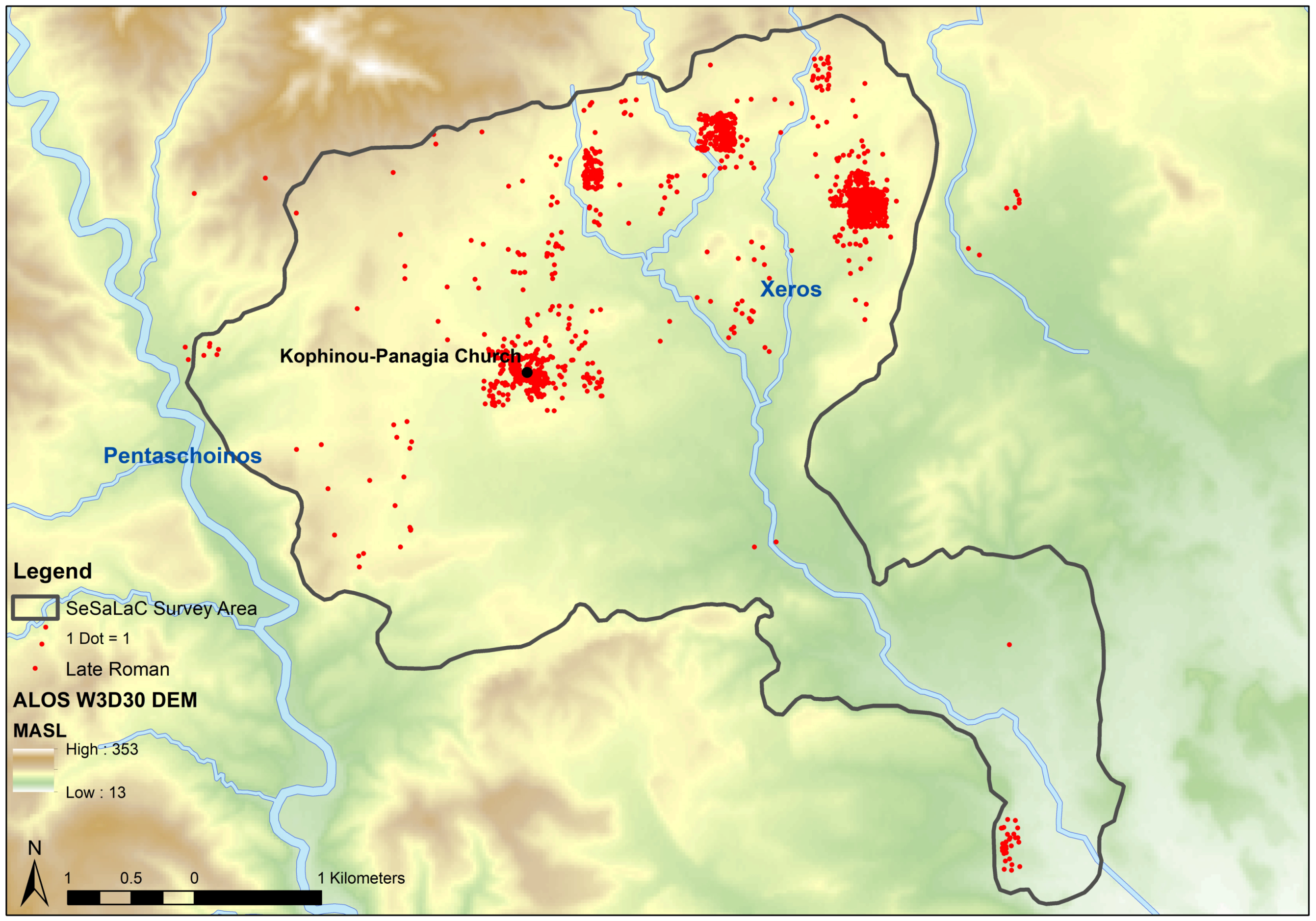
- Vionis, A.K. Settled and sacred landscapes of Cyprus: The relationship of church and landscape in Byzantine Kofinou. In Church Building in Cyprus (4th to 7th Centuries): A Mirror of Intercultural Contacts in the Eastern Mediterranean; Schriften des Instituts für Interdiziplinäre Zypern-Studien 12; Rogge, S., Nicolaou, D., Horster, M., Eds.; Waxmann: Münster, Germany, 2016; pp. 45–70. ISBN 3830937911. [Google Scholar]
- Vionis, A.K.; Papantoniou, G. Sacred landscapes as economic central places in Late Antique Naxos and Cyprus. Antiq. Tardive 2017, 25, 263–286. [Google Scholar] [CrossRef]
- Hadjisavvas, S. Olive Oil Processing in Cyprus from the Bronze Age to the Byzantine Period; Studies in Mediterranean Archaeology 99; Paul Åströms Förlag: Nicosia, Cyprus, 1992; ISBN 9170810338. [Google Scholar]
- Hadjisavvas, S. The economy of the olive. In The Development of the Cypriot Economy. From the Prehistoric Period to the Present Day; Karageorghis, V., Michaelides, D., Eds.; The A.G. Leventis Foundation/Bank of Cyprus: Nicosia, Cyprus, 1996; pp. 127–138. ISBN 9963-607-10-1. [Google Scholar]
- Vionis, A.K.; Papantoniou, G. Economic landscapes and transformed mindscapes in Cyprus from Roman times to the Early Middle Ages. In Change and Resilience: The Occupation of Mediterranean Islands in Late Antiquity; Cau Ontiveros, M.A., Mas Florit, C., Eds.; Oxbow: Oxford, UK, in press.
- Knitter, D. Central Places and the Environment. Investigations of an Interdependent Relationship. Ph.D. Thesis, Free University, Berlin, Germany, 2013. [Google Scholar]
- Iacovou, M. Political economies and landscape transformations: The case of ancient Paphos. In Structure, Measurement, and Meaning: Studies on Prehistoric Cyprus in Honour of David Frankel; Studies in Mediterranean Archaeology 143; Webb, J.M., Ed.; Paul Åströms Forlag: Uppsala, Sweden, 2014; pp. 161–174. ISBN 978-91-981535-1-4. [Google Scholar]
- Kearns, C. Re-survey and spatial analysis of landscape developments during the first millennium BC on Cyprus. Antiquity 2016, 90, 353. [Google Scholar] [CrossRef]
- Casarott, A.; Pelgrom, J.; Stek, T.D. A systematic GIS-based analysis of settlement developments in the landscape of Venusia in the Hellenistic-Roman period. Archaeol. Anthropol. Sci. 2017. [Google Scholar] [CrossRef]
- Given, M. The precarious conviviality of water mills. Archaeol. Dialogues 2018, 25, 71–94. [Google Scholar] [CrossRef]


© 2018 by the authors. Licensee MDPI, Basel, Switzerland. This article is an open access article distributed under the terms and conditions of the Creative Commons Attribution (CC BY) license (http://creativecommons.org/licenses/by/4.0/).
Share and Cite
Papantoniou, G.; Vionis, A.K. The River as an Economic Asset: Settlement and Society in the Xeros Valley in Cyprus. Land 2018, 7, 157. https://doi.org/10.3390/land7040157
Papantoniou G, Vionis AK. The River as an Economic Asset: Settlement and Society in the Xeros Valley in Cyprus. Land. 2018; 7(4):157. https://doi.org/10.3390/land7040157
Chicago/Turabian StylePapantoniou, Giorgos, and Athanasios K. Vionis. 2018. "The River as an Economic Asset: Settlement and Society in the Xeros Valley in Cyprus" Land 7, no. 4: 157. https://doi.org/10.3390/land7040157
APA StylePapantoniou, G., & Vionis, A. K. (2018). The River as an Economic Asset: Settlement and Society in the Xeros Valley in Cyprus. Land, 7(4), 157. https://doi.org/10.3390/land7040157