Physical and Anthropogenic Factors Related to Landslide Activity in the Northern Peloponnese, Greece


 ,
, 
 and
and
Abstract
:
1. Introduction
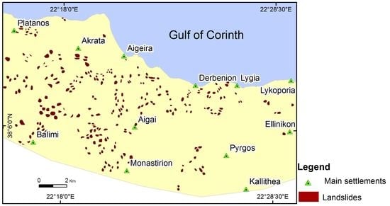
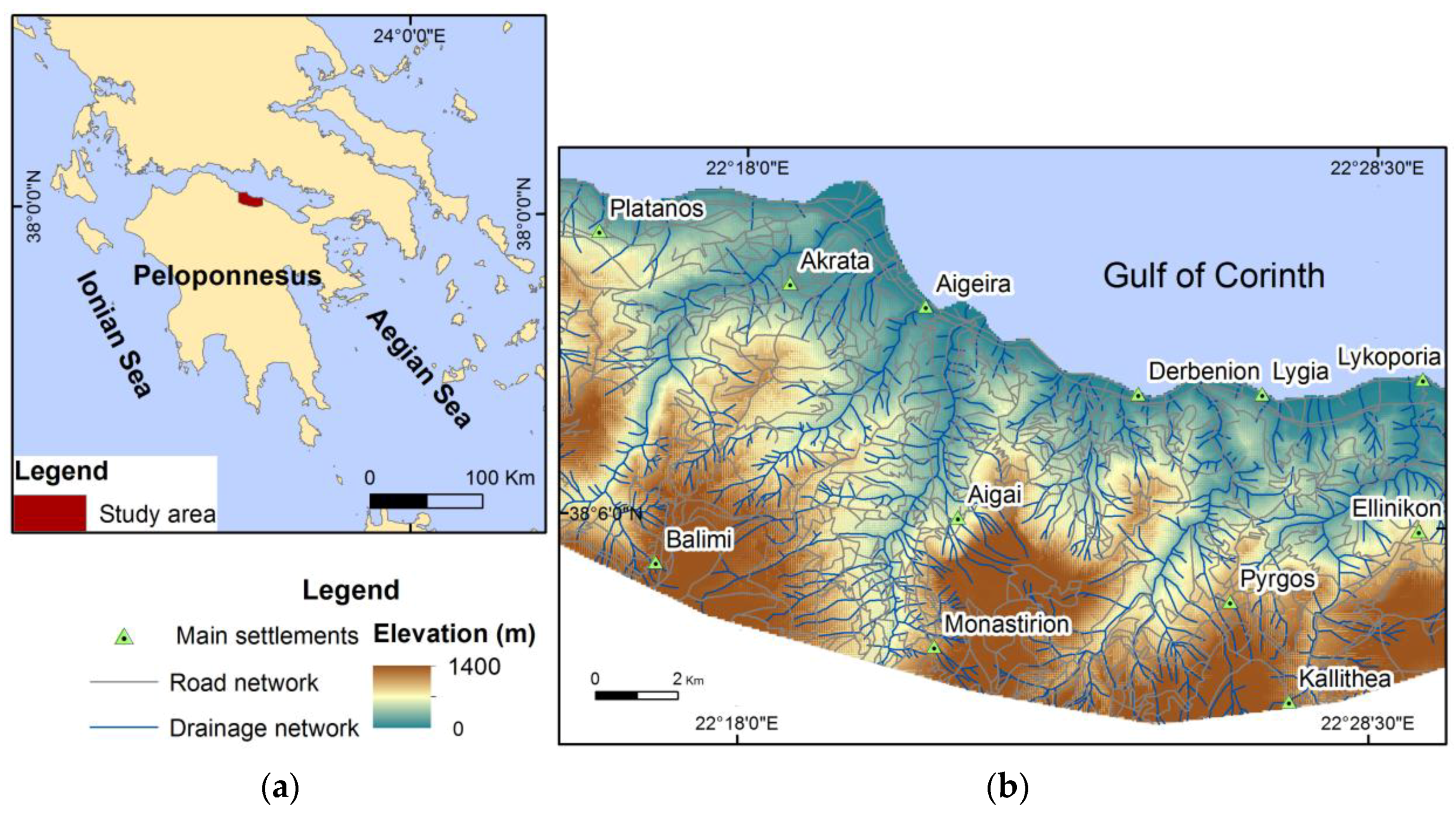
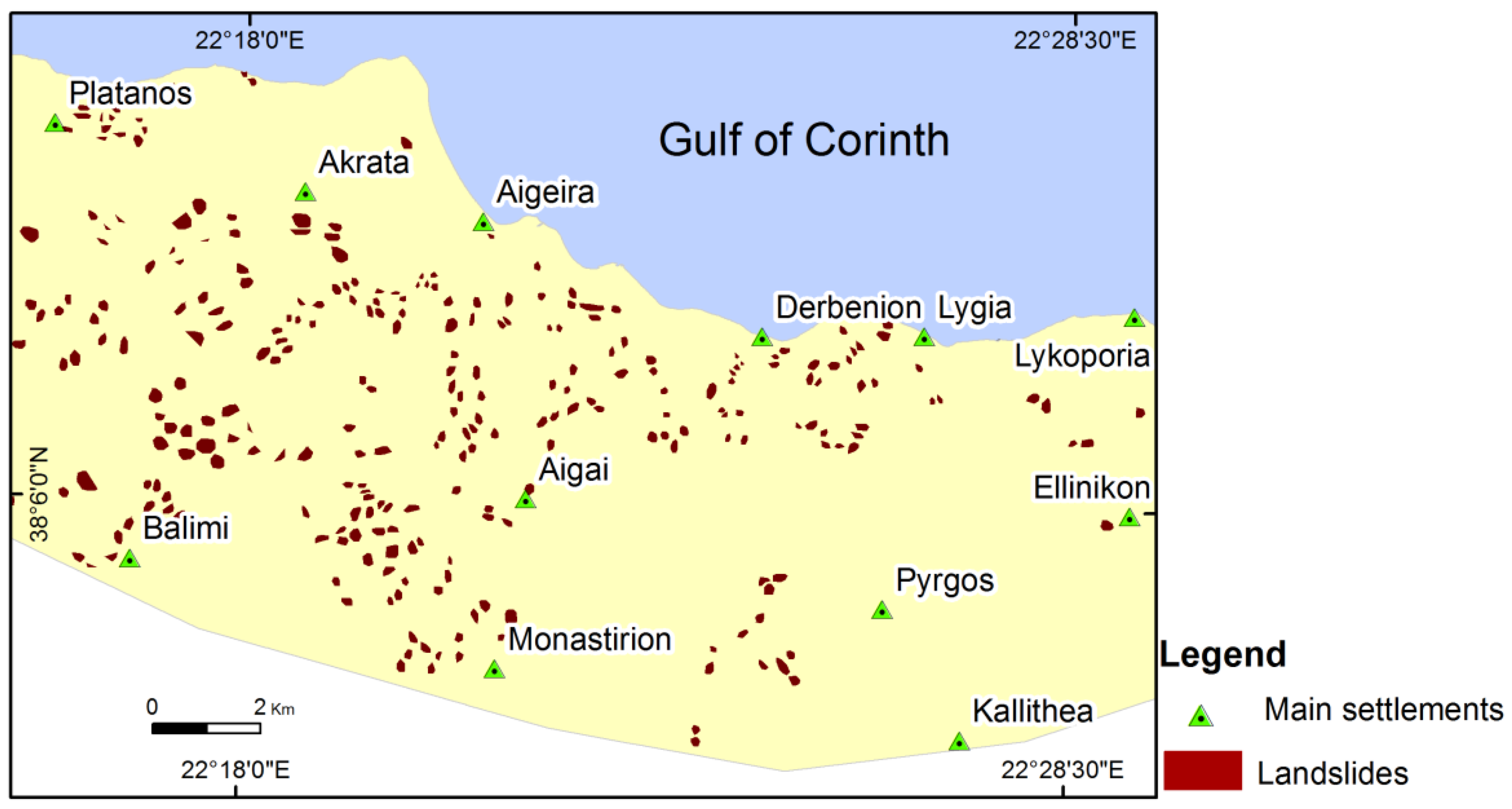
2. Study Area
3. Materials and Methods
- a topographic map (1:50,000 scale) from the Hellenic Military Geographical Service (HAGS);
- a satellite image via Google Earth, Landsat 7/Copernicus, with an acquisition date of July 2015;
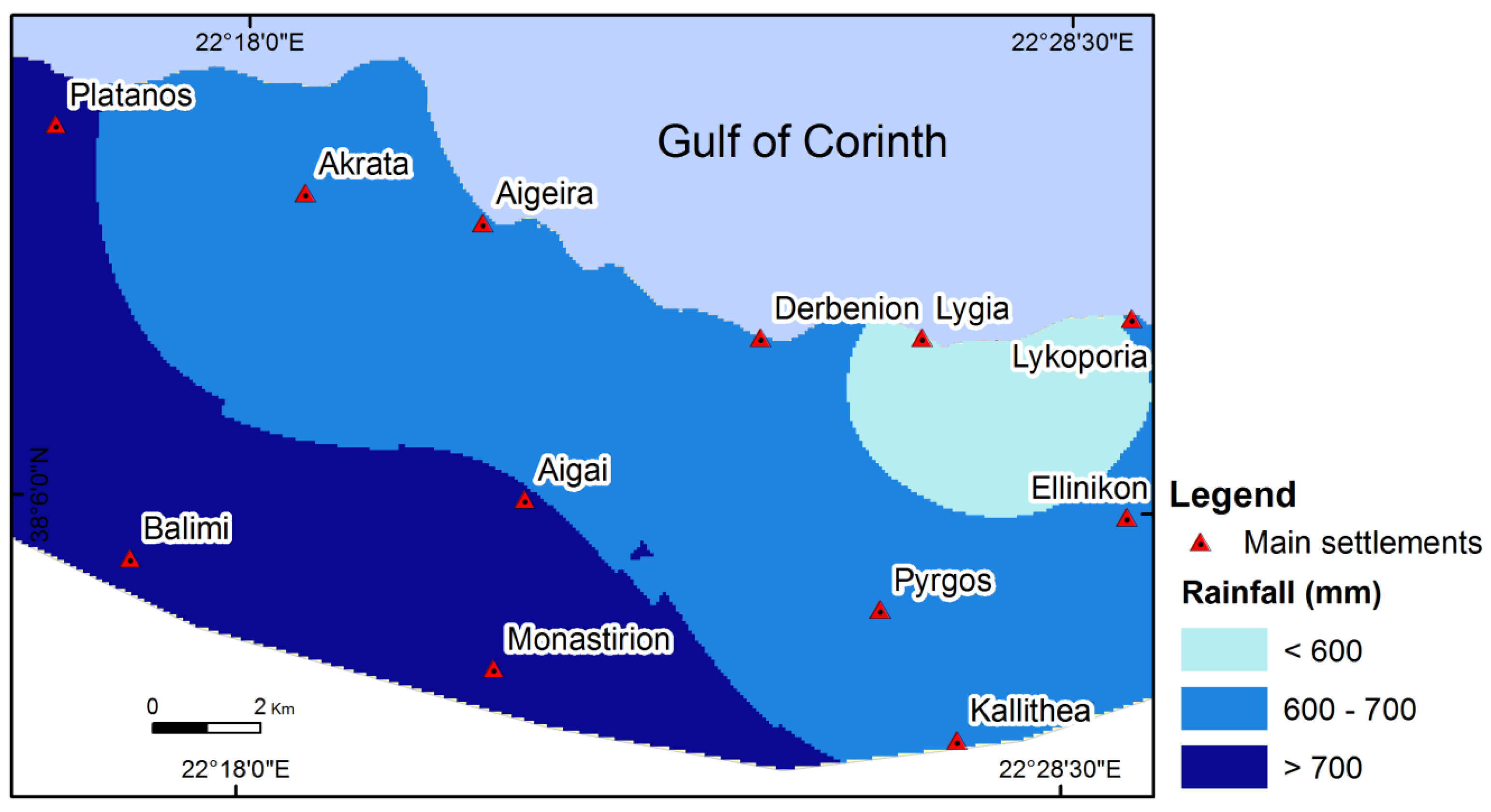
- rainfall records from six stations, belonging to: (a) the Hellenic National Meteorological Service; (b) the Ministry for the Environment, Physical Planning and Public Works; and (c) the Ministry of Agriculture and Ministry of Development. These records referred to mean annual precipitation for the period of 1975–2010;
- field work data involving observations on landslide sites.
3.1. Landslide Inventory Map
3.2. Physical and Anthropogenic Factors
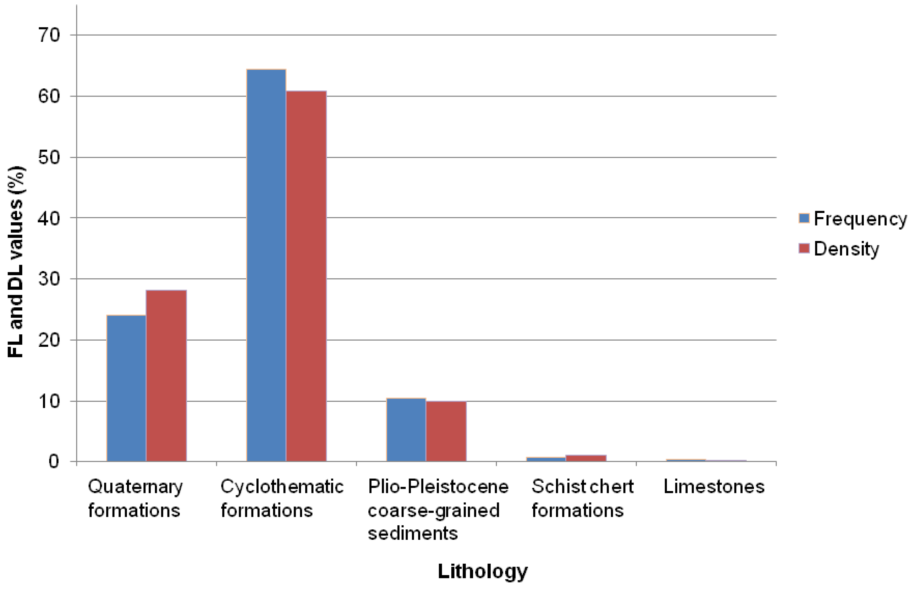
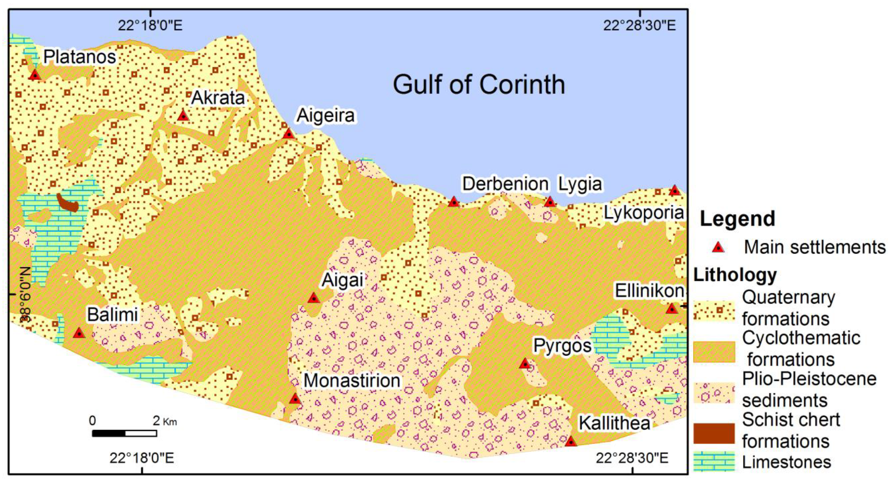
3.2.1. Lithology
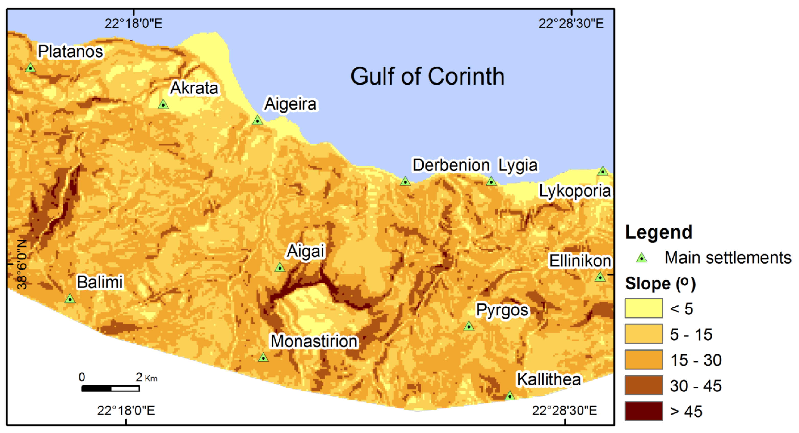
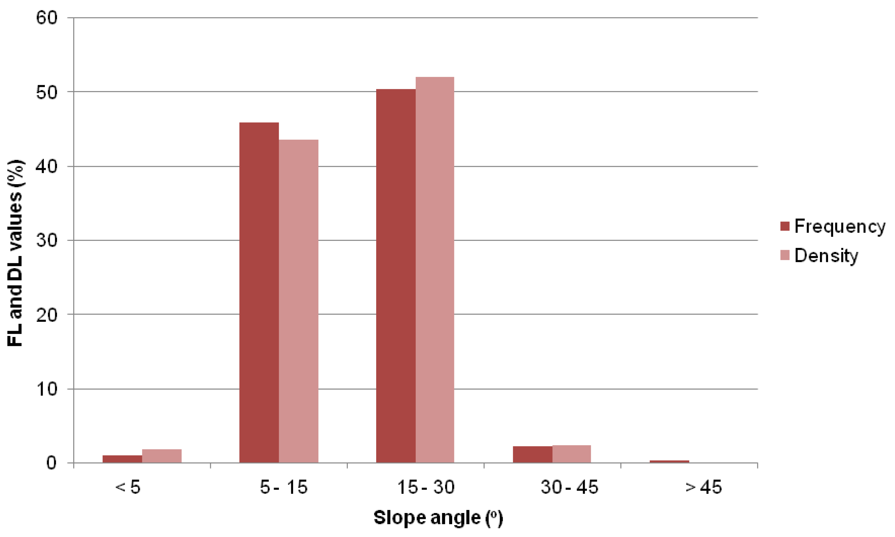
3.2.2. Slope Angle
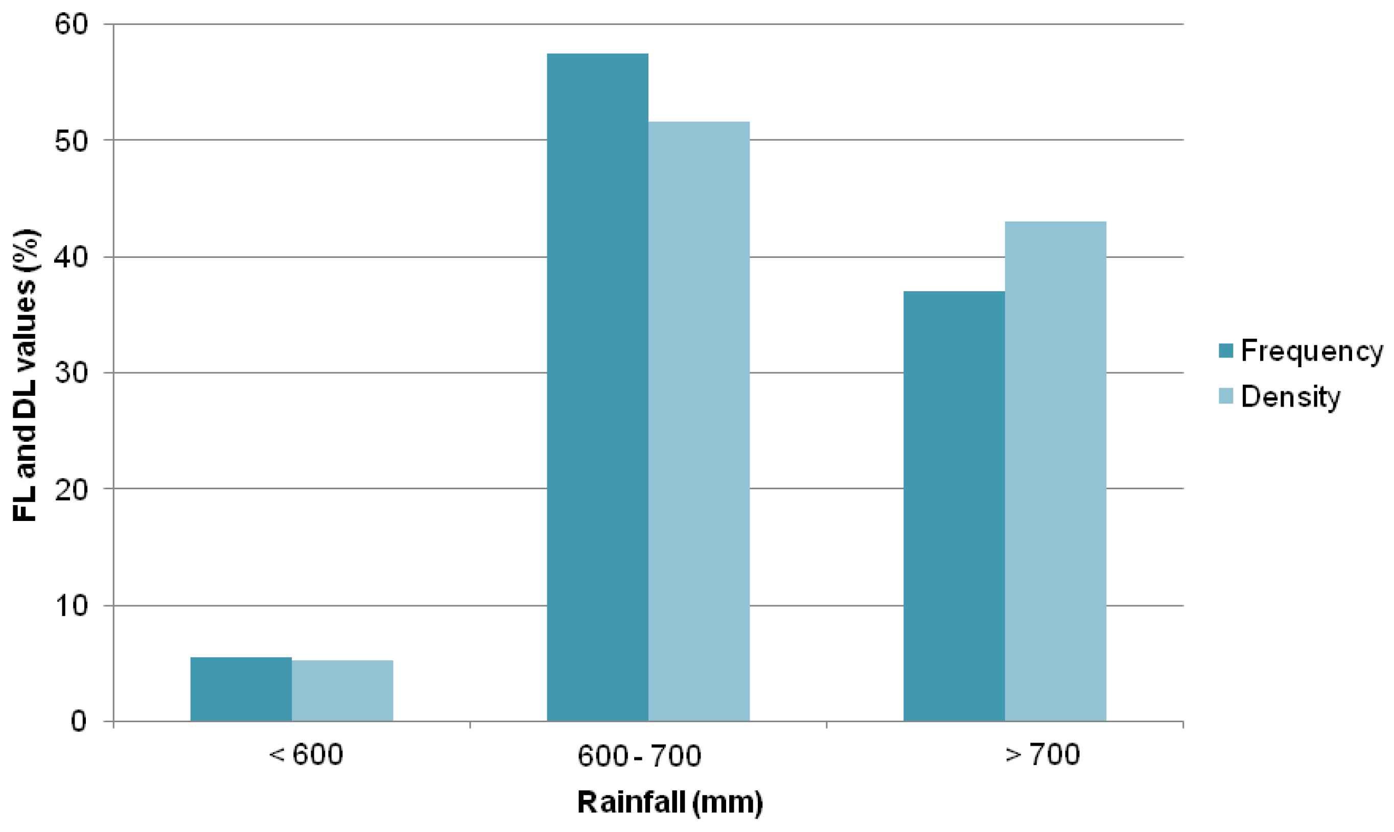
3.2.3. Rainfall
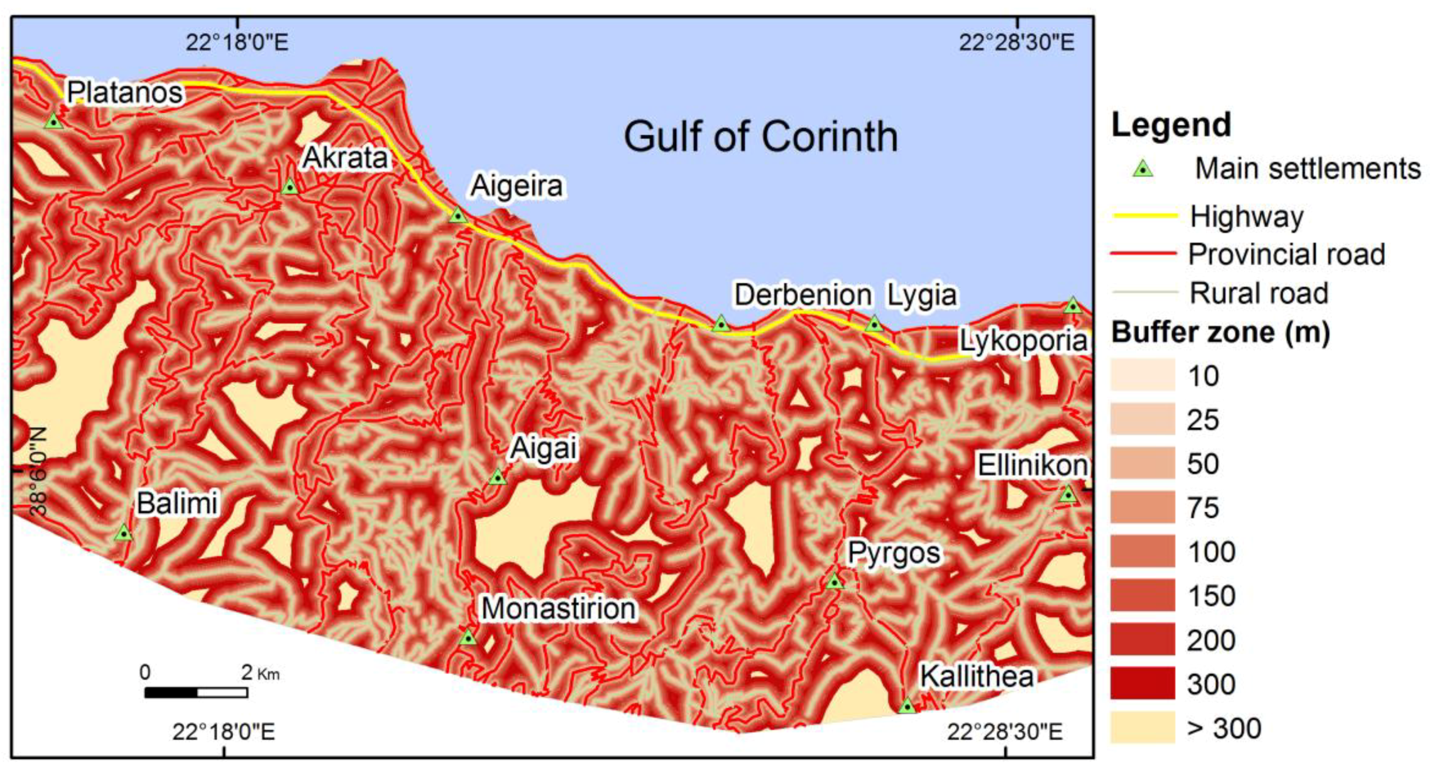
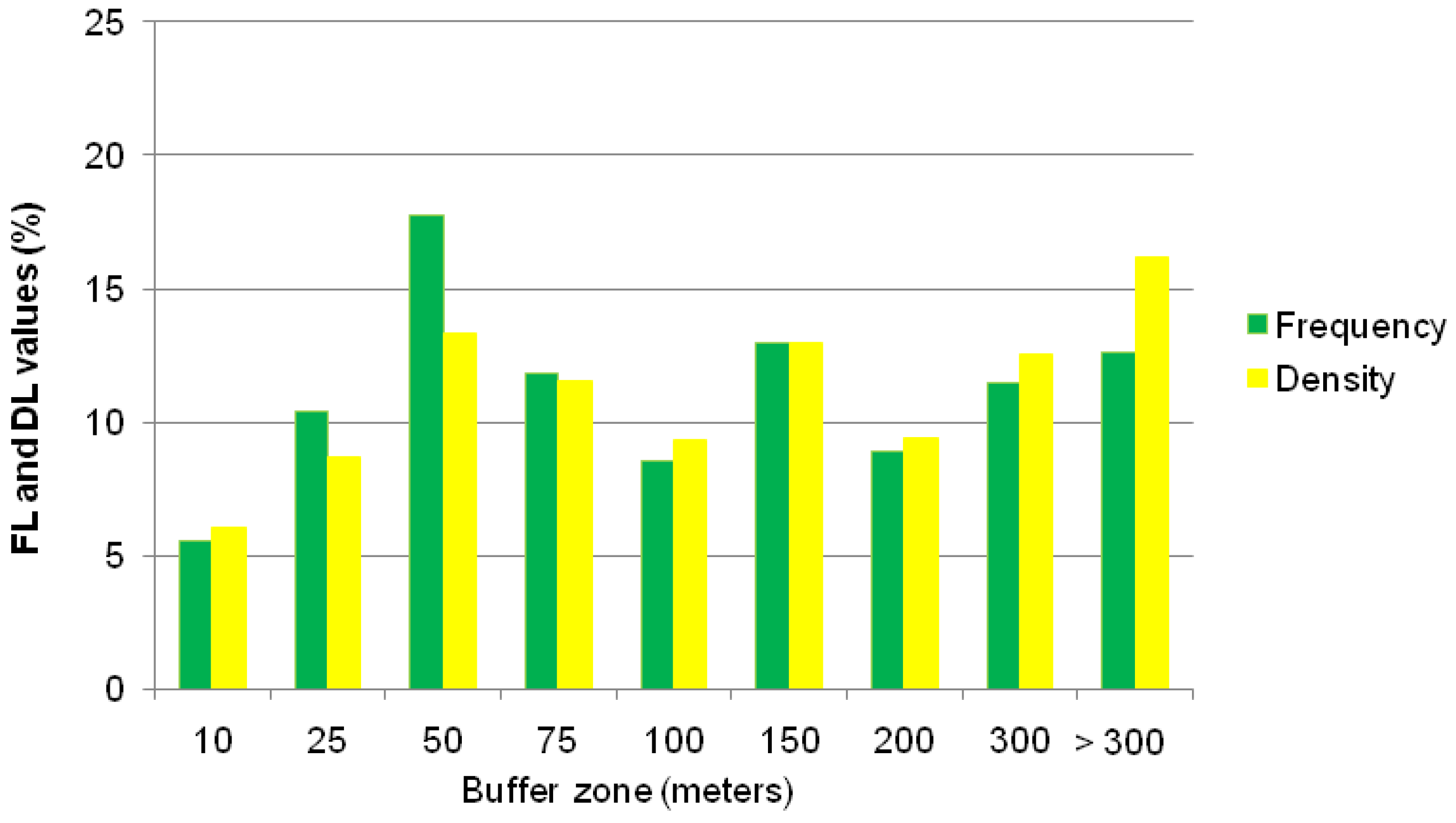
3.2.4. Road Network
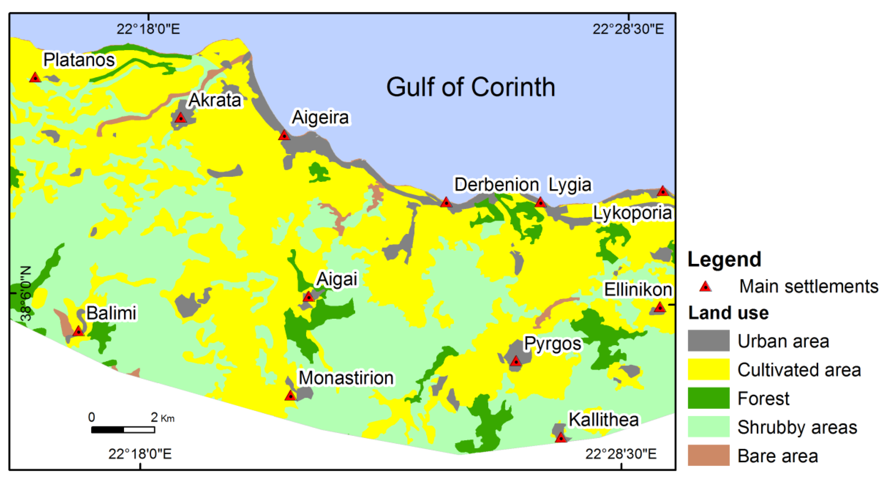
3.2.5. Land Use
4. Results
5. Discussion
6. Conclusions
Author Contributions
Funding
Conflicts of Interest
References
- Bathrellos, G.D.; Skilodimou, H.D.; Chousianitis, K.; Youssef, A.M.; Pradhan, B. Suitability estimation for urban development using multi-hazard assessment map. Sci. Total Environ. 2017, 575, 119–134. [Google Scholar] [CrossRef] [PubMed]
- Cruden, D.M. A simple definition of a landslide. Bull. Eng. Geol. Environ. 1991, 43, 27–29. [Google Scholar] [CrossRef]
- Varnes, D.J. Slope movement types and processes. In Landslides, Analysis and Control; Schuster, R.L., Krizek, R.J., Eds.; Transportation Research Board, Special Report 176; National Research Council: Washington, DC, USA, 1978; pp. 12–33. [Google Scholar]
- Chousianitis, K.; Del Gaudio, V.; Sabatakakis, N.; Kavoura, K.; Drakatos, G.; Bathrellos, G.D.; Skilodimou, H.D. Assessment of Earthquake-Induced Landslide Hazard in Greece: From Arias Intensity to Spatial Distribution of Slope Resistance Demand. Bull. Seismol. Soc. Am. 2016, 106, 174–188. [Google Scholar] [CrossRef]
- Rozos, D.; Skilodimou, H.D.; Loupasakis, C.; Bathrellos, G.D. Application of the revised universal soil loss equation model on landslide prevention. An example from N. Euboea (Evia) Island, Greece. Environ. Earth Sci. 2013, 70, 3255–3266. [Google Scholar] [CrossRef]
- Bathrellos, G.D.; Skilodimou, H.D.; Maroukian, H.; Gaki-Papanastassiou, K.; Kouli, K.; Tsourou, T.; Tsaparas, N. Pleistocene glacial and lacustrine activity in the southern part of Mount Olympus (Central Greece). Area 2017, 49, 137–147. [Google Scholar] [CrossRef]
- Skilodimou, H.D.; Bathrellos, G.D.; Maroukian, H.; Gaki-Papanastassiou, K. Late Quaternary evolution of the lower reaches of Ziliana stream in south Mt. Olympus (Greece). Geogr. Fis. Din. Quat. 2014, 37, 43–50. [Google Scholar] [CrossRef]
- Kamberis, E.; Bathrellos, G.; Kokinou, E.; Skilodimou, H. Correlation between the structural pattern and the development of the hydrographic network in a portion of the Western Thessaly basin (Greece). Cent. Eur. J. Geosci. 2012, 4, 416–424. [Google Scholar] [CrossRef]
- Kokinou, E.; Skilodimou, H.D.; Bathrellos, G.D.; Antonarakou, A.; Kamberis, E. Morphotectonic analysis, structural evolution/pattern of a contractional ridge: Giouchtas Mt., Central Crete, Greece. J. Earth Syst. Sci. 2015, 124, 587–602. [Google Scholar] [CrossRef]
- Sidle, R.C.; Pearce, A.J.; O’Loughlin, C.L. Hillslope Stability and Land Use; American Geophysical Union Water Resources Monograph Series; AGU Publications: Washington, DC, USA, 1985; p. 140. ISBN 9781118665503. [Google Scholar]
- Dai, F.C.; Lee, C.F.; Ngai, Y.Y. Landslide risk assessment and management: An overview. Eng. Geol. 2002, 64, 65–87. [Google Scholar] [CrossRef]
- Kumar, K.; Jangpangi, L.; Gangopadhyay, S. Highway vs. landslides and their consequences in Himalaya. In Landslide Science for a Safer Geoenvironment; Sassa, K., Canuti, P., Yin, Y., Eds.; Springer: Berlin/Heidelberg, Germany, 2014; pp. 389–395. [Google Scholar]
- Schuster, R.L.; Fleming, R.W. Economic losses and fatalities due to landslides. Environ. Eng. Geosci. 1986, xxiii, 11–28. [Google Scholar] [CrossRef]
- Guzzetti, F. Landslide fatalities and the evaluation of landslide risk in Italy. Eng. Geol. 2000, 58, 89–107. [Google Scholar] [CrossRef]
- Sabatakakis, N.; Koukis, G.; Mourtas, D. Composite landslides induced by heavy rainfall in suburban areas. City of Patras and surrounding area, Western Greece. Landslides 2005, 2, 202–211. [Google Scholar] [CrossRef]
- Bathrellos, G.D.; Gaki-Papanastassiou, K.; Skilodimou, H.D.; Papanastassiou, D.; Chousianitis, K.G. Potential suitability for urban planning and industry development by using natural hazard maps and geological-geomorphological parameters. Environ. Earth Sci. 2012, 66, 537–548. [Google Scholar] [CrossRef]
- Bathrellos, G.D.; Gaki-Papanastassiou, K.; Skilodimou, H.D.; Skianis, G.A.; Chousianitis, K.G. Assessment of rural community and agricultural development using geomorphological-geological factors and GIS in the Trikala prefecture (Central Greece). Stoch. Environ. Res. Risk A 2013, 27, 573–588. [Google Scholar] [CrossRef]
- Larsen, M.C.; Parks, J.E. How wide is a road? The association of roads and mass-wasting in a forested montane environment. Earth Surf. Proc. Land. 1997, 22, 835–848. [Google Scholar] [CrossRef]
- Bozzano, F.; Cipriani, I.; Mazzanti, P.; Prestininzi, A. Displacement patterns of a landslide affected by human activities: Insights from ground-based InSAR monitoring. Nat. Hazards 2011, 59, 1377–1396. [Google Scholar] [CrossRef]
- Bathrellos, G.D.; Kalivas, D.P.; Skilodimou, H.D. Landslide Susceptibility Assessment Mapping: A Case Study in Central Greece. In Remote Sensing of Hydrometeorological Hazards; Petropoulos, G.P., Islam, T., Eds.; CRC Press; Taylor & Francis Group: London, UK, 2017; pp. 493–512, ISBN-13 978-1498777582. [Google Scholar]
- Papadopoulou-Vrynioti, K.; Bathrellos, G.D.; Skilodimou, H.D.; Kaviris, G.; Makropoulos, K. Karst collapse susceptibility mapping considering peak ground acceleration in a rapidly growing urban area. Eng. Geol. 2013, 158, 77–88. [Google Scholar] [CrossRef]
- Papadopoulou-Vrynioti, K.; Alexakis, D.; Bathrellos, G.D.; Skilodimou, H.D.; Vryniotis, D.; Vasiliades, E. Environmental research and evaluation of agricultural soil of the Arta plain, western Hellas. J. Geochem. Explor. 2014, 136, 84–92. [Google Scholar] [CrossRef]
- Papadopoulou-Vrynioti, K.; Alexakis, D.; Bathrellos, G.D.; Skilodimou, H.D.; Vryniotis, D.; Vasiliades, E.; Gamvroula, D. Distribution of trace elements in stream sediments of Arta plain (Western Hellas): The influence of geomorphological parameters. J. Geochem. Explor. 2013, 134, 17–26. [Google Scholar] [CrossRef]
- Youssef, A.M.; Pradhan, B.; Al-Kathery, M.; Bathrellos, G.D.; Skilodimou, H.D. Assessment of rockfall hazard at Al-Noor Mountain, Makkah city (Saudi Arabia) using spatio-temporal remote sensing data and field investigation. J. Afr. Earth Sci. 2015, 101, 309–321. [Google Scholar] [CrossRef]
- Lu, P.; Stumpf, A.; Kerle, N. Object-oriented change detection for landslide rapid mapping. IEEE Geosci. Remote Sens. Lett. 2011, 8, 701–705. [Google Scholar] [CrossRef]
- Bathrellos, G.D.; Skilodimou, H.D.; Maroukian, H. The spatial distribution of Middle and Late Pleistocene Cirques in Greece. Geogr. Ann. 2014, 96, 323–338. [Google Scholar] [CrossRef]
- Bathrellos, G.D.; Skilodimou, H.D.; Maroukian, H. The significance of tectonism in the glaciations of Greece. In Quaternary Glaciation in the Mediterranean Mountains; Hughes, P.D., Woodward, J.C., Eds.; Geological Society London Special Publications: London, UK, 2017; pp. 237–250. [Google Scholar] [CrossRef]
- Youssef, A.M.; Pradhan, B.; Tarabees, E. Integrated evaluation of urban development suitability based on remote sensing and GIS techniques: Contribution from analytic hierarchy process. Arab. J. Geosci. 2011, 4, 463–473. [Google Scholar] [CrossRef]
- Bathrellos, G.D.; Karymbalis, E.; Skilodimou, H.D.; Gaki-Papanastassiou, K.; Baltas, E.A. Urban flood hazard assessment in the basin of Athens Metropolitan city, Greece. Environ. Earth Sci. 2016, 75, 319. [Google Scholar] [CrossRef]
- Van Westen, C.J. Remote sensing and GIS for natural hazards assessment and disaster risk management. In Treatise on Geomorphology; Schroder, J.F., Bishop, M.P., Eds.; Academic Press; Elsevier: New York, NY, USA, 2013; pp. 259–298. [Google Scholar]
- Armijo, R.; Meyer, B.; King, G.; Rigo, A.; Papanastassiou, D. Quaternary evolution of the Corinth Rift and its implications for the late Cenozoic evolution of the Aegean. Geophys. J. Int. 1996, 126, 11–53. [Google Scholar] [CrossRef]
- Koukis, G.; Rozos, D. Geotechnical conditions and landslide movements in the Greek territory in relation to the geological structure and geotectonic evolution. Miner. Wealth 1982, 16, 53–69. [Google Scholar]
- Rozos, D.; Bathrellos, G.D.; Skilodimou, H.D. Comparison of the implementation of Rock Engineering System (RES) and Analytic Hierarchy Process (AHP) methods, based on landslide susceptibility maps, compiled in GIS environment. A case study from the Eastern Achaia County of Peloponnesus, Greece. Environ. Earth Sci. 2011, 63, 49–63. [Google Scholar] [CrossRef]
- Yilmaz, I. The effect of the sampling strategies on the landslide susceptibility mapping by conditional probability and artificial neural networks. Environ. Earth Sci. 2010, 60, 505–519. [Google Scholar] [CrossRef]
- Bathrellos, G.D.; Kalivas, D.P.; Skilodimou, H.D. Landslide susceptibility mapping models, applied to natural and urban planning, using G.I.S. Estud. Geol.-Madrid 2009, 65, 49–65. [Google Scholar] [CrossRef]
- Lee, S.; Pradhan, B. Probabilistic landslide hazards and risk mapping on Penang Island, Malaysia. J. Earth Syst. Sci. 2006, 115, 661–672. [Google Scholar] [CrossRef]
- Τsolaki-Fiaka, S.; Bathrellos, G.D.; Skilodimou, H.D. Multi-criteria decision analysis for abandoned quarry restoration in Evros Region (NE Greece). Land 2018, 7, 43. [Google Scholar] [CrossRef]
- Migiros, G.; Bathrellos, G.; Skilodimou, H.; Karamousalis, T. Pinios (Peneus) River (Central Greece): Hydrological-geomorphological elements and changes during the quaternary. Cent. Eur. J. Geosci. 2011, 3, 215–228. [Google Scholar] [CrossRef]
- Donati, L.; Turrini, M.C. An objective method to rank the importance of the factors predisposing to landslides with the GIS methodology: Application to an area of the Apennines (Valnerina; Perugia, Italy). Eng. Geol. 2002, 63, 277–289. [Google Scholar] [CrossRef]
- Ayalew, L.; Yamagishi, H.; Ugawa, N. Landslide susceptibility mapping using GIS-based weighted linear combination, the case in Tsugawa area of Agano River, Niigata Prefecture, Japan. Landslides 2004, 1, 73–81. [Google Scholar] [CrossRef]
- Cristiano, E.; Veldhuis, M.C.T.; Giesen, N.V.D. Spatial and temporal variability of rainfall and their effects on hydrological response in urban areas—A review. Hydrol. Earth Syst. Sci. 2017, 21, 3859–3878. [Google Scholar] [CrossRef]
- Copernicus. Copernicus Land Monitoring Service. 2016. Available online: http://land.copernicus.eu (accessed on 31 May 2018).


| Lithology | A (m2) | AC (%) | Ln | FL (%) | FR | La | DL (%) | DR |
|---|---|---|---|---|---|---|---|---|
| Quaternary formations | 53,096,725 | 27 | 65 | 24 | 0.9 | 1,825,615 | 28 | 1.0 |
| Cyclothematic formations | 85,865,022 | 44 | 174 | 64 | 1.5 | 3,942,500 | 61 | 1.4 |
| Plio-Pleistocene coarse-grained sediments | 46,210,814 | 24 | 28 | 10 | 0.4 | 638,169 | 10 | 0.4 |
| Schist chert formations | 202,998 | 0.1 | 2 | 1 | 7.1 | 66,758 | 1 | 9.8 |
| Limestones | 8,754,203 | 5 | 1 | 0 | 0.1 | 10,947 | 0 | 0.0 |
| Total | 194,129,763 | 100 | 270 | 100 | 1.0 | 6,483,988 | 100 | 1.0 |
| Slope angle (°) | ||||||||
| <5 | 14,298,664 | 7 | 3 | 1 | 0.2 | 125,782 | 2 | 0.3 |
| 5–15 | 71,833,677 | 37 | 124 | 46 | 1.2 | 2,827,163 | 44 | 1.2 |
| 15–30 | 90,318,029 | 47 | 136 | 50 | 1.1 | 3,369,873 | 52 | 1.1 |
| 30–45 | 16,176,882 | 8 | 6 | 2 | 0.3 | 154,197 | 2 | 0.3 |
| >45 | 1,502,511 | 1 | 1 | 0 | 0.5 | 6974 | 0 | 0.1 |
| Total | 194,129,763 | 100 | 270 | 100 | 1.0 | 6,483,988 | 100 | 1.0 |
| Rainfall (mm) | ||||||||
| <600 | 16,282,886 | 8 | 15 | 6 | 0.7 | 340,982 | 5 | 0.6 |
| 600–700 | 112,873,296 | 58 | 155 | 57 | 1.0 | 3,349,098 | 52 | 0.9 |
| >700 | 64,973,582 | 33 | 100 | 37 | 1.1 | 2,793,907 | 43 | 1.3 |
| Total | 194,129,763 | 100 | 270 | 100 | 1.0 | 6,483,988 | 100 | 1.0 |
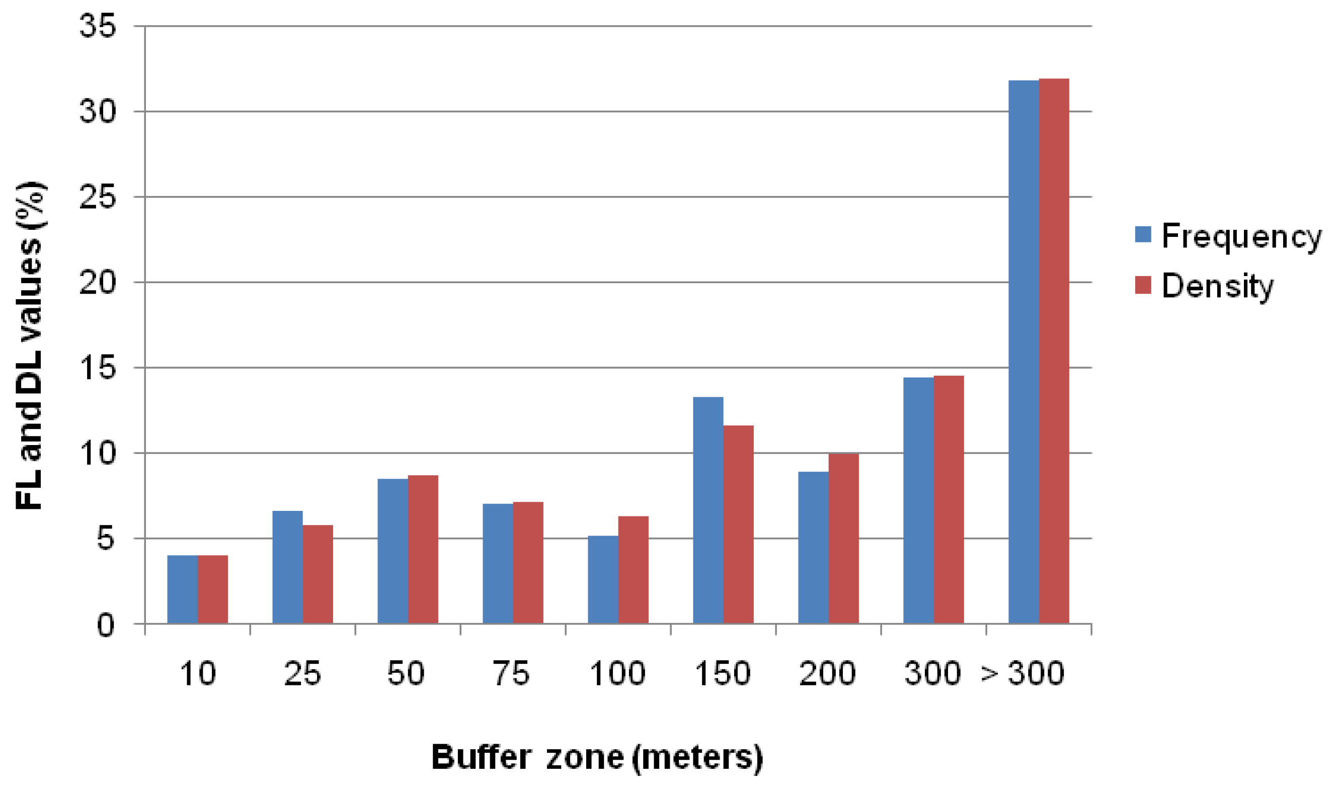
| Highway and provincial roads network buffer zone (m) | ||||||||
| 10 | 6,830,803 | 4 | 11 | 4 | 1.2 | 260,301 | 4 | 1.1 |
| 25 | 9,878,673 | 5 | 18 | 7 | 1.3 | 373,996 | 6 | 1.1 |
| 50 | 15,147,727 | 8 | 23 | 9 | 1.1 | 562,552 | 9 | 1.2 |
| 75 | 13,257,597 | 7 | 19 | 7 | 1.0 | 462,461 | 7 | 1.1 |
| 100 | 11,550,219 | 6 | 14 | 5 | 0.9 | 408,156 | 6 | 0.9 |
| 150 | 19,325,306 | 10 | 36 | 13 | 1.3 | 752,079 | 12 | 1.2 |
| 200 | 15,830,201 | 8 | 24 | 9 | 1.1 | 647,413 | 10 | 1.2 |
| 300 | 24,566,099 | 13 | 39 | 14 | 1.1 | 945,164 | 15 | 1.2 |
| >300 | 77,743,138 | 40 | 86 | 32 | 0.8 | 2,071,866 | 32 | 0.8 |
| Total | 194,129,763 | 100 | 270 | 100 | 1.0 | 6,483,988 | 100 | 1.0 |
| Rural roads network buffer zone (m) | ||||||||
| 10 | 7,728,922 | 4 | 15 | 6 | 1.4 | 392,238 | 6 | 1.5 |
| 25 | 11,367,074 | 6 | 28 | 10 | 1.8 | 563,374 | 9 | 1.5 |
| 50 | 18,040,789 | 9 | 48 | 18 | 1.9 | 866,394 | 13 | 1.4 |
| 75 | 16,592,806 | 9 | 32 | 12 | 1.4 | 746,290 | 12 | 1.3 |
| 100 | 15,128,865 | 8 | 23 | 9 | 1.1 | 605,058 | 9 | 1.2 |
| 150 | 26,430,630 | 14 | 35 | 13 | 0.9 | 838,841 | 13 | 0.9 |
| 200 | 21,657,810 | 11 | 24 | 9 | 0.8 | 610,802 | 9 | 0.8 |
| 300 | 30,320,688 | 16 | 31 | 11 | 0.7 | 812,673 | 13 | 0.8 |
| >300 | 46,862,180 | 24 | 34 | 13 | 0.5 | 1,048,317 | 16 | 0.7 |
| Total | 194,129,763 | 100 | 270 | 100 | 1.0 | 6,483,988 | 100 | 1.0 |
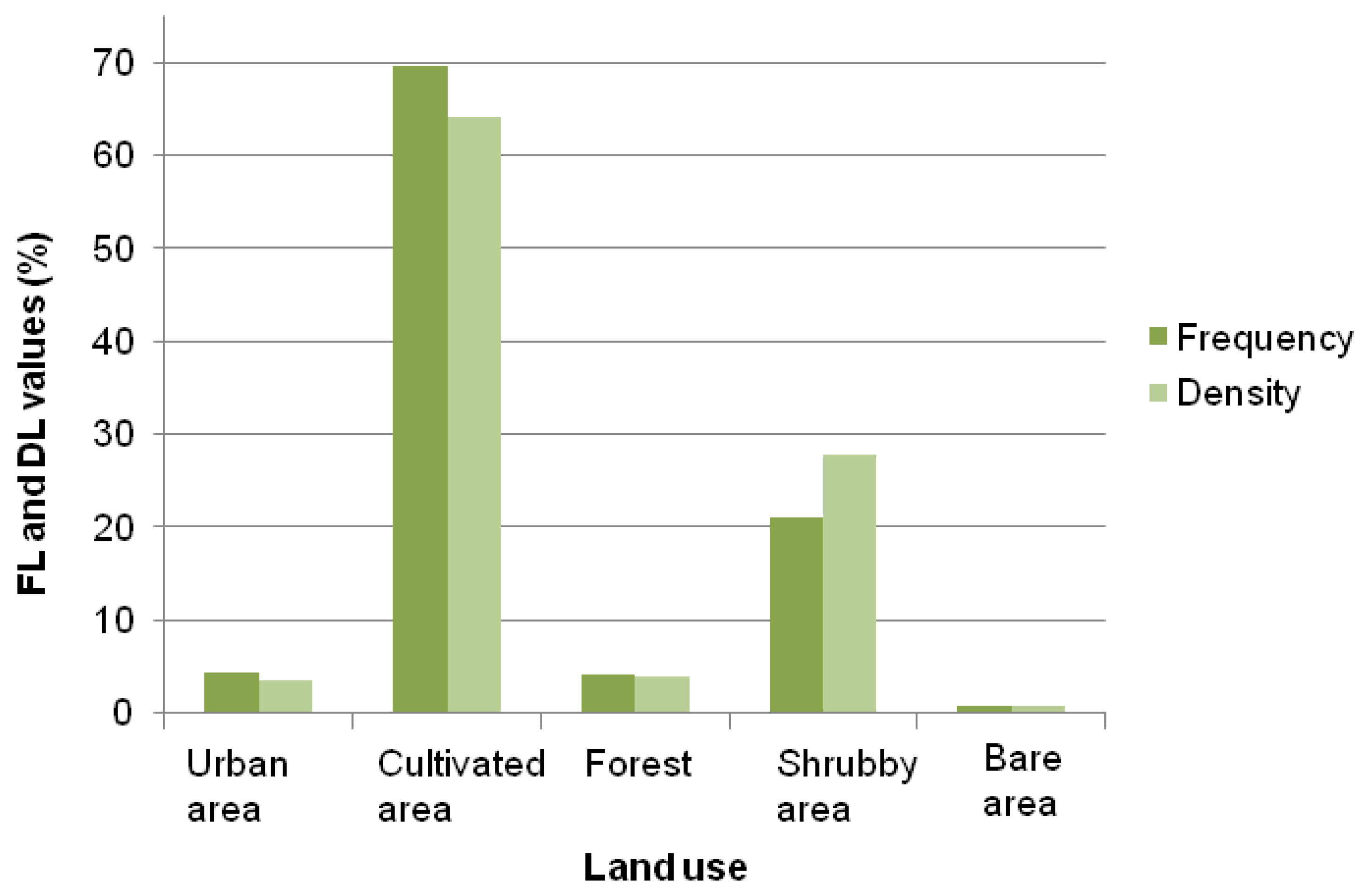
| Land use | ||||||||
| Urban area | 10,361,680 | 5 | 12 | 4 | 0.8 | 228,739 | 4 | 0.7 |
| Cultivated area | 89,597,161 | 46 | 188 | 70 | 1.5 | 4,158,855 | 64 | 1.4 |
| Forest | 11,307,988 | 6 | 11 | 4 | 0.7 | 249,236 | 4 | 0.7 |
| Shrubby area | 80,742,318 | 42 | 57 | 21 | 0.5 | 1,800,696 | 28 | 0.7 |
| Bare area | 2,120,616 | 1 | 2 | 1 | 0.7 | 46,461 | 1 | 0.7 |
| Total | 194,129,763 | 100 | 270 | 100 | 1.0 | 6,483,988 | 100 | 1.0 |
© 2018 by the authors. Licensee MDPI, Basel, Switzerland. This article is an open access article distributed under the terms and conditions of the Creative Commons Attribution (CC BY) license (http://creativecommons.org/licenses/by/4.0/).
Share and Cite
Skilodimou, H.D.; Bathrellos, G.D.; Koskeridou, E.; Soukis, K.; Rozos, D. Physical and Anthropogenic Factors Related to Landslide Activity in the Northern Peloponnese, Greece. Land 2018, 7, 85. https://doi.org/10.3390/land7030085
Skilodimou HD, Bathrellos GD, Koskeridou E, Soukis K, Rozos D. Physical and Anthropogenic Factors Related to Landslide Activity in the Northern Peloponnese, Greece. Land. 2018; 7(3):85. https://doi.org/10.3390/land7030085
Chicago/Turabian StyleSkilodimou, Hariklia D., George D. Bathrellos, Efterpi Koskeridou, Konstantinos Soukis, and Dimitrios Rozos. 2018. "Physical and Anthropogenic Factors Related to Landslide Activity in the Northern Peloponnese, Greece" Land 7, no. 3: 85. https://doi.org/10.3390/land7030085
APA StyleSkilodimou, H. D., Bathrellos, G. D., Koskeridou, E., Soukis, K., & Rozos, D. (2018). Physical and Anthropogenic Factors Related to Landslide Activity in the Northern Peloponnese, Greece. Land, 7(3), 85. https://doi.org/10.3390/land7030085