Flood Hazard Mapping of a Rapidly Urbanizing City in the Foothills (Birendranagar, Surkhet) of Nepal
Abstract
:1. Introduction
2. Method
2.1. Study Area
2.2. Extraction of LULC Change
2.3. Identification of Flood Hazards
2.4. Urban/Built-Up Area Expansion Rate
2.5. Classiifcation Accuracy Assessment
3. Result and Discussion
3.1. Land-Use Land-Cover Change between 1989 and 2016
3.2. Flood Area Analysis
4. Conclusions
Author Contributions
Acknowledgments
Conflicts of Interest
References
- UNISDR. Living with Risk: A global Review of Disasterreduction Initiatives; United Nation, Inter Agency Secretariat of the International Strategy for Disaster Reduction: Geneva, Switzerland, 2004; Volume 1. [Google Scholar]
- Zhao, M.; Cheng, W.; Zhou, C.; Li, M.; Huang, K.; Wang, N. Assessing Spatiotemporal Characteristics of Urbanization Dynamics in Southeast Asia Using Time Series of DMSP/OLS Nighttime Light Data. Remote Sens. 2018, 10, 47. [Google Scholar] [CrossRef]
- Eskandari, M.; Omidvar, B.; Modiri, M.; Nekooie, M.; Alesheikh, A. Geospatial Analysis of Earthquake Damage Probability of Water Pipelines Due to Multi-Hazard Failure. ISPRS Int. J. Geo-Inf. 2017, 6, 169. [Google Scholar] [CrossRef]
- Rimal, B.; Zhang, L.; Keshtkar, H.; Sun, X.; Rijal, S. Quantifying the Spatiotemporal Pattern of Urban Expansion and Hazard and Risk Area Identification in the Kaski District of Nepal. Land 2018, 7, 37. [Google Scholar] [CrossRef]
- Halimi, M.; Sedighifar, Z.; Mohammadi, C. Analyzing spatiotemporal land use/cover dynamic using remote sensing imagery and GIS techniques case: Kan basin of Iran. GeoJournal 2017, 1–11. [Google Scholar] [CrossRef]
- Sanyal, J.; Lu, X.X. Application of Remote Sensing in Flood Management with Special Reference to Monsoon Asia: A Review. Nat. Hazards 2004, 33, 283–301. [Google Scholar] [CrossRef]
- Dewan, A.M. Geospatial Techniques in Assessing Hazards, Risk and Vulnerability; Springer: Dordrecht, The Netherlands; Heidelberg, Germany; New York, NY, USA; London, UK, 2013. [Google Scholar]
- Guha-Sapir, D.; Hoyois, P.; Below, R. Annual Disaster Statistical Review 2014: The Numbers and Trends; Centre for Research on the Epidemiology of Disasters (CRED): Brussels, Belgium, 2015. [Google Scholar]
- Guha-Sapir, D.; Hoyois, P.; Below, R. Annual Disaster Statistical Review 2015: The Numbers and Trends; Centre for Research on the Epidemiology of Disasters (CRED): Brussels, Belgium, 2016. [Google Scholar]
- Karymbalis, E.; Katsafados, P.; Chalkias, C.; Gaki-Papanastassiou, K. An integrated study for the evaluation of natural and anthropogenic causes of flooding in small catchments based on geomorphological and meteorological data and modeling techniques: The case of the Xerias torrent (Corinth, Greece). Z. Geomorphol. 2012, 56, 45–67. [Google Scholar] [CrossRef]
- Shrestha, M. Impacts of Floods in South Asia. J. South Asia Disaster Stud. 2008, 1, 85–106. [Google Scholar]
- Upreti, B. Impact of natural disaster on development of Nepal. In Bhandary NP. Disasters and Development, Investing in Sustainable Development in Nepal; Subedi, J.K., Ed.; Ehime University, Japanand Bajra Publication: Kathmandu, Nepal, 2010. [Google Scholar]
- Ministry of Home Affairs (MoHA). Nepal Disaster Report 2011; Ministry of Home Affairs (MoHA) and Disaster Preparedance Network (DPNeT): Kathmandu, Nepal, 2011.
- United Nations Development Programme (UNDP). Global Assessment of Risk. In Nepal Countary Report; UNDP Pulchowk: Kathmandu, Nepal, 2009. [Google Scholar]
- Department of Water Induced Disaster Prevention (DWIDP). Annual Disaster Review 2012. Government of Nepal; Ministry of Irrigation Department of Water Induced Disater Management, Ed.; DWIDP: Kathmandu, Nepal, 2013.
- Ministry of Home Affairs (MoHA). Nepal Disaster Report 2015; Disaster Preparedance Network (DPNeT); Ministry of Home Affairs (MoHA): Kathmandu, Nepal, 2015.
- Kafle, K.R.; Khanal, S.N.; Dahal, R.K. Consequences of Koshi flood 2008 in terms of sedimentation characteristics and agricultural practices. Geoenviron. Disasters 2017, 4. [Google Scholar] [CrossRef]
- MoHA. Nepal Disaster Report. Available online: http;;//drrportal.gov.np (accessed on 19 November 2017).
- Dahal, R.K.; Bhandary, N.P. Geo-Disaster and Its Mitigation in Nepal. In Progress of Geo-Disaster Mitigation Technology in Asia; Springer: Berlin/Heidelberg, Germany, 2013; pp. 123–156. [Google Scholar]
- International Centre for Integrated Mountain Development/United Nation Educational Scientific and Cultural Organization (ICIMOD/UNESCO). Preparing for Flood Disaster Mapping and Assessing Hazard in the Ratu Watershed, Nepal; Nepal, K., United Nations Educational Scientific and Cultural Organization (UNESCO), Eds.; ICIMOD: New Delhi, India, 2007. [Google Scholar]
- Rimal, B.; Zhang, L.; Stork, N.; Sloan, S.; Rijal, S. Urban Expansion Occurred at the Expense of Agricultural Lands in the Tarai Region of Nepal from 1989 to 2016. Sustainability 2018, 10, 1341. [Google Scholar] [CrossRef]
- District Development Committee (DDC). District Profile, Surkhet; Government of Nepal, Ed.; DDC: Surkhet, Nepal, 2010. [Google Scholar]
- Morrison, A.; Westbrook, C.J.; Noble, B.F. A review of the flood risk management governance and resilience literature. J. Flood Risk Manag. 2017. [Google Scholar] [CrossRef]
- Central Bureau of Statistics (CBS). Population Monograph of Nepal; National Planning Commission Secretariat; CBS: Kathmandu, Nepal, 2014.
- Ministry of Federal Affairs and Local Development (MoFALD). Local Level Reconstruction Report; MoFALD: Kathmandu, Nepal, 2017.
- Thapa, R.B.; Murayama, Y. Drivers of urban growth in the Kathmandu valley, Nepal: Examining the efficacy of the analytic hierarchy process. Appl. Geogr. 2010, 30, 70–83. [Google Scholar] [CrossRef]
- Muzzini, E.; Aparicio, G. Urban Growth and Spatial Transition in Nepal; The World Bank: Washington, DC, USA, 2013. [Google Scholar]
- Do, Q.T.; Iyer, L. Geography, Poverty and Conflict in Nepal. In Working Paper -07-065; Harvard Business School: Boston, MA, USA, 2009. [Google Scholar]
- Rimal, B.; Zhang, L.; Fu, D.; Kunwar, R.; Zhai, Y. Monitoring Urban Growth and the Nepal Earthquake 2015 for Sustainability of Kathmandu Valley, Nepal. Land 2017, 6, 42. [Google Scholar] [CrossRef]
- Dewan, A.M.; Yamaguchi, Y. Using remote sensing and GIS to detect and monitor land use and land cover change in Dhaka Metropolitan of Bangladesh during 1960–2005. Environ. Monit. Assess. 2009, 150, 237–249. [Google Scholar] [CrossRef] [PubMed]
- Thapa, R.B.; Murayama, Y. Examining Spatiotemporal Urbanization Patterns in Kathmandu Valley, Nepal: Remote Sensing and Spatial Metrics Approaches. Remote Sens. 2009, 1, 534–556. [Google Scholar] [CrossRef]
- Rimal, B.; Zhang, L.; Keshtkar, H.; Haack, B.; Rijal, S.; Zhang, P. Land Use/Land Cover Dynamics and Modeling of Urban Land Expansion by the Integration of Cellular Automata and Markov Chain. ISPRS Int. J. Geo-Inf. 2018, 7, 154. [Google Scholar] [CrossRef]
- Keshtkar, H.; Voigt, W. Potential impacts of climate and landscape fragmentation changes on plant distributions: Coupling multi-temporal satellite imagery with GIS-based cellular automata model. Ecol. Inform. 2016, 32, 145–155. [Google Scholar] [CrossRef]
- Keshtkar, H.; Voigt, W. A spatiotemporal analysis of landscape change using an integrated Markov chain and cellular automata models. Model. Earth Syst. Environ. 2015, 2, 10. [Google Scholar] [CrossRef]
- Byun, Y.; Han, Y.; Chae, T. Image Fusion-Based Change Detection for Flood Extent Extraction Using Bi-Temporal Very High-Resolution Satellite Images. Remote Sens. 2015, 7, 10347–10363. [Google Scholar] [CrossRef]
- Sloan, S.; Pelletier, J. How accurately may we project tropical forest-cover change? A validation of a forward-looking baseline for REDD. Glob. Environ. Chang. 2012, 22, 440–453. [Google Scholar] [CrossRef]
- Rimal, B.; Zhang, L.; Keshtkar, H.; Wang, N.; Lin, Y. Monitoring and Modeling of Spatiotemporal Urban Expansion and Land-Use/Land-Cover Change Using Integrated Markov Chain Cellular Automata Model. ISPRS Int. J. Geo-Inf. 2017, 6, 288. [Google Scholar] [CrossRef]
- Rimal, B.; Baral, H.; Stork, N.; Paudyal, K.; Rijal, S. Growing City and Rapid Land Use Transition: Assessing Multiple Hazards and Risks in the Pokhara Valley, Nepal. Land 2015, 4, 957–978. [Google Scholar] [CrossRef]
- Anderson, J.R. A Land Use and Land Cover Classification System for Use with Remote Sensor Data; United States Government Printing Office: Washington, DC, USA, 1976.
- Government of Nepal (GN). Topographical Map; Ministry of Land Resources and Management Survey Department; Topographic Survey Branch: Kathmandu, Nepal, 1998.
- National Planning Commission (NPC). Post Flood Recovery Needs Assessment; NPC; Government of Nepal; Singha Durbar: Kathmandu, Nepal, 2017.
- The Department of Hydrology and Meteorology (DHM). Metrological Data of Birendranagar Station, Surkhet; Government of Nepal, Ed.; DHM: Kathmandu, Nepal, 2016.
- UN-Habitat. District Land Use Plan of Surkhet; Catalytic Support on Land Issues, Participatory Land Use Planning Project; UN-Habitat: Pulchowk, Nepal, 2015. [Google Scholar]
- UN-Habitat. Village Development Committee Land Use Plan of Latikoili; Catalytic Support on Land Issues, Participatory Land Use Planning Project; UN-Habitat: Pulchowk, Nepal, 2015. [Google Scholar]
- Ghimire, M. Historical Land Covers Change in the Chure-Tarai Landscape in the Last Six Decades: Drivers and Environmental Consequences. In Land Cover Change and Its Eco-Environmental Responses in Nepal; Li, A., Deng, W., Zhao, W., Eds.; Springer: Singapore, 2017; pp. 109–147. [Google Scholar]
- Informal Sector Service Center (INSEC). Flood Victims of Surkhet District Undergoing Pains due to State Apathy; INSEC: Kathmandu, Nepal, 2017. [Google Scholar]
- Baan, P.J.; Klijn, F. Flood risk perception and implications for flood risk management in the Netherlands. Int. J. River Basin Manag. 2004, 2, 113–122. [Google Scholar] [CrossRef]
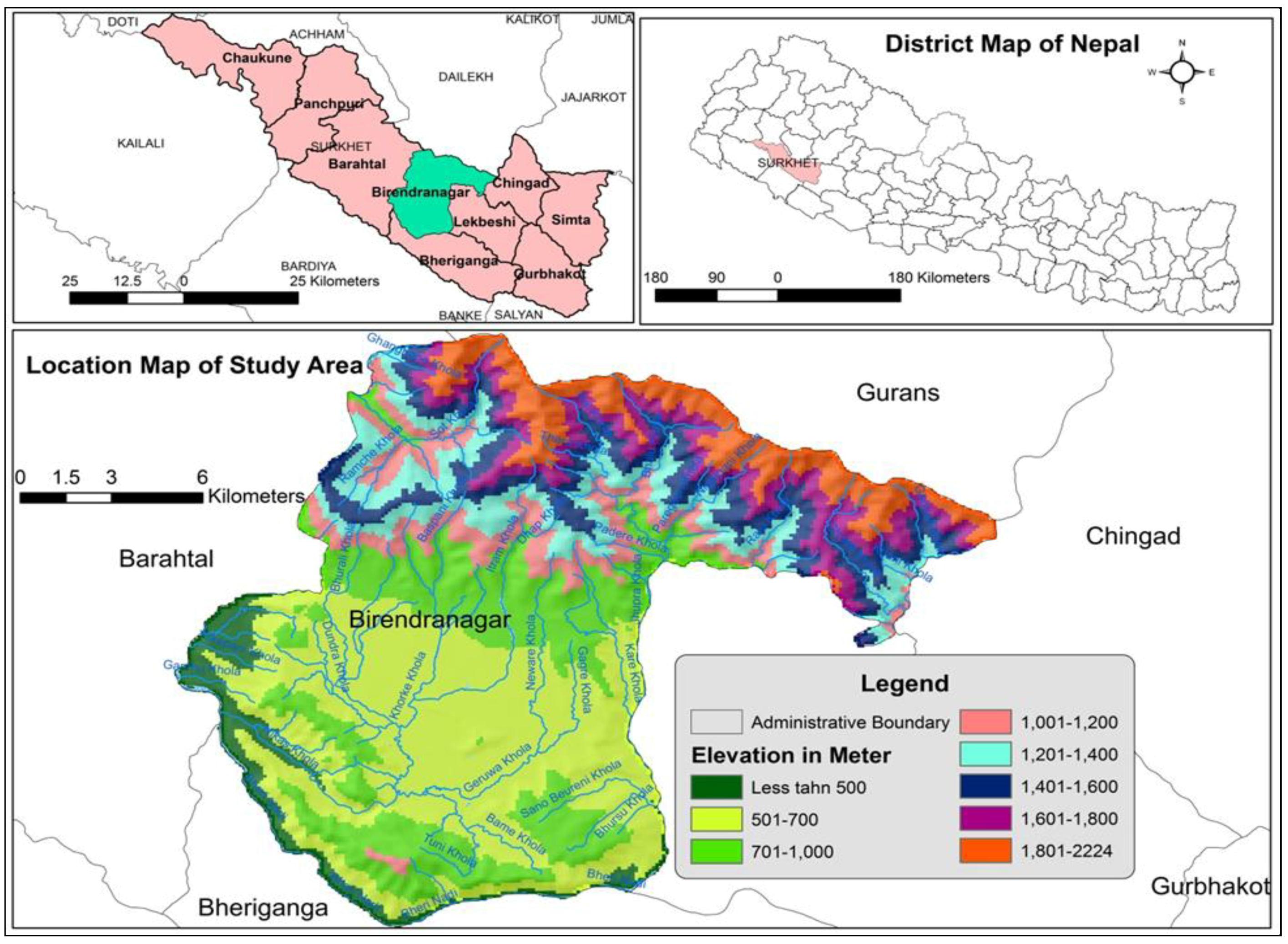
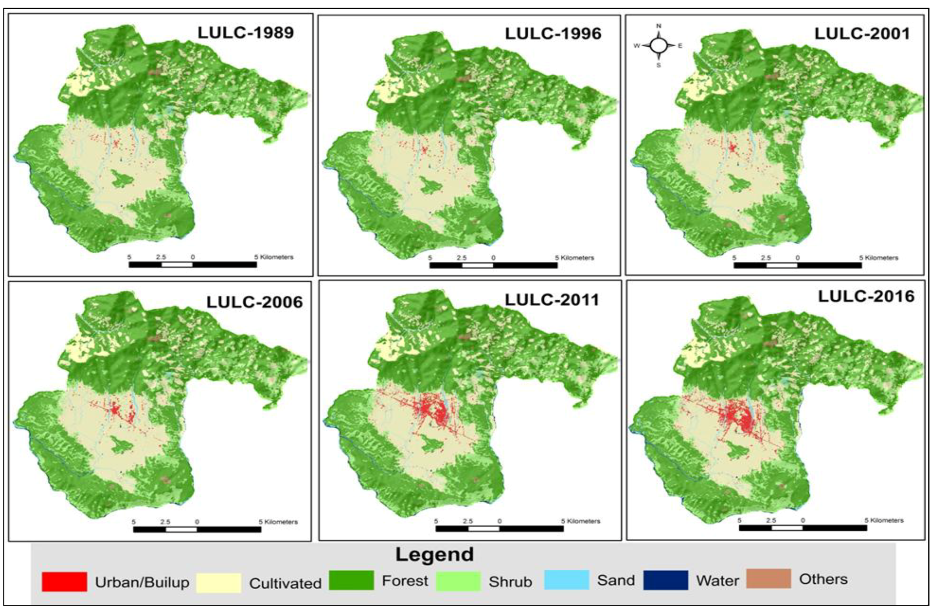

| Year | 1981 | 1991 | 2001 | 2011 | 2015 |
|---|---|---|---|---|---|
| Population | 13,859 | 22,973 | 31,381 | 93,718 | 100,458 |
| Land-Cover Types | Description |
|---|---|
| Urban (built up) | Urban and rural settlements, commercial areas, industrial areas, construction areas, traffic, airports, public service areas (e.g., schools, colleges, hospitals) |
| Cultivated land | Wet and dry crop lands, orchards |
| Forest | Evergreen broad leaf forest, deciduous forest, scattered forest, degraded forest |
| Shrub | Mix of trees (<5 m tall) and other natural covers |
| Sand | Sand area, other open field area, river bank |
| Water | River, lake/pond, canal, reservoir |
| Others | Cliffs/small landslide, bare rocks, |
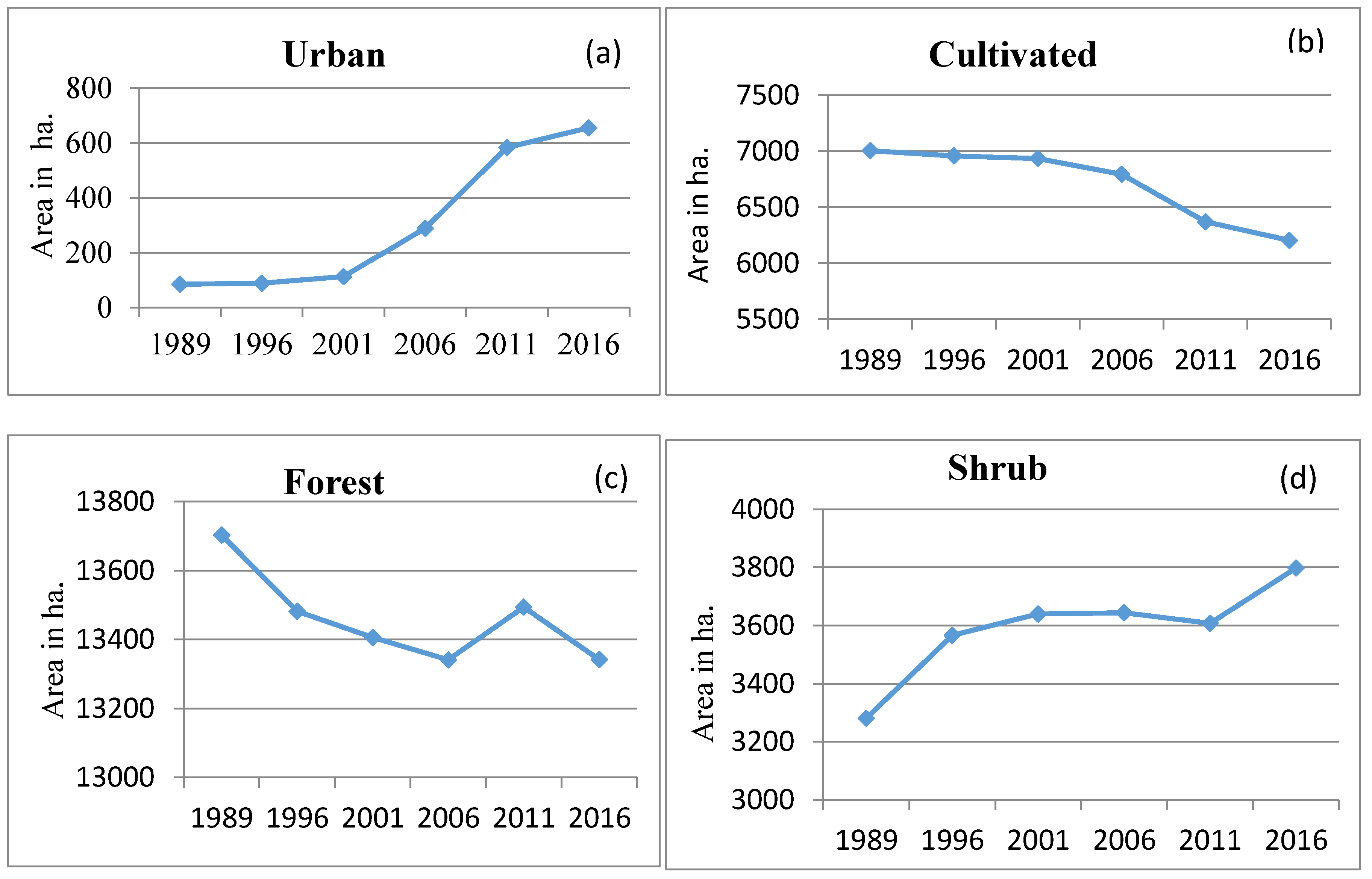
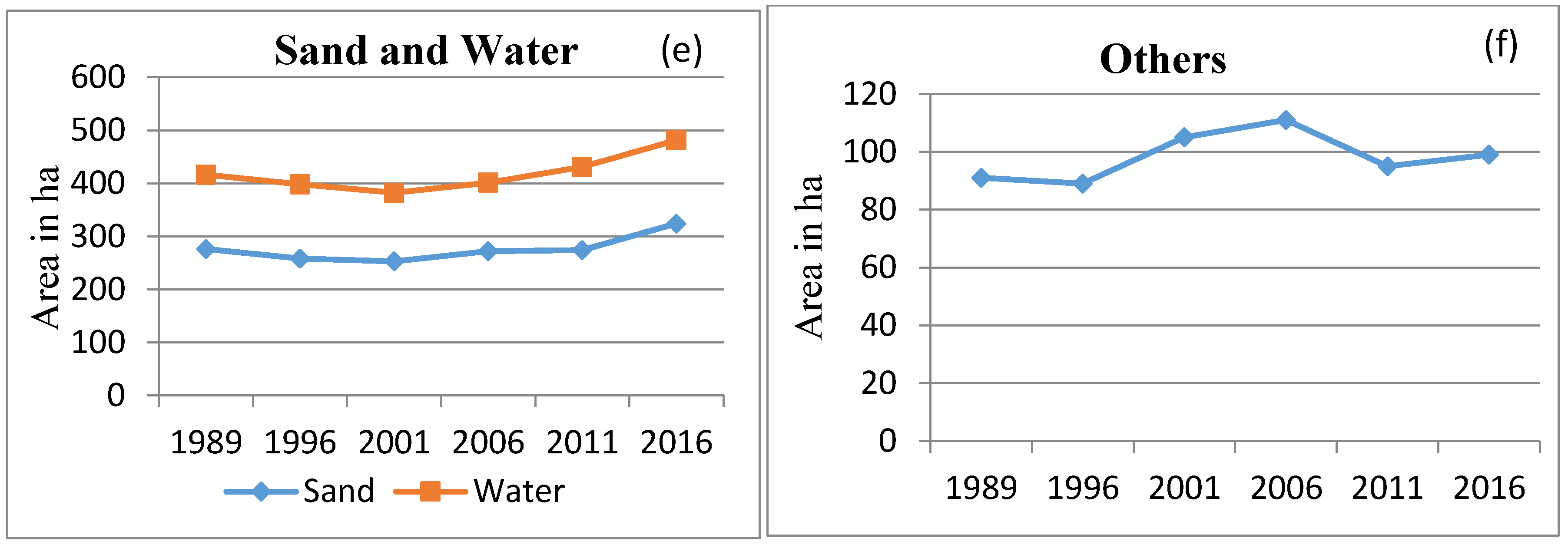
| LULC | 1989 | 1996 | 2001 | 2006 | 2011 | 2016 | 1989–2016 |
|---|---|---|---|---|---|---|---|
| Urban/built up | 85 | 89 | 113 | 289 | 584 | 656 | 571 |
| Cultivated | 7005 | 6958 | 6935 | 6794 | 6371 | 6205 | −800 |
| Forest | 13,703 | 13,482 | 13,406 | 13,341 | 13,494 | 13,342 | −361 |
| Shrub | 3281 | 3566 | 3640 | 3644 | 3608 | 3798 | 517 |
| Sand | 276 | 258 | 253 | 272 | 274 | 324 | 48 |
| Water | 140 | 140 | 129 | 129 | 157 | 157 | 17 |
| Others | 91 | 89 | 105 | 111 | 95 | 99 | 8 |
| Total | 24,582 | 24,582 | 24,582 | 24,582 | 24,582 | 24,582 |
© 2018 by the authors. Licensee MDPI, Basel, Switzerland. This article is an open access article distributed under the terms and conditions of the Creative Commons Attribution (CC BY) license (http://creativecommons.org/licenses/by/4.0/).
Share and Cite
Rijal, S.; Rimal, B.; Sloan, S. Flood Hazard Mapping of a Rapidly Urbanizing City in the Foothills (Birendranagar, Surkhet) of Nepal. Land 2018, 7, 60. https://doi.org/10.3390/land7020060
Rijal S, Rimal B, Sloan S. Flood Hazard Mapping of a Rapidly Urbanizing City in the Foothills (Birendranagar, Surkhet) of Nepal. Land. 2018; 7(2):60. https://doi.org/10.3390/land7020060
Chicago/Turabian StyleRijal, Sushila, Bhagawat Rimal, and Sean Sloan. 2018. "Flood Hazard Mapping of a Rapidly Urbanizing City in the Foothills (Birendranagar, Surkhet) of Nepal" Land 7, no. 2: 60. https://doi.org/10.3390/land7020060
APA StyleRijal, S., Rimal, B., & Sloan, S. (2018). Flood Hazard Mapping of a Rapidly Urbanizing City in the Foothills (Birendranagar, Surkhet) of Nepal. Land, 7(2), 60. https://doi.org/10.3390/land7020060


