Mapping Land Cover and Estimating the Grassland Structure in a Priority Area of the Chihuahuan Desert

 , ,
, ,  and
and
Abstract
1. Introduction
2. Materials and Methods
2.1. Samples and Processing Date
2.2. Statistical Analysis
2.3. Maps of Cover of Grass Canopy and Grass Height
2.4. Meteorological Data
3. Results
3.1. Field Data
3.2. Spectral Data
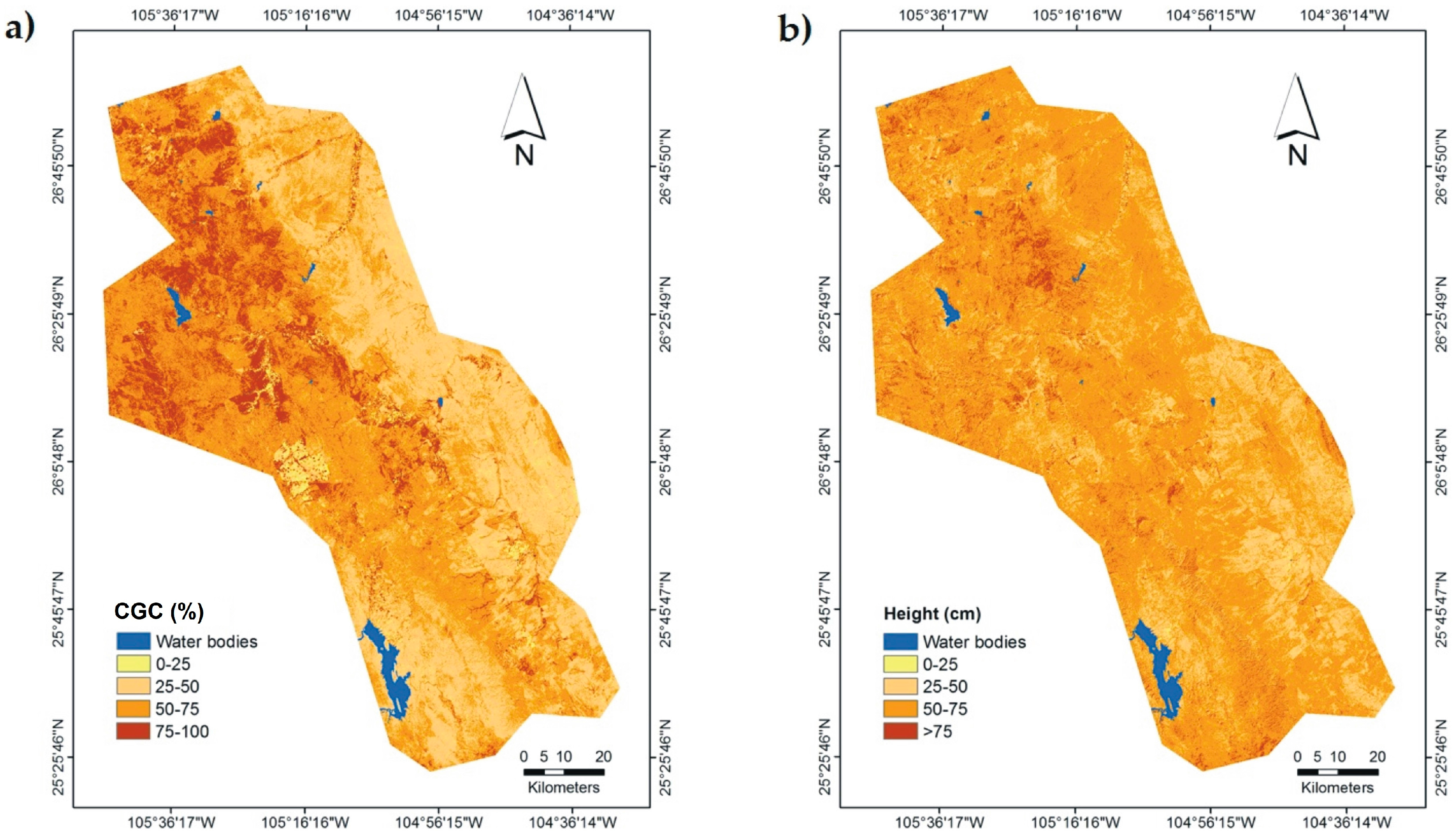
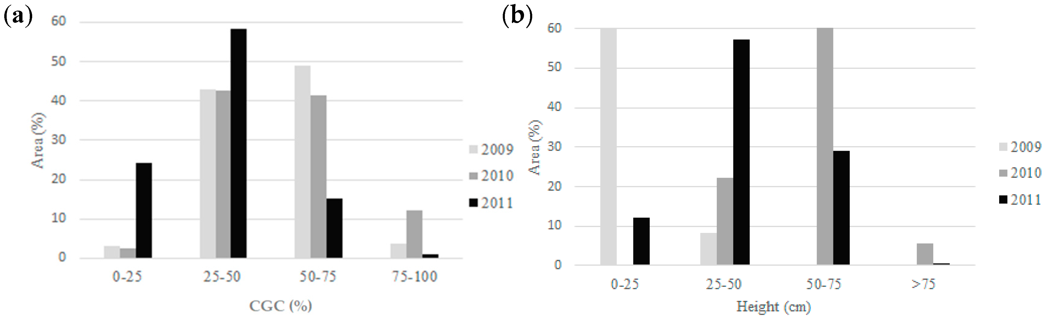
3.3. Distribution Maps of CGC, Grass Height and Kappa Index
4. Discussion
5. Conclusions
Acknowledgments
Author Contributions
Conflicts of Interest
References
- Adams, J.M.; Hugues, F.; Denard, F.L.; McGlade, J.; Woodward, I.F. Increases in Terrestrial Carbon Storage from the Last Glacial Maximum to the Present. Nature 1990, 348, 711–714. [Google Scholar] [CrossRef]
- Peng, J.; Zhenhuan, L.; Yinghui, L.; Jiansheng, W.; Yinan, H. Trend Analysis of Vegetation Dynamics in Qinghai. Tibet Plateau using Hurst Exponent. Ecol. Indic. 2012, 14, 28–39. [Google Scholar] [CrossRef]
- Herrera, A.Y.; Cortes, O.A. Listado Florístico y Aspectos Ecológicos de la Familia Poaceae Para Chihuahua, Durango y Zacatecas, México. J. Bot. Res. Inst. Tex. 2010, 4, 711–738. [Google Scholar]
- Pool, D.B.; Panjabi, A.O.; Macias, D.; Solhjem, M. Rapid Expansion of Croplands in Chihuahua, Mexico Threatens Declining North American Grassland Bird Species. Biol. Conserv. 2014, 170, 274–281. [Google Scholar] [CrossRef]
- Manjarrez, D.C.; Pinedo, A.A.; Pinedo, A.C.; Villarreal, G.F.; Cortes, P.L. Vegetation Landscape Analysis due to Land Use Changes on Arid Lands. Pol. J. Ecol. 2015, 63, 272–279. [Google Scholar] [CrossRef]
- Hoekstra, M.J.; Boucher, T.M.; Taylor, H.R.; Carter, R. Confronting a Biome Crisis: Global Disparities of Habitat Loss and Protection. Ecol. Lett. 2005, 8, 23–29. [Google Scholar] [CrossRef]
- USGS (United States Geological Survey). The North American Breeding Bird Survey, Results and Analysis 1966–2012. Available online: http://www.mbr-pwrc.usgs.gov/bbs/ (accessed on 5 May 2014).
- Macias, D.A.; Montoya, A.B.; Gonzalez, M.C.E.; Rodriguez, S.J.R.; Hunt, W.G.; Krannitz, P.G. Factors Influencing Habitat Use by Migratory Grassland Birds in the State of Chihuahua, Mexico. Auk 2009, 126, 896–905. [Google Scholar] [CrossRef]
- Guo, Q.; Zhongmin, H.; Shenggong, Li.; Xuanran, L.; Xiaomin, S.; Guirui, Y. Spatial Variations in Aboveground Net Primary Productivity Along a Climate Gradient in Eurasian Temperate Grassland: Effects of Mean Annual Precipitation and Its Seasonal Distribution. Glob. Chang. Biol. 2012, 18, 3624–3638. [Google Scholar] [CrossRef]
- Reichmann, G.L.; Sala, E.O.; Debra, P.C. Precipitation Legacies in Desert Grassland Primary Production Occur through Previous-Year Tiller Density. Ecology 2013, 94, 435–443. [Google Scholar] [CrossRef] [PubMed]
- Granados, S.D.; Sanchez, G.A.; Granados, R.L.V.; De la Rosa, B.A. Ecología de la Vegetación del Desierto Chihuahuense. Revista Chapingo. Serie Ciencias Forestales y del Ambiente 2011, 17, 111–130. [Google Scholar] [CrossRef]
- Arellano, E.C.; Vidal, L.J.C.; García, H.L.; Laundré, W.J.; Reza, C.F.; Mejia, M.F.M.; Vargas, R.M.; Galaviz, D.L.F.; Romero, G.A.; Spilsbury, M.A. Registro de Presencia y Actividades de Algunos Mamíferos en el Desierto Chihuahuense, México. THERYA 2014, 5, 793–816. [Google Scholar] [CrossRef]
- Manzano, P.; List, R. Grasslands of Mexico: A Perspective on Their Conservation. In Proceedings of the Grasslands Ecosystems, Endangered Species, and Sustainable Ranching in the Mexico-U.S. Borderlands, Conference Proceedings, Fort Collins, CO, USA, 2006; Basurto, X., Hadley, D., Eds.; United States Department of Agriculture: Erie, KS, USA, 2006; pp. 43–47. [Google Scholar]
- Martínez, G.J.H.; Pereda, S.M.E.; Wehenkel, C. Association of Ammodramus Bairdii A. 1844, and Other Species of grassland Granivorous Birds in Winter Time in Northwestern Mexico. Open J. Ecol. 2014, 4, 281–288. [Google Scholar] [CrossRef]
- Czerwinski, C.J.; Douglas, J.K.; Scott, W.M. Mapping Forest Growth and Decline in a Temperate Mixed Forest Using Temporal Trend Analysis of Landsat Imagery, 1987–2010. Remote Sens. Environ. 2014, 141, 188–200. [Google Scholar] [CrossRef]
- Vittek, M.; Brink, A.; Donnay, F.; Simonetti, D.; Desclée, B. Land Cover Change Monitoring Using Landsat MSS/TM Satellite Image Data over West Africa between 1975 and 1990. Remote Sens. 2014, 6, 658–676. [Google Scholar] [CrossRef]
- Goward, S. N.; Masek, G.J.; Williams, L.D.; Irons, R.J.; Thompson, R.J. The Landsat 7 Mission: Terrestrial Research and Applications for the 21st Century. Remote Sens. Environ. 2001, 78, 3–12. [Google Scholar] [CrossRef]
- Wulder, A.M.; Masek, G.J.; Cohen, B.W.; Loveland, R.T.; Woodcock, E.C. Opening the Archive: How Free Data Has Enabled the Science and Monitoring Promise of Landsat. Remote Sens. Environ. 2012, 122, 2–10. [Google Scholar] [CrossRef]
- Hansen, M.C.; Loveland, T.R. A Review of Large are Monitoring of Land Cover Change Using Landsat data. Remote Sens. Environ. 2012, 122, 66–74. [Google Scholar] [CrossRef]
- Coppin, P.; Jonckheere, I.; Nackaerts, K.; Muys, B.; Lambin, E. Digital Change Detection Methods in Ecosystem Monitoring: A Review. Int. J. Remote Sens. 2004, 25, 1565–1596. [Google Scholar] [CrossRef]
- Krofcheck, D.J.; Eitel, U.H.J.; Vierling, A.L.; Schulthess, U.; Hilton, M.T.; Dettweiler, R.E.; Pendleton, R.; Litvak, E.M. Detecting Mortality Induced Structural and Functional Changes in a Piñon-Juniper Woodland Using Landsat and RapidEye Time Series. Remote Sens. Environ. 2014, 151, 102–113. [Google Scholar] [CrossRef]
- Schmitt, H.M.; Sweeney, P.S.; Evans, P.T. Classification of Coffee-Forest Landscapes Using Landsat TM Imagery and Spectral Mixture Analysis. Photogramm. Eng. Remote Sens. 2013, 79, 457–468. [Google Scholar] [CrossRef]
- Sivanpillai, R.; Ewers, E.B. Relationship between Sagebrush Species and Structural Characteristics and Landsat Thematic Mapper data. Appl. Veg. Sci. 2013, 16, 122–130. [Google Scholar] [CrossRef]
- Pucheta, E.E.; Heil, F.L.; Schneider, C. Modelos de Regresión Para la Estimación de la Biomasa Aérea en un Pastizal de Montaña de Pampa de Achala. (Córdoba, Argentina). AGRISCIENTIA 2004, 21, 23–30. [Google Scholar]
- Manrique, S.; Nuñez, V.; Franco, J.; Seghezzo, L. Prediccion de Biomasa Natural a Partir de Sensores Remotos en el Valle de Lerma. Avances en Energías Renovables y Medio Ambiente 2010, 14, 63–70. [Google Scholar]
- Calvert, M.A.; Walde, J.S.; Taylor, D.P. Non-breeding Drivers of Population Dynamics in Seasonal Migrants: Conservation Parallels Across Taxa. Avian Conserv. Ecol. 2009, 4, 5. [Google Scholar] [CrossRef]
- Chaneton, J.E. Factores que Determinan la Heterogeneidad de la Comunidad Vegetal en Diferentes Escalas Espaciales. In La Heterogeneidad de la Vegetación de los Agroecosistemas; Oesterheld, M., Aguiar, M.R., Ghersa, C.M., Paruelo, J.M., Eds.; Editorial Facultad de Agronomía-UBA: Buenos Aires, Argentina, 2005; pp. 19–42. [Google Scholar]
- Hoyt, A.C. The Chihuahuan Desert: Diversity at Risk. Endanger. Species Bull. 2002, 27, 16–17. [Google Scholar]
- Rzedowski, J. Vegetación de México; Limusa: Mexico City, México, 1981; p. 504. [Google Scholar]
- De León, M.D.; Pinedo, A.A.; Martínez, G.J.H. Aplicación de Sensores Remotos en el Análisis de la Fragmentación del Paisaje en Cuchillas de la Zarca, México. Investigaciones Geográficas, Boletín del Instituto de Geografía 2014, 84, 42–53. [Google Scholar] [CrossRef]
- CONABIO. (Comisión Nacional para el Conocimiento y Uso de la Biodiversidad). Catálogo de Metadatos Geográficos. Red de Carreteras Escala 1:10,000,000. Available online: http://www.conabio.gob.mx/informacion/metadata/gis/carre1mgw.xml?_xsl=/db/metadata/xsl/fgdc_html.xsl&_indent=no (accessed on 16 October 2017).
- Crist, P.E.; Richard, C.C. A Physically Based Transformation of Thematic Mapper Data-The TM Tasseled Cap. IEEE Trans. Geosci. Remote Sens. 1984, 22, 256–263. [Google Scholar] [CrossRef]
- Chander, G.; Markham, L.B.; Helder, L.D. Summary of Current Radiometric Calibration Coefficients for Landsat MSS, TM, ETM+, and EO-1 ALI Sensors. Remote Sens. Environ. 2009, 113, 893–903. [Google Scholar] [CrossRef]
- Chuvieco, S.E. Teledetección Ambiental: La Observación de la Tierra Desde el Espacio; Ariel Ciencia: Barcelona, Spain, 2002. [Google Scholar]
- Dobson, J.A.; Barnett, A. An Introduction to Generalized Linear Models; Taylor & Francis Group: New York, NY, USA, 2008. [Google Scholar]
- Rosenfield, H.G.; Fitzpatric, K.L. A Coefficient of Agreement as a Measure of Thematic Classification Accuracy. Photogramm. Eng. Remote Sens. 1986, 52, 223–227. [Google Scholar]
- Eastman, R.J. Idrisi Selva; Version 17; Clark Labs, Clark University: Worcester MA, USA, 2012. [Google Scholar]
- SMN. Monitor de Sequía de México. Available online: http://smn.cna.gob.mx (accessed on 15 January 2014).
- Wiles, L.J.; Dunn, G.; Printz, J.; Patton, B.; Nyren, A. Spring Precipitation as a Predictor for Peak Standing Crop of Mixed-Grass Prairie. Rangel. Ecol. Manag. 2011, 64, 215–222. [Google Scholar] [CrossRef]
- Cohen, B.W.; Maiersperger, K.T.; Gowerc, T.S.; Turner, P.D. An Improved Strategy for Regression of Biophysical Variables and Landsat ETM+ Data. Remote Sens. Environ. 2003, 84, 561–571. [Google Scholar] [CrossRef]
- Xie, Y.; Sha, Z.; Yu, M.; Bai, Y.; Zhang, L. A Comparison of Two Models with Landsat Data for Estimating above Ground Grassland Biomass in Inner Mongolia, China. Ecol. Model. 2009, 220, 1810–1818. [Google Scholar] [CrossRef]
- Gasparri, I.; Parmuchi, M.G.; Bono, J.; Karszenbaum, H.; Montenegro, C.L. Assessing Multi-Temporal Landsat ETM+ Images for Estimating Above-Ground Biomass in Subtropical Dry Forests of Argentina. J. Arid Environ. 2010, 74, 1262–1270. [Google Scholar] [CrossRef]
- Karl, W.J. Spatial Predictions of cover Attributes of Rangeland Ecosystems Using Regression Kriging and Remote Sensing. Rangel. Ecol. Manag. 2010, 63, 335–349. [Google Scholar] [CrossRef]
- Song, C.; Woodcock, E.; Seto, C.K.; Lenney, P.M.; Macomber, A.S. Classification and Change Detection Using Landsat TM data: When and How to Correct Atmospheric Effects? Remote Sens. Environ. 2001, 75, 230–244. [Google Scholar] [CrossRef]
- Lencinas, D.J.; Bell, M.D. Estimación de Clases de Edad de las Plantaciones de la Provincia de Corrientes, Argentina, con Base en Datos Satelitales Landsat. Bosque 2007, 28, 106–118. [Google Scholar] [CrossRef]
- Khumalo, G.; Holechek, J. Relationships between Chihuahuan Desert Perennial Grass Production and Precipitation. Rangel. Ecol. Manag. 2005, 58, 239–246. [Google Scholar] [CrossRef]
- Yahner, H.R. Wildlife Behavior and Conservation; Springer Science: New York, NY, USA, 2012. [Google Scholar]
- Jin, Y.; Yang, X.; Qiu, J.; Li, J.; Gao, T.; Wu, Q.; Zhao, F.; Ma, H.; Yu, H.; Xu, B. Remote Sensing-Based Biomass Estimation and Its Spatio-Temporal Variations in Temperate Grassland, Northern China. Remote Sens. 2014, 6, 1496–1513. [Google Scholar] [CrossRef]
- Duru, M.; Ducrocq, H. Growth and Senescence of the Successive Grass Leaves on a Tiller. Ontogenic Development and Effect of Temperature. Ann. Bot. 2000, 85, 635–643. [Google Scholar] [CrossRef]
- Westoby, M.; Walker, B.; Noy-Meir, I. Opportunistic Management for Rangelands Not at Equilibrium. J. Range Manag. 1989, 42, 266–274. [Google Scholar] [CrossRef]
- Si, Y.; Schlerf, M.; Zurita, M.R.; Skidmore, A.; Wang, T. Mapping Spatio-Temporal Variation of Grassland Quantity and Quality Using MERIS Data and the PROSAIL Model. Remote Sens. Environ. 2012, 121, 415–425. [Google Scholar] [CrossRef]
- Gao, T.; Yang, X.; Jin, Y.; Ma, H.; Li, J.; Yu, H.; Yu, Q.; Zheng, X.; Xu, B. Spatio-Temporal Variation in Vegetation Biomass and Its Relationships with Climate Factors in the Xilingol Grasslands, Northern China. PLoS ONE 2013, 8, e83824. [Google Scholar] [CrossRef] [PubMed]
- Martínez, G.J.H.; Wehenkel, C.; Pereda, S.E.; Panjabi, A.; Levandoski, G.; Corral, R.J.; Díaz, M.R. Relación Entre la Cobertura del Suelo y Atributos de la Vegetación Invernal con Ammodramus Bairdii, Audubon 1844, en el Noroeste de México. Agrociencia 2011, 45, 443–451. [Google Scholar]
- Hovick, J.T.; Elmore, D.R.; Fuhlendorf, D.S. Structural Heterogeneity Increases Diversity of Non-Breeding Grassland Birds. Ecosphere 2014, 5, 1–13. [Google Scholar] [CrossRef]
- McGranahan, A.D.; Raicovich, M.G.; Wilson, N.W.; Smith, K.C. Preliminary Evidence that Patch Burn-Grazing Creates Spatially Heterogeneous Habitat Structure in Old-Field Grassland. Southeast. Nat. 2013, 12, 655–660. [Google Scholar] [CrossRef]
- Moreau, S.; Bosseno, R.; Gu, X.; Baret, F. Assessing the Biomass Dynamics of Andean Bofedal and Totora high-Protein Wetland Grasses from NOAA/AVHRR. Remote Sens. Environ. 2003, 85, 516–529. [Google Scholar] [CrossRef]
- Martin, L.M.; Moloney, K.A.; Wilsey, B.J. An Assessment of Grassland Restoration Success Using Species Diversity Components. J. Appl. Ecol. 2005, 42, 327–336. [Google Scholar] [CrossRef]
- Kawamura, K.; Akiyama, T.; Yokot, H.; Tsutsumi, M.; Yasuda, T.; Watanabe, O.; Wang, S. Quantifying Grazing Intensities Using Geographic Information Systems and Satellite Remote Sensing in the Xilingol Steppe Region, Inner Mongolia, China. Agric. Ecosyst. Environ. 2005, 107, 83–93. [Google Scholar] [CrossRef]


| QUADRANT | CGC (%) | Grass Height (cm) | ||||
|---|---|---|---|---|---|---|
| 2009 | 2010 | 2011 | 2009 | 2010 | 2011 | |
| 1 | 65.5 | 57.8 | 54.3 | 9.0 | 13.5 | 12.2 |
| 2 | 63.0 | 58.8 | 59.9 | 15.8 | 25.9 | 30.8 |
| 3 | 50.7 | 49.8 | 44.1 | 13.4 | 8.2 | 7.3 |
| 4 | 68.1 | 61.2 | 66.0 | 16.9 | 28.9 | 27.6 |
| 5 | 57.7 | 45.4 | 55.6 | 19.8 | 15.8 | 12.5 |
| 6 | 49.8 | 52.7 | 46.1 | 8.7 | 10.6 | 9.4 |
| 7 | 67.1 | 69.5 | 67.8 | 19.6 | 30.2 | 32.7 |
| 8 | 60.6 | 51.2 | 55.2 | 8.3 | 15.4 | 11.3 |
| 9 | 60.6 | 58.3 | 61.9 | 9.2 | 25.5 | 20.0 |
| 10 | 65.1 | 65.3 | 60.2 | 13.2 | 20.1 | 17.4 |
| 11 | 70.9 | 62.9 | 65.5 | 11.9 | 21.3 | 23.5 |
| 12 | 60.5 | 53.8 | 57.5 | 8.7 | 15.9 | 20.0 |
| 13 | 66.5 | 41.8 | 50.8 | 11.2 | 22.6 | 15.9 |
| 14 | 49.5 | 51.2 | 53.7 | 12.4 | 20.6 | 21.7 |
| 15 | 41.3 | 26.6 | 27.5 | 7.0 | 9.7 | 9.8 |
| 16 | 36.0 | 16.8 | 22.3 | 10.4 | 15.3 | 19.8 |
| 17 | - | 64.0 | 64.0 | - | 27.3 | 24.4 |
| Variable | Year | Statistics | Mean Square Error | |||||
|---|---|---|---|---|---|---|---|---|
| R2 | DIC | AIC | BIC | RMSE | Training | Validation | ||
| CGC | 2011 | 0.81 | 11945 | 753.51 | 776.6 | 10.55 | 115.5 | 114.4 |
| 2010 | 0.81 | 11945 | 753.51 | 776.59 | 11.15 | 118.7 | 117.4 | |
| 2009 | 0.72 | 10090 | 630.01 | 649.07 | 11.23 | 92.0 | 91.3 | |
| Grass Height | 2011 | 0.82 | 0.38 | −265.1 | −244.1 | 0.060 | 50.2 | 48.7 |
| 2010 | 0.79 | 0.49 | −215.8 | −192.7 | 0.071 | 69.5 | 68.7 | |
| 2009 | 0.73 | 6027.2 | 588.8 | 607.8 | 0.067 | 67.3 | 65.9 | |
| Year | Intercept | B1 | B2 | B3 | B4 | B5 | B7 | TCb |
|---|---|---|---|---|---|---|---|---|
| 2011 | −8.5 | 2.2 | −6.9 * | 1.9 | 0.9 | 0.3 | −2.3 * | 0.7 |
| 2010 | 29 | 1.6 | −1.8 | 3.0 | 2.0 | 2.3 | −2.8 * | −2.4 |
| 2009 | −5.4 | 2.5 | −4.9 | 3.8 | −1.9 | 1.7 * | −3.4 * | N/A |
| Year | Intercept | B1 | B2 | B3 | B4 | B5 | B7 | TCw |
|---|---|---|---|---|---|---|---|---|
| 2011 | 0.51 * | 0.02 | −0.07 * | 0.04 * | −0.01 | 0.01 * | −0.02 * | |
| 2010 | 0.87 * | 0.03 * | −0.03 | 0.06 * | 0.02 | −0.06 | −0.06 * | −0.09 |
| 2009 | 88.4 * | −2.04 | 4.1 | 0.12 | −0.61 | 0.87 * | −2.6 * |
| CGC | |||
| 2009 | 2010 | 2011 | |
| 1 | 0.59 ** | 0.56 ** | 2009 |
| 1 | 0.49 ** | 2010 | |
| Grass Height | |||
| 2009 | 2010 | 2011 | |
| 1 | 0.36 * | 0.40 * | 2009 |
| 1 | 0.59 ** | 2010 | |
© 2017 by the authors. Licensee MDPI, Basel, Switzerland. This article is an open access article distributed under the terms and conditions of the Creative Commons Attribution (CC BY) license (http://creativecommons.org/licenses/by/4.0/).
Share and Cite
Rodríguez-Maturino, A.; Martínez-Guerrero, J.H.; Chairez-Hernández, I.; Pereda-Solis, M.E.; Villarreal-Guerrero, F.; Renteria-Villalobos, M.; Pinedo-Alvarez, A. Mapping Land Cover and Estimating the Grassland Structure in a Priority Area of the Chihuahuan Desert. Land 2017, 6, 70. https://doi.org/10.3390/land6040070
Rodríguez-Maturino A, Martínez-Guerrero JH, Chairez-Hernández I, Pereda-Solis ME, Villarreal-Guerrero F, Renteria-Villalobos M, Pinedo-Alvarez A. Mapping Land Cover and Estimating the Grassland Structure in a Priority Area of the Chihuahuan Desert. Land. 2017; 6(4):70. https://doi.org/10.3390/land6040070
Chicago/Turabian StyleRodríguez-Maturino, Alberto, José Hugo Martínez-Guerrero, Isaías Chairez-Hernández, Martín Emilio Pereda-Solis, Federico Villarreal-Guerrero, Marusia Renteria-Villalobos, and Alfredo Pinedo-Alvarez. 2017. "Mapping Land Cover and Estimating the Grassland Structure in a Priority Area of the Chihuahuan Desert" Land 6, no. 4: 70. https://doi.org/10.3390/land6040070
APA StyleRodríguez-Maturino, A., Martínez-Guerrero, J. H., Chairez-Hernández, I., Pereda-Solis, M. E., Villarreal-Guerrero, F., Renteria-Villalobos, M., & Pinedo-Alvarez, A. (2017). Mapping Land Cover and Estimating the Grassland Structure in a Priority Area of the Chihuahuan Desert. Land, 6(4), 70. https://doi.org/10.3390/land6040070