Modeling Soil and Woody Vegetation in the Senegalese Sahel in the Context of Environmental Change


Abstract
:1. Introduction
2. Materials and Methods
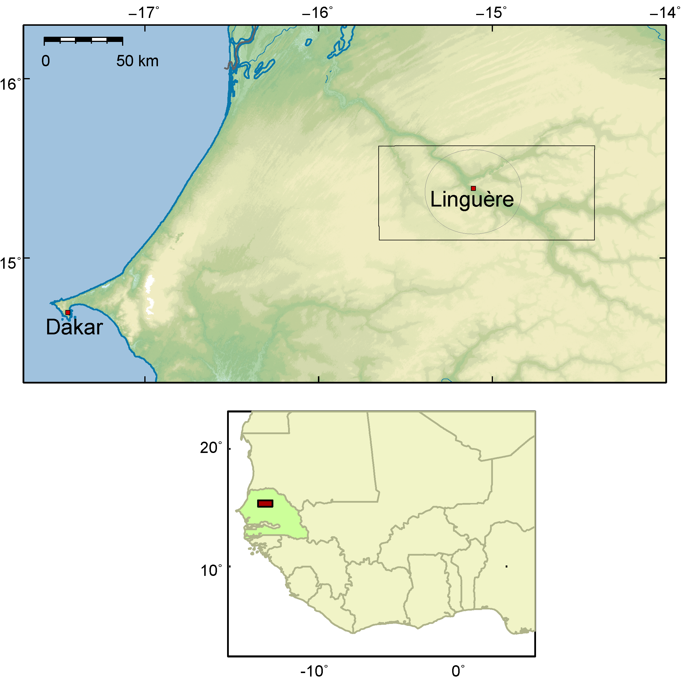
2.1. Study Area

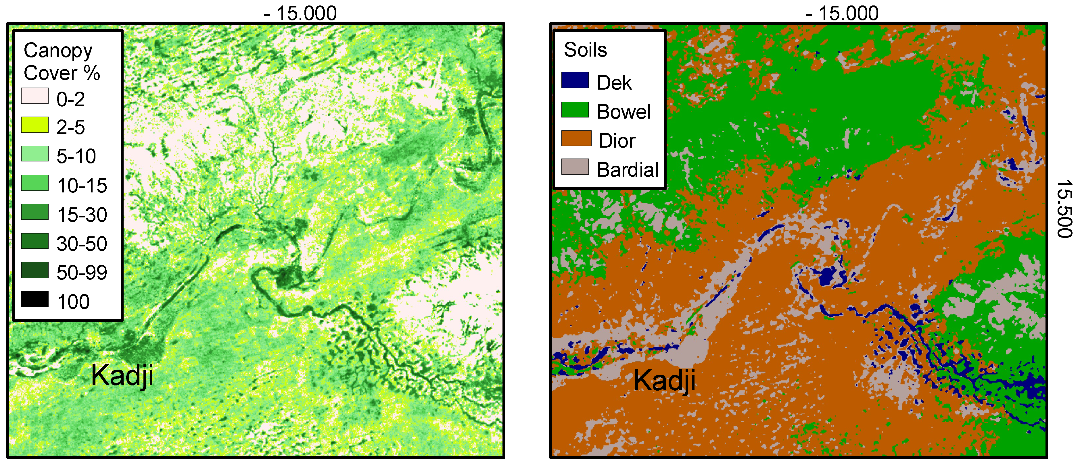
| Wolof Soil | Wolof Morphological Unit | Soil Characteristics | Soil Type | Usage |
|---|---|---|---|---|
| (1) Dek | Xour | clayey depression | Vertisol | pasture, drinking water |
| (2) Bowel | All | ferruginous/stony | Regosol | pasture |
| (3) Dior | Tound | sandy dune soil | Arenosol | cropping, pasture |
| (4) Bardial | Tound | heavy sandy dune soil | Arenosol | cropping, pasture |
2.2. Data and Methodology
2.2.1. Fieldwork
2.2.2. Laboratory Analysis
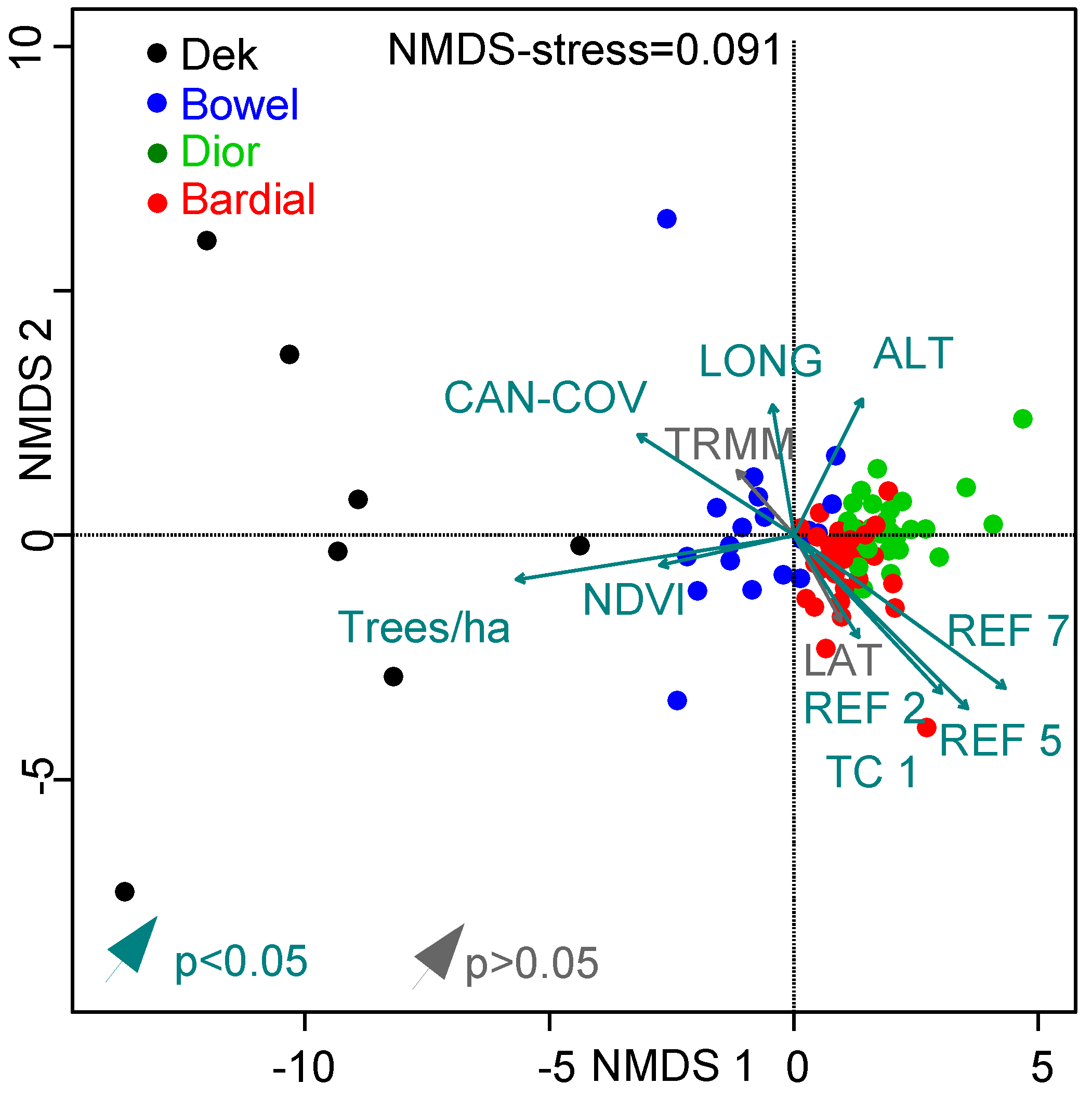
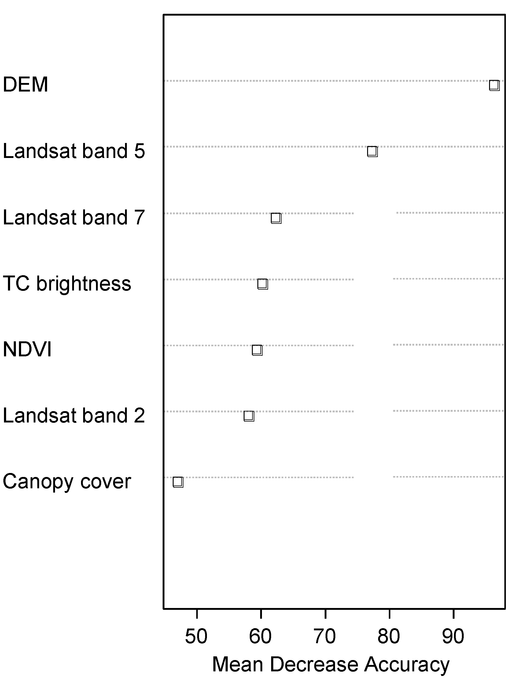
2.2.3. Statistics and Remote Sensing
Model Soil Types
Model Canopy Coverage
3. Results and Discussion
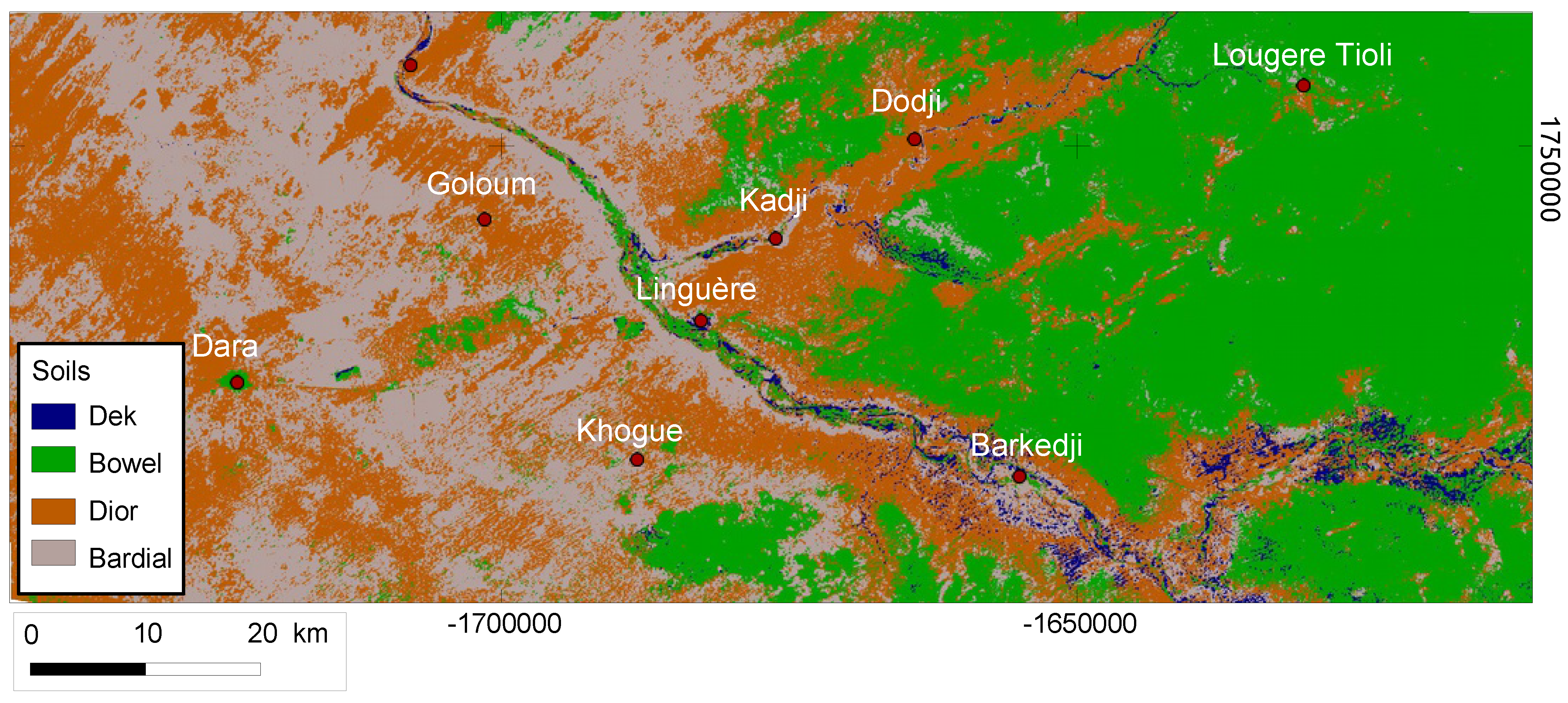
3.1. Soil Clustering Corresponds with Local Denotations
3.2. Soil Types Significantly Differ in Properties
3.3. Modeling Soil Types and Canopy Coverage
3.3.1. Soil Types
| Parameter | Dek | Bowel | Dior | Bardial |
|---|---|---|---|---|
| Samples n | 7 | 19 | 28 | 30 |
| pH (H0) | 5.73 [4.4–8] 1.35 | 6.17 [5.3–8.1] 0.58 | 5.44 [4.9–6.4] 0.33 | 6.13 [5.3–7.4] 0.43 |
| Humus (%) | 1.56 [1.14–1.9] 0.25 | 0.62 [0.38–0.97] 0.21 | 0.34 [0.19–0.44] 0.06 | 0.39 [0.24–0.68] 0.1 |
| N (%) | 0.14 [0.12–0.18] 0.02 | 0.08 [0.05–0.11] 0.02 | 0.06 [0.04–0.08] 0.01 | 0.06 [0.04–0.09] 0.01 |
| CN | 6.8 [5.4–8.1] 0.9 | 4.5 [3–6] 0.9 | 3.4 [1.6–5.8] 0.9 | 3.7 [2.2–5.3] 0.8 |
| P (mg/kg) | 0.21 [0.1–0.5] 0.12 | 0.22 [0.01–1.1] 0.28 | 0.24 [0.04–0.62] 0.17 | 0.48 [0.0–3.2] 0.71 |
| CECpot (cmol/kg) | 9.04 [5.3–21] 5.61 | 2.56 [1.51–4.5] 0.8 | 1.33 [1–1.9] 0.23 | 2.05 [1.1–4.3] 0.84 |
| BS (%) | 97.8 [95.4–99.8] 1.71 | 97.8 [95.5–99.6] 1.2 | 92.7 [78.8–98] 3.75 | 97.5 [95.2–99.6] 1.25 |
| Ca (cmol/kg) | 6.26 [2.75–15.87] 4.68 | 1.6 [0.81–3.32] 0.67 | 0.67 [0.4–1.1] 0.16 | 1.22 [0.63–2.5] 0.5 |
| Mg (cmol/kg) | 1.83 [1.1–4.4] 1.16 | 0.51 [0.25–0.83] 0.16 | 0.24 [0.13–0.36] 0.05 | 0.44 [0.2–1.08] 0.23 |
| K (cmol/kg) | 0.5 [0.34–0.65] 0.11 | 0.18 [0.09–0.27] 0.05 | 0.12 [0.08–0.2] 0.03 | 0.16 [0.06–0.28] 0.05 |
| FC (% vol) | 19 | 22 | 8 | 8 |
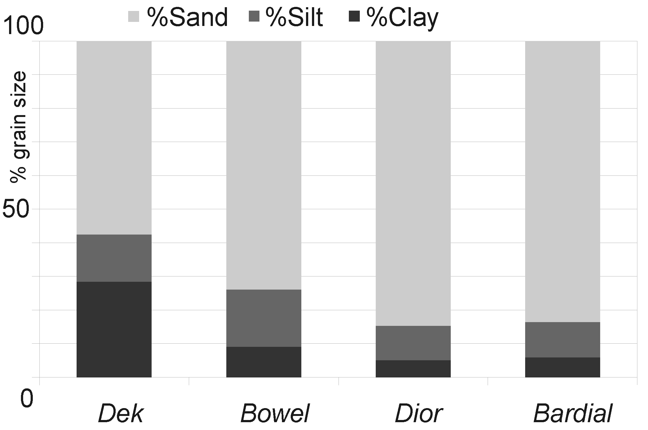
| Sand (%) | 53 [32–65] 10 | 71 [57–81] 7 | 86 [79–92] 4 | 85 [77–93] 4 |
| Clay (%) | 26 [16–38] 7 | 9 [4–20] 4 | 5 [3–9] 1 | 6 [3–10] 2 |
| Stability (3–8) | 7.4 [6–8] 0.8 | 6.1 [5–8] 0.9 | 4.8 [3–7] 1 | 4.9 [3–7] 1.1 |


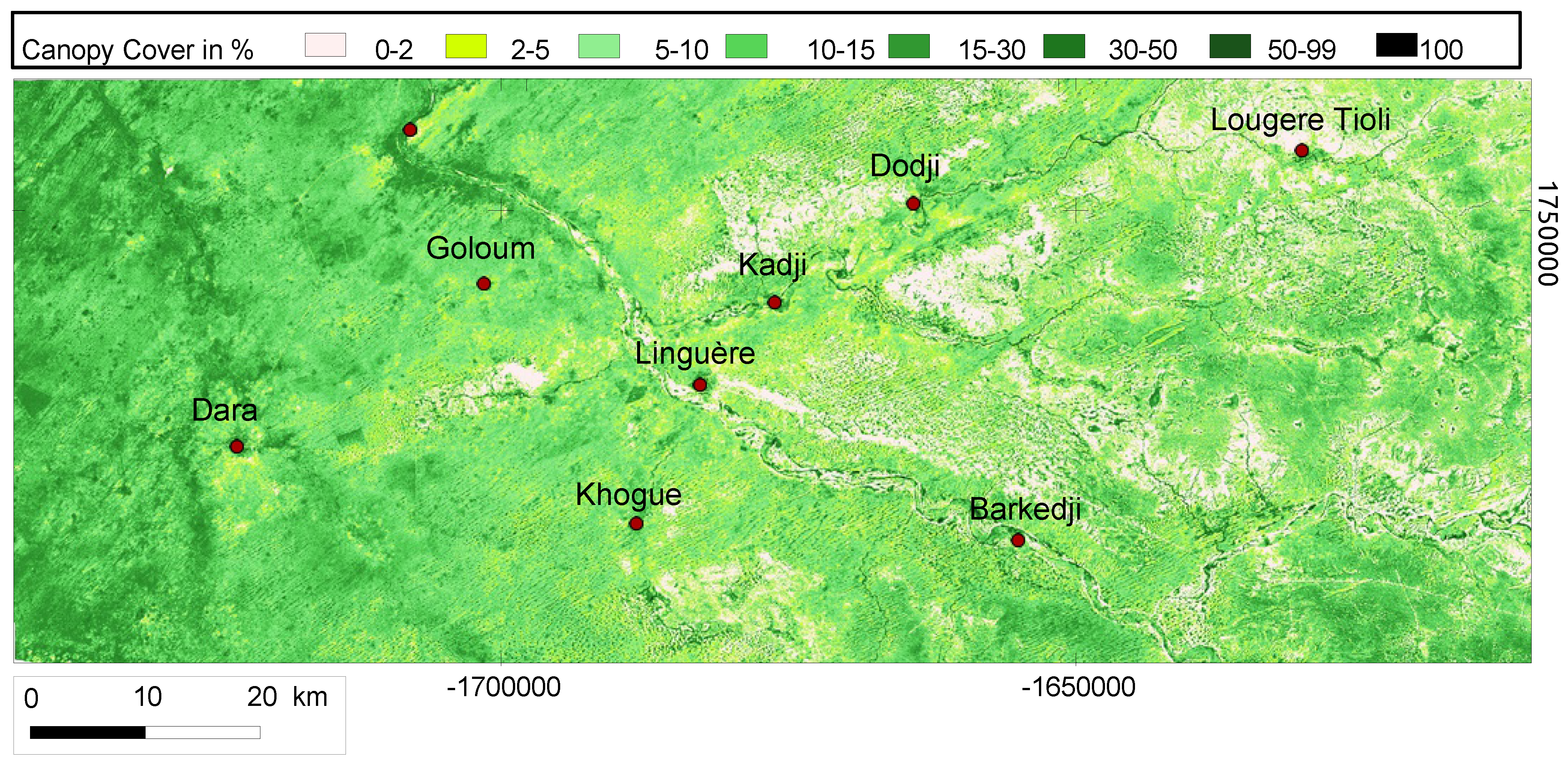
3.3.2. Canopy Coverage


3.3.3. Relationship between Soil and Woody Vegetation
| Parameter | Dek | Bowel | Dior | Bardial |
|---|---|---|---|---|
| % Spatial occurrence | 2 | 38 | 31 | 29 |
| Altitude (m) | 24 | 46 | 39 | 40 |
| NDVI (June) | 0.19 | 0.15 | 0.16 | 0.17 |
| Canopy cover (%) | 18 | 6 | 7 | 10 |
| Canopy cover <1% (%) | 0 | 29 | 9 | 3 |
| Trees/ha (>4 m) * | 53 | 26 | 11 | 15 |
| Tree height (>4 m) (m) * | 8 | 7.62 | 7.2 | 7.8 |
| Tree circumference (>4 m) (cm) * | 70 | 34 | 59 | 63 |
| % Shrubs | 34 | 60 | 77 | 61 |
- (1)
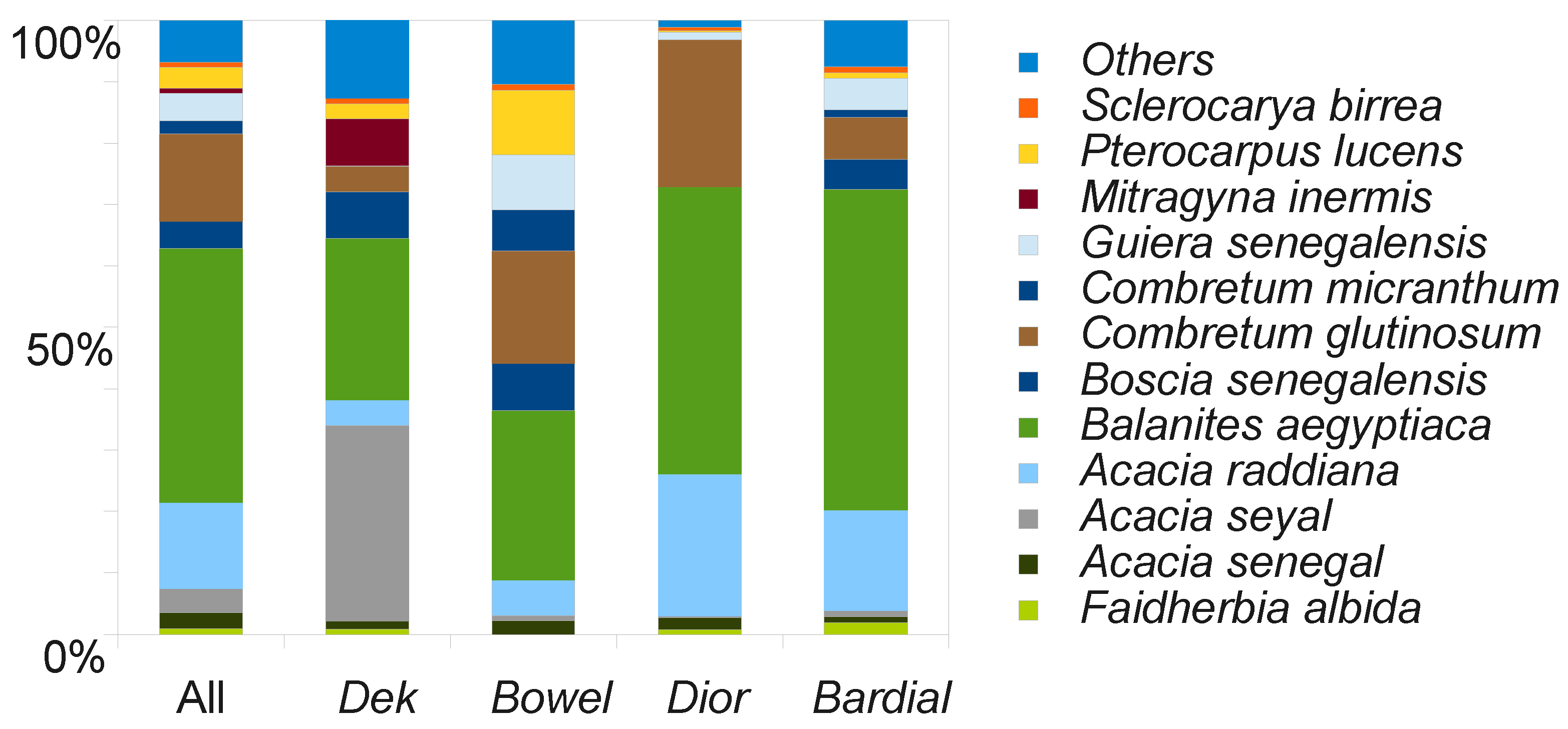
- A majority of rare species such as Mitragyna inermis and Acacia nilotica var. tomentosa are found on Dek soils and are mostly absent in other classes (see Figure 8). Especially the abundance of Acacia seyal is statistically significantly higher ( 0.05) on Dek than in all other classes. Also mean tree height and trunk circumference of trees are greatest for the Dek group. The ratio of shrubs to trees is 34%, showing that large trees are more frequent on hydromorphic soils. Furthermore, trees/ha as well as mean canopy coverage outnumber all other classes. 87% of the classified Dek area exceeds a canopy cover of 10% (Table 3).
- (2)
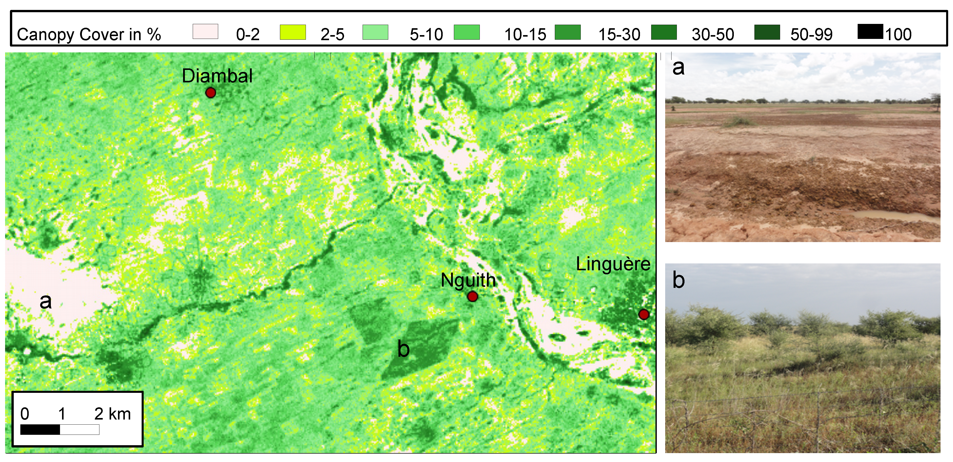
- As mentioned, it is not always easy to draw a strict boundary between a Dek soil within a Xour and a loamy Bowel. However, Bowel Regosols have a unique species composition with significantly higher portions of P. lucens, Guiera senegalensis, Combretum micranthum and Boscia senegalensis than the other classes ( 0.05). This composition follows the soil clustering, which generates only heavy clayey depressions with standing water as Dek and summarizes all lateritic and loamy sites including depressions (Xour) with above mentioned vegetation as Bowel. Species richness on Bowel Regosols is high (Figure 8). Woody cover ranges from 0% to 89% with a mean of 6% due to a very heterogeneous landscape (see Figure 7). 28% of the zone can be considered as relatively dense non-degraded bushland with a canopy cover > 10%, and 55% exceed a canopy cover of 5%. However, 29% of the Bowel soils are deforested, mostly a sign of degradation. Widespread degradation is mainly a problem of the Bowel class, as in all other soil classes combined, deforested areas account for merely 12%. Shrubs or small trees (<4 m) constitute 60% of the woody vegetation, which is evidence for the prevailing shrub savanna (Table 3).
- (3)
- Dior sites have a significantly higher abundance of C. glutinosum ( 0.05) than the other classes, most of them growing on peanut fallows and representing 24% of the woody population on Dior. Numbers in trees/ha, canopy cover, deforested areas and species diversity (Figure 8) are strongly influenced by humans, as most shrubs are cut down when a field is changed from fallow to actively cultivated cropland. Thus, coverage is higher on fallows but still low, since farmers prefer not to have any large trees within their groundnut fields, as trees attract birds which subsist on crops during the harvest. Trees are not needed for fixing nitrogen, as groundnuts and beans are legumes as well. This is also expressed by the percentage of shrubs and small trees (<4 m), which is 77% on Dior. Mean tree height and trunk circumference are slightly lower than on Bardial Arenosols which are used for growing millet (Table 3).
- (4)
3.4. Extensive Environmental Changes are Reported on all Soil Types
- (1)
- Species richness and tree cover on clayey Dek is high, however, both are reported to have considerably declined in the past 50 years. In times of little rainfall, leaves of trees on Dek sites provide an important source of fodder throughout the dry season. These sites are exploited accordingly and often living trees are cut down to make leaves available to animals. Local people report that in combination with droughts and less rainfall, this has led to a strong decrease of large, old trees within Xour areas. Additionally, young trees struggle to survive due to massive numbers of animals who frequent the sites for drinking water, preventing rejuvenation.
- (2)
- Most areas of lateritic Regosols (Bowel) belong to protected regions and are thus rarely used for cropping. Therefore, they were never cleared from bushland, although soil properties appear more fertile than those of Dior and Bardial Arenosols. However, the region is very heterogeneous, and often hard and impenetrable laterite is present near the surface. Local people and Tappan et al. [1] report that a poor infiltration rate and low water holding capacity make these areas vulnerable to droughts and little rainfall, leading to a decline or even local extinction of several species. E.g., Anogeissus leiocarpus, C. micranthum, Commiphora africana, Grewia bicolor, Sterculia setigera and Terminalia avicennioides are named to have strongly declined. The natural regeneration rate of other species (e.g., P. lucens, G. senegalensis) is good and significant greening trends are observed within this region, caused by an increment of the woody layer [22]. Elders report that 5 years after a drought the woody vegetation shows recovery under undisturbed conditions. In reality, over-exploitation by cutting, browsing and grazing as well as soil compaction by trampling leads to loss of vegetation and soil and hampers regeneration. Thus, a large figure of 29% of Bowel areas can be identified as deforested on our canopy cover map (Table 3 and Figure 7). As observed by Brandt et al. [2] and Tappan et al. [1], these patches used to be covered by dense woody vegetation 50 years ago and are now eroded barren land. This is particularly the case in close proximity to villages, roads, boreholes and along fossil valleys.
- (3+4)
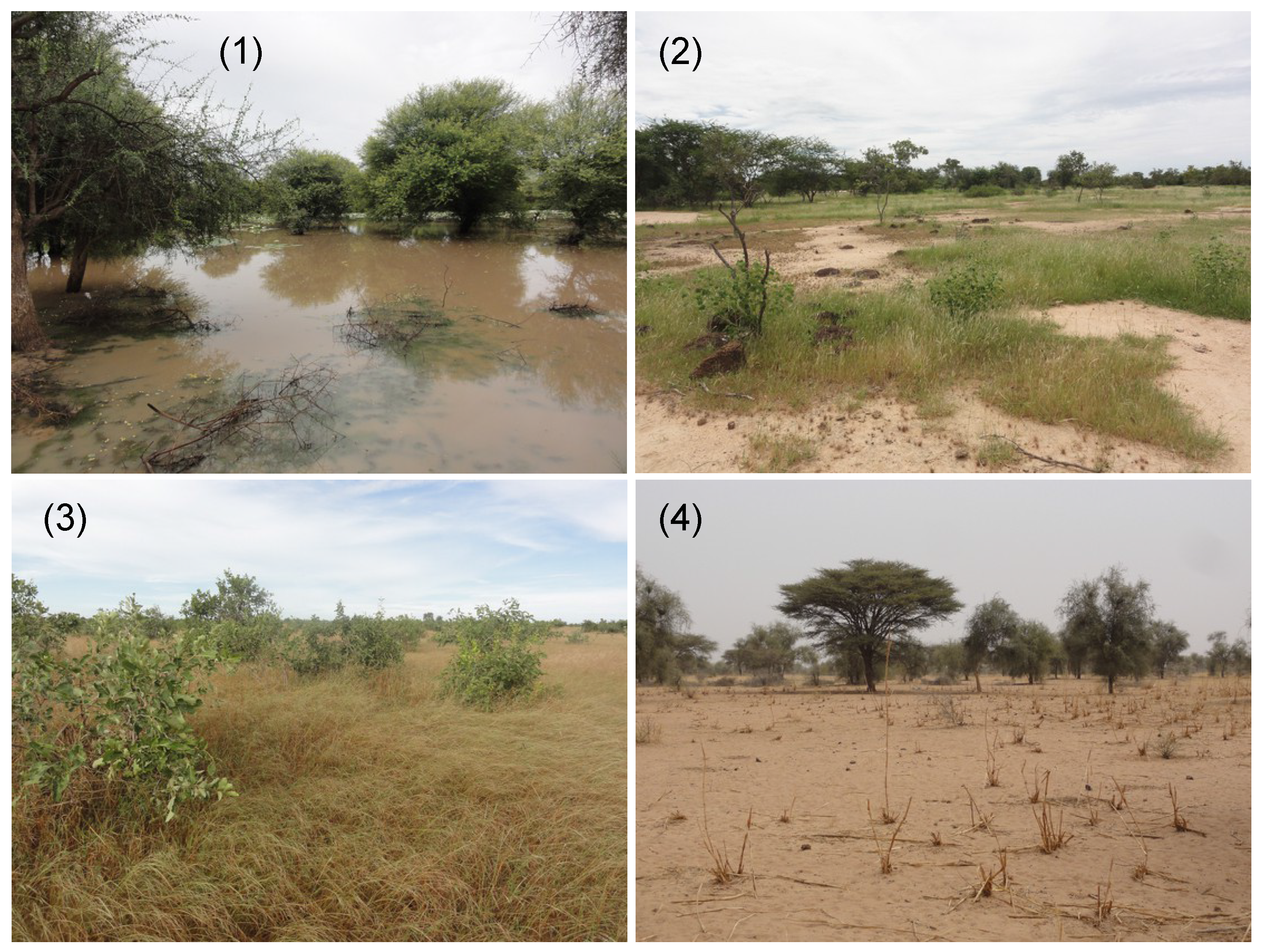
- According to interviewees, large parts of the natural vegetation on Dior and Bardial Arenosols were cleared by humans in the 20th century for the purpose of cropping and grazing. Areas formerly covered by dense and sometimes inaccessible bushland dominated by G. senegalensis and inhabited by wild animals were cleared. Only large trees or favored species (e.g., Faidherbia albida, A. nilotica, Acacia sieberiana, A. leiocarpus, Combretum nigricans, Lannea acida, S. setigera, T. avicennioides, Ziziphus mauritiana) were not felled. However, most of them exist only in very small numbers today (see Figure 8). Despite Arenosols having a large water storage capacity, which tempers the effects of dry years, some native species did not tolerate a general decrease in annual rainfall. Thus, local people report that the droughts in the 1970s and 1980s represent the starting point of a rapid increase of tree dying. Although a greening is observed which is caused by the woody layer [22], several species, which, according to village elders and older literature [13], were originally typical for this region and its soils, have now vanished (e.g., T. avicennioides). They have been replaced by three prevailing species (A. raddiana, B. aegyptiaca, C. glutinosum) which account for a share of over 90% on our Dior and Bardial test sites (see Figure 8). Although F. albida is a favored species and reported as being manifold on fields in former times, very few of these species larger than 4 m were found on Arenosols in 2012. However, various seedlings have been planted on cropland to reestablish F. albida, Z. mauritiana and other useful species as well as thousands of A. senegal on huge tree plantations. However, the seedlings are vulnerable to extreme events and livestock and are not able to grow without protection. Villages like Nguith (3 km west of Linguère) and Goloum have their own fenced areas where trees are planted and protected (Figure A2). Only villagers from the corresponding village are allowed to enter and practice sustainable farming.
3.5. Environmental Management Depends on Soil Types
4. Conclusions
Acknowledgments
Author Contributions
Conflicts of Interest
Appendix
| Variable | |
|---|---|
| pH | pH-value (H0) |
| EC | Electrical conductivity (µS/cm) |
| S | Sand in (%) |
| U | Silt in (%) |
| T | Clay in (%) |
| NO | Nitrate in (mg/kg) |
| NH | Ammonium in (mg/kg) |
| C/N | Carbon – Nitrogen ratio |
| N | Nitrogen in (% matter) |
| C | carbon in (% matter) |
| S | sulfur in (% matter) |
| H | hydrogenf in (% matter) |
| Ca | calcium in (cmol/kg) |
| Mg | magnesium in (cmol/kg) |
| Na | natrium in (cmol/kg) |
| K | potassium in (cmol/kg) |
| Al | aluminium in (cmol/kg) |
| Fe | iron in (cmol/kg) |
| density | density in (g/cm) |
| WcMax | maximum water holding capacity in (%) |
| Humus | humus in (%) |
| CECpot | potential cation exchange capacity in (cmol/kg) |
| BS | base saturation in (%) |
| STA | soil stability |
| CS | coarse sand in (%) |
| MS | medium sand in (%) |
| FS | fine sand in (%) |
| Parameter | |
|---|---|
| Trees/ha | 0.46 |
| Landsat Reflectance band 7 (REF 7) * | 0.42 |
| Landsat Reflectance band 5 (REF 5) * | 0.37 |
| Landsat Tasseled Cap Brightness (TC 1) * | 0.29 |
| Canopy cover (CAN COV) | 0.24 |
| DEM (SRTM) Altitude (ALT) * | 0.14 |
| Landsat NDVI * | 0.12 |
| Longitude (LONG) | 0.1 |
| Landsat Reflectance band 2 (REF2) * | 0.09 |
| Latitude (LAT) | 0.06 |
| TRMM annual rainfall | 0.045 |

| Dek | Bardial | Dior | Bowel | Class error | |
|---|---|---|---|---|---|
| Dek | 71 | 0 | 4 | 3 | 0.0897 |
| Bardial | 2 | 851 | 54 | 14 | 0.0760 |
| Dior | 0 | 35 | 743 | 9 | 0.0559 |
| Bowel | 0 | 21 | 17 | 355 | 0.0966 |

References
- Tappan, G.; Sall, M.; Wood, E.; Cushing, M. Ecoregions and land cover trends in Senegal. J. Arid Environ. 2004, 59, 427–462. [Google Scholar] [CrossRef]
- Brandt, M.; Romankiewicz, C.; Spiekermann, R.; Samimi, C. Environmental change in time series—An interdisciplinary study in the Sahel of Mali and Senegal. J. Arid Environ. 2014, 105, 52–63. [Google Scholar] [CrossRef]
- Reenberg, A.; Maman, I.; Bouzou Moussa, I.; Fog, B. Land saturation in SE Niger: Triangulating qualitative and quantitative information for critical assessment of land use trajectories. Land 2013, 2, 508–533. [Google Scholar] [CrossRef]
- Ali, A.; Lebel, T. The Sahelian standardized rainfall index revisited. Int. J. Climatol. 2009, 29, 1705–1714. [Google Scholar] [CrossRef]
- Herrmann, S.; Tappan, G. Vegetation impoverishment despite greening: A case study from central Senegal. J. Arid Environ. 2013, 90, 55–66. [Google Scholar] [CrossRef]
- Gonzalez, P. Desertification and a shift of forest species in the West African Sahel. Clim. Res. 2001, 17, 217–228. [Google Scholar] [CrossRef]
- Gonzalez, P.; Tucker, C.; Sy, H. Tree density and species decline in the African Sahel attributable to climate. J. Arid Environ. 2012, 78, 55–64. [Google Scholar] [CrossRef]
- Vincke, C.; Diédhiou, I.; Grouzis, M. Long term dynamics and structure of woody vegetation in the Ferlo (Senegal). J. Arid Environ. 2010, 74, 268–276. [Google Scholar] [CrossRef]
- Herrmann, S.; Hutchinson, C. The changing contexts of the desertification debate. J. Arid Environ. 2005, 63, 538–555. [Google Scholar] [CrossRef]
- Ndour, T. La Degradation des sols au Sénégal: l’Exemple de deux Communautés Rurales. Ph.D. Thesis, Université Cheikh Anta Diop, Dakar, Senegal, 2001. [Google Scholar]
- Maydell, H.J.V. Trees and Shrubs of the Sahel: Their Characteristics and Uses; Verlag Josef Margraf: Weikersheim, Germany, 1990. [Google Scholar]
- Lawesson, J.E. Sahelian woody vegetation in Sénégal. Vegetatio 1990, 86, 161–174. [Google Scholar] [CrossRef]
- Adam, J. Généralités sur la flore et la vegetation du Senegal = Études Sénégalaises N°9. Connaissance du Sénégal Fascicule III: Climat-Sols-Végétation; Centre de Recherches et de Documentation du Sénégal: Saint-Louis, Senegal, 1965. [Google Scholar]
- Charreau, C.; Fauck, R. Les sols du Senegal = Études Sénégalaises N°9. Connaissance du Sénégal Fascicule III: Climat-Sols-Végétation; Centre de Recherches et de Documentation du Sénégal: Saint-Louis, Senegal, 1965. [Google Scholar]
- Maignien, R. Carte pédologique du Sénégal; Office de la Recherche Scientifique et Technique Outre-Mer: Dakar-Hann, Senegal, 1965. [Google Scholar]
- Stancioff, A.S. Cartographie et Teledetection des Ressources de la Republique du Senegal; Remote Sensing Institute, South Dakota State University: Brookings, SD, USA, 1986. [Google Scholar]
- Miehe, S.; Kluge, J.; von Wehrden, H.; Retzer, V. Long-term degradation of Sahelian rangeland detected by 27 years of field study in Senegal. J. Appl. Ecol. 2010, 47, 692–700. [Google Scholar] [CrossRef]
- Centre de Suivi Ecologique (CSE). Evaluation Locale de la Degradation des Terres—Rapport G.A.A. de Barkedji; Technical Report PR 41683; CSE: Dakar, Senegal, 2009. [Google Scholar]
- ROSELT. La Surveillance Environnementale dans L’observatoire ROSELT/OSS du Ferlo; Rapport scientifique 2003-2005; Centre de Suivi Ecologique: Dakar, Senegal, 2005. [Google Scholar]
- Strommer, G.; Brandt, M.; Diongue-Niang, A.; Samimi, C. Analysis of daily rainfall of the Sahelian weather-station Linguère (Senegal)—Trends and its impacts on the local population. In Proceedings of the EGU General Assembly Conference Abstracts, Vienna, Austria, 7–12 April 2013; Volume 15, p. 12716.
- Diouf, A.; Lambin, E.F. Monitoring land-cover changes in semi-arid regions: Remote sensing data and field observations in the Ferlo, Senegal. J. Arid Environ. 2001, 48, 129–148. [Google Scholar] [CrossRef]
- Brandt, M.; Verger, A.; Diouf, A.A.; Baret, F.; Samimi, C. Local vegetation trends in the Sahel of Mali and Senegal using long time series FAPAR satellite products and field measurement (1982–2010). Remote Sens. 2014, 6, 2408–2434. [Google Scholar] [CrossRef]
- Duvall, C.S. Classifying physical geographic features: The case of Maninka farmers in southwestern Mali. Geogr. Ann.: Ser. B Hum. Geogr. 2008, 90, 327–348. [Google Scholar] [CrossRef]
- Ndiaye, M. Systemes de Production et Mutations des Paysages Ruraux dans la Basse Vallee du Ferlo au Senegal. Ph.D. Thesis, Université de Bordeaux III, Bordeaux, France, 2007. [Google Scholar]
- Herrick, J.E.; Jornada Experimental Range. Monitoring Manual for Grassland, Shrubland, and Savanna Ecosystems; USDA-ARS Jordana Experimental Range; University of Arizona Press: Las Cruces, NM, USA/Tucson, AZ, USA, 2005. [Google Scholar]
- Stocking, M.A.; Murnaghan, N. A Handbook for the Field Assessment of Land Degradation; Routledge: New York, NY, USA, 2001. [Google Scholar]
- Sponagel, H. Ad-hoc-Arbeitsgruppe Boden der staatlichen geologischen Dienste und der Bundesanstalt für Geowissenschaften und Rohstoffe. In Bodenkundliche Kartieranleitung: Mit 103 Tabellen; Schweizerbart: Stuttgart, Germany, 2005; p. 473. [Google Scholar]
- Blume, H.P.; Stahr, K.; Leinweber, P. Bodenkundliches Praktikum: Eine Einführung in Pedologisches Arbeiten für Ökologen, Land- und Forstwirte, Geo- und Umweltwissenschaftler; Spektrum Akademischer Verlag: Heidelberg, Germany, 2010. [Google Scholar]
- Grau, T. Die Bodenqualität in der Ferlo-Region (Senegal) in Abhängigkeit von den Raum-und Nutzungsparametern. Master’s Thesis, University of Vienna, Vienna, Austria, 2013. [Google Scholar]
- Landon, J.R.; Booker Agriculture International Limited. Booker Tropical Soil Manual: A Handbook for Soil Survey and Agricultural Land Evaluation in the Tropics and Subtropics; Routledge: New York, NY, USA, 1991. [Google Scholar]
- Brenning, A. Benchmarking classifiers to optimally integrate terrain analysis and multispectral remote sensing in automatic rock glacier detection. Remote Sens. Environ. 2009, 113, 239–247. [Google Scholar] [CrossRef]
- Ward, J.H. Hierarchical grouping to optimize an objective function. J. Am. Stat. Assoc. 1963, 58, 236–244. [Google Scholar] [CrossRef]
- Borg, I.; Groenen, P.J.F. Modern Multidimensional Scaling: Theory and Applications; Springer: New York, NY, USA, 2007. [Google Scholar]
- Duvall, C.S. Biocomplexity from the ground up: Vegetation patterns in a West African savanna landscape. Ann. Assoc. Am. Geogr. 2011, 101, 497–522. [Google Scholar] [CrossRef]
- Huffman, G.J.; Bolvin, D.T.; Nelkin, E.J.; Wolff, D.B.; Adler, R.F.; Gu, G.; Hong, Y.; Bowman, K.P.; Stocker, E.F. The TRMM Multisatellite Precipitation Analysis (TMPA): Quasi-global, multiyear, combined-sensor precipitation estimates at fine scales. J. Hydrometeorol. 2007, 8, 38–55. [Google Scholar] [CrossRef]
- Hildebrandt, G. Fernerkundung und Luftbildmessung: für Forstwirtschaft, Vegetationskartierung und Landschaftsökologie; Wichmann: Heidelberg, Germany, 1996. [Google Scholar]
- Kauth, R.J.; Thomas, G.S. The tasselled cap—A graphic description of the spectral-temporal development of agricultural crops as seen by Landsat. In Proceedings of the Symposium on Machine Processing of Remotely Sensed Data, West Lafayette, IN, USA, June 29–July 11976; p. 159.
- Breiman, L. Random Forests. Mach. Learn. 2001, 45, 5–32. [Google Scholar] [CrossRef]
- Lawrence, R.L.; Wood, S.D.; Sheley, R.L. Mapping invasive plants using hyperspectral imagery and Breiman Cutler classifications (randomForest). Remote Sens. Environ. 2006, 100, 356–362. [Google Scholar] [CrossRef]
- Pal, M. Random forest classifier for remote sensing classification. Int. J. Remote Sens. 2005, 26, 217–222. [Google Scholar] [CrossRef]
- Larsson, H. Linear regressions for canopy cover estimation in Acacia woodlands using Landsat-TM, -MSS and SPOT HRV XS data. Int. J. Remote Sens. 1993, 14, 2129–2136. [Google Scholar] [CrossRef]
- Food & Agriculture Organization (FAO). Guidelines for Soil Description; FAO: Rome, Italy, 2006. [Google Scholar]
- Sarr, M.A. Cartographie des changements de l’occupation du sol entre 1990 et 2002 dans le nord du Sénégal (Ferlo) à partir des images Landsat. Cybergeo: Eur. J. Geogr. 2009, 472, 1–38. [Google Scholar] [CrossRef]
© 2014 by the authors; licensee MDPI, Basel, Switzerland. This article is an open access article distributed under the terms and conditions of the Creative Commons Attribution license (http://creativecommons.org/licenses/by/3.0/).
Share and Cite
Brandt, M.; Grau, T.; Mbow, C.; Samimi, C. Modeling Soil and Woody Vegetation in the Senegalese Sahel in the Context of Environmental Change. Land 2014, 3, 770-792. https://doi.org/10.3390/land3030770
Brandt M, Grau T, Mbow C, Samimi C. Modeling Soil and Woody Vegetation in the Senegalese Sahel in the Context of Environmental Change. Land. 2014; 3(3):770-792. https://doi.org/10.3390/land3030770
Chicago/Turabian StyleBrandt, Martin, Tobias Grau, Cheikh Mbow, and Cyrus Samimi. 2014. "Modeling Soil and Woody Vegetation in the Senegalese Sahel in the Context of Environmental Change" Land 3, no. 3: 770-792. https://doi.org/10.3390/land3030770
APA StyleBrandt, M., Grau, T., Mbow, C., & Samimi, C. (2014). Modeling Soil and Woody Vegetation in the Senegalese Sahel in the Context of Environmental Change. Land, 3(3), 770-792. https://doi.org/10.3390/land3030770