1. Introduction
Vernacular settlements represent more than inherited architectural forms. They embody relationships among climate, local resources, spatial organization, cultural practices, and everyday life. In this study, vernacular heritage is understood as the combined tangible and intangible legacy of environments shaped through local knowledge and collective adaptation. Tangible dimensions include buildings, streets, walls, gates, water systems, materials, and architectural details. Intangible dimensions include traditional skills, social customs, privacy practices, communal use, and environmental knowledge [
1,
2,
3]. Their significance therefore lies not only in age or appearance. It also lies in their contribution to identity, environmental adaptation, social continuity, and contemporary development.
Heritage value is not treated as an intrinsic quality that automatically resides in historic fabric. Instead, it refers to the significance attributed to a place, material, spatial arrangement, practice, association, or form of knowledge by particular individuals and groups. These meanings are shaped by social, cultural, environmental, and institutional conditions [
4,
5,
6,
7,
8]. A physical feature may support several forms of value. A narrow alley may provide shade and pedestrian access. It may also support privacy, social interaction, memory, and architectural character. These meanings can overlap or change over time. They may also conflict with current requirements for accessibility, safety, infrastructure, economic use, and visitor activity.
The study is principally grounded in the values-based conservation approach developed by the Getty Conservation Institute and Mason [
4,
5]. This position is supported by Riegl’s recognition of coexisting and potentially conflicting heritage values [
6] and the Burra Charter’s understanding of plural cultural significance [
7]. It also responds to Fredheim and Khalaf’s critique of rigid value typologies [
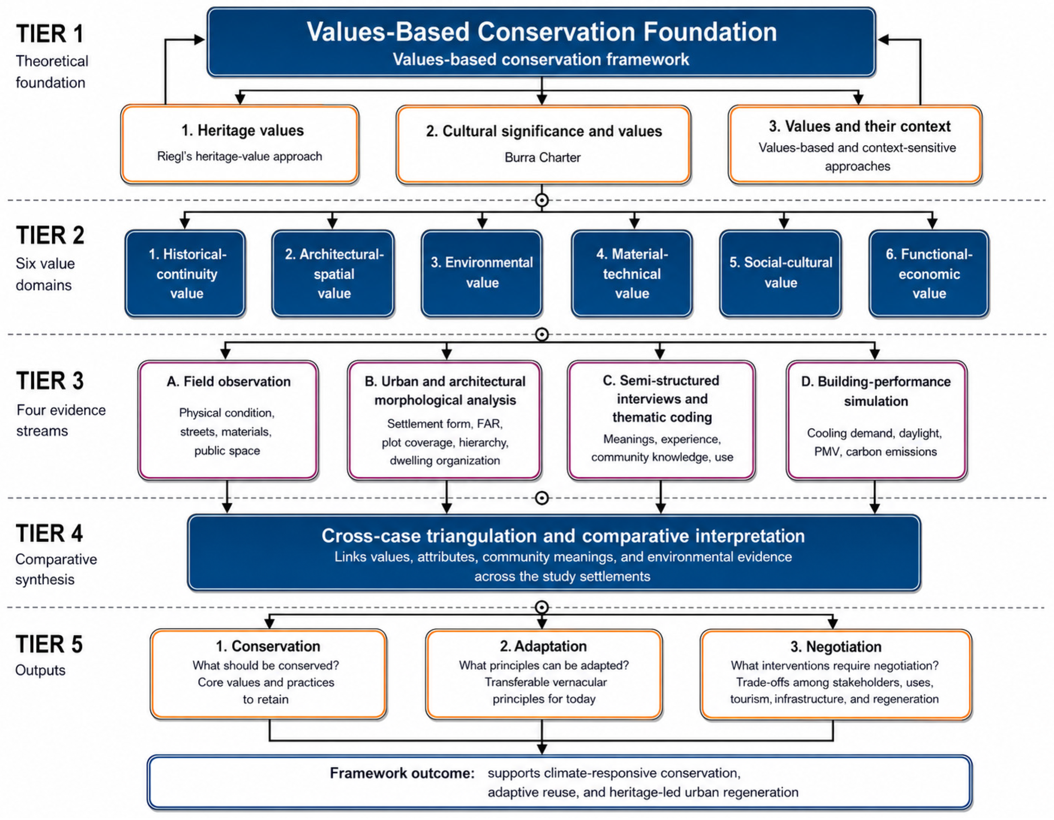
8]. Accordingly, heritage significance is examined through six interconnected domains: historical-continuity, architectural-spatial, environmental, material-technical, social-cultural, and functional-economic value. These domains are used as overlapping analytical lenses rather than fixed or mutually exclusive categories.
This interpretation is especially relevant in hot-arid regions. Communities historically moderated climatic extremes through compact urban forms, shaded routes, attached buildings, thick earthen envelopes, controlled openings, terraces, and seasonally adapted occupation [
9,
10,
11,
12]. These features worked through relationships among density, street enclosure, thermal mass, orientation, ventilation, privacy, and daily routines. Vernacular settlements therefore contain environmental knowledge that remains relevant to energy use, thermal stress, carbon emissions, and climate-responsive development.
Climate-responsive conservation is defined here as an approach that protects material authenticity, cultural significance, and social meaning while sustaining environmental knowledge embedded in spatial and construction systems. It differs from strategies focused mainly on visual restoration or façade treatment. Instead, it considers how morphology, materials, openings, shading, ventilation, and patterns of use contribute to environmental moderation. It also considers how these qualities may be retained or responsibly adapted [
10,
13]. This approach does not seek to freeze settlements in an earlier condition. Nor does it support the literal reproduction of historic forms. It aims to conserve significant attributes while allowing carefully evaluated responses to safety, accessibility, infrastructure, comfort, and viable use.
This need is evident in Oman. Rapid development and metropolitan expansion have transformed relationships among dwellings, streets, and communities. Contemporary residential development is often characterized by detached villas, extensive setbacks, wide roads, reinforced-concrete construction, private-vehicle dependence, and intensive mechanical cooling [
14,
15,
16,
17]. These patterns differ from the compactness, mixed functions, pedestrian connectivity, material economy, and layered public–private relationships of historic settlements. At the same time, abandonment, deterioration, incompatible repairs, and declining transmission of construction skills threaten both earthen fabric and community knowledge.
Conservation of individual buildings alone cannot restore the vitality of a historic settlement. Urban regeneration is therefore understood as a coordinated process that seeks sustained physical, social, environmental, and economic improvement rather than isolated repair [
18]. In heritage settings, regeneration may involve adaptive reuse, renewed occupation, public-space improvement, local enterprise, community participation, infrastructure upgrading, and visitor management. However, reuse may also create pressure through commercialization, excessive tourism, material alteration, residential displacement, and loss of privacy [
19,
20]. Regeneration must therefore identify which values should be conserved, which vernacular principles may be adapted, and which interventions require negotiation among stakeholders.
Existing scholarship has established the climatic relevance of vernacular morphology and materials. It has also examined the influence of cultural practices on domestic space and the sustainability potential of compact settlement structures [
9,
10,
11,
12,
21,
22,
23]. However, these dimensions are often studied separately. Less attention has been given to how tangible attributes, intangible knowledge, environmental performance, stakeholder meanings, and regeneration priorities can be interpreted within one comparative framework.
This study addresses that gap by conducting a comparative analysis of two historic settlements and one contemporary neighbourhood in Oman. It asks: How can the tangible and intangible values of vernacular settlements be identified and comparatively interpreted to inform climate-responsive conservation, adaptive reuse, and urban regeneration in contemporary Oman? The study combines morphological analysis, field documentation, semi-structured interviews, and building-performance simulation. Its purpose is not to validate a universal heritage-value typology. Instead, it applies a context-specific framework to clarify relationships among heritage significance, environmental performance, community knowledge, and contemporary intervention.
3. Materials and Methods
3.1. Case-Study Selection
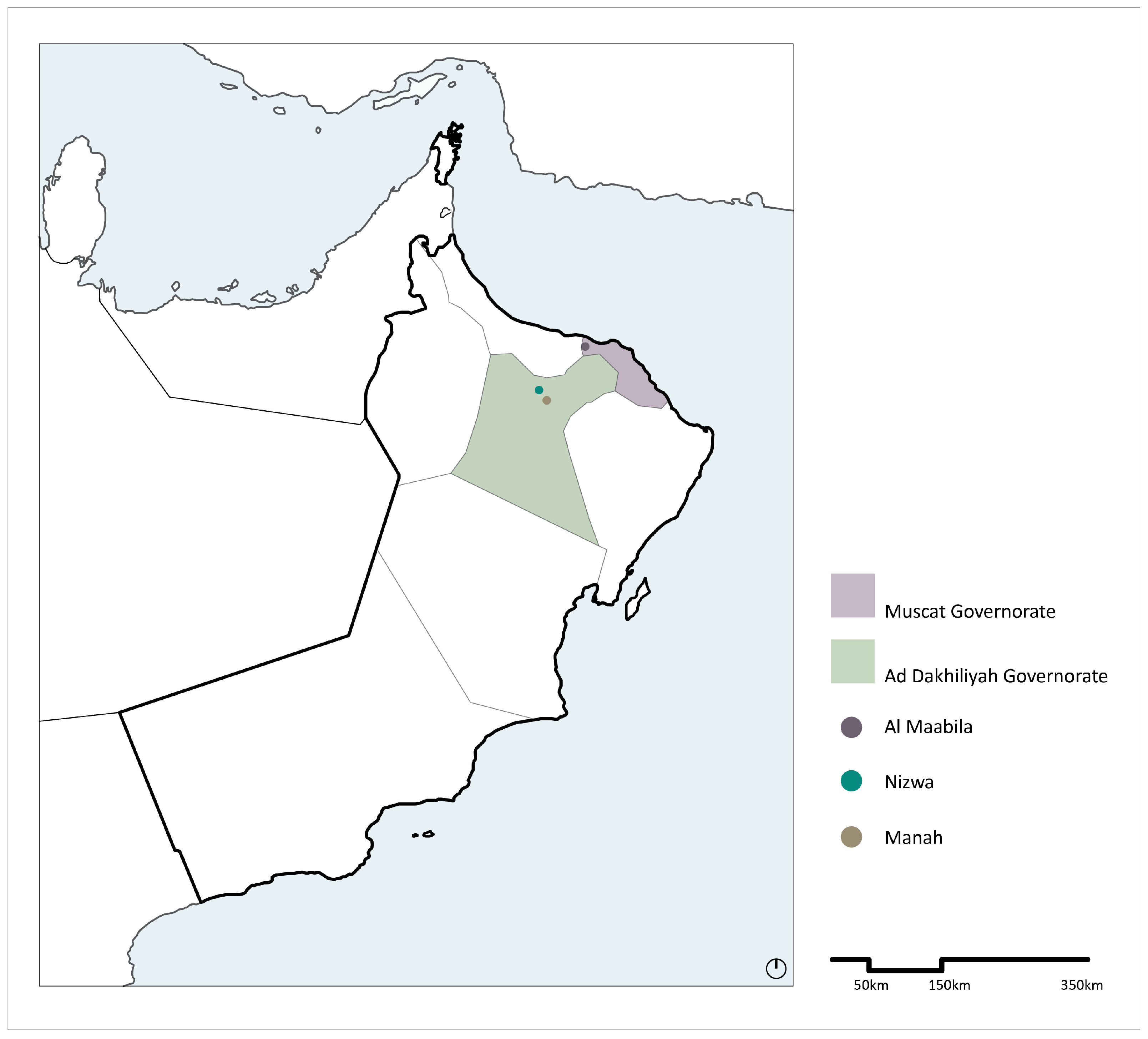
The study used purposive comparative case selection rather than statistical sampling. Three settlements were selected because they represent contrasting but complementary conditions within Oman. Harat Al Aqr in Nizwa represents a historic settlement characterized by community-led regeneration, adaptive reuse, tourism activity, and continued occupation. Harat Al Bilad in Manah represents a historic earthen settlement undergoing institution-led conservation but with limited occupation and economic activation. Al Maabilah in Al Seeb provides a contemporary reference for examining changes in density, plot coverage, street form, public space, dwelling organization, construction materials, accessibility, and energy demand. The locations of the three case-study areas are presented in
Figure 2.
The cases also occupy different demographic and environmental contexts. The Greater Nizwa planning area covers approximately 370 km
2 and includes Nizwa together with parts of Manah and Birkat Al Mouz [
74]. In 2023, Nizwa Wilayat had approximately 148,182 residents, while Manah had approximately 28,299 residents [
75]. Al Seeb had approximately 543,423 residents during the same period [
75]. Its population density reached approximately 1111 persons per km
2 in 2023 [
76]. These administrative statistics provide contextual information and do not represent the populations contained within the smaller case-study boundaries.
Nizwa and Manah are located in Oman’s hot and dry interior. Oasis agriculture, aflaj, wells, earthen walls, stone, and timber-and-earth roofs historically influenced their settlement morphology and construction systems. Al Maabilah is located in the hot-humid coastal environment of Al Seeb. Metropolitan expansion, reinforced-concrete construction, detached villas, wider roads, and extensive setbacks are more prominent in this area [
77]. The comparative selection therefore captures differences in climate, settlement morphology, material systems, occupation, governance, and regeneration status. It also allows the two historic settlements to be examined against a contemporary neighbourhood rather than being treated in isolation.
3.2. Research Design
The study adopted a comparative mixed-method case-study design to examine vernacular heritage as an integrated system of physical form, material knowledge, environmental performance, and community experience. It combined field observation and photography, urban and architectural morphological analysis, semi-structured interviews, and comparative building-performance simulation. These methods were selected because no single source of evidence could adequately explain the multiple forms of significance embodied in vernacular settlements.
The research followed a sequential process. The literature review first identified relevant heritage and climate-responsive attributes. These included compact form, connected shade, building attachment, street enclosure, controlled openings, thermal mass, privacy gradients, shared infrastructure, and communal space. Three contrasting settlements were then selected to represent different relationships among heritage status, morphology, conservation, occupation, and contemporary development.
Field and documentary evidence was organized at neighbourhood and building scales. Interview narratives were thematically coded and linked to observable spatial and material features. Representative dwellings were modelled in DesignBuilder using the EnergyPlus simulation engine. The qualitative, morphological, and simulation findings were then triangulated to identify convergences, contradictions, and implications for conservation and urban regeneration.
Heritage-value identification followed a two-stage process informed by values-based conservation principles [
4,
5,
7]. First, physical, spatial, material, environmental, functional, and social attributes were documented. Second, these attributes were interpreted through participants’ meanings, uses, associations, experiences, and conservation priorities. Physical presence or measured performance alone was therefore not treated as sufficient evidence of heritage value.
Table 1 summarizes the data sources, recorded and derived variables, and principal analytical outputs used in the comparative research design.
3.3. Units of Analysis and Representative Dwelling Selection
The analysis was conducted at two interconnected scales. At the neighbourhood scale, the units of analysis included blocks, plots, streets, access routes, building footprints, land-use functions, communal facilities, public–private circulation patterns, and shading elements. The principal indicators included floor-area ratio, plot coverage, building continuity, street width, building height, street width-to-height relationship, block grain, route connectivity, distribution of functions, pedestrian access, and continuity of shade.
At the architectural scale, the analysis examined representative dwelling typologies, including internal functional distribution, number of storeys, built-up area, relationship to plot boundaries, open and semi-open spaces, envelope construction, roof assembly, window and door dimensions, opening placement, and ventilation opportunities. Four dwelling types were selected: a row dwelling in Harat Al Aqr, a terrace-oriented dwelling in Harat Al Bilad, a detached single villa in Al Maabilah, and a twin villa in Al Maabilah.
The dwellings were purposively selected according to four criteria: their representativeness of the predominant local typology; the availability of reliable plans, measurements, and photographic documentation; sufficient physical integrity to reconstruct their spatial organization; and suitability for comparison through building-performance modelling. The sample was not intended to represent every dwelling in each settlement. Instead, it provided a controlled typological comparison through which the relationships among form, material, exposure, openings, and environmental performance could be explored.
3.4. Field Documentation and Morphological Analysis
Primary fieldwork combined direct observation, measurements, photography, and interviews. Street documentation recorded route width, approximate building height, orientation, enclosure, surface materials, pedestrian conditions, and the presence of connected shading elements such as arcades, projections, walls, and vegetation. Building documentation recorded dwelling form, number of storeys, internal organization, plot occupation, façade composition, opening dimensions and placement, wall materials, surface finishes, roof construction, terraces, wells, and evidence of deterioration or later intervention.
The field record was supplemented by existing plans, cadastral information where available, satellite imagery, and drawings prepared during the research project. Spatial information was digitized and organized using consistent categories for streets, plots, building masses, walls, gates, vegetation, communal facilities, and land uses. Floor-area ratio was used to compare built intensity, while plot coverage and building attachment helped distinguish compact heritage fabrics from detached contemporary development. Accessibility analysis differentiated primary routes, secondary routes, private or semi-private alleys, pedestrian circulation, and rooftop movement where historically documented.
Photographic documentation was treated as analytical evidence rather than illustration alone. Images were selected to substantiate observations about street enclosure, material condition, openings, thresholds, roof structures, water systems, pedestrian exposure, adaptive reuse, and conservation interventions. Plans, maps, photographs, and measured observations were subsequently cross-checked to reduce dependence on a single source.
3.5. Interview Data and Thematic Analysis
Semi-structured interviews targeted local community members, visitors, property owners, managers, and settlement representatives with direct knowledge of living in, using, managing, conserving, or operating activities within the three cases. Participants were recruited through purposive, availability-based stakeholder sampling. Inclusion required direct experience of the relevant settlement and voluntary consent; individuals without direct case knowledge or complete interview records were excluded. The retained dataset comprised three consolidated case-specific interview records, one each for Harat Al Aqr, Harat Al Bilad, and Al Maabilah.
The semi-structured guide covered urban functions, public-space use, dwelling organization, accessibility, climatic experience, materials, water infrastructure, privacy, cultural practices, conservation, tourism, and neighbourhood change. The semi-structured interview guide contained 19 questions for each settlement, covering urban form, accessibility, materials, cultural practices, conservation, and neighbourhood change. The estimated duration of each interview was 35–45 min, with an approximate average of 40 min. Records were thematically coded and compared across cases. Interview evidence was used to interpret documented spaces and practices rather than as statistically representative evidence. Participants consented to publication provided that their identities remained confidential. Quotations were anonymized and limited to themes relevant to the analysis.
3.6. Building-Performance Simulation
Building-scale environmental performance was assessed using DesignBuilder, which was used to generate and execute the corresponding EnergyPlus simulations. Separate models were created for four representative dwelling types: a row dwelling in Harat Al Aqr, a terrace-oriented dwelling in Harat Al Bilad, a detached single villa in Al Maabilah, and a twin villa in Al Maabilah. Geometry was reconstructed from available plans, field measurements, photographs, and documented building characteristics.
The models represented differences in built form, building attachment, exposed façade area, wall and roof construction, glazing, opening dimensions, internal organization, and HVAC provision. Neighbouring buildings and overhangs were also modelled to account for their influence on shading and solar exposure. Party walls in the historic dwellings were assigned adiabatic boundary conditions where adjoining construction limited external heat transfer.
The principal outputs were annual cooling-energy use intensity, cooling demand during the summer design week, average daylight factor, predicted mean vote, and carbon emissions. These indicators were selected to distinguish energy demand, conditioned thermal comfort, daylight availability, and environmental impact rather than combining them into a single measure of performance.
The vernacular dwellings were modelled using natural-ventilation assumptions, while the contemporary villas were modelled with split mechanical-cooling systems. Because these operational conditions differ, comparisons were interpreted as typological and performance-based contrasts rather than as identical-system tests. The models were used to identify relative differences associated with form, materials, exposure, openings, and conditioning strategy. They should not be interpreted as monitored measurements of actual occupied buildings.
The complete simulation settings are reported in
Appendix A,
Table A1. These include the software versions, weather file, simulation period, material properties, infiltration rate, occupancy assumptions, lighting and equipment gains, HVAC settings, daylight parameters, carbon-emission factor, and calibration status. Since long-term monitored data were unavailable, the simulations were not calibrated against actual energy use or indoor environmental measurements. The outputs were therefore used for comparative interpretation rather than precise prediction of occupied-building performance.
3.7. Triangulation, Ethics, and Methodological Boundaries
Triangulation was undertaken by comparing field measurements, maps, photographs, interviews, and simulation outputs. A finding was considered more strongly supported when multiple forms of evidence converged. Divergent evidence was retained rather than removed; for example, lower simulated cooling demand was distinguished from improved mechanically conditioned comfort, and perceived shaded comfort was not presented as measured outdoor thermal comfort.
Interview participation was voluntary and identities were anonymized. Digital records were stored securely. The research design nevertheless has boundaries: the cases were purposively selected, the interview corpus was qualitative, and the building models were not supported by long-term monitored calibration data. These methodological boundaries were considered during interpretation, and the findings were treated as context-specific comparative evidence rather than statistically generalizable conclusions.
4. Results
4.1. Settlement Morphology, Land-Use Integration, and Built Intensity
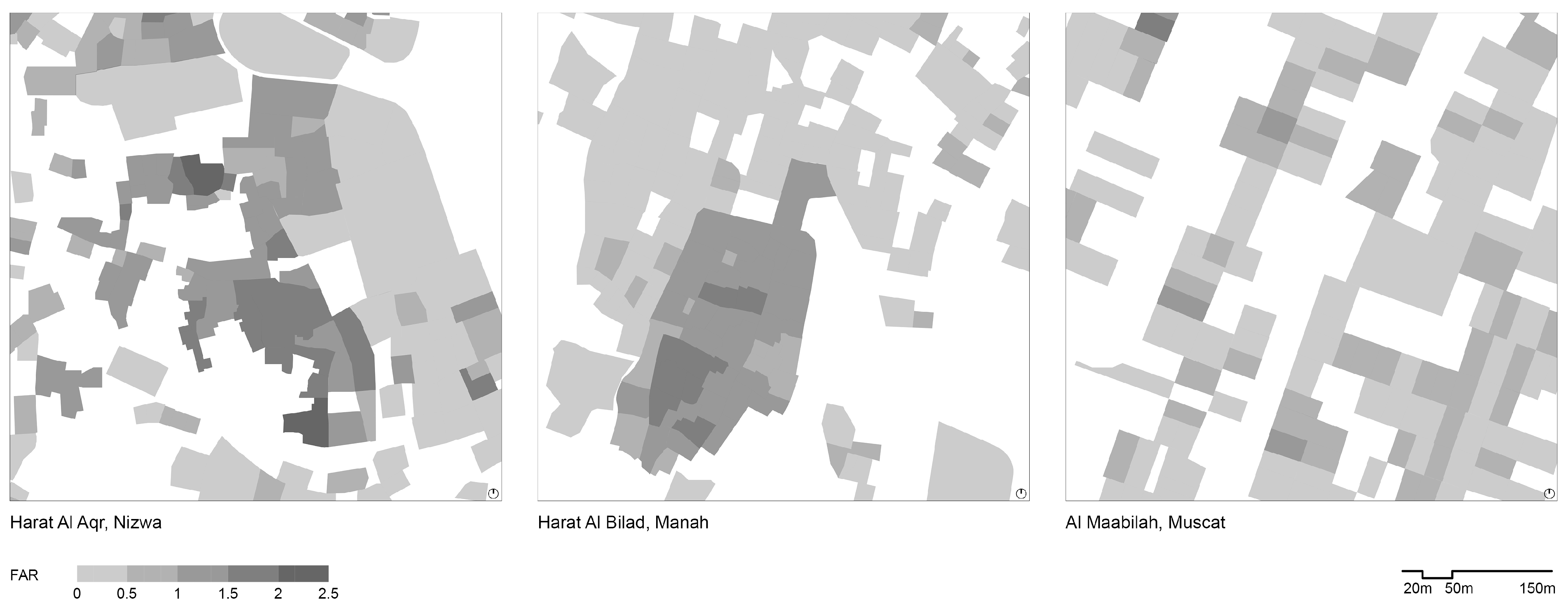
The spatial analysis identified substantial differences in land-use distribution, built intensity, street enclosure, and the relationship between individual dwellings and the wider settlement. The historic settlements predominantly comprised attached or closely spaced buildings, limited setbacks, narrow circulation routes, and fine-grained combinations of residential and community functions. The floor-area-ratio patterns presented in
Figure 3 provide the clearest initial indication of these differences. Harat Al Aqr generally recorded FAR values of approximately 1.5–2 within the denser residential core despite the modest height of most buildings. Harat Al Bilad commonly recorded FAR values of approximately 1–1.5, with selected areas approaching 2. These values resulted from extensive plot occupation, shared party walls, minimal separation between adjoining buildings, and two-storey construction. By contrast, much of Al Maabilah recorded FAR values between 0 and 0.5.
A participant from Nizwa explained that the settlement developed incrementally in response to community needs and that residents “built everything they needed” within the neighbourhood. In Manah, compact forms were similarly associated with self-sufficiency and protection. A participant described the settlement as “surrounded by agricultural fields from every direction,” with locally produced goods and services located within or adjacent to the fortified boundary. The Al Maabilah participant instead described the neighbourhood as car-dependent because “everything is far away.”
“…They lived like one large community and shared almost everything. They used the souq to sell their own products and goods, and every house had at least one or two wells as its main source of water, while the falaj supported agriculture. The neighbourhood was improved to suit the residents’ needs, and the gates closed at six in the evening and reopened in the morning to maintain safety, privacy, and protection.”
(Respondent from Harat Al Aqr, Nizwa)
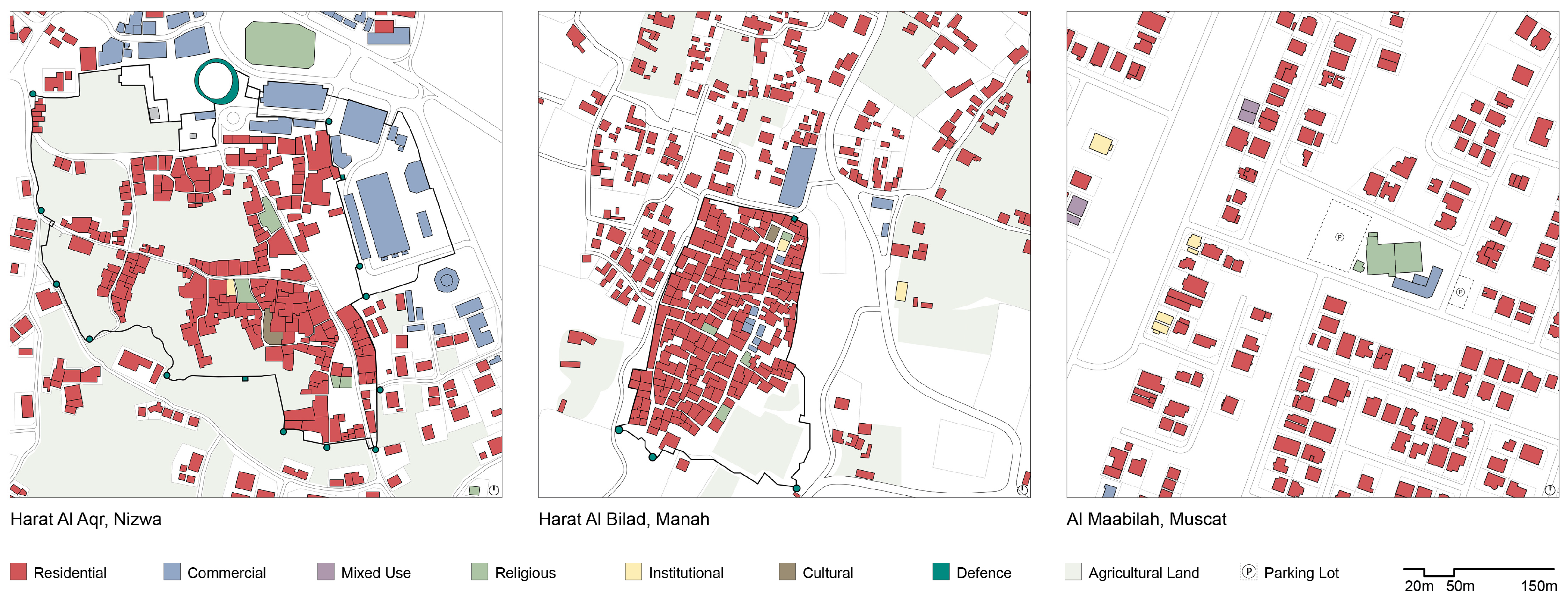
The land-use patterns shown in
Figure 4 demonstrate a corresponding difference in the spatial distribution of activities. Harat Al Aqr integrated residential buildings, mosques, a madrasa, majlis spaces, the souq, defensive structures, and agricultural land. Harat Al Bilad contained residential, religious, civic, commercial, defensive, and agricultural functions. Al Maabilah also contained a mixture of functions, including mosques, educational and health facilities, food businesses, parks, apartments, and shops, but commercial activity was concentrated primarily along the main road.
The Nizwa interviewee described the settlement as consisting of residential units of different sizes, mosques, a madrasa, and majlis spaces, all connected to defensive features, the souq, and agricultural land. The participant stated that these functions “were developed based on the residents’ needs.” The Manah interviewee similarly emphasized a functional hierarchy organized around public and private routes. The main road contained shops, mosques, and resting spaces, while private alleys served households and provided more controlled communal space.
“…It consisted mainly of residential units that varied in size, mosques, a madrasa, and majlis for cultural and social gatherings. All of these functions were surrounded by elements of defence, the fort and observation towers, the souq, and agricultural lands. All of these functions were developed based on the residents’ needs.”
(Respondent from Harat Al Aqr, Nizwa)
“…Harat Al Bilad consisted of two main types of streets: the main public road, which contained all of the shops, mosques, and resting areas, and the private narrow alleyways, or sikka, which acted as entrance paths to the houses and served as private communal areas for women.”
(Respondent from Harat Al Bilad, Manah)
In Al Maabilah, the participant acknowledged the diversity of functions but explained that “most of the commercial activities” occurred linearly along the primary road. Residential areas were farther inside, and small-scale services were unevenly distributed among neighbourhood centres. This meant that functional diversity at the district scale did not necessarily create pedestrian accessibility at the neighbourhood scale.
The combined FAR and land-use findings are summarized in
Table 2. First, compact historic forms supported greater land-use proximity and higher built intensity without requiring tall buildings. Second, the contemporary neighbourhood’s larger plots and wider roads separated activities and increased dependence on motorized travel. Third, the relationship between morphology and function was inseparable from social use. In the historic settlements, streets, squares, gates, mosques, markets, ovens, wells, and agricultural edges formed an interconnected system. In the contemporary neighbourhood, similar functions existed but were more spatially separated.
4.2. Living Heritage, Compact Form, and Community-Led Regeneration
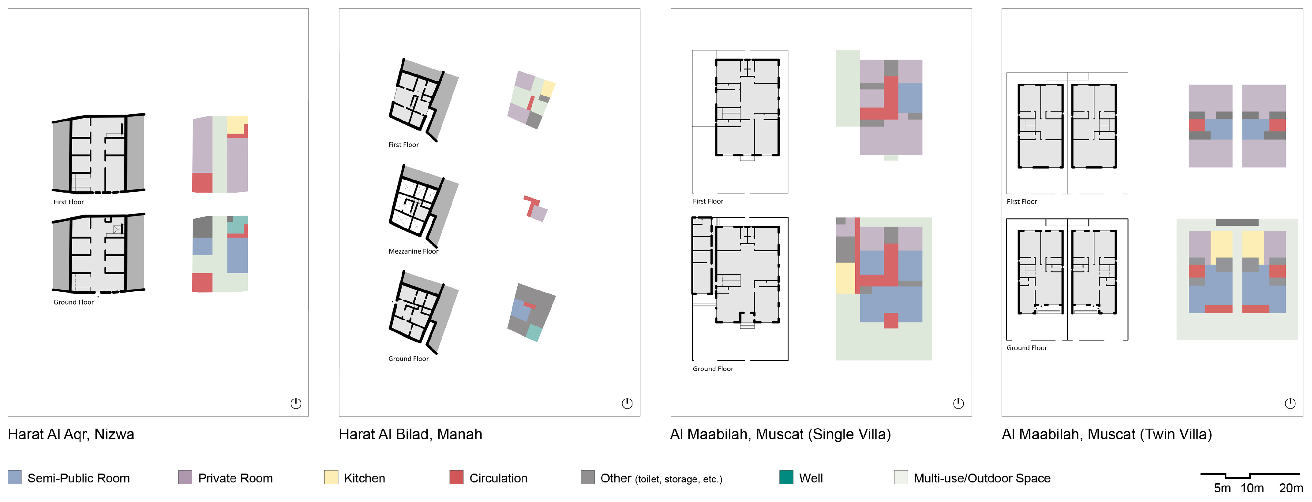
The representative dwelling plans presented in
Figure 5 show how neighbourhood morphology was reproduced at the architectural scale. In Harat Al Aqr, the selected dwelling formed part of an attached row-house structure. The ground floor accommodated semi-public, storage, well, and service functions, while bedrooms and the kitchen occupied the upper floor. In Harat Al Bilad, the representative dwelling included ground-floor storage, animal space, a well, washing facilities, a latrine, and communal areas. Some houses also incorporated a mezzanine. Private rooms, the kitchen, grain storage, and family gathering spaces were generally positioned upstairs around a terrace.
The vertical distribution of functions served several purposes simultaneously. Ground-floor washing spaces remained close to wells, kitchens on upper floors enabled smoke and heat to escape more readily, and bedrooms were separated from semi-public entrances and guest areas. In Nizwa, the participant noted that the kitchen was located upstairs “to aid in ventilating during wood cooking.” The toilet was also placed on the upper level to facilitate cleaning and waste disposal, whereas showers remained below near the water source.
“…The kitchen was primarily located on the first floor to aid ventilation during wood cooking. The toilet, known as the Shrooni, was on the first floor to facilitate waste disposal and easy cleaning. Showers were situated on the ground floor for convenient access to water from the wells or falaj systems.”
(Respondent from Harat Al Aqr, Nizwa)
The contemporary single and twin villas retained a vertical separation between semi-public and private functions but did so within detached plot-based forms. The ground floor generally contained living spaces, majlis rooms, kitchens, storage, guest rooms, offices, and bathrooms, while bedrooms and a family living area were located upstairs. A participant summarized the organization as the ground floor being “more used as a communal space and for services,” while the upper level contained bedrooms.
The dwelling plans also revealed different relationships with outdoor space. The Nizwa row house had little or no private ground-level outdoor area because most of the plot was occupied. Manah dwellings more commonly used an upper-level terrace as a protected open space. In Al Maabilah, outdoor space was created through mandatory setbacks, but these areas were often used for parking rather than as climatically comfortable gardens or communal rooms.
The Al Maabilah participant stated that outdoor areas were “either used for parking, or garden with sitting area,” but field observations indicated that parking was the dominant use. This reduced the social and climatic potential of setback space. The participant also explained that each living room was expected to have a window, generating larger glazed openings than in the vernacular dwellings.
Privacy was achieved differently in each context. In the historic settlements, privacy was regulated through gates, route hierarchy, vertical separation, controlled openings, and limited external exposure. In Al Maabilah, privacy depended more heavily on the boundary wall and the relative position of windows. One participant noted that boundary walls “help slightly” but cannot always prevent overlooking from adjacent upper floors.
“…The boundary walls block people on the street from seeing what is happening within the plot. However, it is not always possible to block views from people living in neighbouring buildings on the upper floors, because they may see the outdoor space of the house depending on the position of their windows.”
(Respondent from Al Maabilah, Al Seeb)
The participant in Nizwa described privacy as being reinforced by a “gated guarded community,” the internal distribution of functions, and small openings that limited direct views. The Manah participant described the sikka as a “private communal area for the women.” In Al Maabilah, by contrast, privacy was protected at the scale of the individual plot rather than through a layered neighbourhood system.
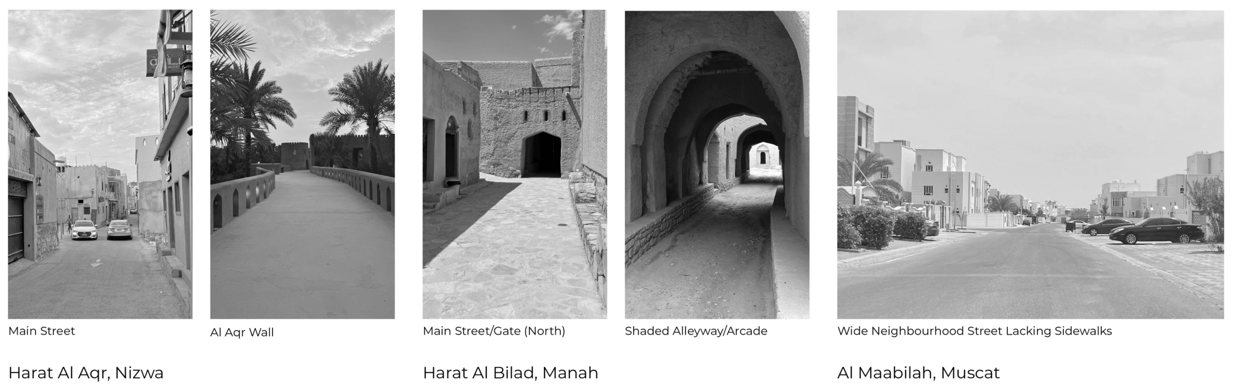
The street and entry photographs in
Figure 6 reinforce these distinctions. Narrow routes in Nizwa and Manah were bounded by high, continuous walls and produced long shade bands. In Al Maabilah, roads were wider and flanked by detached walls, driveways, parking, and discontinuous shade. The images also document gates, alleys, façades, entrances, and the exposed road environment.
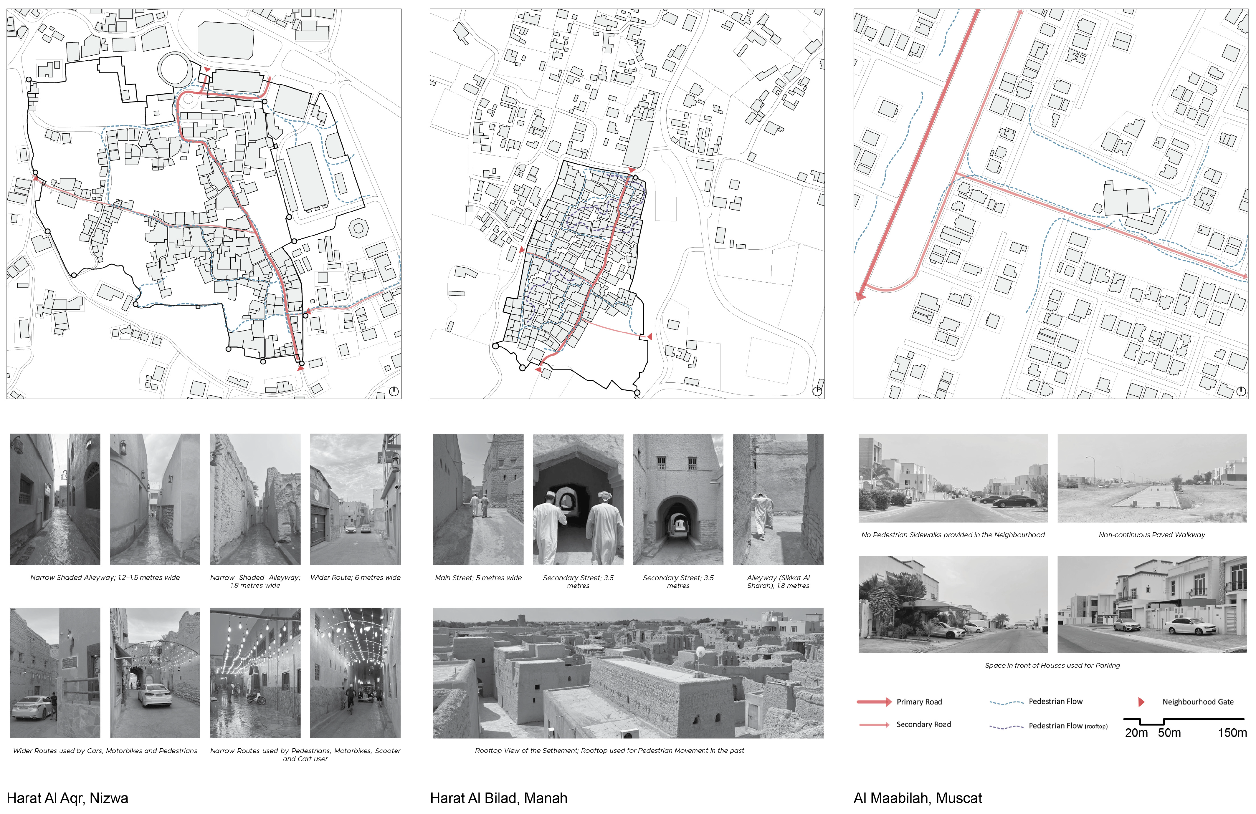
The accessibility analysis identified clear differences in route structure, dimensions, movement types, and pedestrian conditions across the three settlements. In Harat Al Aqr, the network consisted of narrow shaded alleys measuring approximately 1.2–1.8 m in width and wider internal routes reaching about 6 m. The narrow alleys primarily served pedestrians, while the wider routes accommodated carts, motorcycles, pedestrians, and limited vehicle access. These routes extended through the compact settlement fabric and connected dwellings with gates, public spaces, and surrounding streets, as shown in
Figure 7.
Harat Al Bilad displayed a more clearly defined route hierarchy. Its main public street measured approximately 5 m wide, secondary streets were about 3.5 m wide, and the private sikka narrowed to approximately 1.8 m. The main street provided access along the settlement edge, while secondary routes and private alleys extended into the residential fabric. The photographic evidence also records enclosed passages and shaded entrances. Rooftop connections formed an additional pedestrian route in the past and allowed movement between closely spaced buildings without relying only on ground-level streets.
In Al Maabilah, the accessibility structure was organized around a wide primary road and secondary vehicular streets. A typical one-lane road measured approximately 7 m wide, with additional setback space between the carriageway and residential boundaries. The mapped pedestrian routes were discontinuous and did not form a connected network. The photographs show streets without continuous sidewalks, isolated paved walkways, and front setbacks used mainly for parking. Unlike the historic settlements, pedestrian movement occurred alongside broad roads and separated building plots rather than through narrow internal routes.
Participants consistently associated the historic routes with shade and walkability. The Nizwa participant stated that “narrow alleyways provide enough and proper shade for people to walk comfortably.” The Manah interviewee recalled a “light breeze cooling down the place.” In contrast, the Al Maabilah participant stated that “it is difficult to walk in the heat” because there were no continuous shaded sidewalks.
“…Since the buildings were in close proximity to one another, it was easy and comfortable for people to walk between the high buildings in the shade with a light breeze cooling down the place. Some alleyways were quite long and dark, so people sometimes preferred to use the rooftops for quick visits.”
(Respondent from Harat Al Bilad, Manah)
“…It is difficult to walk in the heat to go to a shop or the mosque unless we live immediately next to it. There are no proper shaded sidewalks for people to walk or cycle. People mainly walk during the evening for exercise.”
(Respondent from Al Maabilah, Al Seeb)
Material characteristics reinforced the morphological differences. Nizwa and Manah used stone foundations, thick mudbrick walls, earthen or gypsum finishes, timber beams, palm-frond layers, and small wooden openings. Al Maabilah used reinforced-concrete frames, concrete-block infill, cement plaster, paint or cladding, aluminium frames, and larger glazed windows. Participants in both historic cases associated earthen walls with thermal moderation, while the Al Maabilah interviewee associated concrete with heat absorption and air-conditioning dependence.
The Manah participant stated that modern wall and pavement materials “do not allow the surface to breathe,” leading to cracking and regular maintenance. The Al Maabilah participant explained that concrete remained common because “everyone nowadays uses it” and contractors were familiar with it. Material selection was therefore influenced not only by environmental performance but also by available skills, contractor practices, durability expectations, and maintenance perceptions.
4.3. Building Performance Analysis
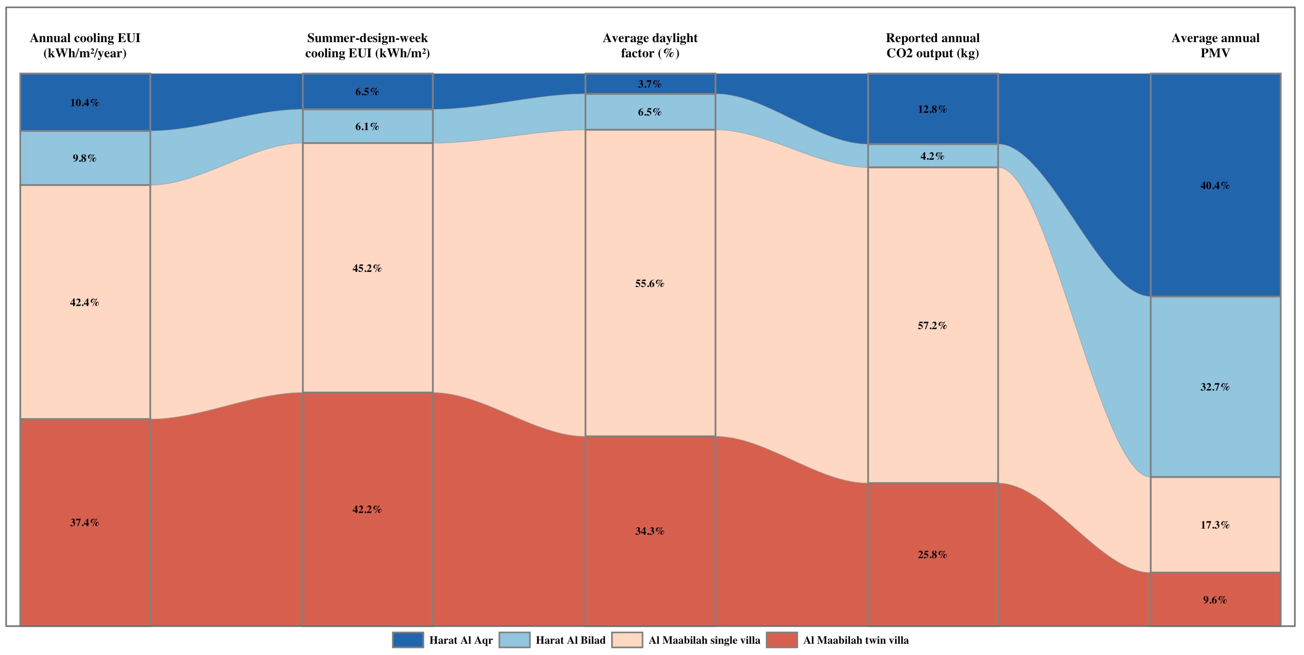
The building-performance simulations identified substantial differences among the four representative dwelling types. The comparison included annual cooling-energy demand, summer-design-week cooling demand, average daylight factor, predicted mean vote, and modelled carbon emissions. The complete results are presented in
Figure 8. Because the models represent different dwelling forms and conditioning strategies, the values are reported as comparative simulation outputs rather than measured performance in occupied buildings.
Annual cooling demand was lowest for the Harat Al Bilad dwelling at 60.70 kWh·m−2·yr−1. The Harat Al Aqr dwelling recorded a similar value of 64.47 kWh·m−2·yr−1. Cooling demand was considerably higher in Al Maabilah, reaching 263.35 kWh·m−2·yr−1 for the single villa and 232.20 kWh·m−2·yr−1 for the twin villa. Compared with the single villa, the simulated annual cooling demand was 75.5% lower in Harat Al Aqr and 77.0% lower in Harat Al Bilad. Compared with the twin villa, the corresponding differences were 72.2% and 73.9%.
The summer-design-week results followed the same pattern. Harat Al Aqr recorded 1.23 kWh·m−2, while Harat Al Bilad recorded 1.16 kWh·m−2. The single and twin villas recorded 8.54 and 7.97 kWh·m−2, respectively. The two historic dwelling models therefore remained close to one another across both annual and peak-summer cooling indicators, while both contemporary villa models recorded substantially higher values.
The participant narratives contextualized these results. The Nizwa participant stated that mud houses “function much better than houses made of concrete” under extreme heat, although they require continued maintenance. The Manah participant similarly argued that small openings provided light “without overheating” the interior.
“…Mud houses function much better than houses made of concrete because they can withstand heat and simultaneously cool the interior spaces. They may need maintenance, but they can last longer than cement houses if they are built correctly.”
(Respondent from Harat Al Aqr, Nizwa)
“…Concrete is known for absorbing and transmitting heat, which is why air conditioners are used to cool interior spaces. It is still frequently used because of its durability and because contractors are familiar with it.”
(Respondent from Al Maabilah, Al Seeb)
The daylight results showed a contrasting pattern. Harat Al Aqr recorded an average daylight factor of 0.4%, while Harat Al Bilad recorded 0.7%. The Al Maabilah single villa recorded 6.0%, and the twin villa recorded 3.7%. The contemporary villa models therefore produced brighter interiors, whereas the smaller and more controlled openings of the historic dwellings resulted in substantially lower daylight levels.
Predicted mean vote values were also closer to thermal neutrality in the contemporary villas. The twin villa recorded the lowest PMV of 0.5, followed by 0.9 for the single villa. Harat Al Bilad recorded 1.7, while Harat Al Aqr recorded 2.1. Under the adopted operational assumptions, the mechanically cooled villas achieved more neutral indoor conditions. The naturally ventilated historic dwelling models remained warmer.
Modelled carbon emissions followed the general pattern of energy demand. Harat Al Bilad recorded the lowest value at 12.0 kg CO
2, followed by Harat Al Aqr at 36.8 kg CO
2. The twin villa recorded 74.4 kg CO
2, while the single villa recorded the highest value at 164.8 kg CO
2. These values reflect the simulation inputs and electricity-conversion assumptions reported in
Appendix A and are only used for comparison among the four models.
The field and interview evidence also identified differences in material knowledge and community practices. In Harat Al Aqr, mud-brick preparation, sarooj plaster, local timber, shared walls, wells, the falaj, communal ovens, settlement gates, and adaptive reuse remained connected with continuing occupation and maintenance. Harat Al Bilad retained earthen construction, traditional finishes, timber roofs, wells, terraces, and communal infrastructure. However, limited occupation reduced opportunities for active use and knowledge transmission.
Al Maabilah reflected a different knowledge system based on reinforced-concrete construction, concrete-block infill, cement plaster, contractor-led building practices, vehicle access, parking, and mechanical cooling. Privacy was managed mainly through plot walls and window placement rather than through settlement gates, private alleys, or layered route hierarchies.
The cross-case differences in material knowledge, climate-related practices, shared-resource use, privacy, and knowledge continuity are summarized in
Table 3. The table shows that the historic cases retained stronger relationships between physical fabric and community-based knowledge, while Al Maabilah reflected standardized construction and individually managed services. These findings indicate that material practices and community knowledge were sustained most clearly where physical conservation remained connected with occupation, everyday use, and continuing maintenance.
4.4. From Observed Heritage Values to Operational Strategies
The cross-case analysis identified three recurring physical mechanisms. These were neighbourhood enclosure and shade continuity, envelope thermal capacity and exposed surface area, and the size and position of openings. Each mechanism was also connected with social and cultural practices such as privacy, movement, household organization, community interaction, and local maintenance knowledge.
Street enclosure was strongest in Harat Al Aqr and Harat Al Bilad. Narrow routes and attached buildings reduced direct façade exposure and created continuous shade at ground level. Al Maabilah contained wider roads and detached plots. These conditions exposed more building surfaces and interrupted pedestrian shade. The reported differences in walking behaviour reflected this contrast. The Al Maabilah participant stated that residents mainly walked during the evening because daytime routes lacked sufficient shade.
Opening configuration produced the clearest contrast between the historic and contemporary dwellings. Small and elevated openings in the historic cases reduced external exposure and limited direct views. However, the simulation results also showed lower daylight levels. Larger windows in Al Maabilah increased daylight availability but created more exposed glazing. The results therefore identified a measurable relationship among opening size, solar exposure, daylight, and privacy.
“…The main advantage was the community. People knew the balance between sharing and protecting privacy, and this was reflected in the simple and functional architecture. Public and private movement were separated without preventing people from interacting.”
(Respondent from Harat Al Bilad, Manah)
“…We lack greenery, proper walkways, and safe outdoor spaces for children. The mosque and small shops meet basic needs, but the neighbourhood does not provide the same quality of shaded, usable, and connected public space.”
(Respondent from Al Maabilah, Al Seeb)
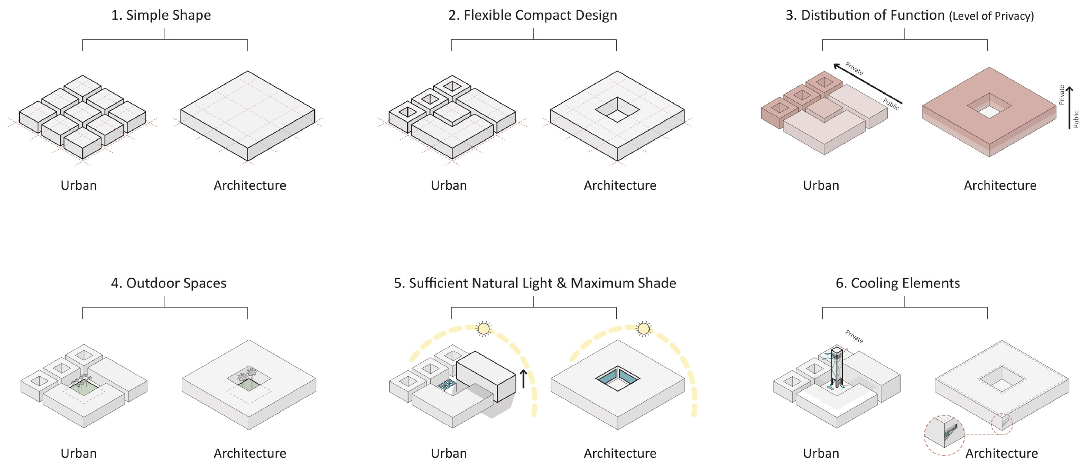
The six strategies developed from these findings are presented in
Figure 9. At the urban scale, simple modular forms supported efficient plot arrangement and building clustering. At the architectural scale, the modules were consolidated into compact courtyard buildings. Flexible configurations allowed for adaptation to different plot sizes and household requirements.
Functions were distributed according to privacy levels. Public and communal spaces were positioned near entrances and external edges. Private household areas were arranged around internal courtyards or on upper floors. Outdoor spaces were incorporated as protected areas for household activity, greenery, recreation, and social interaction.
The strategies also combined compact form with shaded pedestrian routes and controlled openings. Natural-light access was retained while excessive external exposure was reduced through inward orientation, recessed openings, and courtyard organization. Vegetation, shaded courts, water elements, wind towers, and ventilation openings were included as passive-cooling components.
4.5. Architectural Prototype Testing
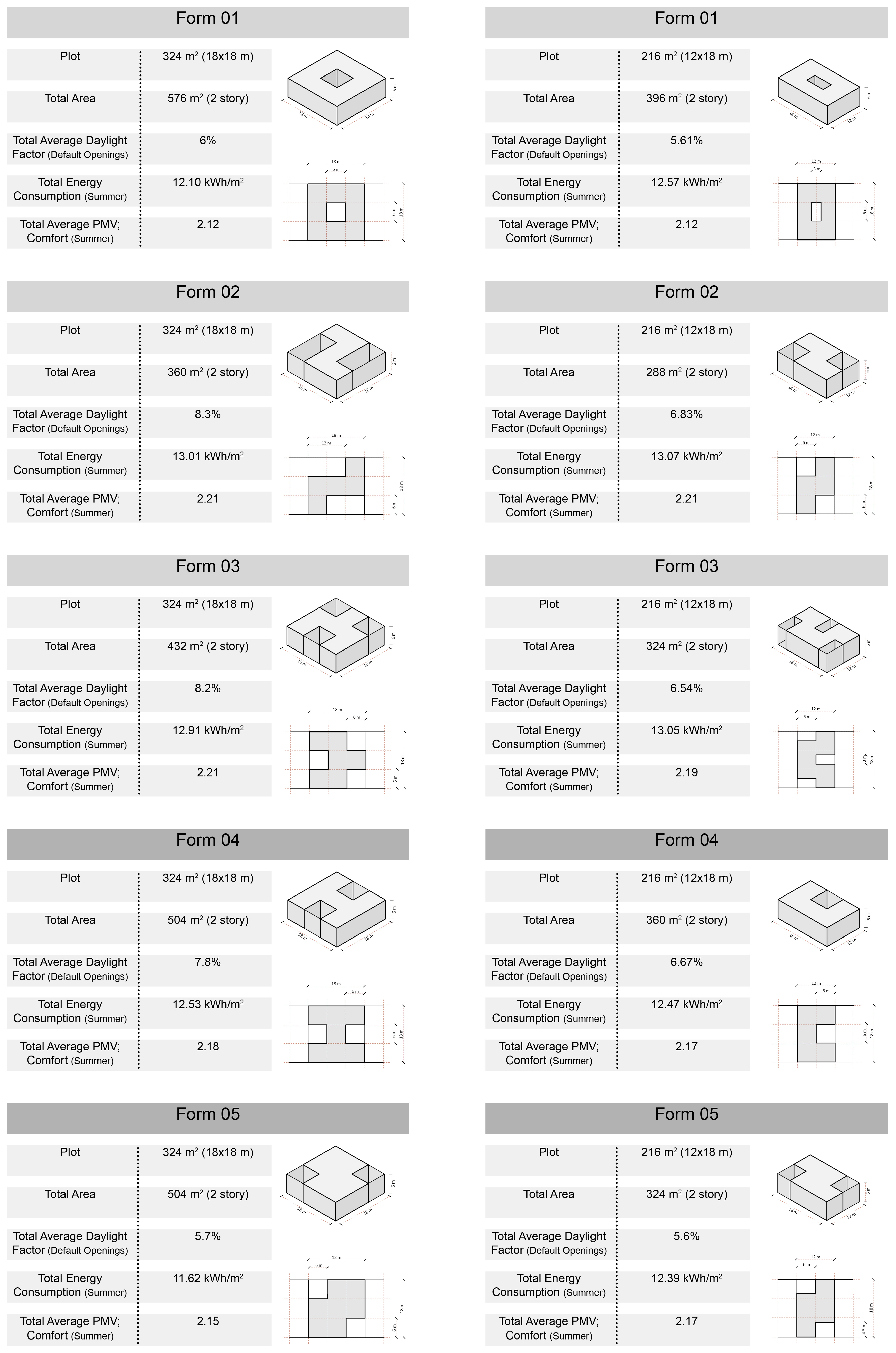
The architectural prototype stage tested courtyard-based forms for two plot sizes: 18 m × 18 m and 12 m × 18 m. Five forms were developed for each plot type and evaluated during the summer design week. The comparative criteria included built area, energy demand, PMV, and daylight factor. The form-testing results are presented in
Figure 10. Each form altered the location and proportion of the courtyard, the degree of enclosure, external-wall exposure, and the relationship between indoor and outdoor space.
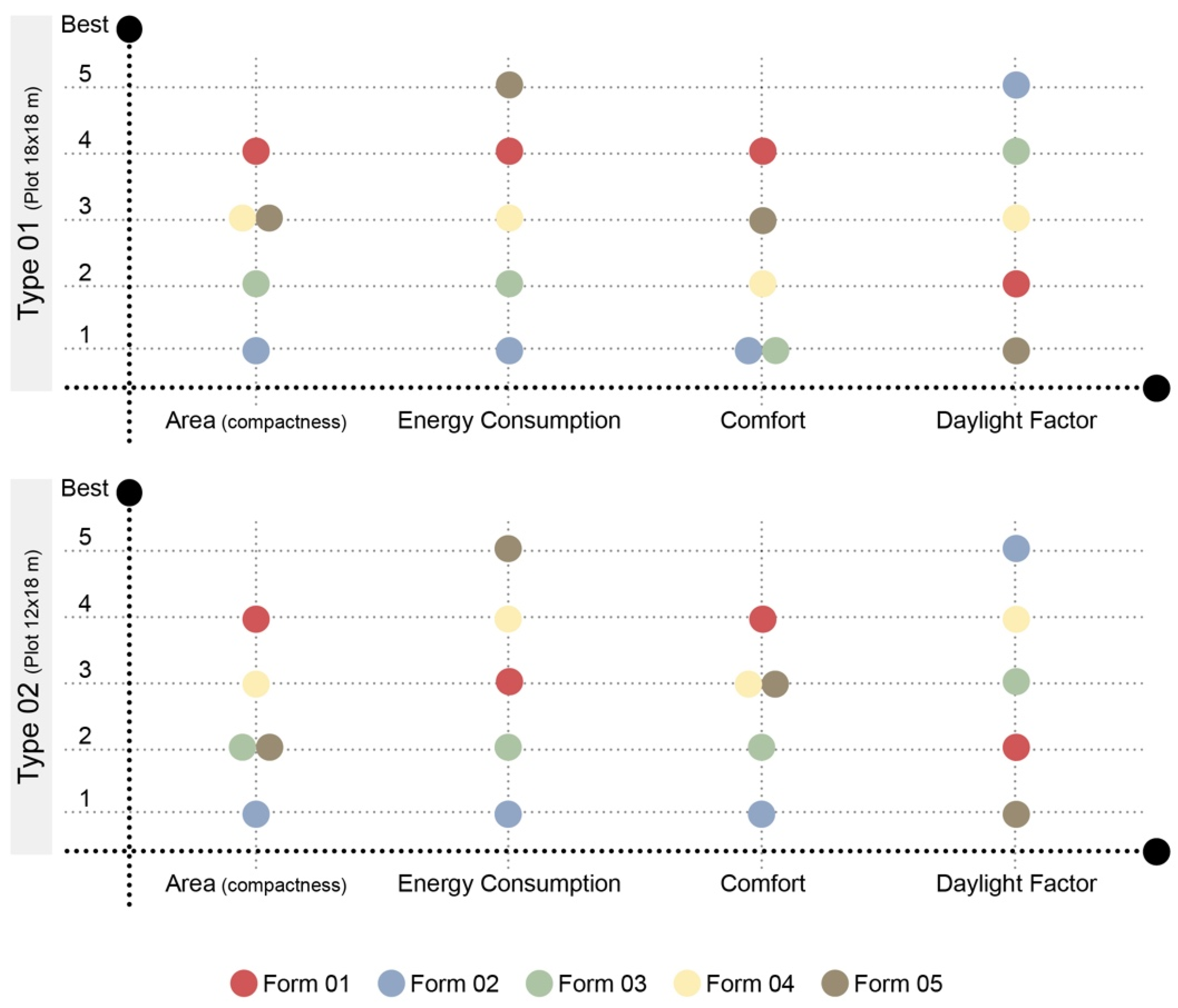
The results were then converted into a five-point comparative rating, shown in
Figure 11. Higher area scores represented a more compact use of the plot, lower energy values represented improved efficiency, PMV values closer to zero represented more neutral conditioned comfort, and higher daylight-factor values represented brighter interiors.
Forms 02 and 03 achieved relatively strong daylight values but performed less consistently across the remaining criteria. Their higher daylight performance was therefore not sufficient to justify selection. Form 04 produced a more balanced profile, with no single criterion performing exceptionally poorly. Form 05 recorded the strongest energy performance and retained adequate space for the courtyard. Form 01 provided a high built-up area but left comparatively little unbuilt private space, weakening the intended courtyard function.
The selection of Forms 04 and 05 reflects an attempt to balance compactness, energy demand, privacy, daylight, and outdoor space. This differs from selecting the lowest-energy option alone. A highly compact form could minimize exposure but fail to provide usable outdoor space. A highly open form could improve daylight but increase heat gain. The selected forms therefore represented negotiated rather than absolute optima. The interview findings provided cultural criteria for the layouts. Contemporary households expected ground-floor majlis spaces, kitchens, guest rooms, storage, bathrooms, and direct access.
“…The ground floor is more used as a communal space and for services, including the living room, majlis, kitchen, and storage. The upper floor contains bedrooms, and the outdoor space is used either for parking or as a garden and sitting area.”
(Respondent from Al Maabilah, Al Seeb)
“…The rooms were placed on the upper level for privacy, together with the kitchen and communal terrace. The terrace served as the main living space and ventilation point around which other rooms were organized.”
(Respondent from Harat Al Bilad, Manah)
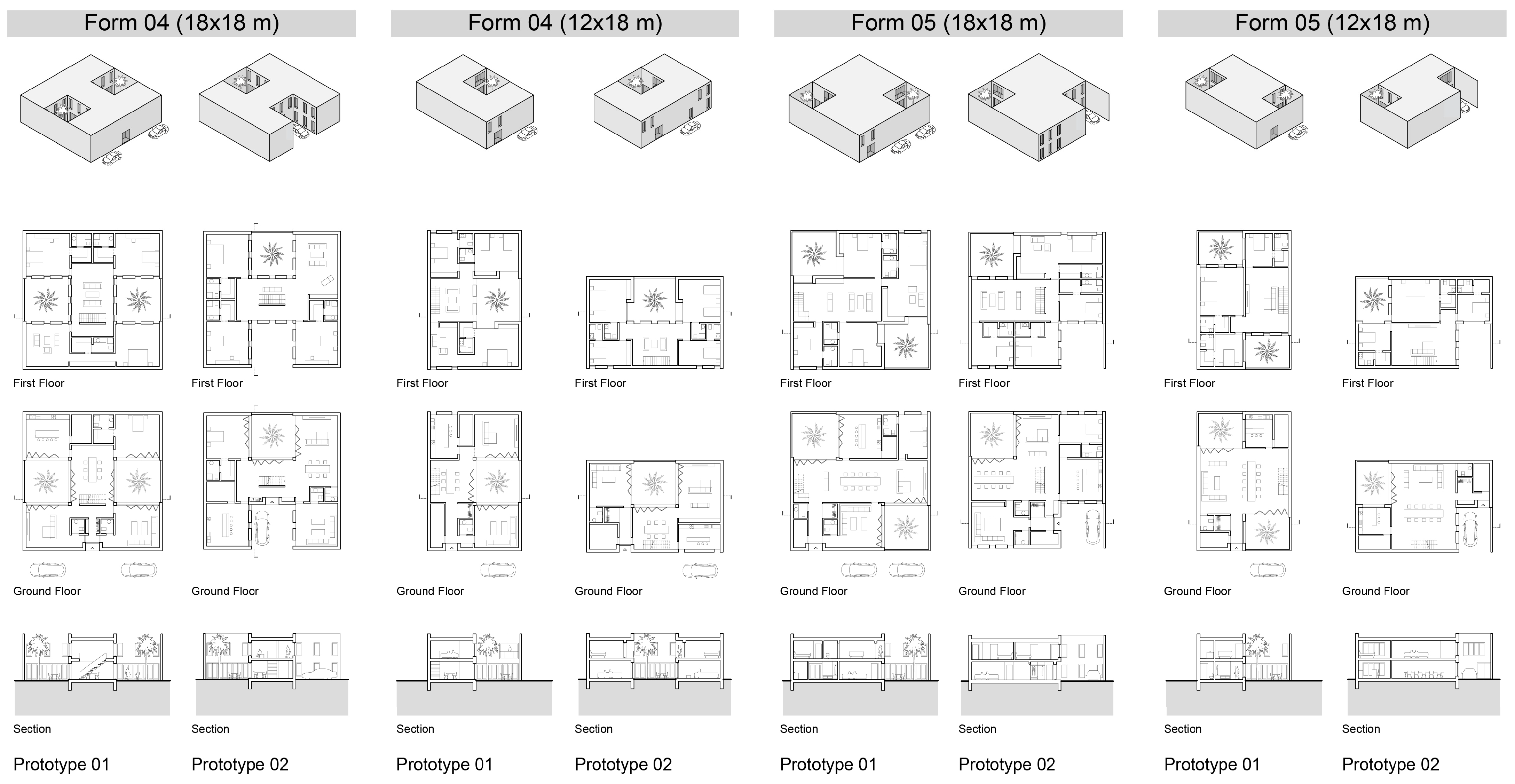
The eight resulting prototypes are presented in
Figure 12. These combined the selected forms with two plot sizes and alternative internal arrangements. Each prototype included a private outdoor court, ground-floor communal and service functions, and upper-floor family spaces. Flexible rooms could operate as offices, guest rooms, or expanded living areas. Variations in courtyard placement, circulation patterns, and room configuration allowed the prototypes to respond to different household structures and privacy requirements. Collectively, the schemes demonstrate how compactness, spatial flexibility, controlled daylight, and protected outdoor living can be integrated within contemporary residential design.
The prototypes also responded to interview concerns about contemporary privacy. Boundary walls alone could not prevent upper-level overlooking in detached-villa districts. Inward-facing courts reduced this problem by controlling views between neighbouring units. At the same time, they retained contemporary expectations for larger rooms, multiple bathrooms, vehicle access, and flexible household use.
“…Boundary walls provide privacy from the street, but neighbouring upper floors may still overlook the outdoor space. The location of windows and the organization of the house therefore remain important.”
(Respondent from Al Maabilah, Al Seeb)
4.6. Cluster Assembly, Density, and Shared Outdoor Space
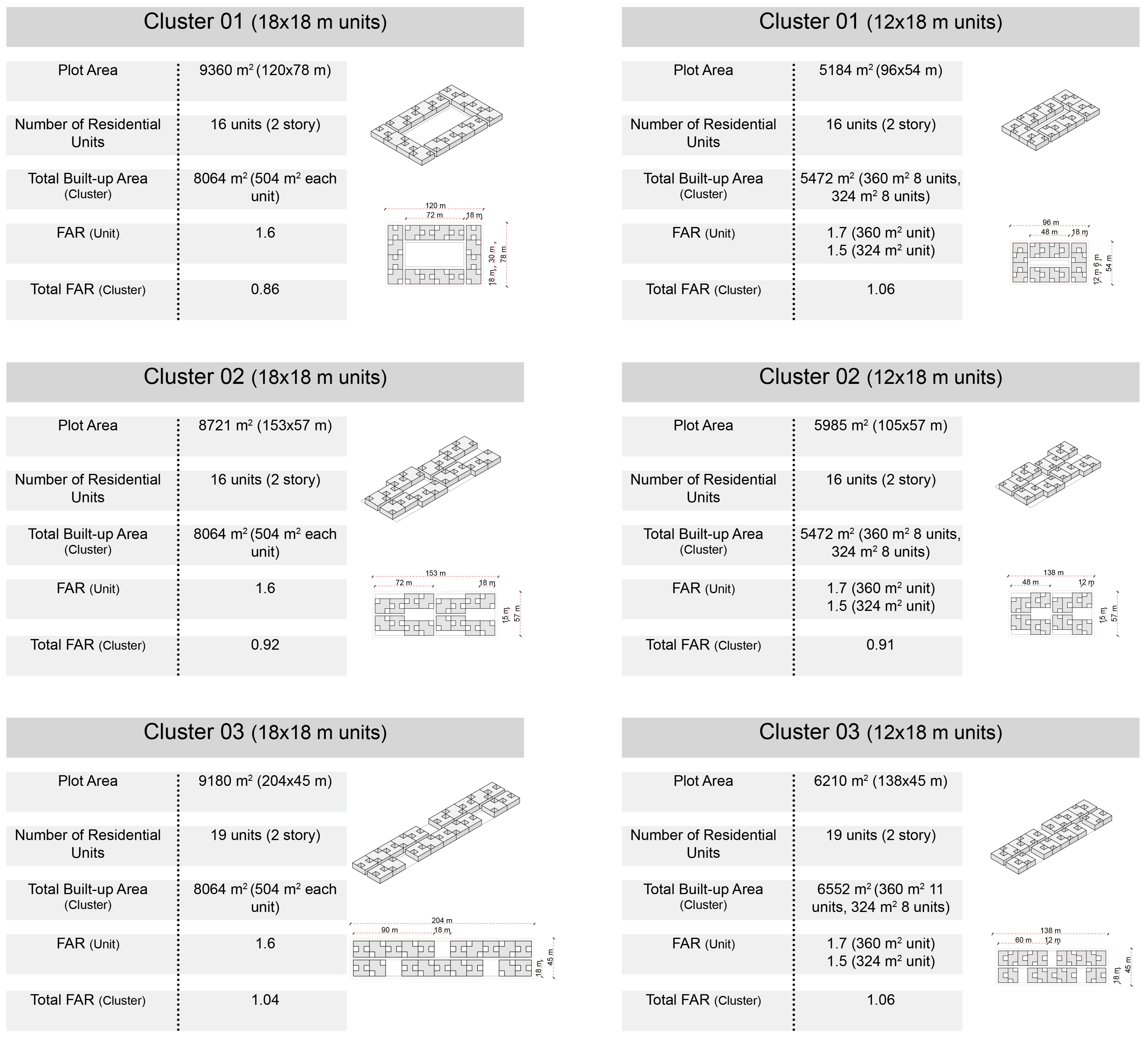
The urban-scale stage assembled the residential prototypes into three cluster arrangements for each plot type. Cluster 01 organized units around a central communal space. Cluster 02 created hidden pocket parks and widened alleys. Cluster 03 distributed smaller pocket parks among groups of dwellings. FAR results and physical arrangements are presented in
Figure 13. The objective was not to identify a universally superior cluster but to test whether greater density could coexist with different types of shared outdoor space.
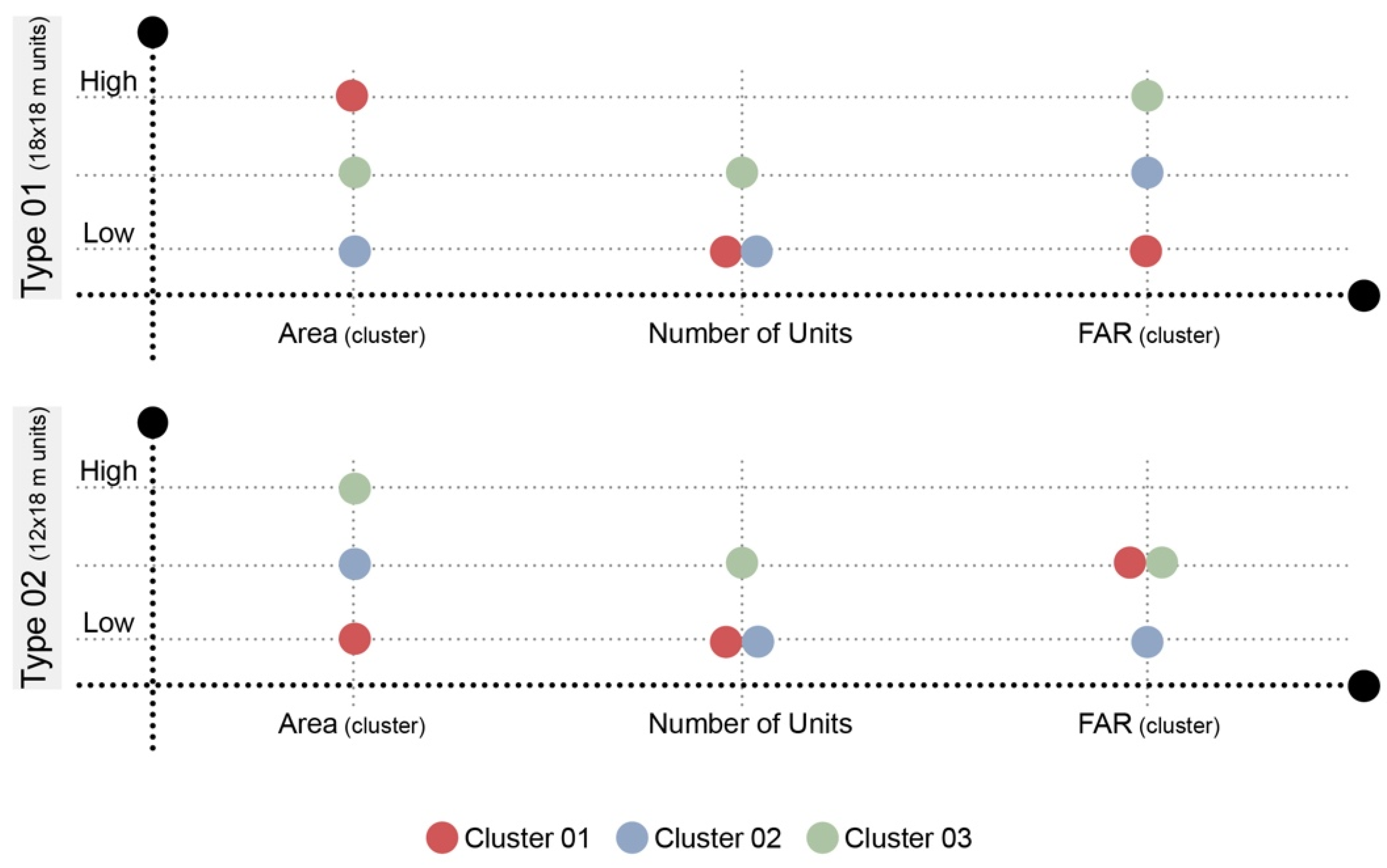
For the 18 × 18 m units, Clusters 02 and 03 achieved broadly similar built intensities. Cluster 01 contained the largest central open space and consequently recorded a slightly lower FAR. For the 12 × 18 m units, Clusters 01 and 03 recorded similar FAR values, although Cluster 03 contained a larger site and more units. Cluster 02 achieved a closely comparable FAR.
The comparison graphs in
Figure 14 show that all arrangements could generate higher densities while producing different outdoor-space conditions. The central-court cluster concentrated activity in one visible location. The hidden-pocket-park arrangement created semi-private spaces connected by widened routes. The distributed-pocket-park arrangement provided several localized gathering spaces.
The interview narratives provide evidence for why a range of communal-space types was retained. Historic outdoor spaces supported trade, sitting, celebrations, domestic production, prayer-related gathering, children’s activity, and informal neighbour contact. In Al Maabilah, participants identified a shortage of well-designed public space and safe outdoor areas.
“…Alleyways were used to sit in the shade and engage in conversation or poetry recitation. The main road was used by salespeople, residents, and events, while the shared tanoor supported celebrations.”
(Respondent from Harat Al Bilad, Manah)
“Some neighbourhood centres have a park or shops next to the mosque, but the spaces are not well designed or can only be used during certain periods. Other centres have shops but no public park, so residents must go farther away.”
(Respondent from Al Maabilah, Al Seeb)
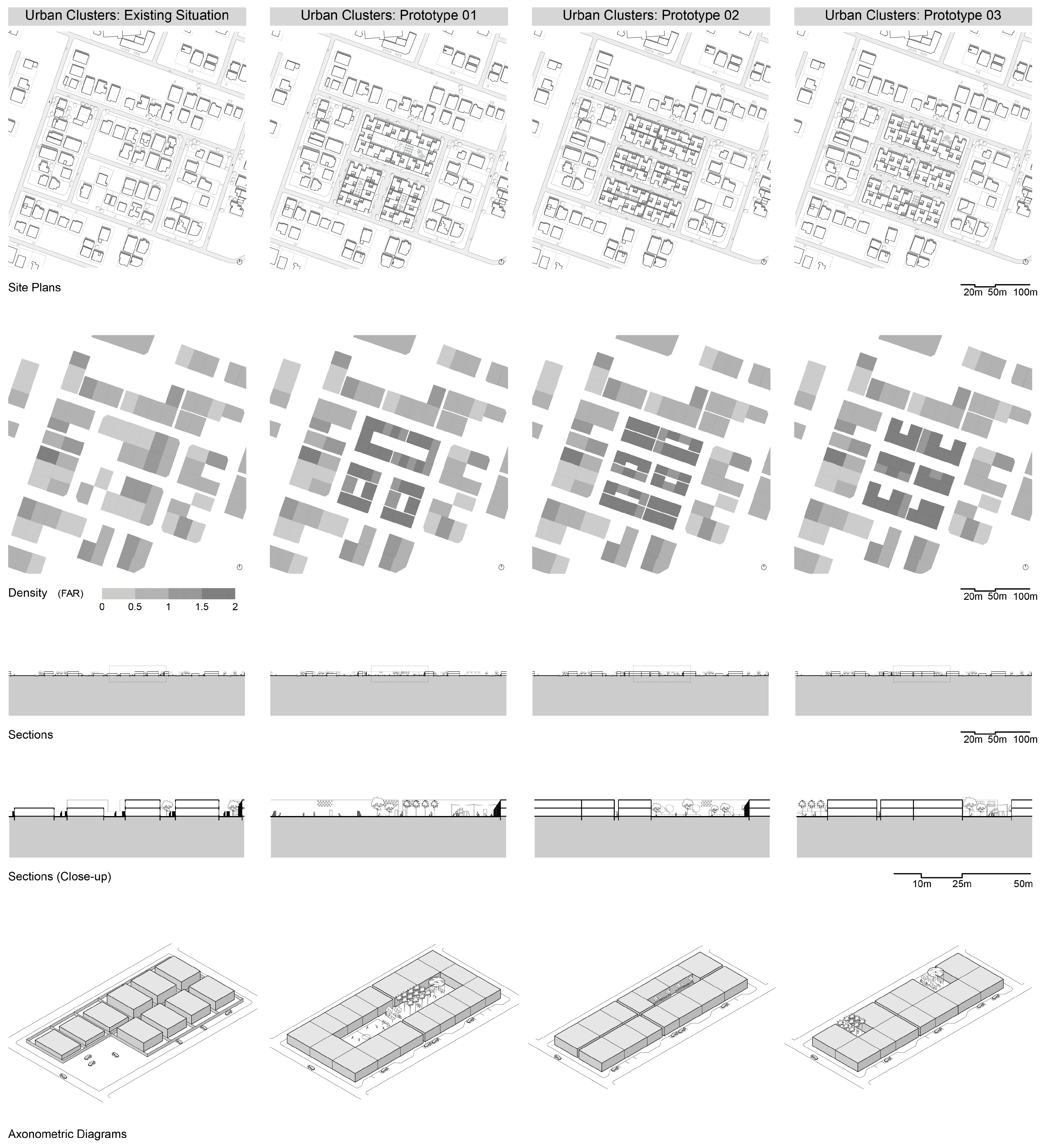
The existing cluster recorded an average FAR of approximately 0.7. It was characterized by detached buildings, wide separation between units, discontinuous building edges, and open areas used mainly as setbacks, roads, and parking. The three proposed configurations increased the average FAR to approximately 1.6. The FAR maps show that higher intensity was concentrated within the redesigned central area while the surrounding neighbourhood remained unchanged. This increase was achieved through closer building spacing, shared walls, greater plot occupation, and more continuous residential edges rather than substantial increases in building height.
Prototype 01 organized the housing units around a large central communal court. The site plan and axonometric diagram show a clearly enclosed shared space surrounded by continuous residential development. Prototype 02 arranged the units in parallel linear blocks. This produced narrow elongated open spaces between building rows and created the most regular internal circulation pattern. Prototype 03 used a more segmented arrangement. It distributed several smaller shared spaces between groups of dwellings and placed communal areas closer to individual housing clusters.
The sections confirm that all three prototypes retained a predominantly low-rise form. The higher FAR resulted mainly from two-storey construction and reduced separation between units. The close-up sections show that Prototype 01 created the widest central court. Prototype 02 produced more enclosed linear spaces, while Prototype 03 divided the open area into smaller pockets. The axonometric diagrams further demonstrate that each proposal achieved a similar increase in built intensity but produced a different relationship among housing units and communal outdoor spaces, as shown in
Figure 15.
The interview accounts also indicated that shared spaces should remain adaptable. The Nizwa participant described local spaces as changing in response to community needs. The Manah participant characterized streets and alleys as multifunctional spaces rather than routes with a single purpose. The Al Maabilah participant emphasized the need for safety, greenery, walkability, and proximity to dwellings.
“…We need greenery, proper walkways, and safe outdoor spaces for children. The basic services are present, but the neighbourhood needs spaces that people can use comfortably and safely.”
(Respondent from Al Maabilah, Al Seeb)
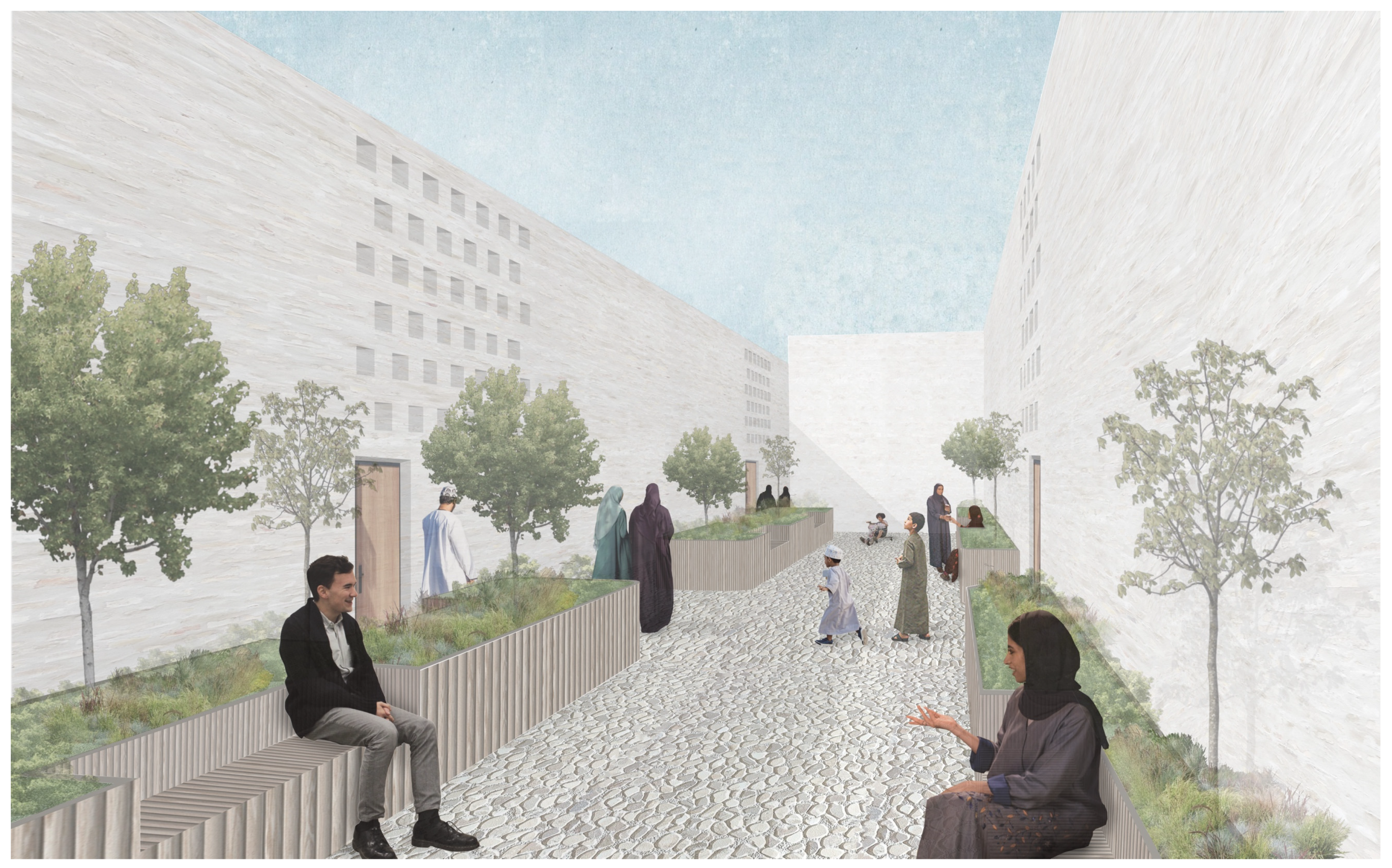
The final visualization translates these findings into a shaded pocket-park setting. It shows an enclosed pedestrian space located between residential buildings. Seating, planting, shaded edges, and direct access from nearby dwellings provide areas for sitting, walking, informal conversation, and children’s activity. The image represents the intended spatial and social character of the proposed communal space rather than a constructed or monitored outcome, as shown in
Figure 16.
5. Discussion and Policy Implications
The findings support values-based conservation approaches that treat heritage significance as socially attributed rather than as a fixed quality of historic fabric [
4,
5]. Across the three cases, heritage values emerged through relationships among physical attributes, environmental performance, continuing use, community experience, inherited knowledge, and institutional action. This is consistent with Riegl’s recognition that several values may coexist and conflict [
6]. Narrow alleys carried architectural-spatial value through enclosure and settlement character. They also carried environmental value through shade and social-cultural value through privacy and interaction. Earthen construction similarly combined material-technical, environmental, historical, and social significance. These findings support the Burra Charter’s recognition of plural cultural significance [
7] and Fredheim and Khalaf’s criticism of rigid value classifications [
8]. The six domains should therefore be understood as overlapping and context-specific analytical lenses rather than fixed categories.
Value attribution and prioritization also differed among actors. Residents and users emphasized privacy, accessibility, shared resources, climatic experience, community activity, and everyday usefulness. Heritage professionals and institutions placed greater emphasis on material integrity, compatible repair, and formal management. Business operators focused on viable use, visitor activity, employment, and maintenance funding. Technical analysis provided evidence concerning morphology and performance but could not independently determine cultural significance. These perspectives sometimes converged around continued occupation and compatible reuse. They also revealed conflicts. Tourism may generate functional-economic value while weakening privacy, residential continuity, material authenticity, or community control. These findings reinforce the importance of stakeholder engagement when cultural significance and intervention priorities are assessed [
7,
29].
The contrast between Harat Al Aqr and Harat Al Bilad demonstrates that preserving material fabric does not automatically sustain living heritage. Harat Al Aqr retained greater activity because conservation was connected with local enterprise, adaptive reuse, visitor management, employment, and partial residential continuity. Harat Al Bilad retained important buildings and settlement features but remained constrained by limited occupation, restricted activity, and weaker economic activation. This supports the living-heritage position that continuity of use, knowledge, care, and community association forms part of the heritage resource [
34,
35]. It also aligns with the Historic Urban Landscape approach, which places conservation within the broader social and economic processes shaping urban areas [
67,
68].
The findings consequently support settlement-scale management rather than conservation focused only on individual buildings or façades. Protecting isolated structures while losing route hierarchies, shared infrastructure, traditional materials, communal spaces, and maintenance practices would conserve only part of the heritage system. Settlement-scale conservation must consider relationships among buildings, streets, water systems, agricultural edges, public spaces, local enterprise, and community practices. This broader position is consistent with people-centred conservation and Historic Urban Landscape principles [
35,
67,
68].
The building-performance comparison adds an environmental dimension to this interpretation. The representative historic dwellings recorded substantially lower annual and summer cooling-energy demands than the contemporary villas under the adopted modelling assumptions. This pattern appears to reflect the combined influence of compact form, building attachment, reduced exposed-envelope area, thick earthen walls, controlled openings, and surrounding shade. The results are consistent with research on the environmental characteristics of earthen construction [
45] and the influence of courtyard enclosure and shade on thermal conditions [
38].
Lower simulated cooling demand did not mean that the vernacular dwellings achieved superior performance across every indicator. The mechanically cooled villas produced predicted mean vote values closer to thermal neutrality and substantially higher daylight factors. The historic dwellings remained warmer and darker under the adopted assumptions. Small openings reduced direct exposure and supported privacy, but they also restricted daylight. The results therefore reveal trade-offs among cooling demand, passive moderation, conditioned comfort, daylight, and privacy. Energy intervention in historic buildings must also account for moisture behaviour, material compatibility, reversibility, and user expectations [
44].
The architectural and cluster prototypes show how vernacular principles may inform contemporary development without requiring literal reproduction. Transferable elements are operational relationships rather than decorative references. Shared walls reduce exposed surface area. Street enclosure increases shade. Controlled openings influence heat gain, daylight, and privacy. Internal courts create protected outdoor space. Mixed-use proximity shortens the distance between daily activities. The prototypes converted these relationships into adjustable design variables, including courtyard proportion, opening position, shared-wall length, route width, and communal-space distribution. Their use of courtyards and internal spatial organization is consistent with evidence that courtyard form can support climatic and social functions when its geometry and use are carefully considered [
42,
56].
Privacy remains central when compact morphology is translated into contemporary housing. Altman’s interpretation of privacy as the regulation of access, visibility, and interaction explains why public–private gradients cannot be simply replaced by high plot walls [
54]. The Al Maabilah interview showed that neighbouring upper floors could overlook private outdoor areas despite the presence of boundary walls. Inward-facing courts, controlled windows, transitional entrances, route hierarchy, and vertically organized family spaces may provide a more layered response. Public acceptance of compact development also depends on privacy, safety, cultural compatibility, social interaction, and design quality rather than numerical density alone [
71]. The proposed FAR increase from approximately 0.7 to 1.6 therefore demonstrates spatial capacity rather than immediate implementation feasibility.
To synthesize the findings,
Table 4 distinguishes among heritage attributes that should be conserved, vernacular principles that may be adapted, and interventions that require negotiation. Conservation priorities include historic settlement structure, attached buildings, narrow shaded routes, public–private hierarchies, earthen fabric, shared-resource systems, communal facilities, and traditional construction knowledge. Adaptation priorities include compactness, shared-wall principles, connected shade, courtyard and terrace organization, controlled openings, thermal mass, mixed-use proximity, and locally appropriate materials. Negotiation is required where intervention involves tourism, privacy, accessibility, emergency access, parking, infrastructure, building regulation, commercial reuse, ownership, or governance.
Conservation, adaptation, and negotiation should not be treated as isolated stages. A single feature may require more than one response. Shared walls should be conserved where they contribute to historic morphology. The same principle may be adapted in new housing to reduce external exposure. Its implementation may still require negotiation where ownership, fire regulation, acoustic performance, or maintenance creates constraints. Traditional water systems similarly require the conservation of physical infrastructure and the continuation of management knowledge. They may also require negotiation where contemporary health, safety, and service requirements apply.
The findings further confirm that restoration and regeneration are related but distinct. Physical conservation can stabilize structures and retain architectural evidence. Regeneration requires occupation, coordinated management, economic activity, public-space use, infrastructure, and community participation. Previous research identifies regulation, cost, technical uncertainty, ownership, and commercial viability as major adaptive-reuse challenges [
63]. Practice-based models also describe reuse as a sequence involving value identification, documentation, design, implementation, use, and evaluation [
69]. Comparable experience from Jordan shows that heritage reuse in the Middle East can be constrained by building regulations, infrastructure limitations, financial barriers, technical knowledge, and weak stakeholder coordination [
78]. Governance should therefore involve residents, property owners, craftspeople, businesses, municipal authorities, heritage agencies, and tourism managers.
Policy intervention should operate at both building and neighbourhood scales. Building-level action should prioritize compatible repair materials, moisture behaviour, roof integrity, controlled openings, passive ventilation, and reversible service upgrades. Neighbourhood-scale policy should protect street enclosure, connected shade, movement hierarchies, mixed functions, shared infrastructure, and relationships with agricultural and water systems. Aflaj illustrate why environmental infrastructure must be interpreted socially as well as technically. Their significance depends on management rules, labour, agricultural use, resource sharing, and local knowledge [
58].
Heritage-led regeneration may require public investment, residential rehabilitation, craft training, maintenance incentives, infrastructure improvement, and support for locally owned businesses. Economic activation should nevertheless be monitored to prevent excessive commercialization, displacement, or the loss of residential and cultural functions. Tourism management should protect local privacy and daily access while supporting maintenance revenue and employment. Infrastructure upgrading should improve safety and usability without unnecessarily removing narrow routes, historic materials, or spatial hierarchies.
The principal theoretical contribution lies in framing vernacular settlements as living climate-responsive heritage systems. Their significance arises through interactions among material, spatial, environmental, social, cultural, functional, and economic values. Methodologically, the combination of morphological analysis, field documentation, interviews, and simulation allows different evidence streams to support or challenge one another. Practically, the framework distinguishes what should be conserved, what may be adapted, and what requires negotiation. It therefore avoids both the romanticization of vernacular settlements and the uncritical acceptance of contemporary development patterns.
6. Conclusions
This study examined how vernacular heritage can inform climate-responsive conservation, adaptive reuse, and urban regeneration in contemporary Oman. By combining urban morphological analysis, field documentation, community narratives, and comparative building-performance simulation, the research showed that vernacular settlements should not be understood as collections of isolated historic buildings. Their heritage significance is relational and arises through interactions among physical attributes, environmental performance, social practices, inherited knowledge, continuing use, and the actors who attribute meaning to these places.
The study applied six interconnected value domains: historical-continuity, architectural-spatial, environmental, material-technical, social-cultural, and functional-economic value. The findings demonstrate that these domains overlap rather than operate as fixed or independent categories. Narrow alleys, for example, carried architectural-spatial value through enclosure and settlement character, environmental value through connected shade, and social-cultural value through privacy, movement, and interaction. Earthen construction similarly combined material-technical value with environmental performance, craftsmanship, maintenance knowledge, and cultural continuity. The relevance of the value framework therefore lies in revealing how individual attributes can support several forms of significance and how interventions may strengthen one value while weakening another.
The comparative analysis found that the historic settlements achieved relatively high built intensities through attached buildings, shared walls, limited setbacks, and narrow circulation networks rather than through vertical development. Their compact morphology supported connected shade, reduced external-envelope exposure, shortened distances between elements of daily functions, and layered public–private organization. Interview narratives connected these attributes with resource sharing, household privacy, gendered use of space, collective security, social interaction, and local maintenance knowledge. The simulations also indicated substantially lower cooling-energy demand in the representative vernacular dwellings, although the contemporary villas achieved conditions closer to thermal neutrality under mechanical cooling and provided higher daylight levels. Vernacular performance should therefore not be romanticized as universally superior or reproduced literally.
The contrasting cases further showed that physical restoration alone does not constitute regeneration. Community-led adaptive reuse supported occupation, employment, local enterprise, visitor activity, and continuing maintenance, whereas conservation without sustained use produced a more physically protected but socially inactive environment. Effective regeneration therefore requires compatible repair, community participation, viable functions, local economic benefits, sensitive tourism management, and coordination among residents, craftspeople, institutions, authorities, and private operators.
The six value domains should be understood as a context-specific analytical structure rather than a universal or exhaustive typology. Their interpretation is bounded by the selected cases, available stakeholder perspectives, qualitative interview evidence, and comparative simulation assumptions. Hence, the study clarifies what should be conserved, which vernacular principles may be adapted, and which interventions require negotiation. Its principal contribution is to connect attributed heritage values with spatial evidence, environmental performance, community knowledge, and regeneration feasibility while making value overlaps and trade-offs explicit. Vernacular heritage should neither be frozen as a museum environment nor reduced to decorative references. Its long-term relevance depends on conserving the authentic fabric, sustaining living knowledge, supporting compatible use, and translating climate-responsive principles into contemporary forms that meet social, environmental, and functional needs.
7. Limitations and Future Directions
This study has several limitations that shape the interpretation and transferability of its findings. First, the analysis was based on three purposively selected cases: Harat Al Aqr as an actively regenerated historic settlement, Harat Al Bilad as an institutionally conserved but largely inactive settlement, and Al Maabilah as a contemporary villa-based neighbourhood. This structure enabled comparison of morphology, materials, environmental performance, community knowledge, and regeneration, but it does not represent the full diversity of Omani settlements. Climatic differences between inland Nizwa and Manah and coastal Al Maabilah also restrict direct environmental comparison.
Second, the interview evidence was qualitative and derived from three consolidated case-specific records. Although the interviews clarified privacy practices, shared resources, material knowledge, movement, conservation, tourism, and neighbourhood change, the available records did not establish the total number or demographic profile of contributors. The findings therefore reflect the perspectives captured in the field documentation rather than the wider population. Some responses also relied on memories of earlier settlement life, and consolidation of notes may have reduced linguistic and cultural detail.
Third, the simulations compared four representative dwelling typologies reconstructed from plans, measurements, photographs, and documented materials. Long-term monitored data on indoor temperature, humidity, occupancy, window operation, HVAC use, and energy consumption were unavailable for full calibration. Assumptions concerning material properties, infiltration, schedules, internal gains, and mechanical conditioning mean that the results should be interpreted as comparative tendencies rather than exact predictions of occupied performance.
The study also did not measure outdoor microclimate conditions or calculate PET, UTCI, or mean radiant temperature. Statements regarding shaded walking, breezes, and outdoor comfort therefore represent participant experience and field observation rather than instrumented thermal assessment. Similarly, the proposed architectural and cluster prototypes were evaluated through modelling but were not constructed or tested for regulatory compliance, fire safety, emergency access, accessibility, infrastructure capacity, lifecycle cost, maintenance, or market acceptance.
Future research should extend the framework to additional coastal, mountain, desert, urban, and rural settlements. It should combine calibrated building simulations with long-term indoor and outdoor monitoring, material and hygrothermal testing, detailed daylight analysis, lifecycle carbon assessment, and post-occupancy evaluation. A larger and more diverse participant sample should include women, younger residents, craftspeople, property owners, planners, conservation professionals, developers, and tourism operators. Participatory workshops and pilot projects could help test how different stakeholders prioritize conservation, adaptation, and negotiation and whether the proposed design principles remain socially, technically, and economically viable under actual Omani conditions.