1. Introduction
Culture has been embedded in SDG 11 since UNESCO’s 2015 agenda, not as a fourth pillar but as a core element that fuses economic, social, and environmental objectives into human-centered development [
1,
2]. People interpret and reshape space through lived experience. Thus, policies that claim to be “inclusive” should account for how cultural meaning is understood and reproduced [
3].
Urban heritage is the clearest example of this recursive loop: it is simultaneously a physical artifact and a cultural carrier whose meaning is continuously renegotiated during revitalization [
4,
5]. Urban heritage refers to the built environment and its associated intangible cultural expressions, formed and bequeathed through historical development, which embody the collective memory, esthetic values, social functions, and cultural identity of a specific community [
6]. It encompasses individual monuments or buildings and emphasizes the holistic integrity of the urban fabric or landscape, comprising building clusters, street patterns, open spaces, infrastructure, and natural topography. Culture endows heritage with meaning and value, while heritage endows culture with a physical carrier and a space for representation. An object or place becomes the heritage of a community only when it is imbued with cultural value and significance by that group. Based on the characteristics of and relationship between culture and heritage revitalization, revitalized patterns can be divided into three types: interpretive revitalization, integrative revitalization, and instrumental revitalization [
7].
However, different groups understand the cues implied in heritage in different ways. Dan Kahan argued that individuals do not merely absorb information; they actively filter it through the lens of their pre-existing cultural worldviews to protect their identity and group affiliations [
8,
9]. This means the same material cue could be interpreted in radically different or even oppositional ways by different groups. For heritage revitalization, the necessary feedback must not only determine if significance is understood but, more critically, it must diagnose how it is cognized and refracted through these powerful cultural filters to truly judge whether revitalization efforts foster shared inheritance or inadvertently deepen cultural divides.
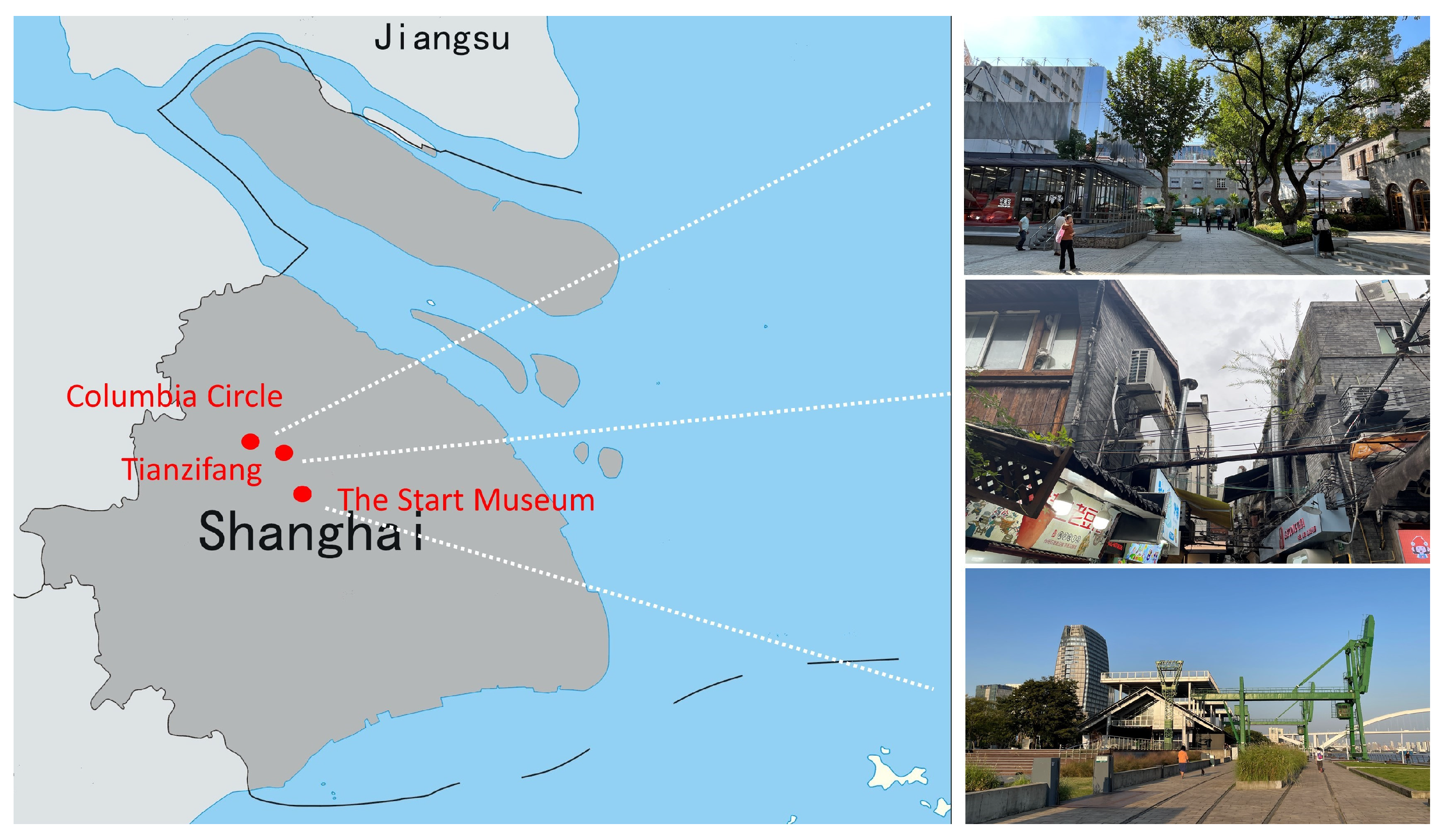
Shanghai has been a multicultural location since it opened to Western countries in 1843. Designers around the world have participated in its functional development, and Shanghai is the blended result. Studying Shanghai’s diversity can improve our understanding of culture. Tianzifang, Columbia Circle, and the Start Museum are typical heritage sites in Shanghai; they represent different phases of its rich local culture, but they have different results owing to their design strategies. Thus, they are suitable for exploring the effects of spatial configuration on cultural cognition.
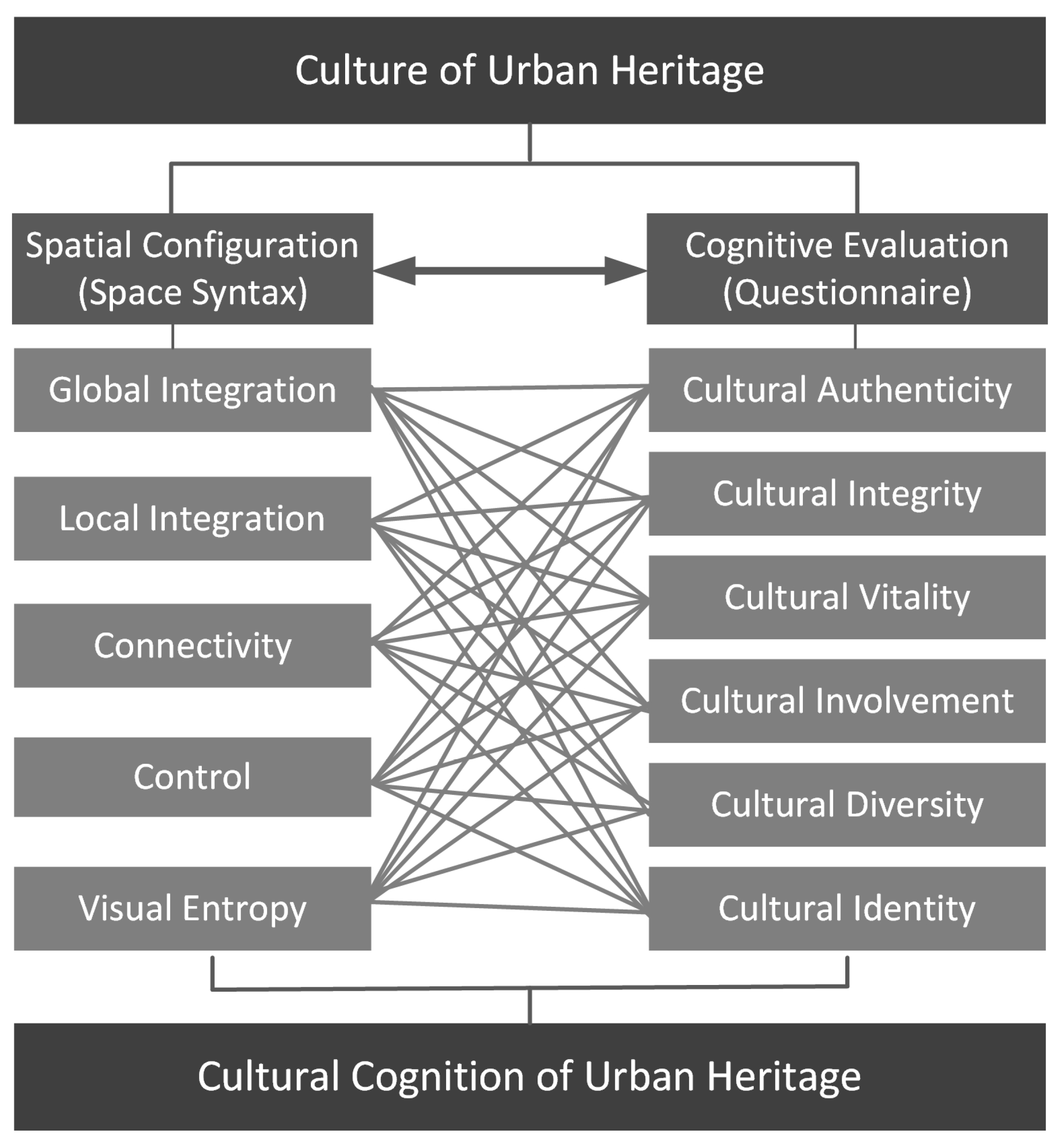
This study aims to understand the interaction between spatial configurations and cultural cognition after urban heritage revitalization. Following this introduction, the study is divided into three parts regarding the spatial configuration and cultural cognition of urban heritage: (1) The first part describes the factors and dimensions included in these components. (2) The second part describes the characteristics of each case. (3) The third part describes the relationship between the components in each case.
3. Methodology
This study aims to determine the influence of spatial configuration on cultural cognition after heritage revitalization by (1) utilizing space syntax to analyze the spatial configuration of the selected case; (2) exploring the cultural cognition of people in the selected case through questionnaires; and (3) analyzing the relationship between spatial configuration and the cultural cognition of heritage site revitalization with Spearman correlation analyses.
3.1. Study Area
Tianzifang, Columbia Circle, and the Start Museum are typical cases of the three revitalized patterns considered in this study (
Figure 2). Tianzifang is located in the Huangpu District and was built in the 1920s. It is a residential area that was revitalized as a living and commercial area. It is typical of interpretive revitalization, and its culture can be divided into three phases: (1) From the 1920s to 1960s, it was a residential area including mansions, lanes, and alleys. (2) From the 1960s to 1997, factories were constructed, and the population increased. Its spatial structures thus changed. (3) After 1998, bottom-up revitalization emerged. Most of its collective memory has been preserved.
Columbia Circle is located at the center of Changning District in Shanghai; it is typical of integrative revitalization. It was built in 1924 by Asia Realty Co. and has undergone three phases: (1) From the 1930s to the 1950s, it was a recreational place for American immigrants. (2) From 1951 to 2014, it was occupied by the Shanghai Institute of Biological Products and utilized for research and work. (3) After 2015, the administration appointed Vanke and Rem Koolhaas of OMA to complete its revitalization, which achieved quality results.
The Start Museum is located in Xuhui District. It was revitalized from Nanpu Railway Station into an artistic place. It underwent three phases: (1) From 1907 to 1958, it initially served as the Rihui Port but was then renamed Nanpu Railway Station. (2) From 1959 to 2009, the station underwent internal expansion and continued operations until 2009. (3) After the revitalization process that began in 2014, it has been open since 2022. The project is typical of instrumental revitalization because its original building structures, surrounding railway tracks, and station were preserved, while its interior space and function were completely reconstructed.
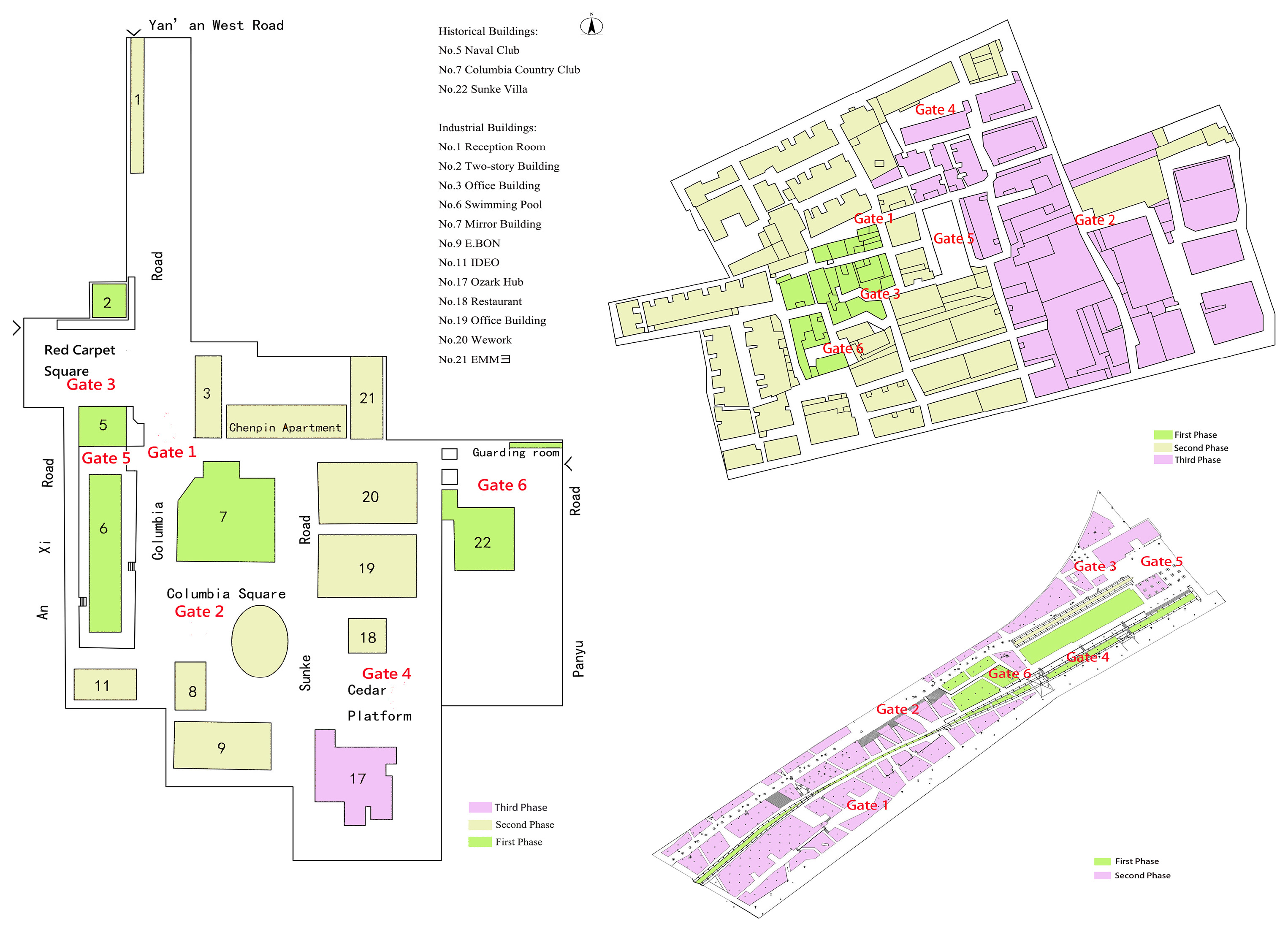
Figure 3 displays the current spatial configurations of the three cases. The green, yellow, and pink parts indicate buildings in the first, second, and third phases, respectively. Considering the spatial characteristics and different cultural phases, six gates were selected for data collection and analysis.
3.2. Data Collection
3.2.1. Space Syntax
In this study, the VGA model of space syntax was applied to analyze the spatial configuration of Columbia Circle using Depthmap Beta 1.0 software (a spatial analysis software originally developed by Alasdair Turner at the Space Syntax Group, UCL). VGA can be used to study the control and influence of localized spatial units in integral systems and explore their social logic [
29]. Thus, it is suitable for studying a heritage site on the mesoscopic scale with clear borders but not a complex layout.
The workflow proceeds as follows: (1) identify the research scope and core nodes; (2) select suitable models; (3) construct the spatial network’s structural relationships based on topological principles and calculate the urban service radius; (4) generate morphological variables to explore the relationship between a heritage space and its social functions.
In accordance with the scale and areas of the case, the grid properties were set to 10 (grid property = 10 corresponds to 1 m spacing) and the radii were set to n (for global integration) and 3 (for local integration). To avoid border effects, in this study the surrounding entrances and adjacent traffic roads of the case were set as boundaries (
Table 1).
Global integration, local integration, connectivity, control, and visual entropy were applied in this analysis. Global integration is a measure of general syntactic accessibility and is used to reflect the centrality of the integral spatial system [
19,
30]. The more integrated a space, the more accessible and central it is and the easier it is for people to gather there.
The formula for global integration (GI) is as follows (Ostwald, 2011 [
30]):
where n is the total number of visible nodes in the graph, and MVD (mean visual depth) is the average of the shortest visual distances from a particular node to all other nodes [
30].
Local integration (LI) refers to integration values at radius 3 (root plus 2 topological steps from the root), representing a localized picture of integration. LI can reflect the cultural representation of local heritage spaces. A high value tends to be a warm color and demonstrates higher visibility in a space.
The connectivity of a space is the number of surrounding spaces that are directly connected to it [
30,
31,
32]. This variable indicates the accessibility of spatial properties to the heritage’s culture [
33,
34]. The formula for connectivity is as follows [
30,
32]:
where k is the number of other nodes directly visible from a given node. Warm colors indicate high connectivity, and many local spaces can connect with spaces with high connectivity. Conversely, cold colors indicate low connectivity with other surrounding spaces.
Control indicates the interactive effects of a certain space with its surroundings. A high value of control indicates a close connection and the interaction between this space and its surroundings. The formula for control (CO) is as follows:
Warm colors indicate the strong influence of a space on its surroundings, while cold colors indicate a weak influence.
Visual entropy measures the distribution of spatial locations in terms of their depths [
35]. It indicates the order of a space. The lower its value, the more symmetric and dynamic the space. The formula for visual entropy (VE) is as follows [
36,
37]:
where d
max represents the maximum depth from vertex v, and P
d represents the frequency of point depth d from the vertex. Warm colors indicate high values and visual disorder, whereas cold colors indicate the opposite.
3.2.2. Questionnaire
The public questionnaire consisted of four parts, namely, the purpose of this study, cultural cognition dimension scoring, usage habitats, and respondent profile. Twenty-four questions based on the framework mentioned above were included to evaluate cultural cognition of heritage. Before the public survey, a pilot study was conducted, which provided feedback and amendments to ensure the applicability of the evaluated items. A five-point scoring scale (1 = strongly disagree; 5 = strongly agree) was used to score the degree of cognition. The collection period ranged from 29 March 2025 to 18 May 2026. In total, 655 questionnaires were collected on-site, 652 of which were valid after the test. To capture in situ cognition and eliminate selection bias, data were collected exclusively using on-site systematic random sampling. A fixed sampling interval (every 5th adult) was applied along predetermined walking routes that covered Tianzifang, Columbia Circle, the Start Museum, and their adjacent residential blocks. The starting point was randomly chosen for each session. This study aims to capture the diversity of users’ cognitions. The procedure was repeated on both weekdays and weekends, allowing us to include various backgrounds and ages.
Most respondents were between 19 and 65 years old and had different educational backgrounds. Most respondents had lived in Shanghai for 3–5 years or more than 10 years. Their presence in the study areas ranged from 1 to 3 times each week. These data demonstrate that the respondents had basic feelings toward this study area.
3.3. Data Analysis
Given the cross-sectional design and limited sample size of this study, an exploratory comparative case study approach was applied rather than pursuing causal inference. The analysis was conducted using Spearman correlations, and its primary focus was to identify and describe the relationships and patterns between spatial attributes and cognized dimensions, thereby generating hypotheses and providing direction for future confirmatory studies.
The analysis was performed in three steps. First, the spatial configuration data were normalized, as the floor plans of the three cases were at different scales. Second, a Spearman correlation coefficient analysis was performed for the three cases and the integral analysis. The dimensions of cultural cognition were set as the dependent variable, whereas the global integration, local integration, connectivity, control, and visual entropy of the selected gates were set as the independent variables. Second, a K-means clustering analysis was conducted to divide the selected gates into different revitalized patterns. All analyses were performed with SPSS version 26 software.
4. Results
4.1. Tianzifang
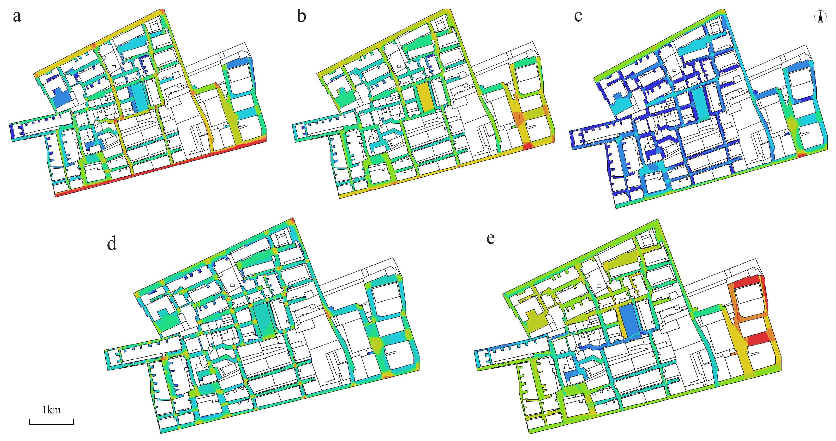
The spatial configuration results of Tianzifang are shown in
Figure 4. TZ4 displays the highest local integration and connectivity. This indicates that it is the most central and accessible node within Tianzifang’s internal network, functioning as a core hub for pedestrian movements.
TZ6 possesses the highest visual entropy and control. This suggests a location with rich visibility, likely an intersection of multiple alleys with dense commercial signage. Its high control value implies that it lies on the shortest path for significant pedestrian movement, making TZ6 a strategically important control point that is also visually complex. TZ3, as an entry point from the outside, has the highest global integration, suggesting superior accessibility.
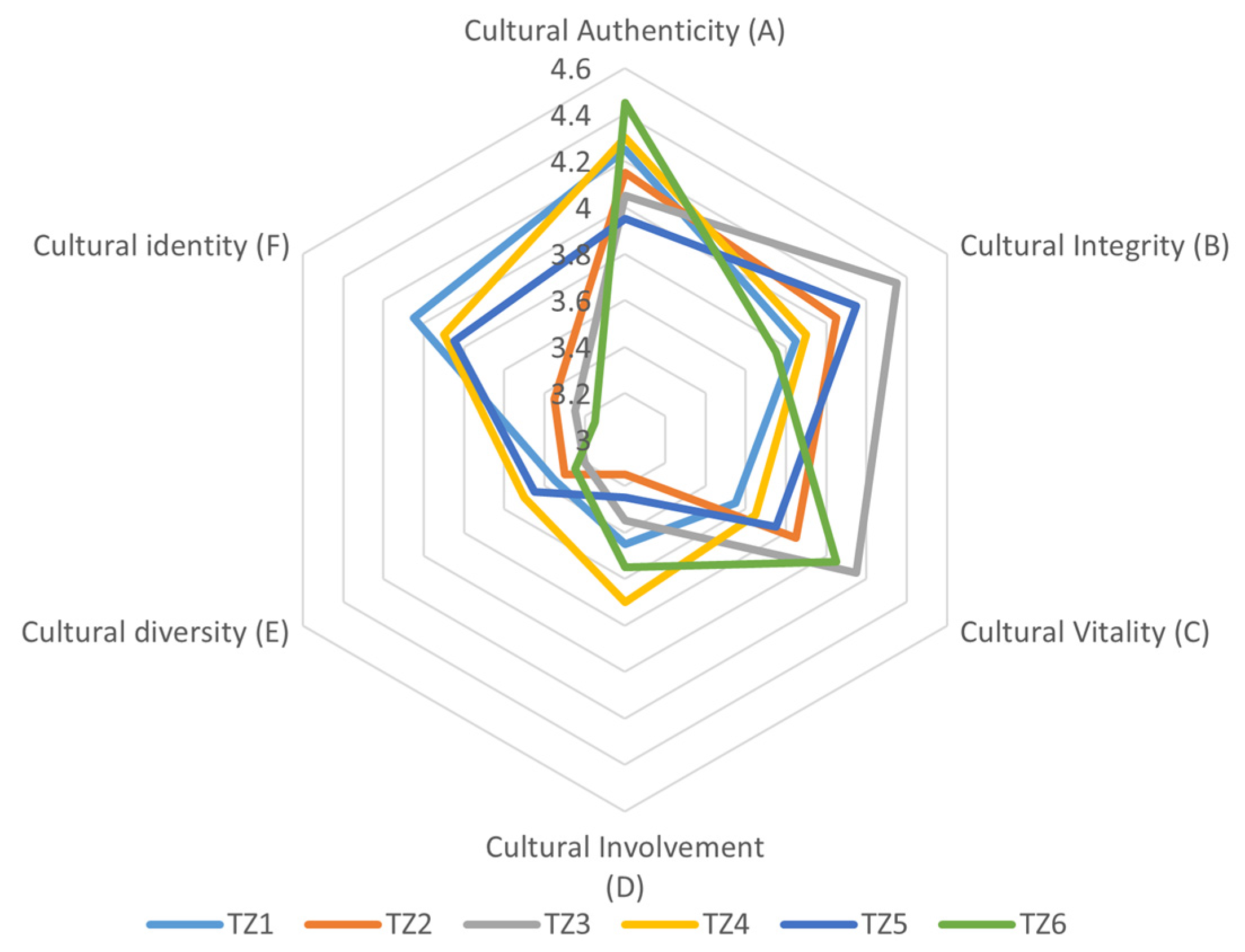
All observed gates scored high on cultural authenticity but varied significantly in vitality, involvement, and identity (
Figure 5).
TZ3 and TZ4 registered the highest scores for vitality and involvement. Specifically, TZ3 excelled in cultural integrity and vitality, while TZ4 led in involvement. As these points are relatively open small plazas at the intersections of main alleyways, they naturally become gathering points for pedestrian flow and activity, which significantly enhances their cognized vitality and participatory quality.
TZ6 scored highest in cultural authenticity but lowest in cultural identity. This paradox arises because it retains the most original, unaltered character. While the public acknowledges its authenticity, this state creates a sense of distance, hindering emotional resonance and identity. It functions more like a museum than a community space.
TZ1, located at the main entrance, achieved the highest score for cultural identity but the lowest for involvement. This is because individuals can strongly establish their identities; for example, I have arrived at Tianzifang but cannot yet deeply engage with the site’s activities.
The correlation analysis revealed that visual entropy has a significant positive correlation with cultural vitality but a significant negative correlation with cultural identity. This suggests that visual richness is interpreted as vitality, yet excessive visual complexity can undermine the public’s overall cognitive grasp of the place and its sense of emotional belonging. Local integration showed a positive correlation with cultural involvement, as the well-connected internal alleys encourage lingering, interaction, and consumption. Finally, connectivity was positively correlated with cultural diversity, as gates with more direct connections expose individuals to a wider variety of shops, galleries, and landscapes, enhancing their cultural cognition (
Table 2).
4.2. Columbia Circle
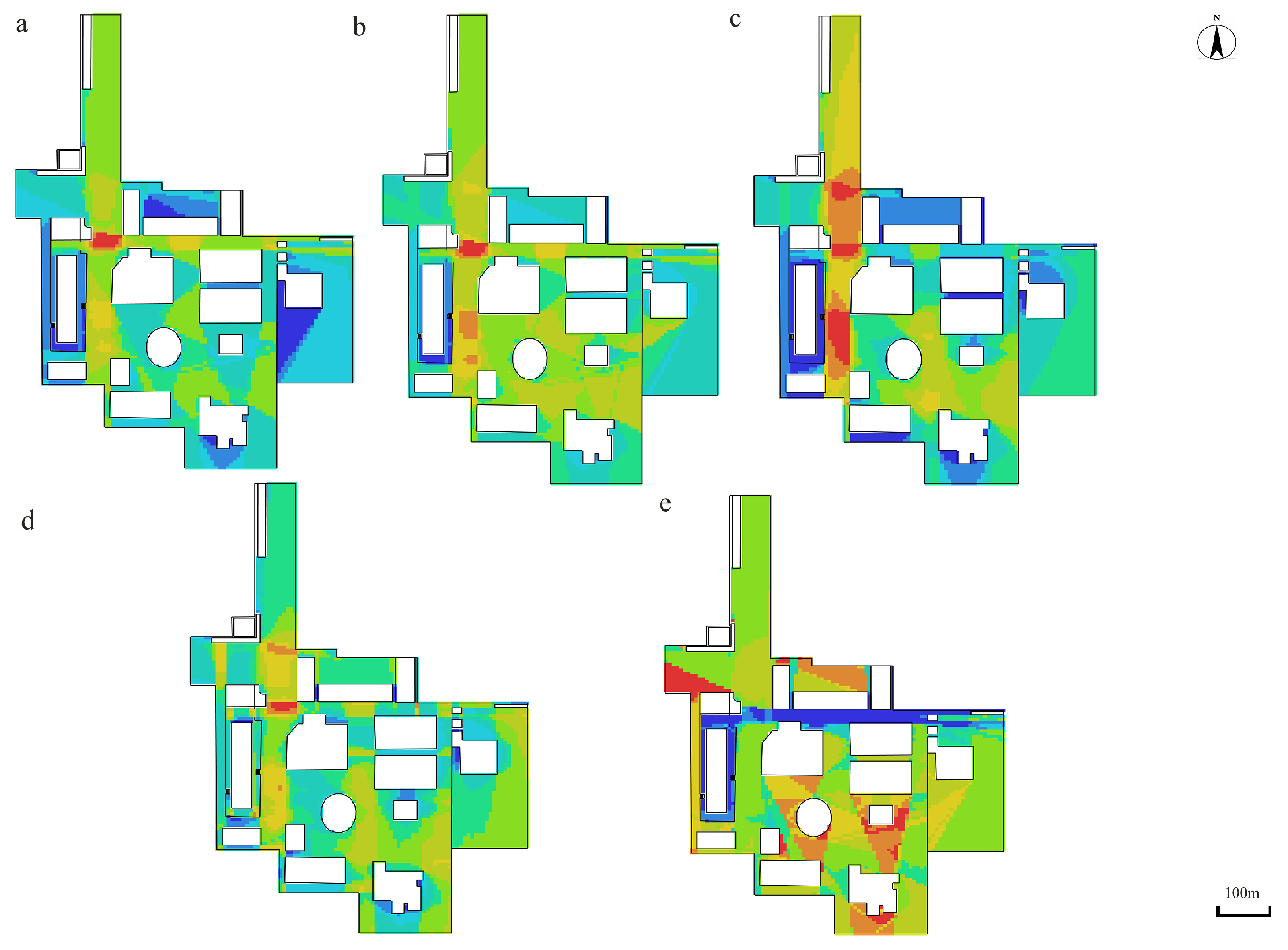
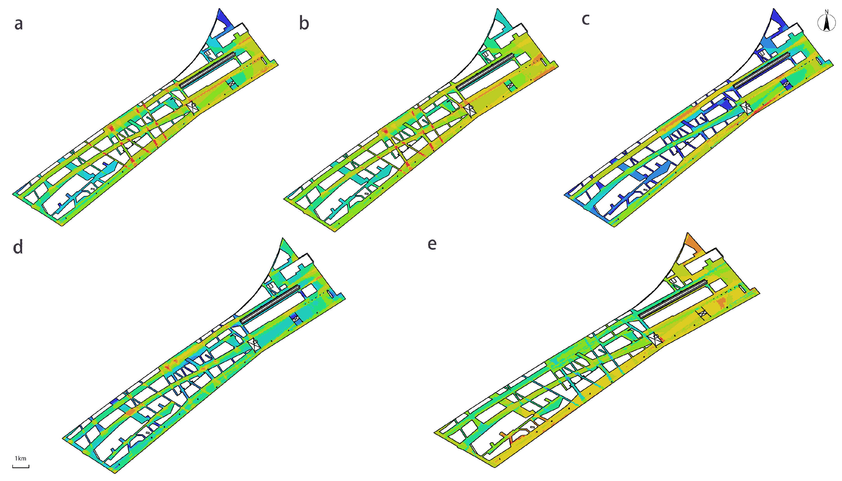
The spatial configuration results for Columbia Circle are shown in
Figure 6. CC1 displays the highest values for global integration, local integration, connectivity, control, and visual entropy, establishing it as the most dominant spatial location. It is the center of the entire site, where the most open, accessible, and visually permeable point connects the greatest number of surrounding locations. Conversely, CC5 registers the lowest values across all metrics. The data for the remaining gates clearly demonstrate a declining pattern from the core to the periphery.
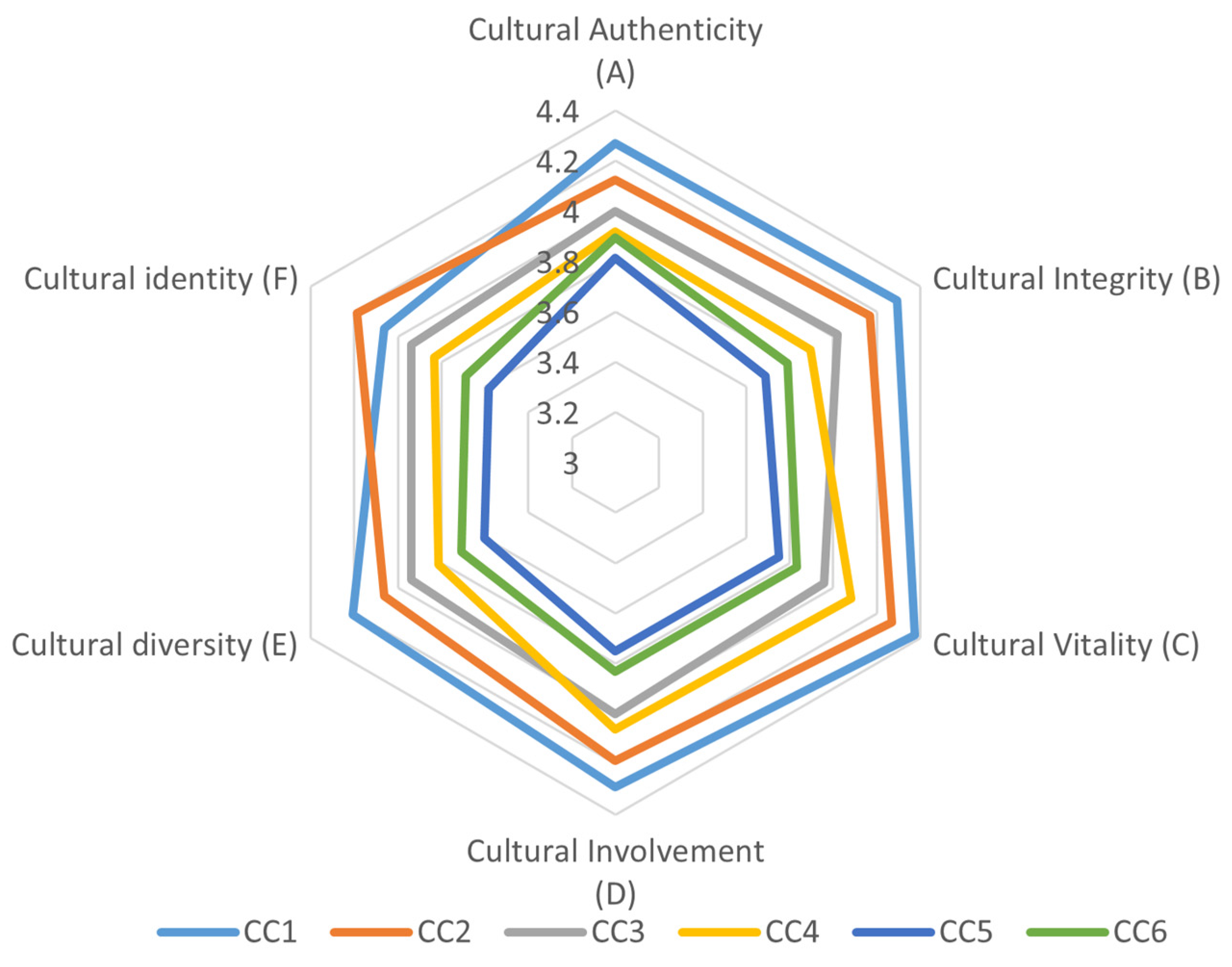
In terms of cultural cognition, CC1 achieved the highest scores for vitality, involvement, and diversity, underscoring the significance of its central location. CC5 scored the lowest across all dimensions because it is situated at the rear of the Navy Club and is an independent space. Its revitalization preserved most of its historical features, such as mosaic tiles, swimming lanes, and railings, resulting in a high authenticity score. However, due to its poor spatial accessibility, its cognized vitality and involvement are significantly diminished (
Figure 7).
The correlation analysis for Columbia Circle reveals that global integration, local integration, connectivity, and control are strongly correlated with authenticity, integrity, vitality, involvement, diversity, and identity. This indicates that the more central, accessible, and connected a gate, the higher the public’s comprehensive cultural evaluation of that gate (
Table 3).
Notably, the correlation between global integration and local integration is identical. This precisely captures the coherent, hierarchical spatial logic of Columbia Circle and identifies this place as a well-organized system in which the spatial hierarchy is coherent from the local to the global scale. The extremely high correlation between GI and LI at Columbia Circle is a direct and quantifiable reflection of its spatial structure as a “high-quality social hub.” Spaces with the highest integration with their immediate surroundings, such as the central plaza (CC1), are also the most accessible points from all other locations within the site (high GI), concentrating movement, interaction, and perception onto a dominant core. Conversely, peripheral and less-connected points (like CC5) are segregated at both the local and global levels. There are no “hidden” local centers that are globally isolated, nor are there global shortcuts that bypass local contexts.
4.3. The Start Museum
The spatial configuration results of the Start Museum are shown in
Figure 8. SM2 and SM4 possess high global integration, local integration, and connectivity, forming the primary movement routes of the site and marking where the original railway tracks and structures were retained. SM6 has the lowest visual entropy and, along with SM3, it exhibits lower integration and connectivity.
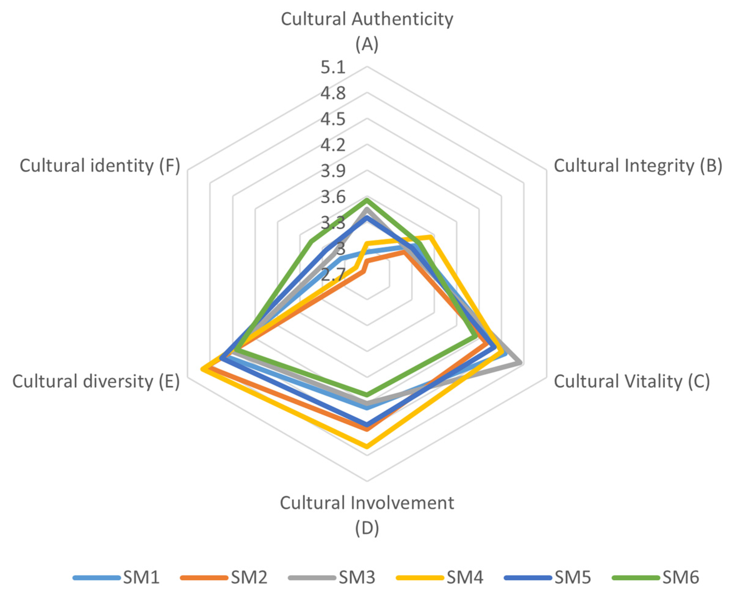
Regarding cultural cognition, the museum scored lowest in authenticity and identity but highest in vitality. SM2 and SM4 received the highest scores for involvement and diversity, while SM3 and SM6 scored lowest on authenticity and identity (
Figure 9).
The correlation analysis indicates that global integration, local integration, and connectivity are all positively correlated with cultural involvement and cultural diversity. This suggests that spaces with high accessibility and connectivity enhance the public’s spatial experience.
However, its visual entropy is positively correlated with cultural vitality; their correlation is 1.000. These perfect data precisely reveal the core logic of its revitalized function as a museum. The rank order of the visual entropy scores of the six points is identical to that of their cultural vitality scores. The point with the lowest visual complexity is cognized as the least vital, the second-lowest as the second-least vital, and so on, up to the highest-ranked point for both metrics. This is because the Start Museum’s revitalization fundamentally reconfigured the space to serve its new function as a museum. Its setting is highly minimalist and visually clean, where vitality is generated almost exclusively by curated art installations, architectural highlights, and intentionally designed points of interest. These are precisely the elements that increase visual information and, consequently, visual entropy at specific locations. Therefore, this perfect correlation strongly validates the hypothesis that, in a function-driven, minimalist heritage revitalization, visual complexity can become the dominant, or even sole, driver of perceived vitality (
Table 4).
4.4. Influence of Spatial Configuration on Cultural Cognition After Heritage Revitalization
After comparing the three cases, we found that Tianzifang is internally cohesive and visually complex but relatively isolated from its external settings (
Table 5). Columbia Circle is hierarchically structured, with a highly open core and a relatively enclosed periphery. The Start Museum features strong internal–external connectivity, clear pathways, and low visual interference, with its revitalized form directly serving its core function as a museum.
Tianzifang has the lowest global integration, high internal variance in local integration, highly variable visual entropy, and low connectivity and control, yet it scores highest in cultural authenticity and lowest in involvement. This points to an introverted spatial character. Its internal network is highly connected and active, and its visual field is irregular, complex, and information-rich. This structure provides the public with a slow and exploratory experience. The space in this structure is the core of the cultural attraction.
Columbia Circle shows the highest global integration, connectivity, and control but lower and more concentrated visual entropy values than Tianzifang. It scores high in vitality, integrity, and involvement, indicating more regular and orderly public open spaces.
The Start Museum has high global integration, local integration, and connectivity but the lowest visual entropy and control. It scores high in vitality, diversity, and involvement but extremely low in authenticity and identity. This signifies a space that is concise, open, and visually permeable, with gates connecting numerous spaces for maximum accessibility. The revitalization was primarily driven by its new function as a museum. Although certain cultural features of the original site were retained, the underlying logic of its spatial functions was fundamentally reconfigured.
4.5. Patterns of Cultural Cognition After Heritage Revitalization
Through cluster analysis, the 18 observation points can be categorized into three distinct types (
Table 6):
a. The authentic traditional revitalized area.
High visual complexity underpins historical authenticity and integrity, but low integration and control lead to a loss of vitality and involvement. All six gates in Tianzifang, along with CC4 and CC6, fall into this pattern. This demonstrates that spaces with low control, low connectivity, and high visual richness preserve a sense of historical authenticity. However, their narrow alleys and low global accessibility limit deep public engagement and hinder the injection of contemporary vitality.
b. The high-quality social hub.
CC1, CC2, CC3, and CC5 represent this model. High global integration and connectivity establish the space as the center of a community network, thereby supporting growth across all dimensions of cultural cognition. High connectivity is the key attribute, including central plazas, primary intersections, and public service nodes. They constitute hubs of community life, concentrating pedestrian flow, mixed functions, and social interactions. High global integration signifies that these gates are not just local centers but also gateways to the entire system, easily reachable from any point.
c. The functional and vital art container.
All six gates at the Start Museum exemplify this pattern. It primarily uses high control, low connectivity, and low visual interference to create an extraordinary experience, thereby stimulating vitality, involvement, and diversity. However, this space completely divests its historical authenticity and identity.
5. Discussion
The comparative analysis of Tianzifang, Columbia Circle, and the Start Museum reveals that the spatial configuration of revitalized heritage sites is not merely a neutral physical container but an active, determinative force that shapes psychological and cultural cognition. By integrating spatial syntax metrics with multidimensional cultural cognition data, this study found that the spatial attributes designed to maximize contemporary functional efficiency and organized vitality frequently operate in direct opposition to the preservation of historical authenticity and cultural identity. Through the lens of the three distinct models identified in the clustering analysis, this discussion unpacks the complex trade-offs inherent in heritage revitalization (
Table 7).
5.1. The Dual Properties of Visual Entropy: Authenticity Versus Alienation
The spatial data from Tianzifang highlight the complex role of visual entropy in heritage settings. In environmental psychology and spatial syntax, high visual entropy denotes spatial irregularity, visual clutter, and complex lines of sight. The results indicate that Tianzifang possesses the highest visual entropy, combined with low global integration but highly variable local integration, and creates a highly introverted spatial morphology.
The correlation analysis reveals a fascinating psychological characteristic: although this high visual complexity is inherently linked to high cultural authenticity and cultural vitality, it exerts a significant negative impact on cultural identity. This is because the high visual entropy, due to the narrow alleys, dense signage, and layered historical textures, forces the public to slow down and visually engage with the physical fabric. Thus, it validates the site’s age and unpolished reality and guarantees an exploratory, serendipitous experience, which is interpreted as “vitality.”
However, when visual entropy crosses a certain threshold without the balancing effect of high global integration, a space becomes illegible. According to Kevin Lynch’s theories of urban legibility, when users cannot easily map or navigate an environment, their sense of spatial mastery diminishes [
16]. As the data for TZ6 demonstrate, its excessive complexity alienates the public. The space, while historically authentic, transforms into a chaotic spectacle to be observed rather than a community space to belong to. Consequently, the public struggles to develop a deep emotional resonance or territorial attachment, resulting in a loss of cultural identity [
38].
5.2. Influence of Centrality: Spatial Hierarchy as a Holistic Catalyst
Compared with Tianzifang, Columbia Circle demonstrates a clear spatial hierarchy. The CC1 data are unparalleled because it possesses the highest global integration, local integration, connectivity, and control across all 18 samples, rendering it an essential position.
Crucially, the correlation analysis for Columbia Circle shows that these metrics of spatial configuration share a very positive correlation with all cultural cognition dimensions, including authenticity, integrity, vitality, and involvement. This challenges the assumption that modernization necessarily degrades historical cognition. It proves that a space with high legibility and accessibility can be a “social condenser.”
5.3. The Cost of Control: Functional Implantation and Historical Erasure
The Start Museum exhibits a highly efficient spatial network, characterized by high global and local integrations, very high connectivity, and the lowest visual entropy. This spatial logic is entirely driven by its newly assigned function as an art gallery, creating clear, obstruction-free circulation routes for consuming art.
However, the correlation results expose a stark psychological trade-off. High spatial control and high integration have a strong positive correlation with modern involvement and diversity, but a severe negative correlation with “cultural authenticity” and “cultural identity.” This indicates that the process of structurally optimizing and highly controlling a heritage site to dictate a specific narrative simultaneously strips away its organic ambiguity and multi-layered spatial memories. The low visual entropy creates a “white cube” effect. While this spatial neutralization is functionally successful for a museum, it severs the human connection to the place itself. Visitors recognize the space as an efficient, highly active contemporary container, but they can no longer perceive its soul, resulting in the lowest scores for historical identification. The spatial configuration proves that when functional efficiency becomes paramount, historical identity is often spatially erased.
5.4. Heritage Revitalization Implications
The clustering analysis categorizes the spatial-cognized relationships into three distinct models of revitalization. For urban planners and architects, these findings suggest that spatial interventions must be precisely tailored to the specific cultural goals of a revitalization project.
For projects that prioritize preserving historical atmospheres, designers should deliberately maintain high visual entropy, such as rich textures and complex streetscapes, and rely on local integration rather than drastically opening the area to the global urban grid. However, to mitigate the current lack of “involvement,” micro-interventions should focus on improving the connectivity of internal minor nodes, such as small plazas or intersections, to create localized gathering spaces without destroying integral feelings.
When the goal is to create a vibrant community, maximizing global integration and connectivity is paramount. Designers should establish a clear spatial hierarchy with a strongly defined, highly accessible center, for example, a central plaza, to effectively blend preservation with modern social mixing.
If a heritage site is undergoing a complete functional replacement, designers can utilize high control and low visual entropy to create a highly efficient, distraction-free environment. While this guarantees high visitor participation and modern vitality, planners must be acutely aware that the spatial memory has been spatially neutralized. Therefore, to compensate for the loss of “cultural identity,” the site must rely heavily on high-quality external cultural injections, like exhibitions and events, rather than the spatial fabric itself to attract the public.
6. Conclusions
This study demonstrates that, in urban heritage revitalization, spatial configuration is not a mere neutral backdrop but a highly active determinant of human experience. By quantifying how spatial attributes are recalibrated during revitalization, we visualize and measure the hidden physiological cognition of heritage.
By linking space syntax metrics to six dimensions of cultural cognition, we show that global integration, local integration, and connectivity are the strongest predictors of positive public cognition. Furthermore, our three spatial–cultural typologies illustrate how specific morphological interventions dictate whether a site preserves its historical identity, fosters social mixing, or serves solely as a modern functional vessel. These findings advance urban design theory by demonstrating that morphological variables can serve as leading, quantifiable indicators of cultural impact, effectively moving the discourse of space and culture from an abstract metaphor to an empirically testable framework.
However, the limitations of this study must be acknowledged, as the research is currently at a primary stage. The principal limitation is the relatively small sample size. Consequently, the statistical correlations and clustering results presented herein highlight aggregate-level patterns, and they represent an exploratory analysis rather than definitive causal claims at the individual psychological level. Future work must include a significantly larger number of cases to make the statistical analysis more robust, reliable, and reproducible. Additionally, subsequent steps should incorporate multilevel models and complementary qualitative techniques to further extract the deeper connotations of heritage sites and better understand public cognition.