Article

Enhancing Public Space Vitality in Traditional Villages: A Space–Event Analytical Framework Applied to Yutu Village, China

1
School of Arts and Communication, China University of Geosciences, Wuhan 430074, China
2
School of Architecture and Urban Planning, Huazhong University of Science and Technology, Wuhan 430074, China
3
School of Computer Science, China University of Geosciences, Wuhan 430074, China
*
Author to whom correspondence should be addressed.
Land 2026, 15(7), 1223; https://doi.org/10.3390/land15071223
Submission received: 5 June 2026 / Revised: 28 June 2026 / Accepted: 3 July 2026 / Published: 7 July 2026

Abstract

Public space vitality is increasingly regarded as a central issue in the conservation and renewal of traditional villages, yet existing studies rarely combine spatial pattern analysis with residents’ perceptual evaluation within a single framework. Taking Yutu Village in southeastern Hubei, China, as a case, this study develops a Space–Event analytical framework integrating GIS-based spatial statistics with Importance–Performance Analysis (IPA). Semi-structured interviews, participatory mapping, and questionnaire surveys identified 58 public event units, 34 physical public spaces, and 241 event–space coordinate points. Kernel density estimation (KDE) and Ripley’s K-function analysis indicate a composite structure of one core, multiple centers, four axes, and five clusters. Historical and cultural events cluster around heritage buildings, daily life and production events extend along everyday movement corridors up to 155 m, and ritual and folk cultural events remain concentrated at small-scale ceremonial nodes. Based on 112 valid questionnaires, IPA-based evaluation shows negative gaps between importance and satisfaction across all 23 indicators (p < 0.001 for all items), with spatial narrative showing the largest gap (Δ = −1.66), while ritual-related indicators achieve the highest satisfaction scores, suggesting a degree of cultural resilience in ceremonial spaces. By cross-referencing spatial clustering types with IPA quadrants, the study proposes differentiated strategies, including narrative-oriented design for heritage spaces, connectivity enhancement for everyday networks, and protective maintenance for ritual nodes, offering an evidence-based framework transferable to comparable traditional village contexts.

1. Introduction

Traditional villages are fundamental carriers of regional culture and historical memory, and their public spaces actively support daily production, social interaction, and cultural continuity [1,2,3,4,5]. Spaces such as ancestral halls, public squares, ponds, streets, and sacred sites condense historical events, collective rituals, and everyday practices, functioning as critical arenas for rural cultural reproduction. International experience in rural revitalization underscores that sustaining such spaces requires more than physical improvement. France‘s LEADER program demonstrates the value of bottom-up, community-led resource activation [6,7,8], Germany’s Dorferneuerung highlights the importance of pairing physical upgrading with socio-cultural conservation [9,10], and Japan’s One Village One Product illustrates the power of amplifying distinctive local assets to sustain community identity [11,12]. Across these cases, public space vitality rests on the activities a space hosts and on community participation rather than on physical form alone.
In China, the renewal of public spaces in traditional villages has emerged as a critical policy priority under the national Rural Revitalization Strategy [13]. In practice, however, many projects still predominantly focus on physical renovation and landscape beautification [14]. Although physical spatial quality has improved in many instances, genuine public space vitality has not necessarily increased. The revival of traditional events and the reactivation of everyday social interaction often remain limited. This practical mismatch raises a central research question: how are different categories of events spatially distributed across village public spaces, and how do those spatial patterns relate to residents’ actual perceptions of vitality?
Existing studies increasingly recognize that rural public space is not merely a physical container but a socially produced setting continuously (re)produced through recurring events, embodied practices, and local social relations [15,16,17,18]. Previous research has examined rural public space vitality primarily through the lenses of physical optimization, cultural imagery construction, and governance or participation mechanisms [19,20,21]. Yet relatively little attention has been directed toward analyzing how different categories of events are distributed across village public spaces or understanding how those objective spatial patterns correspond to residents’ subjective evaluations of use, meaning, and overall satisfaction. This gap is particularly significant in traditional villages, where public space vitality depends on the coexistence of historically anchored events, everyday activities, and ritual practices within small-scale, culturally layered settings.
To address this issue, this study develops a Space–Event analytical framework that integrates GIS-based spatial statistical analysis with Importance–Performance Analysis (IPA); the framework and its theoretical basis are detailed in Section 3.1. Using Yutu Village as an empirical case, the study pursues three objectives: (1) to identify the spatial clustering patterns of event-based public spaces through kernel density estimation (KDE) and Ripley’s K-function analysis; (2) to evaluate villagers’ perceptions of public space vitality across six event–space categories using IPA; and (3) to cross-reference these spatial clustering types with IPA results in order to clarify differentiated planning directions for vitality enhancement. By linking structural spatial configuration with perception-based evaluation, which previous research has typically examined separately, the study provides a village-scale analytical basis for more precise and culturally responsive public space renewal in traditional settlements.

2. Literature Review

2.1. Public Space Vitality: From Urban Theory to Rural Application

In urban studies, public space vitality is fundamentally associated with diversity, density, human scale, and the capacity to sustain public life [22,23,24]. Early scholarship approached vitality through spatial morphology, functional mix, and the ability of built environments to support human needs and everyday activities [25,26,27]. More recent studies have further operationalized vitality through accessibility, behavioral diversity, dwell time, land-use mix, multisource urban data, and spatiotemporal activity indicators [28,29,30,31,32,33,34]. This transition from normative discussion to measurable assessment has firmly established vitality as both a spatial and a socio-behavioral concept.
However, methods developed in urban contexts cannot be transferred directly to traditional villages. Urban vitality indicators often emphasize activity intensity, pedestrian flow, facility provision, or observable behavioral frequency, whereas rural public spaces are shaped by slower temporal rhythms, collective memory, lineage relations, and ritual practices [35,36,37,38,39,40,41,42]. In traditional villages, plazas, ancestral halls, ponds, streets, and sacred sites are not merely physical facilities; they are socio-cultural settings where everyday practices, collective rituals, and local identities are continuously reproduced. Rural public space vitality, therefore, cannot be reduced to use intensity alone but must be understood through the coupling of spatial morphology, collective practice, and local social structure.
Within the Chinese context, research on rural public spaces has shifted from a primarily material perspective toward a broader concern with cultural resources, residents’ experience, behavioral adaptation, and public-space quality in traditional villages [43,44,45,46,47,48,49,50,51]. Existing studies have quantified village public space vitality across spatial, ecological, cultural, and facility dimensions and have proposed renewal strategies focused on spatial design, cultural identity, and heritage activation. Despite these advances, previous research still tends to examine cultural interpretation, spatial configuration, and residents’ evaluation as separate issues. Limited attention has been paid to how different types of events are distributed across village public spaces and how these event-based spatial patterns correspond to residents’ perceived importance and satisfaction. This gap motivates the Space–Event perspective discussed in the following section.

2.2. Space–Event Theory and Its Application in Rural Contexts

The Space–Event perspective emerged from critiques of viewing space as a neutral physical container. Lefebvre emphasized that space is produced through social practice and lived experience [52]. Rossi highlighted the role of urban artifacts and historical continuity in collective memory, suggesting that spatial forms can carry accumulated social and cultural meanings [53]. Tschumi further argued that architecture should be understood through the interaction of space, event, and movement, rather than through form or function alone [54]. Together, these theories provide a basis for understanding public space as a dynamic setting in which social activities, memories, and spatial forms are mutually constituted.
Subsequent scholarship extended these ideas to public spaces and cultural landscapes, emphasizing the interaction among human activities, temporality, and spatial structure [55,56]. Events are therefore not merely activities that occur within space; they can activate spatial meaning, reshape use patterns, and reinforce collective experience. Studies of urban festivals, street performances, and temporary public-space interventions have shown that events can transform both the functional and symbolic dimensions of public space [57,58]. This literature supports the view that space and events should be analyzed as mutually constitutive.
In rural contexts, however, event-related research remains comparatively fragmented. Existing studies have examined rural arts festivals, public perceptions of festival activities, folk-belief spaces, and interaction rituals in tourism contexts [59,60,61,62,63]. These studies demonstrate that rural events are important for place identity, cultural representation, and social cohesion. Yet they often focus on single event types or specific cultural settings, with limited attention to how different categories of events are distributed across village public spaces or how they interact with spatial structure. This limitation is especially important in traditional villages, where folk rituals, lineage practices, everyday production, and collective memory are embedded in the same spatial system.
Overall, the literature reveals three limitations that are especially relevant to this study. First, public space vitality is still often conceptualized through use intensity, facility provision, or population density, with insufficient attention to how event structure and cultural memory contribute to spatial vitality. Second, research on rural public spaces has rarely examined how different event types generate distinct spatial distribution patterns within the same village. Third, few studies have integrated objective spatial analysis with residents’ perceptual evaluation in a unified framework capable of informing spatially differentiated renewal strategies. These limitations point to the need for an analytical framework that links event types, spatial distribution, and residents’ perceptual evaluation within the same village-scale analysis.

3. Methodology

3.1. Space–Event Analytical Framework

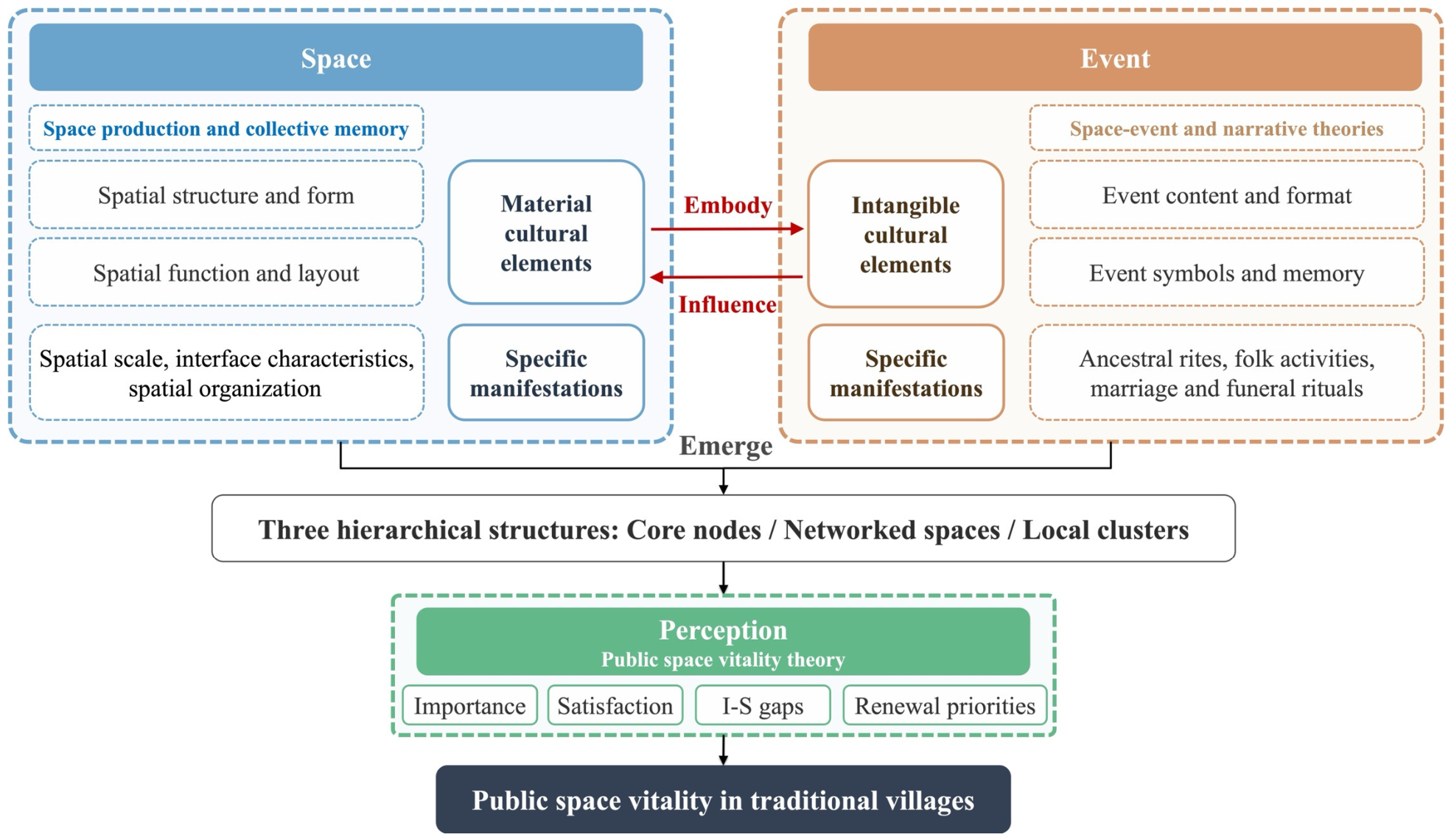
The proposed analytical framework integrates three theoretical strands: public space vitality, the Space–Event perspective, and theories of space production, collective memory, and spatial narrative. Vitality theory defines what should be evaluated, including spatial use, social meaning, and residents’ perceptions. The Space–Event perspective, together with theories of space production, collective memory, and spatial narrative, explains how social practices, historical narratives, and cultural memory become embedded in physical settings. Events, therefore, serve as the analytical bridge connecting physical space, social practice, and residents’ perceptual evaluation.
As illustrated in Figure 1, the framework is organized around the coupling between the spatial and event dimensions, with perception incorporated as an evaluative dimension. The spatial dimension encompasses physical structure, functional capacity, scale, and material heritage carriers. The event dimension comprises activity content, social actors, temporal rhythms, and symbolic meanings tied to collective memory and ritual practice. The perception dimension captures residents’ evaluations of importance and satisfaction, thereby identifying vitality gaps and renewal priorities. Through Space–Event coupling, different public-space patterns emerge, including core nodes, networked spaces, and local clusters. Building on this foundation, two propositions guide the empirical analysis: (P1) event-based public spaces exhibit statistically significant, category-specific spatial clustering rather than random distributions; and (P2) residents’ importance and satisfaction evaluations reveal significant gaps across event–space typologies, with the largest gaps likely occurring in spaces carrying strong historical and cultural significance.
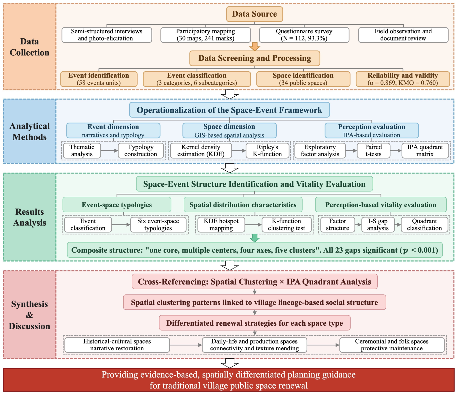
A sequential and complementary mixed-methods design was adopted because the framework requires three types of empirical evidence: qualitative narratives to identify event meanings and categories, participatory mapping and GIS analysis to examine spatial clustering, and IPA to evaluate residents’ perceived importance and satisfaction. As illustrated in Figure 2, the workflow proceeded in three distinct phases. First, semi-structured interviews, photo-elicitation, field observations, and participatory mapping were utilized to identify event units, physical public spaces, and spatial coordinate points. Second, the event and spatial data were processed through systematic event classification, kernel density estimation (KDE), and Ripley’s K-function to examine category-specific spatial clustering. Finally, the questionnaire data were analyzed through reliability and validity tests, exploratory factor analysis, paired-sample t-tests, and IPA quadrant analysis to evaluate the gaps between villagers’ perceived importance and actual satisfaction. Within this workflow, P1 is examined through KDE and Ripley’s K-function analysis of the event–space coordinate points, whereas P2 is examined through paired-sample tests and IPA based on the questionnaire responses. The spatial statistical outcomes and IPA results were subsequently cross-referenced to formulate spatially differentiated renewal strategies.

3.2. Study Area

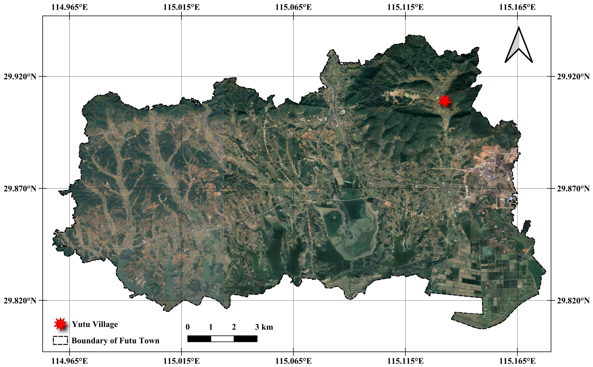
Yutu Village lies in Futu Town, Yangxin County, in southeastern Hubei Province, China (Figure 3). The site has been inhabited since the Song and Yuan periods, but its present form was shaped by the Li lineage, whose founding ancestor migrated from Jiangxi in the Ming dynasty and whose descendants settled the present site by the late Ming to early Qing (Li Clan Genealogy). Nestled between Huanggu and Baifo Mountains, the village exemplifies the traditional siting philosophy of leaning against mountains and facing water; it spans about 3.6 km2 and preserves over 40 Ming and Qing residences among its 230 buildings. As the lineage expanded southeastward, it differentiated into three branches (Taixinwu, Baimenlou, and Lijiajing), forming the configuration known locally as “one surname, three branches, and seven ancestral halls.” Today, the village comprises four natural hamlets, and of the seven historical halls, five survive, namely the Li Clan Ancestral Hall and the Baimenlou, Taixinwu Old, Taixinwu New, and Lijiajing branch halls.
Yutu Village was selected as an illustrative case because it embodies the spatial morphology and cultural assets typical of the region‘s lineage settlements while facing pressures common to many traditional villages, including fading cultural memory, low resident participation, and declining public-space vitality. Its rich genealogical records, surviving Ming and Qing architecture, and accessible resident community enabled the integrated fieldwork. Recognized for its exceptional historical and architectural value, the settlement was designated as a National Traditional Village in 2012 and holds multiple provincial heritage titles, including the protection of the Li Clan Ancestral Hall and the local intangible cultural heritage of traditional oil noodle craftsmanship. The physical environment supporting these cultural assets comprises three main categories of public space (Table 1). Traditional architecture embodies Confucian hierarchical principles and spiritual symbolism. Concurrently, streets, alleys, and squares adapt to the local topography to facilitate public gatherings and anchor collective memory. Furthermore, landscape features such as ponds, ancient wells, and farmland cater to livelihood needs and serve as vital platforms for everyday social interaction and cultural continuity.

3.3. Data Collection and Processing

The dataset consists of qualitative interviews and field-observation materials for event identification, participatory-mapping coordinate data for GIS-based spatial analysis, and questionnaire data for IPA.

3.3.1. Semi-Structured Interviews and Participatory Mapping

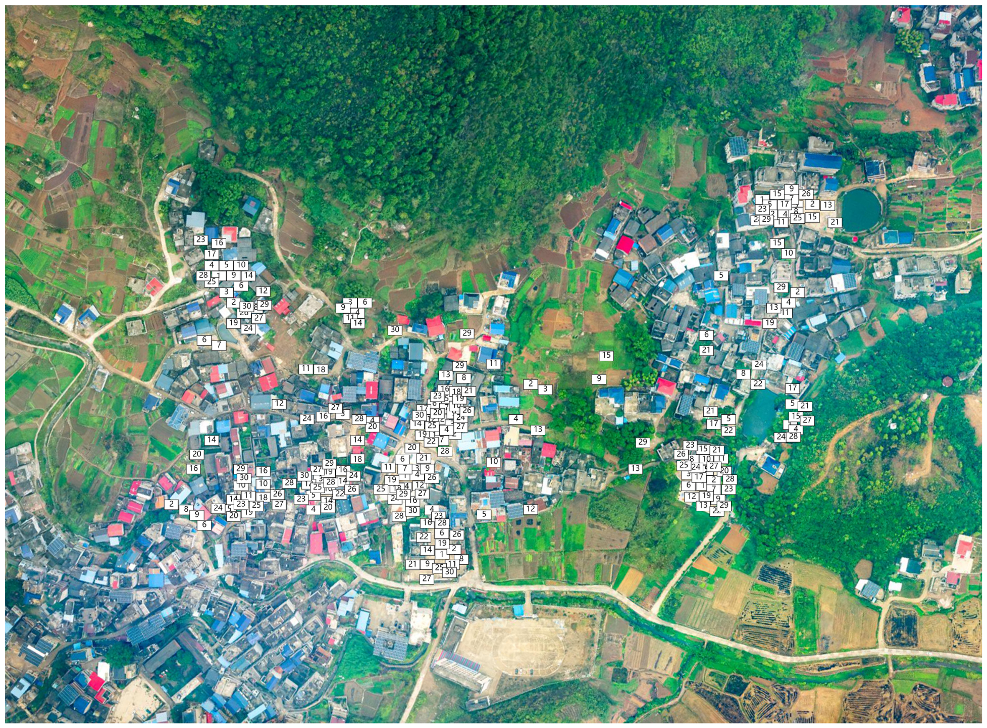
Fieldwork integrating semi-structured interviews (Table 2), photo-elicitation, and participatory mapping was conducted to identify public spaces and their associated events. Over two days in October 2024, 30 individuals were purposively selected to ensure diverse representation across age groups, residential areas, and residency statuses, including long-term residents, short-term residents, and visitors familiar with the village. Participation required a strong familiarity with the village and a willingness to complete the mapping task. Working from a base aerial photograph during daylight hours, participants marked the locations of recalled events and routine activities. These individual records were subsequently consolidated into 241 event–space coordinate points (Figure 4) to serve as the empirical foundation for the spatial analysis (Section 3.4).

3.3.2. Questionnaire Survey

An on-site questionnaire was used to evaluate villagers’ perceptions of public space vitality. The indicator system was developed in two steps. First, candidate indicators were adapted from established public space vitality and quality frameworks. Second, these indicators were contextualized according to the preliminary qualitative materials collected through interviews, photo-elicitation, and field observations; the corresponding interview results are reported in Section 4.1. The final questionnaire included 23 indicators covering dimensions such as spatial narrative, heritage conservation, facility support, cultural engagement, ecological quality, and ritual practice. Each indicator was rated for both importance and satisfaction on a five-point Likert scale.
For elderly or low-literacy respondents, survey assistants administered the questionnaire orally. To minimize interviewer bias, assistants read each item verbatim from the printed questionnaire, used the same five-point Likert scale wording, and avoided prompting or suggesting answers. Only procedural clarifications, such as how to choose a scale score, were allowed. While minor variation in supplementary explanations could not be entirely eliminated, the high internal consistency of the responses suggests this did not substantially compromise data quality.
A total of 120 questionnaires were distributed, yielding 112 valid responses for an effective rate of 93.3%. The sample profile broadly aligned with field observations and the known demographic composition of the village (Table 3). Specifically, long-term residents comprised 76.79% of the sample, respondents aged 36 and older accounted for 70.54%, 74.11% had attained a junior high school education or below, and 58.93% were engaged in farming or migrant labor. Because the village committee maintains only aggregate demographic figures (approximately 370 households and over 1760 residents), the consistency of the sample with the resident profile was assessed through field observation and committee consultation rather than a precise census comparison. The dataset’s internal consistency and suitability for factor analysis were indicated by a Cronbach’s α coefficient of 0.869, a Kaiser-Meyer-Olkin (KMO) value of 0.760, and a significant Bartlett’s test of sphericity.

3.3.3. Event Identification and Classification

Through the consolidation of interview narratives, field observations, and participatory mapping records, 58 public event units were identified and, where possible, associated with specific spatial locations. The reported figures of 58 events, 34 public spaces, and 241 coordinate points refer to different analytical units rather than to a one-to-one correspondence. The 58 events are narrative units distilled from interview accounts, comprising 49 collective-memory events and 9 individual biographical narratives. The 34 public spaces are unique physical locations identified from the field survey. The 241 coordinate points are raw mapping marks generated by participants and were retained in their non-aggregated form for density-based spatial analysis because repeated marks indicate the perceived salience of particular places. After spatial de-duplication, these marks corresponded to 196 distinct mapped coordinate positions, with a maximum of six coincident marks at a single node. Thus, one event may be associated with multiple spaces, and a single space may host or be remembered through multiple events.
The classification of these events was informed by Getz’s event typology framework [64], which categorizes activities based on functional characteristics and purposes. Because activities in traditional villages are shaped simultaneously by event content, temporal rhythm, spatial setting, and social actors, the classification criteria integrated both functional and contextual attributes. The 58 events were therefore organized into three primary categories: historical and cultural events, daily life and production events, and ritual and folk cultural events. These categories were further subdivided into six subcategories: historical commemoration, cultural heritage, daily life, agricultural production, ritual practices, and folk customs. The full classification results are reported in Section 4.1.

3.4. Analytical Methods

Following event identification and classification, the empirical analysis proceeded in two primary stages. The first stage involved the spatial analysis of event distributions using GIS-based methods, while the second stage focused on a perception-based evaluation of public space vitality.

3.4.1. GIS-Based Spatial Analysis

A total of 241 event–space coordinate points derived from the participatory mapping exercise were digitized and imported into ArcGIS 10.8 (Esri, Redlands, CA, USA) for analysis. Two complementary spatial statistical methods were subsequently applied.
KDE: This method identifies event hotspots across the settlement. It converts discrete point data into a continuous density surface, highlighting areas with intense event concentrations. The kernel density estimate at any location s is defined as:
f ^ s = 1 n h 2 i = 1 n K ( s s i h ) ,
where n represents the total number of event points, h denotes the bandwidth or search radius, s i indicates the location of the i-th event point, and K ( · ) serves as the kernel function. A 30 m search radius was used to represent micro-scale pedestrian activities and the compact spatial fabric of the traditional village. High-density zones indicate nodes where multiple events overlap. This method was applied to both the full dataset and the three event categories for comparative analysis.
Ripley’s K-function: While KDE visualizes spatial concentration, it does not by itself establish whether the observed pattern departs from spatial randomness. Ripley’s K-function was therefore used to examine clustering across different spatial scales. The function is defined as:
K ^ d = A n ( n 1 ) i i j I ( d i j d )
where A represents the area of the study region, n is the number of event points, d specifies the distance threshold, d i j is the distance between event points i and j , and I ( · ) is an indicator function that equals 1 when the condition is met and 0 otherwise. The observed curve was compared with the expected curve under complete spatial randomness. Confidence envelopes generated under complete spatial randomness were used to assess whether the observed distribution showed statistically significant clustering at different distance thresholds.

3.4.2. Perception-Based Evaluation Using IPA

IPA was adopted to evaluate the gap between villagers’ expectations and the current conditions of local public spaces. Originally developed for marketing research [65], this diagnostic framework is widely utilized in urban planning and community development to identify priority areas for spatial intervention.
The evaluation system comprised 23 indicators mapped onto the six event–space subcategories identified through event classification and the fieldwork phase (Table 4). These indicators assessed multidimensional vitality attributes, including spatial narrative, heritage conservation status, facilities support, ecological condition, legibility, and cultural engagement. Respondents rated both the perceived importance and the actual satisfaction for each indicator using a five-point Likert scale.
The analytical procedure consisted of three steps. First, exploratory factor analysis, using PCA with Varimax rotation, was conducted to examine whether the factor structure of the 23 indicators aligned with the six predefined event–space categories. Factors with eigenvalues greater than 1.0 were retained. Second, paired-sample t-tests were used to assess whether the gaps between importance and satisfaction scores were statistically significant at the indicator level. Finally, an IPA quadrant matrix was constructed. The grand means of all importance and satisfaction scores served as the intersection axes. This framework classified the indicators into four quadrants: Quadrant I represents “keep up the good work”, characterizing high importance and high satisfaction; Quadrant II implies “possible overkill,” showing low importance and high satisfaction; Quadrant III indicates “low priority”, with low importance and low satisfaction; and Quadrant IV signals a need to “concentrate here”, representing high importance but low satisfaction. This strategic classification highlights the most immediate priorities for public space renewal.

4. Results

4.1. Interview Findings and Event Classification Results

Thematic analysis of the interviews and photo-elicitation showed that residents’ perceptions of public space could be organized into four findings: attachment and collective memory, everyday vitality nodes, important but vulnerable spaces, and ritual practice anchors (Table 5). Attachment and collective memory were concentrated around the Li Clan Ancestral Hall, Li Hengshi’s Former Residence, and the branch ancestral halls, especially among elderly residents. Everyday use was most frequently associated with public squares, street and alley intersections, house-front open spaces, the small-shop entrance, and the Yongquan area, although residents also noted that several of these spaces still required quality improvement. Traditional dwelling clusters, abandoned homesteads, the grain-drying ground, and the activity center were identified as important but underused or at risk, while ritual practice remained anchored to the ancestral halls and the village Earth God shrines. Together, these findings provide the qualitative basis for the subsequent event classification, spatial clustering analysis, and perception-based evaluation.
Building on these interview accounts, a total of 58 public event units were identified in Yutu Village, encompassing 49 collective-memory activities and 9 individual biographical accounts (Table A1). Following the established typology framework, these events were classified into three primary categories and six subcategories (Table 6). The three primary categories are historical and cultural events, daily life and production events, and ritual and folk cultural events.
Among the identified events, the historical and cultural events alongside the daily life and production events are the most prominent categories in the identified event set. Conversely, ritual and folk cultural events are numerically fewer and exhibit a more periodic or ceremonial nature. Historical and cultural events encompass commemoration activities (e.g., ancestral settlement, Li Hengshi’s historical deeds) and intangible heritage activities (e.g., oil noodle craftsmanship, ancestral hall schooling). Daily life and production events include daily life activities (e.g., socializing, shopping, recreation) and agricultural practices (e.g., farming, oil noodle making, tea oil pressing). Ritual and folk cultural events include ritual ceremonies (e.g., tomb sweeping, ancestral worship, weddings, and funerals) and local folk customs (e.g., New Year festivals, dragon boat processions, harvest celebrations).

4.2. Public Space Identification and Spatial Distribution

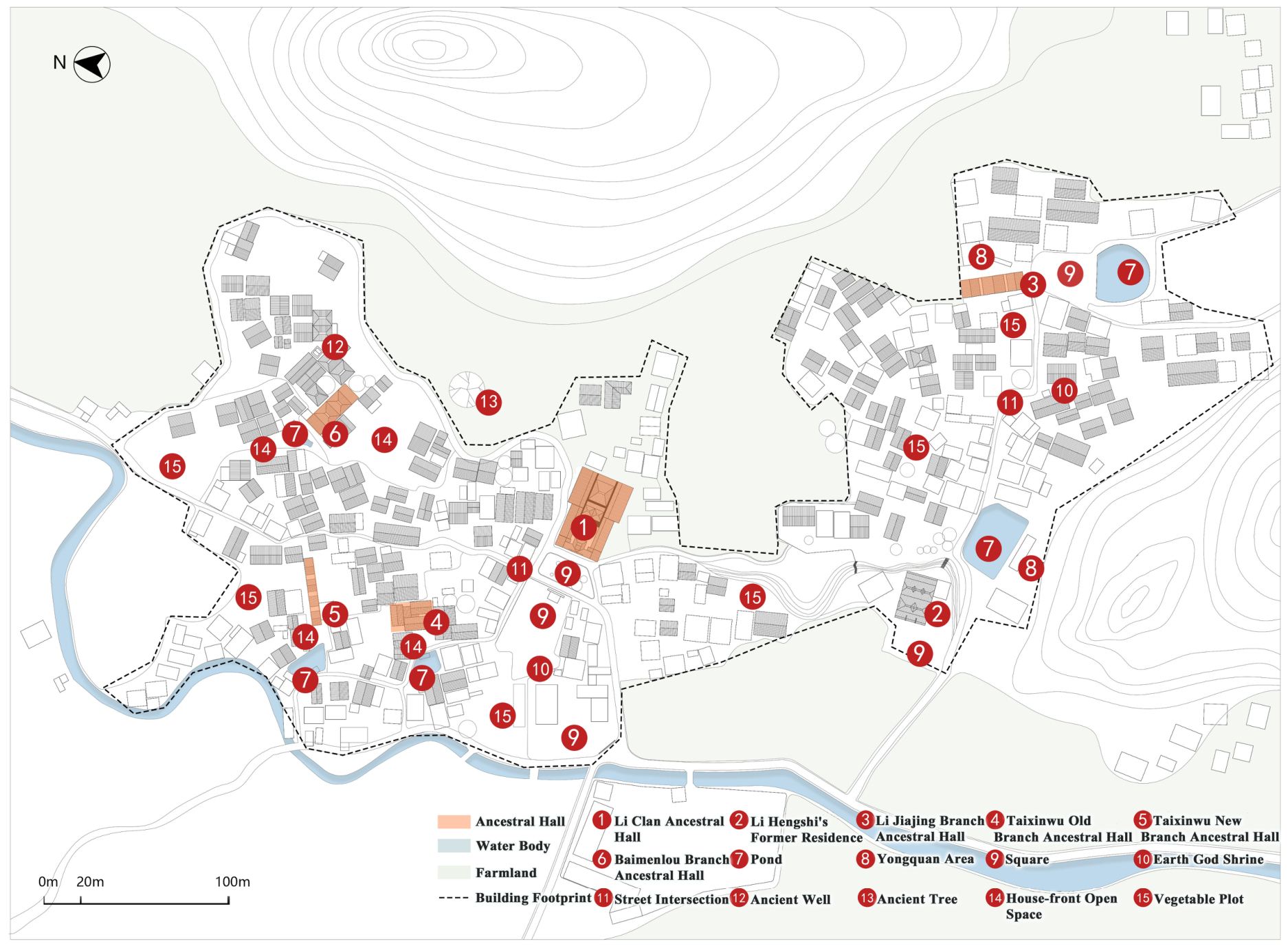
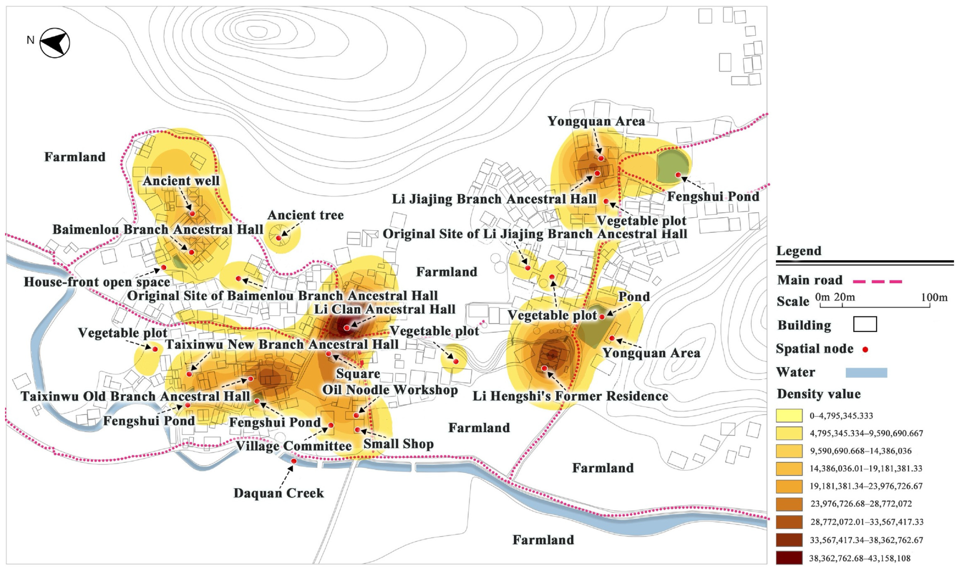
Spatial mapping identified 34 public activity spaces across Yutu Village (Figure 5). Their spatial distribution exhibits a polycentric pattern. The strongest concentration is centered on the Li Clan Ancestral Hall within the Taixinwu residential cluster, while secondary nodes are distributed around branch ancestral halls, Li Hengshi’s Former Residence, ponds, street intersections, and other historical residential clusters. Rather than functioning as isolated sites, these spaces form an overlapping public-space network in which ancestral halls, squares, streets, ponds, and house-front spaces support different combinations of historical-cultural, daily-life and production activities and ritual and folk-cultural activities.
At the typological level, cross-referencing the 58 event units with the 34 physical spaces yielded six functional typologies of event-based public space (Table 7): historical commemoration spaces, cultural heritage spaces, daily life spaces, agricultural production spaces, ceremonial spaces, and folk cultural spaces. Prominent spatial elements, especially ancestral halls, public squares, streets and alleys, ponds, and ancient trees, appear across multiple typologies, indicating that public spaces in Yutu Village often carry overlapping social, cultural, and everyday functions.

4.3. Spatial Clustering Analysis of Event-Based Public Spaces

The 241 spatial coordinate points mapped to specific events were processed using KDE and Ripley’s K-function for both the comprehensive dataset and each distinct event category.
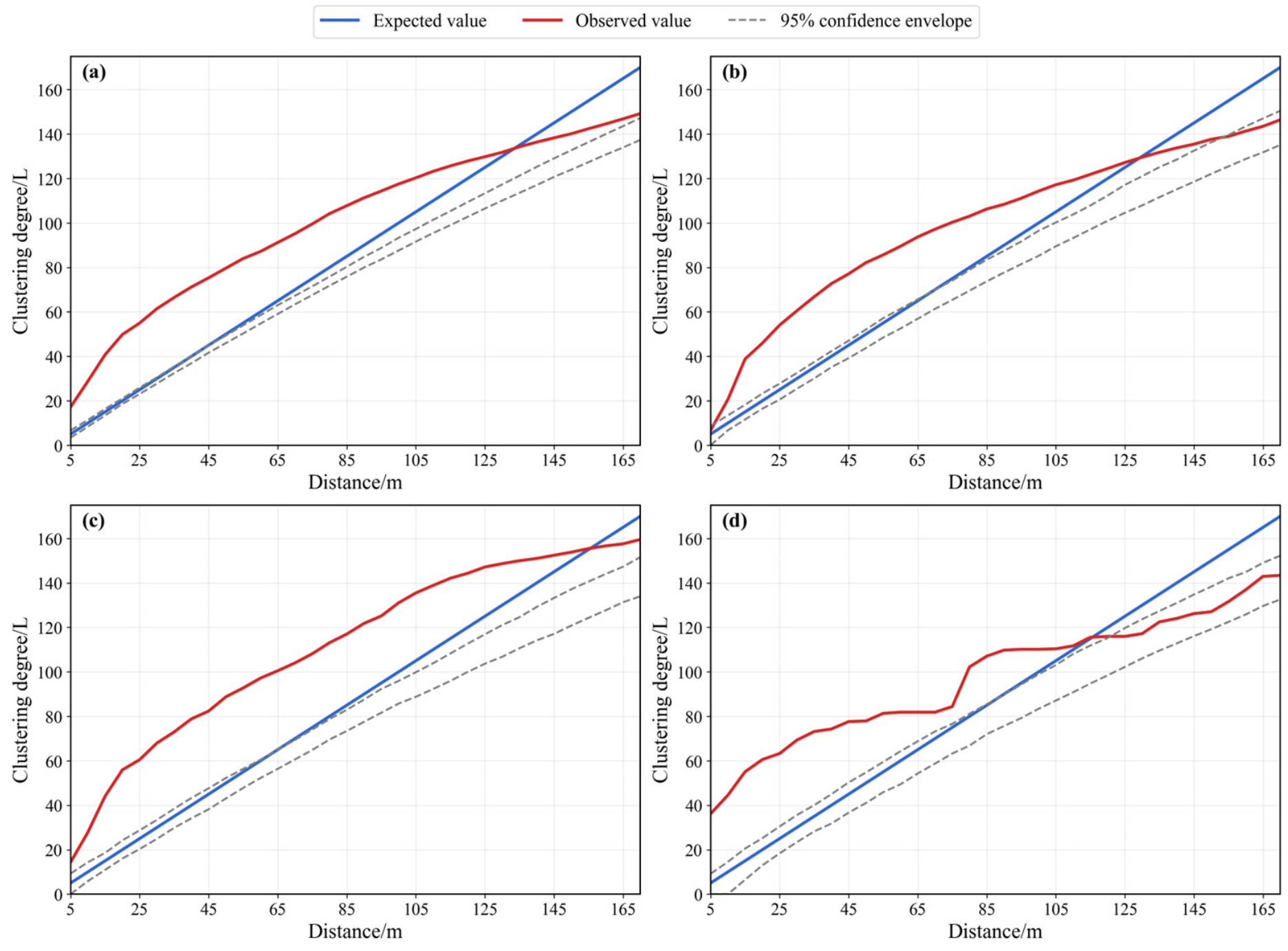
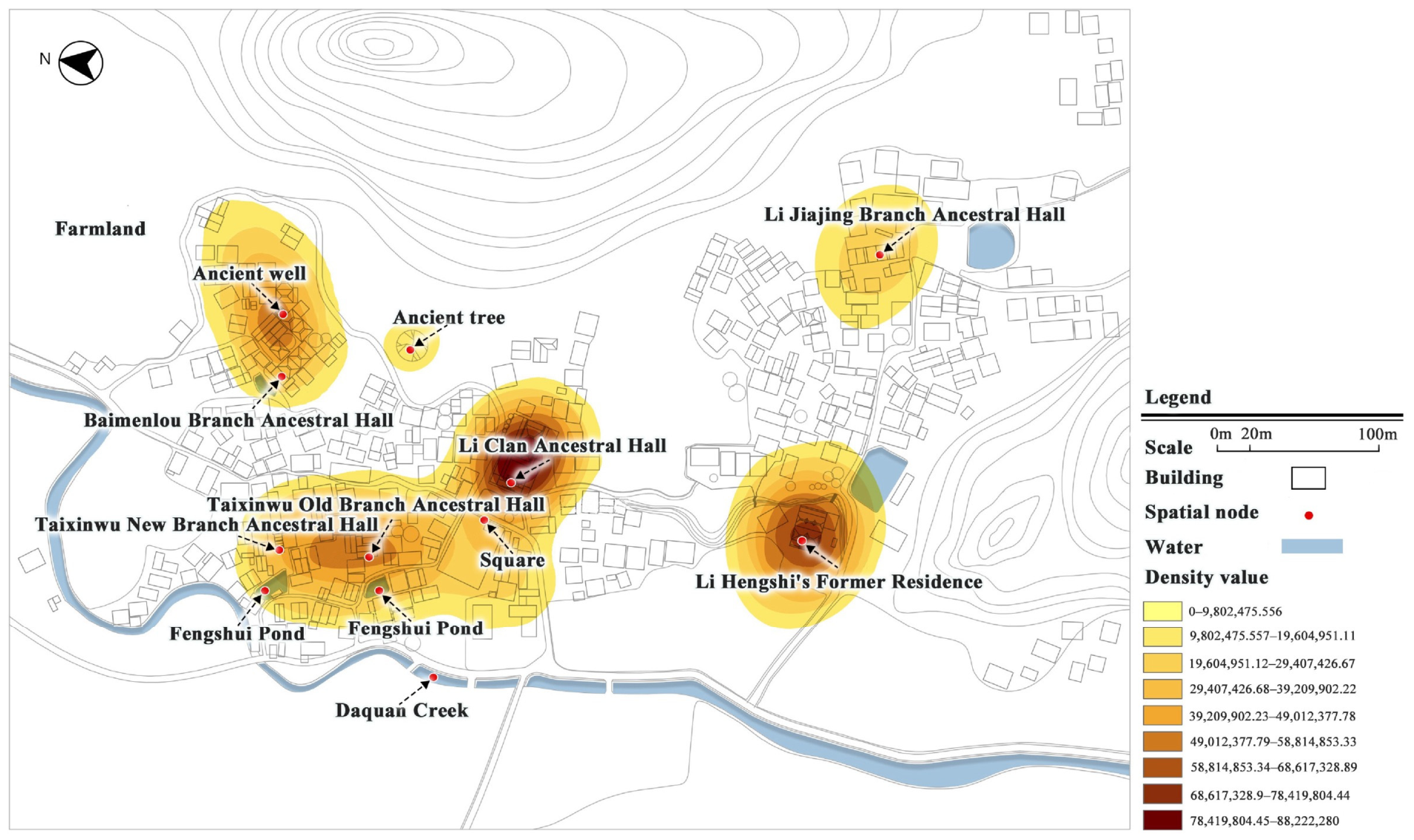
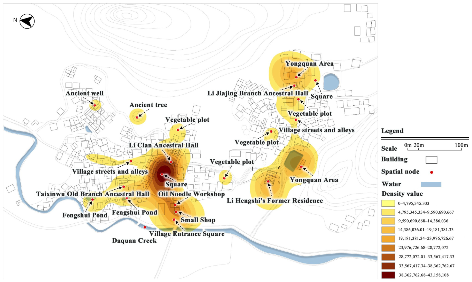
The overall KDE results (Figure 6) highlight two primary hotspot areas. The first hotspot is centered on the Li Clan Ancestral Hall within the Taixinwu cluster and extends into the surrounding residential area. The second hotspot centers on Li Hengshi’s Former Residence within the Li Jiajing cluster, functioning as a vital node for public life and cultural transmission. Ripley’s K-function analysis further validates the clustering within the overall event distribution (Figure 7a). Spatial clustering is most pronounced at short distances between 5 and 30 m, where public squares and ancestral halls accumulate multiple event types. This clustering effect gradually weakens as distance increases, although the distribution maintains a non-random structure even at broader scales.

4.3.1. Historical and Cultural Spaces

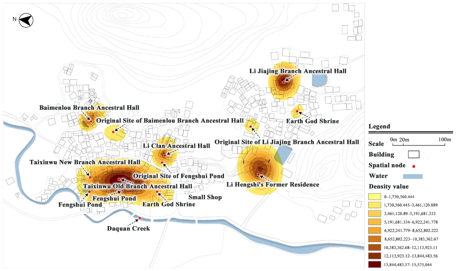
Historical and cultural activities predominantly cluster around a limited set of heritage nodes, including the Li Clan Ancestral Hall, branch ancestral halls, traditional dwelling clusters, and Li Hengshi’s Former Residence (Figure 8). Event density demonstrates lower intensity around certain branch ancestral halls, potentially reflecting weakened lineage-related use and reduced experiential connections to these structures. The K-function results corroborate this spatial pattern, indicating that historical and cultural events remain tightly concentrated around a highly selective number of preserved heritage sites (Figure 7b).

4.3.2. Daily Life and Production Spaces

Daily life and production activities are extensively distributed around public squares, ponds, streets and alleys, and vegetable plots (Figure 9). This distribution highlights the intimate integration of daily social life, movement corridors, and localized production within the settlement. Compared with historical and cultural events, daily life and production events demonstrate a significantly broader clustering range. The K-function analysis (Figure 7c) reveals sustained clustering extending up to 155 m, suggesting that these events distribute through interconnected spatial networks rather than remaining confined to isolated architectural nodes.

4.3.3. Ceremonial and Folk Cultural Spaces

Ritual and folk cultural activities are primarily anchored to ancestral halls and local Earth God shrines (Figure 10). These confined spaces operate as localized carriers of ritual practice, cultural identity, and routine blessing-seeking activities. Their spatial clustering pattern diverges markedly from the previous two categories. The K-function analysis confirms this distinction (Figure 7d): the observed K ^ d values exceed the expected values at distances below approximately 75 m, indicating significant clustering within the immediate vicinity of ceremonial nodes. However, beyond this range the observed curve converges rapidly toward the random baseline and falls within the confidence envelope by approximately 105 m. This sharp attenuation contrasts with the sustained clustering of daily life and production events (up to 155 m), indicating that ritual and folk cultural events are spatially intense but strictly confined to small-scale sacred sites rather than distributed through broader village networks.

4.4. Space–Event Structural Units

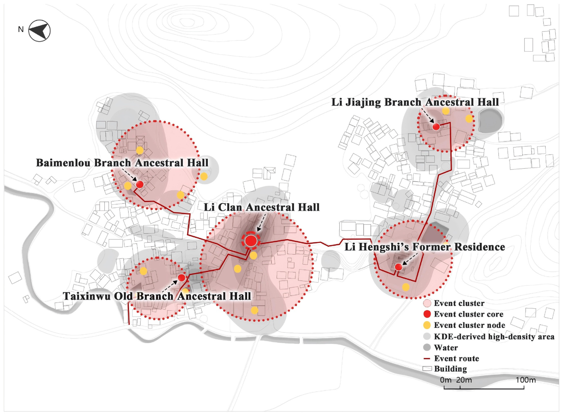
Overlaying the category-specific KDE results was used to s generate a comprehensive Space–Event structural map of Yutu Village (Figure 11). The resulting composite spatial organization can be summarized as “one core, multiple centers, four axes, and five clusters”.
Within this hierarchy, the Li Clan Ancestral Hall functions as the primary core, while Li Hengshi’s Former Residence, the branch ancestral halls, the ancient well, and ancient trees serve as secondary centers. The four axes delineate the main linear corridors connecting these public spaces, and the five clusters represent zones where multiple event spaces overlap. This composite pattern shows that event-based public-space vitality is spatially hierarchical rather than evenly dispersed. The primary core consolidates the strongest overlap among all event types; the secondary centers distribute activity intensity across branch settlements and everyday landscape nodes; the axes support pedestrian movement and daily connections; and the clusters indicate localized accumulation of communal activities.

4.5. Perception-Based Evaluation Results

4.5.1. Exploratory Factor Analysis

Exploratory factor analysis of the 23 evaluation indicators extracted six distinct factors with eigenvalues exceeding 1.0, explaining 64.537% of the cumulative variance. All factor loadings surpassed the 0.4 threshold, indicating that the indicators successfully aligned with their corresponding event–space subcategories (Table 8). Mean scores demonstrated minor variations across the factors. Historical Commemoration (Mean = 4.10) and Cultural Heritage (Mean = 4.08) achieved the highest rankings, whereas Agricultural Production (Mean = 3.82) received the lowest relative importance ranking.

4.5.2. Importance–Satisfaction Gap Analysis

Paired-sample t-tests revealed statistically significant negative gaps between perceived importance and actual satisfaction across all 23 indicators (p < 0.001 for all items; Table 9). Spatial narrative demonstrates the most substantial deficit (Gap: Δ = −1.66), ranking first in importance but twenty-first in satisfaction. The highest importance scores were assigned to spatial narrative (4.22), craft transmission (4.21), and educational dissemination (4.13). Conversely, the lowest satisfaction scores were observed in technological integration (2.47), traditional activities (2.55), and spatial narrative (2.56). Notably, the highest satisfaction scores were exclusively recorded within the ceremonial spaces category, specifically for legibility (3.34), spiritual beliefs (3.25), and ritual practices (3.13).

4.5.3. IPA Quadrant Analysis

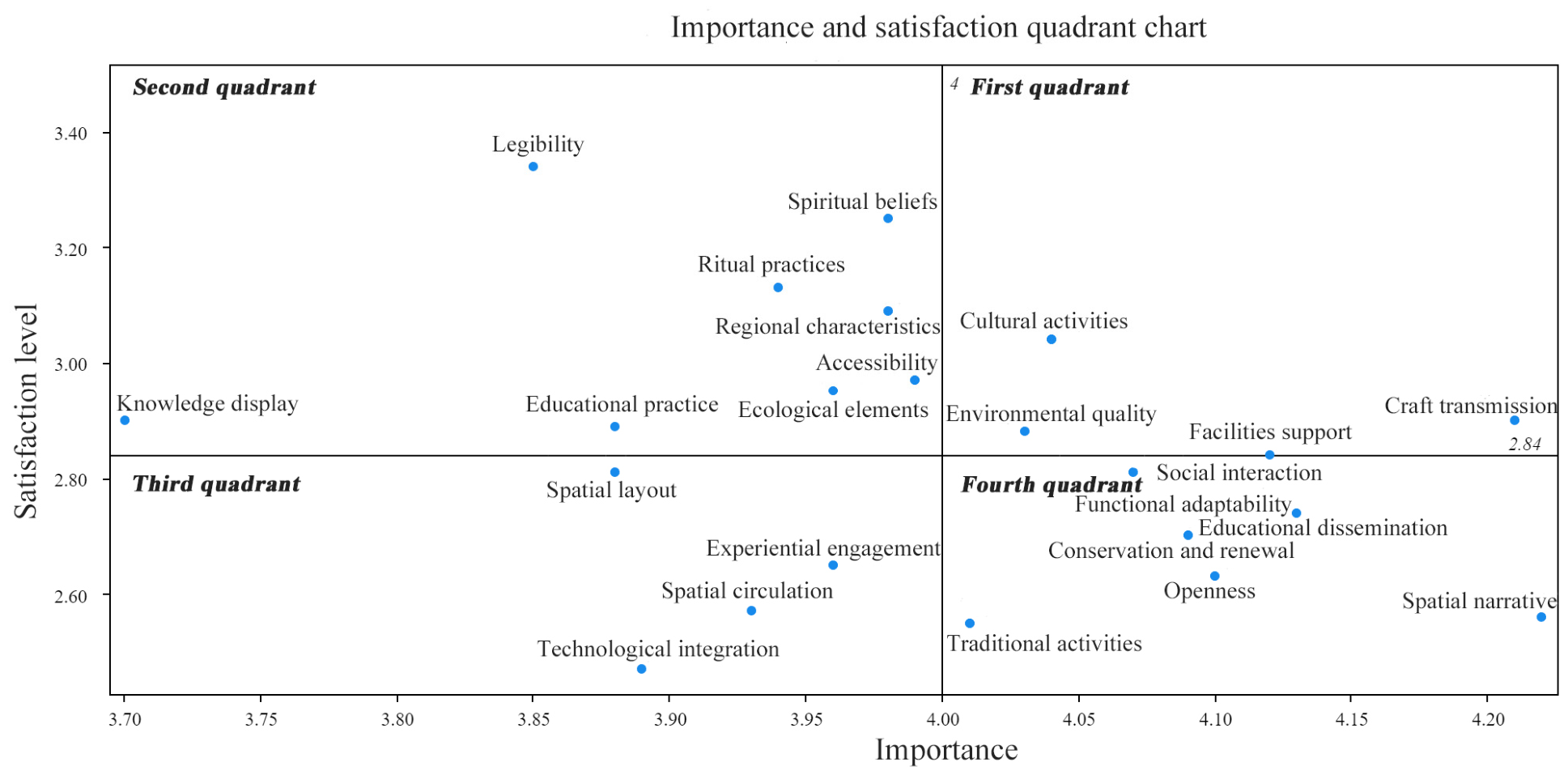
An IPA quadrant matrix was constructed using the grand means of importance and satisfaction scores as the intersecting axes (Figure 12). The 23 indicators were mapped across four quadrants to interpret priority interventions.
Quadrant I, characterizing high importance and high satisfaction, contains environmental quality, cultural activities, facilities support, and craft transmission. While these represent areas to “keep up the good work”, their satisfaction scores remain only marginally above the grand mean, indicating remaining room for incremental improvement. Quadrant II, denoting low importance and high satisfaction, encompasses legibility, spiritual beliefs, and ritual practices. Their relatively high satisfaction scores suggest a degree of cultural resilience in clan-based ritual practices. These indicators are therefore not immediate improvement priorities, although their existing cultural functions should be maintained. Quadrant III features indicators of low importance and low satisfaction, including technological integration, spatial circulation, experiential engagement, and spatial layout. These constitute lower priorities, though selective enhancements to spatial circulation could yield indirect benefits for overall village connectivity. Quadrant IV represents the most urgent improvement priorities characterized by high importance and low satisfaction. This critical quadrant contains traditional activities, openness, functional adaptability, and spatial narrative. The profound deficit in spatial narrative, combined with low satisfaction in traditional activities, points to a concentrated set of vitality deficits within the domains most deeply tied to cultural meaning and active public engagement.

5. Discussion

5.1. Spatial Clustering Patterns and Village Social Structure

The spatial analysis indicates that the distribution of event-based public spaces in Yutu Village is closely related to the village’s clan-based social structure. The composite pattern of “one core, multiple centers, four axes, and five clusters” corresponds broadly to the traditional settlement organization known locally as “one surname, three branches, and seven ancestral halls”. The Li Clan Ancestral Hall, as the highest-status communal building, functions as the primary spatial nucleus where historical and cultural, daily life and production, and ritual and folk cultural events converge. This pattern suggests that ancestral institutions continue to organize public life in traditional Chinese settlements and is consistent with studies that describe ancestral halls as multipurpose community hubs rather than isolated ceremonial structures [62,66,67].
More specifically, the observed spatial hierarchy reflects a two-tier lineage structure. The Li Clan Ancestral Hall forms the village-wide core, the surviving branch halls operate as secondary centers, and the three lineage branches correspond broadly to distinct event-clustering zones. In this sense, the public-space structure can be read as a spatial expression of lineage organization. This relationship also helps explain the uneven vitality of some branch halls noted in Section 4.3. Historical disruptions and later dangerous-building removal policies reduced the ancestral-hall system from seven halls to five surviving halls, while some renovated branch halls have lost part of their original fabric and ritual functions. These changes weakened their capacity to sustain collective memory and help account for the comparatively low event–space density around certain peripheral nodes.
These differentiated clustering scales further show that public-space vitality in Yutu Village is produced through different mechanisms rather than through a single form of spatial concentration. Historical and cultural events remain closely tied to a selective set of heritage buildings because collective memory depends on recognizable material carriers and historically meaningful sites [68,69]. By contrast, daily life and production events extend across the broadest clustering range, reaching up to 155 m, because everyday activities unfold through movement corridors, plazas, ponds, and transitional spaces between residential clusters [22,70]. Ritual and folk cultural events are more spatially confined, clustering around ancestral halls and Earth God shrines [62,63,71], because their vitality depends less on continuous circulation than on periodic gatherings at fixed sacred locations. These differences indicate that event-based public-space vitality should be understood as a combination of heritage anchoring, everyday networking, and ritual localization.

5.2. Vitality Gaps and Spatially Differentiated Planning Strategies

The IPA results indicate statistically significant negative gaps between perceived importance and satisfaction across all 23 indicators (p < 0.001 for all items), showing that residents’ expectations for public space vitality exceed their lived experience. The largest deficits identified through IPA are concentrated in culturally meaningful and activity-support dimensions, especially spatial narrative (Δ = −1.66), traditional activities, openness, and functional adaptability. These gaps suggest that the main challenge is not the absence of public spaces but the weakening connection between spatial settings, cultural memory, and contemporary everyday use, a tension also observed in traditional villages facing modernization, out-migration, and heritage conservation pressures [1,10,72,73].
Notably, ceremonial-space indicators achieved the highest satisfaction scores, including legibility (3.34), spiritual beliefs (3.25), and ritual practices (3.13). This suggests that clan-based ritual practices still maintain a degree of cultural resilience [46,62,63]. Through continued ceremonial use, ancestral halls and Earth God shrines preserve a legible connection between physical space and cultural meaning, indicating that vitality maintenance depends not only on physical renovation but also on recurring events that continue to activate cultural meanings in place.
Cross-referencing the event-clustering patterns with the IPA quadrant results leads to three differentiated strategy directions (Table 10): narrative restoration for historical-cultural spaces, connectivity and texture mending for daily-life and production spaces, and protective maintenance for ceremonial and folk cultural spaces. These strategies extend existing arguments on narrative-oriented heritage renewal and participatory public-space governance [47,68,74] by linking intervention priorities to both event clustering and residents’ perception gaps. They should be supported by a cross-space participation mechanism in which residents lead the identification of everyday needs and local narratives, while local government, social organizations, and universities provide technical support, heritage programming, small-scale funding, and digital dissemination [10,47,56].

5.3. Comparison with Existing Studies and Research Contribution

To clarify the contribution of this study, Table 11 positions it against representative domestic and international studies on rural public space vitality. Existing research can be broadly grouped into three approaches. The first approach uses interviews, memory mapping, or emotional maps to reveal how collective memory and place attachment are embedded in rural public spaces. For example, Wang et al. examined memory and emotional mapping in migrant villages, showing that residents’ remembered places can be spatially organized [15]. However, such studies usually remain qualitative or descriptive and rarely test whether the observed spatial patterns significantly depart from randomness.
The second approach focuses on spatial morphology, accessibility, or sensing-based measurement. Studies using space syntax, Wi-Fi sensing, or other spatial data have improved the objective measurement of public-space use and spatial structure. These methods are valuable for identifying movement patterns and spatial intensity, but they often treat activity as an aggregate phenomenon and pay less attention to the cultural meanings, event types, and resident perceptions attached to different spaces. The third approach evaluates rural vitality through perception surveys or indicator systems. Studies by Chen et al. [16], Mróz and Zwęglińska-Gałecka [36], and Roumiani et al. [38] have contributed useful evaluation frameworks, but they usually emphasize overall vitality, satisfaction, or quality-of-life indicators rather than linking perception gaps to statistically tested intra-village spatial clustering.
Compared with these approaches, this study makes three related contributions. Theoretically, it treats events as an independent analytical unit rather than as a background attribute of public space, showing that historical-cultural, daily-life and production, and ritual-folk events generate different spatial clustering scales. Methodologically, it combines KDE and Ripley’s K-function with IPA, linking objective spatial patterns with residents’ subjective evaluations within the same village-scale framework. Practically, this integration allows planning strategies to be derived from the intersection of event clustering and perception gaps: narrative restoration for historical-cultural spaces, connectivity and texture mending for daily-life and production spaces, and protective maintenance for ceremonial and folk cultural spaces. In this sense, the Space–Event framework provides a more fine-grained and culturally responsive approach to traditional village public-space renewal than studies relying on spatial measurement or perception evaluation alone.

5.4. Limitations and Future Directions

Several limitations should be acknowledged. First, the study is based on a single clan-based village, so the specific clustering thresholds and renewal strategies identified here may not be directly transferable to settlements with different social structures, ethnic compositions, or spatial morphologies. Second, although the 112 valid questionnaires are adequate for the exploratory factor analysis and IPA adopted in this study, the sample size limits more fine-grained demographic subgroup analysis and confirmatory modeling. Third, the participatory mapping was conducted in October 2024 during daytime fieldwork, which may underrepresent seasonal, nighttime, or festival-specific events. Finally, although participant-marked points are valuable for capturing perceived spatial salience, manual location marking inevitably introduces some subjectivity in coordinate assignment.
Future research could extend the Space–Event framework to multiple village typologies for comparative testing, enlarge the sample to support subgroup and confirmatory analyses, and conduct longitudinal mapping across different seasons, festival periods, and times of day. Future studies could also combine participant-marked points with additional spatial records, such as GPS-assisted walking traces or repeated field observations [76], to improve the temporal and spatial resolution of event–space analysis.

6. Conclusions

This study developed and applied a Space–Event analytical framework to examine public space vitality in Yutu Village, a clan-based traditional settlement in southeastern Hubei, China. By integrating GIS-based spatial statistics with IPA, the study found that event-based public spaces form a hierarchical structure of one core, multiple centers, four axes, and five clusters, broadly corresponding to the village’s lineage-based spatial organization. Different event types showed distinct clustering patterns: historical-cultural events were anchored around heritage buildings, ritual and folk cultural events remained concentrated around small-scale ceremonial nodes, and daily life and production events extended along everyday corridors up to 155 m. The perception-based evaluation further revealed negative importance-satisfaction gaps across all indicators, with the largest deficit in spatial narrative (Δ = −1.66) and the strongest relative resilience in ceremonial spaces.
The study makes three main contributions. Theoretically, it treats events as an independent analytical unit and demonstrates how event types help explain differentiated spatial clustering in traditional village public spaces. Methodologically, it combines KDE, Ripley’s K-function, and IPA to link objective spatial patterns with residents’ subjective evaluations. Practically, it derives differentiated renewal strategies by cross-referencing clustering types with perception gaps, including narrative restoration for historical-cultural spaces, connectivity and texture mending for daily-life and production spaces, and protective maintenance for ceremonial and folk cultural spaces. These findings provide a culturally responsive and evidence-based basis for targeted public-space renewal in traditional villages.

Author Contributions

Conceptualization, R.C.; methodology, R.C., C.T. and J.L.; software, T.L. and C.T.; validation, R.C. and T.L.; formal analysis, R.C. and C.T.; investigation, T.L. and C.T.; resources, R.C. and T.L.; data curation, C.T.; writing—original draft preparation, R.C. and C.T.; writing—review and editing, J.L.; visualization, C.T. and J.L.; supervision, R.C.; project administration, R.C.; funding acquisition, R.C. and J.L. All authors have read and agreed to the published version of the manuscript.

Funding

This research was supported by grants from the National Natural Science Foundation of China (NSFC) under Grant Nos. 52478056 and 42401508, by the Program of China Scholarship Council under Grant No. 202506410189, and by the China Postdoctoral Science Foundation under Grant No. 2024M763064.

Data Availability Statement

The original data presented in the study are available in Figshare at https://figshare.com/s/415133c9297b2c19908e (accessed on 3 June 2026).

Conflicts of Interest

The authors declare no conflicts of interest.

Appendix A

Table A1. List of identified events in Yutu Village.
Event TypeNoEvent DescriptionEvent SpacePeriod
Collective Memory Events1Ancestor Li Tianqi migrated to Muzhaizui, Xingguo Prefecture, and settled there/Early Ming Dynasty
2Li Tailu, grandson of Li Tianqi, relocated from Muzhaizui to this siteTa Xinwu areaLate Ming–Early Qing
3Gradual improvement of village layout, population growth, and flourishing lineage/Qing Dynasty
4Li Hengshi “recovered Ili without military force”/6th year of Guangxu (Qing)
5Li Hengshi was awarded the rank of Senior Second Official and appointed Judicial Commissioner of Xinjiang/Qing Dynasty
6Twenty-four imperial edicts were granted to the Li clan by successive emperors/Ming and Qing Dynasties
7Li Hengshi returned in honor and funded the construction of the Li Clan Ancestral HallLi Clan Ancestral Hall26th year of Guangxu
8Officially commissioned residence of Li HengshiFormer Residence of Li Hengshi31st year of Guangxu
9Li Hengshi established a charitable schoolLi Clan Ancestral HallQing Dynasty
10Both sides of the ancestral hall were converted into a village primary schoolLi Clan Ancestral Hall1950
11The ancestral hall was restored and ritual activities resumedLi Clan Ancestral HallPost-Reform era
12Drinking and domestic water useQingshi Double WellsBuilt in Ming Dynasty
13Newly married brides circumambulated the ancestral house before enteringBaimenlou Ancestral HouseMing–Qing
14Villagers worship ancestors during festivalsLi Clan Ancestral HallFrom Qing to present
15Opera performances during festivalsLi Clan Ancestral HallAnnual festivals
16Elderly gathering and singing on Double Ninth FestivalLi Clan Ancestral HallAnnual
17Land boat rowing and dragon dancing on Lunar New Year’s DayVillage streetsAnnual
18“Welcoming Taigong” ritual on Taigong’s birthdayVillage streets/
19“New Rice Festival” offering new rice to ancestors/Lunar June (Mao or Chen day)
20“Water-Sending Festival” ritual/Seasonal
21“Thousand-Day Ritual” for newborns/
22Guan Gong Festival praying for harvest and peace/Lunar May 13
23“Welcoming Ancestors” ritual for deceased relatives/Mid-July (Lunar)
24Lantern Festival vegetable-touching customVillage vegetable gardenAnnual
25Legend: Li Hengshi Reclaims Ili with Sharp Words/Qing
26Legend: Ji Gong Builds the Hundred Buddha TempleHundred Buddha Temple/
27Legend: Qin Shi Huang Creates the Eighteen BendsShibazhe Village/
28Incense burning during She Day and Zhonghe FestivalAlley land deity shrine2nd and 16th monthly
29Worship of Grain DeityKitchen walls, farmlandLunar April 18
30Ancestral worshipTomb of Li HengshiFrom Qing to present
31Deceased clan members’ spirits remain in ancestral house for 35 daysTa Xinwu ancestral house/
32Tomb-sweeping and ancestral ritesBack mountain of Yutu VillageQingming Festival
33Leisure activities (cards, billiards)Former Residence of Li Hengshi/
34Daily gatherings and chattingAncestral Hall plaza, branch hall plazas/
35Washing vegetables and clothes at springsVarious springs/
36Watching films at the threshing groundThreshing ground/
37Purchasing daily necessitiesVillage grocery shop/
38Wedding and funeral ceremoniesAncestral halls/
39Children playing; communal dining and chattingGrocery shop, plazas/
40Oil-noodle production after Li clan settled in YutuOil-noodle workshopPost-Qing
41Women’s Day gathering and village cleaning/Annual March 8
42Demolition of old public housesVillage public buildingsModern era
43Wasteland converted into pondLi Jiajing Pond/
44Casual encounters and conversationsStreet corners, house-front spaces/
45Afternoon and evening exercisePond-side fitness area/
46Reading news and noticesVillage entrance bulletin board/
47Villagers resting under ancient camphor treeBaimenlou ancient tree/
48Drying grain, camellia seeds, cabbagePlaza and front yard spaces/
49Early morning farming activitiesVegetable gardens, farmland/
Individual Biographical Events50Taught for 50 years; now makes brooms for livelihoodPrimary school in ancestral hall/
51Oil-noodle productionResidential house/
52Handmade tray productionResidential house/
53Retired teacher; recounts village historyHistoric building cluster/
54Rice cultivationFarmland, plaza/
55Village committee director; organizes activitiesVillage committee office/
5695-year-old elder residing in historic buildingsHistoric building cluster/
57Municipal-level inheritors of Yutu oil-noodle craftVillage oil-noodle cooperative/
58Baimenlou group leader; manages ancestral hall and organizes major eventsLi Clan Ancestral Hall/
Note: “/” indicates that the detailed space or time cannot be accurately identified.

References

  1. Xue, L.; Pan, X.; Wang, X.; Zhou, H. Traditional Chinese Villages: Beautiful Nostalgia; Springer Nature: Singapore, 2021. [Google Scholar]
  2. Convention for the Safeguarding of the Intangible Cultural Heritage—Legal Affairs. Available online: https://www.unesco.org/en/legal-affairs/convention-safeguarding-intangible-cultural-heritage (accessed on 29 April 2026).
  3. Manzo, L.; Devine-Wright, P. (Eds.) Place Attachment: Advances in Theory, Methods and Applications, 2nd ed.; Routledge: London, UK, 2020. [Google Scholar]
  4. Qian, J. Geographies of Public Space: Variegated Publicness, Variegated Epistemologies. Prog. Hum. Geogr. 2020, 44, 77–98. [Google Scholar] [CrossRef]
  5. Aquilino, L.; Harris, J.; Wise, N. A Sense of Rurality: Events, Placemaking and Community Participation in a Small Welsh Town. J. Rural Stud. 2021, 83, 138–145. [Google Scholar] [CrossRef]
  6. Ray, C. The EU LEADER programme: Rural development laboratory. Sociol. Rural. 2000, 40, 163–171. [Google Scholar] [CrossRef]
  7. Shucksmith, M. Endogenous development, social capital and social inclusion: Perspectives from LEADER in the UK. Sociol. Rural. 2000, 40, 208–218. [Google Scholar] [CrossRef]
  8. Buller, H. Re-Creating Rural Territories: LEADER in France: Rural Development in Europe: The EU Leader Programme Reconsidered. Sociol. Rural. 2000, 40, 190–199. [Google Scholar] [CrossRef]
  9. Henkel, G. Das Dorf. Landleben in Deutschland—Gestern und Heute, 4th ed.; Bundeszentrale für Politische Bildung: Bonn, Germany, 2020. [Google Scholar]
  10. Chigbu, U.E. Village Renewal as an Instrument of Rural Development: Evidence from Weyarn, Germany. Community Dev. 2012, 43, 209–224. [Google Scholar] [CrossRef]
  11. Haraguchi, N. The One-Village-One-Product (OVOP) Movement: What It Is, How It Has Been Replicated, and Recommendations for a UNIDO OVOP-Type Project; UNIDO Research and Statistics Branch Working Paper 03/2008; UNIDO: Vienna, Austria, 2008. [Google Scholar]
  12. Mukai, K.; Fujikura, R. One Village One Product: Evaluations and Lessons Learnt from OVOP Aid Projects. Dev. Pract. 2015, 25, 389–400. [Google Scholar] [CrossRef]
  13. Central Committee of the Communist Party of China; State Council of the People’s Republic of China. No. 1 Central Document of 2026: Opinions on Anchoring Agricultural and Rural Modernization and Advancing Comprehensive Rural Revitalization. 2026. Available online: https://www.gov.cn/gongbao/2026/issue_12566/202602/content_7057938.html (accessed on 23 February 2026).
  14. Zhang, J.; Shen, M.; Zhao, C. Rural revival: Chinese rural transformation under productivism and post-productivism. Urban Plan. Int. 2014, 29, 1–7. [Google Scholar]
  15. Wang, M.; Han, P.; Li, X.; Bao, X.; Huang, J. Continuation and Evolution of Collective Memory Manifested in Rural Public Space: Revealed by Semi-Structured Interviews and Emotional Maps in Three Migrant Villages in Chaihu Town. Habitat Int. 2024, 154, 103213. [Google Scholar] [CrossRef]
  16. Chen, Q.; Zhang, W.; Shou, J.; Zhang, M. Vitalizing Public Space in Traditional Village Based on Scene Theory: Evidence from Shen’ao Village in Zhejiang, China. Land 2025, 15, 67. [Google Scholar] [CrossRef]
  17. Ding, W.; Atayan, B.P. Optimization Algorithm for Rural New Public Cultural Space Governance Structure Based on Complex Network Analysis. In Artificial Intelligence for Future Society; Palade, V., Favorskaya, M., Patnaik, S., Simic, M., Belciug, S., Eds.; Springer Nature: Cham, Switzerland, 2024; pp. 16–26. [Google Scholar] [CrossRef]
  18. Sheng, L.; Ma, J. Village Clans and Rural Households’ Willingness to Participate in Domestic Waste Governance: Evidence from China. J. Clean. Prod. 2023, 425, 138951. [Google Scholar] [CrossRef]
  19. Etuk, L.E.; Acock, A. Toward a Rural Community Vitality Measurement Practice. Community Dev. 2017, 48, 141–153. [Google Scholar] [CrossRef]
  20. Zhang, Q.; Yao, X.; Xu, J.; Chen, Z.; Yang, D.; Yang, P. Cultural Vitality as a Catalyst for Sustainable Rural Development: Strategies for Enhancing Public Spaces in Fujian Province, China. Int. Rev. Spat. Plan. Sustain. Dev. 2025, 13, 63–82. [Google Scholar] [CrossRef] [PubMed]
  21. Liu, S.; Ge, J.; Bai, M.; Yao, M.; He, L.; Chen, M. Toward Classification-Based Sustainable Revitalization: Assessing the Vitality of Traditional Villages. Land Use Policy 2022, 116, 106060. [Google Scholar] [CrossRef]
  22. Gehl, J. Cities for People; Island Press: Washington, DC, USA, 2010. [Google Scholar]
  23. Jacobs, J. The Death and Life of Great American Cities; Random House: New York, NY, USA, 1961. [Google Scholar]
  24. Sennett, R. Building and Dwelling: Ethics for the City; Farrar, Straus and Giroux: New York, NY, USA, 2018. [Google Scholar]
  25. Lynch, K. Good City Form; MIT Press: Cambridge, MA, USA, 1984. [Google Scholar]
  26. Whyte, W.H. The Social Life of Small Urban Spaces; Project for Public Spaces: New York, NY, USA, 2001. [Google Scholar]
  27. Bentley, I. Responsive Environments: A Manual for Designers; Butterworth Architecture: Oxford, UK, 1995. [Google Scholar]
  28. Kang, C.; Fan, D.; Jiao, H. Validating Activity, Time, and Space Diversity as Essential Components of Urban Vitality. Environ. Plan. B Urban Anal. City Sci. 2020, 48, 1180–1197. [Google Scholar] [CrossRef]
  29. Yue, Y.; Zhuang, Y.; Yeh, A.G.O.; Xie, J.Y.; Ma, C.L.; Li, Q.Q. Measurements of POI-Based Mixed Use and Their Relationships with Neighbourhood Vibrancy. Int. J. Geogr. Inf. Sci. 2017, 31, 658–675. [Google Scholar] [CrossRef]
  30. Huang, J.; Hu, X.; Wang, J.; Lu, A. How Diversity and Accessibility Affect Street Vitality in Historic Districts? Land 2023, 12, 219. [Google Scholar] [CrossRef]
  31. Jin, A.; Ge, Y.; Zhang, S. Spatial Characteristics of Multidimensional Urban Vitality and Its Impact Mechanisms by the Built Environment. Land 2024, 13, 991. [Google Scholar] [CrossRef]
  32. Gómez-Varo, I.; Delclòs-Alió, X.; Miralles-Guasch, C. Jane Jacobs reloaded: A contemporary operationalization of urban vitality in a district in Barcelona. Cities 2022, 123, 103565. [Google Scholar] [CrossRef]
  33. Chen, H.; Ge, J.; He, W. Quantifying urban vitality in Guangzhou through multi-source data: A comprehensive analysis of land use change, streetscape elements, POI distribution, and smartphone-GPS data. Land 2025, 14, 1309. [Google Scholar] [CrossRef]
  34. Xia, C.; Yeh, A.G.-O.; Zhang, A. Analyzing spatial relationships between urban land use intensity and urban vitality at street block level: A case study of five Chinese megacities. Landsc. Urban Plan. 2020, 193, 103669. [Google Scholar] [CrossRef]
  35. Terluin, I.J. Differences in economic development in rural regions of advanced countries: An overview and critical analysis of theories. J. Rural Stud. 2003, 19, 327–344. [Google Scholar] [CrossRef]
  36. Mróz, A.; Zwęglińska-Gałecka, D. Sustaining Rural Vitality: Lessons from Podlaskie, Poland. Eur. Plan. Stud. 2026, 34, 437–460. [Google Scholar] [CrossRef]
  37. Stavělová, D. Why Do We Have So Many Carnivals in Town Today? An Event Between Ritual, Politics and Festival. Slov. Národop. 2023, 71, 342–364. [Google Scholar] [CrossRef]
  38. Roumiani, A.; Ebrahimi Salari, T.; Mahmoodi, H.; Shateri, M. The Effect of Public Space Indicators on the Rural District’s Life Quality in Kuhdasht County, Iran. AUC Geogr. 2021, 56, 205–219. [Google Scholar] [CrossRef]
  39. Le, D.P. A Framing of Vietnamese ‘Toad Markets’ as Intermediary Spaces. In Sustainable Resilient Built Environments; Nandineni, R.D., Ang, S., Mohd Nawawi, N.B., Eds.; Springer Nature: Singapore, 2024; pp. 1043–1053. [Google Scholar]
  40. Pan, C.; Feng, X.; Zhao, M. A novel framework for rural vitality evaluation and revitalization by classification: A case of China. Habitat Int. 2025, 159, 103361. [Google Scholar] [CrossRef]
  41. Luo, J. Research on vitality measurement of village public space based on big data and multidimensional module. IOP Conf. Ser. Earth Environ. Sci. 2020, 558, 042003. [Google Scholar] [CrossRef]
  42. Jiang, Y.; Duan, J.; Zhang, Y. The spontaneous spatial restructuring of traditional village based on an analysis of social relationship: A case in Fuling, Fujian, China. Habitat Int. 2025, 157, 103309. [Google Scholar] [CrossRef]
  43. Liu, J.; Huang, Z.; Wu, X.; Hou, Q. Optimization of Urban Village Public Space Vitality Based on Complex Network. Sci. Rep. 2025, 15, 15392. [Google Scholar] [CrossRef] [PubMed]
  44. Chen, Y.; Xiong, Y.; Xi, C.; Meng, S.; Liu, C.; Zhang, Y. Analysis of Public Space Characteristics in Traditional Villages Along the Western Beijing Cultural Belt and Their Behavioral Adaptation to Residents: A Multi-Scale Perspective Study. Land 2025, 14, 1982. [Google Scholar] [CrossRef]
  45. Zhang, Y.; Chen, Z.; Chen, Z. Temporal and Spatial Characteristics and Influencing Factors of Public Space Vitality in Historical Blocks—Taking Songcheng First Road in Zhaoqing as an Example. In Proceedings of the 7th International Conference on Social Science and Higher Education (ICSSHE 2021); Atlantis Press: Dordrecht, The Netherlands, 2021; pp. 525–532. [Google Scholar] [CrossRef]
  46. Wang, H.; Xie, B.; Zeng, Y.; Liu, A.; Liu, B.; Qin, L. Intergenerational Transmission of Collective Memory in Public Spaces: A Case Study of Menghe, a Historic and Cultural Town. Sustainability 2025, 17, 8596. [Google Scholar] [CrossRef]
  47. Li, P.; Zhang, W. Intervention and Co-Creation: Art-Led Transformation of Spatial Practices and Cultural Values in Rural Public Spaces. Land 2025, 14, 1353. [Google Scholar] [CrossRef]
  48. Xu, Q.; Wang, J. Recognition of values of traditional villages in Southwest China for sustainable development: A case study of Liufang Village. Sustainability 2021, 13, 7569. [Google Scholar] [CrossRef]
  49. Zheng, J.; He, J.; Tang, H. The vitality of public space and the effects of environmental factors in Chinese suburban rural communities based on tourists and residents. Int. J. Environ. Res. Public Health 2023, 20, 263. [Google Scholar] [CrossRef]
  50. Song, J.; Zhu, Y.; Chu, X.; Yang, X. Research on the vitality of public spaces in tourist villages through social network analysis: A case study of Mochou Village in Hubei, China. Land 2024, 13, 359. [Google Scholar] [CrossRef]
  51. Xiao, J.; Qian, Y.; Chen, S.; Xu, Y.; Li, B. Research on publicness evaluation and behavioral characteristics in traditional village–A case study of Chongqing Hewan Village. Buildings 2024, 14, 1759. [Google Scholar] [CrossRef]
  52. Lefebvre, H. The Production of Space; Blackwell: Oxford, UK, 1991. [Google Scholar]
  53. Rossi, A. The Architecture of the City; The MIT Press: Cambridge, MA, USA, 1982. [Google Scholar]
  54. Bernard Tschumi Architects. Architecture and Disjunction; The MIT Press: Cambridge, MA, USA, 1996. [Google Scholar]
  55. Freestone, R.; Liu, E. Place and Placelessness Revisited; Routledge: New York, NY, USA, 2016. [Google Scholar]
  56. Latham, A.; Layton, J. Social Infrastructure and the Public Life of Cities: Studying Urban Sociality and Public Spaces. Geogr. Compass 2019, 13, e12444. [Google Scholar] [CrossRef]
  57. Miśkowiec, M. The Role of an Urban Festival in Public Space: Case Study of the Light Move Festival in Łódź. Acta Univ. Lodz. Folia Geogr. Socio-Acon. 2017, 29, 107–119. [Google Scholar] [CrossRef]
  58. Simpson, P. Street Performance and the City Public Space, Sociality, and Intervening in the Everyday. Space Cult. 2011, 14, 415–430. [Google Scholar] [CrossRef]
  59. Liu, M.; Li, X.; Ren, Q. Rural Festivals and Rural Cultural Spaces Creation: A Case Study of the “Yim Tin Tsai Arts Festival”. Int. J. Arts Humanit. Stud. 2023, 3, 10–17. [Google Scholar] [CrossRef]
  60. Alzahrani, M.; AlGhamdi, F. Social Media Sentiment Analysis for Sustainable Rural Event Planning: A Case Study of Agricultural Festivals in Al-Baha, Saudi Arabia. Sustainability 2025, 17, 3864. [Google Scholar] [CrossRef]
  61. Quinn, B.; Wilks, L. Festival Heterotopias: Spatial and Temporal Transformations in Two Small-Scale Settlements. J. Rural Stud. 2017, 53, 35–44. [Google Scholar] [CrossRef]
  62. Weng, W.; Xie, F.; Zhu, L. Research on Inheritance of Folk Belief Culture and Reconstruction of Rural Public Space. In Proceedings of the 3rd International Conference on Arts, Design and Contemporary Education (ICADCE 2017); Atlantis Press: Dordrecht, The Netherlands, 2017; pp. 332–335. [Google Scholar]
  63. Wu, M.Y.; Tong, Y.; Li, Q.; Wall, G.; Wu, X. Interaction Rituals and Social Relationships in a Rural Tourism Destination. J. Travel Res. 2023, 62, 1480–1496. [Google Scholar] [CrossRef]
  64. Getz, D.; Page, S.J. Event Studies: Theory, Research and Policy for Planned Events, 3rd ed.; Routledge: Abingdon, UK, 2016. [Google Scholar]
  65. Martilla, J.A.; James, J.C. Importance-Performance Analysis. J. Mark. 1977, 41, 77–79. [Google Scholar] [CrossRef]
  66. Freedman, M. Lineage Organization in Southeastern China; Routledge: London, UK, 2020. [Google Scholar]
  67. Faure, D. Emperor and Ancestor: State and Lineage in South China; Stanford University Press: Stanford, CA, USA, 2007. [Google Scholar]
  68. Nora, P. Between Memory and History: Les Lieux de Mémoire. Representations 1989, 26, 7–24. [Google Scholar] [CrossRef]
  69. Halbwachs, M. On Collective Memory; Coser, L.A., Translator; University of Chicago Press: Chicago, IL, USA, 1992. [Google Scholar]
  70. Hillier, B.; Hanson, J. The Social Logic of Space; Cambridge University Press: Cambridge, UK, 1984. [Google Scholar]
  71. Tan, D. Persistence of Everyday Sacred Landscapes: Shrines, Village Temples, and Hillside Cemetery in Shenzhen. Space Cult. 2025; OnlineFirst. [CrossRef]
  72. Central Committee of the Communist Party of China; State Council of the People’s Republic of China. Rural Comprehensive Revitalization Plan (2024–2027). 2025. Available online: https://www.gov.cn/gongbao/2025/issue_11846/202502/content_7002798.html (accessed on 23 February 2026).
  73. Liu, Y.; Liu, Y.; Chen, Y.; Long, H. The process and driving forces of rural hollowing in China under rapid urbanization. J. Geogr. Sci. 2010, 20, 876–888. [Google Scholar] [CrossRef]
  74. Li, B.; Yang, F.; Long, X.; Liu, X.; Cheng, B.; Dou, Y. The organic renewal of traditional villages from the perspective of logical space restoration and physical space adaptation: A case study of Laoche Village, China. Habitat Int. 2024, 144, 102988. [Google Scholar] [CrossRef]
  75. Zhao, Y.; Luo, Z.; Huang, K. Characterization of public space forms in traditional Chinese villages based on spatial syntax: Zhangli village as an example. J. Asian Archit. Build. Eng. 2025, 24, 3030–3051. [Google Scholar] [CrossRef]
  76. Liu, S.; Zhu, Z.; Gao, Y.; Wang, S. Assessing the dynamic vitality of public spaces in tourism-oriented traditional villages: A collaborative active perception method. Herit. Sci. 2024, 12, 346. [Google Scholar] [CrossRef]
Figure 1. Theoretical framework of Space–Event coupling and public space vitality in traditional villages.
Land 15 01223 g001
Figure 2. Mixed methods workflow for operationalizing the Space–Event framework.
Land 15 01223 g002
Figure 3. Location map of Yutu Village within Futu Town.
Land 15 01223 g003
Figure 4. Base aerial photograph used for participatory mapping, showing the 241 event–space points marked by residents (numbers 1–30 denote anonymous participant codes).
Land 15 01223 g004
Figure 5. Spatial distribution of 34 public activity spaces in Yutu Village.
Land 15 01223 g005
Figure 6. Kernel density map of all 241 event–space points in Yutu Village.
Land 15 01223 g006
Figure 7. Ripley’s K-function curves for the overall dataset and three event categories in Yutu Village: (a) overall event–space points; (b) historical and cultural events; (c) daily life and production events; and (d) ritual and folk cultural events.
Land 15 01223 g007
Figure 8. KDE map for historical and cultural events.
Land 15 01223 g008
Figure 9. KDE map for daily life and production events.
Land 15 01223 g009
Figure 10. KDE map for ritual and folk cultural events.
Land 15 01223 g010
Figure 11. Space–Event structural unit map of Yutu Village showing one core, multiple centers, four axes, and five clusters.
Land 15 01223 g011
Figure 12. IPA quadrant matrix of villagers’ evaluations of public space vitality.
Land 15 01223 g012
Table 1. Major types of physical public spaces in Yutu Village.
TypeManifestation
Traditional ArchitectureLand 15 01223 i001Land 15 01223 i002Land 15 01223 i003Land 15 01223 i004Land 15 01223 i005Land 15 01223 i006
Li Clan Ancestral HallLi Hengshi’s Former ResidenceTaixinwu Old Branch Ancestral HallTaixinwu New Branch Ancestral HallBaimenlou Branch Ancestral HallLi Jiajing Branch Ancestral Hall
Streets, Alleys and SquaresLand 15 01223 i007Land 15 01223 i008Land 15 01223 i009Land 15 01223 i010Land 15 01223 i011Land 15 01223 i012
Village Entrance SquareSquare in front of Li Clan Ancestral HallSquare in front of Li Hengshi’s Former ResidenceSquare in front of Li Jiajing Branch Ancestral HallVillage Alley 1Village Alley 2
Landscape FeaturesLand 15 01223 i013Land 15 01223 i014Land 15 01223 i015Land 15 01223 i016Land 15 01223 i017Land 15 01223 i018
Fengshui Pond 1Fengshui Pond 2Li Jiajing Yongquan Area 1Li Jiajing Yongquan Area 2Ancient WellFarmland
Table 2. Semi-structured interview questions.
QuestionContent
Q1Where in the village do you usually carry out daily activities?
Q2Which places in the village do you consider the most distinctive or memorable?
Q3Which spaces in the village do you feel are important, underutilized, or at risk of disappearing and in need of protection?
Q4Which public places or spatial nodes in the village do you consider most representative?
Q5Which places in the village are frequently used for collective activities but still need further improvement?
Q6Apart from ancestral worship activities, do you participate in other ritual or folk activities? In which spaces are they held?
Table 3. Demographic profile of survey respondents (n = 112).
CategoryOptionFrequencyPercentage (%)
ResidencyLong-term resident (≥6 months/year)8676.79
Short-term resident (<6 months/year)1916.96
Outsider/visitor76.25
GenderMale6053.57
Female5246.43
Age14 and below65.36
15–352724.11
36–605145.54
61 and above2825.00
EducationPrimary school or below1715.18
Junior high school6658.93
Senior high school1513.39
College or above1412.50
OccupationFarming3228.57
Migrant labor3430.36
Business/commerce43.57
Unemployed/retired1715.18
Other2522.32
Table 4. IPA evaluation indicators for public space vitality.
CategoryIndicatorDescription
Historical Commemoration SpacesConservation and
Renewal
Preserve original historical features while enabling adaptive renewal
Spatial NarrativePresent historical information clearly to enhance understanding of village history
Educational DisseminationSupport public education and cultural dissemination
Functional AdaptabilityMeet both historical continuity and contemporary use needs
Experiential EngagementProvide interactive and immersive historical experiences
Cultural Heritage SpacesCraft TransmissionSupport the display and transmission of traditional crafts
Cultural ActivitiesProvide regular cultural activities and events
Regional CharacteristicsReflect distinctive local cultural characteristics
Daily Life SpacesEnvironmental QualityProvide a comfortable and visually pleasant environment
Social InteractionFacilitate communication and interaction among residents
Ecological ElementsIntegrate natural elements such as vegetation and water features
AccessibilityEnsure convenient and well-organized movement
Facilities SupportProvide adequate infrastructure and leisure facilities
Agricultural Production SpacesEducational PracticeSupport agricultural education and experiential learning
Spatial LayoutProvide sufficient and well-organized production space
Knowledge DisplayEnable the display and experiential presentation of farming culture
Ceremonial SpacesLegibilityMaintain distinctive spatial characteristics
Ritual PracticesSupport ritual activities reinforcing social cohesion
Spiritual BeliefsReflect local beliefs and cultural diversity
Folk Cultural SpacesSpatial CirculationProvide clear and continuous activity circulation
OpennessEnsure open, inclusive, and safe environments
Traditional ActivitiesSupport traditional cultural practices and collective memory
Technological IntegrationIntegrate appropriate modern technologies
Table 5. Core interview findings and associated public spaces in Yutu Village.
Core FindingRepresentative SpacesAnalytical Relevance
Attachment and collective memoryLi Clan Ancestral Hall; Li Hengshi’s Former Residence; branch ancestral hallsSupports the identification of historical-cultural event spaces
Everyday vitalityPublic squares; street intersections; house-front spaces; small-shop entrance; Yongquan areaExplains daily-life and production spaces as networked activity spaces
Important but vulnerable spacesTraditional dwelling clusters; abandoned homesteads; grain-drying ground; activity centerIndicates spaces with cultural value but weak current use
Ritual practice anchorsAncestral halls; Earth God shrines; tomb-related spacesSupports the classification of ceremonial and folk cultural spaces
Table 6. Classification of identified event types.
Event CategorySubcategorySpecific Manifestations
Historical and Cultural EventsHistorical CommemorationAncestral settlement, deeds of Li Hengshi, village honors
Cultural HeritageEstablishment of schools in ancestral halls, revival of rituals, local legends
Daily Life and Production EventsDaily LifeSocial interaction, leisure activities, shopping, gatherings, exercise
Agricultural ProductionFarming, oil pressing, camellia oil production, grain drying
Ritual and Folk Cultural EventsRitual PracticesAncestor worship, tomb sweeping, deity worship, weddings
Folk CustomsFestival celebrations, dragon boat racing, New Grain Festival, ritual events
Table 7. Types and spatial forms of event-based public spaces in Yutu Village.
Space TypeSubcategorySpecific Spatial Forms
Historical and Cultural SpacesHistorical Commemoration SpacesLi Hengshi’s Former Residence, Li Clan Ancestral Hall, Traditional Dwelling Clusters
Cultural Heritage SpacesOil Noodle Workshop, Ancestral Hall Clan School, Traditional Dwelling Clusters, Ancient Tree, Ancient Well
Daily Life and Production SpacesDaily Life SpacesSquare, Small Shop, Pond, Yongquan Area, Village Streets and Alleys, House-front Open Space, Ancient Tree, Ancient Well
Agricultural Production SpacesOil Noodle Workshop, Vegetable Plot, Farmland, Square
Ceremonial and Folk Cultural SpacesCeremonial SpacesAncestral Hall, Branch Ancestral Hall, Village Entrance Earth God shrines
Folk Cultural SpacesAncestral Hall, Branch Ancestral Hall, Square, Village Streets and Alleys, Ancient Tree, Ancient Well
Table 8. Exploratory factor analysis results for the 23 evaluation indicators.
CategoryIndicatorFactor LoadingMean (M)Factor MeanVariance (%)Cronbach’s α
Historical Commemoration SpacesConservation and Renewal0.624.094.1012.500.80
Spatial Narrative0.644.22
Educational Dissemination0.804.13
Functional Adaptability0.784.10
Experiential Engagement0.743.96
Cultural Heritage SpacesCraft Transmission0.784.214.088.920.69
Cultural Activities0.704.04
Regional Characteristics0.743.98
Daily Life SpacesEnvironmental Quality0.764.034.0314.740.84
Social Interaction0.744.07
Ecological Elements0.753.96
Accessibility0.693.99
Facilities Support0.724.12
Agricultural Production SpacesEducational Practice0.803.883.828.380.72
Spatial Layout0.633.88
Knowledge Display0.813.70
Ceremonial SpacesLegibility0.773.853.928.830.73
Ritual Practices0.763.94
Spiritual Beliefs0.783.98
Folk Cultural SpacesSpatial Circulation0.763.933.9811.160.82
Openness0.724.10
Traditional Activities0.644.01
Technological Integration0.853.89
Table 9. Importance–Satisfaction gap analysis results for the 23 evaluation indicators.
CategoryIndicatorImportanceRankSDSatisfactionRankSDGap
Historical Commemoration SpacesConservation and Renewal4.0970.962.70171.06−1.39
Spatial Narrative4.2210.882.56210.89−1.66
Educational Dissemination4.1330.862.74151.03−1.38
Functional Adaptability4.1050.882.73160.92−1.37
Experiential Engagement3.96160.902.65180.95−1.31
Cultural Heritage SpacesCraft Transmission4.2120.872.9081.14−1.31
Cultural Activities4.0490.823.0451.06−1.00
Regional Characteristics3.98130.823.0940.96−0.89
Daily Life SpacesEnvironmental Quality4.03100.892.88111.17−1.15
Social Interaction4.0780.902.81131.09−1.26
Ecological Elements3.96160.852.9571.12−1.02
Accessibility3.99120.832.9761.04−1.02
Facilities Support4.1240.862.84121.14−1.28
Agricultural Production SpacesEducational Practice3.88210.972.89101.06−0.99
Spatial Layout3.98131.012.81131.15−1.07
Knowledge Display3.70230.982.9081.11−0.79
Ceremonial SpacesLegibility3.85221.003.3411.00−0.51
Ritual Practices3.94180.863.1331.10−0.81
Spiritual Beliefs3.98130.913.2521.14−0.73
Folk Cultural SpacesSpatial Circulation3.93190.902.57201.11−1.36
Openness4.1050.992.63191.01−1.46
Traditional Activities4.01110.962.55221.02−1.46
Technological Integration3.89200.912.47231.00−1.42
Table 10. Differentiated vitality enhancement strategies based on spatial clustering and IPA results.
Space TypeEmpirical DiagnosisStrategy Direction
Historical-cultural spacesTight clustering around heritage buildings; largest spatial narrative gap (Δ = −1.66)Narrative restoration through interpretation routes, village-history displays, adaptive reuse, and elder-led storytelling
Daily-life and production spacesNetworked clustering along everyday circulation corridors; moderate negative gaps in facility support, social interaction, and spatial layoutConnectivity and texture mending through street improvement, pedestrian-link repair, seating, and activation of house-front spaces
Ceremonial and folk cultural spacesSmall-scale clustering around ritual nodes; relatively high satisfaction in ritual-related indicatorsProtective maintenance through safeguarding ritual settings, supporting periodic ceremonies, and avoiding over-commercialization
Cross-space mechanismVitality renewal depends on sustained event organization and multi-actor cooperationResident-led participation supported by government, social organizations, universities, and digital dissemination
Table 11. Comparison of this study with representative studies on rural public space vitality.
StudyMain ApproachRemaining Gap Relative to This Study
Wang et al. [15]Interviews and emotional mapsLimited statistical testing of event-based spatial clustering
Zhangli Village study [75]Space syntaxLimited attention to event types and resident perception
Yantou Village study [76]Wi-Fi sensingActivity measured mainly as aggregate intensity
Chen et al. [16]Scene theory and surveyLimited integration with objective spatial clustering
Mróz & Zwęglińska-Gałecka [36]Indicator-based surveyFocuses on overall vitality rather than intra-village event differentiation
Roumiani et al. [38]Indicator systemDoes not link perception indicators with event-based spatial patterns
This studyKDE, Ripley’s K-function and IPAIntegrates event types, spatial clustering, and resident perception
Disclaimer/Publisher’s Note: The statements, opinions and data contained in all publications are solely those of the individual author(s) and contributor(s) and not of MDPI and/or the editor(s). MDPI and/or the editor(s) disclaim responsibility for any injury to people or property resulting from any ideas, methods, instructions or products referred to in the content.