Article

In Search of an Integrated Approach to Urban Planning: Proximity and Sustainability Strategies for Resilient Cities

by
Martina Borini
1,*,
Carmen Angelillo
2 and
Carlo Peraboni
2
1
Department of Architecture, Built Environment, and Construction Engineering (DABC), Politecnico di Milano, Piazza Leonardo Da Vinci, 32, 20133 Milan, Italy
2
Department of Architecture and Urban Studies (DAStU), Politecnico di Milano, Piazza Leonardo Da Vinci, 32, 20133 Milan, Italy
*
Author to whom correspondence should be addressed.
Land 2026, 15(6), 935; https://doi.org/10.3390/land15060935
Submission received: 24 April 2026 / Revised: 22 May 2026 / Accepted: 26 May 2026 / Published: 29 May 2026
(This article belongs to the Special Issue Land Planning to Integrate Ecosystem Resilience and Human Well-Being)

Abstract

Contemporary cities face environmental, social and economic challenges that highlight the vulnerabilities of urban structures, spatial connections, infrastructure and socio-economic systems. These critical issues have been amplified by the pandemic and the intensification of climate change, generating significant impacts on the territory. In this uncertain context, urban planning plays a crucial role in responding to the new needs of cities, promoting proximity and environmental sustainability, and encouraging adaptation and proactive responses to change. The research aims to promote strategic planning based on an integrated and multi-scale approach, capable of generating synergies between the various complex aspects that characterize urban environments. This approach allows spatial relationships and considerations to be articulated at different scales, from the territorial to the local level, translating urban challenges into multi-level actions and strategies. However, this requires a supporting structure on which to articulate multiple urban planning strategies, resulting from the overlap and interrelation of two complementary design urban backbones: the proximity one, aimed at connecting services and public spaces through wide slow mobility networks; the natural one, aimed at integrating green areas on different scales, with both ecological functions, to promote biodiversity, and social functions, to improve collective well-being and strengthen the resilience of the urban ecosystem. The complementarity of these two backbones was explored through the revision of the Territorial Government Plan of the City of Mantua, particularly within the Services Plan, as part of the research project entitled “Re-knowing Urban Complexity through New City Awareness: In Search of Urban Proximity Systems.” This research provided an opportunity to read and interpret the urban complexity of the city while guiding effective, sustainable, and resilient intervention strategies in response to its ongoing transformations.

1. Introduction

1.1. Emerging Challenges for Contemporary Cities

Contemporary cities currently face complex urban challenges related to rapid urbanization, the intensification of climate change, socio-spatial fragmentation and socio-cultural inequalities, which make cities complex and articulated systems. One of the most significant global problems that cities are struggling to combat is climate change, which has a marked impact and makes urban environments increasingly vulnerable and fragile to the effects of extreme weather events, including floods, heatwaves and others [1]. This derives from the fact that, for a long time, cities were planned with a focus on efficiency and the functional specialization of urban areas, evolving into fragmented systems that require people to travel constantly between different parts of the city to access services. This approach has contributed to the definition of a model of the ‘city of distances’, as described by Manzini [2]. This urban model has been questioned both by the pandemic experience, which has accelerated many urban phenomena already under way, and by the intensification of challenges related to climate change. These processes have highlighted the structural fragility and vulnerability of cities, showing that they are not yet fully prepared to deal with a future characterized by high complexity and uncertainty.
It is considered that these challenges had already been identified in the 2009 Global Report on Human Settlements [3], which highlighted the main factors contributing to the crisis facing cities in the 21st century:
-
The environmental challenge linked to climate change and cities’ dependency on fossil fuels and unsustainable development models;
-
The demographic challenge connected to rapid urbanisation, an ageing population and population decline, as well as growing multiculturalism, which contributes to social vulnerabilities;
-
Economic challenges related to uncertainty about future growth, including those arising from armed conflicts;
-
The challenges and opportunities associated with increasing democratisation and greater awareness of social and economic rights.
Fifteen years on from their initial identification, these challenges remain as relevant as ever and, in many cases, have become even more pressing. Indeed, we are observing the acceleration of climate change, the progressive ageing of the population, rising inequality, persisting poverty and the unsustainable consumption of natural resources. The existing urban model is therefore increasingly revealing its limitations and vulnerabilities, making a profound transformation necessary to respond effectively to the new needs of cities and the communities that inhabit them. It is emphasized that many cities are still not able to simultaneously achieve economic productivity, social inclusion and environmental sustainability. In recent years, however, there has been a growing focus on these issues, partly due to the adoption of major international frameworks, including the Paris Agreement in 2015, the Sendai Framework for Disaster Risk Reduction, the Addis Ababa Action Agenda, the New Urban Agenda and the 2030 Agenda [4].
Together, these instruments recognise the central importance of multi-level action and emphasise the role of sub-national entities, particularly local governments, in building climate resilience, promoting a shift from global interventions to strategies rooted in local contexts, and proposing a paradigm shift towards a concept of urban development that addresses the issue of sustainability [5]. The 2030 Agenda through Goal 11—“Sustainable Cities and Communities”—highlights the need to make cities and human settlements inclusive, safe, resilient and sustainable, setting out an integrated, long-term vision focused on people’s well-being, the protection of the planet and collective prosperity [6]. Achieving these objectives requires a paradigm shift in traditional urban planning, involving a new assessment of how spatial planning authorities envisage the development, scope and evaluation of planning interventions. Indeed, the need to develop strategies for climate adaptation and mitigation, the demand for greater protection against extreme events, and the need to act to reduce the vulnerabilities of urbanised areas present new challenges for urban planning, which must be approached in a flexible and adaptable way to ensure the sustainable development of the city [7].
This paper presents the results of the research project “Re-Knowing Urban Complexity through New City Awareness: In Search of Urban Proximity Systems” [8], developed for the city of Mantua. The study highlights the need for a paradigm shift in urban planning tools, grounded in an integrated approach to urban resilience strategies and community engagement. In this context, Regional Law No. 12 of 11 March 2005, “Law for the Governance of the Territory”, implementing Article 117 of the Italian Constitution, established the regulatory framework for territorial governance in Lombardy and identified the Territorial Governance Plan (PGT) as the principal urban planning instrument at the municipal level. Through this legislation, the Lombardy Region promotes policies aimed at reducing land consumption, fostering urban and territorial regeneration, and enhancing environmental sustainability. The law also defines the Services Plan as one of the three fundamental components of the PGT, marking the transition from a predominantly quantitative approach toward a more qualitative and integrated vision of urban planning.
In response to emerging urban needs and contemporary challenges, several municipalities have initiated revisions of their planning instruments, including the Municipality of Mantua. Within this framework, the research was developed in collaboration with the Municipal Administration through the revision of the Services Plan, using the PGT as the main reference framework for the study.

1.2. The Value of Urban Planning Tools for Contemporary Cities

Cities provide the setting in which a wide range of activities and relationships between services, government institutions, education systems, commerce and other elements develop. They are composed of diverse yet connected entities whose interaction goes beyond the simple sum of the properties of the individual elements, taking the form instead of dynamic systems in a state of constant transformation [9].
For this reason, cities are considered complex, multi-level systems, consisting of different layers that must evolve, grow and change to respond to contemporary challenges, while also serving as laboratories for innovation and experimentation with urban policies and strategies. They become areas in which to measure oneself against different positions and languages, which reflect complexity and encourage consequent actions and trajectories in response to the various changes underway [10].
In this context, complexity theory offers a different perspective on urban systems, viewing them as “complex adaptive systems” in which non-linear interactions, emergent behaviours and self-organisation govern urban dynamics, giving rise to unpredictable phenomena that cannot be derived by analysing individual components in isolation. In this direction, it is possible to explore how urban environments evolve and adapt, through strategies that promote sustainable urban growth, while addressing the uncertainties associated with urban phenomena that are not easily predictable [11]. This requires a new approach to urban planning, one that promotes urban development strategies different from traditional ones.
This is because, as cities are constantly evolving dynamic systems, they require a great capacity for adaptation and transformation, through the definition of sustainable and environmentally, economically, socially, and culturally resilient urban models. In this sense, it becomes essential to rethink strategies and models of urban planning, so that flexible and adaptive tools are created, capable of guiding climate mitigation and adaptation interventions, promoting forms of sustainable mobility and promoting the quality of urban environments through greater proximity to services [12].
This leads to the need to experiment with an integrated, multilevel, and multisectoral approach, capable of translating global strategies into local actions, enhancing the specific characteristics of contexts and strengthening coordination among different levels of governance and sectors of intervention, overcoming the fragmentation of existing policies. Planning, therefore, requires a paradigm shift and must become a strategic tool oriented toward the future development of the territory, capable of responding to new challenges, promoting collective responsibility, and preparing communities to proactively face urban challenges for a more sustainable and resilient urban future, in line with Goal 11 of the 2030 Agenda.
This complexity of issues, which contemporary cities encounter, must be translated into urban planning instruments and plans that govern territorial development. These tools are now tasked with considering multiple dimensions and actions related to environmental sustainability, social inclusion, urban development, sustainable mobility, participatory governance, and urban resilience. They require an integrated and multisectoral vision because they must address numerous challenges already mentioned: managing urbanization, tackling climate change, promoting social equity, while considering the needs of communities to promote sustainable, resilient, and inclusive cities [13]. To improve the tools of a renewed urban planning, we must rethink the key concepts capable of regenerating urban planning and territorial planning; new concepts and paradigms are needed that can generate antidotes against an urban planning that is exclusively regulatory and not generative, too normative and not performative, excessively dirigiste and not collaborative [14]. Urban planning, indeed, continues to be shaped by a traditional concept based on the belief that social systems are simple and controllable through a directional set of concrete and specific rules. As Pasqui [15] points out, instead, new keywords are needed or it is necessary to delve into the palimpsest of the discipline to rediscover powerful words that have faded over time.
An example of this is the concept of urban proximity, which is not a new term in the discipline of urban planning, but regained value during the pandemic period with the need to return to designing human-scale neighbourhoods in which urban vitality and greater social cohesion within the local community are promoted. The attempt to update the interpretative stance of phenomena, which is today at the center of disciplinary reflection [15], must find translation in practice and in the experimentation of urban planning processes, returning to practice the plan as a strategic tool for the development and governance of the territory, albeit within a continuously evolving scenario [10]. It may be necessary to start again from the definition by Campos Venuti [16], in which he states that the plan can become the instrument of a new strategy for the unified governance of the city, the territory, and the environment, integrating urban and ecological planning.

The Need for Innovative Approaches to Urban Planning Tools

In contemporary reflections, planning takes on a strategic role in the development and governance of the territory, enhancing different approaches capable of reading and interpreting complex phenomena of dynamic, interconnected, and continuously evolving systems. Within this framework, some fundamental approaches emerge that guide contemporary urban planning practices: integrated, multilevel, multiscalar, and adaptive.
  • Integrated approach
It is an approach to planning that is closely connected to the complex nature of cities and to the need to create sustainable and resilient settlements that integrate different elements. In the face of the numerous challenges that cities must address, an openness to interdisciplinarity is required, promoting diverse actions and strategies within integrated tools capable of operating across different yet interconnected problems. The urban project therefore implies an integrated approach capable of reading the different urban reference systems, such as the historical-environmental, settlement-morphological, and public city systems, grasping the complexity of spatial relationships among activities and considering the various components in an integrated way starting from the characteristics of the territory. This integrated approach focuses on urban and ecological-environmental quality, based on the principles of accessibility, sustainability, continuity, multifunctionality, and equity, to which transformation opportunities must be inextricably linked, and is capable of grasping the complexity of spatial relationships among activities and considering the different components in an integrated way, starting from the traces that each element expresses within the territory [17]. The city comprises interconnected elements that are often addressed in isolation, and this hinders effective urban planning. Through integrated urban planning, instead, it is possible to create the conditions to enhance the relationships among environment, infrastructure, places, activities, and people, promoting a more sustainable and resilient development of the city.
  • Multiscalar and multidimensional approach
Analysing and designing transformations of urban systems implies a constant need to operate at different scales, to identify the most appropriate choices both at the urban and territorial levels, while maintaining the ability to focus on strategic areas of the city. This requires a design action capable of moving dynamically between different levels, intervening alternately “from top down” and “from bottom up” [18]. Within this framework, the concept of a multiscalar approach is introduced, understood as a progressive and virtuous path for designing the contemporary city. However, multiscalarity should not be interpreted as a linear process that proceeds through increasingly detailed levels, according to a sort of “design telescope” [19], but rather as a synchronic vision capable of relating territorial strategies and key urban areas. Since many urban phenomena do not have clearly defined spatial boundaries, they must be analysed and interpreted through different territorial scales—from the local level to the regional, national, and international levels—also considering short- and long-term temporal dimensions. This implies the ability to translate overarching strategies into concrete actions at the local level, ensuring coherence and continuity across the different levels of planning.
Following the pandemic, planning at the local scale—and particularly at the neighbourhood scale—has taken on a strategic role, capable of experimenting with a human-scale approach by analysing and enhancing social, economic, and spatial dynamics within it, especially in relation to issues of urban proximity, sustainability, and resilience. In this perspective, therefore, the multiscalar approach emerges as a fundamental tool for activating urban transformation processes, promoting an integrated vision and contributing to the improvement of the quality of life of resident communities.
  • Multilevel and multi-governance approach
Urban planning represents a matter of collective interest, considering the relevant socio-ecological and cultural context. To build a social and shared vision of possible scenarios for territorial transformation, it is essential to recognize a central role for the needs, opinions, and interests of stakeholders—both experts and non-experts—to promote integrated and inclusive planning. Urban planning must therefore combine top-down and bottom-up approaches, fostering the involvement of a plurality of actors and promoting strategic planning articulated across different urban levels [20]. Through a bottom-up approach, it is possible to start from the needs and project proposals emerging from the territory, collectively developed and structured, and then translate them into policies and projects that can be implemented by public administrations [21].
In this perspective, participatory processes and practices take on a key role in promoting these bottom-up approaches, allowing the stakeholders involved to become active agents of change and urban transformations in cities. The transition of urban planning toward multi-governance models is closely connected to multilevel systems of shared knowledge and methods [22]. Such integration overcomes the traditional separation and segmentation of competences and functions that characterize administrative action, instead promoting practices, behaviours, and approaches oriented toward a multilevel decision-making process. Through integrated and collaborative governance, it is therefore possible to foster both vertical and horizontal involvement among the different levels of governance, improving the overall effectiveness of planning processes.
  • Resilient approach
Making cities and human settlements inclusive, safe, resilient, and sustainable represents one of the 17 goals of the 2030 Agenda for Sustainable Development. A resilient city is one that does not simply adapt to complex problems, but changes by building new social, economic, and environmental responses to withstand, over the long term, the pressures of the environment and history. The concept of resilience is multidimensional in nature, as it depends on multiple factors, including territorial characteristics, policies, and governance. Adopting a resilient approach in planning is necessary to pursue sustainable development and to address the new challenges posed by climate change and extreme events affecting cities. Through this approach, it is possible to minimize risks, protect the health, well-being, and assets of the population, and preserve natural heritage, maintain or improve biodiversity and natural, social, and economic systems, as well as take advantage of potential opportunities that may arise with new climatic conditions. A resilient system, based on concepts of flexibility and adaptation, emphasizes the capacity not only of a system to self-organize, but also to rapidly transform to achieve balance and stability. Flexibility is essential to support experimentation and to accommodate changes at different scales.
Urban planning, therefore, must consider these approaches in a systemic way to respond to and address the various challenges that make contemporary cities highly vulnerable. In this sense, the role of planning tools must be to interpret the form of the city and the territory in its becoming, recomposing it into “images that cross scales, traverse fields of knowledge and disciplines, build moments of sharing and the possibility of common choices,” as stated by Paola Viganò [23].

1.3. The Contribution of the Research to the Urban Planning Tools Definition

This research aims to contribute to the contemporary academic debate by defining a planning strategy that could potentially be applied to other examples of territorial governance, with reference to contexts within the Lombardy Region that share the same regulatory and planning framework as the PGT of the Municipality of Mantua. The aim of the research is not to propose a model that can be replicated or scaled to different urban situations, but rather to outline a methodological approach capable of guiding urban transformation and regeneration processes towards more sustainable, resilient and inclusive forms, in line with Goal 11 of the 2030 Agenda.
The research proposes a reorganization of the urban structure, starting with the definition of local urban systems and the overlapping of two strategic axes: one focused on soft mobility and local connectivity, aimed at promoting connections, mobility and access to services; and a natural and ecological axis, aimed at strengthening environmental networks and urban climate resilience. The integration of these two components allows for a reinterpretation of urban planning through a systemic, multi-level vision, capable of linking spatial, environmental, social and infrastructural dimensions within a single urban planning framework.
The added value of this research lies in its ability to introduce, within the framework of the Service Plan, an integrated approach capable of simultaneously addressing issues such as the conservation of the built heritage, urban regeneration, climate resilience, social cohesion, soft mobility and accessibility to services. From this perspective, urban neighbourhood systems are not interpreted solely in terms of functional proximity for the distribution of services, as is the case with the “15-min city” concept, but as areas capable of strengthening the city’s internal dynamics through the interaction of different components that promote social cohesion and urban relationships. All these considerations must be interpreted within the specific context of Mantua, a city that has not experienced significant quantitative population growth in recent years but rather processes of natural and social replacement that have progressively reconfigured the internal structure of the resident population. This condition requires a different approach to urban planning, oriented not toward expansion, but toward the reorganization of public facilities and services according to the evolving needs and fragilities of local communities. The summary Table 1 presents the demographic analysis of the population, highlighting the substantial demographic stagnation of Mantua between 2017 and 2024. Although the overall demographic balance appears relatively stable, the data reveal internal dynamics and population transformations that must be considered in the definition of future urban strategies.
Moreover, the research aims to promote a planning approach that moves beyond a predominantly quantitative and sectoral perspective, shifting towards a qualitative and relational perspective capable of assessing the adequacy of services and infrastructure based on the interactions between the built environment, ecological systems and social needs. In this sense, the city is interpreted as a dynamic and adaptive system, in which natural elements, urban infrastructure and social networks are not merely autonomous components, but interconnected parts of a single territorial strategy geared towards environmental sustainability, urban resilience and social inclusion. Within this framework, the multi-scale approach also plays a fundamental role: although the research focuses primarily on the scale of local urban systems, it highlights the need to maintain a holistic view of the urban and territorial landscape within urban planning tools, to ensure the effectiveness and coherence of planning strategies and transformation policies in the long term.

2. Materials and Methods

2.1. A Systemic Vision for Urban Planning in the Experience of the Territorial Government Plan of the City of Mantua

One of the major challenges of planning today lies in the construction of projects capable of providing structure and quality to a highly fragmented and disjointed space. In fact, what can reconnect, mend, and give quality to urban fragmentation are the networks that run through it and that can be reinterpreted and redeveloped. Urban settlements require new high-quality public spaces capable of addressing and responding to different needs, establishing certain urban anchor points. These networks of the urban community shape the character of a city and determine the atmosphere perceived when moving through it. There are also other networks that are functional to the operation of the city; infrastructural networks are an example, as they define the venous system, as Fistola [24] already stated in 2015, capable of distributing flows and ensuring the survival of the socio-anthropological component and the entire urban system. Very often these networks are rigid, and their presence determines and marks the limits of cities and their urban expansion. Finally, green and blue networks are crucial elements for territorial planning and management, as they contribute to environmental sustainability, landscape resilience, and the improvement of quality of life. This system of networks makes it possible to define the design of the city as a complex system in which a series of urban elements interact with each other and establish relationships with surrounding elements. Within this paper, the intention is to present this network-based project developed in the experience of revising the Territorial Government Plan (PGT) of the City of Mantua. Mantua has been selected as a case study for this research because it represents an urban context that is particularly fragile and vulnerable to contemporary challenges, which require the adoption of integrated strategies and actions capable of linking different issues. As a city recognized as a UNESCO World Heritage Site since 2008, Mantua requires interventions aimed at the protection and enhancement of its cultural heritage, to preserve the Outstanding Universal Value that defines its historical and territorial identity. However, this need has not yet been fully and structurally integrated into urban planning tools, limiting the ability to address various urban issues in a coordinated manner. Of particular relevance among these are the effects of climate change, issues related to environmental sustainability, and the need to promote resilient and inclusive urban transformation processes capable of strengthening the fabric of urban neighborhoods and improving the quality of life for local communities. This activity, carried out in collaboration with the municipal technical office, made it possible to reflect on the role of planning tools today and on the need for a systemic approach capable of addressing these challenges. The systemic approach is understood as knowledge of the behaviour of the elements that make up a system, allowing the City to be read as a set of systems composed of elements and relationships that organize and evolve governed by general laws. The term system, in fact, emphasizes more general aspects, establishing as the primary condition of belonging no longer the recognition of geographical boundaries, but rather the correspondence to the characteristics identified from time to time within the planning process [25]. Through this approach, a set of interconnected parts is enhanced inside urban planning tools, each of which can be considered as a system that must relate to other territorial entities.

The New Objectives of the Territorial Government Plan for the City of Mantua

The Territorial Government Plan (PGT) represents the evolutionary urban planning instrument of the General Regulatory Plan in the Lombardy Region and performs the same function of allowing municipalities to define the urban structure of their territory. The PGT is structured into three main documents:
-
The Document Plan;
-
The Services Plan;
-
The Rules Plan.
The Document Plan defines a reference framework for the economic and social development of the territory, as well as a knowledge framework of the entire municipal area, outlining both past and future transformations. It identifies development, improvement, and conservation objectives that assume strategic value for territorial policy.
The Services Plan, on the other hand, is configured as a document necessary to ensure an overall provision of areas designated for public services and services of public interest, potential areas for public housing and green spaces, ecological corridors and the green connection system, as well as infrastructure and urbanized areas. Through the Services Plan, to meet the needs expressed by service users across the entire territory, it is possible to prioritize the assessment of facilities serving the functions located within the municipal area, considering factors of quality, usability, and accessibility.
The Rules Plan, finally, identifies within the municipal territory the areas of consolidated urban fabric, regulates land use, and identifies areas and buildings subject to higher levels of protection. This document defines the regulatory aspects and qualitative elements of the built and consolidated city [26,27]. The PGT has been recognized from the outset as a tool capable of governing the complex phenomena affecting the territory, responding to new urban needs. Considering the urban challenges of contemporary cities, which have highlighted numerous critical issues, vulnerabilities, and fragilities of territories, the need emerges to rethink this tool, starting from the necessity of creating inclusive, sustainable, and resilient cities, as defined by Goal 11 of the 2030 Agenda.
In particular, the Municipal Administration of Mantua, in response to these new needs and a renewed interest in integrated and strategic urban planning, has initiated a process of revising its Territorial Government Plan, outlining four general objectives to be pursued:
  • Mantua as a European and attractive city
The objective is to work on the definition of networks and connections as urban drivers to foster growth and increase the attractiveness of the city. Mantua must be considered as a potential hub of attraction in terms of the services offered, recognized at the provincial scale starting from the socio-healthcare provision, the transport system, economic and financial activities, the general presence of third-sector activities, and the wide educational and university offer. The city of Mantua could rethink urban actions and strategies to enhance a system of services structured with attention to people’s needs and to environmental issues. A determining factor in strengthening the competitiveness of the territory is the infrastructural system that characterizes the city, which represents a dense interchange node within the complex system of transport connections and the movement of people and resources.
  • Mantua as a city for the environment
The quality of life in the city is determined by the quality of the environment in general and of the natural environment. The recent pandemic event and the intensification of climate change have highlighted the critical issues of urban structures and have drawn attention to the role of green and open spaces within the city as central places for the community and for the improvement of urban quality. The green system must be explored through a multiscalar vision, creating a network of territorial continuity between extra-urban and urban green spaces with the aim of increasing soil permeability, progressively reducing land consumption, and ultimately enhancing ecosystem services that improve the collective well-being of the local community inhabiting these places. In this vision, particular attention is given to the historic center of the city of Mantua, within which it has been decided to enhance integrated strategies of conservation and valorisation of heritage, together with sustainability actions for mitigation and adaptation.
  • Mantua as a city for people
Cities are dynamic and complex systems that adapt and transform in response to the challenges they must face daily. This dynamism defines a constantly evolving field of experimentation in which local communities live and coexist, and in which they recognize their identity, history, and culture. The city, therefore, is capable of being inclusive and accessible to all and able to respond to the needs of communities, redesigning dynamic environments in terms of urban proximity, characterized by a better provision of adequate primary services, diversified functions, a mix of accessible public and green spaces, accessible residential environments, productive and commercial activities, connected by slow and sustainable mobility and by efficient public transport. In this vision, the local urban scale—especially the neighbourhood dimension—becomes the necessary scale for understanding the different components that make up the city.
  • Mantua as a city of beauty
Mantua represents a city of artistic uniqueness, traditions, and community. In 2008, it was designated, together with Sabbioneta, as a UNESCO World Heritage Site, and in 2016 it was awarded the title of Italian Capital of Culture. The objective is to consider the historical and artistic characteristics of the city not only as elements to be preserved and conserved, but as elements to be enhanced and innovated within a sustainable, inclusive, and resilient vision to stimulate and activate new urban dynamics. Culture means not only heritage but also animation, knowledge, and urban participation; fostering culture in Mantua means nurturing and giving space to a dense network of relationships, resources, and skills that intertwine and give rise to a continuous and widespread cultural offer across the territory. These cultural activities, and the innovative activities connected to them, contribute to triggering dynamics within the territory capable of restoring spaces for living and social interaction in neighbourhoods.

2.2. The Methodological Approach Used for the Revision of the Territorial Government Plan of the City of Mantua

Based on the objectives that the spatial planning strategy must meet, the research aims to promote a methodological approach divided into two phases:
  • An initial analytical and interpretative phase aimed at establishing a framework of reference, capable of interpreting the phenomena of social transformation and the conditions of urban fragility through an analysis of the socio-demographic composition of the population—with a view to identifying vulnerabilities within the area—and an assessment of the distribution of services, with a view to determining the extent to which these meet the needs of the local community.
  • A second phase of a strategic and planning nature was aimed at defining and reorganizing the urban fabric of the area through urban proximity systems: heterogeneous territorial entities capable of functioning both autonomously and in relation to other urban systems. Subsequently, the functionality of these systems was explored through the definition of two strategic corridors, conceived as linear elements capable of triggering new urban and social dynamics and reintegrating nature within the city, with the aim of improving the quality of life of the local community and strengthening the conditions for urban sustainability and resilience.
In the first phase, the socio-demographic analysis of the population involves the processing and transmission of data with the aim of moving beyond a purely quantitative interpretation of demographic phenomena, to arrive at a qualitative interpretation capable of identifying the composition, distribution and structure of the population in terms of vulnerability. The research process, carried out using demographic data provided by the Local Council’s Registry Office from 2017 to 2024, involved conducting a series of analyses through which the various demographic dynamics of the resident population were defined, highlighting both the demographic status of individual citizens and households, and the dynamics of social replacement (arrivals and departures) and the natural component (births and deaths) within the population. The study has shown that, to build a picture of the city’s demographic composition, it is necessary to move beyond a static view based on an interpretation of absolute population figures. Over the seven-year period analyzed, although Mantua’s resident population showed an overall stable demographic balance, it exhibited significant internal variations driven by natural and social factors, which give rise to different demographic dynamics. This is evident in the Table 2, which serves as an example: whilst the population is projected to remain stable in 2023, there are numerous dynamics at work due to internal changes that give rise to different urban needs.
Also, this study represents a methodological experiment and makes use of the tools and data collected in the Municipal System over the years. By employing geocoding techniques to pinpoint these demographic trends, it has been possible to accurately identify the spatial distribution of the factors influencing population movement in the city.
In parallel with the analysis of the population’s characteristics, an assessment of the distribution of services was carried out. This analysis considered both tangible resources—represented by the physical infrastructure distributed across the area—and intangible values. The analysis involved reviewing the contents of the current Services Plan to verify the adequacy and completeness of the knowledge base with a view to updating and revising the Territorial Governance Plan. This review led to the creation of six georeferenced thematic maps of the territory in GIS: the provision of existing services; the characteristics and density of the settlement system; intangible services of social and local value; the transport and accessibility system; the green and blue infrastructure; and elements of urban character. These fact sheets represent the outcome of a review of planning tools and an understanding of neighborhoods as distinct local contexts, highlighting the specific characteristics of each urban system. They also enable an assessment of the level of use and accessibility of services within the city, with the aim of promoting greater proximity.
These first two activities, centered on analytical and interpretative analysis, have highlighted the need to rethink the organization of the city and the distribution of services, promoting urban strategies capable of serving the resident population in a more widespread and balanced manner, with a view to effectively meeting the needs of the local community and improving accessibility, proximity and the quality of urban life.
While the analytical and interpretative phase is summarized to present the body of knowledge underpinning the research, the second phase—which is strategic and planning-oriented—is explored in greater depth, as it focuses on how to translate responses to contemporary challenges and the growing urban complexity of cities into concrete actions and strategies. This phase focuses on the need to organize the territory based on an integrated system of interconnected urban and ecological networks, capable of ensuring spatial continuity, strengthening links between different parts of the city, and supporting the development of integrated strategies within local systems. Building on this understanding, the research project has sought to articulate these themes and objectives within the Services Plan document of Mantua’s PGT, focusing on three areas considered relevant:
-
Definition of an urban re-organization based on the need for a polycentric approach, identifying intervention areas at the local scale within which to experiment with actions and strategies consistent with the construction of sustainable, inclusive, and resilient cities, in line with the objectives of urban sustainability.
-
Definition of a strategic-structural approach that considers the need to enhance two intervention backbones within the intervention areas:
An ecological and natural backbone, both extra-urban and urban in character, to promote the enhancement of biodiversity and to strengthen environmental resilience and sustainability, enhancing the role of green and blue infrastructure at the extra-urban level and the role of ecosystem services within the context of the consolidated urban fabric that must be preserved and protected;
A backbone of slow and proximity-based mobility to promote connections among multiple functional nodes through a diversified network of routes aimed at ensuring greater proximity to primary services, open and public spaces, and other urban activities, to define active and integrated spaces.
-
Definition of a multiscalar approach to the territory that explores the need for a comprehensive systemic vision capable of relating all the components of the territory and defining a system of overlapping and interconnected networks able to promote dynamic cities.

2.3. Toward a Polycentric Approach to Urban Structure

The pandemic experience has highlighted a series of issues and vulnerabilities that cities are currently facing, emphasizing the need to return to the design of human-scale cities, with reference to neighbourhood planning. The traditional articulation of the city into elementary urban units, such as neighbourhoods, has long represented a defining element in urban organization and functioning, contributing to the establishment of consolidated and internationally shared references. In this sense, some significant models can be recalled, including the Neighborhood Unit by Clarence Perry, the Traditional Neighborhood promoted by New Urbanism in the 1990s, and the concept of the Satellite City developed by the Urban Task Force [28].
Over the following decades, processes of rapid urbanization and the development of high-speed infrastructure progressively oriented urban planning toward models based on functional specialization and efficiency, favouring urban models structured around distances, as defined by Manzini [2]. In this sense, large-scale production has been fragmented into a postmodern multitude of small, specialized centres far from railways; places of commerce and leisure have organized themselves across the territory along major road arteries, while residential development has expanded over an increasingly vast area [29]. The neighbourhood dimension, however, has never been abandoned, as experiences continue to emerge that enhance it as a significant field of design. Among these, one can mention, for example, the Local Identity Units (NILs) introduced in the Milan PGT in 2009, as well as the concept of the “city of cities” developed in 2011 [30], which proposed a reinterpretation of the urban structure in a polycentric key starting from neighbourhoods. Today, these experiences are being revisited, and there is a renewed focus on neighbourhood-based planning to ensure both the quality and quantity of local spaces and services that are accessible through a system of mobility and environmental systems.
In this way, it is possible to identify within the territory a diffuse system of centralities, starting from the identification of public spaces, services, green spaces, and other urban infrastructures that define dynamic and self-sufficient areas of intervention within the territory, which, when read in continuity with one another, form a unified and complex system. This refers to a model of polycentric urban development that promotes an expansion articulated across multiple poles and urban centers, increasing spatial equity and resilience [31]. These are models of urban organization based on both functional and relational continuity within the territory, determined by the presence of autonomous and independent entities that define a new form of urban polycentrism, definitively overcoming the monocentric model that for years characterized the city–periphery dichotomy [32]. Having a polycentric vision of the city therefore means rethinking territorial cohesion, spatial justice, and a system of networks that overlap to ensure continuity of urban functions.
For the revision of the PGT of Mantua, the idea of a polycentric city was taken as a starting point by defining urban centralities, described after a long process as “proximity systems”. These draw on the vision underlying the NILs of Milan, corresponding to a vision of a slow city, based on proximity relationships and on the livability of places of dwelling and everyday life [29]. Proximity systems represent centralities which, regardless of their spatial and geometric configuration, can activate territorial dynamics, creating functional relationships among different areas, overlapping and adapting to the needs of continuously evolving cities. Like the NILs, they are not defined as administrative units with rigid boundaries, but correspond to variable areas capable of changing, overlapping, and extending into one another, defining interconnected relationships [29].
Proximity systems are conceived as systems open to a plurality of urban and natural networks that are structured within the territory. They are composed of functional nodes defined by the presence of historical identities and ancient settlement cores, collective and social public services, and places of aggregation, distinguished by their capacity to generate connections with other surrounding elements and systems [33].
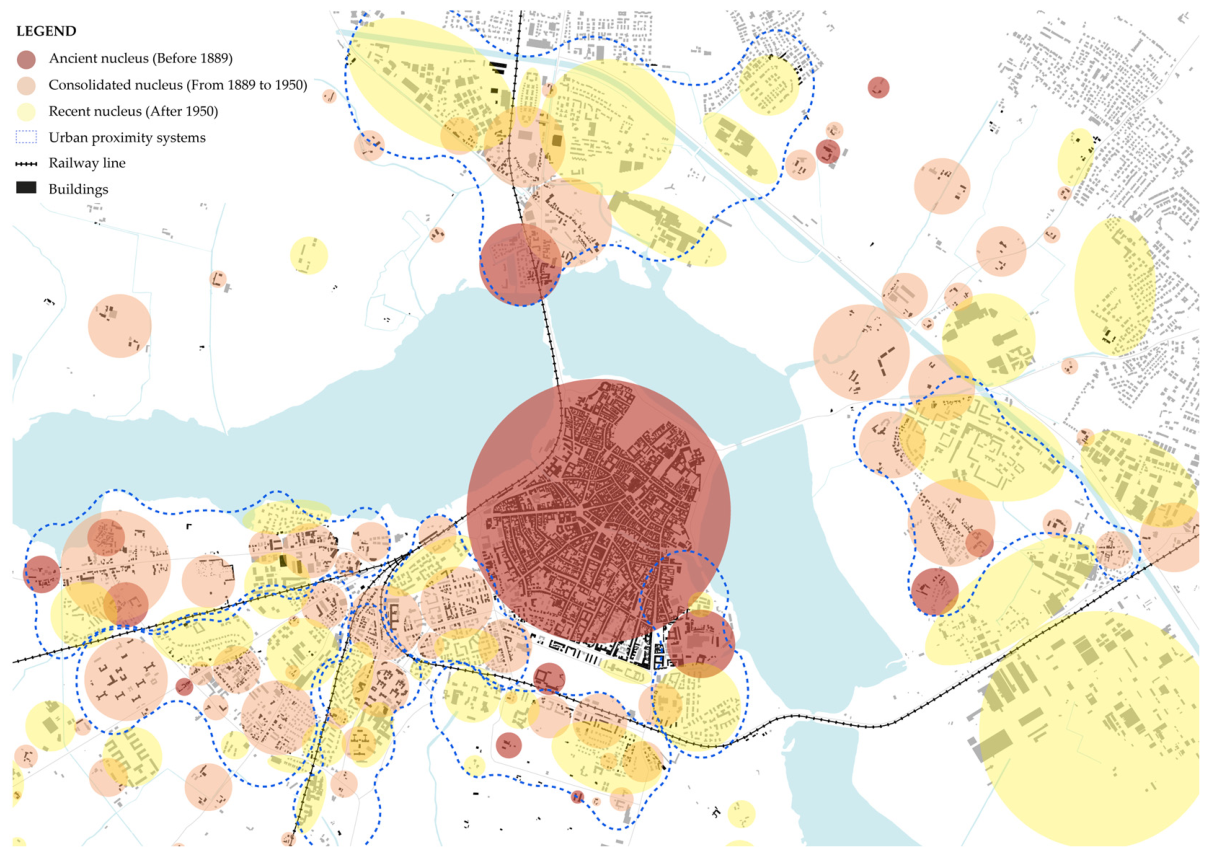
Within the territory of the city of Mantua, 8 proximity systems have been identified, capable of reinterpreting centralities and highlighting the intrinsic and extrinsic characteristics that define them (Figure 1). Intrinsic characteristics concern the constitutive elements of the individual systems, such as spatial structure, functions performed, population density, mobility, and accessibility to primary services. Extrinsic characteristics, on the other hand, highlight the relationships that these systems establish with surrounding systems, considering the physical, social, and economic connections that enable urban integration [26]. It is therefore possible to observe very different and complex urban geographies within the territory; moreover, the identity of each of these urban areas is determined by the system of relationships that characterizes it and that are expressed in the definition of a continuity of urban and extra-urban spaces, which build a system of interconnected networks capable of functioning both autonomously and in connection with other parts of the complex urban system. In this research, the eight urban proximity systems, located around the historic city center of Mantua, were used as a field of application.

3. Results

3.1. The Strategic Approach into the Proximity Systems

The definition of proximity systems made it necessary to experiment, in an integrated way, with the capacity of these systems to support a strategic-structural approach, based on the enhancement of two distinct but complementary lines of intervention. From this perspective, the urban project is considered a strategic tool aimed at outlining the conditions within which a widespread process of urban regeneration can develop across the territory, integrating urban and natural elements. This public reconfiguration, based on the definition of two backbones—one natural and one related to urban mobility—defines a set of strategies capable of restoring urban dynamism and promoting an improvement in quality of life. The key word of the project is connection. Connection, as a principle of territorial and urban relations, takes on the role of structuring correspondence, acting as a relational element and at the same time becoming both support and component of a much broader network, capable of connecting the city to the wider territorial context, linking to local and supra-local sites [34].

3.1.1. Ecological and Natural Backbone for the Enhancement of the Green System

There is an awareness of a certain inability to read and interpret a real continuity of green spaces within the territory, in favour of a fragmentation of the parts that compose it, and a lack of unity in the overall design, which reflects a general difficulty among designers in bringing together the different components of the project. The redefinition of the relationship with nature therefore represents an important challenge for contemporary cities, which must be capable of deepening an integrated and systemic approach to the design of green spaces. Starting from this evidence, the green system must be reintroduced within the urban plan according to a structural design that enhances continuity and the network paradigm rooted in the territory, improving urban and environmental quality of life. Over time, a complex understanding of environmental networks has developed, seen as a multidimensional and multiscalar framework for the resilient and landscape-oriented transformation of contemporary cities and territories [35]. Specifically, the objective of the ecological and natural backbone defined within the Services Plan is not limited to the mere preservation of biodiversity in environmental terms but also promotes an improvement in the quality of life of resident populations by fostering sustainable and resilient urban development. Alongside the need to build urban ecological networks dedicated to fauna, over time there has also emerged the opportunity to develop a more articulated territorial system, composed of extra-urban ecological networks and a system of urban natural networks for public use, enhancing the system of open spaces in relation to urbanized fabrics. In this sense, green space is used as a primary component of an operation of urban regeneration and integration between the consolidated city and the contemporary city characterized by dispersed settlement patterns. Within the Services Plan of the Municipality of Mantua, these reflections are developed and take concrete form in the “Ecological Network” map, where the strategy focuses on strengthening the protection of the environmental system, both within and outside urban areas, enhancing the systemic design of green spaces. Therefore, the main objectives guiding the project of this map are two:
  • Identify areas and connections characterized by significant natural qualities, existing or potential, enhancing the ecological and environmental heritage defined by the Provincial and Regional Ecological Network;
  • Identify a system of urban green spaces and strategic connections capable of improving quality of life, collective well-being, and environmental sustainability within the consolidated urban fabric.
The ecological network represents a strategy for safeguarding biological diversity based on connecting areas of significant environmental and natural interest into a continuous network, capable of restoring functional connections between ecosystems and, therefore, among populations of living organisms in fragmented environments. Ecological networks thus represent a concrete opportunity to redefine, even in anthropized territories, a more balanced relationship with the natural or semi-natural environment, enhancing biological capacities and promoting the maintenance of biodiversity [36]. In the ecological network project of Mantua, it was decided to consider this ecological-environmental network at the extra-urban level, that is, outside the consolidated urban fabric, starting from the definition of nodes and corridors divided into two main ecosystems, drawing on those defined in the “Green City Plan” approved in 2025 by the Municipal Administration:
-
River ecosystem, which constitutes an ecological corridor of also supra-local relevance, along which connections develop between habitats and natural and semi-natural systems linked to the main hydrographic network. It connects riparian zones, forests, and wetlands through corridors that allow the movement of species along waterways and surrounding ecosystems.
-
Agricultural ecosystem, which includes cultivated areas, rural and peri-urban spaces, and the semi-natural elements associated with them. It does not refer only to productive areas but also considers agricultural areas of interaction and those with landscape value located outside the consolidated urban fabric.
Within this complex design of the ecological network, two ecological infrastructures supporting the extra-urban network are also included, identifying the diversion road and the northern ring road of the Mantua area as two potential linear anthropogenic corridors, capable of integrating environmental mitigation strategies and connections with the defined natural systems. River and agricultural nodes in proximity to the urban fabric also represent natural points of interaction to which the ecological network project at the urban level is anchored and connected, to define a system of connections and nodes within the consolidated urban fabric of the city. The green areas enhanced in this project are identified in the “Services System” map and are classified into four types:
-
Agricultural, that is, areas primarily of agricultural value that mainly perform a function of continuity and connection with the extra-urban ecological network.
-
Multifunctional, that is, areas where recreational, sports, and social activities take place. They are mainly composed of parks, equipped areas, and sports facilities, serving as spaces for collective use and proximity.
-
Natural, that is, un-equipped green areas within the urban environment that mainly perform functions of connection or urban mitigation. These mainly include street greenery and environmental mitigation areas.
-
Potential, that is, impermeable or paved areas identified as potential spaces for renaturalization, depaving, and urban resilience actions, aimed at maintaining ecological continuity and reducing land consumption.
All these areas are interconnected by a multifunctional socio-environmental (urban) backbone that represents a support network for liveability, urban quality, health, and citizens’ well-being. For this reason, it performs a dual function within the territory:
-
Improve the quality of life of the community by offering people the opportunity to enjoy natural spaces through better access to parks and green areas and the creation of green routes that promote slow mobility and psychophysical well-being;
-
Ensure greater urban sustainability through mitigation and adaptation measures to respond to the challenges posed by climate change, defining increasingly resilient environments.
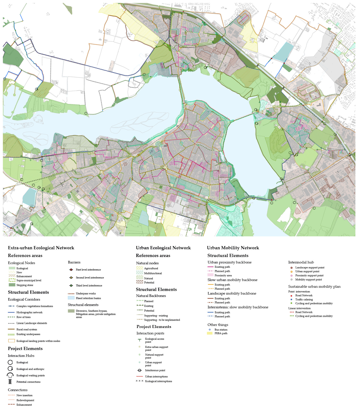
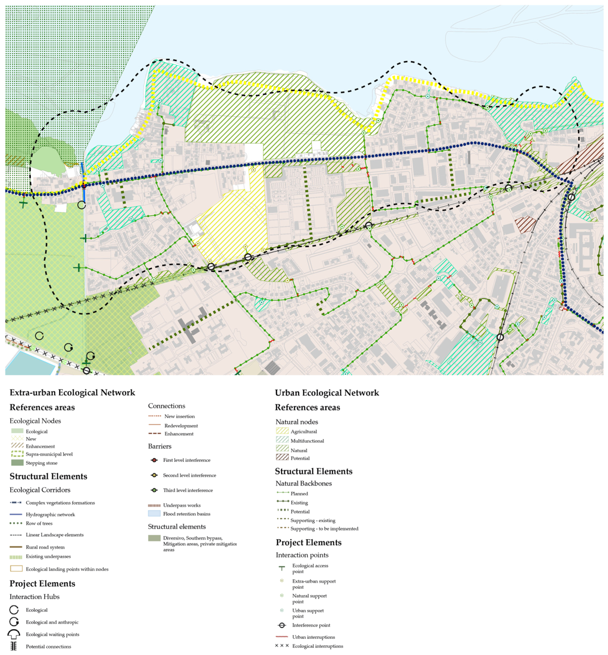
This backbone should not be considered a simple linear infrastructure, but must become an articulated network of linear elements, spaces, and green areas—both existing and potential—characterized by different environmental and social values, capable of improving the urban liveability of proximity systems [33]. In this sense, the aim is to promote ecosystem services within the city by defining ecosystems capable of contributing to the improvement of urban well-being and health [37]. They find application along these backbones through multifunctional nature-based solutions, such as Nature-Based Solutions (NBS), including permeable surfaces, green roofs, riparian forests, sustainable urban drainage systems (SuDS), rain gardens, and wetlands, which contribute to improving urban resilience and promoting sustainable development by increasing soil permeability [38]. It should be noted that, although the backbone has been developed for individual urban proximity systems, as shown in Figure 2, the same process has been applied to the entire territory, defining a systemic vision that has been included in the Services Plan.

3.1.2. Slow Mobility and Urban Proximity Backbone to Promote Urban Vitality

The pandemic and the intensification of climate change have highlighted a very fragile and vulnerable urban structure that requires re-organizing the city starting from the urban paradigm of proximity. In the field of urban planning, the concept of proximity is not new, as it has well-established theoretical roots, but it regained value during the pandemic period as an essential dimension in Carlos Moreno’s “15-min city” [39], which quickly became a manifesto for the development of the contemporary city. This model, while highly evocative, often reduces the concept of urban proximity to mere geographical closeness and physical accessibility to primary services reachable on foot or by bicycle, without, however, considering a system of dynamic relationships among people, spaces, and functions capable of promoting social cohesion and meaningful urban interactions.
In this project, it was decided to consider functional proximity—characterized by the diversification of functions and the integration of a mix of public spaces, residential areas, and productive activities—together with a relational proximity capable of fostering encounters, collaboration, and the construction of collective identities, intrinsic to the image of the city, its rhythms, and the ways of shared living, to generate dynamic environments, sociality, and new forms of community [2,3,4,5,6,7,8,9,10,11,12,13,14,15,16,17,18,19,20,21,22,23,24,25,26,27,28,29,30,31,32,33,34,35,36,37,38,39,40].
The backbone of slow mobility and urban proximity is configured as the structuring element capable of connecting the different spaces of the city, defining an articulated network that integrates public spaces, green areas, services, and other functional systems. In this way, it contributes to the construction of a human-scale city, enhancing functional nodes as epicentres of the public city. Living the city and its neighbourhoods, in fact, means sharing an urban space composed of heterogeneous elements—such as streets, parks, and public spaces—which must be included and organized within an integrated proximity-based project. From this perspective, the mobility system and public spaces are identified as the fundamental components of the backbone.
The mobility system strengthens the cycling and pedestrian network, integrating it with public transport, and makes it possible to connect different spaces and functions, shaping a network of everyday places, both open and built, capable of promoting inclusive, healthy, and safe environments. Public spaces, on the other hand, represent the main settings of citizens’ lives and constitute the reference infrastructure for planning and urban regeneration strategies based on proximity. They must be considered essential components of sustainable urban development, contributing to environmental conservation, resilience, and community well-being.
The slow mobility axis therefore aims to connect multiple functional nodes through a diversified network of links, improving urban accessibility and encouraging alternative modes of movement, in the direction of more sustainable development models. Its structure is based on the cycling routes identified in the municipal “Biciplan” adopted in 2014, a medium-term planning tool aimed at promoting the use of the bicycle as a priority means of transport. Starting from these routes, priority cycling and pedestrian paths have been identified in relation to the strategic centralities of the territory, with the aim of fostering functional reintegration within the urban system and organizing existing or planned facilities within accessible public or private spaces. In particular, two main directions can be distinguished: one of a landscape character, linked to the cultural and natural values of the territory and to the lake systems, which defines a slow mobility route at a supra-local scale; and one of an urban character, which develops within the settlement and ensures a continuous network of connections among the city’s public spaces, also in relation to the infrastructures of neighbouring municipalities [26]. Within this urban context, the theme of accessibility and social inclusion is also of particular importance: the routes have been designed in accordance with the guidelines of the PEBA (Plan for the Elimination of Architectural Barriers), to ensure full usability of public spaces and paths.
The integration of these principles makes it possible to transform the backbone not only into a connecting infrastructure, but also into an inclusive device, capable of responding to the needs of people with disabilities and more vulnerable groups of the population. While landscape routes foster interaction with the landscapes they traverse and with surrounding natural elements, within the urban context the slow mobility axis takes on the role of a dynamic element capable of integrating the places it crosses, strengthening the relationship between infrastructure and public space and contributing to the creation of an inclusive urban environment. In this sense, the backbone acts as a catalyst for local communities, contributing to the transformation of “spaces” into “places,” that is, contexts capable of generating social relationships and a sense of belonging experienced daily by local communities, to foster greater liveability [41]. Urban livability, understood as the overall quality of life perceived by residents, depends on multiple factors, including access to services, safety, social cohesion, and environmental conditions. In this context, public spaces play a central role, offering environments for social interaction, recreation, and cultural expression. They constitute privileged settings for experimenting with innovative and flexible solutions capable of adapting to constantly evolving needs. In the project of the Municipality of Mantua, urban parks, sports facilities, school areas under transformation, implementation plans, and parking areas have been identified as strategic spaces; these last three elements are considered potential resources for the urban reactivation of certain abandoned, degraded, or less attractive areas for the community. Furthermore, the identification of these spaces, even if not always fully usable, allows them to be rethought within the proximity network to foster greater urban dynamism and expand opportunities for their use, even at times and on days different from those in which they are usually accessible.
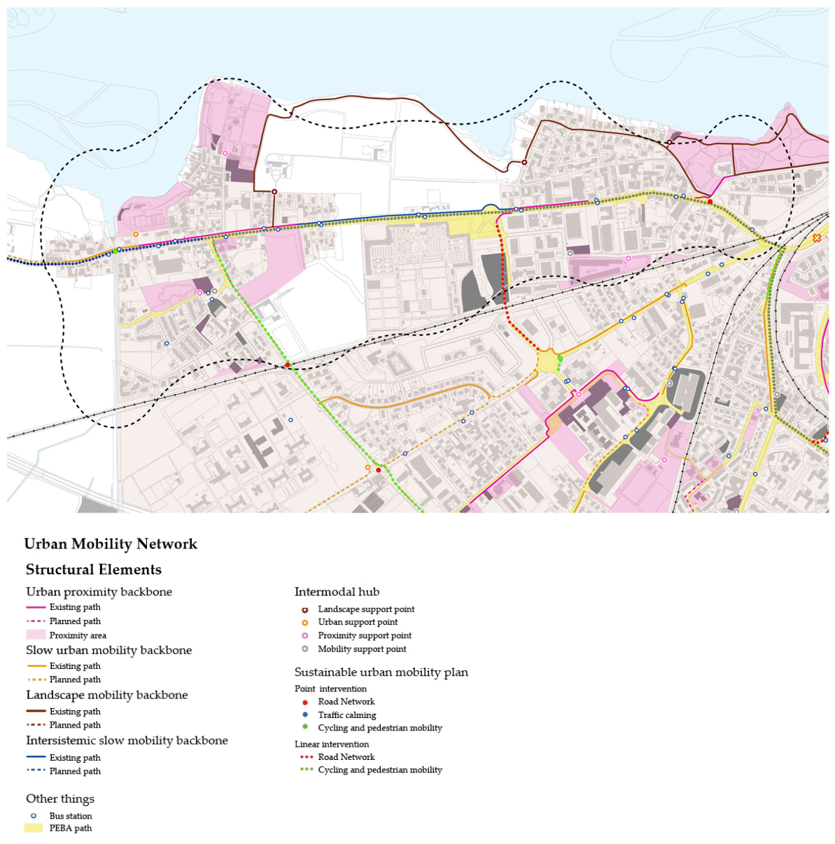
In this vision of public spaces distributed throughout the city, the quality and efficiency of the connections between them become essential, encouraging their use and supporting the performance of necessary, optional, and social activities [42]. In this context, the backbone of slow mobility plays a fundamental role in promoting active and sustainable lifestyles: pedestrian streets, cycling paths, and efficient public transport nodes encourage alternative modes of movement to private cars, contributing to the reduction in congestion and air pollution. The backbone is thus configured as an integrated device capable of activating processes of urban transformation, through the enhancement of pedestrian space, the development of cycling networks, the transformation of open and built spaces for temporary and flexible uses, and the strengthening of local services even beyond central areas. The improvement of accessibility and intramodality among proximity systems ultimately makes it possible to integrate infrastructures and services, contributing to the construction of a coherent territorial framework and to the enhancement of urban dynamics and overall sustainability. Also in this case, although the backbone has been developed for individual urban proximity systems, the same procedure has been applied to the entire territory, with an intersystemic value among its parts, as represented in one of the maps of the Services Plan (Figure 3).

3.2. A Systemic Vision Emerging from the Overlap of the Two Backbones

The project develops from a systemic approach that goes beyond the simple articulation of the two structuring backbones within individual proximity systems, extending the interpretation of connections and relationships to the scale of the entire territory. In this sense, the analysis highlights the importance of a multiscalar vision in which proximity systems, although conceived as autonomous and self-sufficient elements, must also be understood as parts of a network of territorial relationships and interconnections, essential for ensuring their functioning and promoting resilient and sustainable environments.
This dual interpretation of the territory present in the Figure 4, developed across different scales of analysis and intervention, made it possible to define an integrated reference framework capable of connecting urban and natural components, strengthening their reciprocal relationships and configuring a network of interconnected elements contributing to the construction of a more polycentric urban structure. This vision represents one of the key findings of the research, as it demonstrates how the integration of natural and ecological systems, transport infrastructure, public spaces and services can help move beyond a fragmented and highly monocentric urban model—one that is still prevalent in many contemporary cities today—by steering the area towards a more interconnected and polycentric spatial organization, based on strategies of urban proximity, sustainability and resilience. This approach has also made it possible to define integrated design guidelines, subsequently summarized in the final map of the Services Plan. Also, through the overlap of the ecological and natural backbone and the backbone of slow mobility and urban proximity, different urban conditions emerged as significant results of the research. On the one hand, the analysis identified planning nodes already characterized by a strong integration between environmental systems, public spaces, accessibility networks, and urban services, where targeted interventions can reinforce existing territorial qualities. On the other hand, the research highlighted contexts characterized by fragmentation, weak accessibility conditions, and limited interaction among territorial components currently governed by different processes and strategies. The ability to identify the most critical and priority areas for intervention represents a further significant outcome of the research, as it demonstrates how an integrated and systemic analysis of territorial components—both urban and natural—can support the identification of strategic areas in which to focus strategies for proximity, inclusion, resilience and sustainability, translating them into project actions capable of reconnecting and integrating diverse elements.
Within this framework, the different articulation of the structuring backbones enables the construction of a multilevel interpretation of the territory, which represents the latest significant result of the research, as it allows services, infrastructures, functional nodes, and green spaces to be related to one another, assigning each element a specific role within urban transformation processes and territorial dynamics. This approach highlights the need to orient the project toward integrated, systemic, and multiscalar forms of planning, capable of assuming a strategic role in guiding future urban transformations through a coordinated, adaptive, and resilient vision of the territory.

4. Discussion

The research highlights the need to rethink contemporary urban planning tools, which are still frequently characterized by rigid, sectoral and deterministic approaches, in favor of more adaptive and flexible planning models capable of integrating strategies and actions designed to address the complexity of the challenges facing the contemporary city. This perspective implies a paradigm shift in urban and spatial planning, geared towards the adoption of integrated approaches and systemic visions capable of linking urban, environmental, infrastructural and social components within an interconnected framework.
In this context, the Services Plan is one of the most important tools that Mantua City Council can use to address these changes effectively. It can no longer be interpreted solely as a regulatory instrument aimed at quantifying existing local resources and public services but must assume the role of a strategic framework capable of responding dynamically to the evolving needs of local communities and to the various territorial and social vulnerabilities. The research therefore promotes an integrated vision of planning, aimed at combining ecological and environmental needs with the social and functional needs of the contemporary city. From this perspective, the objective is to build more inclusive, accessible and resilient local urban systems, capable of improving urban quality and contributing to the achievement of sustainability goals, with reference to Goal 11 of the 2030 Agenda. Within this framework, the integration of green and blue infrastructure, transport networks, open public spaces and local services within a systemic and integrated vision enables the definition of targeted strategies and actions capable of promoting a more balanced distribution of services and facilities across the territory and of strengthening conditions of territorial equity, urban accessibility and social cohesion.
Furthermore, the historic city provides a significant testing ground for the application of integrated strategies to urban planning, as this particularly fragile and complex context requires the integration of conservation, transformation and innovation measures within a systemic vision of the area. The proposed methodological approach may also serve as a reference for other small and medium-sized European cities characterized by conditions like those of Mantua described above. However, the effectiveness of this project and process lies in the ability to recognize and interpret the characteristics of the local context, through an in-depth analysis of territorial and socio-demographic data that define the intrinsic characteristics of the territory and guide possible strategies within specific urban planning tools.

5. Conclusions and Future Direction

The revision of the Services Plan of the Municipality of Mantua, carried out in collaboration with the technical office, made it possible to develop certain insights regarding the role of traditional urban planning tools, which appear inadequate to respond to the current challenges that contemporary cities must address. In this sense, a paradigm shift is required in planning, which becomes integrated and strategic. Within the Services Plan, the issues we have sought to address through our research are:
  • The need to return to reinterpreting urban complexity starting from a spatial reconfiguration of the city, which makes it possible to reassess and reinterpret the role of services and public spaces considering the new qualitative needs of the city and the local community, returning to consider planning at the local and neighbourhood scale. In this regard, our work takes shape in the definition of proximity systems, which also represent the fields of application for strategies and actions.
  • The need to move from a quantitative vision of services, measured through traditional urban planning parameters and standards, to a qualitative assessment that considers the adequacy of services and their capacity to respond to the real needs of the population. Through the definition of a backbone of slow mobility and urban proximity, the aim is to promote the qualitative dimension of services, fostering urban proximity as a strategy for urban development.
  • The need to identify sustainable and resilient infrastructures capable of responding to increasingly frequent extreme climate events and the ongoing environmental crisis. Through the definition of the ecological and natural backbone, the aim is to promote integrated mitigation and adaptation strategies for ecosystem services, enhancing the green system and natural elements as environmental infrastructure that improves the quality of open spaces and promotes ecological and natural continuity across the territory.
  • The need to adopt a systemic and integrated vision of the territory requires complementarity between natural structuring elements, which foster biodiversity and ecosystem services, and anthropogenic urban elements, which define the urban structure of the contemporary city project in line with the objectives of sustainable development, particularly Goal 11.
These considerations must be integrated within a single urban planning tool capable of overcoming the traditional, rigid, deterministic, and predominantly quantitative structure. Contemporary challenges, indeed, require a strategic and integrated planning approach, capable of adapting flexibly to the new needs of the city and its communities. It is necessary to organize adaptive tools oriented toward defining a multiscalar and systemic vision, capable of combining an overall reading of the territory with attention to the specificities of individual urban contexts. This dual perspective makes it possible to address critical issues through coherent, targeted and context-specific measures, which cannot be applied uniformly across different regions but instead require specific, locally tailored approaches based on the intrinsic and extrinsic characteristics of each context.
At the same time, the research also has certain limitations that need to be highlighted. In particular, the strategies and initiatives linked to the two corridors have not yet been evaluated to determine the extent to which they can meet the needs of the resident population, nor has the real added value generated by proximity to these facilities been assessed in terms of accessibility, quality of life and the day-to-day realities of urban living. This type of analysis, developed using georeferenced systems, should therefore evaluate the strategies devised and implemented, including through a medium- and long-term monitoring phase capable of assessing the effectiveness of the proposed actions against the objectives set by the Municipal Administration.
A further limitation of the research concerns the fact that climate change and other contemporary urban challenges have so far been addressed by urban planning tools primarily as conditions linked to the present, without fully integrating the dimension of uncertainty into planning processes. In this sense, the use of scenario-based approaches could represent a significant methodological advance, useful for interpreting future urban transformations and supporting forms of planning that are more adaptive and flexible in response to the city’s present and future needs. From this perspective, the involvement of local communities could also constitute an added value for the research, fostering the shared development of strategies and projects capable of responding more effectively to the real needs of citizens and improving the quality of urban space. Building on these premises, the research aims to explore, from a future-oriented perspective, the integration of scenario-based models within territorial governance tools, with a view to guiding urban development through differentiated and adaptable strategies capable of steering transformations within a dynamic and constantly evolving framework.

Author Contributions

Conceptualization, M.B. and C.P.; methodology, M.B., C.A. and C.P.; software, M.B.; validation, M.B., C.A. and C.P.; formal analysis, M.B., C.A. and C.P.; investigation, M.B. and C.P.; resources, M.B.; data curation, M.B. and C.P.; writing—original draft preparation, M.B., C.A. and C.P.; writing—review and editing, M.B.; visualization, M.B., C.A. and C.P.; supervision, C.P.; project administration, C.P.; funding acquisition, C.P. All authors have read and agreed to the published version of the manuscript.

Funding

The APC was covered by institutional resources provided by Politecnico di Milano.

Data Availability Statement

The data presented in this study are available on request from the corresponding author due to privacy/ethical restrictions.

Conflicts of Interest

The authors declare no conflict of interest.

References

  1. Cheshmehzangi, A. Urban planning for the Contemporary Age: Navigating Complexities and Shaping Urban Futures. Encyclopedia 2025, 5, 19. [Google Scholar] [CrossRef]
  2. Manzini, E. Abitare la Prossimità. Idee per la Città dei 15 Minuti; Egea: Milan, Italy, 2021. [Google Scholar]
  3. UN-HABITAT. Planning Sustainable Cities. Global Report on Human Settlements 2009; UN-HABITAT: Nairobi, Kenya, 2009; Available online: https://unhabitat.org/sites/default/files/download-manager-files/Global%20Report%20on%20Human%20Settlements%202009%20Planning%20Sustainable%20Cities.pdf (accessed on 18 April 2026).
  4. UN-HABITAT. UN-Habitat Practices and Perspectives. United Nations Human Settlements Programme; UN-HABITAT: Nairobi, Kenya, 2022; Available online: https://unhabitat.org/sites/default/files/2022/06/wcr_2022.pdf (accessed on 18 April 2026).
  5. ICOMOS. The Future of Our Pasts: Engaging Cultural Heritage in Climate Action. Outline of Climate Change and Cultural Heritage; Technical Report; ICOMOS: Paris, France, 2019; Available online: https://civvih.icomos.org/wp-content/uploads/Future-of-Our-Pasts-Report-min.pdf (accessed on 18 April 2026).
  6. UN—United Nations. New Urban Agenda; United Nations: New York, NY, USA, 2017; Available online: https://habitat3.org/the-new-urban-agenda/ (accessed on 18 April 2026).
  7. Magni, F.; Musco, F. Verso una città climate proof: Strumenti e politiche innovative per il governo del territorio in uno scenario di cambiamento climatico. In Proceedings of the XX Conference of the Italian Society of Urbanists (SIU): Cambiamenti. Responsabilità e Strumenti per L’urbanistica al Servizio del Paese, Catania, Italy, 16–18 June 2016; Planum Publisher: Rome, Italy; Milan, Italy, 2016; Available online: https://air.iuav.it/retrieve/de164c2a-6d6a-60ee-e053-3a05fe0a7787/Magni_Musco.pdf (accessed on 18 April 2026).
  8. Borini, M.; Peraboni, C. Riconoscere la complessità urbana a partire dalle nuove consapevolezze della città: Alla ricerca di sistemi di prossimità urbana. Urban. Inf. 2021, 168, 6–8. [Google Scholar]
  9. Peraboni, C. Cities are diverse, complex, and dynamic systems. How can we plan them in a resilient direction? In Proceedings of the 6th International Conference on Changing Cities VI, Rhodes, Greece, 24–28 June 2024. [Google Scholar]
  10. Orioli, V.; Massari, M. Praticare L’urbanistica. Traiettorie tra Innovazione Sociale e Pianificazione; FrancoAngeli: Milan, Italy, 2023. [Google Scholar]
  11. Ochoa, W.A.A.; Neto, A.I.; Junior, P.C.V.; Calabokis, O.P.; Ballestores, V. The Theory of Complexity and Sustainable Urban Development: A Systematic Literature Review. Sustainability 2025, 17, 3. [Google Scholar]
  12. UN-HABITAT. Cities and Climate Action. World Cities Report 2024. United Nations Human Settlements Programme; UN-HABITAT: Nairobi, Kenya, 2024; Available online: https://unhabitat.org/world-cities-report-2024-cities-and-climate-action (accessed on 18 April 2026).
  13. Giaimo, C. Ri-pianificare la città. Urban. Inf. 2024, 314, 5–6. [Google Scholar] [CrossRef]
  14. Carta, M. Nuovi paradigmi per una diversa urbanistica. Commento al libro di Gabriele Pasqui. Casa della Cultura, 17 January 2019. Available online: https://www.casadellacultura.it/851/nuovi-paradigmi-per-una-diversa-urbanistica (accessed on 18 April 2026).
  15. Pasqui, G. Coping with the Pandemic in Fragile Cities, 1st ed.; Springer Nature: Cham, Switzerland, 2022. [Google Scholar]
  16. Campos Venuti, G. La Terza Generazione Dell’urbanistica; FrancoAngeli: Milan, Italy, 1994. [Google Scholar]
  17. Bevilacqua, G. La Città Storica e la Nuova Questione Urbana. Strategie e Strumenti per la Rigenerazione nel Piano Urbanistico Locale. Ph.D. Thesis, Sapienza Università di Roma, Rome, Italy, 2020. [Google Scholar]
  18. Acierno, A.; Pistone, I.; Scaffidi, L. Un approccio integrato per la pianificazione urbana multiscalare. Riv. Internaz. Cult. Urban. 2018, 11, 119–138. [Google Scholar]
  19. Secchi, B. Un Progetto per L’urbanistica; Einaudi: Turin, Italy, 1989. [Google Scholar]
  20. Semeraro, T.; Zaccarelli, N.; Alejandro, L.; Sergi Cuccinelli, F.; Aretano, R. A bottom up and top down participatory approach to planning and designing local urban development: Evidence from an urban university center. Land 2020, 9, 98. [Google Scholar] [CrossRef]
  21. Cellamare, C. Costruire un approccio integrato e ripensare l’azione pubblica. Esplorare un’ecologia delle relazioni nei contesti urbani. Antropol. Pubblica 2025, 1, 241–269. [Google Scholar]
  22. Giaimo, C. Innovazione dei piani e del governo del territorio: Prospettive emergenti dei Servizi ecosistemici. Urban. Inf. 2016, 265, 50–53. [Google Scholar]
  23. Gabellini, P. Avvicinarsi all’urbanistica. In Approaching Urbanism; Planum Publisher: Milan, Italy, 2024. [Google Scholar]
  24. Fistola, R. La “non-city” e il disegno delle reti urbane. Urban. Inf. 2015, 263, 1–2. [Google Scholar]
  25. Oliva, F.; Galuzzi, P.; Vitillo, P. Progettazione urbanistica. In Materiali e Riferimenti per la Costruzione del Piano Comunale; Apogeo Education: Milan, Italy, 2002. [Google Scholar]
  26. Borini, M. From quantitative to qualitative services: How to promote integrated planning for the revision of the service plan of Mantua, Municipality in Italy. Sustain. Dev. Cult. Tradit. 2025, 11a, 66–84. [Google Scholar]
  27. Lombardy Region. Regional Law 11 March 2005, No. 12: Legge per il Governo del Territorio; Lombardy Region: Milan, Italy, 2005; Available online: https://normelombardia.consiglio.regione.lombardia.it/normelombardia/accessibile/main.aspx?view=showsum&iddoc=lr002005031100012 (accessed on 18 April 2026).
  28. Rossitti, S.; Tiboni, M.; Zazzi, M. Il ruolo delle tecniche urbanistiche per progettare la prossimità urbana. Urban. Inf. 2021, 300, 34–39. [Google Scholar]
  29. Russi, N. Progettazione alla scala locale. I Nuclei di identità locale del Pgt di Milano. In Welfare e Territorio. Esplorare il Legame Tra Politiche dei Servizi e Dimensione Urbana; Pomilio, F., Ed.; Alinea: Florence, Italy, 2009; pp. 133–146. [Google Scholar]
  30. Balducci, A.; Fedeli, V.; Pasqui, G. Strategic planning for contemporary urban regions. In City of Cities: A Project for Milan, 1st ed.; Routledge: London, UK, 2011. [Google Scholar]
  31. Wang, M. Polycentric urban development an urban amenities: Evidence from Chinese cities. Environ. Plan. B Urban Anal. City Sci. 2021, 48, 400–416. [Google Scholar] [CrossRef]
  32. Rauhut, D. Polycentricity: A Critical Discussion. In Proceedings of the 56th Congress of the European Regional Science Association, Vienna, Austria, 23–26 August 2016. [Google Scholar]
  33. Borini, M. Re-read the urban complexity into planning tools through the definition of urban proximity systems. The case study of Mantova. In Proceedings of the 6th International Conference on Changing Cities VI, Rhodes, Greece, 24–28 June 2024. [Google Scholar]
  34. Peraboni, C. Riserva di biosfera UNESCO “Po grande”, un’opportunità per riflettere su salvaguardia, gestione e pianificazione del territorio. Urban. Inf. 2020, 289, 1–5. [Google Scholar]
  35. Gasparrini, C. Infrastrutture verdi e blu. Una priorità nazionale per la pianificazione urbanistica e la coesione territoriale nei prossimi anni. Urban. Inf. 2019, 282, 45–47. [Google Scholar]
  36. Peraboni, C. Reti Ecologiche e Infrastrutture Verdi; Maggioli: Santarcangelo di Romagna, Italy, 2010. [Google Scholar]
  37. Giaimo, C.; Salata, S. Rigenerazione Urbana e Buon uso Del Suolo: Mappare e Valutare i Servizi Ecosistemici Alla Scala Locale. Esperienze dal Progetto Life Sam4cp; Urban@it–Centro Nazionale di Studi per le Politiche Urbane: Bologna, Italy, 2017; Available online: https://www.urbanit.it/wp-content/uploads/2017/10/BP_Giaimo_Salata.pdf (accessed on 18 April 2026).
  38. ICLEI—Local Governments for Sustainability. Nature-Based Solutions for Sustainable Urban Development. Global Platform for Sustainable Cities. Available online: https://www.thegpsc.org/sites/gpsc/files/iclei_nature_based_solutions_eng_0.pdf (accessed on 18 April 2026).
  39. Moreno, C. The 15-Minute City: A Solution for Saving Our Time & Our Planet; John Wiley & Sons Inc.: Hoboken, NJ, USA, 2024. [Google Scholar]
  40. Marchigiani, E.; Bonfantini, B. Urban Transition and the Return of Neighbourhood Planning. Questioning the Proximity Syndrome and the 15-Minute City. Sustainability 2022, 14, 5468. [Google Scholar] [CrossRef]
  41. Corsini, D.; Peraboni, C. Spazi Pubblici. Visioni Multiple per Spazi Complessi; Maggioli Editor: Santarcangelo di Romagna, Italy, 2011. [Google Scholar]
  42. Gehl, J. Cities for People; Island Press: Washington, DC, USA, 2010. [Google Scholar]
Figure 1. Polycentric vision of the city of Mantua with the eight urban proximity systems. Source: Authors’ elaboration.
Land 15 00935 g001
Figure 2. Design of the ecological and natural backbone for the Belfiore and Borgo Angeli urban proximity system, including related legend. Source: Authors’ elaboration.
Land 15 00935 g002
Figure 3. Design of the mobility and proximity backbone for the Belfiore and Borgo Angeli urban proximity system, including related legend. Source: Authors’ elaboration.
Land 15 00935 g003
Figure 4. Overlapping of the two different backbones for the entire City of Mantua. Source: Authors’ elaboration.
Land 15 00935 g004
Table 1. Demographic analysis of Mantua’s population from 2017 to 2024.
Survey YearResident
Population
Variation from
Previous Year
Variation
Percentage
Survey
Year
Resident
Population
Variation from
Previous Year
Variation
Percentage
201749,480--202149,316−55−0.11%
201849,529490.10%202249,5912750.56%
201949,585560.11%202349,8282370.48%
202049,371−214−0.43%202450,3445161.02%
Table 2. Natural and Social Replacement dynamics of the Resident Population in 2023.
2023
NeighborhoodBirthDeathEnrolledCancelledResidentsNatural Replacement IndexSocial
Replacement
Index
Belfiore41043269481.48%7.28%
Borgo Angeli813364213381.57%5.83%
Dosso del Corso1022604714112.27%7.58%
Borgochiesanuova13211348422851.49%9.54%
Pompilio17261158521532.00%9.29%
Due Pini1320205230.76%7.65%
Te Brunetti1216444912782.19%7.28%
Fiera Catena99524511231.60%8.64%
Valletta Valsecchi134715911129042.07%9.30%
Valletta Paiolo3815738619969582.80%8.41%
Centro8621784060016,6871.82%8.63%
Colle Aperto15248210619152.04%9.82%
Cittadella9121178612191.72%16.65%
Ponte Rosso7297336341.42%20.50%
Virgiliana3923385352.24%11.40%
Lunetta273918315937521.76%9.12%
Frassino 61146137412.29%7.96%
Gambarara2939324982.21%14.26%
Disclaimer/Publisher’s Note: The statements, opinions and data contained in all publications are solely those of the individual author(s) and contributor(s) and not of MDPI and/or the editor(s). MDPI and/or the editor(s) disclaim responsibility for any injury to people or property resulting from any ideas, methods, instructions or products referred to in the content.