Article

Walking Routes for Marginal Territories: An Unfulfilled Opportunity? A Study in the Inner Areas of the Forlì-Cesena Apennines


by
Gabriele Manella
1,
Ángel Rodríguez-Pallas
2,* and
Tommaso Rimondi
3
1
Department of Sociology and Business Law, University of Bologna, 40125 Bologna, Italy
2
Department of Humanities, Faculty of Tourism, University of A Coruña, 15001 A Coruña, Spain
3
Department of Civil, Chemical, Environmental, and Materials Engineering, University of Bologna, 40136 Bologna, Italy
*
Author to whom correspondence should be addressed.
Land 2026, 15(5), 784; https://doi.org/10.3390/land15050784
Submission received: 7 April 2026 / Revised: 3 May 2026 / Accepted: 5 May 2026 / Published: 7 May 2026

Abstract

This paper examines several trends in contemporary tourism: the broadening of the very notion of a “tourist destination”, alongside the growing importance of providing a diversified and territorially integrated supply; the opportunities that tourism may offer to some “marginal” areas; and the impact of the COVID-19 pandemic, which calls for a rethinking of more sustainable and responsible forms of travel, both for the environment and for the people encountered along the way. Tourism related to walking routes and trails appears to benefit from all of these trends, and indeed, this segment has shown clear growth in Italy. The paper then considers the potential and critical issues of this sector in Forlì-Cesena County, with a focus on the nine Apennine municipalities included in the National Strategy for Inner Areas (SNAI). Through an analysis of local tourism promotion websites, a secondary analysis of statistical data, and 19 questionnaire–interviews with local stakeholders, this study examines an area where tourism is growing but remains largely concentrated on the coast. Although the potential of walking routes is confirmed by the various itineraries crossing this area, their actual use and impact on local development still appear limited.

1. Introduction

One of the trends that characterise contemporary tourism is the broadening of the concepts of “tourism product” and “tourist destination”. At the same time, a combination of factors has turned tourism into a major development opportunity even for territories without a historical vocation. This is especially true of marginal territories affected by economic, demographic, and social fragilities. This became even clearer during the pandemic, and arguably also in the post-pandemic period, leading to the rediscovery of proximity tourism and to greater attention to the environment and local heritage.
The idea underpinning this paper is that walking routes (cammini) may benefit from all of these trends. On the one hand, they cross different localities and create opportunities for mutual collaboration. Moreover, they represent a prominent form of sustainable and responsible tourism, respectful of natural and cultural heritage as well as of local populations. Finally, walking routes can represent a core resource for marginal territories such as those included in the National Strategy for Inner Areas (SNAI), developed between 2012 and 2013 by the Italian Ministry for Territorial Cohesion.
In this paper, we focus on these changes and potentials in the case of the Forlì-Cesena County (FC), in Emilia-Romagna, and in particular on the nine municipalities included in the SNAI: Bagno di Romagna, Civitella di Romagna, Galeata, Portico e San Benedetto, Premilcuore, Rocca San Casciano, Santa Sofia, Tredozio, and Verghereto [1].
Through a secondary analysis of statistical data sources, we examine recent trends in tourist flows and local accommodation capacity.
We then analyse official local tourism promotion websites and draw on interviews with local actors to discuss the potential and critical issues of walking routes as an opportunity for development in these inner areas as well as the impacts of the 2023 floods.

1.1. “New Spaces” and “New Tourists” in Contemporary Tourism

Sociology has long examined the characteristics of tourism in the transition from industrial to post-industrial society. Without seeking to cover such a complex debate exhaustively, we would like to mention two critical trends:
  • Tourist behaviour. This transition in the relationship between travellers and society can be summarised as a shift “from the importance of being like the others to the importance of being different”. During the so-called Thirty Glorious Years (roughly the 1950s–1970s), mass tourism expanded as part of the consolidation of industrial society, rising incomes, paid holidays, and more standardised forms of leisure consumption. In that context, holidays were often associated with collective rhythms, social imitation, and relatively homogeneous tourism practices. In contrast, in contemporary society, holidays have become increasingly individualised experiences: rather than functioning mainly as a compensatory break from everyday life or as a confirmation of belonging to a broader social model, they are more often linked to self-affirmation, personal values, and differentiated preferences within a context marked by weaker social reference points and the crisis of major institutions such as the family, the church, the state, and large enterprises [2].
  • Destinations. There has not only been a proliferation of possible attractions, but also an increasing importance attached to proposing a tourist supply across a wider territory, addressing different targets and encouraging public–private collaboration. In an increasingly global market, competition is less about price than about the ability to enhance one’s distinctive features and to think from a more “regional” and less “local” perspective [3].
If all these trends have been visible for decades, crises can nonetheless intensify or redirect them, often with significant effects on tourism and the wider economy. The COVID-19 pandemic was an especially severe example of this. In Italy—which up to 2019 derived about 13% of its GDP from tourism—the sector lost around half of the total arrivals and overnight stays in 2020 and as much as 60–70% of international flows. As in many countries worldwide, the effects of the crisis extended into 2021: approximately 289.2 million overnight stays, +38.7% compared with 2020 but still −33.8% compared with 2019 [4]. Only in 2022 did tourism show clear signs of recovery, returning to pre-pandemic levels in 2023, with more than 134 million arrivals and 451 million overnight stays in accommodation establishments in Italy, the highest value ever recorded [5].
The pandemic therefore did not simply interrupt tourism flows; it also accelerated tendencies already visible in contemporary tourism, including stronger demand for slow and low-density mobility, outdoor experiences, greater attention to health and perceived safety, and travel forms regarded as more sustainable and more respectful of local material and immaterial heritage [6,7,8,9].

1.2. Walking Routes: A Growing Sector

Walking routes are one of the oldest forms of “tourist” travel. Some routes can be traced back to Greco-Roman times, and in the Middle Ages, pilgrimages involved such a flow of pilgrims that dedicated structures became necessary to organise travel and hospitality [2]. In recent years, however, the trend has grown considerably, and alongside emblematic examples such as the Camino de Santiago de Compostela, the phenomenon has spread across many European and extra-European countries.
Through slowness, physical effort, and the continuity of the route, walking produces an intense relationship with the space traversed in which landscape, local communities, and minor infrastructures become constitutive elements of the tourist experience [10]. In the post-pandemic context, walking gains further value as a form of mobility shaped by a new attention to time, health, and psycho-physical well-being [11].
Within the Italian debate, walking routes have attracted sociological attention mainly in relation to pilgrimages; walking as an experience of relationship with, and knowledge of, a territory has received limited attention so far [12,13]. This gap combines with the difficulty of obtaining accurate data, as walking tourism often overlaps with hiking and is affected by the various difficulties in monitoring walkers’ movements. If we consider some recent data estimates, however, there were more than 190,000 walkers in Italy in 2024, about 24% more than in 2023, with over 1.4 million overnight stays along official itineraries [14]. A more detailed picture emerges from the annual report Italia, Paese di Cammini [15]. Its latest edition combines data from contacts with 160 route managers (122 responses) and an online survey of walkers (4622 responses). Credentials (a document issued at the start of the route to register stages) amounted to 122,338 in 2024 in Italy, +17.8% compared with 101,162 in 2023. The increase in Testimonium—a certificate of completion of a route—is even clearer: from 57,842 in 2023 to 73,604 in 2024 (+21.8%). The report stresses that these numbers show a combination of growth trends: in routes issuing credentials, in the number of short routes, and in the number of people who complete a route. This is even more significant if we consider that in 2017, only six Italian routes issued credentials, and only 17,988 were distributed. Notably, in 2020—when spring was severely marked by COVID—credentials still numbered 38,624, a decline far smaller than in other tourism segments.
The survey of walkers also confirms that women now slightly outnumber men: 51% versus 49%. This is a gradual but steady increase, given that in 2018, women numbered around 40%. Another clear trend is walking with others: 74% of respondents travel with another person or in a group. As for motivations, while 26% still choose a route for religious or spiritual reasons, the majority also mention the desire to feel better, to get to know new places, to be in close contact with nature, or to engage in physical activity. Finally, the growing relevance of walking routes in Italy is also reflected in estimates of the sector’s economic impact: 1,450,000 overnight stays by walkers in 2024, with 52% spending at least 40–50 euros per day. These national data help outline the general profile of walkers in Italy, but they do not allow us to reconstruct the specific composition of walkers in the Forlì-Cesena Inner Area in terms of local excursionists, domestic visitors from other regions, or foreign visitors.
Overall, this report [15] points to clear growth in this tourism segment, with multiple potential positive effects on the territories crossed by these walking routes. However, national growth trends should not be mechanically projected onto all local contexts: as the Forlì-Cesena case later shows, Inner Area municipalities may display much weaker tourism performance despite the increasing visibility of walking routes.

1.3. Inner Areas: Between Marginality and Development Trajectories

As noted above, walking tourism has experienced significant growth in the post-COVID period. Although its volumes remain limited compared with mass-tourism flows, this segment is particularly relevant because it is predominantly concentrated in rural, mountain, and marginal territories, often overlapping with the so-called Inner Areas. In the Italian policy framework, Inner Areas are defined as those parts of the national territory characterised by a significant distance from centres providing essential services, especially education, healthcare, and mobility. Their marginality therefore refers not only to geographical remoteness, but also to differentiated access to services, demographic fragility, and uneven development trajectories [16,17].
International research on rural and peripheral destinations suggests that tourism development outcomes depend not only on territorial resources, but also on governance arrangements, stakeholder participation, and residents’ perceptions of tourism-related costs and benefits. In fragile or peripheral settings, local support helps shape the social legitimacy of tourism strategies and influences whether tourism is perceived as generating collective benefits or merely external pressures. This has been shown both in UNESCO heritage destinations and in small peripheral protected areas, where residents are increasingly recognised as key actors in sustainable tourism governance and place-based development [18,19].
In this context, Inner Areas have progressively been seen as “refuge spaces”, in symbolic opposition to hyper-concentrated tourism sites. In practice, this means that geographic isolation may be reinterpreted positively as remoteness, tranquillity, authenticity, and distance from overcrowded destinations, thereby becoming part of the symbolic and cultural appeal of these territories. The increase in overnight stays along itineraries in these areas may foster micro-local economies based on family hospitality, agritourism, small restaurants, and small-scale accommodation, contributing to a redistribution of tourism benefits.
However, perhaps even more significant is the generation of social and relational capital. Hospitality along routes often becomes a form of “informal welfare”, based on volunteering networks, non-standard hospitality practices, and proximity relations, which reinforce a sense of social value and recognition within host communities. From this perspective, community-based tourism offers a useful complementary framework for interpreting the developmental role of walking routes in Inner Areas. In both rural and remote settings, the literature shows that tourism is more likely to contribute to local development when it is grounded in community participation, collective benefit, and multilevel governance, with social capital operating as a necessary condition rather than an automatic outcome [20,21]. At the same time, walking experiences in Inner Areas often represent a first contact with territories perceived as alternatives to dominant urban models, opening up possibilities for return, temporary stays, or hybrid projects, without necessarily translating into structurally stable migration processes [22,23].
This perspective combines temporary mobility and symbolic reterritorialisation, and contributes to redefining the centre-periphery relation in post-COVID tourism. Yet the current expansion phase may also lead to overburdening walking routes with a “salvific” function for Inner Areas’ problems, generating excessive expectations and compensatory narratives. Walking routes cannot replace structural territorial development policies; rather, they operate as incremental tools, effective only if integrated into broader, multilevel strategies [24]. From this perspective, there is a clear need to strengthen the link between walking trail tourism and regional development policies, in particular the SNAI. Walking routes could be seen not only as tourism products, but as ‘light’ territorial infrastructures, capable of contributing to broader objectives such as strengthening local services, supporting territorial maintenance, and boosting the local economy. In this sense, their relevance to hydrogeological safety would be indirect rather than automatic, insofar as route maintenance, monitoring, accessibility works, and the continuous presence of local actors may help sustain greater territorial attention in fragile environments. However, this integration still appears to be limited.
From a conceptual point of view, this paper interprets walking routes not simply as tourism products, but as place-based territorial infrastructures. Their developmental effects depend on whether they are embedded in broader territorial strategies capable of coordinating accessibility, local services, environmental management, and small-scale entrepreneurship [25]. Recent literature on rural tourism routes and eco-cultural trails suggests that the value of such itineraries emerges less from the route itself than from the way it is integrated into local governance, service provision, and territorial cooperation [26]. This perspective is particularly relevant in Inner Areas, where demographic fragility and distance from essential services make tourism development highly dependent on coordinated place-based action. In this sense, the weak effects observed in the study area suggest that walking routes do not automatically activate endogenous development; rather, their contribution depends on how territorial capital is organised through local governance, services, and entrepreneurial networks.

2. Materials and Methods

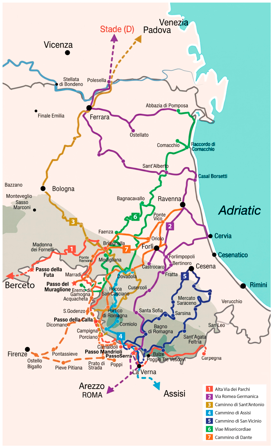
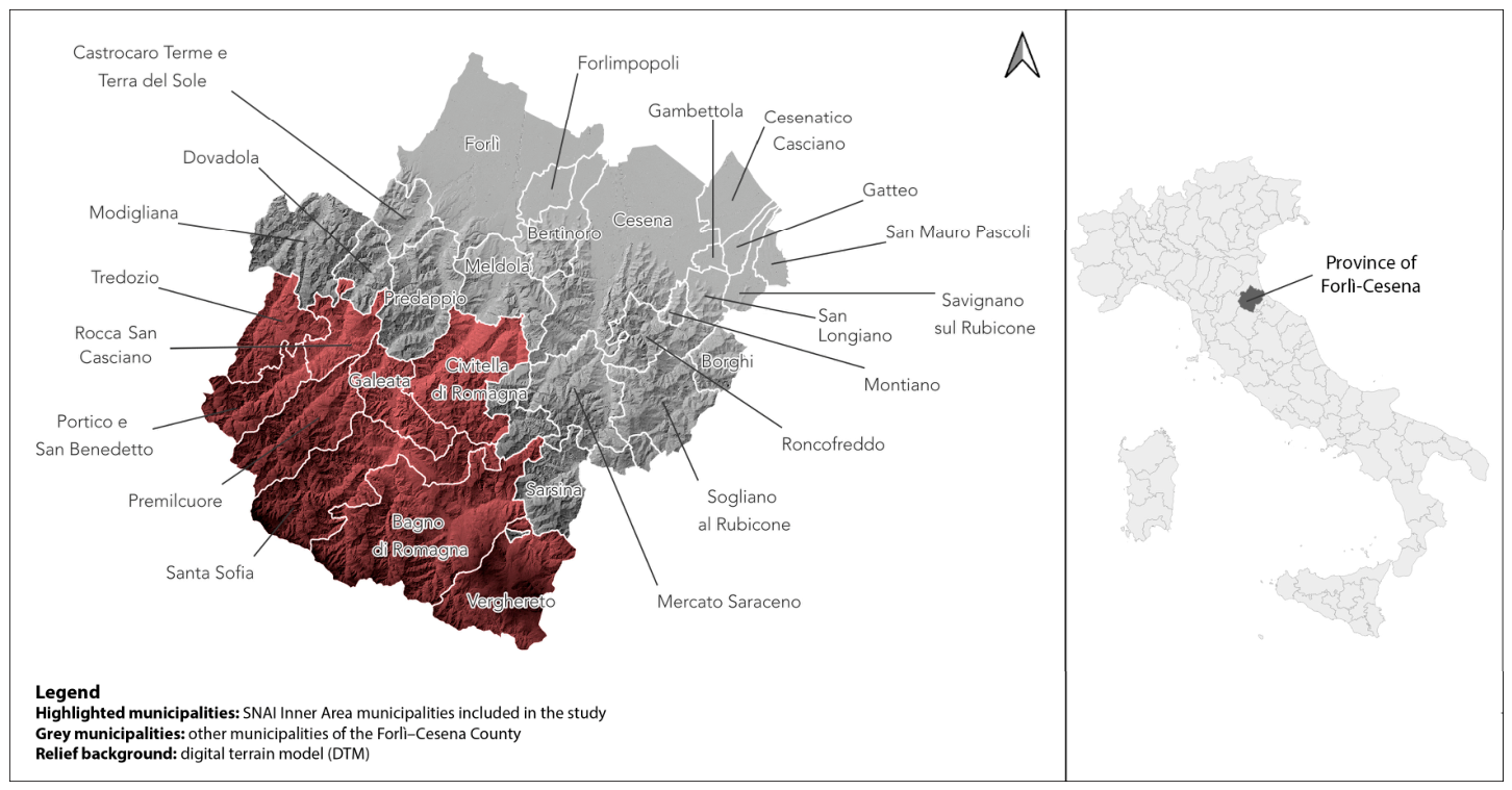
Figure 1 and Figure 2 were prepared as illustrative cartographic materials to support the geographical contextualisation of the study area. Figure 1 was based on cartographic material published by Provincia di Forlì-Cesena [27] and was developed using QGIS version 3.40 “Bratislava”, with final visual editing and layout adjustments carried out using Adobe Photoshop version 22.5.8. Figure 2 was adapted from cartographic material published by APT Servizi Emilia Romagna—Cammini Emilia-Romagna [28], available under a Creative Commons BY-SA licence, and was edited using Adobe Photoshop version 22.5.8. No laboratory or technical equipment was used in this study.

2.1. The Forlì-Cesena County: Between Historical Problems and Emerging Resources

The Forlì-Cesena Apennines: A Framework

The Forlì-Cesena County, in the eastern part of Emilia-Romagna, is divided into thirty municipalities (Figure 1), all with fewer than 50,000 inhabitants except for the two main cities: Forlì (117,974 residents as of 31 October 2025) and Cesena (95,627).
ISTAT (Istituto Nazionale di Statistica) and the Emilia-Romagna regional government divide these municipalities into [29]:
  • “Riviera”: the ones on the Adriatic coast (Cesenatico, Gatteo, San Mauro Pascoli, Savignano sul Rubicone);
  • “Large municipalities”: with at least 50,000 inhabitants (Forlì, Cesena);
  • “Spa towns”: the ones with a spa facility (Bagno di Romagna, Castrocaro Terme e Terra del Sole, Bertinoro);
  • “Hill towns”: Borghi, Civitella di Romagna, Dovadola, Galeata, Mercato Saraceno, Modigliana, Montiano, Predappio, Rocca San Casciano, Roncofreddo, Sarsina, Sogliano sul Rubicone, Tredozio;
  • “Apennine towns”: Premilcuore, Portico e San Benedetto, Santa Sofia, Verghereto;
  • “Other towns”: Forlimpopoli, Gambettola, Longiano, Meldola.
If “minor” territories can benefit from many opportunities within contemporary tourism, and if data show the growth of walking routes in Italy, this combination is particularly important for Inner Areas [30], which are significantly distant from centres providing essential services (education, health, mobility), rich in important environmental and cultural resources and highly diversified both by natural features and centuries of human settlement [31] (p. 5). As stated in the Partnership Agreement 2014–2020, Inner Areas represent about 53% of Italian municipalities (4261) and account for about 23% of the resident population and over 60% of the national territory.
Isolation and distance have become—first within the National Strategy for Inner Areas and then in many specific interventions—distinctive traits for a renewed valorisation of Inner Areas’ natural and cultural resources [32,33]. As a consequence, tourism becomes linked to the recovery of artistic and unused building heritage, to the recovery of older traditions and economic chains, and to the enhancement of natural landscapes [34]. This process is also affected by risks and contradictions, since peripheral location and poor accessibility may undermine the use that these policies aim to promote [35].
For the area we considered in this study, it should first be noted that since 2022, nine municipalities in the Forlì-Cesena County have been included on the list of Italian Inner Areas, with the ensuing funding opportunities: Bagno di Romagna, Civitella di Romagna, Galeata, Portico e San Benedetto, Premilcuore, Rocca San Casciano, Santa Sofia, Tredozio, and Verghereto, with a total of around 21,800 inhabitants [36] over an area of 953 sq km. This area is therefore sparsely populated, but, as noted above, its inclusion among the Inner Areas has attracted increasing institutional attention in recent years.
From a geographical and environmental perspective, the nine municipalities studied are located in the hilly and mountainous areas of the Forlì and Cesena Apennines, along the Tuscan-Romagna border. This is a territorially fragmented area characterised by valleys, passes, forest landscapes, and a strong environmental vocation, including parts of the National Park of the Casentinesi Forests, Monte Falterona, and Campigna [37,38]. The territory also includes a number of well-known natural and tourist landmarks, such as Monte Fumaiolo and the Ridracoli Dam, which contribute to its attractiveness while also confirming its strong dependence on environmental resources [39,40,41]. More broadly, the study area combines low population density, mountain morphology, and significant ecological value, all of which are relevant for understanding both its tourism potential and its infrastructural and environmental fragilities.
It was within this regional backdrop that the flood tragedy unfolded. A fatal combination of heavy and prolonged rainfall, flooding, river overflows, and landslides struck the Emilia-Romagna region and parts of the Marche region between 2 and 17 May 2023, causing 17 victims and damage amounting to approximately €8.5 billion [42].
The floods particularly affected the eastern part of Emilia-Romagna, including the thirty municipalities of the Forlì-Cesena County, all of which were affected across their entire territory [43]. In addition, the tragic chain of events prompted criticism from numerous national and local institutions, which highlighted inadequate local land management; the regional government, in particular, was accused of failing to address the issues of hydrogeological instability in recent years. As for land use, while Emilia-Romagna is the only region in Italy to have enacted a regional law on this matter (2017), there are a number of building types and projects that are exempt from the 3% annual limit set by the law. This “tolerance”, combined with a local economy that returned to vigorous growth as early as 2021, has contributed to sustained land take dynamics in Emilia-Romagna, a region that remains among the Italian regions most affected by soil consumption processes [44].
Despite this situation, this disaster has also prompted a strong response from institutions and citizens. Given the number and variety of stakeholders and funding sources involved, it is difficult to provide a fully comprehensive account of the activities undertaken to assist the population and to rebuild and secure the area. If we focus on Forlì-Cesena, however, around seventy interventions for approximately €106 million have been recorded.
The nine municipalities of our study are also beneficiaries of some of these interventions: they are mentioned in two orders issued by the Special Commissioner, 8/2023 (slope stabilisation in Galeata and Premilcuore) and 15/2023 (restoration of the Savio River defence system in Bagno di Romagna, Sarsina, and Verghereto). They have also been allocated funds from the Italian National Recovery and Resilience Plan (PNRR), including interventions for slope stabilisation and hydrogeological risk reduction in Verghereto, Santa Sofia, Bagno di Romagna, and Premilcuore, as well as from the European Regional Development Fund (ERDF) for hydrogeological risk mitigation in Civitella [45].

2.2. The Walking Routes’ Network: A Significant Growth

In this area, which is clearly rich in attractions but also dramatically affected by natural disasters, what opportunities are available for walkers? First, numerous regional routes now exist, seven of which cross the study area [46]. Figure 2 shows these seven routes and illustrates their broader territorial development in relation to the study area. Of these seven routes, one is the Alta Via dei Parchi; five belong to the so-called “Pilgrim Ways”, a group of regional routes (cammini) linked to itineraries already used in the Middle Ages; and one, the Cammino di Dante, is not a pilgrim trail but a historically inspired loop route.
  • Alta Via dei Parchi (about 500 km), opened in 2009 after a project proposal by the Emilia-Romagna regional government, consists of 27 stages from Berceto (Parma) to Carpegna (Pesaro-Urbino) [47]. By examining the whole route and overlaying it onto the nine municipalities included in our study area, we found that the itinerary crosses one of them: Portico e San Benedetto.
  • Via Romea Germanica (about 2200 km), which from Augsburg descends into the Po Plain, crosses the National Park of the Casentinesi Forests, and reaches Rome, retracing the route taken in the 13th century by the Dominican abbot Albert of Stade [48]. It is linked to various national associations, and its Italian headquarters are in Santa Sofia. The route also passes through Bagno di Romagna.
  • Cammino di Sant’Antonio (433 km), created in 2010 by the Conventual Franciscan Friars, connecting places significant to the Saint’s life from Camposampiero (Padua) to the sanctuary of La Verna (Arezzo). Within the Forlì-Cesena territory, it crosses Rocca San Casciano and Portico e San Benedetto, passes through the Casentinesi Forests National Park, and includes the hermitage of Monte San Paolo as a prominent site [49].
  • Cammino di Assisi (285 km), promoted by a group of Franciscan friars and combining ancient itineraries centred on Saint Anthony and Saint Francis. Currently managed by the association of the same name, it ends in Assisi and starts from Dovadola (in the Province of Forlì-Cesena). Among the municipalities in our study, it passes through Portico e San Benedetto, Premilcuore, Santa Sofia, and Tredozio [50].
  • Cammino di San Vicinio (about 320 km), a loop route starting and ending in Sarsina and running through places linked to the life of this local saint; regarding the nine municipalities of our study, it passes through Bagno di Romagna and Verghereto. The modern itinerary was launched in 2009 by local administrators and the parish priest; key services such as signposting and website management are coordinated by the non-profit association Il Cammino di San Vicinio [51].
  • Viae Misericordiae (245–250 km), starting from the Abbey of Pomposa (Ravenna) and reaching Faenza (Ravenna). Established in 2018, its main services have been managed since the following year by the Compagnia Beato Nevolone association. Among the municipalities studied, it crosses Tredozio [52].
  • Finally, we also note the Cammino di Dante (about 380 km), which is not a pilgrim trail but a loop route connecting Ravenna to Florence, inspired by the main stages of Dante’s journey to the city at the beginning of the 14th century. Established in 2012, the route is managed by the non-profit cultural association Il Cammino di Dante. Within the study area, it passes through Portico e San Benedetto and Premilcuore [53].
Taken together, these routes confirm that the study area is embedded in a broader network of regional walking itineraries (Figure 2). At the same time, their territorial distribution is uneven: some municipalities are crossed by several routes, whereas others are only marginally included in the regional network (Figure 2). This confirms that the study area is well-positioned within a broader system of walking itineraries, but also that the territorial intensity of route presence is uneven across the area.
In order to assess whether and to what extent walking routes are present in the territorial promotion of the area, our study considered the official online promotion platforms: the websites of the nine municipalities and the two main local tourism promotion sites (Turismo Forlivese and Emilia-Romagna Turismo). In practical terms, the website review was guided by four descriptive criteria: (a) the visibility of walking routes within the site architecture; (b) the amount and specificity of route-related information (e.g., route descriptions, maps, stages, practical information, and references to services); (c) the presence of search and filter functions useful for route planning; and (d) the relative prominence of walking routes compared with other territorial attractions. The aim was not to produce a formal quantitative content analysis but a structured qualitative assessment of the extent to which walking routes were incorporated into official destination promotion. All of the available sections were accurately consulted, and both revealed a number of positive features: the two platforms have recently been redesigned, are content-rich, detailed, visually appealing, and allow personalised searches by locality, available time, and thematic area. A recurring theme on both sites is the image of the Apennine zone as a place of peace and relaxation as well as of contact with nature, facilitated by a rich network of routes and trails. However, in both cases, we found that relatively limited space was devoted to the routes discussed above. There is substantially greater visibility for the National Park of the Casentinesi Forests, Monte Falterona, and Campigna (founded in 1993), which also extends across parts of our study area. As for the nine municipal websites, our impression is that they are primarily devoted to administrative information and event announcements, while tourism promotion is likely delegated to the two aforementioned portals.

2.3. Qualitative Design, Sampling, and Analysis

The qualitative component was designed as an exploratory stakeholder study rather than a representative survey. Potential respondents were identified through municipal webpages, local associative networks, and tourism-related online sources, and were grouped into three categories: municipal administrations, Pro Loco/local associations, and food/accommodation enterprises. All identified actors (n = 65) were contacted by email and invited to complete a questionnaire–interview combining closed questions with open-ended prompts. Data collection was conducted between January and March 2026, that is, well after the May 2023 flood events discussed in this paper. This temporal positioning is relevant because the respondents’ assessments of route conditions, tourism attractiveness, and local vulnerability were expressed in a context already shaped by recent hydrogeological disruption and its aftermath. The analytical aim was not to achieve statistical generalisation, but to identify recurring interpretive patterns across actor types. Accordingly, the adequacy of the corpus was assessed in relation to analytical specificity rather than response rate alone: the study addressed a narrow set of questions, involved a highly specific group of local stakeholders, and sought recurrent interpretive patterns across three predefined actor categories. In line with the information-power approach to qualitative sampling, and with recent evidence that focused qualitative studies often reach analytical saturation with relatively small samples, this corpus was considered adequate for the exploratory aims of the study while remaining limited in terms of transferability [54,55].
Open-ended answers were analysed through thematic analysis, following the six-phase approach proposed by Braun and Clarke [56]: familiarisation with the material, generation of initial codes, clustering of codes into candidate themes, review of themes across the dataset, theme definition, and interpretive writing-up. To improve transparency, we compared the recurrence of specific themes across the three actor groups and paid attention not only to convergence, but also to uncertainty and dissent. In line with the COREQ and SRQR reporting principles [57,58], the qualitative findings should therefore be read as analytically informative but not statistically representative.
The final corpus included 19 completed responses (29.2% of contacted actors), all of them from the nine SNAI municipalities included in the study area. No municipality was left unrepresented. The distribution of responses was as follows: Bagno di Romagna (2), Civitella di Romagna (1), Galeata (2), Portico e San Benedetto (2), Premilcuore (1), Rocca San Casciano (2), Santa Sofia (3), Tredozio (3), and Verghereto (3). In terms of actor type, the final corpus comprised 6 respondents from municipal administrations, 5 from Pro Loco or local associations, and 8 from food service or accommodation enterprises. This uneven but complete territorial coverage further confirms the exploratory nature of the qualitative evidence, which remains analytically informative but limited in terms of transferability beyond the study area.

3. Results

3.1. Tourist Flows in the Forlì-Cesena County

Given this background on walking routes and trail-related supply, one of our research questions is how local tourist attractiveness has changed in recent years. The analysis is therefore structured at two territorial scales. Forlì-Cesena County is considered first in order to reconstruct the broader tourism context within which the nine SNAI municipalities are embedded, including the strong coastal concentration of flows and the uneven post-pandemic recovery across the province. The nine SNAI municipalities then constitute the primary analytical focus of the study, since they represent the Inner Area targeted by this research. In this sense, the county-level evidence is used mainly as a comparative framework for interpreting the more specific dynamics observed in the selected municipalities.
To address this question, we began with a secondary statistical analysis of arrivals and overnight stays in 2024 across Forlì-Cesena County, comparing them with 2019, the last pre-pandemic year. As shown in Table 1, the overall situation appears positive, with flows in 2024 exceeding those of 2019 both for arrivals (1,183,196; +3.4%) and for overnight stays (5,709,136; +5.0%). Yet, once we disaggregate by area, the distribution is heterogeneous.
First, there is a strong territorial imbalance, with tourist flows still highly concentrated in the three coastal municipalities (Cesenatico, Gatteo, San Mauro Pascoli). In 2024, these accounted for 772,447 arrivals (65.3% of the provincial total) and 4,535,330 overnight stays (79.4%).
Considering arrivals, the biggest 2019–2024 increases emerged in the “other municipalities of the Forlì Apennines” (+42.2%) and in the “Forlì hill municipalities” (+16.8%), but also in less well-known localities such as Longiano (+19.0%) and Savignano sul Rubicone (+12.9%). Regarding the two main cities, we observed opposite trends: Forlì has not yet recovered the pandemic gap (−11.6%), whereas Cesena has (+2.9%). Significant declines have also been recorded in some hill and Apennine towns such as Bertinoro (−45.3%) and Santa Sofia (−37.5%).
For overnight stays, the 2019–2024 picture showed both similarities to and differences from the pattern observed for arrivals. In this case, both main cities showed strong recovery, especially Forlì (+24.3% in 2024 compared to 2019) but also Cesena (+13.2%). Meldola, adjacent to Forlì, also grew clearly (+22.9%). Consistent with arrivals, “other Apennine municipalities” and “hill municipalities” also grew (+12.8% and +7.9%). The sharp decline of Bertinoro and Santa Sofia was also confirmed in overnight stays (−22.3% and −40.7%). This may reflect the heterogeneous local structure of tourism recovery within the county. In both cases, recovery appeared weaker than in coastal and main urban municipalities, suggesting greater vulnerability in more specialised or fragile local tourism contexts, especially after the 2023 flood. In the case of Santa Sofia, this reading is also consistent with the later evidence on declining accommodation capacity and broader Inner Area fragility.
Thus, while the overall situation is positive, the area displays a “patchwork” pattern, with several areas experiencing declines or at least still failing to return to pre-pandemic levels.
Regional data, however, did not allow for a disaggregated analysis for all thirty municipalities of FC County. In order to proceed, we also considered the ISTAT data for the nine municipalities included in the SNAI, considering both tourist flows (Table 2) and accommodation capacity (Table 3). In both cases, we compared the 2019 data (last pre-pandemic year) with the 2024 data (first fully post-pandemic year).
Regarding arrivals and overnight stays, data were available for only seven of these municipalities. For Galeata and Rocca San Casciano, no municipal-level data were available in the regional statistical series (Table 2). This suggests that tourism monitoring in Inner Areas may remain uneven at the municipal scale, which in turn limits the precision of fine-grained territorial assessment. However, Bagno di Romagna and Verghereto showed growth in arrivals, more than compensating for declines in the other five (Civitella di Romagna, Portico e San Benedetto, Premilcuore, Santa Sofia, and Tredozio). For overnight stays, however, the available data showed a general decline, with strong drops in Portico e San Benedetto (−46.8%), Premilcuore (−34.1%), and Santa Sofia (−40.7%) (Table 2). This ambivalent trend between arrivals and overnight stays suggests a shortening of the average length of stay, and therefore of the local capacity to retain tourist flows.
If we consider accommodation capacity (hotels and non-hotels), we found that the number of establishments in 2024, compared with 2019, had declined in six SNAI municipalities, whereas the number of available beds declined in all nine SNAI municipalities (Table 3). Unlike the oscillations observed in flows, the contraction of accommodation capacity signals a structural downsizing of the tourism supply.
This finding can be interpreted in several ways.
First, it may confirm a decline in attractiveness experienced by this area in recent years, or at least an inability to return to pre-pandemic levels, unlike many other parts of Emilia-Romagna and Italy.
Second, although we lacked data specifically attributable to walking-trail tourism, the increasing presence of routes in the area does not seem to have produced significant effects on tourist flows. In terms of policy implications, this gap between the availability of walking routes and the low impact on tourist flows suggests that this segment is unlikely to increase local attractiveness unless combined with structural improvements (accessibility, services, accommodation capacity). This highlights the need to integrate tourism policies with infrastructural and local development ones, as suggested by the SNAI place-based approach.
Third, the strong impact of hydrogeological instability due to the 2023 flood has very probably contributed to the closure of some businesses, and in some cases, made territories even less “walkable”.

3.2. Potentials and Criticalities of Walking Routes: The Interviews

Regarding the perception of local tourism attractiveness, the responses showed a broadly positive view among the participants: sixteen out of nineteen considered their municipality fairly or very attractive. Regarding motivations, nature and landscape were by far the most frequently mentioned: all respondents referred to them, highlighting them as the real strength of their area. Just three of them, however, explicitly mentioned trekking opportunities as an attractiveness factor, and no one specifically mentioned the official walking routes available in these municipalities.
When asked specifically about the attractiveness of their municipality for walking routes, seventeen out of nineteen considered their territory fairly or very attractive for this segment. This suggests that even if walking routes are not the first thing that come to mind, they still constitute an important part of local territorial heritage. At the same time, this points to an initial expectation–performance gap: walking routes were widely perceived as territorially attractive, yet this perception did not correspond to equally strong evidence of tourism performance in terms of overnight stays and local accommodation dynamics.
Perceptions of tourist flows in recent years were more divided: only six respondents perceived an improvement compared with the pre-pandemic period, while the other thirteen perceived stability or a decline. Although these questionnaire–interviews were not representative, this remained an interesting finding, also because it is not fully consistent with the picture emerging from the statistical data, which, as seen above, points to a widespread decline in flows in the Inner Area municipalities and a general contraction in accommodation capacity. This divergence may also reflect an uneven awareness of tourism dynamics across local actors, especially where perceptions are shaped more by direct local experience than by aggregated statistical trends.
Regarding the potential impact of a walking route within their territory, we asked respondents about two dimensions: economic development and cultural opportunities. Regarding the first, there was a very high level of agreement: sixteen out of nineteen respondents considered it fairly or very important. In their view, walking routes could benefit commercial and accommodation activities along the route, but also increase the visibility of the territory as a whole. Regarding the second dimension, there was also very strong consensus: fifteen out of nineteen. In particular, they thought that a walking route could foster cultural opportunities by encouraging the rediscovery of local history, traditions, and identity. For tourists and walkers, moreover, it could offer an opportunity to learn about local cultural heritage alongside natural heritage. For local schools and cultural associations, the trail may become an educational tool and a means of promoting festivals and events. The less positive responses were too few to support a distinct interpretive profile; however, taken together, they suggest a degree of skepticism about the actual capacity of walking routes to generate concrete local effects in the absence of stronger services, visibility, and territorial integration.
However, once we consider the “real” impact, the perplexity of respondents increased considerably. Asked whether walking tourism fosters a deeper relationship between travellers and the local community, only five respondents agreed, eight disagreed, and the other six did not know. Similarly, when asked whether the presence of the walking route had fostered the development of sustainable economies locally, only six out of nineteen thought that this had happened to some extent or to a large extent, whereas the other thirteen thought it had happened ‘not very much’ or ‘not at all’. We thus observed a clear gap between the potential of walking routes and what they had actually generated locally thus far. When interpreting these results, however, it should be borne in mind that almost all routes crossing these nine municipalities were relatively recent: with the exception of the Via Romea Germanica, the others were established within the last twenty years. It is therefore reasonable to assume that their local rootedness was not yet strong; as a consequence, this also affected the perception of their impact on tourism and regional development.
In the next part of the questionnaire–interview, we addressed the Inner Areas dimension more directly by asking whether respondents perceived advantages from the inclusion of their municipality in the SNAI. As expected, this was a more “technical” question, and not all respondents were able to answer either about the impact of funding or about the effects on essential services (eight and six out of nineteen answered “I don’t know”). Overall, the perceptions appeared more positive in the first domain (six out of nineteen thought that the benefits were fairly or very significant), whereas perceptions were markedly lower in the second (only two respondents thought that there were benefits). Once again, inclusion in a national development strategy did not appear—at least not yet—to have improved local services. This finding aligns with national-scale assessments of the SNAI, which has encountered many obstacles in its attempt to increase the provision of essential services in Inner Areas. This finding suggests a need for greater integration between the various local policies. Walking trails could act as catalysts for local services (accommodation, transport, maintenance), indirectly contributing to the SNAI’s aims. However, such integration still appears to be weak in the case we studied.
A further key topic for our study was the impact of hydrogeological instability on tourism, and in particular, on trails and walking routes in light of the 2023 floods in Romagna. Many areas of the Forlì-Cesena Apennines have been dramatically affected: the nine municipalities studied were included among those flooded across their entire territory, as seen in Section 2. Interviewees confirmed this perception (fourteen out of nineteen considered their municipality fairly or very affected), and a similar pattern emerged regarding damage to local trail and route networks (fourteen out of nineteen). Despite the efforts made (twelve out of nineteen respondents acknowledged that damaged routes were reopened through extraordinary interventions or rerouted), there was a strong perception that improvements had been very limited.
The situation remains delicate, also because, as noted above, processes of depopulation, de-anthropisation, and isolation accumulated over decades have made Inner Areas highly environmentally vulnerable [59]. Today, in a historical context marked by climate change, this vulnerability is being exacerbated, triggering a territorial vicious circle.
In the final section of our questionnaire, respondents were asked about the potential and challenges of the Apennine region. Most respondents (ten out of nineteen) were aware that being part of an Apennine Inner Area made their territory more vulnerable. It is nonetheless interesting to ask about the possible contribution—both direct and indirect—that walking routes may make to mitigating this critical issue. Although respondents saw this contribution as currently very limited, they almost unanimously agreed on the potential importance of these itineraries in promoting territorial conservation (eighteen out of nineteen), preventing hydrogeological instability (twelve out of nineteen), and fostering greater environmental awareness among the local population (sixteen out of nineteen). All of these elements reinforce the impression that the walking trail sector remains something of an unfulfilled project in these areas, partly due to the recent natural disasters and partly due to internal development dynamics.

4. Discussion: What Real Impacts Beyond the Rhetoric of Walking Routes?

It is clear that walking tourism is a growing phenomenon, thanks to a combination of sectoral trends—some multi-decadal, others more recent, particularly after the COVID-19 pandemic. Walking is understood not only as travel, but also as an experience of meaning and relationship with oneself, with others, and with the environment. Slowness, connection with nature, and the involvement of local communities make it an alternative form of tourism, and at least in theory, much more responsible than global mass tourism.
With regard to the development trajectories of Inner Areas, tourism has often been presented as an “all-season solution” applicable to any territory. Each Inner Area municipality could, in theory, engage with the tourism market through a form of “unused territorial capital” that includes not only food and wine products, natural resources, and traditions, but also a diffuse historic and architectural heritage, stratified cultural landscapes, artisanal know-how, traditional productive practices, and in the case of walking routes, networks of slow mobility and territorial use. Such an offer, if properly developed and promoted, could attract people and capital seeking to escape the city. In particular, the existence of a hedonistic neo-ruralism [60] has been highlighted, centred on the values of “authenticity” and “slowness”, as opposed to frenetic urban life.
These visions tend to crystallise Inner Areas into “postcard landscapes”, places to be consumed and largely passive with respect to development processes triggered by urban populations and capital [61]. Inner Areas thus find themselves in a dependent position in relation to external flows (often seasonal and volatile) that do not necessarily consolidate the local social and economic structures, and may instead generate processes of selection and identity simplification oriented more toward urban demand expectations than toward endogenous development trajectories. Moreover, representing tourism and the valorisation of territorial capital as a near-automatic solution to marginalisation—capable of activating economic development and repopulation—neglects the structural factors underpinning marginalisation: infrastructural gaps and limited accessibility, lack of essential services, and demographic fragility. Research on resident perceptions in mature territorial destinations likewise suggests that the legitimacy and effectiveness of tourism strategies depend on whether local communities perceive concrete benefits for residents as well as for the destination itself [18].
Forlì-Cesena County responded well to the tourism crisis during the pandemic period, but recovery has not been homogeneous and some territorial imbalances persist. The nine SNAI municipalities are among the most vulnerable: the strong presence of walking routes and trails represents an interesting lever for proximity tourism, but the promotion efforts implemented by local government, if not embedded in a broader territorial strategy, risk being ineffective in terms of tackling marginalisation.
From a territorial-capital perspective, the central issue is not whether Inner Areas possess resources, but whether environmental, cultural, relational, and infrastructural assets can be effectively activated through governance arrangements capable of coordinating services, accessibility, maintenance, and local entrepreneurship. Territorial capital does not refer only to local endowments as such, but also to the set of place-specific assets that can support endogenous development when mobilised through coherent place-based strategies. Recent work on Italian Inner Areas has also shown that classifications based only on accessibility to essential services may overlook important territorial-capital differences and therefore risk producing insufficiently tailored interventions. In this sense, our findings point not so much to the absence of territorial capital as to difficulties in governing and converting it into stable local benefits: walking routes exist, are recognised locally as attractive, and intersect with broader cultural and environmental resources, yet these assets are not being translated into longer stays, stronger local expenditure, or more resilient service provision because coordination between tourism promotion, service provision, environmental management, and territorial planning remains weak [62,63].
This pattern is also consistent with wider evidence on Italian Inner Areas. Previous studies have shown that these territories often display significant environmental and cultural resources, but also marked heterogeneity in their capacity to convert such assets into stable development outcomes. In this respect, the Forlì-Cesena SNAI municipalities do not differ because they lack territorial potential, but because that potential remains only partially translated into longer stays, stronger accommodation systems, and more robust local spillovers. Compared with more successful or better-integrated Inner Areas, the present case appears to be characterised by weaker coordination between tourism promotion, service provision, and territorial maintenance, as well as by the added constraint of recent hydrogeological disruption [32,33].
These dynamics are not unique to the Forlì-Cesena case. Research on remote rural areas across Europe shows that many such territories face recurring constraints in transport infrastructures, access to essential services, low household income, population decline, and ageing, even when they possess valuable natural assets and landscape resources. Comparative work on sustainable mountain development likewise suggests that mountain regions often register more positive economic effects than socio-cultural or environmental ones, and that governance, cooperation, and the ability to retain value locally help explain these uneven outcomes. From this perspective, the Forlì-Cesena Inner Areas should be understood not as an isolated anomaly, but as a locally specific expression of broader challenges affecting fragile mountain and remote rural regions [64,65].
Taken together, the quantitative and qualitative results point in the same direction. The statistical evidence shows that in the SNAI municipalities, arrivals are only partially recovering, whereas overnight stays and accommodation capacity have generally declined. The interviews add an important nuance: local actors still perceive their territories as highly attractive from an environmental and cultural point of view, yet they do not perceive walking routes as having generated strong economic effects so far. This divergence may be read as a local expectation–performance gap. Walking routes are widely valued as important territorial assets, yet their actual effects are perceived as limited in terms of overnight stays, local spillovers, and service consolidation. This reading is consistent with studies showing that residents often attribute high importance to tourism development goals while evaluating their concrete local performance more critically, especially when the expected benefits are not translated into visible improvements for residents, community well-being, and destination quality. It also aligns with research on resident perceptions in other territorial destinations, which shows that local support for tourism-related strategies depends strongly on whether communities perceive tangible collective benefits rather than merely additional pressures or external gains [18,66,67]. This also suggests that inclusion in the SNAI framework does not automatically translate into stronger tourism performance at the municipal level, and that the developmental role of walking routes depends on how local conditions interact with broader place-based strategies and service provision. In other words, the problem is not the absence of territorial capital, but the weak conversion of that capital into longer stays, local expenditure, and business consolidation (see Table 2 and Table 3 and Section 3.2).
The gap between route availability and local development can be explained by several structural and organisational constraints. Walking routes do not function as isolated tourism assets: their effectiveness depends on supporting services, accessibility, public services, basic infrastructure, and coordinated management [25]. Recent research on rural tourism routes shows that cooperation among stakeholders, adequate tourist and public services, and integrated governance are all central to generating synergies and sustainable territorial benefits [25]. Likewise, studies on eco-cultural trails stress that sustainable trail development requires coordinated management of landscape, cultural, and natural assets rather than a narrow focus on the itinerary itself [26]. In fragile mountain territories, these conditions become even more important in contexts where accommodation networks are thin, and hydrogeological instability directly affects route continuity, maintenance, and perceived safety.
Recent literature suggests that walking tourism can support rural revitalisation and local development, but only when routes are integrated into broader territorial strategies [68]. In environmentally fragile rural areas, route-based tourism not only requires promotion, but also maintenance capacity, monitoring systems, reliable visitor information, and data-based management tools [69]. This is particularly relevant where trail continuity and safety may be compromised by extreme weather events and hydrogeological instability. From this perspective, the developmental role of walking routes depends on whether they are governed as territorial infrastructures: signage, maintenance, monitoring, accessibility, and coordination with local service networks are not secondary elements, but preconditions for durable local benefits.
The limitation, in short, is not only promotional, but structural and environmental. Walking routes and trail-based tourism can provide several direct and indirect levers for local development, but in order to have a real impact, it is necessary to act comprehensively on a series of factors that currently limit its possible spillovers.
The interviews clearly confirm the perception that the territory has significant potential, but that—partly because of the 2023 natural disasters—it still struggles to generate strong tourism growth. Although we cannot establish a direct causal link between the flood events and the contraction of accommodation supply, the temporal coincidence between these phenomena suggests the need for further investigation. Establishing such a link would require longitudinal municipal- or establishment-level data on overnight stays, bed capacity, business closures, and route accessibility. It would also require spatially explicit measures of flood exposure and damage intensity. Quasi-experimental designs comparing affected municipalities with similar unaffected ones over time—such as difference-in-differences or synthetic control approaches—would make it possible to distinguish disaster effects from broader post-pandemic and structural trends. Recent tourism-disaster studies have used precisely these kinds of designs to isolate the effects of catastrophic events on tourism demand and supply [70,71].
A further limitation of the present study is that it examines the issue primarily from the perspective of local stakeholders rather than walkers or tourists themselves. This focus was consistent with the article’s interest in territorial governance, local perceptions, and development constraints in Inner Areas; however, it did not allow us to compare supply-side and demand-side evaluations of route quality, local services, cultural value, or spending effects. Nor did it allow us to distinguish between local day visitors, domestic walkers from other Italian regions, and foreign visitors. Yet these profiles are likely to generate different patterns of expenditure, overnight stays, cultural engagement, and territorial rootedness. Future research should therefore integrate the perspectives of walkers and tourists directly, in order to assess how different visitor profiles perceive the routes, what expenditure patterns and lengths of stay they generate, and how far their experiences align—or fail to align—with local expectations.
The policy implications of these findings differ across governance scales. At the municipal level, local administrations, Pro Loco associations, and local business networks should strengthen route signage, routine maintenance, coordinated event calendars, and the integration of trails with accommodation, food services, and local transport. At the regional level, Emilia-Romagna should better connect route promotion with transport planning, hydrogeological risk mitigation, business support, and the production of comparable municipal-level tourism data. In addition, route management would benefit from stronger monitoring systems and more reliable visitor information, which are increasingly recognised as necessary conditions for sustainable trail governance in fragile rural contexts [68,69]. At the national level, SNAI governance should ensure stronger coordination between essential-service provision and local development measures, together with common monitoring indicators and stable resources for long-term maintenance in fragile inner territories. Such a division of responsibilities is consistent with the integrated and multi-level logic of territorial development strategies and with the dual objective of SNAI, which combines access to essential services with local development and territorial maintenance [72,73].
Beyond this demand-side dimension, future research should develop this line of inquiry in two additional directions. First, it should combine stakeholder perceptions with longitudinal municipal- and establishment-level tourism data to examine whether route development is associated with measurable changes in accommodation capacity, business continuity, and local service provision over time. Second, it should adopt more explicitly comparative designs, both across Inner Areas within Italy and across other fragile mountain and remote rural regions, in order to identify which governance arrangements, service configurations, and territorial conditions most strongly influence the capacity of walking routes to generate durable local benefits.

Author Contributions

Conceptualisation, G.M., Á.R.-P. and T.R.; methodology, G.M., Á.R.-P. and T.R.; validation, G.M., Á.R.-P. and T.R.; formal analysis, G.M., Á.R.-P. and T.R.; investigation, G.M., Á.R.-P. and T.R.; resources, G.M., Á.R.-P. and T.R.; data curation, G.M., Á.R.-P. and T.R.; writing—original draft preparation, G.M., Á.R.-P. and T.R.; writing—review and editing, G.M., Á.R.-P. and T.R.; visualisation, G.M., Á.R.-P. and T.R.; supervision, G.M., Á.R.-P. and T.R.; project administration, G.M., Á.R.-P. and T.R. All authors contributed equally to this work. All authors have read and agreed to the published version of the manuscript.

Funding

This research received no external funding.

Data Availability Statement

Publicly available datasets were analysed in this study. These data can be found in the institutional sources cited in the manuscript including ISTAT and the Emilia-Romagna Regional Statistics Service. The qualitative material generated through the questionnaire–interviews is not publicly available due to privacy and anonymity restrictions.

Conflicts of Interest

The authors declare no conflicts of interest.

Abbreviations

The following abbreviations are used in this manuscript:
DTMDigital terrain model
ERDFEuropean Regional Development Fund
FCForlì-Cesena
ISTATIstituto Nazionale di Statistica
PNRRItalian National Recovery and Resilience Plan
SNAIStrategia Nazionale per le Aree Interne

References

  1. Regione Emilia-Romagna. Territorio. Sì del Comitato Tecnico Nazionale, 8 Milioni di Euro a Due Nuove Aree Interne Dell’Emilia-Romagna: Appennino Parma Est e Appennino Forlivese e Cesenate. Available online: https://notizie.regione.emilia-romagna.it/comunicati/2022/giugno/territorio-si-del-comitato-tecnico-nazionale-8-milioni-di-euro-a-due-nuove-aree-interne-dell2019emilia-romagna-appennino-parma-est-e-appennino-forlivese-e-cesenate (accessed on 4 February 2026).
  2. Savelli, A. Sociologia del Turismo; Hoepli: Milan, Italy, 2012; ISBN 978-88-203-5188-5. [Google Scholar]
  3. Savelli, A. Alla ricerca di nuovi spazi per il turismo. In Spazio Turistico e Società Globale; Savelli, A., Ed.; Turismo, Consumi, Tempo Libero; F. Angeli: Milano, Italy, 2008; pp. 9–23. ISBN 978-88-464-9694-2. [Google Scholar]
  4. ISTAT—Istituto Nazionale di Statistica. Annuario Statistico Italiano 2022; ISTAT: Rome, Italy, 2022. [Google Scholar]
  5. Ministero del Turismo Italia L’andamento Turistico in Italia. Prime Evidenze del 2023; Ministero del Turismo: Rome, Italy, 2024. Available online: https://www.ministeroturismo.gov.it/wp-content/uploads/2024/06/Andamento-turistico-italiano-2023.pdf (accessed on 8 February 2026).
  6. Cañada, E.; Murray, I. #TourismPostCOVID19. Lockdown Touristification; Alba Sud Editorial: Barcelona, Spain, 2021; ISBN 978-84-09-27721-6. [Google Scholar]
  7. Higgins-Desbiolles, F. The “War over Tourism”: Challenges to Sustainable Tourism in the Tourism Academy after COVID-19. J. Sustain. Tour. 2021, 29, 551–569. [Google Scholar] [CrossRef]
  8. Gössling, S.; Scott, D.; Hall, C.M. Pandemics, Tourism and Global Change: A Rapid Assessment of COVID-19. J. Sustain. Tour. 2021, 29, 1–20. [Google Scholar] [CrossRef]
  9. Marasco, A.; Maggiore, G.; Morvillo, A.; Becheri, E. (Eds.) Rapporto Sul Turismo Italiano. XXV Edizione 2020–2022; Cnr Edizioni: Rome, Italy, 2022; ISBN 978-88-8080-519-9. [Google Scholar]
  10. Urry, J. The Tourist Gaze 3.0, 3rd ed.; Theory, culture & society; Sage: London, UK; Thousand Oaks, CA, USA; New Delhi, India; Singapore, 2011; ISBN 978-1-84920-377-7. [Google Scholar]
  11. Pung, J.; Chiappa, G. An Exploratory and Qualitative Study on the Meaning of Transformative Tourism and Its Facilitators and Inhibitors. EJTR 2020, 24, 2404. [Google Scholar] [CrossRef]
  12. Zago, M.; Baldin, S. (Eds.) Luoghi Dell’anima, Anime in Cammino: Riflessioni su Eredità Culturale e Turismo Religioso; Turismo, Consumi, Tempo Libero; Franco Angeli: Milano, Italy, 2017; ISBN 978-88-917-5745-6. [Google Scholar]
  13. Gasparo, C. Viandanti o residenti: Etnografia lungo il Cammino di Santiago di Compostela. Fuori Luogo. Riv. Sociol. Territ. 2021, 8, 39–47. Available online: https://flore.unifi.it/retrieve/0a49a437-ec1b-4210-81ab-cfc92ce7293b/Viandanti%20o%20residenti%20etnografia%20lungo%20il%20Cammino%20di%20Santiago%20di%20Compostela.pdf (accessed on 4 May 2026).
  14. Ansa—Agenzia Nazionale Stampa Associata in Crescita Il Turismo Dei Cammini: +24.3% Rispetto al 2023. Analisi di Terre di Mezzo. Tra Motivazioni Natura e Spiritualità. Available online: https://www.ansa.it/canale_viaggi/notizie/itinerari/2025/03/14/in-crescita-il-turismo-dei-cammini-243-rispetto-al-2023_b2594bd0-92b5-4b51-aa7d-1432cd7f4bc7.html (accessed on 1 February 2026).
  15. Terre di Mezzo Editore Italia, Paese di Cammini. Tutti i Numeri del 2024. Available online: https://www.terre.it/cammini-percorsi/i-dati-dei-cammini/italia-paese-di-cammini-il-dossier-di-terre-di-mezzo-tutti-i-numeri-del-2024/?srsltid=AfmBOop4CMrsFTy8_YWuw8uidT1rPAK6YUY4KewtMMC7yTKWe4wKXP8b (accessed on 18 February 2026).
  16. Presidenza del Consiglio dei Ministri. Estratto Dell’Accordo Di Partenariato 2014–2020. In Dipartimento per le Politiche di Coesione Strategia Nazionale per Le Aree Interne—SNAI; Presidenza del Consiglio dei Ministri: Rome, Italy, 2014. Available online: https://politichecoesione.governo.it/media/hdapvfee/estratto_accordo_di_partenariato_2014-2020.pdf (accessed on 6 April 2026).
  17. Presidenza del Consiglio dei Ministri. Estratto Dell’Accordo Di Partenariato 2021–2027. In Dipartimento per le Politiche di Coesione Strategia Nazionale per Le Aree Interne—SNAI; Presidenza del Consiglio dei Ministri: Rome, Italy, 2022. Available online: https://politichecoesione.governo.it/media/uvap0nnt/estratto_snai_accordo-di-partenariato_2021-2027.pdf (accessed on 6 April 2026).
  18. Soares, J.R.R.; Remoaldo, P.; Perinotto, A.R.C.; Gabriel, L.P.M.C.; Lezcano-González, M.E.; Sánchez-Fernández, M.-D. Residents’ Perceptions Regarding the Implementation of a Tourist Tax at a UNESCO World Heritage Site: A Cluster Analysis of Santiago de Compostela (Spain). Land 2022, 11, 189. [Google Scholar] [CrossRef]
  19. Silva, L.F.; Carballo-Cruz, F.; Ribeiro, J.C. Residents’ Perceptions of Tourism Development in the Context of a New Governance Framework for Portuguese Protected Areas: The Case of a Small Peripheral Natural Park. J. Rural Stud. 2024, 112, 103451. [Google Scholar] [CrossRef]
  20. Zielinski, S.; Jeong, Y.; Kim, S.; Milanés, C.B. Why Community-Based Tourism and Rural Tourism in Developing and Developed Nations Are Treated Differently? A Review. Sustainability 2020, 12, 5938. [Google Scholar] [CrossRef]
  21. Rocca, L.H.D.; Zielinski, S. Community-Based Tourism, Social Capital, and Governance of Post-Conflict Rural Tourism Destinations: The Case of Minca, Sierra Nevada de Santa Marta, Colombia. Tour. Manag. Perspect. 2022, 43, 100985. [Google Scholar] [CrossRef]
  22. De Rossi, A. (Ed.) Riabitare l’Italia: Le Aree Interne Tra Abbandoni e Riconquiste; Progetti Donzelli editore: Rome, Italy, 2018; ISBN 978-88-6843-849-4. [Google Scholar]
  23. Lanzani, A. Italia di Mezzo: Prospettive per la Provincia in Transizione; Progetti Donzelli; Donzelli editore: Rome, Italy, 2024; ISBN 978-88-5522-610-3. [Google Scholar]
  24. Barca, F.; Ricci, F. Conversando Con Fabrizio Barca: Viaggio Nell’Italia Disuguale; Conversando; Ediesse: Rome, Italy, 2018; ISBN 978-88-230-2110-5. [Google Scholar]
  25. Leite, H.D.L.K.; Binotto, E.; Padilha, A.C.M.; Hoeckel, P.H.D.O. Cooperation in Rural Tourism Routes: Evidence and Insights. J. Hosp. Tour. Manag. 2023, 57, 84–96. [Google Scholar] [CrossRef]
  26. Lukoseviciute, G.; Henriques, C.N.; Pereira, L.N.; Panagopoulos, T. Participatory Development and Management of Eco-Cultural Trails in Sustainable Tourism Destinations. J. Outdoor Recreat. Tour. 2024, 47, 100779. [Google Scholar] [CrossRef]
  27. Provincia di Forlì-Cesena Pianificazione—Cartografia. Available online: https://www.provincia.fc.it/it/page/pianificazione-cartografia (accessed on 1 February 2026).
  28. APT Servizi Emilia Romagna Cammini Emilia-Romagna. Available online: https://camminiemiliaromagna.it/it (accessed on 23 April 2026).
  29. Regione Emilia-Romagna; Servizio Statistiche. Strutture ricettive. Tavola 1: Capacità ricettiva per tipologia degli esercizi ricettivi e comuni. Territorio: Provincia di Forlì-Cesena. Anno 2019; Regione Emilia-Romagna: Bologna, Italy, 2019. Available online: https://statistica.regione.emilia-romagna.it/statistiche-per-temi/turismo/dati-preliminari/dati-consolidati-2019/analisi-territoriale-della-offerta-turistica/dettaglio-provinciale/forli-cesena/forli-cesena-anno2019.pdf (accessed on 15 February 2026).
  30. Cavuta, G.; Ferrari, F. (Eds.) Turismo e Aree Interne: Esperienze, Strategie, Visioni, 1st ed.; Geografia Economico-Politica; Aracne editrice: Canterano, Italy, 2018; ISBN 978-88-255-1918-1. [Google Scholar]
  31. Ministero per la Coesione Territoriale e il Mezzogiorno SNAI—Strategia Nazionale per Le Aree Interne: Definizione, Obiettivi, Strumenti e Governance. 2013.
  32. Mastrangioli, A.; Brandano, M.G. Italian Inner Areas as Tourist Destinations: A Cluster Analysis of the Pilot Areas. Sci. Reg. 2021, 519–540. [Google Scholar] [CrossRef]
  33. Salvatore, R.; Chiodo, E.; Fantini, A. Tourism Transition in Peripheral Rural Areas: Theories, Issues and Strategies. Ann. Tour. Res. 2018, 68, 41–51. [Google Scholar] [CrossRef]
  34. Lupoli, M.; Rimondi, T. Il turismo di prossimità nel territorio bolognese al tempo del COVID-19. In Bologna Dopo la Pandemia: Impatto Territoriale e Scenari Futuri; Castrignanò, M., Rimondi, T., Eds.; Sociologia del Territorio; FrancoAngeli: Milan, Italy, 2023; pp. 286–301. ISBN 978-88-351-5029-9. [Google Scholar]
  35. Meloni, P. La Gentrification Della Campagna Nella Toscana Meridionale: L’invenzione Del Chiantishire. L’Uomo. Soc. Tradiz. Svilupp. 2021, 11, 35–60. Available online: https://rosa.uniroma1.it/rosa03/uomo/article/view/17941 (accessed on 4 May 2026).
  36. ISTAT—Istituto Nazionale di Statistica Demografia in Cifre. Popolazione Residente per Sesso, Età e Stato Civile al 1° Gennaio. Available online: https://demo.istat.it/app/?i=POS&utm (accessed on 18 February 2026).
  37. Parco Foreste Casentinesi. Available online: https://www.parcoforestecasentinesi.it/ (accessed on 11 January 2026).
  38. Regione Emilia-Romagna. Parco Nazionale Delle Foreste Casentinesi, Monte Falterona, Campigna. Available online: https://ambiente.regione.emilia-romagna.it/it/parchi-natura2000/consultazione/enti-di-gestione/Referenti/pnfc?utm_source=chatgpt.com (accessed on 6 January 2026).
  39. Visit Romagna Balze–Monte Fumaiolo. Available online: https://visitromagna.it/en/towns/balze-monte-fumaiolo (accessed on 11 January 2026).
  40. Ferrari-Bravo, A.; Touring Club Italiano. (Eds.) La Provincia di Forlì-Cesena: Terra del Sole, Bertinoro, Longiano, Cesenatico; Guide d’Italia; Touring Club Italiano: Milano, Italy, 2004; ISBN 978-88-365-2908-7. [Google Scholar]
  41. Romagna Acque—Società delle Fonti S.p.A Integrated Report 2023. Available online: https://bs.romagnacque.it/pdf/ROMAGNA_ACQUE_SHORT_2023_ENG.pdf (accessed on 3 February 2026).
  42. Regione Emilia-Romagna. Ricostruzione Post Alluvione. Due Anni Dopo l’emergenza, Si Continua a Lavorare Senza Sosta: Programmati Interventi per Più Di 2,7 Miliardi per La Ricostruzione Pubblica, Di Cui 490 Milioni per Le Opere Di Somma Urgenza. Oltre 2mila Gli Interventi Sulla Viabilità, per 1,36 Miliardi. Online Un Nuovo Portale Con Tutti i Cantieri, Realizzati e in Corso, e i Sopralluoghi Della Giunta Di Queste Settimane. De Pascale-Rontini: “Quel Dramma Ci Ha Cambiato, l’Emilia-Romagna Vuole Mettersi in Sicurezza Di Fronte a Eventi Senza Precedenti e All’effetto Dei Cambiamenti Climatici. Continueremo a Farlo in Un’ottica Di Collaborazione Con Il Governo e La Struttura Commissariale”. Available online: https://notizie.regione.emilia-romagna.it/comunicati/2025/ricostruzione-post-alluvione-due-anni-dopo-l2019emergenza-si-continua-a-lavorare-senza-sosta-programmati-interventi-per-piu-di-2-7-miliardi-per-la-ricostruzione-pubblica-di-cui-490-milioni-per-le-opere-di-somma-urgenza-oltre-2mila-gli-interventi-sulla-1 (accessed on 30 March 2026).
  43. Regione Emilia-Romagna. Alluvione. Borse Di Studio Universitarie ‘in Salvo’ Grazie All’intervento della Regione; Regione Emilia-Romagna: Bologna, Italy, 2023. Available online: https://notizie.regione.emilia-romagna.it/comunicati/2023/luglio/alluvione-borse-di-studio-universitarie-2018in-salvo2019-grazie-all2019intervento-della-regione-per-l2019anno-accademico-2022-2023-gli-studenti-alluvionati-che-non-raggiungeranno-il-target-minimo-di-merito-potranno-beneficiare-ugualmente-della-borsa (accessed on 4 May 2026).
  44. Sistema Nazionale Protezione Ambiente—SNPA. Consumo Di Suolo, Dinamiche Territoriali e Servizi Ecosistemici. Report Di Sistema SNPA 43/2024; SNPA: Rome, Italy, 2024. [Google Scholar]
  45. Regione Emilia-Romagna. Interventi Nell’area Di Forlì-Cesena. Circa 70 Interventi Realizzati o in Corso per 106 Milioni Di Euro; Regione Emilia-Romagna: Bologna, Italy, 2025. Available online: https://www.regione.emilia-romagna.it/territoriosicuro/interventi/interventi-nellarea-di-forli-cesena (accessed on 20 March 2026).
  46. Emiliaromagnaturismo Trekking. Camminare Nella Natura Dei Parchi Regionali e Sugli Antichi Sentieri Dei Pellegrini. Available online: https://emiliaromagnaturismo.it/it/sport/trekking (accessed on 6 February 2026).
  47. Alta Via dei Parchi. Available online: http://www.altaviadeiparchi.eu/ (accessed on 26 January 2026).
  48. Via Romea Germanica Cenni Storici. Available online: https://www.viaromeagermanica.it/cenni-storici/ (accessed on 4 February 2026).
  49. Cammino di Sant’Antonio. Available online: https://www.ilcamminodisantantonio.org/ (accessed on 4 February 2026).
  50. Cammino di Assisi. Available online: http://www.camminodiassisi.it/ (accessed on 4 February 2026).
  51. Cammino di San Vicinio. Available online: https://camminodisanvicinio.it/ (accessed on 4 February 2026).
  52. Viae Misericordiae. Available online: https://www.viaemisericordiae.org/ (accessed on 4 February 2026).
  53. Cammino di Dante. Available online: https://www.ilcamminodidante.it/ (accessed on 5 February 2026).
  54. Malterud, K.; Siersma, V.D.; Guassora, A.D. Sample Size in Qualitative Interview Studies: Guided by Information Power. Qual. Health Res. 2016, 26, 1753–1760. [Google Scholar] [CrossRef]
  55. Hennink, M.; Kaiser, B.N. Sample Sizes for Saturation in Qualitative Research: A Systematic Review of Empirical Tests. Soc. Sci. Med. 2022, 292, 114523. [Google Scholar] [CrossRef] [PubMed]
  56. Braun, V.; Clarke, V. Using Thematic Analysis in Psychology. Qual. Res. Psychol. 2006, 3, 77–101. [Google Scholar] [CrossRef]
  57. Tong, A.; Sainsbury, P.; Craig, J. Consolidated Criteria for Reporting Qualitative Research (COREQ): A 32-Item Checklist for Interviews and Focus Groups. Int. J. Qual. Health Care 2007, 19, 349–357. [Google Scholar] [CrossRef] [PubMed]
  58. O’Brien, B.C.; Harris, I.B.; Beckman, T.J.; Reed, D.A.; Cook, D.A. Standards for Reporting Qualitative Research: A Synthesis of Recommendations. Acad. Med. 2014, 89, 1245–1251. [Google Scholar] [CrossRef]
  59. Rimondi, T. Margini di Fragilità: I Territori Interni Tra Perdita e Adattamento; Sociologia del Territorio; FrancoAngeli: Milan, Italy, 2022; ISBN 978-88-351-4164-8. [Google Scholar]
  60. Corti, M. Quale Neoruralismo? In Agricoltura è Disegnare il Cielo. 1: Dall’era del Petrolio a Quella dei Campi; Goldsmith, E., Ed.; Libreria Editrice Fiorentina: Florence, Italy, 2007; pp. 168–186. ISBN 978-88-95421-12-4. [Google Scholar]
  61. Barbera, F.; Cersosimo, D.; De Rossi, A. (Eds.) Contro i Borghi. Il Belpaese Che Dimentica i Paesi; Donzelli: Roma, Italy, 2022; ISBN 978-88-5522-356-0. [Google Scholar]
  62. Camagni, R.; Capello, R. Regional Competitiveness and Territorial Capital: A Conceptual Approach and Empirical Evidence from the European Union. Reg. Stud. 2013, 47, 1383–1402. [Google Scholar] [CrossRef]
  63. Blečić, I.; Cecchini, A.; Muroni, E.; Saiu, V.; Scanu, S.; Trunfio, G.A. Addressing Peripherality in Italy: A Critical Comparison between Inner Areas and Territorial Capital-Based Evaluations. Land 2023, 12, 312. [Google Scholar] [CrossRef]
  64. Perpiña Castillo, C.; Ribeiro Barranco, R.; Curtale, R.; Kompil, M.; Jacobs-Crisioni, C.; Vallecillo Rodriguez, S.; Aurambout, J.-P.; Batista E. Silva, F.; Sulis, P.; Auteri, D. Are Remote Rural Areas in Europe Remarkable? Challenges and Opportunities. J. Rural Stud. 2024, 105, 103180. [Google Scholar] [CrossRef]
  65. Blackstock, K.; Creaney, R.; Delgado-Serrano, M.D.M.; Flanigan, S.; Ievoli, C.; Moretti, M.; Nemes, G.; Surovà, D.; Thompson, C.; Zagata, L.; et al. Value Chains for Sustainable Mountain Development: A Qualitative Understanding of 23 European Cases. J. Rural Stud. 2025, 118, 103640. [Google Scholar] [CrossRef]
  66. Boley, B.B.; McGehee, N.G.; Tom Hammett, A.L. Importance-Performance Analysis (IPA) of Sustainable Tourism Initiatives: The Resident Perspective. Tour. Manag. 2017, 58, 66–77. [Google Scholar] [CrossRef]
  67. Qin, X.; Shen, H.; Ye, S.; Zhou, L. Revisiting Residents’ Support for Tourism Development: The Role of Tolerance. J. Hosp. Tour. Manag. 2021, 47, 114–123. [Google Scholar] [CrossRef]
  68. Lee, H.-J.; Choi, H.C.; Jeong, C. Trails of Transformation: Balancing Sustainability, Security, and Culture in DMZ Walking Tourism. Land 2025, 14, 1204. [Google Scholar] [CrossRef]
  69. Luque, A.; Alves, L. The Importance of Automatic Counters for Sustainable Management in Rural Areas: The Case of Hiking Trails in Historic Villages of Portugal. Land 2024, 14, 61. [Google Scholar] [CrossRef]
  70. Leoni, V.; Boto-García, D. The Effect of Natural Disasters on Hotel Demand, Supply and Labour Markets: Evidence from the La Palma Volcano Eruption. Environ. Resour. Econ. 2023, 86, 755–780. [Google Scholar] [CrossRef]
  71. Urbani, R.; Colantoni, F.; Persio, R.; Stanková, V. Adaptive Recovery and Regional Response: The Impact of an Earthquake on Tourism Industry Dynamics. Pap. Reg. Sci. 2025, 104, 100100. [Google Scholar] [CrossRef]
  72. Pertoldi, M.; Fioretti, C.; Guzzo, F.; Testori, G.; De Bruijn, M.; Ferry, M.; Kah, S.; Servillo, L.A.; Windisch, S.; European Commission. (Eds.) Handbook of Territorial and Local Development Strategies; Publications Office: Luxembourg, 2022; ISBN 978-92-76-58444-5. [Google Scholar]
  73. OpenCoesione. National Strategy for Internal Areas. Available online: https://opencoesione.gov.it/en/SNAI/ (accessed on 20 April 2026).
Figure 1. The Province of Forlì-Cesena, with the nine SNAI Inner Area municipalities highlighted. The DTM relief background shows the mountainous character of the study area, and the inset map indicates the location of the Province of Forlì-Cesena within Italy. Source: Authors’ elaboration based on cartographic material published by Provincia di Forlì-Cesena [27].
Land 15 00784 g001
Figure 2. Seven walking routes showing the broader territorial context of the Forlì-Cesena study area. Source: Adapted by the authors from cartographic material published by APT Servizi Emilia Romagna—Cammini Emilia-Romagna [28], available under a Creative Commons BY-SA licence.
Land 15 00784 g002
Table 1. Arrivals and overnight stays, 2019–2024, in Forlì-Cesena (FC) County.
Municipality2024
Arrivals
%2019–2024
Arrivals
2024
Overnights
%2019–2024
Overnights
Forlì96,947−11.6276,547+24.3
Cesena82,827+2.9167,363+13.2
Cesenatico612,067+8.73,609,439+6.1
Gatteo120,160+7.4688,025+2.1
San Mauro Pascoli40,220+5.3237,866−2.4
Savignano sul Rubicone26,406+12.9208,503+12.8
Bagno di Romagna106,964−0.7241,905−5.3
Bertinoro14,026−45.349,784−22.3
Castrocaro Terme e Terre del Sole16,188−13.658,335−4.6
Santa Sofia9189−37.522,513−40.7
Other Apennine municipalities17,724+42.247,307+12.8
Hill municipalities20,635+16.850,587+7.9
Longiano6826+19.016,363+3.2
Meldola4144+5.210,560+22.9
Other municipalities8873−20.724,039−14.2
Total FC County1,183,196+3.45,709,136+5.0
Source: Emilia-Romagna Regional Statistics Service.
Table 2. Arrivals and overnight stays 2019–2024 in the Inner Area (FC County).
Municipality2019
Arrivals
2024
Arrivals
%2019–2024
Change
2019
Overnights
2024
Overnights
%2019–2024
Change
Bagno di Romagna101,406106,964+5.5%255,467241,905−5.3%
Civitella di Romagna1026912−11.1%16851512−10.3%
Galeatan.dn.d.n.d.n.d.n.d.n.d.
Portico e San Benedetto34533284−4.9%14,3027603−46.8%
Premilcuore912999−9.5%32282126−34.1%
Rocca San Cascianon.dn.d.n.d.n.d.n.d.n.d.
Santa Sofia14,6949189−37.5%37,94022,513−40.7%
Tredozio28462583−9.2%14,16611,172−21.1%
Verghereto809513,441+66.0%24,39123,456−3.8%
Total132,432137,372+3.7%323,849310,287−4.2%
Source: Emilia-Romagna Regional Statistics Service (see original URL in source document); n.d. = no municipal-level data available in the regional statistical series.
Table 3. Accommodation capacity 2019–2024 in Inner Area municipalities (Forlì-Cesena).
Municipality2019
Establishments
2024
Establishments
%2019–2024
Change
2019
Beds
2024
Beds
%2019–2024
Change
Bagno di Romagna7060−14.2%27142408−11.3%
Civitella di Romagna108−20%8770−19.5%
Galeata45+25%4731−34%
Portico e San Benedetto87−12.5%304299−16.4%
Premilcuore1521+40%364349−4.1%
Rocca San Casciano54−20%4939−20.4%
Santa Sofia3331−6.1%968708−26.9%
Tredozio1718+5.8%569563−1.1%
Verghereto2318−21.7%861783−9.1%
Total185172−7.0%59635250−11.9%
Source: Emilia-Romagna Regional Statistics Service (see original URL in source document).
Disclaimer/Publisher’s Note: The statements, opinions and data contained in all publications are solely those of the individual author(s) and contributor(s) and not of MDPI and/or the editor(s). MDPI and/or the editor(s) disclaim responsibility for any injury to people or property resulting from any ideas, methods, instructions or products referred to in the content.