Deciphering the Spatial Code: Identification and Optimization of Ecological Security Pattern—A Case Study of Jiangsu Province, China
Abstract
1. Introduction
- (1)
- We propose an integrated “Importance-Sensitivity” framework for ecological source identification, combining ecosystem service valuation with ecological sensitivity assessment to improve methodological robustness.
- (2)
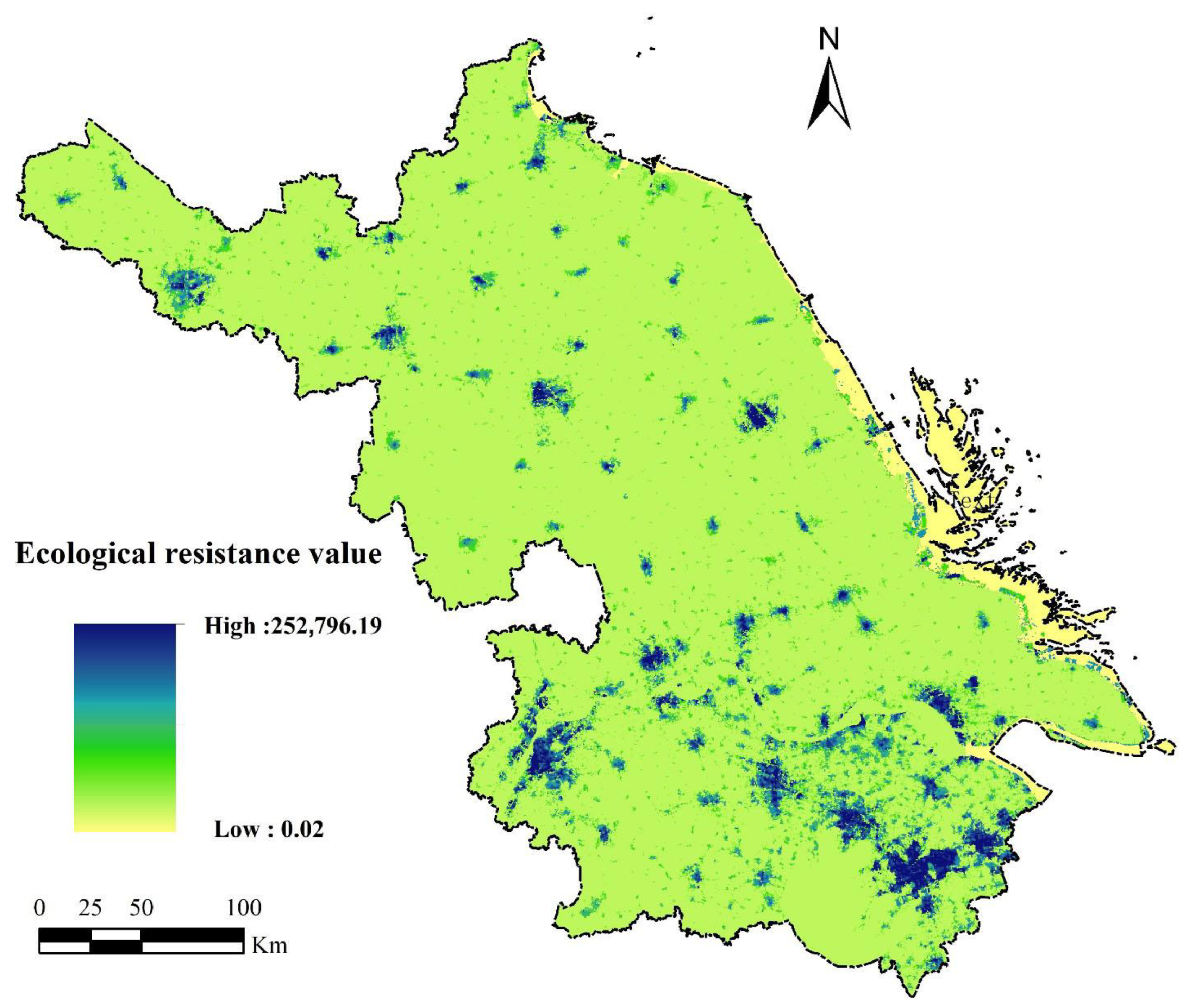
- This study utilises land change survey data for ESP construction, contrasting with prior remote sensing-based approaches [11]. The dataset incorporates 56 land classification categories. We established ecological resistance coefficients for distinct land use types, integrating nighttime light data correction to develop a refined resistance surface. MCR was subsequently applied to identify ecological corridors.
- (3)
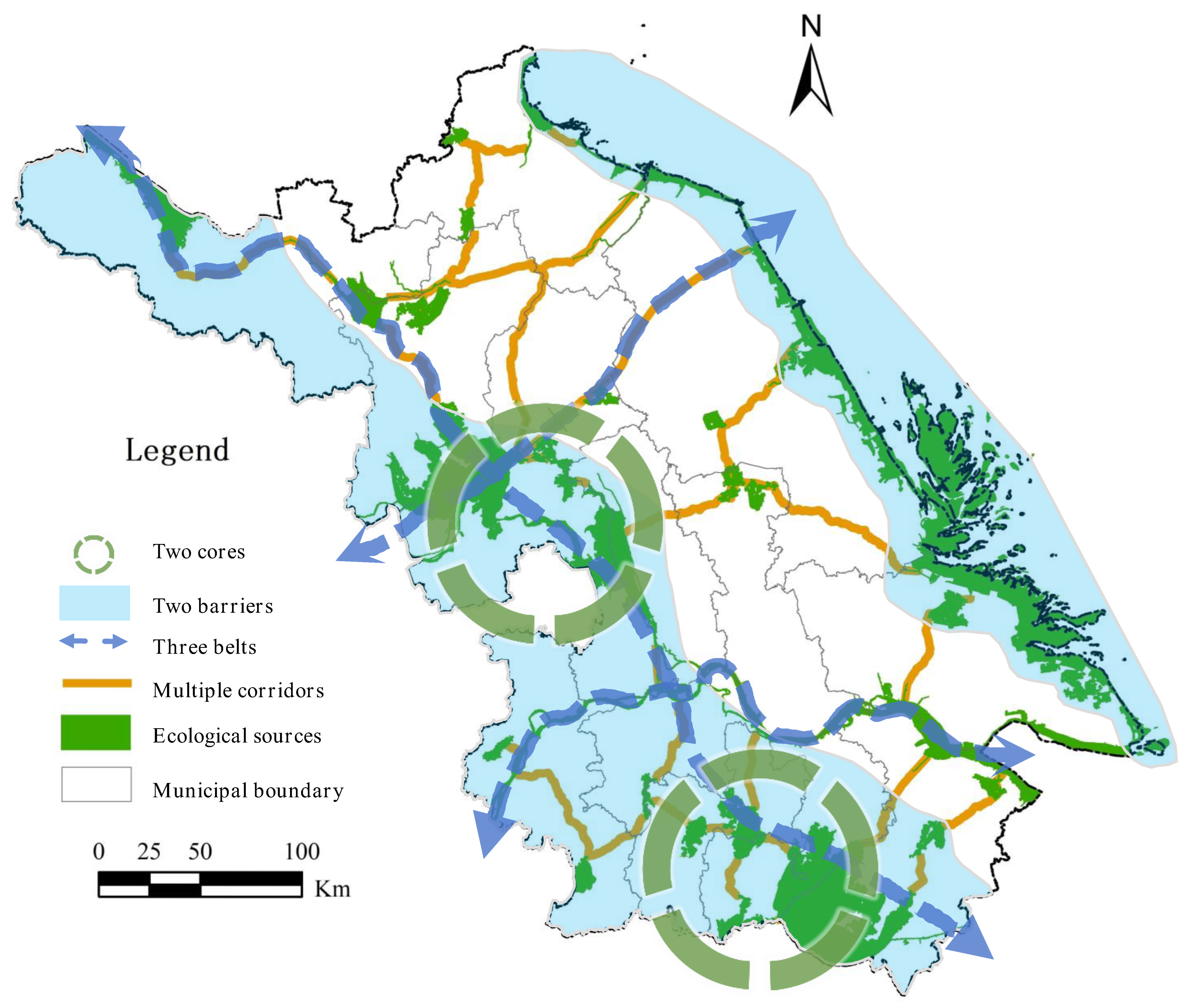
- Empirical research focuses on various scales such as river basins [31,32], cities [33,34], and counties [21,24]. Focusing on Jiangsu Province, an economically advanced yet ecologically pressured region, we construct a provincial-scale ESP described as “Two Cores, Two Barriers, Three Belts, and Multiple Corridors”. This approach provides a replicable basis for regional ecological planning and sustainable governance, particularly in developed areas under high anthropogenic pressure.
2. Materials and Methodology
2.1. Study Area
2.2. Data Sources and Processing
2.3. Methodology
2.3.1. Ecological Source Identification
Evaluating the Ecosystem Services Value
Ecological Sensitivity Assessment
2.3.2. Ecological Resistance Surface Construction
2.3.3. Ecological Corridor Extraction
3. Results
3.1. Characteristics of Ecological Source
3.2. Spatial Distribution of Ecological Resistance Surface
3.3. Spatial Distribution of Ecological Corridor
3.4. ESP of Two Cores, Two Barriers, Three Belts, and Multiple Corridors
- (1)
- Two Cores refer to the ecological cores containing key ecological sources: the Taihu Hilly Ecological Green Core and the Jianghuai Lake Complex Ecological Green Core. The Taihu Hilly Ecological Green Core encompasses Taihu Lake and the administrative regions of Gaochun District (Nanjing), Yixing City (Wuxi), as well as Jintan District and Liyang City (Changzhou). The Jianghuai Lake Complex Ecological Green Core comprises lake groups in central Jiangsu such as Hongze Lake and Gaoyou Lake, spanning Hongze District, Xuyi County, and Jinhu County (Huai’an); Sihong County and Siyang County (Suqian); Gaoyou City and Baoying County (Yangzhou); and Xinghua City (Taizhou).
- (2)
- Two Barriers denote the Coastal Ecological Barrier and the Western Hilly Ecological Barrier. The Coastal Ecological Barrier consists of Jiangsu’s extensive nearshore waters and coastal zones, incorporating typical marine ecosystems like coastal wetlands, estuaries, and bays. The Western Hilly Ecological Barrier refers to the Jianghuai Hills, Ningzhen Mountains, Yili Mountains, and their surrounding lake areas.
- (3)
- Three Belts represent ecological conservation belts with composite functions including ecological conservation, landscape recreation, and ventilation corridors. These include: (1) the Yangtze River Ecological Conservation Belt, a vital drinking water source area in Jiangsu, crucial for maintaining aquatic migration corridors and protecting biodiversity; (2) the Hongze Lake-Huaihe River Estuary Ecological Conservation Belt, encompassing the water body ecological sources and corridor areas of Hongze Lake, the Huaihe River, and other water bodies; (3) the Grand Canal (Beijing-Hangzhou) Belt, China’s most renowned canal, forming a continuous north-south green ecological conservation corridor traversing Jiangsu.
- (4)
- Multiple Corridors constitute the ecological sources and connecting corridors, primarily comprising cross-regional, river-coastal water system ecological corridors such as the Yangtze River, Huaihe River, Yi-Shu-Si River system, and the Grand Canal. These serve as vital passages for species migration.
4. Discussion
4.1. Response to Research Objectives and Methodological Approach
4.2. Comparative Analysis with Studies in China and Southeast Asia
4.3. Implication for Optimising the ESP
4.4. Limitations and Future Research
5. Conclusions
- (1)
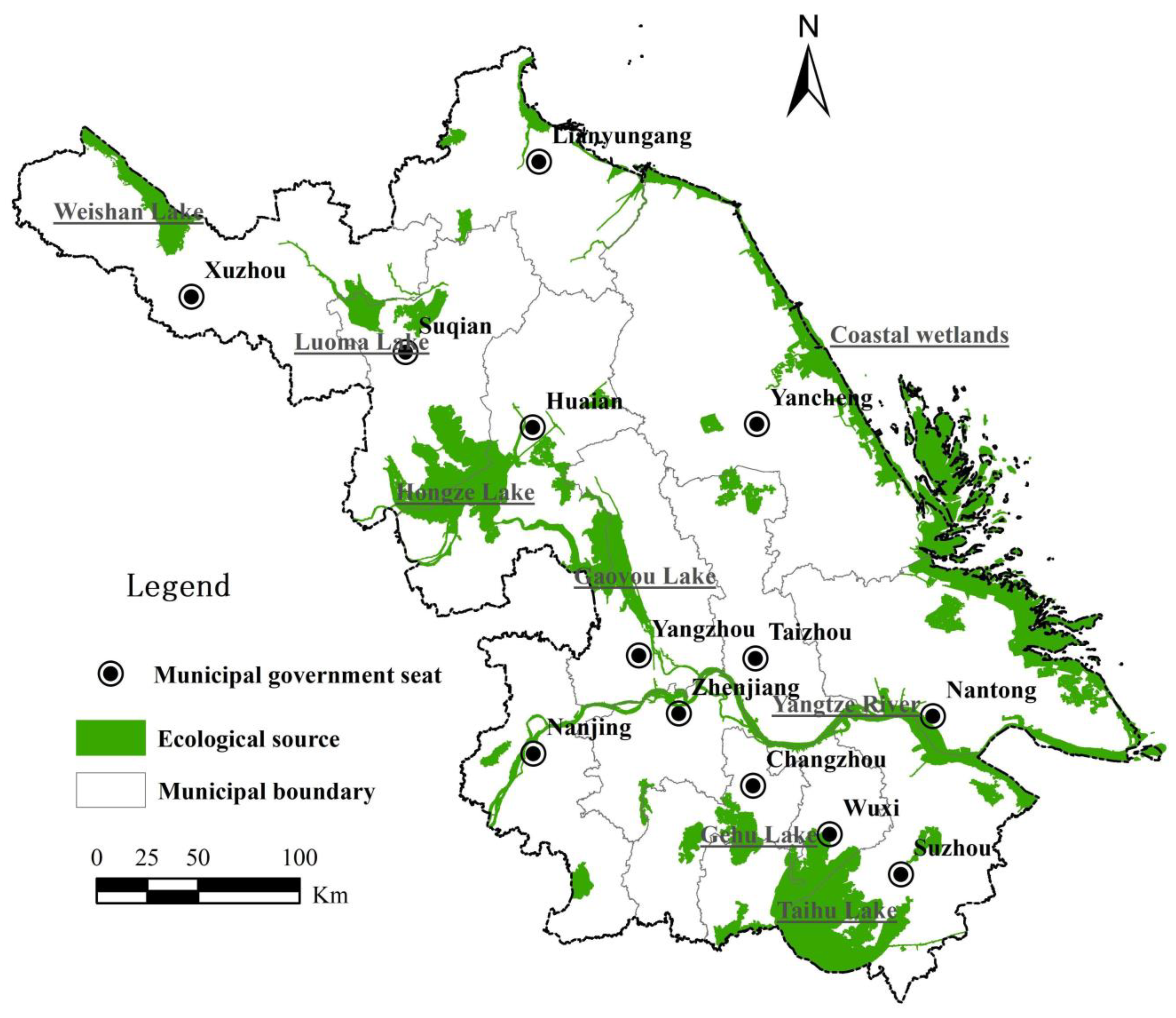
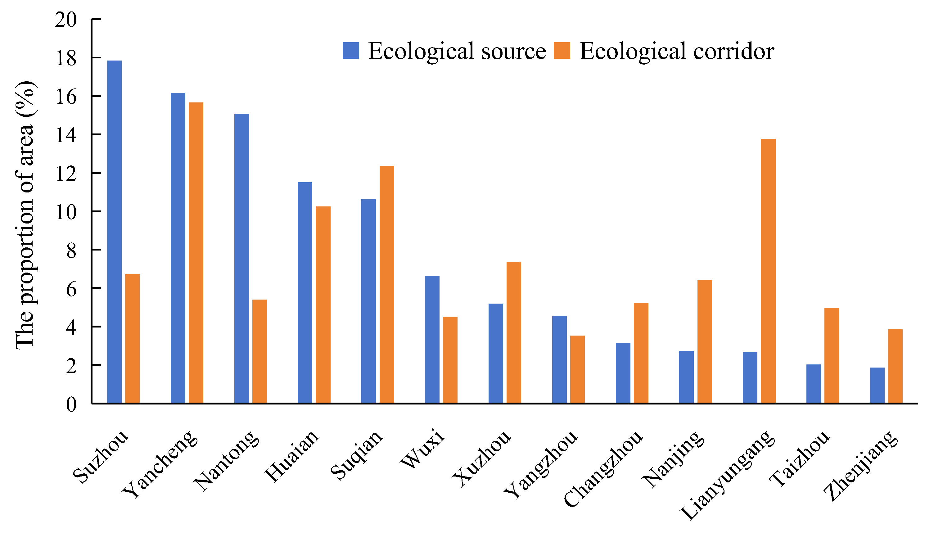
- Jiangsu’s total ecological source area covers 1.46 × 10⁴ km2, representing 13.71% of the province. These sources concentrate in eastern coastal mudflats (3274.30 km2) across Yancheng, Nantong, and Lianyungang; major lakes including Taihu, Hongze, Gaoyou, and Luoma; and woodland patches in southwestern Jiangsu. Water bodies constitute 59.90% of ecological source landscapes.
- (2)
- The province’s ecological corridors span 1934.16 km. They structurally connect northern, central, and southern Jiangsu. The densest connectivity occurs among Suqian and Lianyungang (north), Huai’an and Yancheng (centre), and Yangzhou and Wuxi (south). Cultivated land dominates corridor landscapes at 38.56%.
- (3)
- An ESP of “Two Cores, Two Barriers, Three Belts, Multiple Corridors” was established, with targeted optimisation policy recommendations proposed.
Author Contributions
Funding
Data Availability Statement
Conflicts of Interest
References
- Yu, K.J. Security patterns and surface model in landscape ecological planning. Landsc. Urban Plan. 1996, 36, 1–17. [Google Scholar] [CrossRef]
- Wang, Y.; Pan, J.H. Building ecological security patterns based on ecosystem services value reconstruction in an arid inland basin: A case study in Ganzhou District, NW China. J. Clean. Prod. 2019, 241, 118337. [Google Scholar] [CrossRef]
- Gou, M.M.; Li, L.; Ouyang, S.; Shu, C.; Xiao, W.F.; Wang, N.; Hu, J.W.; Liu, C.F. Integrating ecosystem service trade-offs and rocky desertification into ecological security pattern construction in the Daning river basin of southwest China. Ecol. Indic. 2022, 138, 108845. [Google Scholar] [CrossRef]
- Meng, H.; Liu, Q.M.; Yang, J.; Li, J.B.; Chuai, X.; Huang, X.J. Spatial Interaction and Driving Factors between Urban Land Expansion and Population Change in China. Land 2024, 13, 1295. [Google Scholar] [CrossRef]
- Li, L.; Huang, X.J.; Wu, D.F.; Yang, H. Construction of ecological security pattern adapting to future land use change in Pearl River Delta, China. Appl. Geogr. 2023, 154, 102946. [Google Scholar] [CrossRef]
- Fu, B.J.; Liu, Y.X.; Zhao, W.W.; Wu, J.G. The emerging “pattern-process-service-sustainability” paradigm in landscape ecology. Landsc. Ecol. 2025, 40, 54. [Google Scholar] [CrossRef]
- Klar, N.; Herrmann, M.; Henning-Hahn, M.; Pott-Dörfer, B.; Hofer, H.; Kramer-Schadt, S. Between ecological theory and planning practice: (Re-) Connecting forest patches for the wildcat in Lower Saxony, Germany. Landsc. Urban Plan. 2012, 105, 376–384. [Google Scholar] [CrossRef]
- Li, L.; Huang, X.J.; Wu, D.F.; Wang, Z.L.; Yang, H. Optimization of ecological security patterns considering both natural and social disturbances in China’s largest urban agglomeration. Ecol. Eng. 2022, 180, 106647. [Google Scholar] [CrossRef]
- Xie, H.L.; He, Y.F.; Choi, Y.; Chen, Q.R.; Cheng, H. Warning of negative effects of land-use changes on ecological security based on GIS. Sci. Total Environ. 2020, 704, 135427. [Google Scholar] [CrossRef]
- Lai, J.L.; Qi, S. Construction of ecological security pattern based on ecological protection red line, machine learning algorithms, and circuit theory: A case study of Kunming city, China. J. Clean. Prod. 2025, 520, 146117. [Google Scholar] [CrossRef]
- Pan, J.H.; Liang, J.; Zhao, C.C. Identification and optimization of ecological security pattern in arid inland basin based on ordered weighted average and ant colony algorithm: A case study of Shule River basin, NW China. Ecol. Indic. 2023, 154, 110588. [Google Scholar] [CrossRef]
- Dai, L.; Liu, Y.B.; Luo, X.Y. Integrating the MCR and DOI models to construct an ecological security network for the urban agglomeration around Poyang Lake, China. Sci. Total Environ. 2021, 754, 141868. [Google Scholar] [CrossRef]
- Pierik, M.E.; Dell’Acqua, M.; Confalonieri, R.; Bocchi, S.; Gomarasca, S. Designing ecological corridors in a fragmented landscape: A fuzzy approach to circuit connectivity analysis. Ecol. Indic. 2016, 67, 807–820. [Google Scholar] [CrossRef]
- Li, S.C.; Xiao, W.; Zhao, Y.L.; Lv, X.J. Incorporating ecological risk index in the multi-process MCRE model to optimize the ecological security pattern in a semi-arid area with intensive coal mining: A case study in northern China. J. Clean. Prod. 2020, 247, 119143. [Google Scholar] [CrossRef]
- Zhang, Y.L.; Zhao, Z.Y.; Yang, Y.Y.; Fu, B.J.; Ma, R.M.; Lü, Y.H.; Wu, X. Identifying ecological security patterns based on the supply, demand and sensitivity of ecosystem service: A case study in the Yellow River Basin, China. J. Environ. Manag. 2022, 315, 115158. [Google Scholar] [CrossRef] [PubMed]
- Jia, Q.Q.; Jiao, L.M.; Lian, X.H.; Wang, W.L. Linking supply-demand balance of ecosystem services to identify ecological security patterns in urban agglomerations. Sustain. Cities Soc. 2023, 92, 104497. [Google Scholar] [CrossRef]
- Wang, J.X.; Lai, X.W.; Zhang, Z.F.; Zhou, S.L.; Lv, L.G.; Fan, Y.T. Optimization of territorial ecological space under the constraint of ecosystem service externalities. Ecol. Indic. 2024, 168, 112752. [Google Scholar] [CrossRef]
- Meier, K.; Kuusemets, V.; Luig, J.; Mander, Ü. Riparian buffer zones as elements of ecological networks: Case study on Parnassius mnemosyne distribution in Estonia. Ecol. Eng. 2005, 24, 531–537. [Google Scholar] [CrossRef]
- Liang, K.Y.; Jin, X.J.; Zhang, X.L.; Song, J.P.; Li, Q.Q.; Ying, S.C.; Qi, Z.; Zhou, Y.K. Construction of ecological security patterns coupling supply and demand of ecosystem services: A case study of Southern Jiangsu Province. Acta Ecol. Sin. 2024, 44, 3880–3896. [Google Scholar] [CrossRef]
- Jalkanen, J.; Toivonen, T.; Moilanen, A. Identification of ecological networks for land-use planning with spatial conservation prioritization. Landsc. Ecol. 2020, 35, 353–371. [Google Scholar] [CrossRef]
- Nie, W.B.; Shi, Y.; Siaw, M.J.; Yang, F.; Wu, R.W.; Wu, X.; Zheng, X.Y.; Bao, Z.Y. Constructing and optimizing ecological network at county and town Scale: The case of Anji County, China. Ecol. Indic. 2021, 132, 108294. [Google Scholar] [CrossRef]
- Liang, J.; He, X.Y.; Zeng, G.M.; Zhong, M.H.; Gao, X.; Li, X.; Li, X.D.; Wu, H.P.; Feng, C.T.; Xing, W.L.; et al. Integrating priority areas and ecological corridors into national network for conservation planning in China. Sci. Total Environ. 2018, 626, 22–29. [Google Scholar] [CrossRef]
- Gobeyn, S.; Mouton, A.M.; Cord, A.F.; Kaim, A.; Volk, M.; Goethals, P.L.M. Evolutionary algorithms for species distribution modelling: A review in the context of machine learning. Ecol. Model. 2019, 392, 179–195. [Google Scholar] [CrossRef]
- Zhang, T.Y.; Chen, W.B.; Sheng, Z.Y.; Wang, P.Q.; Guan, F.Y. Ecological network construction and identification of important elements based on morphological spatial pattern analysis and circuit theory in Pingxiang City. J. Nat. Conserv. 2025, 86, 126902. [Google Scholar] [CrossRef]
- Lin, J.; Wang, Y.; Lin, Z.; Li, S. National-scale connectivity analysis and construction of forest networks based on graph theory: A case study of China. Ecol. Eng. 2025, 216, 107639. [Google Scholar] [CrossRef]
- Wang, Y.X.; Qiao, J.M.; Hu, Y.M.; Zhang, Q.; Han, X.L.; Li, C.L. Risk Assessment of Non-Point Source Pollution Based on the Minimum Cumulative Resistance Model: A Case Study of Shenyang, China. Land 2025, 14, 88. [Google Scholar] [CrossRef]
- Knaapen, J.P.; Scheffer, M.; Harms, B. Estimating Habitat Isolation in Landscape Planning. Landsc. Urban Plan. 1992, 23, 1–16. [Google Scholar] [CrossRef]
- Chen, Z.F.; Liu, Y.S.; Feng, W.L.; Li, Y.R.; Li, L.N. Study on spatial tropism distribution of rural settlements in the Loess Hilly and Gully Region based on natural factors and traffic accessibility. J. Rural Stud. 2022, 93, 441–448. [Google Scholar] [CrossRef]
- Wang, S.; Wu, M.Q.; Hu, M.M.; Fan, C.; Wang, T.; Xia, B.C. Promoting landscape connectivity of highly urbanized area: An ecological network approach. Ecol. Indic. 2021, 125, 107487. [Google Scholar] [CrossRef]
- Xiao, S.C.; Wu, W.J.; Guo, J.; Ou, M.H.; Pueppke, S.G.; Ou, W.X.; Tao, Y. An evaluation framework for designing ecological security patterns and prioritizing ecological corridors: Application in Jiangsu Province, China. Landsc. Ecol. 2020, 35, 2517–2534. [Google Scholar] [CrossRef]
- Huang, Y.; Huang, J.L.; Liao, T.J.; Liang, X.; Tian, H. Simulating urban expansion and its impact on functional connectivity in the Three Gorges Reservoir Area. Sci. Total Environ. 2018, 643, 1553–1561. [Google Scholar] [CrossRef]
- Wei, C.Z.; Taubenböck, H.; Blaschke, T. Measuring urban agglomeration using a city-scale dasymetric population map: A study in the Pearl River Delta, China. Habitat Int. 2017, 59, 32–43. [Google Scholar] [CrossRef]
- Li, F.; Ye, Y.P.; Song, B.W.; Wang, R.S. Evaluation of urban suitable ecological land based on the minimum cumulative resistance model: A case study from Changzhou, China. Ecol. Model. 2015, 318, 194–203. [Google Scholar] [CrossRef]
- Hu, X.J.; Ma, C.M.; Huang, P.; Guo, X. Ecological vulnerability assessment based on AHP-PSR method and analysis of its single parameter sensitivity and spatial autocorrelation for ecological protection ? A case of Weifang City, China. Ecol. Indic. 2021, 125, 107464. [Google Scholar] [CrossRef]
- Meng, H.; Huang, X.J.; Yang, H.; Chen, Z.G.; Yang, J.; Zhou, Y.; Li, J.B. The influence of local officials’ promotion incentives on carbon emission in Yangtze River Delta, China. J. Clean. Prod. 2019, 213, 1337–1345. [Google Scholar] [CrossRef]
- Sun, X.L.; Peng, B.H.; Elahi, E.; Wan, A.X. Examining the evolution and influential factors of regional ecological security patterns: A case study of Jiangsu Province, China. Stoch. Environ. Res. Risk Assess. 2025, 39, 999–1013. [Google Scholar] [CrossRef]
- Costanza, R.; de Groot, R.; Sutton, P.; van der Ploeg, S.; Anderson, S.J.; Kubiszewski, I.; Farber, S.; Turner, R.K. Changes in the global value of ecosystem services. Glob. Environ. Chang. 2014, 26, 152–158. [Google Scholar] [CrossRef]
- Hasan, S.S.; Zhen, L.; Miah, M.G.; Ahamed, T.; Samie, A. Impact of land use change on ecosystem services: A review. Environ. Dev. 2020, 34, 100527. [Google Scholar] [CrossRef]
- Xie, G.D.; Zhang, C.X.; Zhang, L.M.; Chen, W.H.; Li, S.M. Improvement of the Evaluation Method for Ecosystem Service Value Based on Per Unit Area. J. Nat. Resour. 2015, 30, 1243–1254. [Google Scholar] [CrossRef]
- Xu, L.F.; Xu, X.G.; Luo, T.; Zhu, G.R.; Ma, Z.W. Services based on land use:A case study of Bohai Rim. Geogr. Res. 2012, 31, 1775–1784. (In Chinese) [Google Scholar]
- GB/T 21010-2017; Current Land Use Classification. China National Standardization Administration: Beijing, China, 2017.
- Ust, Y.; Sogut, O.S.; Sahin, B.; Durmayaz, A. Ecological coefficient of performance (ECOP) optimization for an irreversible Brayton heat engine with variable-temperature thermal reservoirs. J. Energy Inst. 2006, 79, 47–52. [Google Scholar] [CrossRef]
- Li, Y.Y.; Wei, M.; Zhou, R.; Jin, H.; Chen, Y.S.; Hong, C.J.; Duan, W.T.; Li, Q.Y. Identifying priority restoration areas based on ecological security pattern: Implications for ecological restoration planning. Ecol. Indic. 2025, 174, 113486. [Google Scholar] [CrossRef]
- Fanhua, K.; Haiwei, Y.; Nakagoshi, N.; Yueguang, Z. Urban green space network development for biodiversity conservation: Identification based on graph theory and gravity modeling. Landsc. Urban Plan. 2010, 95, 16–27. [Google Scholar] [CrossRef]
- Liu, Z.; Wang, Y.; Li, Z.; Peng, J. Impervious surface impact on water quality in the process of rapid urbanization in Shenzhen, China. Environ. Earth Sci. 2013, 68, 2365–2373. [Google Scholar] [CrossRef]
- Peng, J.; Pan, Y.J.; Liu, Y.X.; Zhao, H.J.; Wang, Y.L. Linking ecological degradation risk to identify ecological security patterns in a rapidly urbanizing landscape. Habitat Int. 2018, 71, 110–124. [Google Scholar] [CrossRef]
- Wei, Q.Q.; Abudureheman, M.; Halike, A.; Yao, K.X.; Yao, L.; Tang, H.; Tuheti, B. Temporal and spatial variation analysis of habitat quality on the PLUS-InVEST model for Ebinur Lake Basin, China. Ecol. Indic. 2022, 145, 109632. [Google Scholar] [CrossRef]
- Ribeiro, J.W.; Silveira dos Santos, J.; Dodonov, P.; Martello, F.; Brandão Niebuhr, B.; Ribeiro, M.C. LandScape Corridors (lscorridors): A new software package for modelling ecological corridors based on landscape patterns and species requirements. Methods Ecol. Evol. 2017, 8, 1425–1432. [Google Scholar] [CrossRef]
- Li, S.N.; Zhu, C.M.; Lin, Y.; Dong, B.Y.; Chen, B.J.; Si, B.; Li, Y.J.; Deng, X.D.; Gan, M.Y.; Zhang, J.; et al. Conflicts between agricultural and ecological functions and their driving mechanisms in agroforestry ecotone areas from the perspective of land use functions. J. Clean. Prod. 2021, 317, 128453. [Google Scholar] [CrossRef]
- Liang, Y.; Jiao, J.; Tang, B.; Cao, B.; Li, H. Response of runoff and soil erosion to erosive rainstorm events and vegetation restoration on abandoned slope farmland in the Loess Plateau region, China. J. Hydrol. 2020, 584, 124694. [Google Scholar] [CrossRef]
- Shen, J.K.; Wang, Y.C. An improved method for the identification and setting of ecological corridors in urbanized areas. Urban Ecosyst. 2023, 26, 141–160. [Google Scholar] [CrossRef]
- Ersoy, E.; Jorgensen, A.; Warren, P.H. Identifying multispecies connectivity corridors and the spatial pattern of the landscape. Urban For. Urban Green. 2019, 40, 308–322. [Google Scholar] [CrossRef]
- Loro, M.; Ortega, E.; Arce, R.M.; Geneletti, D. Ecological connectivity analysis to reduce the barrier effect of roads. An innovative graph-theory approach to define wildlife corridors with multiple paths and without bottlenecks. Landsc. Urban Plan. 2015, 139, 149–162. [Google Scholar] [CrossRef]
- Zhou, Y.; Feng, Z.; Lin, Q.; Wang, J.B.; Zhang, K.X.; Wu, K.N. Research progress on the width of ecological corridors in ecological security paltem. Chin. J. Appl. Ecol. 2025, 36, 918–926. [Google Scholar]
- Ghosh, A.; Maiti, R. Development of new Ecological Susceptibility Index (ESI) for monitoring ecological risk of river corridor using F-AHP and AHP and its application on the Mayurakshi river of Eastern India. Ecol. Inform. 2021, 63, 101318. [Google Scholar] [CrossRef]
- Fu, Y.J.; Shi, X.Y.; He, J.; Yuan, Y.; Qu, L.L. Identification and optimization strategy of county ecological security pattern: A case study in the Loess Plateau, China. Ecol. Indic. 2020, 112, 106030. [Google Scholar] [CrossRef]
- Jiangsu Provincial People’s Government. Jiangsu Provincial Territorial Spatial Planning (2021–2035). Available online: https://zrzy.jiangsu.gov.cn/gtxxgk/nrglIndex.action?type=2&messageID=2c9082548b6e0094018b6fda45ab00b9 (accessed on 3 September 2024).
- Ma, X.P.; Li, J.; Yu, Y.Y.; Xu, X.T. Water Ecological Security Pattern Based on Hydrological Regulation Service: A Case Study of the Upper Hanjiang River. Sustainability 2024, 16, 7913. [Google Scholar] [CrossRef]
- Zou, Y.; Wang, S.Q.; Luo, X.; Jin, H.Y.; Xiao, X.; Li, Y.A. A new multivariate index for ecological security assessment in the China-Myanmar border region. J. Environ. Manag. 2024, 364, 121447. [Google Scholar] [CrossRef] [PubMed]
- Zhang, O.S.; Li, F.X.; Wang, D.W.; Li, M.C.; Chen, D. Analysis on changes of ecological spatial connectivity in Jiangsu Province based on ecological network. Acta Eeologica Sin. 2021, 41, 3007–3020. (In Chinese) [Google Scholar]


| Data | Sources | Time | Spatial Resolution |
|---|---|---|---|
| The land change survey data | Jiangsu Provincial Department of Natural Resources | 2015, 2020 | 30 m |
| Soil pollution | Jiangsu Provincial Department of Natural Resources | 2019 | 1 km |
| Water quality | Jiangsu Provincial Department of Natural Resources | 2020 | 1 km |
| Digital elevation model (DEM) | United States Geological Survey | 2000 | 30 m |
| Nighttime light data | https://www.gisrs.cn (accessed on 1 January 2024) | 2020 | 30 m |
| Road space distribution data | https://www.resdc.cn (accessed on 1 October 2023) | 2020 | Vector |
| Soil erosion | https://www.gisrs.cn (accessed on 1 August 2023) | 2020 | 30 m |
| Amount of precipitation | https://www.gisrs.cn (accessed on 1 October 2023) | 2020 | 30 m |
| Normalized difference vegetation index (NDVI) | https://www.gisrs.cn (accessed on 1 August 2022) | 2020 | 30 m |
| Concentration of CO2 emissions | https://www.gisrs.cn (accessed on 1 October 2023) | 2020 | 30 m |
| PM2.5 concentration | https://www.geodata.cn/main/ (accessed on 1 June 2023) | 2020 | 30 m |
| Ecosystem Service | Forest Land | Grassland | Farmland | Wetland | Water Body | Bare Land |
|---|---|---|---|---|---|---|
| Atmospheric regulation | 781.28 | 178.58 | 111.60 | 401.79 | 0.00 | 0.00 |
| Climate regulation | 602.70 | 200.91 | 198.66 | 3817.06 | 102.67 | 0.00 |
| Water harvest | 714.30 | 178.58 | 133.93 | 3459.92 | 4549.22 | 6.69 |
| Soil formation and protection | 870.56 | 435.29 | 325.91 | 381.71 | 2.22 | 4.47 |
| Waste disposal | 292.43 | 292.43 | 366.09 | 4058.15 | 4058.15 | 2.22 |
| Biodiversity Conservation | 727.69 | 243.31 | 158.48 | 558.07 | 555.82 | 75.88 |
| Food production | 22.33 | 66.98 | 223.23 | 66.98 | 22.33 | 2.22 |
| Raw material production | 580.37 | 11.15 | 22.33 | 15.62 | 2.22 | 0.00 |
| Entertainment and Culture | 285.72 | 8.93 | 2.22 | 1238.87 | 993.99 | 2.22 |
| Total | 4877.37 | 1616.16 | 1542.45 | 13,998.15 | 10,286.62 | 93.69 |
| Ecological System | Primary Category of Land Classification | Secondary Category of Land Classification | Land Classification Code |
|---|---|---|---|
| Forest land | Orchard | Fruit Orchard | 0201 |
| Woodland | Arbor Woodland | 0301 | |
| Bamboo Woodland | 0302 | ||
| Shrubland | 0305 | ||
| Other Woodland | 0307 | ||
| Grassland | Grassland | Natural Grassland | 0401 |
| Artificial Grassland | 0403 | ||
| Other Grassland | 0404 | ||
| Land for Public Administration and Public Services | Parks and Green Spaces | 0810 | |
| Farmland | Cropland | Paddy Field | 0101 |
| Irrigated Cropland | 0102 | ||
| Dry Cropland | 0103 | ||
| Orchard | Tea Plantation | 0202 | |
| Rubber Plantation | 0203 | ||
| Other Plantations | 0204 | ||
| Wetland | Wetland | Mangrove Forest | 0303 |
| Forested Wetland | 0304 | ||
| Shrub Wetland | 0306 | ||
| Marsh Grassland | 0402 | ||
| Coastal Tidal Flat | 1105 | ||
| Inland Tidal Flat | 1106 | ||
| Marshland | 1108 | ||
| Water body | Water body | River Surface Water | 1101 |
| Lake Surface Water | 1102 | ||
| Reservoir Water | 1103 | ||
| Pond Water | 1104 | ||
| Canals | 1107 | ||
| Glaciers and Perpetual Snow | 1110 | ||
| Bare land | Bare land | Saline-Alkali Land | 1204 |
| Sandy Land | 1205 | ||
| Bare Soil | 1206 | ||
| Exposed Rock and Gravel | 1207 | ||
| Field Ridges | 1203 |
| Target Layer | Criterion Layer | Definition and Calculation Methodology |
|---|---|---|
| Water bodies Pollution | Water bodies Degradation Ratio | Annual mean rate of waterbody reduction (2015–2020) |
| Proportion of Polluted water bodies | Proportion of polluted water bodies to total area | |
| Soil Environment Degradation | Proportion of Total Polluted Soil Area | Proportion of Polluted Soil Area to Total Area |
| Soil Erosion | Soil Erosion Assessment Using the Soil Loss Equation Model, , R: Rainfall erosivity (MJ·mm·ha−1·h−1·yr−1), s: Slope gradient (dimensionless), e: Elevation factor (m), v: Vegetation cover index (NDVI, dimensionless) | |
| Atmospheric Pollution | Atmospheric CO2 Concentration | Anthropogenic Atmospheric Pollution Level |
| Ambient PM2.5 Concentration | Quantified using satellite-derived atmospheric aerosol optical depth—a parameter significantly positively correlated with PM2.5 | |
| Ecological Land Degradation | Forest Land Degradation Ratio | Annual mean rate of forest land reduction (2015–2020) |
| Vegetation Coverage Rate | Normalised difference vegetation index (NDVI)—a radiometric measure indicating relative abundance and vigour of green vegetation | |
| Construction Land Stress | Road Density | Road area per unit grid area. Higher values denote greater landscape fragmentation and elevated ecological sensitivity |
| Land Development Intensity | Proportion of regional construction land to total area |
Disclaimer/Publisher’s Note: The statements, opinions and data contained in all publications are solely those of the individual author(s) and contributor(s) and not of MDPI and/or the editor(s). MDPI and/or the editor(s) disclaim responsibility for any injury to people or property resulting from any ideas, methods, instructions or products referred to in the content. |
© 2025 by the authors. Licensee MDPI, Basel, Switzerland. This article is an open access article distributed under the terms and conditions of the Creative Commons Attribution (CC BY) license (https://creativecommons.org/licenses/by/4.0/).
Share and Cite
Meng, H.; Gong, Z.; Qian, C.; Zhao, X.; Liu, Q.; Bu, X.; Shen, C. Deciphering the Spatial Code: Identification and Optimization of Ecological Security Pattern—A Case Study of Jiangsu Province, China. Land 2025, 14, 1928. https://doi.org/10.3390/land14091928
Meng H, Gong Z, Qian C, Zhao X, Liu Q, Bu X, Shen C. Deciphering the Spatial Code: Identification and Optimization of Ecological Security Pattern—A Case Study of Jiangsu Province, China. Land. 2025; 14(9):1928. https://doi.org/10.3390/land14091928
Chicago/Turabian StyleMeng, Hao, Zhoukai Gong, Chang Qian, Xiaofeng Zhao, Qianming Liu, Xinguo Bu, and Chunzhu Shen. 2025. "Deciphering the Spatial Code: Identification and Optimization of Ecological Security Pattern—A Case Study of Jiangsu Province, China" Land 14, no. 9: 1928. https://doi.org/10.3390/land14091928
APA StyleMeng, H., Gong, Z., Qian, C., Zhao, X., Liu, Q., Bu, X., & Shen, C. (2025). Deciphering the Spatial Code: Identification and Optimization of Ecological Security Pattern—A Case Study of Jiangsu Province, China. Land, 14(9), 1928. https://doi.org/10.3390/land14091928


