Article

Spatial Connectivity and Development Potential of Traditional Villages in Clustered Areas: A Case Study of Qiandongnan Prefecture

1
College of Architecture and Urban Planning, Guizhou University, Guiyang 550025, China
2
School of Architecture and Art, Central South University, Changsha 410083, China
3
School of Urban and Rural Planning and Architectural Engineering, Guiyang University, Guiyang 550005, China
*
Author to whom correspondence should be addressed.
Land 2025, 14(10), 1929; https://doi.org/10.3390/land14101929
Submission received: 14 August 2025 / Revised: 18 September 2025 / Accepted: 19 September 2025 / Published: 23 September 2025

Abstract

Traditional villages, as forms of significant cultural heritage, have garnered global scholarly attention. This study focuses on the traditional village clusters in Qiandongnan Prefecture, a UNESCO World Heritage site, which includes 415 nationally designated villages. Based on spatial relational analysis and other methods, this study explores the intrinsic relationship between the spatial connectivity of traditional village clusters and their development. The findings are as follows: 1. The spatial distribution of villages exhibits a “dense core, sparse periphery, and localized jumps” pattern. 2. There are five types of development, with over 70% based on agriculture and low industrial differentiation. 3. The spatial connectivity network is clustered, with overall connectivity but a lack of internal coherence, forming a hierarchical network constrained by geography. 4. The spatial connectivity is relatively unstable, highly vulnerable, and exhibits a clear core-periphery structure, where geographical proximity determines basic connections and functional uniqueness drives value-added connections. 5. The overall development potential of these villages is assessed as medium to low. Enhancing network connectivity can foster comprehensive development, and adjusting spatial connectivity could improve its development potential. The study proposes a two-tiered optimization strategy based on the intrinsic connectivity and development characteristics of these villages, providing insights into the development of traditional villages in other regions and cultural heritage areas worldwide.

1. Introduction

The protection and utilization of historical and cultural heritage has long been a focal point of global academic attention. UNESCO recognizes such heritage as possessing Outstanding Universal Value and advocates for its inclusion in the global cultural heritage protection system. Moreover, analyzing the overall characteristics of heritage clusters and promoting their integrated protection and utilization have become key priorities in the field [1].
Traditional villages have great historical, cultural, scientific, social and economic value, and the analysis of the characteristics of their agglomeration areas and their protection and utilization have long become a topic of international concern [2,3,4]. The protection and utilization of traditional villages have always been part of national policy for China’s development, but their development faces challenges such as an imbalance between measures and their own conditions, separate administrations, regional disharmony, and homogeneous competition. To prevent obstruction and exclusion of optimal resource allocation due to single administrative protection, the Ministry of Housing and Construction initiated the “Traditional Villages Concentrated and Continuous Protection and Utilization Demonstration Project” in 2020. This project emphasizes integrating traditional villages’ resources and enhancing comprehensive benefits under concentrated protection and development. In recent years, the cluster-based development approach of concentrated contiguous regional village groups have been the key point of concern in China, and comprehensively understanding the characteristics and development potential of traditional village groups is fundamental for the sustainable development of regional villages, and the key to the benign development of traditional villages.
Accurately assessing the development-level differences in village clusters in agglomeration areas and conducting integrated planning for them is a complex task. At present, academic research on traditional village development has mainly focused on individual cases, emphasizing cultural protection and inheritance [5,6], landscape [6,7,8,9], self-value [10,11,12], influencing factors [13,14,15], and development model [16,17,18,19]. However, both the domestic and international literature show a notable lack of research adopting a collective or cluster-based perspective. Although there are group studies on historical and cultural heritage in the world, and there are historical and cultural sites with a research sample of more than 100, the research objects are mainly historical sites in towns, such as fortresses and churches [20,21,22,23,24], and there are few historical villages. At the same time, international research on spatial connectivity in the context of cultural heritage has primarily focused on the circulation of tangible and intangible elements within architectural spaces, such as spatial connectivity, accessibility, and public engagement. These aspects are considered crucial for supporting the sustainable development of heritage sites under study [25,26]. A small number of studies on the traditional village clusters in China mainly concentrated on distribution characteristics, cluster unit division, and protection strategies, lacking analysis of interior spatial connectivity, influencing factors, and potential development measurements [27]. This research gap has, to a certain extent, constrained the systematic understanding of traditional village resources and the formulation of coordinated conservation and development strategies, while also impeding the functional reconstruction and vitality recovery of traditional villages against the backdrop of contemporary rural revitalization.
The Qiandongnan Miao and Dong Autonomous Prefecture (hereinafter referred to as Qiandongnan), endowed with abundant natural, ecological, and cultural resources, serves as an ecological source area for major economic zones in China. With 415 national-level traditional villages, it ranks first among prefecture-level regions in China. As a typical cluster area of traditional villages in the country and one of the world’s 18 original ecological cultural conservation circles, Qiandongnan’s traditional village cluster exemplifies a representative and practically grounded case for this study. This research attempts to integrate spatial layout analysis, spatial network modeling, and a development potential evaluation system to systematically characterize the spatial structural features of traditional village clusters, identify key nodes and influencing mechanisms, and propose a hierarchical classification strategy system based on three categories of villages: “development-advantaged,” “development-opportunity,” and “development-general.” This approach contributes to transitioning from “point-based conservation” to “regional coordinated planning,” enhances the collaborative utilization efficiency of traditional village resources, promotes the optimization of spatial structures and functional reconstruction, and provides theoretical references for the clustered conservation and differentiated development of traditional villages in China. The findings of this study can also offer insights that can support research on other traditional village clusters and even global cultural heritage clusters.

2. Methodology

2.1. Case Study Area

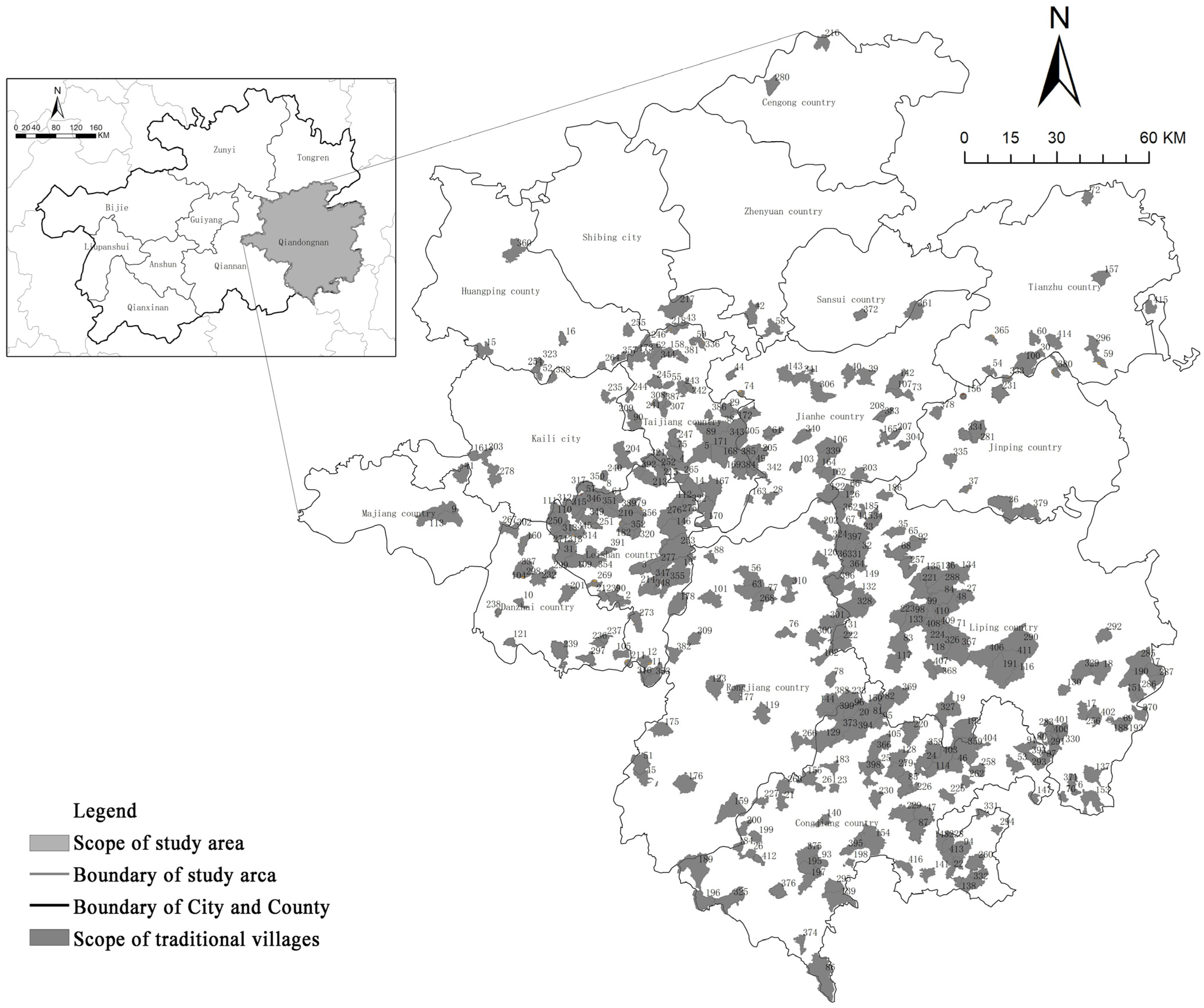
Qiandongnan Miao and Dong Autonomous Prefecture (hereafter referred to as Qiandongnan) is located in the southeastern part of Guizhou Province, China, spanning from 107°17′20″ E to 109°35′24″ E and from 25°19′20″ N to 27°31′40″ N. Situated at the junction of Guizhou, Hunan, and Guangxi provinces, it is a multi-ethnic autonomous region predominantly inhabited by the Miao and Dong ethnic groups. The prefecture is home to 47 ethnic groups, including Miao, Dong, Han, Buyi, Shui, Yao, Zhuang, and Tujia, with ethnic minorities accounting for 81.1% of the registered population. Numerous traditional villages are nestled within the mountainous terrain of the Yunnan-Guizhou Plateau, often characterized by well-established settlement structures and a stable population base [28]. Due to historical and regional reasons, Qiandongnan Prefecture has been in a relatively closed state for a long time, and the original ethnic humanities ecosystem has been relatively intact, and has been listed as one of the 18 ecological and cultural protection circles in the world by the World Native Culture Conservation Foundation, and there are 415 Chinese national traditional villages with natural ecology and original ecological national culture well preserved, which is with obvious natural, ecological and cultural authenticity characteristics (Figure 1 and Figure 2). As early as 2020, Qiandongnan was selected as one of the first demonstration cities for the centralized and contiguous protection and utilization of traditional villages, organized and implemented by the Ministry of Housing and Construction of China. The clustering protection and development of traditional villages in Qiandongnan have a typical and representative nature. However, Qiandongnan Prefecture is an underdeveloped region facing high clustering and homogenization issues in its traditional villages. Therefore, its development should focus on integrating and synergizing resources within the region. In 2020, the added value of the primary, secondary, and tertiary industries in Qiandongnan Prefecture accounted for 20.5%, 21.7%, and 57.8% of the regional GDP, respectively. The industrial structure follows a “three-two-one” pattern, with the tertiary industry contributing the most to GDP growth. The development and utilization of traditional villages are crucial for the steady growth of the tertiary industry [29].

2.2. Research Methods

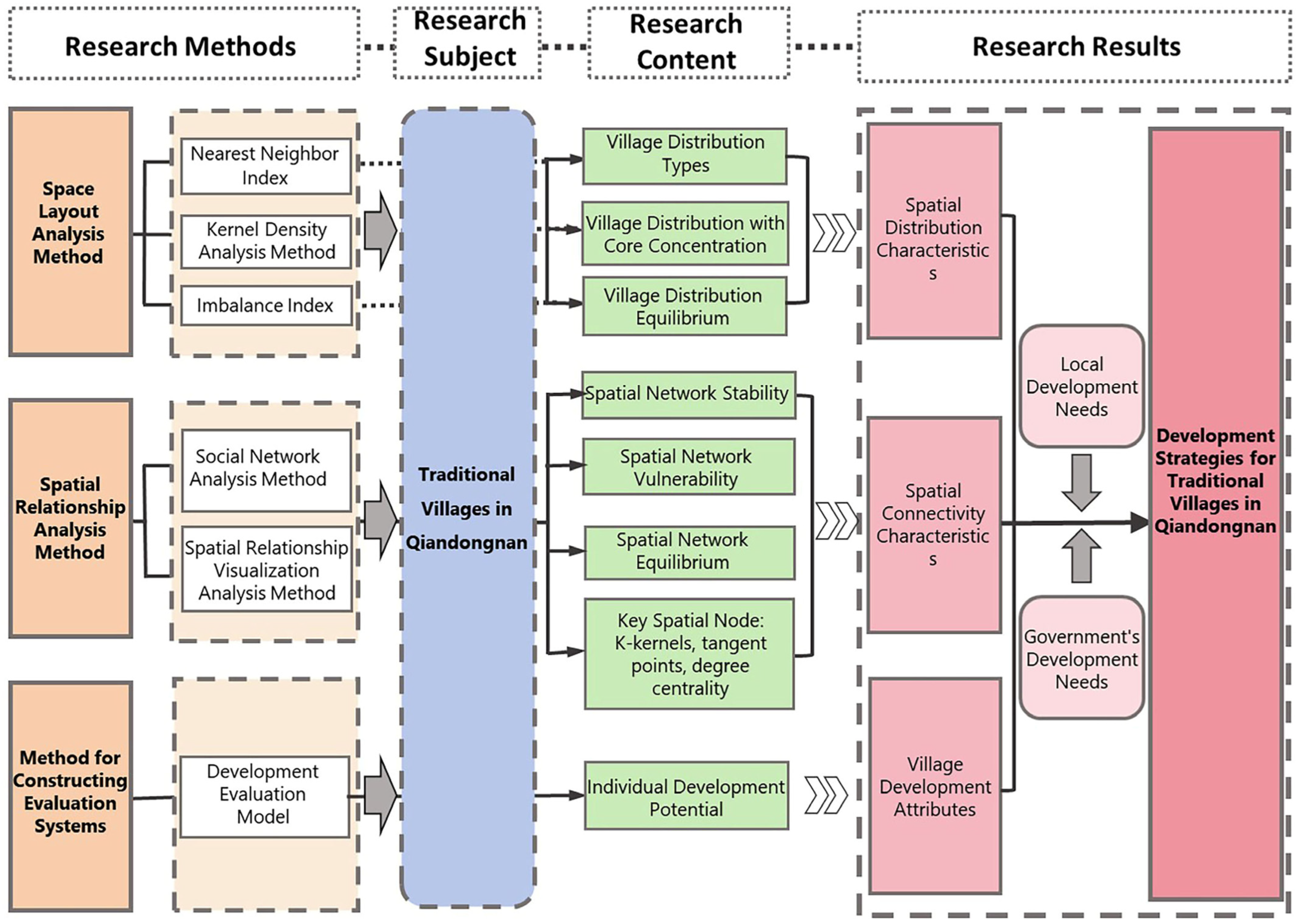
In the study of spatial connectivity and development potential of traditional village clusters in Qiandongnan, spatial layout analysis is employed to examine the distribution types, density patterns, and regional balance of traditional villages. This approach aims to reveal the relationship between historical evolution and human–land patterns, as well as the link between village development types and regional spatial structure. Furthermore, spatial relational analysis is applied to investigate the connectivity network among traditional villages, identifying key nodes and overall structural characteristics within the network. Important nodes or regions are then visualized through spatial mapping techniques to enhance interpretability. Finally, a development potential evaluation system is constructed to assess each village individually. By integrating spatial layout patterns, network connectivity, and village typology, the study proposes a comprehensive protection and development strategy that combines overall spatial coordination with targeted, village-level interventions. As shown in Figure 3.

2.2.1. Spatial Layout Analysis Method

(1)
Kernel Density Analysis Method
Kernel density analysis can calculate the density of point elements or line elements in the surrounding neighborhood through the formula calculation of the discrete distribution of point data in space to generate a continuous surface. This helps to determine the concentration degree and distribution of point data [30]. The larger the kernel density value, the denser the distribution of the research object, and the more obvious the distribution of a certain spatial feature of the research object. The formula for kernel density is as follows [31]:
f ( x , y ) = 1 n λ 2 i = 1 n k / ( d i n )
In Equation (1), n represents the number of samples; λ denotes the bandwidth; k stands for the kernel function; d signifies the spatial distance to sample i ; and f ( x , y ) indicates the kernel density estimation value of the coordinate point ( x , y ) . ArcGIS is employed to transfer the pertinent research findings of traditional villages into their attribute tables, and kernel density mapping is performed based on each dimension to illustrate the spatial distribution of each element of traditional villages.
(2)
Nearest Neighbor Index
Generally, there are three types of spatial distribution of point elements: agglomeration, random, and uniform. The nearest neighbor point index can effectively reflect the spatial point layout attributes, and its formula is as follows [32].
R = 1 n · i = 1 n r i / 1 2 n l s
In Equation (2),   R represents the nearest point index; ri stands for the distance between the traditional village of i and its nearest point; n denotes the number of point elements; and s indicates the area of the study area. When the nearest neighbor index R   >   1 , the point elements tend to be uniformly distributed; when R   =   1 , the point elements are completely randomly distributed; when R   <   1 , the point elements tend to be clustered.
(3)
Imbalance Index
The imbalance index S can be used to measure the equilibrium of the spatial distribution of traditional villages in each county, and it takes a value between 0 and 1. A value of S = 0 indicates that the distribution of traditional villages is uniform and consistent in each county, while a value of S = 1 indicates that traditional villages are concentrated in one county [33].

2.2.2. Spatial Relationship Analysis

Social Network Analysis Method
This study employs social network analysis to transform the complex spatial relationships among traditional villages into spatial topological relationships [34], represented as a spatial network comprising “points” and “lines.” In this context, “points” refer to traditional villages, while “lines” denote the interrelationships or interactions between them [35]. The study converts the traditional villages and the road systems within the study area, along with their connectivity, into nodes and edges of a network. By integrating field surveys, traditional villages that are accessible within a one-hour drive and a six-hour walk are designated as reachable within the specified travel time frame, indicating a steady flow of people and goods between these two points. This establishes a relationship between them, which is recorded as 1 in the relationship matrix; conversely, a lack of relationship is recorded as 0. Ultimately, a relationship matrix is generated, and the spatial relational structure of traditional villages is described in network form.
(1)
Stability
Network stability is assessed by K-kernels, which are defined as the points in the subgraph that are adjacent to at least k other points within the same subgraph. The k-nucleus (where k = 1, 2, 3, …) is utilized to evaluate the local stability of the network. In this study, the stability of the network is determined by the proportion of high K-numbers, and it is considered to be robust if this proportion exceeds half of the average value of K-kernels.
(2)
Vulnerability
In this study, the vulnerability of the network is characterized by “tangent points”. The concept of “tangent points” is derived from the notion of “structural holes” in network analysis, referring to specific nodes within a network that, if removed, would cause the entire network to fragment into multiple independent components. In this study, the vulnerability of the network is measured by the proportion of tangent points present; a higher number of tangent points indicates a greater reliance on individual nodes, thereby increasing the network’s vulnerability.
(3)
Balance
The degree centrality of the network is analyzed by degree centrality potential, which can assess the overall balance of relationships within the network structure. A higher degree of central potential indicates a more significant concentration of relationships among urban construction land, while the equilibrium of the network is lower. The calculation formula is as follows:
C = i = 1 n C m a x C i m a x i = 1 n C m a x C i
In Equation (3), C m a x is the maximum value of the degree centrality of each node in the network, and C i is the centrality of node i .
(4)
Point Degree Centrality
Point degree centrality refers to the core position of a research object within a social network. It indicates the number of connections that the object has with other points in the network. A higher degree centrality signifies a greater number of related connection points, which reflects a higher level of network centrality.
Spatial Relationship Visualization Analysis Method
Utilizing Geographic Information Systems (GIS) for spatial node localization transforms the social network relationships of traditional villages into spatial relationships based on geographic locations, thereby facilitating visual analysis.

2.2.3. Method for Constructing Evaluation Systems

For the main influencing factors of the development of traditional villages in Qiandongnan, the factors are assigned according to the level of degree. The development of the comprehensive potential of a traditional village (ADP) is calculated by the weighted summation model:
A D P = i = 1 n X i · W i
In Equation (4), X i is the value calculated after assigning the original data of indicator i ; W i is the weight parameter corresponding to indicator i . The larger the value of A D P , the larger the value of the development potential of traditional villages, and conversely, the smaller it is.

2.3. Data Sources and Calculation

The data in this paper are mainly derived from four principal sources: (1) the fundamental map: the vector administrative boundary of Qiandongnan Prefecture and the traditional villages in Qiandongnan Prefecture (1:250,000), which is obtained from Guizhou Provincial Bureau of Surveying and Mapping; (2) the data of traditional villages: the data are obtained from the sixth batches of Chinese traditional village lists published by the Ministry of Housing and Urban-Rural Development, the Ministry of Culture and Tourism in 2012, 2013, 2014, 2016, 2019, and 2023. (3) The data of traditional villages’ development potential related to industry, living environment, transportation, cultural resources, and other indicators are partly derived from the “Implementation Plan for the Construction of a Model State for the Concentrated and Contiguous Protection and Utilization of Traditional Villages in Qiandongnan Prefecture in 2020”, the “Overall Project Planning of a Model State for the Concentrated and Contiguous Protection and Utilization of Traditional Villages in Qiandongnan Prefecture (2021)”, and the planning scheme for the protection and utilization of traditional villages in each village, and partly derived from the nine-month field survey conducted by the research team from March to September 2024, involving 415 traditional villages in Qiandongnan. (4) Commuting time data is derived from the crawling of commuting time data collected from Baidu Maps in January 2025.
ArcGIS 10.3 was utilized for analyzing and calculating the spatial distribution vectors, as well as for visualizing spatial network relationships. Data statistics and calculations were performed using Excel. The Analytic Hierarchy Process (AHP) was employed to determine the weights of the evaluation index system for assessing the development potential of traditional village roads in Qiandongnan. Additionally, the spatial network structure was analyzed by UCINET.

3. Results

3.1. Spatial Distribution Characteristics of Traditional Villages in Qiandongnan

3.1.1. The Spatial Pattern Distribution Characteristics of Traditional Villages in Qiandongnan

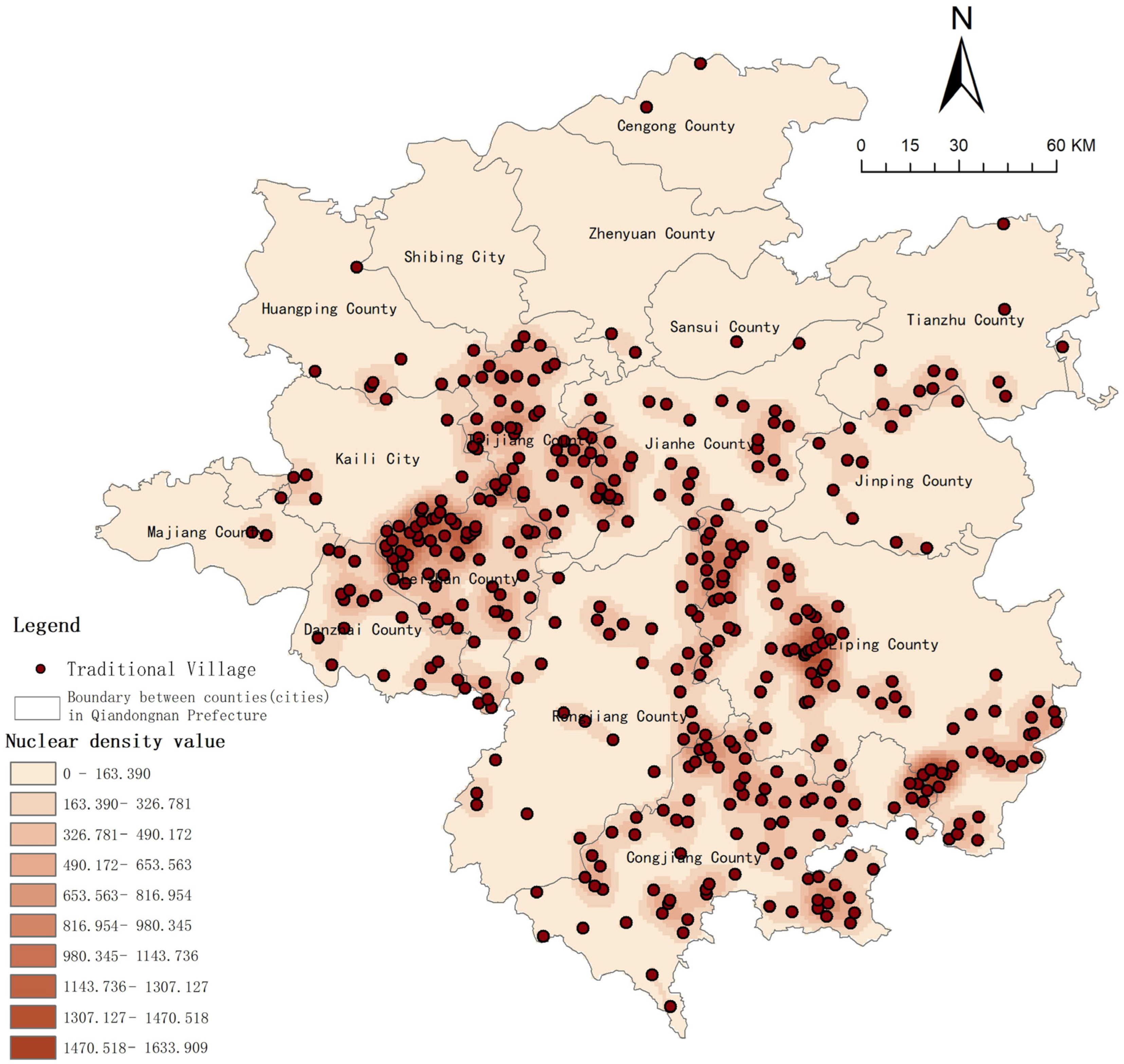
As illustrated in Figure 4, the interval changes in the numerical pairs in the data (0–1633) indicate that the density or spatial distribution of traditional villages in Qiandongnan exhibits a distinct gradient characteristic. The low-value area (0–490) corresponds to the core settlement areas or flat regions where village distribution is dense. The mid-high value area (490–1633) extends toward mountainous or peripheral regions, where density gradually decreases, reflecting a “core-periphery” diffusion pattern. Some numerical pairs demonstrate significant interval jumps, indicating discontinuities in village distribution caused by topographic features such as mountains and rivers, resulting in a pattern of local concentration interspersed with gaps. The spatial distribution of traditional villages in Qiandongnan is characterized by “dense cores, sparse peripheries, and local jumps.” Intervals with values exceeding 1000 are primarily found in the surrounding areas of Leigong Mount and Moon Mountain, which are resource-rich valleys and basin regions. This suggests that topography and geomorphology are critical components of the natural geographic environment, playing a decisive role in the initial selection of traditional villages’ locations and significantly shaping the early spatial patterns of these villages.
As shown in Table 1, the geographic concentration index of Qiandongnan Prefecture is 38.28, and the disparity between the maximum and minimum values of the geographic concentration index for each county is nearly 75, indicating a significant imbalance at the county level. Additionally, the nearest neighbor index in Qiandongnan Prefecture is 0.84, while it is observed that the nearest neighbor index for the remaining villages exceeds 1. This finding also indicates that some villages at the county level have a relatively uniform distribution. Therefore, the spatial distribution of traditional villages in Qiandongnan exhibits a complex pattern characterized by “both concentration and dispersion, as well as a blend of proximity and isolation.”

3.1.2. Characteristics of the Spatial Distribution of Traditional Villages in Qiandongnan

A field investigation was conducted on the current development status of 415 traditional villages in Qiandongnan Prefecture. Based on classification criteria [insert criteria], the villages were categorized into distinct development types. Combined with the spatial distribution pattern analysis presented earlier, the results are summarized in Table 2. As indicated in Table 2, the development of traditional villages in Qiandongnan Prefecture can mainly be categorized into five types: Agricultural Development Type, Craft Experience Type, Ecological Landscape Type, Science Popularization Education Type, and Homestay Leisure Type, with the Agricultural Development Type being the most prevalent. The differences in development types primarily depend on specific classification elements, while the spatial distribution characteristics are influenced by the type of development. The Agricultural Development Type demonstrates a trend toward concentrated development, and it is observed from Figure 5 that the terrain and transportation network requirements for agricultural development are the driving factors behind its intensive growth, the distribution of cultural heritage and the location of transportation nodes are driving factors for the development of the Craft Experience Type, the natural ecological landscape serves as the primary driving factors for the development of Ecological Landscape Type, the ecological cultural resources and government support are driving factors for the development of Science Popularization Education Type, and tourist attractions and transportation arteries are the driving factors for the development of the Homestay Leisure Type. This also indicates that the development types of traditional villages in Qiandongnan Prefecture not only reflect differences in resource endowments and functional positioning, but also embody the complex interplay of historical evolution, ethnic cultural heritage, national policy orientation, and socio-economic transformation.

3.2. Characteristics of Spatial Connectivity in Traditional Villages of Qiandongnan

3.2.1. The Spatial Network Relationships of Traditional Villages in Qiandongnan

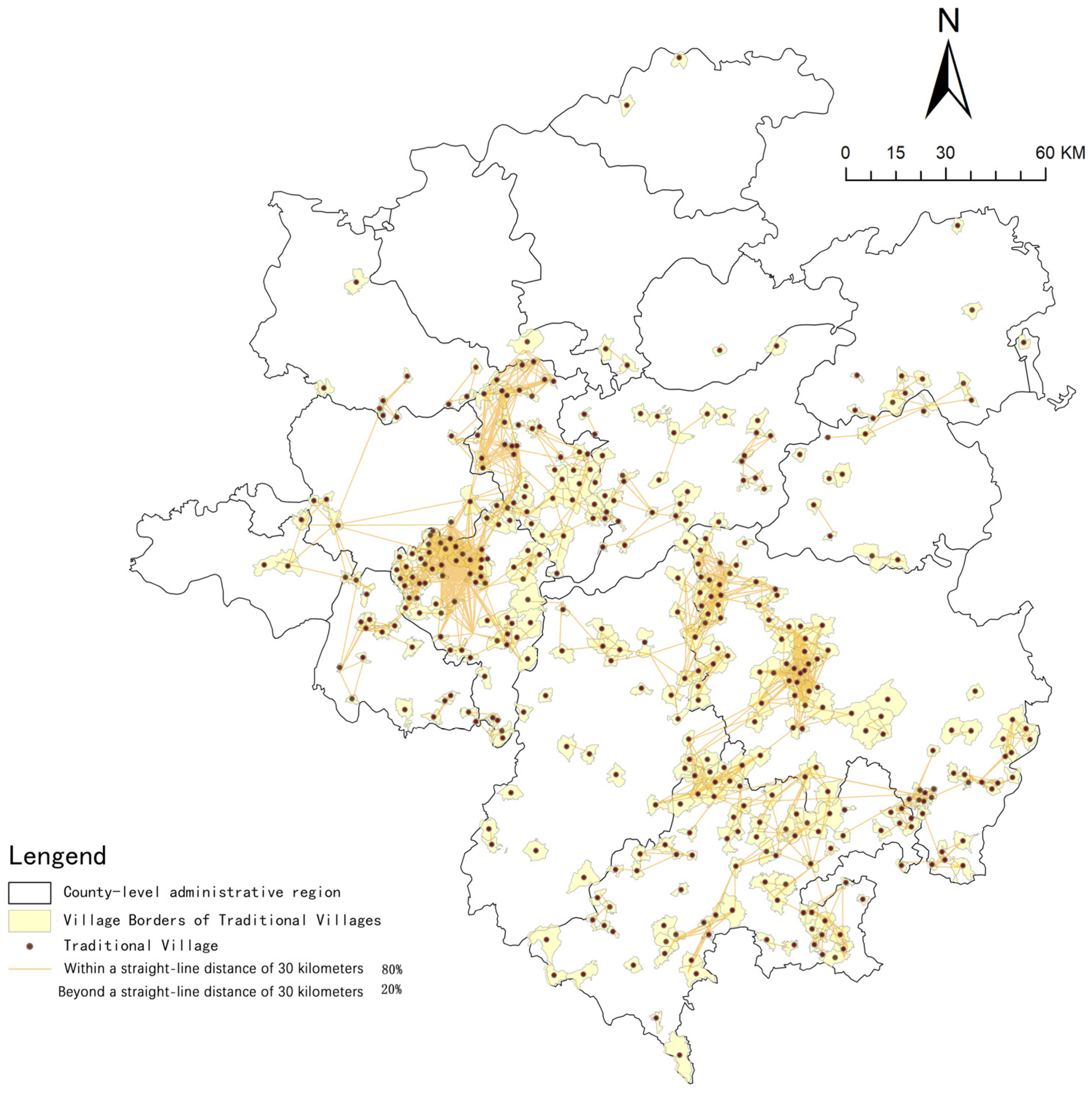
From Figure 6, it can be observed that over 80% of direct connections occur between settlements within a straight-line distance of 30 km. Due to the constraints imposed by terrain features such as mountains and waterways, the travel time by vehicle is non-linearly related to geographical distance. Approximately 35% of the connections overlap with county boundaries, indicating that naturally formed transportation networks partially transcend administrative limits; however, administrative divisions still exert a gravitational influence on resource allocation. The spatial connections of traditional villages exhibit significant characteristics of “network constrained by geography,” profoundly influenced by natural topography and historical path dependence, while also demonstrating a certain degree of self-adaptive optimization capability.
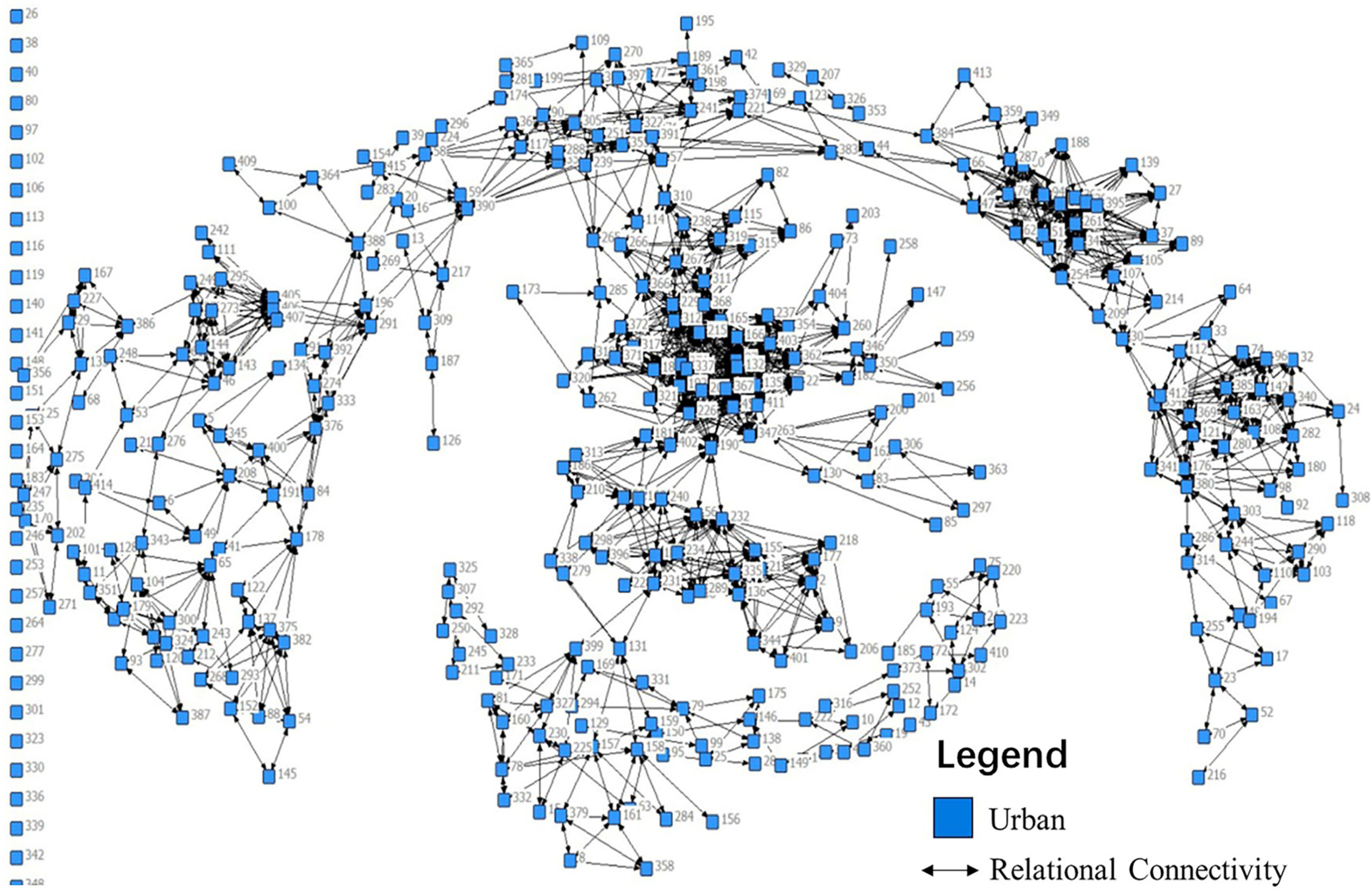
From Figure 7, the network exhibits an uneven, multi-clustered structure, with a small number of isolated nodes, indicating that some traditional villages lack effective relational connectivity. By cross-referencing village identifiers in Figure 2, it is evident that these isolated villages are located at the periphery of regional development and have not been fully integrated into the broader village cluster network. The overall structure reveals a pattern of general connectivity combined with localized density, suggesting that spatial distribution relationships play a significant role in shaping the network’s structural form. Network morphology is characterized by multiple cluster-like groups of varying sizes. A few villages function as critical nodes linking otherwise separate clusters, thereby enhancing the cohesion of the entire network. These key nodes occupy geographically strategic positions and serve as pivotal hubs in the overall system. Therefore, future development efforts should focus on improving network connectivity and enhancing structural resilience.

3.2.2. Spatial Connectivity Relationships of Traditional Villages in Qiandongnan

(1)
Stability Analysis of Spatial Connectivity Relationships
From Figure 8, it is observed that the average K-core value is 4.67, with 146 traditional villages exhibiting K-core values above this average, which accounts for 35.2% of the total. This proportion is relatively small, indicating weak stability in overall spatial connections and suggesting that approximately 60% of non-core villages may encounter challenges in disseminating cultural resources and engaging in economic interactions. Combined with Table 3, the network exhibits a distinct hierarchical structure. Although the agricultural-type traditional villages constitute the largest proportion, they have a relatively low average centrality, indicating that despite their dominant scale, their network cores are relatively weak. This reflects the self-sufficient and relatively closed production model characteristic of traditional agrarian civilization, which lacks mechanisms for inter-village collaboration and thus results in low connectivity within the contemporary village network. In contrast, the number of educational and homestay-type traditional villages is the smallest but has a higher average value, demonstrating that these two types focus on an efficient core within the network. It reflects that in recent years, driven by policies such as rural revitalization, cultural tourism development, and the movement of talents to rural areas, these villages have strengthened their outward connectivity capacities. Sustained over time, this development has resulted in their high level of network centrality. The types and functions of traditional villages in Qiandongnan exhibit a corresponding regularity, where the network stability of different village types closely aligns with their functional positioning. Agricultural types provide foundational social support, homestay types serve as economic driving forces, and science education-oriented types fulfill the role of cultural dissemination. In the future, in the protection and activation of traditional villages, differentiated network optimization and governance strategies should be formulated based on historical context and functional positioning, aiming to achieve resource complementarity and overall synergy.
(2)
Vulnerability Analysis of Spatial Connectivity Relationships
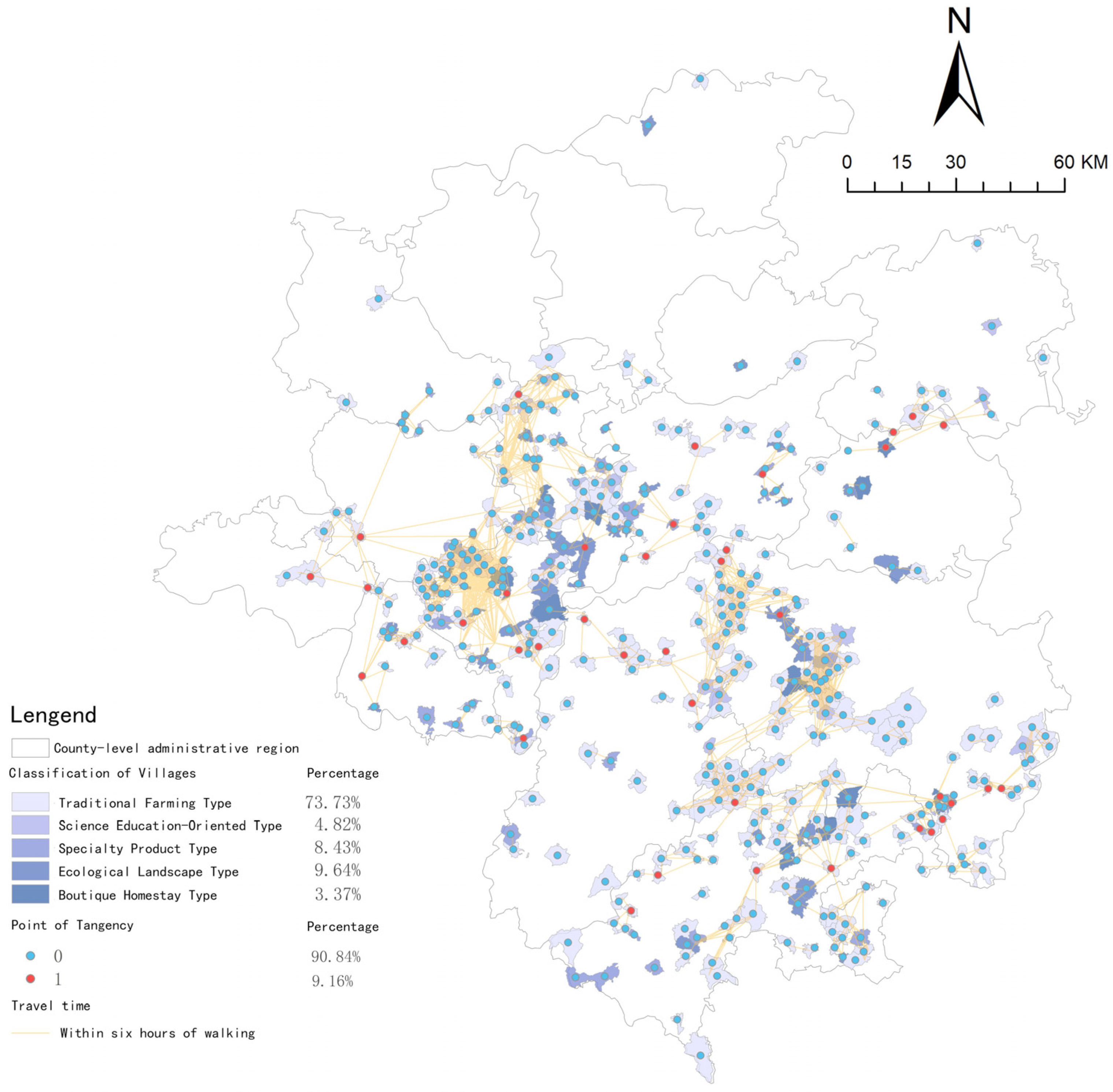
According to Table 4, the number of tangent points in the network relationships of traditional villages in Qiandongnan is 38, accounting for 9.16%, which indicates a relatively high overall vulnerability of the network. The distribution of tangent points is spatially dispersed; however, there are localized aggregation phenomena, primarily concentrated in key traffic nodes within areas with weak transportation systems, which illustrates that traditional villages, as network tangent points, serve as critical breakthrough points in geographical space. Furthermore, as shown in Table 5, boutique homestays and science education-oriented villages have the highest proportions of tangent points, indicating that traditional villages, as network tangent points, also function as hubs for the agglomeration and diffusion of socio-economic and cultural elements. In comparison with Figure 8, Figure 9 illustrates that the K-core values of the tangent points are relatively low, placing them on the periphery of the group structure. This effectively shows their role in bridging the main network with more remote nodes, thus functioning as a ‘point hub’ within the network relationships.
(3)
Balance Analysis of Spatial Connectivity Relationships
The degree centrality potential of the traditional village cluster in Qiandongnan is 7.01%, indicating a relatively weak network equilibrium. A comparison with Figure 10 reveals a distinct core-periphery hierarchical structure in the spatial distribution. The areas represented by red nodes are clearly identified as regional centers, while the regional core does not necessarily align with the geographical core of the area. Furthermore, the degree centrality potential associated with science education-oriented villages and boutique homestay villages is significantly higher, suggesting that in the traditional villages of Qiandongnan, geographical proximity establishes basic connections, while unique functionalities serve as key drivers of value-added connections.

3.3. Analysis of the Development Potential and Strategies for Traditional Villages in Qiandongnan

3.3.1. Construction of an Evaluation Model for the Development Potential of Traditional Villages in Qiandongnan

Table 6 indicates that the industrial foundation, living environment foundation, and resource development foundation are the primary influencing factors on the development potential in Qiandongnan, with the industrial foundation being the most critical (weight 0.65). The evaluation model comprises eight secondary indicators, among which the current state of tourism development exerts the greatest impact on future village development potential (weight 0.49).

3.3.2. Lambda Collection in Different Periods

Figure 11 illustrates three types of development potential for traditional villages in Qiandongnan: advantageous, opportunistic, and ordinary. The ordinary type of development potential accounts for 54.7%, the opportunistic type for 34.2%, and the advantageous type for 11.1%, which indicates that the overall development potential is at a low to medium level. The areas exhibiting advantageous development potential are relatively evenly distributed, suggesting that the balanced regional demand in the market significantly influences the development of traditional villages. The villages with advantageous potential are primarily located in Leishan County and Liping County, which are connected to the national scenic spots of Thousand Miao Villages and Zhaoxing Dong Villages. This finding aligns with the hypothesis proposed by scholars that villages with high development potential often possess a tourism foundation or are influenced by nearby scenic attractions [36]. The results confirm that this concept is generally accurate and that the development potential evaluation model is viable. Furthermore, combining the previous research with Table 7 reveals a positive correlation between development potential and both K-core and degree centrality potential, indicating that the overall stability of the network and its locational centrality are beneficial for the development of traditional villages. Additionally, the development potential of traditional villages associated with science education-oriented type and boutique homestays type is the highest, suggesting that the ability to leverage cultural capital, the experiential value of landscape resources, and the enhancement of cultural tourism consumption are the most advantageous factors in promoting village development.

3.3.3. Development Strategies for Traditional Villages in Qiandongnan

(1)
Overall Protection and Development Strategy for Traditional Villages in Qiandongnan
The development of traditional village clusters in Qiandongnan is directly linked to their internal relationships. A more stable internal connectivity network structure correlates with greater overall development potential. It is essential to maintain the stability, balance, and low vulnerability of these internal connections while preserving the overall spatial pattern, as this serves as the foundation for the flow of people, culture, and materials. Integrating the positioning from higher-level planning with survey data obtained from local investigations, holistically improving the network structure, and adjusting the network structure by targeting key nodes are crucial for achieving regional coordinated development. Therefore, it is crucial to strengthen the connections between high-K core villages and surrounding low-K core villages, optimize the transportation system, reduce network isolation points and commuting times between villages, and enhance the overall stability of network relations. Additionally, for nodes with critical connection functions of tangent points, it is essential to optimize their links between clusters to minimize the presence of critical points and reduce the vulnerability of internal network connectivity among traditional village clusters. Simultaneously, it is important to introduce significant nodes in the sparsely connected areas of the southern network, in accordance with the balanced development needs of the regional market, thereby enhancing internal network density and promoting balanced regional development.
(2)
Strategies for the Individual Protection and Development of Traditional Villages in Qiandongnan
Based on the assessment results of their developmental potential, which are categorized as high, medium, and low, villages can be classified into three types: advantageous, opportunistic, and ordinary. Individual nodes should be prioritized for development based on their importance within the regional network structure. Key nodes should be developed first, and villages with different levels of development potential should adopt differentiated development priorities. For villages with advantageous developmental potential, the focus should be on preserving existing strengths to prevent the erosion of original characteristics due to excessive commercialization. For villages with opportunistic developmental potential, the emphasis should be on increasing awareness and attracting external investments, as well as innovatively developing and utilizing local traditional cultural resources, which integrate tourism with agriculture, aquaculture, and folk crafts, thereby transforming the advantages of traditional village historical and cultural heritage into benefits for the tourism industry and the local economy. For villages with ordinary developmental potential, the focus should be on strengthening the foundational conditions for village development and enhancing agricultural resource advantages. Simultaneously, it should introduce organic and precision agriculture, develop high-end agricultural products through a “small but refined” and “branded” approach, and construct new agricultural demonstration parks and rural leisure tourism complexes. At the same time, it is essential to strengthen mechanisms for community participation. Public engagement should be actively encouraged throughout all stages of rural development—including initial planning, mid-term implementation, and post-project maintenance. Establishing village-level regulations or agreements can enhance grassroots governance capacity and institutional support systems. Furthermore, a sustainable management mechanism should be developed to safeguard ecological and cultural heritage, thereby promoting the long-term sustainable development of traditional villages.

4. Discussion

The uneven distribution of the ethnic minority population in Guizhou Province has resulted in a corresponding uneven distribution of traditional villages. The spatial distribution pattern, characterized by “local large agglomeration and overall small dispersion”, is synchronized with the spatial distribution of ethnic minorities [13]. This observation is consistent with the findings of this study, which suggest a “core dense, periphery sparse, local leap” pattern. The research also indicates that resource-rich valleys and basins are the primary factors contributing to the early formation of spatial patterns in traditional villages. The development of traditional villages in Qiandongnan Prefecture can be categorized into five types: agricultural development, craft experience, ecological landscape, science education, and homestay leisure, with agricultural development being the most prevalent. However, the overall development potential of the agricultural development type is relatively low. Scholars have proposed that spatial network connectivity and morphology are influenced not only by natural topography and land use patterns but also by social contexts and economic activities [37,38]. The study adheres to this principle, indicating that the spatial connectivity network structure of traditional villages exhibits significant characteristics of a “hierarchical network constrained by geography,” profoundly influenced by natural terrain and historical path dependencies, while also demonstrating a degree of self-adaptive optimization capability. Scholars have observed that the internal spatial network connectivity of traditional villages demonstrates high stability and low vulnerability [39]. In contrast, this study finds that the overall stability of spatial connectivity is relatively weak, exhibiting high vulnerability and a distinct hierarchical structure of the network, indicating that the connectivity among traditional villages is significantly stronger than the connectivity between them, which also underscores the independence of individual traditional villages. Scholars have also pointed out that traditional villages dominated by different industries have varying demands for external connections. This study concurs with that perspective and further finds that the network connections among agricultural traditional villages are generally loose, whereas the network relationships among educational, scientific, and homestay traditional villages are more stable. Additionally, scholars have identified spatial imbalances in the connectivity layout of historical urban areas, noting that core regions drive expansion and development as a norm of development stages [40,41]. This study also reveals a weakness in network balance, characterized by a clear hierarchical structure of the network’s core and periphery. Furthermore, it demonstrates that geographic proximity determines fundamental connections, while functional uniqueness is crucial for driving enhanced value connections.
Scholars argue that enhancing spatial connectivity is key to facilitating the exchange of material and intangible flows within a space, thereby enabling sustainable development [26]. The overall development potential of traditional villages in Qiandongnan is assessed to be at a medium to low level. The overall stability of the network, along with the centrality of its location, is conducive to the development of these villages. Enhancing their overall development potential can be achieved by improving the spatial connectivity among them. Scholars have noted that traditional villages are typically located far from central cities, with relatively limited external traffic. In the process of protecting these villages, it is essential to avoid an excessive focus on absolute closure; instead, it is important to improve traffic conditions to facilitate their protection. Furthermore, the rational development of the tourism industry in the region, which has a relatively high level of tourism activity, can significantly enhance the protection of traditional villages [18]. Traditional villages in Qiandongnan have also acknowledged this perspective. Improving the transportation accessibility system can reduce commuting time, particularly in key areas and low-K core regions. It is essential to optimize the internal connectivity of traditional villages, enhance the stability of the network structure, and reduce network vulnerability in order to maximize overall developmental potential. Scholars have suggested that constructing a dynamic evaluation and monitoring system for the development of traditional villages is a critical solution for their advancement [42]. This study aligns with this perspective and has also developed an evaluation model for assessing the development potential of traditional villages, as well as an internal connectivity model. Based on the results of the model computations, strategies for protection, utilization, and development have been proposed, taking a holistic approach that extends down to the individual level.

5. Conclusions

The number of traditional villages in Qiandongnan Prefecture is substantial, exhibiting characteristics of “core density, sparse periphery, and local jumps.” The distribution of natural resources, such as river valleys and basins, is the primary reason for the early formation of the spatial layout of these traditional villages. A review of the current status and development plans for these traditional village groups revealed that over 70% are classified as agricultural development types, with a low degree of industrial differentiation. Their spatial connectivity network is clustered, demonstrating overall connectivity but lacking complete internal cohesion. The spatial links exhibit a significant feature of a “hierarchical network constrained by geography”, with weak stability and high vulnerability in overall spatial connectivity, as well as a lack of network equilibrium. The core-periphery hierarchical structure of the network is prominent, where geographical proximity determines the basic connections, and functional uniqueness is essential for driving value-added connections. The overall developmental potential of traditional villages in Qiandongnan is at a medium–low level; therefore, enhancing network connectivity would be advantageous for the overall development of these traditional villages. By adjusting the spatial connectivity of traditional villages, their overall development potential can be increased. Furthermore, optimization strategies can be proposed at both the overall and individual levels, providing a reference for effectively promoting the protection and development of traditional villages, as well as offering insights that can support the development of other villages worldwide.
In addition, the classification-based development strategies proposed in this study have not fully accounted for the dynamic changes in policy orientation, market conditions, or community resilience. More refined predictions of future development trends and increased stakeholder engagement are needed. Future research should incorporate detailed field investigations based on the specific resource conditions of each village in order to propose targeted development pathways tailored to the unique characteristics of individual villages.

Author Contributions

J.F.: Conceptualization, Methodology, Writing—Original Draft, Funding Acquisition. B.Z. (Bohong Zheng): Conceptualization, Supervision, Writing—Review & Editing. H.Y.: Investigation, Data Curation, Validation. B.Z. (Boyang Zhang): Formal Analysis, Visualization, Resources. P.Z.: Project Administration, Resources, Supervision. All authors have read and agreed to the published version of the manuscript.

Funding

This research is supported by the National Science Foundation for Young Scientists of China, Grant No. 52308057. It is also supported by the Guizhou Provincial Science and Technology Plan Project, Project No: Guizhou Science and Technology Basic Research Contract—[2024] Youth 083 and Guizhou Province Science and Technology Program Project Plan Project, Project No: Guizhou Science and Technology support Research Contract—[2025] General 103. In addition, it is supported by the Guizhou Provincial Science and Technology Plan Project “Cultural Interpretation of the Spatial Texture Evolution of Southern Dong Traditional Villages in Guizhou”, Project No: Guizhou Science and Technology Basic Research Contract—[2023] General 081.

Data Availability Statement

The datasets generated during this study are not publicly available due to confidentiality agreements with the interviewees. However, they can be provided by the corresponding author upon reasonable request.

Acknowledgments

We would like to express our sincere gratitude to the editor and anonymous reviewers for their invaluable comments and constructive suggestions.

Conflicts of Interest

The authors declare no conflict of interest.

References

  1. Chung, H.; Lee, J. Modern Industrial Heritage as Cultural Mediation in Urban Regeneration: A Case Study of Gunsan, Korea, and Taipei, Taiwan. Land 2023, 12, 792. [Google Scholar] [CrossRef]
  2. Wang, H.-f.; Chiou, S.-c. Study on the Sustainable Development of Human Settlement Space Environment in Traditional Villages. Sustainability 2019, 11, 4186. [Google Scholar] [CrossRef]
  3. Wu, C.; Chen, M.; Zhou, L.; Liang, X.; Wang, W. Identifying the Spatiotemporal Patterns of Traditional Villages in China: A Multiscale Perspective. Land 2020, 9, 449. [Google Scholar] [CrossRef]
  4. Zhao, W.; Xiao, D.; Li, J.; Xu, Z.; Tao, J. Research on Traditional Village Spatial Differentiation from the Perspective of Cultural Routes: A Case Study of 338 Villages in the Miao Frontier Corridor. Sustainability 2024, 16, 5298. [Google Scholar] [CrossRef]
  5. Ma, H.; Tong, Y. Spatial differentiation of traditional villages using ArcGIS and GeoDa: A case study of Southwest China. Ecol. Inf. 2022, 68, 101416. [Google Scholar] [CrossRef]
  6. Liu, S.; Ge, J.; Bai, M.; Yao, M.; He, L.; Chen, M. Toward classification-based sustainable revitalization: Assessing the vitality of traditional villages. Land Use Policy 2022, 116, 106060. [Google Scholar] [CrossRef]
  7. Xu, K.; Qian, X.; Wen, Q. Stewardship of built vernacular heritage for local development: A field research in southwestern villages of China. Habitat Int. 2022, 129, 102665. [Google Scholar] [CrossRef]
  8. Chen, X.; Xie, W.; Li, H. The spatial evolution process, characteristics and driving factors of traditional villages from the perspective of the cultural ecosystem: A case study of Chengkan Village. Habitat Int. 2020, 104, 102250. [Google Scholar] [CrossRef]
  9. Hu, Z.; Strobl, J.; Min, Q.; Tan, M.; Chen, F. Visualizing the cultural landscape gene of traditional settlements in China: A semiotic perspective. Herit. Sci. 2021, 9, 115. [Google Scholar] [CrossRef]
  10. Xu, Q.; Wang, J. Recognition of Values of Traditional Villages in Southwest China for Sustainable Development: A Case Study of Liufang Village. Sustainability 2021, 13, 7569. [Google Scholar] [CrossRef]
  11. Li, M.; Yan, Y.; Ying, Z.; Zhou, L. Measuring Villagers’ Perceptions of Changes in the Landscape Values of Traditional Villages. ISPRS Int. J. Geo-Inf. 2024, 13, 60. [Google Scholar] [CrossRef]
  12. Fu, J.; Zhou, J.; Deng, Y. Heritage values of ancient vernacular residences in traditional villages in Western Hunan, China: Spatial patterns and influencing factors. Build. Environ. 2021, 188, 107473. [Google Scholar] [CrossRef]
  13. Su, H.; Wang, Y.; Zhang, Z.; Dong, W. Characteristics and Influencing Factors of Traditional Village Distribution in China. Land 2022, 11, 1631. [Google Scholar] [CrossRef]
  14. Chen, W.; Yang, L.; Wu, J.; Wang, G.; Bian, J.; Zeng, J.; Liu, Z. Spatio-temporal characteristics and influencing factors of traditional villages in the Yangtze River Basin: A Geodetector model. Herit. Sci. 2023, 11, 111. [Google Scholar] [CrossRef]
  15. Liu, C.; Xu, M. Characteristics and Influencing Factors on the Hollowing of Traditional Villages—Taking 2645 Villages from the Chinese Traditional Village Catalogue (Batch 5) as an Example. Int. J. Environ. Res. Public Health 2021, 18, 12759. [Google Scholar] [CrossRef] [PubMed]
  16. Gao, J.; Wu, B. Revitalizing traditional villages through rural tourism: A case study of Yuanjia Village, Shaanxi Province, China. Tour. Manag. 2017, 63, 223–233. [Google Scholar] [CrossRef]
  17. Zhang, J.; Zhang, R.; Li, Q.; Zhang, X.; He, X. Spatial Sifferentiation and Differentiated Development Paths of Traditional Villages in Yunnan Province. Land 2023, 12, 1663. [Google Scholar] [CrossRef]
  18. Liu, X.; Yuan, L.; Tan, G. Identification and Hierarchy of Traditional Village Characteristics Based on Concentrated Contiguous Development—Taking 206 Traditional Villages in Hubei Province as an Example. Land 2023, 12, 471. [Google Scholar] [CrossRef]
  19. Shi, B.; Liu, H.; Huang, L.; Zhang, Y.; Xiang, Z. Increasing Vulnerability of Village Heritage: Evidence from 123 Villages in Aba Prefecture, Sichuan, China. Land 2023, 12, 2048. [Google Scholar] [CrossRef]
  20. Şahin Körmeçli, P. Understanding the Historic Center by Using Network Analysis with Mental Mapping Method: The Case Study of Amasra, Turkey. Sustainability 2024, 16, 5387. [Google Scholar] [CrossRef]
  21. Zhao, L.; Li, Y.; Zhang, N.; Zhang, Z. Public policies and conservation plans of historic urban landscapes under the sustainable heritage tourism milieu: Discussions on the equilibrium model on Kulangsu Island, UNESCO World Heritage site. Built Herit. 2023, 7, 6. [Google Scholar] [CrossRef]
  22. Śladowski, G.; Szewczyk, B.; Barnaś, K.; Kania, O.; Barnaś, J. The Boyen Fortress: Structural analysis of selecting complementary forms of use for a proposed adaptive reuse project. Herit. Sci. 2021, 9, 76. [Google Scholar] [CrossRef]
  23. Wierczynska, K.; Jakubowski, A. Individual responsibility for deliberate destruction of cultural heritage: Contextualizing the ICC judgment in the Al-Mahdi case. Chin. J. Int. Law 2017, 16, 695–721. [Google Scholar] [CrossRef]
  24. Chang, Q. Evolution of Peak Palace-Fortress in Tibet: The Reappearance of the Sangzhutse Palace-Fortress and Design of the Fortress Museum. Built Herit. 2017, 1, 36–49. [Google Scholar] [CrossRef]
  25. Tavares, D.S.; Alves, F.B.; Vásquez, I.B. The Relationship between Intangible Cultural Heritage and Urban Resilience: A Systematic Literature Review. Sustainability 2021, 13, 12921. [Google Scholar] [CrossRef]
  26. Ginzarly, M.; Pereira Roders, A.; Teller, J. Mapping historic urban landscape values through social media. J. Cult. Herit. 2019, 36, 1–11. [Google Scholar] [CrossRef]
  27. Shen, C.; Lu, Q.; Chen, Q.; Zhang, M. Spatial identification and planning strategy of traditional village cluster areas: A case study of mountainous and hilly regions in Zhejiang province. Geogr. Res. 2024, 43, 446–461. [Google Scholar]
  28. Qiandongnan Prefecture Bureau of Statistics. Statistical Communiqué on National Economic and Social Development of Qiandongnan Prefecture in 2020. 2021. Available online: http://www.etmoc.com/eWebEditor/2022/20220611010339643.pdf (accessed on 11 September 2025).
  29. Cai, P. Cultural Preservation and Educational Inheritance of Traditional Villages in Southeast Guizhou; Intellectual Property Publishing House: Beijing, China, 2022. [Google Scholar]
  30. Li, D.; Wang, W.; Zhang, Y.; Chen, S.Y.; Li, H.; Zhu, Q.W. Temporal and Spatial Evolution and Influencing Factors of National Cultural Relics Protection Units in the Yellow River Basin. Areal Res. Dev. 2023, 42, 173–180. [Google Scholar] [CrossRef]
  31. Chen, Y.; Li, R. Spatial Distribution and Type Division of Traditional Villages in Zhejiang Province. Sustainability 2024, 16, 5262. [Google Scholar] [CrossRef]
  32. Zhang, Z.; Cui, Z.; Fan, T.; Ruan, S.; Wu, J. Spatial Distribution of Intangible Cultural Heritage Resources in China and Its Influencing Factors. Sci. Rep. 2024, 14, 4960. [Google Scholar] [CrossRef]
  33. Fang, X.; Tai, P.; Jiang, F. Study on the Spatial Layout and Influencing Factors of Campsites in the Yellow River Basin. Sustainability 2024, 16, 4944. [Google Scholar] [CrossRef]
  34. Liu, J. Analysis of the Entire Network; Shanghai People’s Publishing House: Shanghai, China, 2014. [Google Scholar]
  35. Sun, X.; Si, S. Complex Network Algorithm and Application; National Defense Industry Press: Beijing, China, 2015. [Google Scholar]
  36. Liu, A.L.; Ming, Q.Z.; Yang, C.Y.; Tan, S. Spatial Distribution Characteristics of Traditional Villages in Yunnan, Guizhou and Guizhou and Its Relationship with Tourism Development. China Agric. Resour. Reg. Plan. 2021; in press. [Google Scholar] [CrossRef]
  37. Yiannakou, A.; Eppas, D.; Zeka, D. Spatial Interactions between the Settlement Network, Natural Landscape and Zones of Economic Activities: A Case Study in a Greek Region. Sustainability 2017, 9, 1715. [Google Scholar] [CrossRef]
  38. Salles, T.; Rey, P.; Bertuzzo, E. Mapping landscape connectivity as a driver of species richness under tectonic and climatic forcing. Earth Surf. Dyn. 2019, 7, 895–910. [Google Scholar] [CrossRef]
  39. Yuan, X. Network Relationship and Spatial Network Characteristics of “Ecological-Living-Living-Living” Traditional Villages in Miaodong Traditional Villages in Southeast Guizhou Province. Master’s Thesis, Guizhou University, Guiyang, China, 2022. [Google Scholar]
  40. Zhang, B.; Fan, J.; Zhang, P.; Sha, S.; Ren, Y. The Changsha historic urban area: A study on the evolution characteristics and influencing factors of the connectivity of construction land. Herit. Sci. 2024, 12, 287. [Google Scholar] [CrossRef]
  41. Elzomor, M.; Parrish, K. Investigating Building Construction Process and Developing a Performance Index. Procedia Eng. 2016, 145, 211–218. [Google Scholar] [CrossRef]
  42. Lin, J. Research on village planning and rural architectural design based on discrete dynamic modeling technology. Sci. Program. 2022, 2022, 9031664. [Google Scholar] [CrossRef]
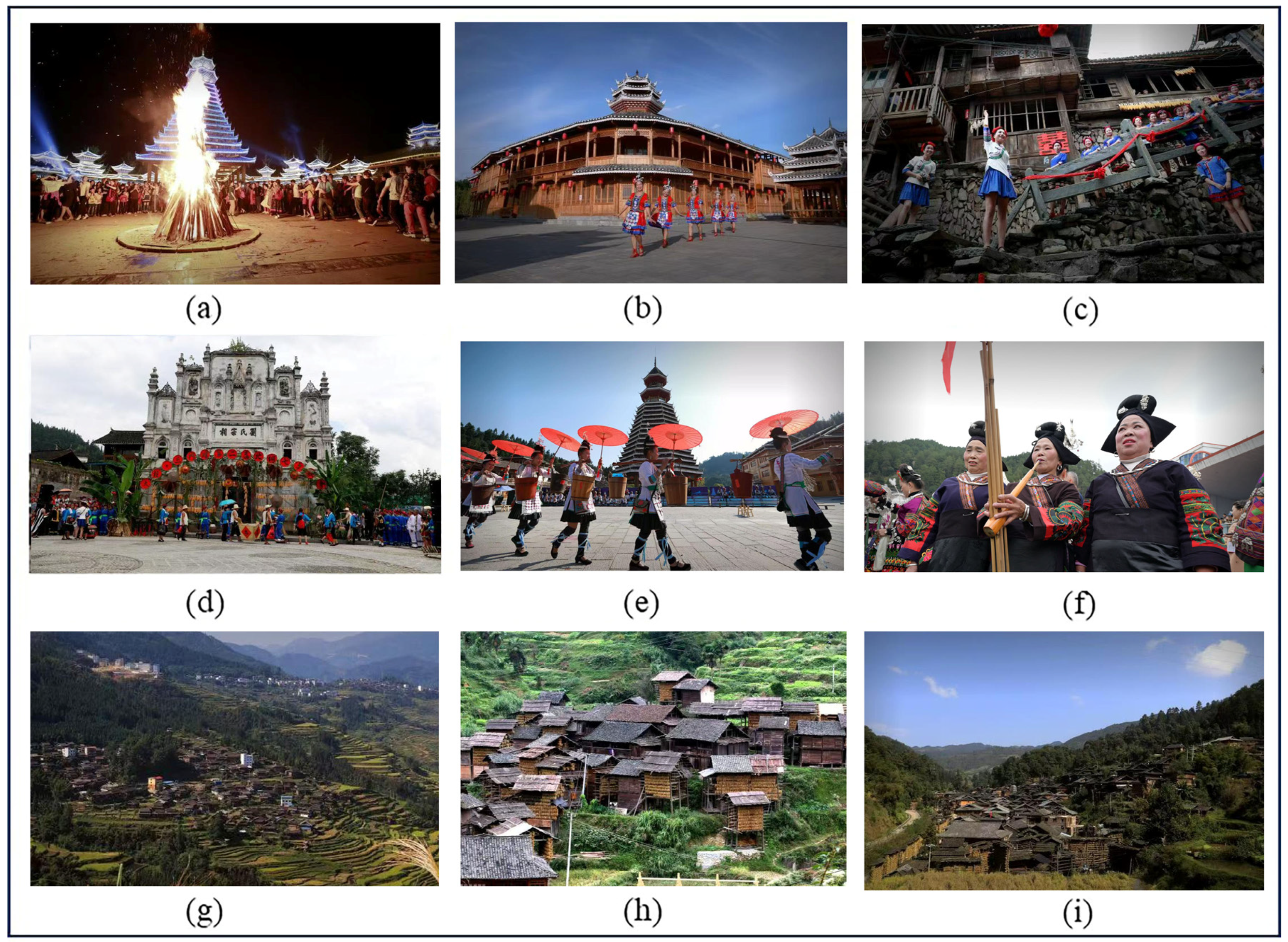
Figure 1. The exhibition of traditional villages and their life scenes in Qiandongnan. (a) Yuping Dong Autonomous County Tianping Town Ethnic Customs Garden; (b) the landmark building of the National Customs Garden in Tianping Town, Yuping Dong Autonomous County; (c) Tianzhu County, Sanmentang Qixi Song Activities: Qixi Festival Greeting Activities; (d) the ancestral hall of the Liu family in Sanmentang Village, Tianzhu County; (e) Xiaohuang Village, Gaozeng Township, Congjiang County: Dong villagers perform Dong songs and dances for tourists; (f) Drum Festival in Leishan County: Miao women perform in a parade to celebrate the Miao Year; (g) panorama of Gaohua Yao Village (Gaohua Village) in Gaohua Village, Congjiang County; (h) part of the village of Huanggang Village, Liping County; (i) landscape map of Zhanli Village, Congjiang County.
Land 14 01929 g001
Figure 2. Location Map of Traditional Villages in Qiandongnan Prefecture.
Land 14 01929 g002
Figure 3. Research approach.
Land 14 01929 g003
Figure 4. Kernel Density Analysis of Traditional Villages in Qiandongnan.
Land 14 01929 g004
Figure 5. Analysis of The Development Types of Traditional Villages in Qiandongnan. (a) Agr iculture+Development; (b) Craft + Experience; (c) Eco + Landscape; (d) Popular science + Education; (e) Homestay+Leisure; (f) Classification of Traditional Villages.
Land 14 01929 g005
Figure 6. Spatial connectivity network relationships of traditional villages in Qiandongnan.
Land 14 01929 g006
Figure 7. Spatial connection network model of traditional villages in Qiandongnan.
Land 14 01929 g007
Figure 8. The K value of traditional villages in Qiandongnan.
Land 14 01929 g008
Figure 9. Tangent point distribution map of traditional villages in Qiandongnan.
Land 14 01929 g009
Figure 10. The degree centrality potential of the traditional village cluster in Qiandongnan.
Land 14 01929 g010
Figure 11. Comprehensive Potential Value of Traditional Villages in Qiandongnan.
Land 14 01929 g011
Table 1. Calculation of Spatial Equilibrium Index in Qiandongnan.
The Name of FactoryThe Geographic Concentration IndexThe Nearest Neighbor Index
Qiandongnan Prefecture38.280.84
Cengong County70.711.18
Congjiang County25.211.22
Danzhai Couty43.621.15
Huangping County55.901.16
Jianhe County32.321.13
Jinping County35.211.12
Kaili City50.000.97
Leishan County35.541.04
Liping County27.760.75
Majiang County74.540.62
Rongjiang County30.261.15
Sansui County100.00-
Shibing County100.00-
Taijiang County38.551.07
Tianzhu County47.241.18
Zhenyuan County70.710.46
Table 2. Characteristics of Spatial Distribution and Driving Factors in Qiandongnan.
Type of DevelopmentElements of ClassificationQuantityCharacteristics of Spatial DistributionTypical AreaDriving Factors
Agriculture + DevelopmentAgricultural development plays the leading role, while developing the agriculture + tourism model, adding traditional farming demonstration, and characteristics of mountain high-efficiency agriculture as the main development direction.305High geographical concentration index (50–100), high proximity point index (greater than 1.15)Sansui County, Cengong CountyThe valley plain has fertile land and convenient irrigation; the developed transportation network facilitates agricultural intensification.
Craft + ExperienceWith processing industry + experience tourism as the main development mode, inheriting traditional handicrafts or processing technology, and experience-led traditional handicraft production inheritance and specialty agricultural products processing.36Moderate geographic concentration index (30–50), high proximity (1.15–1.22)Danzhai County, Congjiang CountyThe core areas of ethnic culture, such as the Miao and Dong inhabited regions, serve as transportation hubs that facilitate visitor access and the circulation of raw materials.
Eco + LandscapeIt is a traditional village with ecological + landscape tourism as the main mode of development, relying on the advantages of ecological environment and natural landscape, and led by ecological tourism and leisure vacation40Low geographic concentration index (<30), moderate proximity (1.0–1.2)Congjiang Couty, Liping CountyThe mountain terraces and forest landscapes are unique; the fragmented terrain leads to dispersion, yet there is a concentration within small areas (such as terrace settlements).
Popular science + EducationBased on ethnic culture, historical culture and red culture, the development of science + culture and tourism is the main mode, with cultural experience and science and education displayed as the leading traditional villages.20Extremely low geographical concentration index (<25), with moderate proximity (0.75–1.0)Liping County, Leishan CoutyRemote yet rich in unique cultural and ecological resources (such as Dong folk songs and traditional architecture), with policy support for the layout of public welfare projects.
Bed and Breakfast (B&B)It is a traditional residential area + leisure tourism as the main development mode, with sports experience and recreation as the main development direction. Relying on natural landscape and humanistic landscape, etc., it is a traditional village led by creating rural lodging.14The geographical concentration index is moderate (30–50), and the proximity is high (>1.0)Kaili City, Zhenyuan CountyService facilities tend to cluster around tourist attractions (such as the ancient town of Zhenyuan) or along major transportation routes, driven by visitor traffic.
Table 3. The Average Value and Number of K Values of Classified Traditional Villages in Qiandongnan.
Classification of VillagesTotal Sum of K-ValuesQuantityAverage of K-Values
Traditional Farming Type1383.003064.52
Science Education-Oriented Type135.00226.14
Boutique Homestay Type98.00166.13
Ecological Landscape Type171.00394.38
Specialty Product Type116.00323.63
Table 4. The characteristics of tangent points in traditional villages in Qiandongnan.
Research SubjectNumber of Tangent PointsProportion of Tangent PointsTangent Points Distribution
Traditional Villages of
Qiandongnan Prefecture
389.16%Land 14 01929 i001
Table 5. The number and proportion of tangent points of classified traditional villages in Qiandongnan.
Classification of VillagesThe Number of Traditional VillagesThe Number of Villages for Tangent PointsProportion
Traditional Farming Type306278.82%
Science Education-Oriented Type22313.64%
Boutique Homestay Type16318.75%
Ecological Landscape Type39512.82%
Specialty Product Type3213.13%
Table 6. Evaluation Index System for the Development Potential of Traditional Villages in Qiandongnan.
First
Indicators
Secondary
Indicators
Evaluation Rating A (9 Scores)Evaluation Level B (6 Scores)Evaluation Level C
(3 Scores)
WeightsWeights
Industrial Development Foundation, Primary industrial baseModernization of agriculture, with special characteristics and on a large scaleTraditional agriculture predominates, with a small amount of modern agriculture beginning to developAgricultural development model as traditional agriculture0.160.65
Status of tourism developmentThe village has developed the tourism industry for more than two years, and the volume of tourism is more than 60,000 tripsDevelopment of tourism industry in the village for more than one year, and the volume of tourism is more than 40,000 visitorsThe tourism industry is in a poorly developed or underdeveloped state.0.49
Human Settlements FoundationserviceHabitat improvement projects such as water supply and sewage treatment have been completed, and there are comprehensive management, education and medical facilitiesHabitat upgrading works such as water supply, sewage treatment, etc., partially completed, and some management, education and medical facilities availableAverage habitat and amenities0.050.08
environmentThe overall style of the village continues to be intact, with no mixed modern-style buildings and good ecological environmentThe overall landscape of the village continues to be relatively intact, partially mixed with modern-style buildings, and the ecological environment is relatively goodThe continuation of the village landscape is basically intact, with more mixed buildings and an average ecological environment0.02
Architectural qualityTraditional buildings are well preserved as a whole, with a vacancy rate of less than 10 per centOverall preservation of traditional buildings is average, with a vacancy rate of less than 20% in the hollow coreOverall preservation of traditional buildings is poor, and the rate of hollowing out and idling is higher than 20 percent0.02
Resource Development FoundationModel evaluationsNational titles such as national-level historical and cultural villages, national-level intangible cultural heritage or national-level characteristic villagesProvincial titles such as Provincial Famous Historical and Cultural Village, Provincial Intangible Cultural Heritage or Provincial Characteristic Villages(sth. or sb) else0.080.27
accessible via transportationWithin half an hour’s drive of a city or a well-connected major attractionWithin half an hour to an hour’s drive of a city or a well-connected major attractionMore than 1 h’s drive from the city or a well-connected major attraction0.14
Resource elementsTwo or more state-protected units or three or more provincial-protected units, the village is rich in natural and human elements (ancient trees, ancient bridges, water systems, courtyards, etc.) and rich in cultural heritageOne or more national conservation units or two or more provincial conservation units, more natural and human elements (ancient trees, ancient bridges, water systems, courtyards, etc.) in the village, more cultural
heritage
The village has more natural and human elements (old trees, old bridges, water systems, courtyards, etc.) and has cultural heritage0.04
Table 7. Distribution of Development Potential in Traditional Villages of Qiandongnan.
Stage Value of Development PotentialClassification of VillagesNumber of Traditional VillagesThe Proportion of Village Types with Potential for Development Relative to the Total Number of Villages of That TypeNumber of Villages for Development Potential ValuesProportionTotal Sum of K-ValuesAverage of K-ValuesTotal Sum of Degree Centrality PotentialAverage of Degree Centrality Potential
1.439700–1.872900Traditional Farming Type18058.36%22554.22%601.002.67880.003.91
Science Education-Oriented Type1152.38%
Boutique Homestay Type213.33%
Ecological Landscape Type1640.00%
Specialty Product Type1650.00%
1.872900–2.848800Traditional Farming Type11035.83%14234.22%800.005.631165.008.20
Science Education-Oriented Type628.57%
Boutique Homestay Type426.67%
Ecological Landscape Type1230.00%
Specialty Product Type1031.25%
1.872900–2.848800Traditional Farming Type175.54%4811.57%327.006.81509.0010.60
Science Education-Oriented Type419.05%
Boutique Homestay Type960.00%
Ecological Landscape Type1230.00%
Specialty Product Type618.75%
Disclaimer/Publisher’s Note: The statements, opinions and data contained in all publications are solely those of the individual author(s) and contributor(s) and not of MDPI and/or the editor(s). MDPI and/or the editor(s) disclaim responsibility for any injury to people or property resulting from any ideas, methods, instructions or products referred to in the content.