Review

An Ecogeomorphological Approach to Land-Use Planning and Natural Hazard Risk Mitigation: A Literature Review

by
Zhiyi Zhang
*,
Jakub Tyc
and
Michael Hensel
Research Department of Digital Architecture and Planning, TU Wien, Karlsplatz 13, A-1040 Vienna, Austria
*
Author to whom correspondence should be addressed.
Land 2025, 14(9), 1911; https://doi.org/10.3390/land14091911
Submission received: 11 July 2025 / Revised: 13 August 2025 / Accepted: 16 September 2025 / Published: 19 September 2025

Abstract

The overarching topic of this article is land-use planning (LUP) for risk mitigation of natural hazards. In this context, landslides are one of the most destructive natural hazards, resulting in significant negative impacts on humans, ecosystems, and environments. This study presents a semi-systematic review of emerging ecogeomorphological principles for LUP to advance the mitigation of landslide risks. By integrating ecological and geomorphological systems, an ecogeomorphological approach offers a novel perspective for tackling landslide risk mitigation. This includes accounting for factors such as water flow accumulation, fractional vegetation cover, and soil erosion, using computational methods, applying artificial intelligence (AI) to process and predict risk, and integrating the internet of things (IoT) to real-time environmental data. We primarily explore the role of ecogeomorphology in fostering sustainable and risk-aware LUP, as well as how landslide research can be applied within LUP to strengthen broader management frameworks. The study reveals much evidence of ecogeomorphological factors in LUP, emphasising the integration of ecology, geomorphology, and hydrology for effective landslide mitigation. With the ongoing shift from traditional to emerging methodologies in risk management, our review addresses the existing research gap by proposing an up-to-date ecogeomorphological framework for practice.

1. Introduction

Landslide hazards constitute a major threat to human life, the environment, and ecosystems. Over the past few decades, much research has focused on this topic. The impact of landslides can be small or large in extent and scale, as well as direct or indirect [1]. A landslide is defined as a mass movement of earth, soil, or rock down a slope under the influence of gravity [2]. Causes, L. [3] mentions that there are multiple triggers of landslides, including rainfall, earthquakes, and deformation, whose underlying causes may be geological, morphological, climatic, or human. A recent example is the Swiss mountain village of Brienz, which experienced massive landslides in May 2023 and November 2024, forcing residents to evacuate their homes. Over several weeks, rockslides occurred increasingly further downhill due to changes in weather and climate. While the early warning system saved the lives of the residents, hazard warning is only a last resort. Predictive planning and management can reduce economic and social losses, saving people’s lives and property from hazard-prone areas [4]. As this review highlights, a land-use planning (LUP) framework for dealing with such risks during the planning stages is lacking. We propose a novel approach based on ecogeomorphology, an emerging interdisciplinary knowledge domain that involves ecology, geomorphology, and hydrology [5]. Ecogeomorphic processes influence vegetation patterns and soil resource distribution in the local environment, such as plant diversity and microtopography [6,7]. Geological, climatic, and morphological factors are not primary considerations in our study frameworks. However, since many of them constitute fundamental variables of hydrological, ecological, and geomorphological processes [8,9], we have considered factors such as annual rainfall, geological structure, and soil texture from the ecogeomorphological perspective. A more comprehensive study of all of the involved geological and climatic factors would go beyond the scope of this review but will need to be revisited to sharpen and direct the emerging questions as research proceeds.
Since around 1900, ecogeomorphology and biogeomorphology have gained increasing interest as related areas of research, though they are sometimes treated as identical [10,11,12]. However, according to Wheaton et al. [13], they reflect two distinct focuses: the study of biological processes’ influence on weathering, and the study of ecological dynamics on erosion and deposition processes. Ecogeomorphology raises an as yet unanswered question concerning the relation between ecology and geomorphology, and between life and landscape, including the complex interactions between organic and inorganic components [14]. Key ecogeomorphological concerns in the various domains include environmental reconstruction, ecological engineering, and built environment studies [15]. Organism engineering introduces a dynamic perspective, which entails actively co-constructing a new environment, as organisms adapted to current surroundings change ecosystem function, community dynamics, and selection pressure [16]. This co-construction is a natural process, in which soil, vegetation, and organisms interact and coexist, thereby enhancing environmental resilience. These dynamics respond to the geomorphic process and contribute to shaping new physical environments over time. In addition, geomorphic processes can restrict the growth of vegetation, establishing feedback loops between plant dynamics and geomorphic activities that might result in debris flows, rockfall, landslide, and other processes that shape the landscape [17]. The rapidly evolving discipline of ecogeomorphology provides a perspective that can address multidisciplinary questions by integrating the knowledge domains of ecology, geomorphology, and hydrology in the study of plants, animals, and microorganisms in the geomorphic process [18,19].
Several researchers have shown how useful the ecogeomorphological approach is for determining the hydrological, ecological, and geomorphological features in river systems [5,20]. Regional ecogeomorphological conditions have been examined to understand environmental components [21]. According to O’Briain et al. [22], river restoration has been found to be significantly influenced by vegetation, which affects hydrological and geomorphological dynamics. An ecogeomorphological perspective indicates that anthropogenic changes can harm plant and animal habitats, and that a suitable wetland management strategy is required to lessen their effects [23]. In dryland areas, land degradation and deforestation can be exacerbated by ecogeomorphological processes [19,24]. This interdisciplinary approach has a broader application in addressing environmental issues; however, land-use change entails critical global challenges that drive ecosystem change [25,26].
This article presents a semi-systematic review that examines an ecogeomorphological perspective for LUP and risk mitigation, with the aim of identifying research gaps, thereby facilitating further research based on this study. LUP is one of the current strategies to improve the resilience of disaster risk management (DRM). It focuses on land policy formation, land development, and reducing environmental vulnerability [27]. LUP serves, among other goals, the purpose of reducing or eliminating natural hazard risks. This is frequently conducted in conjunction with a policy approach for DRM. In this context, LUP aims at governance and sustainability for pre-, during-, and post-disaster phases [28,29]. Many LUP approaches provide similar strategies, sustainable management, development, protection of hazards, and support for human well-being, health, and safety [30,31,32]. Risk perception is an important element in risk-based LUP and is closely related to hazard awareness and investment in activity [33]. The term “risk reduction” refers both to identifying and implementing measures to mitigate risks that natural or non-natural hazards pose to human life and property [34]. In many LUP documents, “acceptable risk” is mentioned [35,36]. It is therefore crucial to define guidelines for communities, developers, and governance that include various viewpoints on what constitutes acceptable risk [37]. It is for this reason that identifying the essential elements for reducing the risk of landslides is required. Meanwhile, population growth and rapid urbanisation, and the related decrease in available hazard risk-free areas, necessitate creating safe habitation for people in potentially hazardous areas [38]. LUP gathers and analyses information about hazard-prone areas and provides valuable insights for the various stakeholders, which include potential investors, and policymakers, as well as concerned citizens [39].
Recent advances in emerging methodologies have been implemented in LUP and DRM. These include geospatial platforms and techniques, such as Google Earth Engine [40], cloud-computing platforms [41], artificial intelligence (AI) [42], the internet of things (IoT) [43], and big data analytics [44]. AI techniques are frequently used for prediction, damage assessment, and planning, focusing on data collection and analysis through quantitative and qualitative methods at all phases of a disaster [45,46]. The IoT enables real-time collection of spatial-temporal data, using machine learning (ML) models to process sensor data, location-specific alarms, and enhance predictive accuracy [47]. However, processing the vast array of real-world datasets, satellite images, social media platforms, and sensor data from local environments presents a significant challenge [48]. The different data sources increase the complexity of assessing the type of hazard, date, and location and at the same time maintaining spatial-temporal continuity [49]. Spatial data infrastructure (SDI) enables the integration of these multiple sources, to produce data that allows access and interoperability, and supports decision-making for an early-warning system [50]. In the SDI system, using AI, including deep learning (DL) [51] and ML techniques [52] to harvest spatial data is currently the most common approach [53]. In the context of DRM and LUP, SDI offers a unified database to support the visualisation, mapping, and scenario modelling for risk assessment, planning, and emergency response.
While there are a few reviews that explore the application of ecogeomorphology to specific topics, a review examining ecogeomorphology in LUP and DRM is so far lacking. In this paper, we therefore examine ecogeomorphological perspectives in LUP and DRM, and more specifically, the topic of landslide risk. Our semi-systematic review is designed to establish and refine the scope of inquiry, providing a synthesis of interdisciplinary knowledge. We therefore address the following research questions:
  • Can landslide research be applied in LUP to enhance broader DRM frameworks?
  • Does ecogeomorphological research play a role in fostering the development of risk-aware LUP?
  • What are the main ecogeomorphological factors that affect landslides in LUP?

2. Materials and Methods

For this article, we conducted a semi-systematic review coupled with a descriptive review to gain insight into our specific domain of interest.
The interdisciplinary aspect of ecogeomorphological research, which encompasses several conceptualisations, spanning ecological, geological, and hydrological issues, was addressed in this review using a semi-systematic approach. Wong et al. [54] emphasise that the topics interpreted variably across many disciplines are especially suitable for this review approach. One of its key advantages is its capability to map the current state of ecogeomorphological, landslide hazard, and LUP knowledge while identifying emerging trends and research gaps. To synthesise relevant findings, we applied a combination of thematic and content analysis [55]. This review process began with the search strategy aligned with the research aim and research questions. The Web of Science and Scopus databases were used to locate scientific sources. Following this, we created specific inclusion and exclusion standards to filter out irrelevant studies. Following the screening process, a descriptive review was conducted to extract information on key research topics, trends, and findings [56,57]. To support this synthesis, VOSviewer (v1.6.20) as a visualisation tool was employed to map keyword co-occurrences and identify clusters of thematic foci across the literature. For each selected article, we extracted specific characteristics, such as publication year, research methods, and other relevant variables [58]. These variables were analysed in terms of their frequency distributions to offer quantitative insights into ecogeomorphological factors, and each article served as a unit of analysis for this review. Additionally, we use citation tracing to collect related references from the articles gathered in the semi-systematic review as “seed references”. Indirect and direct citation references, both backward and forward, were conducted to identify how each article contributed to shaping future research directions and conceptual developments, and to reduce the omission of key articles related to the topic [59]. This allowed us to assess the content of the existing literature and the broader influence within the research fields, including conceptualisations and methods [60]. Overall, the descriptive review, in its entirety, gives a summary of the field’s existing level of knowledge, knowledge gaps, and possible directions for future research [61].

2.1. Data Collection and Screening

Web of Science and Scopus were searched for the resource content, using the following search terms and keyword combinations:
(“landslide”) AND (“ecogeomorphology” OR “biogeomorphology” OR “ecological geomorphology” OR “eco-geomorphology” OR “ecogeomorphological” OR “ecology” OR “geomorphology” OR “landscape engineering” OR “eco-evolution” OR “landscape evolution”) AND (“land use planning” OR “land use” OR “land cover” OR “planning” OR “risk management”).
Our literature selection process is shown in Figure 1. The first run resulted in 1026 articles (459 in Web of Science, 567 in Scopus) searched for from 2005 to 26 January 2025. The results include completed data from 2005 to 2024, and partial data from 2025. Duplicate records were removed from 185 articles automatically, following which 14 articles were excluded from 2025 due to the incomplete data availability at the time of analysis. Our analysis was thus based on articles from 2005 to 2024. The remaining 827 articles for the title and abstract reading in the screening process were then further filtered by keywords and abstract, such as “landslide”, “ecology”, “geomorphology”, and “land-use”. This excluded a further 784 articles irrelevant to the focal topic of this article. Next, the specific inclusion and exclusion criteria were applied (Table 1) to a total of 43 articles. Further detailed checking of titles and abstracts reduced the total number of articles to 26, which were included in this study. While this selection process focuses on a limited number of core studies for in-depth thematic analysis, additional studies identified through backwards and forward citation tracking in our descriptive review are included, thereby reducing the omission of important articles and the latest research in our review. The structure follows that of a systematic review, with strengthened transparency and organisation at every stage, from search strategies and topic keywords to selection criteria and citation tracking. The search strategies were designed to include words with similar meanings while also incorporating specific keywords to facilitate the exclusion of irrelevant articles. This ensured that only studies closely related to our purpose were retained. Each step was aligned with the systematic review framework, with an expanded scope for citation tracking and traceable keyword extraction from the original articles in the descriptive review. We also clarified how context-based interpretations were made when the evidence was not explicit. Together, these measures enhanced the objectivity and scientific rigour of the review.
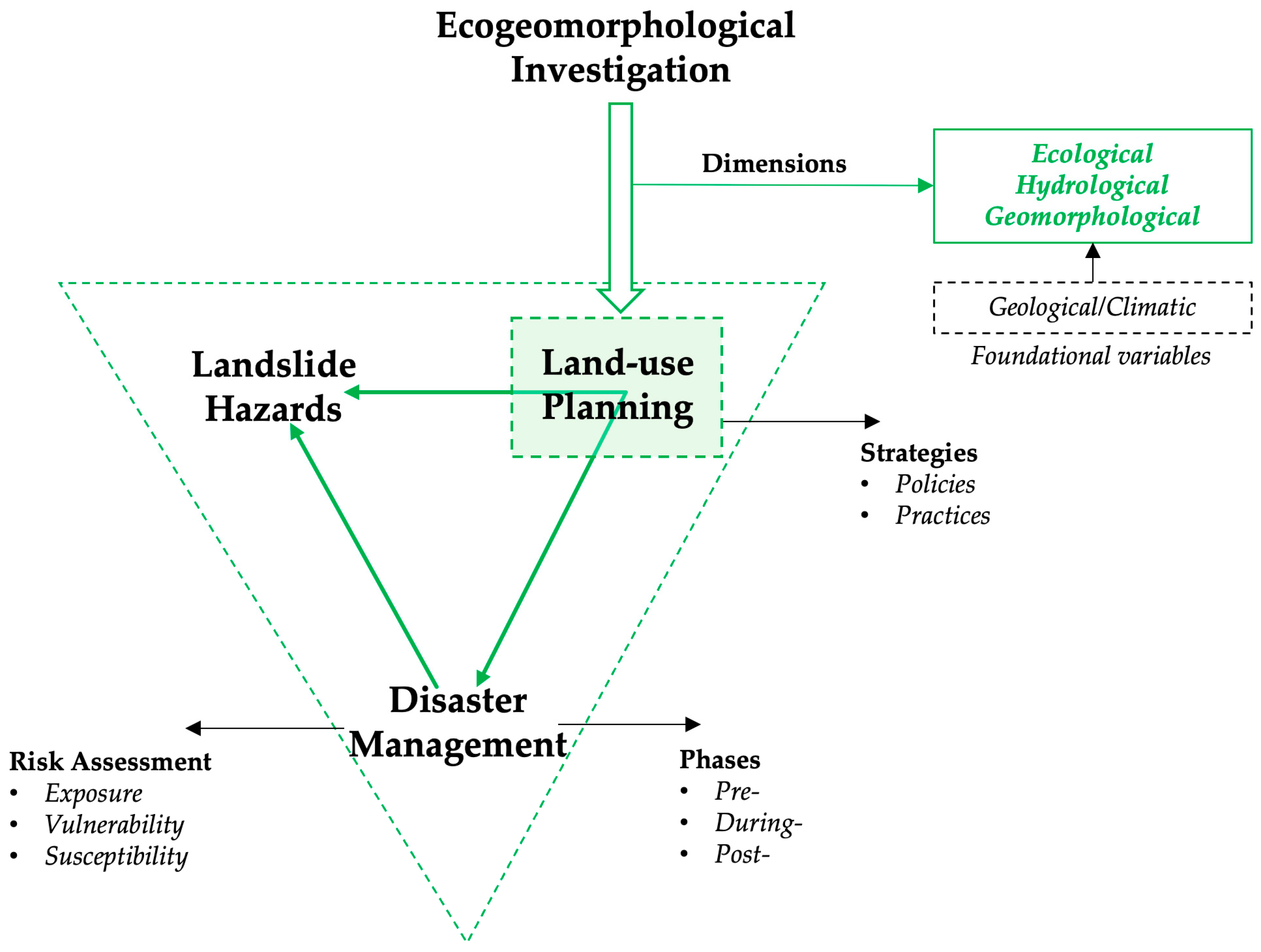
Next, an investigation structure was established was developed for this study (Figure 2). A concept-centric approach served to focus on land use and landslide management, related to ecological, geomorphological, and hydrological dimensions. The articles were grouped in accordance with (1) focal topics, i.e., land-use planning as a method for disaster management, (2) time-related aspects such as pre-, during-, or post-disaster, and (3) policies or practice output.

2.2. Data Interpretation and Descriptive Analysis

VOSviewer was used for keyword and hotspot networking analysis. As a bibliometric visualisation tool, VOSviewer constructs and displays networks based on text mining of selected literature [62]. In the present study, a keyword co-occurrence network was generated to explore thematic structure and research trends within the fields of ecogeomorphology, LUP, and natural hazard mitigation. The resulting cluster analysis enabled the identification of distinct thematic groupings, offering a multi-perspective understanding of how these domains intersect and evolve over time.

3. Research Trends and Scientific Mapping

In this section, we describe the process and findings of the semi-systematic review. This domain and publication analysis, based on the 827 articles after initial filtering, aims to capture the broader research field. The core 26 articles, after a stricter screening process, are further examined for keyword co-occurrence and temporal trends. This section will provide a deeper conceptual understanding of the field of study.

3.1. Research Trends

3.1.1. Research Domains

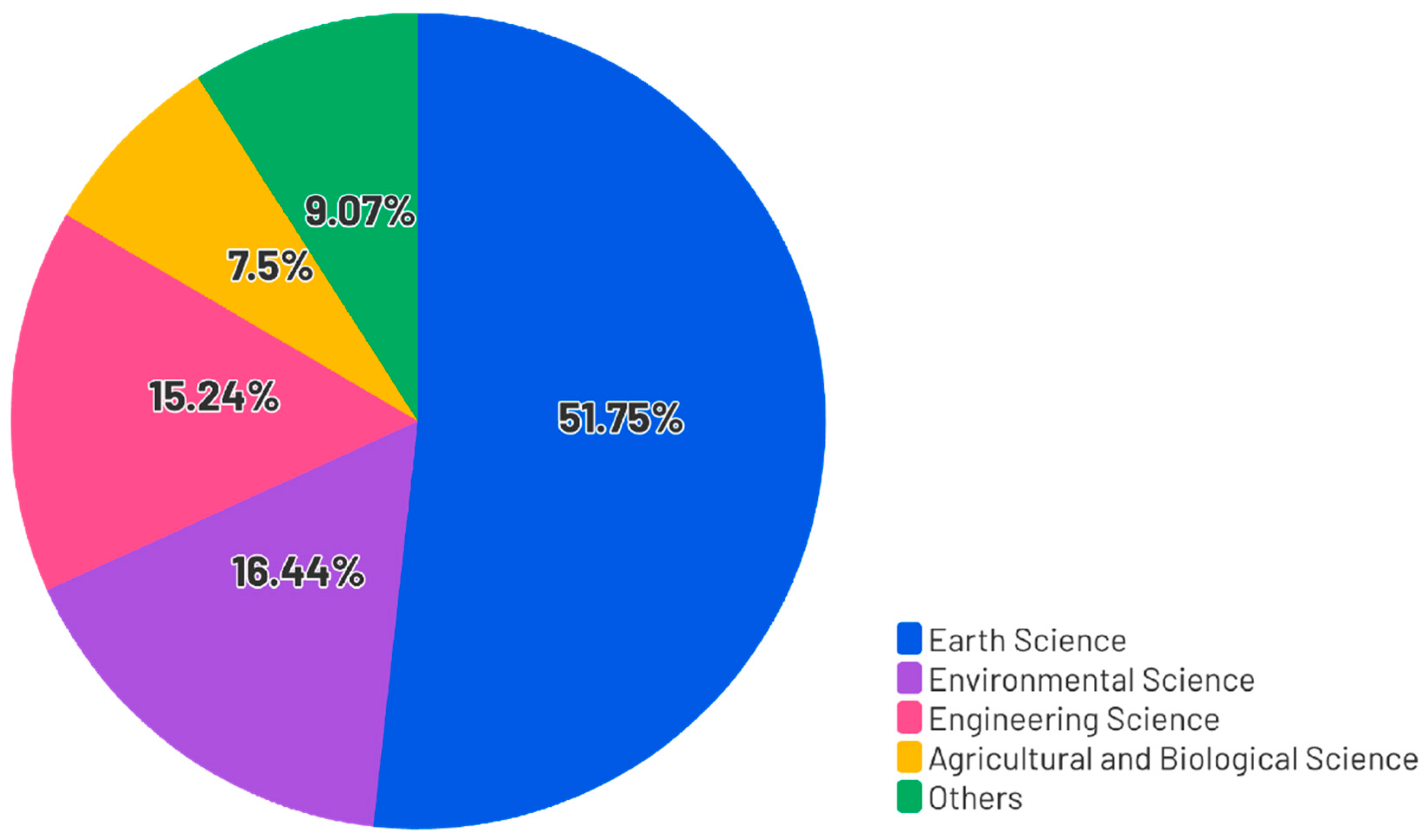
For the research domain analysis, we used the remaining 827 articles from Web of Science and Scopus 2005–2024 after the deduplication process. 428 of these articles fall within the Earth Sciences category, followed by Environmental Science with 136. The next four major fields are Engineering Science (126), Agricultural and Biological Sciences (62), and other disciplines (75) (Figure 3). This disciplinary distribution showed that the most relevant articles appeared in Earth Sciences and Environmental Science, followed by Engineering Science. The prominence of these disciplinary categories reflects the interdisciplinary nature of ecogeomorphology, LUP, and landslide hazard mitigation. These fields address issues that are on the one hand scientific and technical, and on the other hand deeply connected to human life and the anthropogenic transformation of landscapes. The emergence of categories related to earth and environment underscores the urgent need to incorporate these dimensions into policy, planning, and community awareness. These topics are increasingly relevant not just for local resilience, but for the sustainability of human habitats on a global scale.
Furthermore, interdisciplinary studies such as agricultural and biological sciences, economics, and neuroscience, etc., provided significant insights. These studies have explored how ecological and geomorphological processes affect economic and social resilience and decision-making in the context of human risk perception. Human behaviour and perception have been recognised as an interdisciplinary concept in emergency risk management [63]. For example, studies have shown that the farmers’ perception shapes the effectiveness of risk management strategies, which directly affects the economic resilience and social stability in developing countries [64]. Therefore, since tackling these complex subjects from a single perspective is insufficient, multidisciplinary knowledge integration is essential for the holistic implementation of LUP, ecogeomorphology, and landslide risk reduction.

3.1.2. Publication Trends

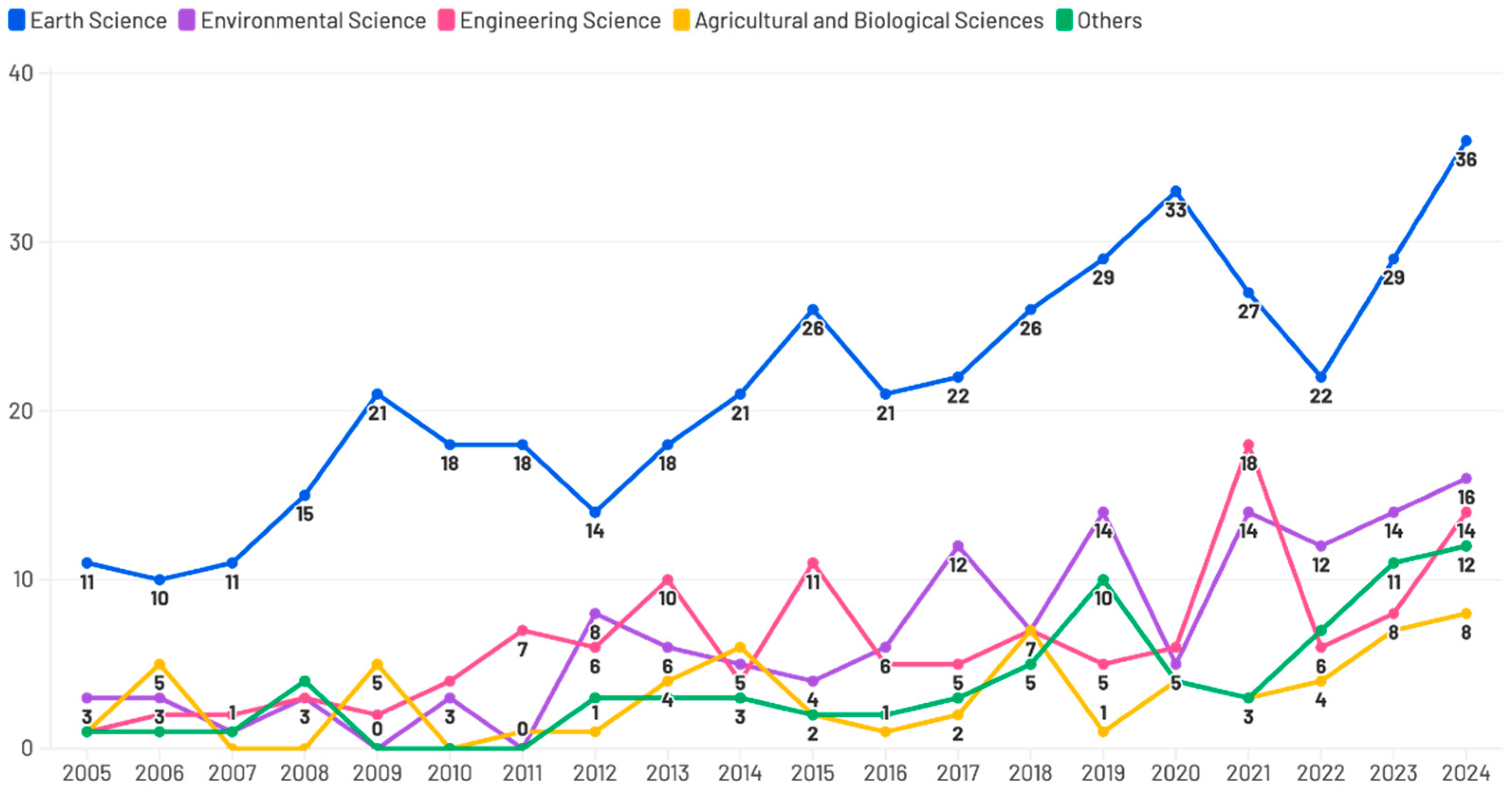
The distribution of 827 published articles across different scientific disciplines from 2005 to 2024 illustrates both global attention and fluctuation over time. The results (Figure 4) show that Earth Science consistently dominated the output, reflecting its status as a primary field of study. This category shows stable growth, peaking at 36 publications in 2024, highlighting the continued relevance of ecological, geological, hydrological, and natural hazard challenges. Environmental Science initially received less global attention, but experienced a noticeable increase after 2011, especially in 2017, 2019, and 2024, indicating a shift in research direction towards environmental concerns. Engineering Science showed steady growth throughout the period, peaking at 18 publications in 2021, emphasising the emergence of new technologies and engineering during this year. Agricultural and Biological Sciences maintained relatively stable outputs with modest fluctuations, exhibiting their limited integration into the broader discussion. Other disciplines displayed minimal fluctuation, reflecting relatively lower consideration of interdisciplinary research.
The data reveal distinct peaks and dips, such as the decline in 2020, which may correlate with global disruptions, like the COVID-19 pandemic, which affected research activities and publications. While the overall trend shows fluctuations, there is a general increase in research output, indicating a growing interest in all of these different scientific disciplines. In summary, the publication trend shows most research activity in the field of Earth Science, with Environmental Science and Engineering Science gaining more global attention in recent years. Agricultural and Biological Sciences still exhibit limited growth, suggesting these disciplines need to further develop to establish themselves in global research.

3.1.3. Keyword Co-Occurrence Network

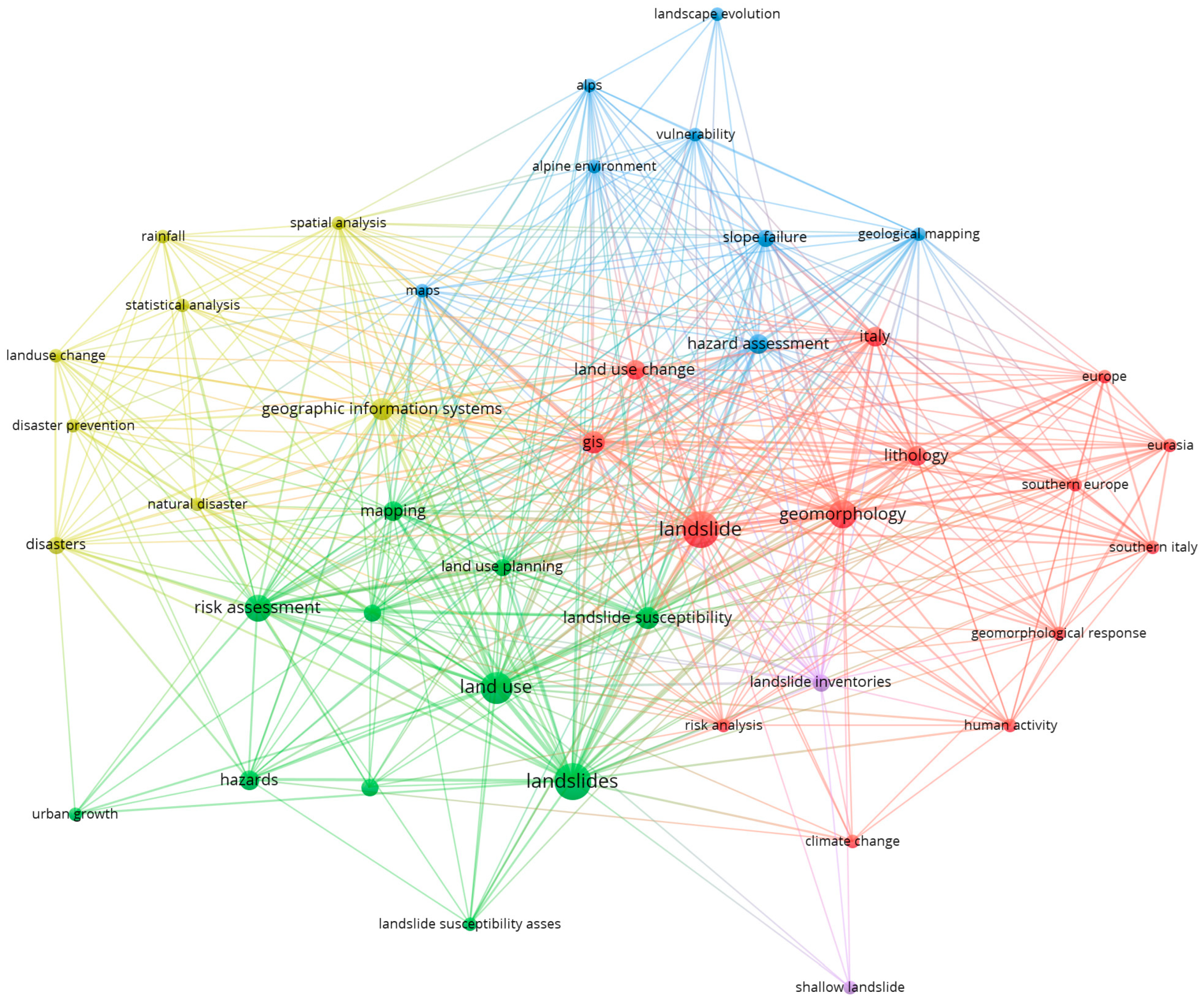
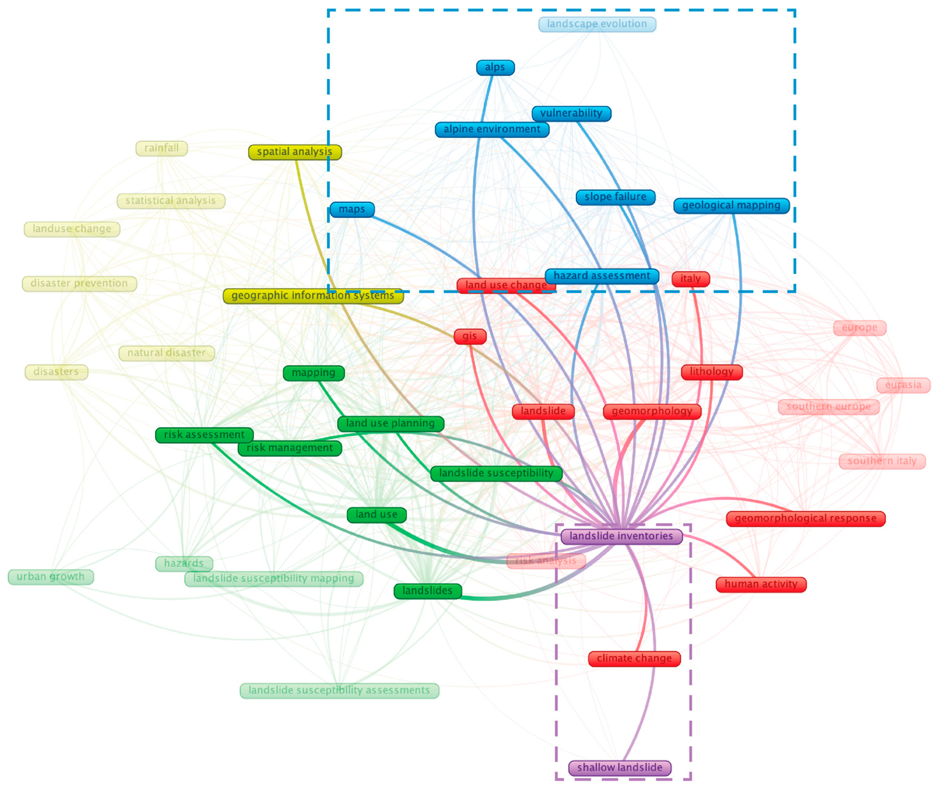
We used VOSviewer to create a keyword co-occurrence network, as shown in Figure 5, which describes the relationship of research keywords in the literature. Each node represents a keyword, with its size corresponding to its frequency of occurrence in the dataset. The larger the node, the more frequently the keyword appears in the 26 analysed publications.
The keywords are grouped into five different clusters, each represented by a different colour:
  • First Cluster (Red) explores how geomorphology, lithology, and climatic factors interact with human activity to shape landslide dynamics, especially in Southern Europe and Eurasia.
  • Second Cluster (Green) focuses on evaluating landslide susceptibility in land-use change and urban development, emphasising risk management techniques.
  • Third Cluster (Yellow) examines geographic information systems, spatial analysis, statistical analysis, and disaster prevention, representing a methodological approach to landslide studies.
  • Fourth Cluster (Blue) concentrates on landscape evolution, vulnerability, and geological mapping, which relate to hazard assessment in mountainous environments.
  • Fifth Cluster (Purple) focuses on the development of landslide inventories and classification systems, indicating the impact of external factors on different landslide occurrences.
The lines connecting the nodes represent co-occurrence relationships between keywords [65]. The thicker lines indicate stronger connections, such as landslide, GIS, geomorphology, vulnerability, susceptibility, and inventories. The network reveals a thematic intersection between ecogeomorphology, LUP, and hazard mitigation, helping to identify spatial risk modelling topics and emerging environmental planning in the field.

3.1.4. Keywords in Temporal Trends

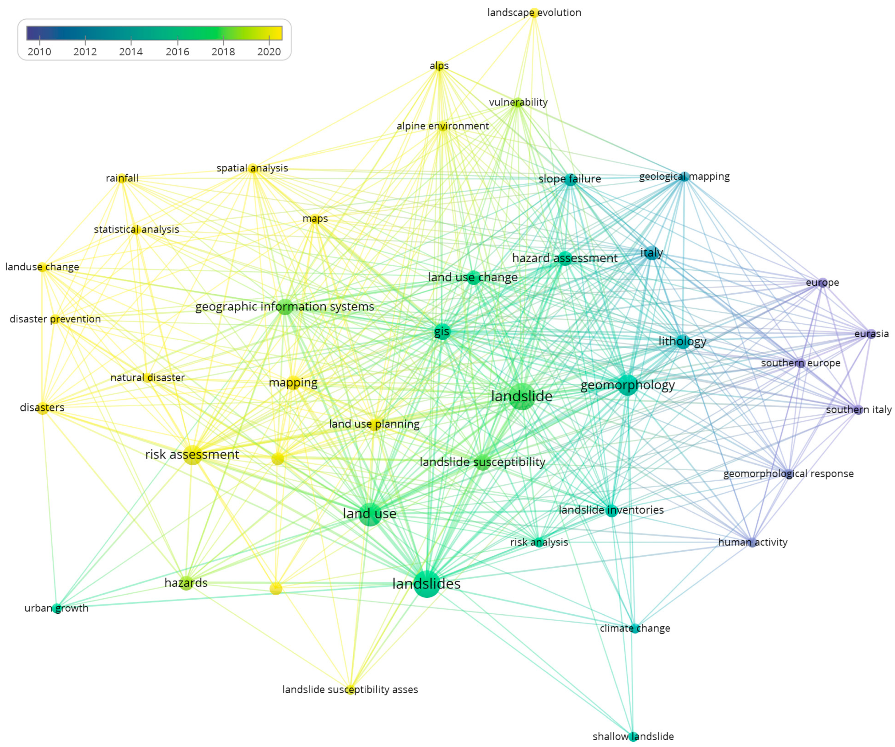
Figure 6 describes a network of research keywords based on their temporal occurrence and relevance. These keywords in temporal trends are like a keyword co-occurrence network but with an additional colour-coded overlay representing the average year of publication for each keyword.
Purple, green, and yellow compose the colour gradient. Purple represents older research topics (around 2010). Green represents temporal relevance (2014–2016). Yellow represents recently emerging topics (2018–2020). Keywords such as “landslides”, “land use”, and “risk assessment” are prominently displayed in green to yellow, indicating their increasing significance in recent years. Meanwhile, terms like “geomorphology” and “GIS” appear in green, which means they have remained consistently relevant over time. In contrast, terms such as “human activity” and “geomorphological response”, which are purple-coloured, indicate research topics that were more prominent in earlier years.
These keywords in temporal trends illustrate the evolution of research trends, helping to identify the intensity of study in the emerging areas and the focus on the shifting of academic literature over time [65].

4. Results

In the present study, we systematically organise and analyse the literature and provide a clear framework for the integration of ecogeomorphology into LUP for landslide risk mitigation. This allows us to outline land-use methods categorised by disaster phases (pre-, during-, and post-disaster), with a focus on policy and regulatory framework, statistics and risk modelling, zoning and land classification, and ecosystem-based solutions as key aspects of landslide risk mitigation.
Ecogeomorphology integrates geomorphological, hydrological, and ecological components, forming a broad field of research that examines how geomorphic processes influence plants, animals, and microorganisms [66]. Our study reveals diverse ecogeomorphological factors across ecological, hydrological, and geomorphological dimensions in different thematic areas. Based on the keyword co-occurrence network generated with VOSviewer, the studies were grouped into five thematic clusters, each represented by a different colour. To enhance thematic clarity, we extracted keywords from each study implicitly or explicitly related to ecological, hydrological and geomorphological dimensions of land use. In cases where land use was not directly mentioned by the article, this was performed based on the context of the article (Table 2).

4.1. First Cluster (Red): Geomorphological Processes and Human Drivers of Landslides

4.1.1. First Cluster Key Literature Topic

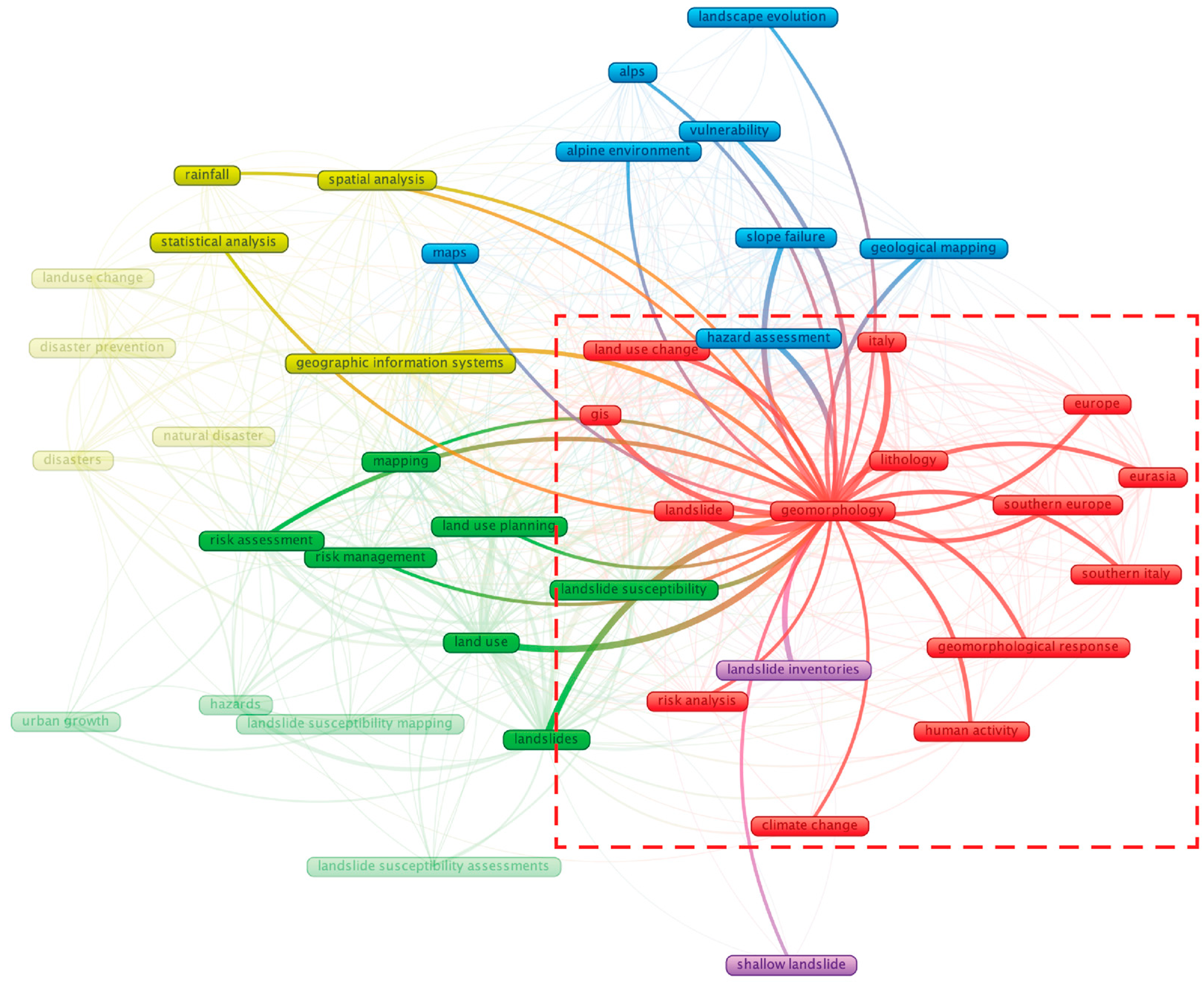
The first cluster (red colour) (Figure 7) included fourteen items: climate change, Eurasia, Europe, geomorphological response, geomorphology, GIS, human activity, Italy, land-use change, landslide, lithology, risk analysis, Southern Europe, and Southern Italy. The considerable interconnections between the different colours of the network map highlight the integration of geomorphological analysis, hazard assessments, and human-induced factors in landslide dynamics.
The centrality of the term “geomorphology” suggests that research in this cluster primarily focuses on utilising geospatial technologies to map and analyse landslide-prone regions. The inclusion of “human activity”, “climate change”, and “risk analysis” further indicates a growing recognition of anthropogenic influences and environmental variability in landslide occurrences. This aligns with previous studies emphasising hazard risk assessment in specific regions, particularly in Italy, Southern Europe, and Eurasia.

4.1.2. First Cluster Key Literature Detailed Review

The key literature in the first cluster (Table 2) demonstrates that geomorphology plays an essential role in DRM and LUP, particularly when supported by policy in landslide-prone regions. The application of geomorphology has been investigated in hazard reduction, assessment, and LUP [67], particularly when it comes to evaluating assets to choose locations for infrastructure and sustaining human life. Enhancing people’s risk perception is a societal means of hazard mitigation [92]. A unit stream power erosion deposition model was combined with GIS techniques by Capolongo et al. [75] to measure erosion risk and perform prediction analyses. Their results help improve the application of regulation by connecting to the geomorphic response of places. Another conceptual model is provided by Restrepo et al. [74], offering a multi-scale view of the connections of biogeomorphic processes, landslides, and ecosystems in relation to land use, hence aiding in conservation, restoration, and hazard assessment.
Some other studies demonstrated a collaborative mechanism between evaluation and planning. Land management as a crucial human activity has significantly accelerated geomorphic processes in Northern Spanish regions for land instability [71]. The geology and planning teams should collaborate on a plan and map. Coutinho et al. [73] highlight the two tools: geological characterisation and hazard assessment in LUP. To investigate LUP, a multitemporal analysis of orthophotos and aerial photos was carried out [68]. The process for creating landslide hazard maps using GIS techniques is an important contribution to DRM and LUP. In small settlements, a sustainable water management system for landslide prevention through collaboration with multiple authorities is essential for long-term mitigation [69]. The collaborative mechanism is a crucial consideration in the various phases of DRM and planning.
Beyond technical planning, an ecological perspective further enriches the research. In particular, understanding geomorphological structures and river morphology is crucial for ecological conservation and habitat management in vulnerable environments such as habitats of endangered species, river restoration and DRM [72]. In Norway, online services are a sustainable mapping method for detecting landslides and various hazard levels by implementing building and planning, but they only consider the main infrastructure in low-hazard regions for LUP [70].

4.1.3. First Cluster Future Direction

After identifying the first cluster, given the strong connection between geomorphological processes, collaborative mechanisms, and ecological function, potential future research could explore multiple factors influencing geomorphological processes within geospatial techniques. At the local scale, Cuervas-Mons et al. [93] introduced the European ground motion service, which monitors mass movements, including landslides, and Riaz et al. [94] identified groundwater services supporting the long-term sustainability of the ecosystem. Landslides are not only a natural hazard, but also alter the terrain, ecosystem diversity, and human society [95]. Moreover, landslides are key geomorphic processes that contribute to landscape evolution, in some cases having a positive effect [96]. By synthesising geological, ecological, social collaboration, and spatial data, this research cluster contributes to a more comprehensive understanding of how humans co-exist with these natural hazards, utilise the benefits, and support improved risk mitigation strategies and LUP in ongoing research.

4.2. Second Cluster (Green): LUP and Landslide Susceptibility Assessment

4.2.1. Second Cluster Key Literature Topic

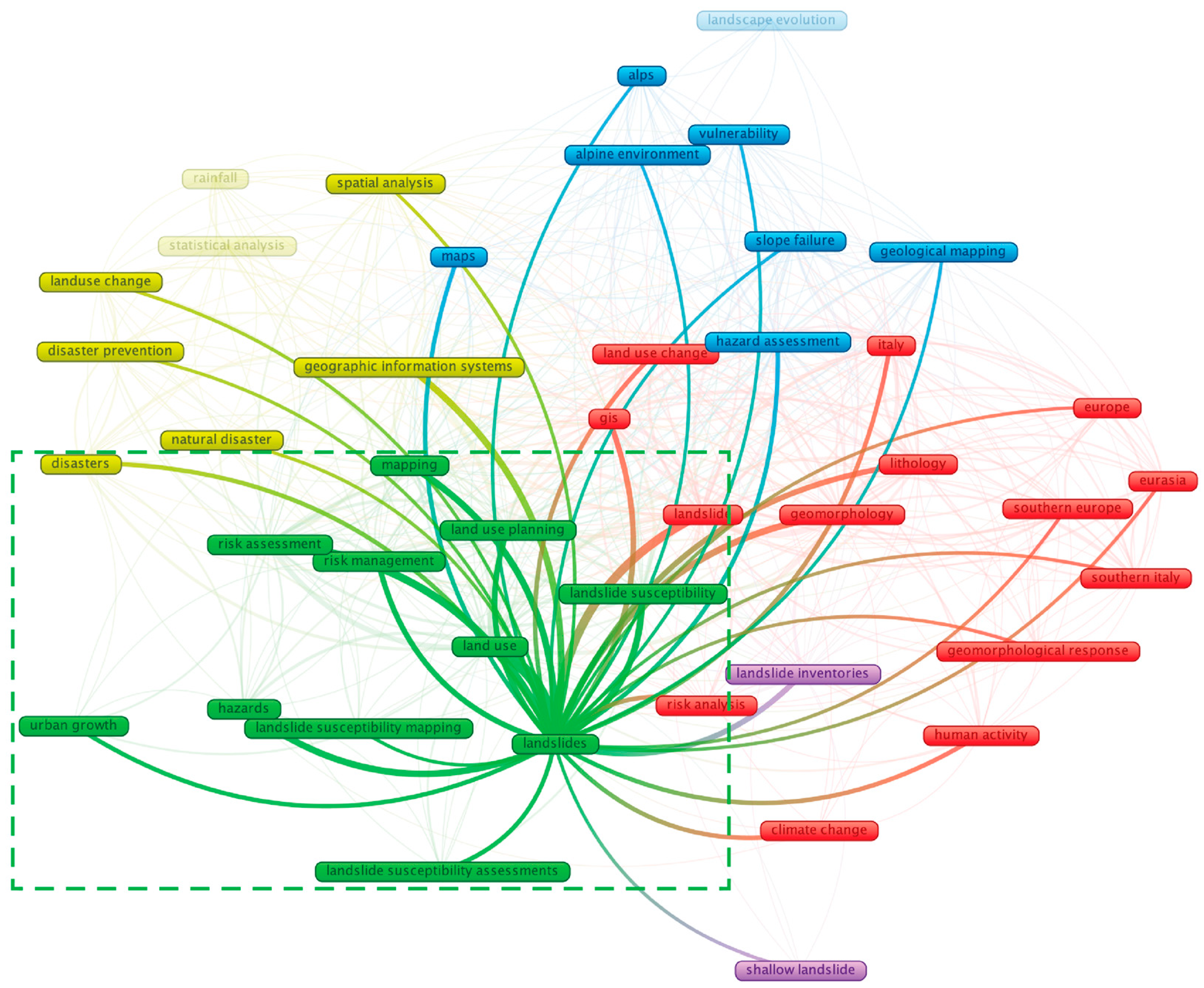
The second cluster (green colour) (Figure 8) included eleven items: hazards, land-use planning, land use, landslide susceptibility, landslide susceptibility assessment, landslide susceptibility mapping, landslides, mapping, risk assessment, risk management, and urban growth. The interconnectedness of keywords such as “landslides”, “risk assessment”, and “mapping” underscores the cluster’s focus on understanding and mitigating landslide risks within the context of urban development and spatial planning. The terms “landslides”, “landslide susceptibility mapping”, “risk management”, and “land use planning” demonstrate that research in this cluster is primarily concerned with identifying vulnerable areas and assessing risks to reduce landslide impacts through DRM and LUP, including “urban growth”, and “land use”, further emphasising the role of human intervention in landslide risks, particularly in rapidly urbanising regions.

4.2.2. Second Cluster Key Literature Detailed Review

The key literature in the second cluster (Table 2) shows that the emergence of AI, statistical modelling, and geospatial tools has significantly impacted landslide susceptibility assessment, with direct implications for LUP and DRM. To map landslide vulnerability, Rahaman et al. [76] implemented sustainable LUP and risk mitigation through geospatial methods with artificial neural networks, including several parameters like rainfall distribution, elevation, and slope direction, etc. Gyeltshen et al. [77] explore the combination of geospatial tools and statistical modelling to enhance community resilience. With an emphasis on statistical modelling and analysis, a Bayesian dynamic network is used to predict the geographical and temporal probability of a landslide happening [80]. Geospatial tools, combined with various risk modelling techniques, have a significant impact on LUP and DRM, as well as their broader applications in specific engineering fields.
Beyond risk modelling, several studies have examined the factors triggering landslides and the design of infrastructure in landslide-prone regions. Azarafza et al. [78] demonstrate that landslide susceptibility is triggered by multiple factors, not only climatology and geomorphology, but also human intervention and other geological hazards. Main infrastructure, including bridges, roads, and horse trails built in landslide-prone areas, requires appropriate principles to assess the built environment, encompassing both direct and indirect measures [79].

4.2.3. Second Cluster Future Direction

The second cluster integrated an artificial network model, geospatial techniques, and susceptibility assessment for LUP. Future research could focus on the emerging technologies to enhance landslide susceptibility prediction and real-time monitoring. Khalil [97] developed active landslide prevention strategies for mapping susceptibility, integrated with hybrid AI models. Conventional hazard analysis methods, such as manual assessment based on satellite imagery and geological survey, are frequently slow and less accurate [98]. In contrast, an ML-based model, which is automated for landslide detection, provides greater efficiency and precision, similar to a DL model [98,99,100]. Future LUP should consider susceptibility data for designated conservation and protected zones, optimising LUP based on varying risk levels [101]. Water and soil management are crucial, and hydrological modelling is becoming a more reliable tool for assessing sediments [102]. By integrating AI models and geo-spatial techniques, landslide susceptibility is expected to be highly effective and accurate, supporting LUP in the future.

4.3. Third Cluster (Yellow): Geospatial and Statistical Approach for Disaster Prevention

4.3.1. Third Cluster Key Literature Topic

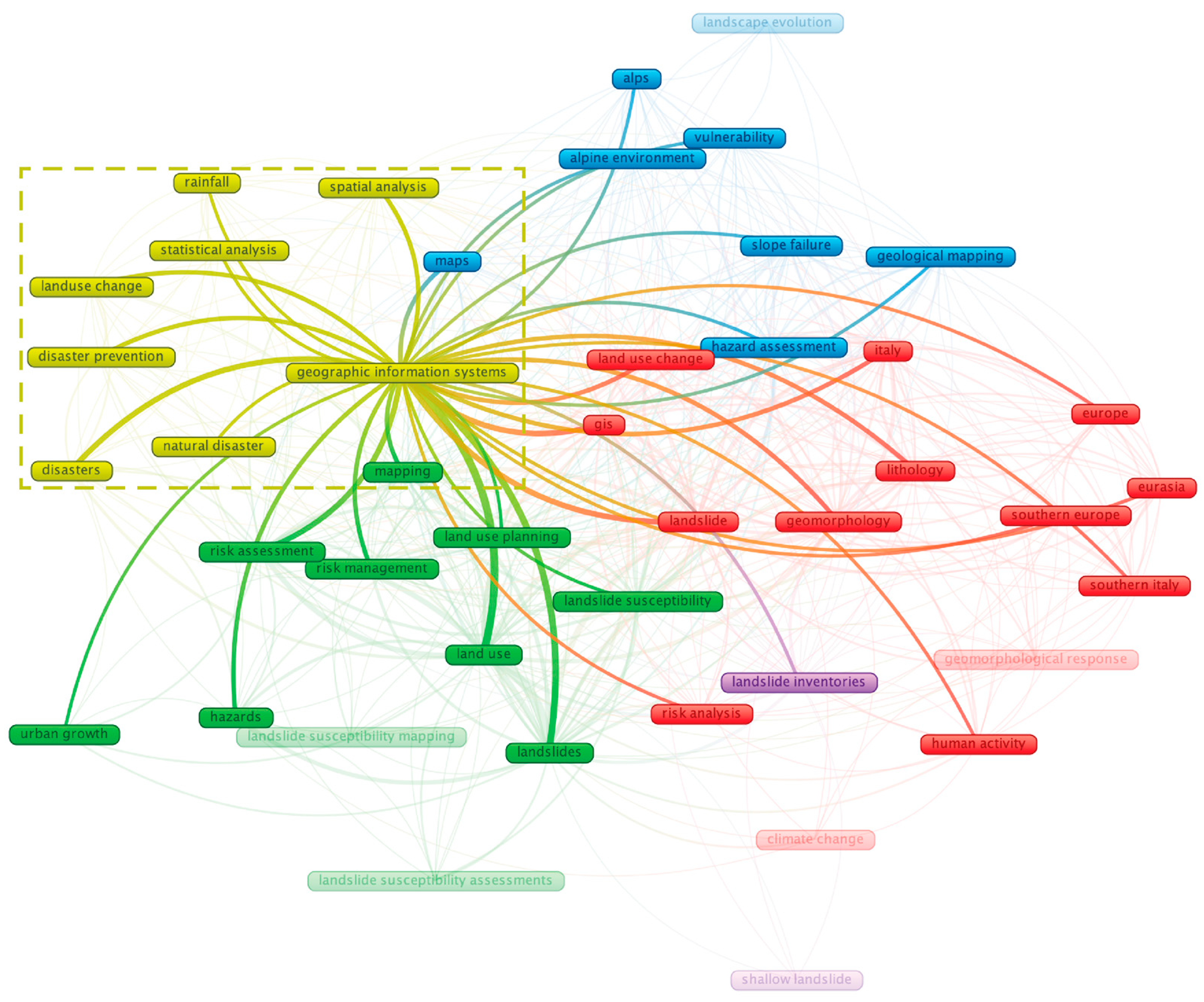
The third cluster (yellow colour) (Figure 9) included eight items: disaster prevention, disaster, geographic information systems, land-use change, natural disaster, rainfall, spatial analysis, and statistical analysis. The importance of terms such as “geographic information systems” is that research within this cluster uses geospatial technologies to develop predictive and analytical models for landslide risk assessment and prevention. The inclusion of “rainfall” and “land-use change” highlights the significant influence of hydrological processes and human activities on landslide management.

4.3.2. Third Cluster Key Literature Detailed Review

The key literature in the Third Cluster (Table 2) demonstrated that geological hazards have a significant impact on rapid urbanisation and LUP, emphasising the evaluation and management of the local regions. In this area, human activity has a significant impact, particularly geological catastrophes on land-use change, weather, and hydrology, including rainfall [81]. Rainfall is widely recognised as a key trigger factor for landslides in several studies. Peruccacci et al. [86] examine how landslides can be triggered by changes in rainfall conditions in various Italian environments. Meanwhile, landslide evaluation was separated into two parts by Wilopo et al. [85], namely, laboratory and field, considering the future land-use circumstances of forests, plantations, dry fields, and settlements. Quiquerez et al. [84] employ a multiproxy approach to replicate landscape change, linking it to the recolonisation of vegetation communities, social, and political factors after the landslide, which represents a significant shift in the land-use system.
Some research focuses on the local-scale prevention practices and management approaches. Thanveer et al. [82] and Prawiradisastra et al. [83] used different methods, hazard zonation mapping and landslide forensics assessment, to help multiple authorities make local regulations and policies for appropriate site selection and construction.

4.3.3. Third Cluster Future Direction

The third cluster utilised a geospatial and statistical approach for disaster prevention. Future research could explore spatial methods for disaster control and prevention across both early and long-term phases. Early warning systems are crucial for reducing risk in DRM, particularly in areas with limited internet connectivity [103]. To predict hazards, this system may be integrated with hydrological conditions and land-use dynamic change [104]. On a broader scale, a national-scale warning system based on a rainfall threshold which predicts the landslide [105]. Many landslides do not occur as a single event, but rather in several events, making accurate prediction challenging. Therefore, post-rock failure investigations are important for understanding failure mechanisms in DRM [106]. Additionally, environmental governance plays a key role in mitigating risk, enhancing geological hazard resilience and response capacity, and supporting regional development [107]. By understanding the limitations of different disaster phases, future research can better identify effective early warning and recovery strategies, contributing to a more resilient disaster prevention system.

4.4. Remaining Cluster

4.4.1. Remaining Cluster Key Literature Topic

The fourth cluster (blue colour) (Figure 10) included eight items: alpine environments, alps, geological mapping, hazard assessment, landscape evolution, maps, slope failure, and vulnerability. The keywords such as “alpine environment”, “slope failure”, “vulnerability”, and “geological mapping” in this cluster emphasise understanding landslide dynamics in high-altitude and geologically complex terrains. The terms “landscape evolution”, “hazard assessment”, and “maps” in this cluster analyse long-term geomorphological changes, assess landslide hazards, and develop spatial tools for DRM. The inclusion of “vulnerability” plays a role in shaping landslide risks in alpine regions.
The fifth cluster (purple colour) (Figure 10) included two items: landslide inventories and shallow landslides. The emphasis of a cluster is on documenting and studying landslide occurrences, particularly those involving shallow failure mechanisms. The centrality of landslide inventories suggests that research in this cluster is dedicated to compiling comprehensive datasets to analyse landslide and spatial distributions.

4.4.2. Remaining Cluster Key Literature Detailed Review

The following discussion refers to the key findings in the Fourth Cluster and Fifth Cluster (Table 2).
In mountainous regions, early warning systems and bioengineering are essential tools for LUP and DRM. At the local community level, Thapa et al. [87] utilised this method to help authorities promote policies and strategies for landslide risk mitigation, including forecasting, evacuation, and disaster response in the Nepalese mid-hill region. Similarly, in the Alpine region, Audisio et al. [88] employ a geospatial application to assess landslide susceptibility in LUP and risk management. By contrast, Magliulo et al. [89] assessed landslide susceptibility by using statistical methods in the geoenvironment. This highlights the need for precise LUP in the study area in order to minimise the occurrence of erosional processes.
Under the influence of climate change, high-resolution imagery and remote sensing have become increasingly important. To improve dataset reliability, Wood et al. [90] created a regional landslide inventory for the Alps. For planners and policymakers, the connection between landslides and climatology is an important initial step in forecasting the future. By processing and managing data through a GIS technique, both pre-, during-, and post-disaster, Borrelli et al. [91] offer an approach based on Google Earth photos; the tools could be utilised for landslide assessment and LUP.

4.4.3. Remaining Cluster Future Direction

The remaining clusters emphasise landslide inventories and hazard mapping in mountainous environments. Future research could focus on nature-based solutions for hazard mapping and understanding long-term landscape evolution. Integration of multi-scale warning methods, synthetic radar technology, and ML is anticipated to achieve real-time, high-precision warning capabilities [108,109], while constant landslide monitoring remains crucial for the development of sustainable infrastructure [110] and area conservation efforts [111]. Moreover, engineering solutions provide effective methods to control erosion processes and stabilisation in mountainous areas [112]. The spatial distribution of slope failure, documented through landslide inventories, offers insights for understanding long-term landscape evolution [113]. By synthesising nature-based solutions with landslide inventory databases, pre-disaster prediction and after-disaster adaptation can be significantly improved, contributing to more resilient regional planning and effective DRM.

5. Discussion

In this section, we describe the key findings of the review in response to the three research questions underpinning this study.
  • Can landslide research be applied in LUP to enhance broader DRM frameworks?
  • Does ecogeomorphological research play a role in fostering the development of risk-aware LUP?
  • What are the main ecogeomorphological factors that affect landslides in LUP?
Regarding the first research question, our review examined the various phases of landslide hazard, namely pre-, during, post-, and LUP approaches for mitigation. This included policy framework, risk modelling, zoning, and ecosystem-based solutions. Developing landslide mitigation plans may enhance the DRM framework, both locally by supporting communities and nationally by using emerging technologies [105]. Traditional geospatial platforms and technologies continue to be used as a foundation, such as GIS and remote sensing. However, AI, Big Data, IoT, and other technologies are already being applied in various phases of LUP and DRM. In the pre-disaster phase, an AI-generated early warning system can be developed for potential natural hazards [114]. During a disaster, a real-time AI-responsive platform provides an effective and precise decision-making process [115]. In a post-disaster phase, AI and big data analytics can measure the scale of disaster impact and organise the evacuation path to support the adaptive DRM [116].
To address the second research question, we structured the literature review using three dimensions: ecology, hydrology, and geomorphology. Some studies incorporated geomorphological and ecological perspectives to explain the cause of landslide risk and identify mitigation strategies based on terrain and vegetation-related elements [82,83,84]. Hydrological elements, especially rainfall patterns, emerged as critical bridging components between ecological and geomorphological dimensions, acting as landslide triggers [80,87]. The integration of ecogeomorphological study is increasingly acknowledged as an important condition for the development of risk-aware LUP.
Regarding the third research question, this literature review identified several key ecogeomorphological factors organised by three dimensions that affect landslide susceptibility and mitigation in LUP. The ecological dimension includes factors such as vegetation index, root cohesion, land cover type, biodiversity loss, etc. [76]. These are of critical importance because they influence slope stability and soil binding. The hydrological dimension includes rainfall distribution, drainage density, and surface runoff, etc.; these factors act as landslide triggers, especially in areas where water saturation alters slope mechanics, as evidenced by empirical rainfall thresholds [86]. The geomorphological dimension includes slope gradient, lithology, soil texture, and fault distance, etc. [77]. These define terrain susceptibility and influence spatial patterns and intensity of landslide hazards, particularly in mountainous regions.

5.1. Land-Use Planning (LUP)

Our semi-systematic review of selected articles reveals diverse existing approaches to LUP and landslide risk mitigation, which predominantly focus on the pre-disaster phase, while a lesser number of articles address the during-disaster and the post-disaster phases. In the pre-disaster phase, these approaches concentrate more on policy and regulatory framework, statistics and risk modelling, whereas during the disaster phase and the post-disaster phase, articles focus more on applied zoning and land classification, and ecosystem-based solutions (Table 3).
The most frequently adopted approach is statistics and risk modelling, which featured in many of the studies, highlighting its foundational role in land susceptibility mapping and hazard assessment. Especially emergent AI techniques, such as ML and DL [76,117]. Currently, the mainstream statistical modelling for landslide susceptibility mapping includes frequency ratio, power–law distribution, Bayesian dynamic networks, and so on [77,80,90].
Zoning and land classification are also widely applied, often used in tandem with risk modelling to inform development restrictions and different land type analyses. Many papers focus on land use, such as water bodies, urban areas, forests, etc. [71,81,117]. An increasing number of researchers focus on hazard conditioning factors, geomorphology, slope, and elevation [73,82]. Policy and regulatory frameworks are less frequently addressed, yet they form the essential governance principle that enables the implementation of strategy findings in practical LUP. Early warning systems are most often mentioned; however, cooperative multiple authorities are very important, enhancing the resilience of human communities [87]. A smaller but growing number of studies incorporate ecosystem-based solutions, emphasising the long-term ecological dimensions of hazard mitigation through nature-based strategies such as vegetation cover, bioengineering, and watershed management [84,91].
Ecosystem services have become an important tool in driving urban and landscape regeneration towards sustainability [118]. Unplanned land use poses significant threats to ecosystem services and human well-being [119]. A sustainable smart urban form provides a framework for incorporating green spaces and ecosystem services into urban planning and development [120], contributing to the improvement of urban ecological systems [121]. Strategic environmental assessment based on ecosystem services has been applied to LUP for agriculture development [122]. In addition, nature-based solutions have become a cutting-edge strategy that uses ecological resilience to reduce risks while also enhancing biodiversity and human welfare [123]. These solutions prevent environmental risks and ecological effects, providing adaptive methods for mitigating hazards [124]. Looking forward, ecosystem-based solutions hold great potential to integrate LUP, which can serve to advance hazard mitigation and leverage resilience for sustainable environmental management.
This distribution suggests an ongoing shift from purely technical risk assessment toward more integrated and adaptive planning approaches, acknowledging the role of governance and ecological resilience in shaping safe human habitats and sustainable local environments.

5.2. Ecogeomorphology

From an interdisciplinary viewpoint, ecogeomorphology is a more comprehensive field of study, which involves observing how microbes, plants, and animals affect the geomorphic process [18]. This article reveals a diverse but uneven integration of ecogeomorphological factors—namely geomorphological, hydrological, and ecological dimensions—across different studies and thematic clusters.
Among these ecogeomorphological factors, geomorphological dimensions, such as slope gradient, lithology, soil texture, and fault distance, etc., are the most considered elements in the reviewed articles. Hydrological dimensions, particularly rainfall distribution, drainage density, and surface runoff, etc., appear prominently in the second and third cluster. Ecological dimensions, such as vegetation index, root cohesion, land cover type, etc., are relatively underrepresented but are increasingly emphasised in the second and third clusters. A few papers consider these three dimensions simultaneously, such as studies that rely on different ecogeomorphological factors assessments for zoning and risk mapping, underscoring the foundational role of LUP in landslide mitigation.
Nonlinear interactions among biological and physical elements define ecogeomorphologic systems, resulting in the formation of landforms and vegetation patterns [125,126]. By utilising abiotic and biotic feedback mechanisms, these systems enhance the protective function of vegetation in reducing soil erosion and surface processes [127]. P. M. Saco et al. [128] demonstrate the feedback loop produced by the interaction between vegetation and hydrological processes, soil moisture promotes plant development, which in turn affects the distribution of water locally. Topographic variables, such as the hillslope aspect, further modulate the distribution of vegetation by solar radiation and microclimatic conditions [129]. From a holistic perspective, the critical zone, particularly the shallow fractured bedrock, plays a key role in regulating ecosystem dynamics through interactions between soil, vegetation, and water [130]. Organisms within the Earth’s critical zone actively contribute to landscape evolution through their influence on geochemical, hydrological, and geomorphological processes [131].
Overall, the findings suggest that while geomorphological and hydrological considerations dominate current land-use strategies, there is an emerging trend toward incorporating ecological resilience, especially in more recent publications, indicating a shift toward integrated, ecogeomorphological approaches in LUP for landslide-prone regions.

5.3. Research Gaps/Future Research Questions

The identification of research gaps offers an opportunity to extend this ecogeomorphological framework beyond theoretical analysis to practical application. One crucial direction is the exploration of practice-oriented implementations of ecogeomorphological principles. The integration of geomorphology and environment provides the dynamic of geodiversity and biodiversity [132].
The term “practice” in this context invites a broader understanding of what it involves: (1) Encompass governmental spatial planning, where risk assessment and environmental resilience are integrated into policy and zoning [133]; (2) On-site engineering practices, which adapt slope stabilisation and hydrological control to geomorphological characteristics [134]; (3) A new form of ecogeomorphological design, which would emphasise adaptability, resilience, and co-existence with natural hazards. The development of a design practice would mean bringing an ecogeomorphological approach into the spatial planning and design scales, where design is a strategic tool to harmonise human habitats with natural hazard risks. This could include adaptive green infrastructures [135,136], ecosystem-based solutions [137,138], and hazard-aware land-use strategies [139], which anticipate environmental changes and mitigate risks proactively.
The following four possible future research directions emerged from our review:
  • Identification of the different types of ecogeomorphological factors that shape LUP in each local context.
  • Development of an integrated methodological framework that can capture synergies between ecological, hydrological, and geomorphological dimensions for DRM.
  • Examination of how ecological, hydrological, and geomorphological data can be better integrated into a unified framework for LUP and hazard mitigation.
  • Identification of the authorities and governance barriers that limit the implementation of ecogeomorphologically informed LUP.
In reference to the first future research direction, the existing literature shows that geomorphological and ecological processes influence LUP. However, there is a lack of systematic understanding of the specific types of ecogeomorphological factors involved and how important they are across contexts. These factors may include topographic gradients, soil stability, vegetation cover, and drainage networks. The diverse ecological and geomorphological conditions in different regions demand a locally adapted planning response. Future research could contribute by categorising these factors and their interaction in various local environments, using AI techniques to collect and analyse different influencing factors. This could be further enhanced with text-based methods in local weather contexts, historical hazard records, local building damage assessments and so on to provide a comprehensive ecogeomorphological investigation and thereby support evidence-based and site-specific planning strategies.
The second possible future research direction is based on the observation that despite recognition of the interdependence between ecological, hydrological, and geomorphological considerations, current planning methods barely represent these synergies in the analytic framework and DRM. The scope includes interdisciplinary integration, particularly between earth science and planning practice. Research in this area could contribute by developing spatial analysis tools, computational models, and dynamically representing such synergies. Moreover, the emerging geospatial tools applied in this framework, especially pre-disaster and post-disaster in further studies, through the integration of ML and IoT, would support decision-making quickly and effectively. The multi-sensor performance of IoT environment assessment would further enhance ecogeomorphological investigation.
Regarding the third possible research direction, although various data within the environmental system were identified, databases are often fragmented across disciplines and scales, making it difficult to integrate them into a planning-oriented framework. For land-use planners and decision-makers, the gap here is in the integration of multi-source, multi-scale data from satellite imaging, GIS data, hydrological models, ecological field observation, etc. The extent of this challenge lies not just in integrating technical data, but also in methodological harmonisation and standardisation. Future research could contribute to this field by proposing an SDI system, through ML techniques in harvesting data, based on spatial-temporal datasets, specific types of hazards, location and date, integrating these as accessible and interoperable tools that enhance proactive local hazard mitigation and spatial decision-making.
Finally, the fourth direction that could inform future research activities is based on the observation that even with the scientific knowledge and technical tools available, the translation of ecogeomorphological insights into planning practice remains limited by authorities and governance-related barriers. These may include a lack of cross-sectoral communication, an inadequate regulatory framework, or low awareness of ecogeomorphological approaches among decision-makers. Investigating these barriers could reveal structural limitations within the current governance system and offer suggestions for reforming it. Research in this domain should explore the limitations of data sharing, understand ecogeomorphological-related data, and integrate SDI, which would enable a multi-authority governance system. This approach should incorporate mixed methods to inform the design of participatory governance models, policy integration, and public engagement that better facilitate planning practices.
Overall, this research points to the need for the development of a semi-systematic conceptual and methodological framework for a clearly defined ecogeomorphological approach to LUP that emphasises the integration of ecological, geomorphological, and hydrological dimensions for natural hazard risk mitigation with a particular focus on landslide risks. This requires that land that is characterised by such risks can still be used as a living place for humans based on planning that minimises the risk for human life, the environment, and local ecosystems.

Author Contributions

Conceptualisation, Z.Z. and M.H.; methodology, Z.Z. and J.T.; validation, Z.Z., M.H. and J.T.; formal analysis, Z.Z.; investigation, Z.Z.; writing—original draft preparation, Z.Z., M.H. and J.T.; writing—review and editing, Z.Z., M.H. and J.T.; visualisation, Z.Z.; supervision, M.H.; All authors have read and agreed to the published version of the manuscript.

Funding

This research was funded by TU Wien Bibliothek, Open Access Funding Programme.

Data Availability Statement

The dataset supporting this study includes the full list of 827 articles initially screened and a final selection of 26 articles used in the literature review. The dataset, including metadata and classification labels, is openly available in Zenodo at https://doi.org/10.5281/zenodo.15323463.

Acknowledgments

The authors acknowledge TU Wien Bibliothek for financial support through its Open Access Funding Programme, and for additional support for editing and proofreading services.

Conflicts of Interest

The authors declare no conflicts of interest.

References

  1. Tebbens, S.F. Landslide Scaling: A Review. Earth Space Sci. 2020, 7, e2019EA000662. [Google Scholar] [CrossRef]
  2. Cruden, D. A simple definition of a landslide. Bull. Int. Assoc. Eng. Geol. Bull. de L’association Int. de Géologie de L’ingénieur 1991, 43, 27–29. [Google Scholar] [CrossRef]
  3. Causes, L. Landslide Types and Processes; US Geological Survey: Reston, VA, USA, 2001. [Google Scholar]
  4. Dai, F.C.; Lee, C.F.; Ngai, Y.Y. Landslide risk assessment and management: An overview. Eng. Geol. 2002, 64, 65–87. [Google Scholar] [CrossRef]
  5. Thoms, M.; Parsons, M. Eco-Geomorphology: An Interdisciplinary Approach to River Science; IAHS-AISH Publication: Wallingford, UK, 2002; Volume 276. [Google Scholar]
  6. Barbier, N.; Bellot, J.; Couteron, P.; Parsons, A.; Paton Née Mueller, E. Short-Range Ecogeomorphic Processes in Dryland Systems; Springer: Berlin/Heidelberg, Germany, 2014. [Google Scholar]
  7. Moeslund, J.E.; Arge, L.; Bøcher, P.K.; Dalgaard, T.; Svenning, J.-C. Topography as a driver of local terrestrial vascular plant diversity patterns. Nord. J. Bot. 2013, 31, 129–144. [Google Scholar] [CrossRef]
  8. Li, J.; Yang, L.; Pu, R.; Liu, Y. A review on anthropogenic geomorphology. J. Geogr. Sci. 2017, 27, 109–128. [Google Scholar] [CrossRef]
  9. Price, K. Effects of watershed topography, soils, land use, and climate on baseflow hydrology in humid regions: A review. Prog. Phys. Geogr. 2011, 35, 465–492. [Google Scholar] [CrossRef]
  10. Cowles, H.C. The Ecological Relations of the Vegetation on the Sand Dunes of Lake Michigan. Part I.—Geographical Relations of the Dune Floras. Bot. Gaz. 1899, 27, 95–117. [Google Scholar] [CrossRef]
  11. Olson, J.S. Lake Michigan Dune Development Plants as Agents and Tools in Geomorphology. J. Geol. 1958, 66, 345–351. [Google Scholar] [CrossRef]
  12. Osterkamp, W.R.; Hupp, C.R.; Schening, M.R. Little River revisited—Thirty-five years after Hack and Goodlett. In Biogeomorphology, Terrestrial and Freshwater Systems; Hupp, C.R., Osterkamp, W.R., Howard, A.D., Eds.; Elsevier: Amsterdam, The Netherlands, 1995; pp. 1–20. [Google Scholar]
  13. Wheaton, J.M.; Gibbins, C.; Wainwright, J.; Larsen, L.; McElroy, B. Preface: Multiscale Feedbacks in Ecogeomorphology. Geomorphology 2011, 126, 265–268. [Google Scholar] [CrossRef]
  14. Reinhardt, L.; Jerolmack, D.; Cardinale, B.J.; Vanacker, V.; Wright, J. Dynamic interactions of life and its landscape: Feedbacks at the interface of geomorphology and ecology. Earth Surf. Process. Landf. 2010, 35, 78–101. [Google Scholar] [CrossRef]
  15. Naylor, L.A.; Viles, H.A.; Carter, N.E.A. Biogeomorphology revisited: Looking towards the future. Geomorphology 2002, 47, 3–14. [Google Scholar] [CrossRef]
  16. Corenblit, D.; Corbara, B.; Steiger, J. Biogeomorphological eco-evolutionary feedback between life and geomorphology: A theoretical framework using fossorial mammals. Sci. Nat. 2021, 108, 55. [Google Scholar] [CrossRef] [PubMed]
  17. Eichel, J.; Corenblit, D.; Dikau, R. Conditions for feedbacks between geomorphic and vegetation dynamics on lateral moraine slopes: A biogeomorphic feedback window. Earth Surf. Process. Landf. 2016, 41, 406–419. [Google Scholar] [CrossRef]
  18. Viles, H.A. Biogeomorphology. In The History of the Study of Landforms or the Development of Geomorphology: Geomorphology in the Second Half of the Twentieth Century; Burt, T.P., Goudie, A.S., Viles, H.A., Eds.; Geological Society of London: London, UK, 2022; Volume 5. [Google Scholar]
  19. Mueller, E.N.; Wainwright, J.; Parsons, A.J.; Turnbull, L. Land Degradation in Drylands: An Ecogeomorphological Approach. In Patterns of Land Degradation in Drylands: Understanding Self-Organised Ecogeomorphic Systems; Mueller, E.N., Wainwright, J., Parsons, A.J., Turnbull, L., Eds.; Springer Netherlands: Dordrecht, The Netherlands, 2014; pp. 1–9. [Google Scholar]
  20. Ghosh, S.; Hoque, M.; Saha, U.; Islam, A. Assessment of dam-induced changes in ecogeomorphological behaviour and fluvial functionality in the Damodar River, West Bengal, India. J. Water Supply Res. Technol. Aqua 2022, 71, 722–750. [Google Scholar] [CrossRef]
  21. Kazemi, A.; Moghaddam, M.; Khezri, S. Ecogeomorphological Condition and Hydrological Indicators of the Self-Purification Capacity of Rivers: A Case Study of Siminehrood River in Northwestern Iran. Int. J. Environ. Health Eng. 2023, 12, 5. [Google Scholar] [CrossRef]
  22. O’Briain, R.; Corenblit, D.; Garófano Gómez, V.; O’Leary, C. Towards biogeomorphic river restoration: Vegetation as a critical driver of physical habitat. River Res. Appl. 2024, 40, 1087–1105. [Google Scholar] [CrossRef]
  23. Uzun, A.; Erciyas Yavuz, K.; Karaer, F.; Polat, N.; Bakan, G.; Gürgöze, S. Ecogeomorphological Investigation of Anthropogenic Changes in the Kızılırmak River Mouth, Türkiye. Wetlands 2024, 44, 83. [Google Scholar] [CrossRef]
  24. Poufarashzadeh, F.; Madadi, A.; Gharachorlu, M.; Sareskanrood, S. Spatial-statistical modelling of deforestation from an ecogeomorphic perspective in typical Hyrcanian forests, northern Iran. Environ. Monit. Assess. 2025, 197, 324. [Google Scholar] [CrossRef]
  25. Solaimani, K.; Darvishi, S. Comparative analysis of land use changes modelling based-on new hybrid models and CA-Markov in the Urmia lake basin. Adv. Space Res. 2024, 74, 3749–3764. [Google Scholar] [CrossRef]
  26. Turner, B.L.; Lambin, E.F.; Reenberg, A. The emergence of land change science for global environmental change and sustainability. Proc. Natl. Acad. Sci. USA 2007, 104, 20666–20671. [Google Scholar] [CrossRef]
  27. Roy, F.; Ferland, Y. Land-use planning for disaster risk management. Land. Tenure J. 2015, 2014, 70–103. [Google Scholar]
  28. Saunders, W.; Beban, J.G.; Kilvington, M. Risk-based land use planning for natural hazard risk reduction. GNS Sci. Misc. Ser. 2013, 67, 97. [Google Scholar]
  29. Falasca, F.; Sette, C.; Montaldi, C. Addressing land use planning: A methodology for assessing pre- and post-landslide event urban configurations. Sci. Total Environ. 2024, 921, 171152. [Google Scholar] [CrossRef]
  30. Barton, H. Land use planning and health and well-being. Land Use Policy 2009, 26, S115–S123. [Google Scholar] [CrossRef]
  31. Metternicht, G. Land Use and Spatial Planning: Enabling Sustainable Management of Land Resources; Springer: Berlin/Heidelberg, Germany, 2018. [Google Scholar]
  32. Silberstein, M.; Maser, C. Land-Use Planning for Sustainable Development; CRC Press: Boca Raton, FL, USA, 2013. [Google Scholar]
  33. Rohrmann, B.; Renn, O. Risk perception research: An introduction. In Cross-Cultural Risk Perception: A Survey of Empirical Studies; Springer: Berlin/Heidelberg, Germany, 2000; pp. 11–53. [Google Scholar]
  34. Wachinger, G.; Renn, O. Risk Perception and Natural Hazards. CapHaz-Net WP3 Report, DIALOGIK Non-Profit Institute for Communication and Cooperative Research, Stuttgart. 2010. Available online: https://giam.zrc-sazu.si/sites/default/files/caphaz-net_wp3_risk-perception2.pdf (accessed on 15 September 2025).
  35. Sutanta, H.; Rajabifard, A.; Bishop, I.D. Disaster risk reduction using acceptable risk measures for spatial planning. J. Environ. Plan. Manag. 2013, 56, 761–785. [Google Scholar] [CrossRef]
  36. Godber, A. Urban floodplain land-use–acceptable risk? Aust. J. Emerg. Manag. 2005, 20, 22–26. [Google Scholar]
  37. Renn, O.; Klinke, A. A framework of adaptive risk governance for urban planning. Sustainability 2013, 5, 2036–2059. [Google Scholar] [CrossRef]
  38. Rezvani, S.M.; Falcão, M.J.; Komljenovic, D.; de Almeida, N.M. A systematic literature review on urban resilience enabled with asset and disaster risk management approaches and GIS-based decision support tools. Appl. Sci. 2023, 13, 2223. [Google Scholar] [CrossRef]
  39. Burby, R.; Deyle, R.; Godschalk, D.; Olshansky, R. Creating Hazard Resilient Communities through Land-Use Planning. Nat. Hazards Rev. 2000, 1, 99–106. [Google Scholar] [CrossRef]
  40. Ravanashree, M.; Baskar, P.; Mohan, L.; Janani, N.; Kathirvel, L.; Ramachandiran, P.; Aakash, S. The Role of Google Earth Engine in Flood Disaster Management: A Review of Capabilities and Challenges. Adv. Environ. Res. 2025, 26, 472–479. [Google Scholar]
  41. Waleed, M.; Sajjad, M. On the emergence of geospatial cloud-based platforms for disaster risk management: A global scientometric review of google earth engine applications. Int. J. Disaster Risk Reduct. 2023, 97, 104056. [Google Scholar] [CrossRef]
  42. Dai, D.; Bo, M.; Ren, X.; Dai, K. Application and exploration of artificial intelligence technology in urban ecosystem-based disaster risk reduction: A scoping review. Ecol. Indic. 2024, 158, 111565. [Google Scholar] [CrossRef]
  43. Bail, R.d.F.; Kovaleski, J.L.; da Silva, V.L.; Pagani, R.N.; Chiroli, D.M.d.G. Internet of things in disaster management: Technologies and uses. Environ. Hazards 2021, 20, 493–513. [Google Scholar] [CrossRef]
  44. Wang, C.; Gao, Y.; Aziz, A.; Ogunmola, G.A. Agricultural disaster risk management and capability assessment using big data analytics. Big Data 2022, 10, 246–261. [Google Scholar] [CrossRef]
  45. Abid, S.K.; Sulaiman, N.; Chan, S.W.; Nazir, U.; Abid, M.; Han, H.; Ariza-Montes, A.; Vega-Muñoz, A. Toward an Integrated Disaster Management Approach: How Artificial Intelligence Can Boost Disaster Management. Sustainability 2021, 13, 12560. [Google Scholar] [CrossRef]
  46. Sönmez, N.; Tokdemir, O.B.; Günaydın, H.M. Artificial Intelligence in Earthquake Disaster Risk Management: A Systematic Review of Applications, Challenges, and Research Gaps. In Intelligent and Fuzzy Systems; Springer: Berlin/Heidelberg, Germany, 2025; pp. 791–807. [Google Scholar]
  47. Aljohani, F.H.; Abi Sen, A.A.; Ramazan, M.S.; Alzahrani, B.; Bahbouh, N.M. A Smart Framework for Managing Natural Disasters Based on the IoT and ML. Appl. Sci. 2023, 13, 3888. [Google Scholar] [CrossRef]
  48. Velev, D.; Zlateva, P. Challenges of artificial intelligence application for disaster risk management. Int. Arch. Photogramm. Remote Sens. Spat. Inf. Sci. 2023, 48, 387–394. [Google Scholar] [CrossRef]
  49. Zêzere, J.; Reis, E.; Garcia, R.; Oliveira, S.; Rodrigues, M.L.; Vieira, G.; Ferreira, A. Integration of spatial and temporal data for the definition of different landslide hazard scenarios in the area north of Lisbon (Portugal). Nat. Hazards Earth Syst. Sci. 2004, 4, 133–146. [Google Scholar] [CrossRef]
  50. Tsoutsos, M.-C.; Vescoukis, V. Natural Hazards and Spatial Data Infrastructures (SDIs) for Disaster Risk Reduction. Eng. Proc. 2025, 87, 101. [Google Scholar]
  51. Li, H.; Liu, J.; Zhou, X. Intelligent Map Reader: A Framework for Topographic Map Understanding with Deep Learning and Gazetteer. IEEE Access 2018, 6, 25363–25376. [Google Scholar] [CrossRef]
  52. Bhatti, U.A.; Yu, Z.; Yuan, L.; Zeeshan, Z.; Nawaz, S.A.; Bhatti, M.; Mehmood, A.; Ain, Q.U.; Wen, L. Geometric Algebra Applications in Geospatial Artificial Intelligence and Remote Sensing Image Processing. IEEE Access 2020, 8, 155783–155796. [Google Scholar] [CrossRef]
  53. Nugroho, Y.S.; Supangkat, S.H. Spatial Data Infrastructure Integrated with Geospatial Artificial Intelligence: A Systematic Literature Review. In Proceedings of the 2021 International Conference on ICT for Smart Society (ICISS), Bandung, Indonesia, 2–4 August 2021; pp. 1–5. [Google Scholar]
  54. Wong, G.; Greenhalgh, T.; Westhorp, G.; Buckingham, J.; Pawson, R. RAMESES publication standards: Meta-narrative reviews. BMC Med. 2013, 11, 20. [Google Scholar] [CrossRef]
  55. Snyder, H. Literature review as a research methodology: An overview and guidelines. J. Bus. Res. 2019, 104, 333–339. [Google Scholar] [CrossRef]
  56. Braun, V.; Clarke, V. Using thematic analysis in psychology. Qual. Res. Psychol. 2006, 3, 77–101. [Google Scholar] [CrossRef]
  57. King, W.; He, J. Understanding the Role and Methods of Meta-Analysis in IS Research. Commun. Ais CAIS 2006, 16, 32. [Google Scholar] [CrossRef]
  58. Sylvester, A.; Tate, M.; Johnstone, D. Beyond synthesis: Re-presenting heterogeneous research literature. Behav. Inf. Technol. Behav. IT 2011, 32, 1199–1215. [Google Scholar] [CrossRef]
  59. Hirt, J.; Nordhausen, T.; Appenzeller-Herzog, C.; Ewald, H. Using citation tracking for systematic literature searching—Study protocol for a scoping review of methodological studies and a Delphi study [version 2; peer review: 2 approved with reservations]. F1000Research 2021, 9, 1386. [Google Scholar] [CrossRef] [PubMed]
  60. Pare, G.; Trudel, M.-C.; Jaana, M.; Kitsiou, S. Synthesizing Information Systems Knowledge: A Typology of Literature Reviews. Inf. Manag. 2015, 52, 183–199. [Google Scholar] [CrossRef]
  61. Harb, Y.; Abu-Shanab, E. A descriptive framework for the field of knowledge management. Knowl. Inf. Syst. 2020, 62, 4481–4508. [Google Scholar] [CrossRef]
  62. Bukar, U.A.; Sayeed, M.S.; Razak, S.F.A.; Yogarayan, S.; Amodu, O.A.; Mahmood, R.A.R. A method for analyzing text using VOSviewer. MethodsX 2023, 11, 102339. [Google Scholar] [CrossRef]
  63. Rohrmann, B. Risk perception, risk attitude, risk communication, risk management: A conceptual appraisal. In Proceedings of the 15th Internaional Emergency Management Society (TIEMS) Annual Conference, Prague, Czech Republic, 17–19 June 2008. [Google Scholar]
  64. Ahsan, D.A. Farmers’ motivations, risk perceptions and risk management strategies in a developing economy: Bangladesh experience. J. Risk Res. 2011, 14, 325–349. [Google Scholar] [CrossRef]
  65. van Eck, N.J.; Waltman, L. Visualizing Bibliometric Networks. In Measuring Scholarly Impact: Methods and Practice; Ding, Y., Rousseau, R., Wolfram, D., Eds.; Springer International Publishing: Cham, Switzerland, 2014; pp. 285–320. [Google Scholar]
  66. Stallins, J.A. Geomorphology and ecology: Unifying themes for complex systems in biogeomorphology. Geomorphology 2006, 77, 207–216. [Google Scholar] [CrossRef]
  67. Keller, E.; Adamaitis, C.; Alessio, P.; Anderson, S.; Goto, E.; Gray, S.; Gurrola, L.; Morell, K. Applications in geomorphology. Geomorphology 2020, 366, 106729. [Google Scholar] [CrossRef]
  68. Zamora, N.J. The landslide hazard map of bogota an updating. In Proceedings of the International Archives of the Photogrammetry, Remote Sensing and Spatial Information Sciences—ISPRS Archives, Karisruhe, Germany, 10–12 October 2018; pp. 233–241. [Google Scholar]
  69. Bozicek, B.; Koren, E. Management of Landslides in Small Settlements in Slovenia. In Advancing Culture of Living with Landslides; Advances in Landslide Science; Springer: Berlin/Heidelberg, Germany, 2017; Volume 2, pp. 989–998. [Google Scholar]
  70. Oppikofer, T.; Nordahl, B.; Bunkholt, H.; Nicolaisen, M.; Jarna, A.; Iversen, S.; Hermanns, R.L.; Böhme, M.; Molina, F.X.Y. Database and online map service on unstable rock slopes in Norway—From data perpetuation to public information. Geomorphology 2015, 249, 69–81. [Google Scholar] [CrossRef]
  71. Bruschi, V.M.; Bonachea, J.; Remondo, J.; Gómez-Arozamena, J.; Rivas, V.; Barbieri, M.; Capocchi, S.; Soldati, M.; Cendrero, A. Land management versus natural factors in land instability: Some examples in northern Spain. Environ. Manag. 2013, 52, 398–416. [Google Scholar] [CrossRef]
  72. Sanders, M.H. Geomorphology: Processes, Taxonomy and Applications; Nova Science Publishers, Inc.: Hauppauge, NY, USA, 2013; pp. 1–215. [Google Scholar]
  73. Coutinho, R.; Pacheco, J.; Wallenstein, N.; Pimentel, A.; Marques, R.; Silva, R. Integrating geological knowledge in planning methods for small islands coastal plans. J. Coast. Res. 2009, 2, 1199–1203. [Google Scholar]
  74. Restrepo, C.; Walker, L.R.; Shiels, A.B.; Bussmann, R.; Claessens, L.; Fisch, S.; Lozano, P.; Negi, G.; Paolini, L.; Poveda, G.; et al. Landsliding and Its Multiscale Influence on Mountainscapes. Bioscience 2009, 59, 685–698. [Google Scholar] [CrossRef]
  75. Capolongo, D.; Pennetta, L.; Piccarreta, M.; Fallacara, G.; Boenzi, F. Spatial and temporal variations in soil erosion and deposition due to land-levelling in a semi-arid area of Basilicata (Southern Italy). Earth Surf. Process. Landf. 2008, 33, 364–379. [Google Scholar] [CrossRef]
  76. Rahaman, A.; Dondapati, A.; Gupta, S.; Raj, R. Leveraging artificial neural networks for robust landslide susceptibility mapping: A geospatial modelling approach in the ecologically sensitive Nilgiri District, Tamil Nadu. Geohazard Mech. 2024, 2, 258–269. [Google Scholar] [CrossRef]
  77. Gyeltshen, S.; Chhetri, I.B.; Dema, K. Evaluation of statistical modelling (SM) approaches for landslide susceptibility mapping: Geospatial insights for Bhutan. Environ. Earth Sci. 2024, 83, 1–20. [Google Scholar] [CrossRef]
  78. Azarafza, M.; Ghazifard, A.; Akgün, H.; Asghari-Kaljahi, E. Landslide susceptibility assessment of South Pars Special Zone, southwest Iran. Environ. Earth Sci. 2018, 77, 805. [Google Scholar] [CrossRef]
  79. Popescu, M.E.; Trandafir, A.C. Landslide risk assessment and mitigation. In Bridge Engineering Handbook, 2nd ed.; Substructure Design; CRC Press: Boca Raton, FL, USA, 2014; pp. 315–359. [Google Scholar]
  80. Sandric, I.; Chitu, Z. Landsat Time Series Analysis for Modelling Temporal Probability for Landslide Occurrences in Curvature Subcarpathians, Romania. In Proceedings of the GI_FORUM 2013: Creating the Gisociety, Salzburg, Austria, 2–5 July 2013; pp. 165–168. [Google Scholar]
  81. Xin, Z.; Xiaoyu, Z.; Hao, L.; Chenyi, Z.; Zhile, S.; Lijun, J.; Zelin, W.; Zheng, F.; Jiayang, Y.; Xin, Y.; et al. The relationship between geological disasters with land use change, meteorological and hydrological factors: A case study of Neijiang City in Sichuan Province. Ecol. Indic. 2023, 154, 110840. [Google Scholar] [CrossRef]
  82. Thanveer, C.T.A.; Mohammed, H.; Puthuvathara, A.I.; Dilruba, P.M.; Rajalakshmi, T.R. Landslide Hazard Zonation of Peerumedu Taluk Using ArcGIS. In Lecture Notes in Civil Engineering; Springer: Berlin/Heidelberg, Germany, 2023; pp. 1139–1153. [Google Scholar]
  83. Prawiradisastra, F.; Shomim, A.F.; Trisnafiah, S.; Khaerani, P.; Tejakusuma, I.G.; Zakaria, Z. Forensic assessment of landslides induced by environmental changes in Sumedang, Indonesia, an important step for the future disaster prevention. In IOP Conference Series: Earth and Environmental Science; IOP Science: Bristol, UK, 2023. [Google Scholar]
  84. Quiquerez, A.; Gauthier, E.; Bichet, V.; Petit, C.; Murgia, L.; Richard, H. Reconstructing patterns of vegetation recovery and landscape evolution after a catastrophic landslide (Mont Granier, French Alps, 1248 CE). Anthropocene 2022, 40, 100352. [Google Scholar] [CrossRef]
  85. Wilopo, W.; Erzagian, E.; Ratri, D.; Fathani, T.F. Landslide Susceptibility Assessment in Trenggalek, East Java, Indonesia: A Geological Overview. In Lecture Notes in Civil Engineering; Springer: Berlin/Heidelberg, Germany, 2021; pp. 873–883. [Google Scholar]
  86. Peruccacci, S.; Brunetti, M.T.; Gariano, S.L.; Melillo, M.; Rossi, M.; Guzzetti, F. Rainfall thresholds for possible landslide occurrence in Italy. Geomorphology 2017, 290, 39–57. [Google Scholar] [CrossRef]
  87. Thapa, P.S.; Adhikari, B.R.; Shaw, R.; Bhattarai, D.; Yanai, S. Geomorphological analysis and early warning systems for landslide risk mitigation in Nepalese mid-hills. Nat. Hazards 2023, 117, 1793–1812. [Google Scholar] [CrossRef]
  88. Audisio, C.; Nigrelli, G.; Pasculli, A.; Sciarra, N.; Turconi, L. A GIS spatial analysis model for landslide hazard mapping application in Alpine Area. Int. J. Sustain. Dev. Plan. 2017, 12, 883–893. [Google Scholar] [CrossRef]
  89. Magliulo, P.; Di Lisio, A.; Russo, F.; Zelano, A. Geomorphology and landslide susceptibility assessment using GIS and bivariate statistics: A case study in southern Italy. Nat. Hazards 2008, 47, 411–435. [Google Scholar] [CrossRef]
  90. Wood, J.L.; Harrison, S.; Reinhardt, L. Landslide inventories for climate impacts research in the European Alps. Geomorphology 2015, 228, 398–408. [Google Scholar] [CrossRef]
  91. Borrelli, L.; Cofone, G.; Coscarelli, R.; Gullà, G. Shallow landslides triggered by consecutive rainfall events at Catanzaro strait (Calabria–Southern Italy). J. Maps 2015, 11, 730–744. [Google Scholar] [CrossRef]
  92. Gares, P.A.; Sherman, D.J.; Nordstrom, K.F. Geomorphology and natural hazards. Geomorphology 1994, 10, 1–18. [Google Scholar] [CrossRef]
  93. Cuervas-Mons, J.; Domínguez-Cuesta, M.J.; Jiménez-Sánchez, M. Potential and Limitations of the New European Ground Motion Service in Landslides at a Local Scale. Appl. Sci. 2024, 14, 7796. [Google Scholar] [CrossRef]
  94. Riaz, A.; Nijhuis, S.; Bobbink, I. The Role of Spatial Planning in Landscape-Based Groundwater Recharge: A Systematic Literature Review. Water 2025, 17, 862. [Google Scholar] [CrossRef]
  95. Qiu, H.; Wei, Y. Landslide Geomorphology: Pattern, Process and Stability. J. Earth Sci. 2025, 36, 327–332. [Google Scholar] [CrossRef]
  96. Regmi, N.R.; Walter, J.I. Detailed mapping of shallow landslides in eastern Oklahoma and western Arkansas and potential triggering by Oklahoma earthquakes. Geomorphology 2020, 366, 106806. [Google Scholar] [CrossRef]
  97. Khalil, A. Utilizing Hybrid Machine Learning and Soft Computing Techniques for Landslide Susceptibility Mapping in a Drainage Basin. Water 2024, 16, 380. [Google Scholar] [CrossRef]
  98. Deepa Priya, V.; Shah, S.; Praveen, L.; Rajesh, R.M. Deep Learning Model for Automated Landslide and Debris Flow Detection. Int. Res. J. Adv. Eng. Hub (IRJAEH) 2025, 3, 583–591. [Google Scholar] [CrossRef]
  99. Nanehkaran, Y.; Zhu, L.; Chen, J.; Azarafza, M.; Yimin, M. Application of artificial neural networks and geographic information system to provide hazard susceptibility maps for rockfall failures. Environ. Earth Sci. 2022, 81, 475. [Google Scholar] [CrossRef]
  100. Yuan, R.; Chen, J. A novel method based on deep learning model for national-scale landslide hazard assessment. Landslides 2023, 20, 2379–2403. [Google Scholar] [CrossRef]
  101. Tirsyayu, T.; Soma, A.S.; Paembonan, S. Land use direction based on landslide susceptibility levels in the Rongkong Watershed, South Sulawesi, Indonesia. Asian J. For. 2025, 9, r090106. [Google Scholar] [CrossRef]
  102. Essel-Yorke, K.; Anim, M.; Nyarko, B.K. Sedimentation assessment using hydrological simulation and bathymetry survey: The case of river Amissa drainage basin, Ghana. Heliyon 2023, 9, e14343. [Google Scholar] [CrossRef]
  103. Muladi, M.; Wirawan, I.M.; Lestari, D.; Choirul, S.; Raka, E.; Leksono, A.; Qodri, F.; Prasetyo, S. Chirpstack-Based LoRAWAN Platform for Land-Sliding Monitoring System. Instrum. Mes. Métrologie 2025, 24, 73–79. [Google Scholar] [CrossRef]
  104. Guo, H.; Martínez-Graña, A. Landslide Hazard Prediction Based on Small Baseline Subset–Interferometric Synthetic-Aperture Radar Technology Combined with Land-Use Dynamic Change and Hydrological Conditions (Sichuan, China). Remote Sens. 2024, 16, 2715. [Google Scholar] [CrossRef]
  105. Segoni, S.; Nocentini, N.; Barbadori, F.; Medici, C.; Gatto, A.; Rosi, A.; Casagli, N. A novel prototype national-scale landslide nowcasting system for Italy combining rainfall thresholds and risk indicators. Landslides 2025, 22, 1341–1366. [Google Scholar] [CrossRef]
  106. Gerstner, R.; Fey, C.; Kuschel, E.; Voit, K.; Zangerl, C.; Lehner, F.; Valentin, G. Insights into the evolution of a post-failure rock slope. Bull. Eng. Geol. Environ. 2025, 84, 1–23. [Google Scholar] [CrossRef]
  107. Zhu, H.; Zhu, X.; Li, Y.; Ao, Y.; Jia, X.; Peng, P.; Li, M.; Li, J. The Spatiotemporal Evolution of Geo-Disaster Resilience in China and the Impact Mechanism of Environmental Governance. Atmosphere 2025, 16, 247. [Google Scholar] [CrossRef]
  108. Khan, Z.; Nawazuzzoha, M.; Abdelrahman, K.; Ali, S.A.; Fnais, M.; Shamim, S.K.; Ahmad, A.; Andráš, P. Mapping landslide susceptibility and risk assessment on fragile ecosystem of Himalayan River basins. All Earth 2025, 37, 1–22. [Google Scholar] [CrossRef]
  109. Zhao, X.; He, L.; Li, H.; He, L.; Liu, S. Multi-Scale Debris Flow Warning Technology Combining GNSS and InSAR Technology. Water 2025, 17, 577. [Google Scholar] [CrossRef]
  110. Dahal, B.K.; Gautam, P.; Adhikari, B.; Lamichhane, S. Dynamics of active landslide along central Himalayan route: A case study of Guthitar landslide, Dhankuta, Nepal. J. Nepal Geol. Soc. 2024, 67, 1–10. [Google Scholar] [CrossRef]
  111. Agustina, I.; Mutia, A.; Rochman, G.; Fardani, I.; Aji, R. STUDY Of SPATIAL CHANGE IN ASTANA VILLAGE HERITAGE AREA, CIREBON, INDONESIA. Plan. Malays. 2023, 21, 1383. [Google Scholar] [CrossRef]
  112. Briones-Bitar, J.; Morante, F.; Chávez-Moncayo, M.; Blanco-Torrens, R.; Carrión, P. Engineering Solutions for the Stabilisation of a Hill Located in an Urban Area. Case Study: Las Cabras Hill, Duran-Ecuador. Int. J. Sustain. Dev. Plan. 2022, 17, 823–832. [Google Scholar] [CrossRef]
  113. Gunnell, Y.; Blondeau, S.; Jarman, D. Rock slope failure in the Southern Carpathians (Romania): Range-wide inventory and links with long-term mountain landscape evolution. Geomorphology 2022, 418, 108433. [Google Scholar] [CrossRef]
  114. Rehan, H. Enhancing Disaster Response Systems: Predicting and Mitigating the Impact of Natural Disasters Using AI. J. Artif. Intell. Res. 2022, 2, 501. [Google Scholar]
  115. Endla, P.; Bandlamudi, S.; Sasirekha, N.; Devi, S.S.; Pokhriyal, S.; Nandhini, P. Real Time Artificial Intelligence Powered Engagement Platforms for Proactive Disaster Management Emergency Response and Risk Mitigation. In Proceedings of the International Conference on Sustainability Innovation in Computing and Engineering (ICSICE 2024), Chennai, India, 30–31 December 2025; pp. 932–943. [Google Scholar]
  116. Chun, K.P.; Octavianti, T.; Dogulu, N.; Tyralis, H.; Papacharalampous, G.; Rowberry, R.; Fan, P.; Everard, M.; Francesch-Huidobro, M.; Migliari, W.; et al. Transforming Disaster Risk Reduction with AI and Big Data: Legal and Interdisciplinary Perspectives. WIREs Data Min. Knowl. Discov. 2025, 15, e70011. [Google Scholar] [CrossRef]
  117. Lokesh, P.; Madhesh, C.; Mathew, A.; Shekar, P.R. Machine learning and deep learning-based landslide susceptibility mapping using geospatial techniques in Wayanad, Kerala state, India. HydroResearch 2025, 8, 113–126. [Google Scholar] [CrossRef]
  118. Pilogallo, A.; Scorza, F.; Murgante, B. Ecosystem Services-Based City Ranking in Italy: A Tool to Enhance Sustainable Thinking in Regeneration Strategies. Land 2024, 13, 891. [Google Scholar] [CrossRef]
  119. Ahumada, M.L.; Cavallero, L.; Easdale, M.; Tittonell, P.; López, D.R. Mapping Ecosystem Conservation Priority Based on Social Assessment, a Tool to Assist Land Use Planning. Land. Degrad. Dev. 2025, 36, 754–777. [Google Scholar] [CrossRef]
  120. Jafar, M.; Samuel, H.; Sunday, E.; Etim, E. Sustainable Smart Urban Form: Integration of Green Spaces and Ecosystem Services in Developing Cities of Nigeria. J. Eng. Ind. Res. 2025, 6, 104–121. [Google Scholar] [CrossRef]
  121. BenDor, T.; Danielle, S.; Woodruff, S.; Olander, L. A research agenda for ecosystem services in American environmental and land use planning. Cities 2017, 60, 260–271. [Google Scholar] [CrossRef]
  122. Barral, M.P.; Oscar, M.N. Land-use planning based on ecosystem service assessment: A case study in the Southeast Pampas of Argentina. Agric. Ecosyst. Environ. 2012, 154, 34–43. [Google Scholar] [CrossRef]
  123. Effiong, C. Climate justice in land use planning: Exploring the potential and challenges of nature-based solutions integration in Nigeria. J. Environ. Manag. 2025, 377, 124717. [Google Scholar] [CrossRef]
  124. Gallardo, A.; Bond, A. A Nature-based Solutions Framework for Embedding Climate Change Mitigation and Adaptation into Urban Land Use Plans through Strategic Environmental Assessment (SEA). Environ. Manag. 2024, 75, 256–271. [Google Scholar] [CrossRef]
  125. National Research Council; Division on Earth and Lift Studies; Board on Earth Sciences and Resources; Committee on Challenges and Opportunities in Earth Surfaces Processes. Landscapes on the Edge: New Horizons for Research on Earth’s Surface; National Academies Press: Washington, DC, USA, 2010. [Google Scholar]
  126. Corenblit, D.; Steiger, J. Vegetation as a major conductor of geomorphic changes on the Earth surface: Toward evolutionary geomorphology. Earth Surf. Process. Landf. 2009, 34, 891–896. [Google Scholar] [CrossRef]
  127. Saco, P.; Rodríguez, J. 2.14 Modelling Ecogeomorphic Systems. In Treatise on Geomorphology; Shroder, J.F., Ed.; Academic Press: Cambridge, MA, USA, 2013. [Google Scholar]
  128. Saco, P.M.; Willgoose, G.R.; Hancock, G.R. Eco-geomorphology of banded vegetation patterns in arid and semi-arid regions. Hydrol. Earth Syst. Sci. 2007, 11, 1717–1730. [Google Scholar] [CrossRef]
  129. Istanbulluoglu, E.; Yetemen, O.; Vivoni, E.; Gutiérrez-Jurado, H.; Bras, R. Eco-geomorphic implications of hillslope aspect: Inferences from analysis of landscape morphology in central New Mexico. Geophys. Res. Lett. 2008, 35, L14403. [Google Scholar] [CrossRef]
  130. Flinchum, B.; Hagan, D.; Harman, C. Exploring the connection between critical zone structure and tree distribution in a semiarid eroding landscape with shallow seismic refraction. Vadose Zone J. 2025, 24, e70006. [Google Scholar] [CrossRef]
  131. Anderson, S.; Fierer, N.; Gabor, R.; Barnard, H.; Anderson, R.; Hoffman, B.; McKnight, D. Ecogeomorphology: Impressions of organisms in critical zone evolution. In AGU Fall Meeting Abstracts; Department of Energy: Washington, DC, USA, 2012; p. EP33C–08. [Google Scholar]
  132. Hensel, M.U. Geomorphic Tectonics. Technol.|Archit. + Des. 2023, 7, 15–19. [Google Scholar] [CrossRef]
  133. Puente-Sotomayor, F.; Egas, A.; Teller, J. Land policies for landslide risk reduction in Andean cities. Habitat Int. 2021, 107, 102298. [Google Scholar] [CrossRef]
  134. Popescu, M.E.; Sasahara, K. Engineering Measures for Landslide Disaster Mitigation. In Landslides—Disaster Risk Reduction; Sassa, K., Canuti, P., Eds.; Springer: Berlin/Heidelberg, Germany, 2009; pp. 609–631. [Google Scholar]
  135. Dong, X.; Ye, Y.; Su, D.; Yi, S.; Yang, R.; Haase, D.; Lausch, A. Adaptive ranking of specific tree species for targeted green infrastructure intervention in response to urban hazards. Urban For. Urban Green. 2025, 107, 128776. [Google Scholar] [CrossRef]
  136. Yusuf, J.-E.; Allen, T.; Saitgalina, M.; Whytlaw, J.L.; Behr, J.; Anuar, K.A.; Hutton, N.; Nwandu-Vincent, O. Considering Equity in Green Infrastructure Using an Integrative Planning Framework for Green Infrastructure Implementation. Public Work. Manag. Policy 2025, 30, 179–201. [Google Scholar] [CrossRef]
  137. Peng, Y.; Welden, N.A.; Renaud, F.G. Ecosystem-based adaptation strategies to multi-hazard risk reduction and policy implications in the Pearl River and Yangtze River deltas, China. Int. J. Disaster Risk Reduct. 2025, 116, 105053. [Google Scholar] [CrossRef]
  138. Dabral, A.; Ghosh, K.; Chatterjee, R.; Shaw, R. Progress in Ecosystem-Based Approach for Disaster Risk Reduction Over the Last 20 Years. In Two Decades from the Indian Ocean Tsunami: Key Challenges and Advancements; Shaw, R., Izumi, T., Djalante, R., Imamura, F., Eds.; Springer Nature: Singapore, 2025; pp. 137–148. [Google Scholar]
  139. Malecha Matthew, L.; Woodruff Sierra, C.; Berke Philip, R. Planning to Exacerbate Flooding: Evaluating a Houston, Texas, Network of Plans in Place during Hurricane Harvey Using a Plan Integration for Resilience Scorecard. Nat. Hazards Rev. 2021, 22, 04021030. [Google Scholar] [CrossRef]
Figure 1. Literature selection process combining semi-systematic screening and citation tracking. The diagram illustrates the selection process of core literature (n = 26) from an initial sample of 1026 articles, based on the initial filtering and screening process. Additional studies, including forward and backwards citation tracking of the seed reference and co-citation via indirect citation tracking were used in the descriptive synthesis, helping to broaden the thematic scope and minimise potential omission.
Land 14 01911 g001
Figure 2. Ecogeomorphological Investigation Structure. The framework integration of the ecological, hydrological and geomorphological dimensions as the primary objects of analysis, while geological and climatic factors are the foundational variables that support these dimensions. The articles were sorted according to the focal topic of (1) land-use planning as a method for disaster management, (2) time-related aspects, such as pre-, during-, or post-disaster, and (3) policies or practice output. This conceptual structure guides the findings across the literature review.
Land 14 01911 g002
Figure 3. The research domain analysis of published articles across different scientific disciplines from 2005 to 2024.
Land 14 01911 g003
Figure 4. The temporal distribution of published articles across different disciplines from 2005 to 2024.
Land 14 01911 g004
Figure 5. The keyword co-occurrence network was generated with VOSviewer based on the review dataset. The five different colours represent thematic clusters, while node size and edge thickness indicate keyword frequency and co-occurrence strength. Prominent terms such as “land-use,” “geographic information systems,” “shallow landslide,” “geomorphology,” and “hazard assessment” highlight the interdisciplinary research linking geomorphology, hydrology, and ecology in landslide hazard mitigation.
Land 14 01911 g005
Figure 6. The keywords in temporal trends were generated with VOSviewer based on the review dataset. Nodes represent keywords with size indicating frequency, and edges show co-occurrence strength. The colour gradient reflects the temporal dimension, where newer research themes appear in yellow and older themes in purple, offering insight into the focus areas in ecogeomorphological LUP and hazard mitigation.
Land 14 01911 g006
Figure 7. Keyword co-occurrence network topics by VOSviewer for First Cluster: Geomorphological Processes and Human Drivers of Landslides. In this figure, the first cluster is emphasised with a red dashed frame.
Land 14 01911 g007
Figure 8. Keyword co-occurrence network topics by VOSviewer for Second Cluster: LUP and Landslide Susceptibility Assessment. In this figure, the second cluster is emphasised with a green dashed frame.
Land 14 01911 g008
Figure 9. Keyword co-occurrence network topics by VOSviewer for Third Cluster: Geospatial and Statistical Approach for Disaster Prevention. In this figure, the third cluster is emphasised with a yellow dashed frame.
Land 14 01911 g009
Figure 10. Keyword co-occurrence network topics by VOSviewer for Fourth Cluster: Hazard Mapping and Landscape Evolution in Mountainous Environments and Fifth Cluster: Landslide Inventories and Typology. In this figure, the fourth cluster is emphasised with a blue dashed frame, while the fifth cluster is emphasised with a purple dashed frame.
Land 14 01911 g010
Table 1. Inclusion and Exclusion Criteria.
Inclusion CriteriaExclusion Criteria
Focus on landslide hazardsDid not focus on landslide hazards
Focus on ecology and
geomorphology related
Empirical studies
Focus on land-use planning
Did not focus on ecology and not
geomorphology related
Literature reviews, commentaries, or meta-analysis
Did not focus on land-use planning
Table 2. Evidence of Ecogeomorphological Factors in Relation to Land Use.
Evidence of Ecogeomorphological Factor in Relation to Land Use
Articles EcologicalHydrologicalGeomorphological
First Cluster
Keller, E. et al. [67]--Topographic roughness
Zamora, N. J. [68]-DrainageRelief
Bozicek, B. and Koren, E. [69]-Steam erosionSurface weathering
Oppikofer, T. et al. [70]--Slope failures
Bruschi, V. M. et al. [71]--Sedimentation rate
Sanders, M. H. [72]-River morphologySoil texture
Coutinho, R. et al. [73]--Geological characterisation
Restrepo, C. et al. [74]Deforestation-Geological substrates
Capolongo, D. et al. [75]--Soil erosion
Second Cluster
Rahaman, A. et al. [76]ElevationRainfall distributionSlope direction
Gyeltshen, S. et al. [77]Vegetation indexRiver distanceLithological units
Azarafza, M. et al. [78]--Topographic contours
Popescu, M. E. and Trandafir, A. C. [79]--Tectonic uplift
Sandric, I. and Chitu, Z. [80]Natural vegetationRainfall threshold-
Third Cluster
Xin, Z. et al. [81]Fractional vegetation coverAnnual rainfall-
Thanveer, C. T. A. et al. [82]Lineament densityDrainage densitySoil texture
Prawiradisastra, F. et al. [83]-Waterflow accumulationLithology thickness
Quiquerez, A. et al. [84]Vegetation communitiesLacustrine sedimentation-
Wilopo, W. et al. [85]-Seepages waterGeological structure
Peruccacci, S. et al. [86]-Cumulated rainfall-
Fourth Cluster
Thapa, P. S. et al. [87]-Displacement, Soil moisture-
Audisio, C. et al. [88]Vegetation coverRainfall characteristics-
Magliulo, P. et al. [89]--Slope angle
Fifth Cluster
Wood, J. L. et al. [90]--Topographies
Borrelli, L. et al. [91]ElevationRainfall eventsSoil erosion
The “-” reflects the absence of clearly stated connections between the ecogeomorphological factor and land use in this study, based on keyword extraction and content review.
Table 3. Landslide Phases and Land-Use Methods.
Categorisation of LUP Approaches in Landslide-Related Studies
Disaster
Phases
ArticlesPolicy and Regulatory FrameworkStatistics and Risk ModellingZoning and Land ClassificationEcosystem-Based Solution
Pre-
Disaster
Rahaman, A. et al. [76]-yesyes-
Gyeltshen, S. et al. [77]-yesyes-
Xin, Z. et al. [81]-yesyes-
Thapa, P. S. et al. [87]yes--yes
Thanveer, C. T. A. et al. [82]yes-yes-
Prawiradisastra, F. et al. [83]yes--yes
Keller, E. et al. [67]yes--yes
Azarafza, M. et al. [78]yesyes--
Bozicek, B. and Koren, E. [69]--yesyes
Audisio, C. et al. [88]-yes--
Wood, J. L. et al. [90]-yes--
Oppikofer, T. et al. [70]yes---
Popescu, M. E. and Trandafir, A. C. [79]-yes--
Sanders, M. H. [72]-yes-yes
Sandric, I. and Chitu, Z. [80]-yes--
Capolongo, D. et al. [75]-yes--
During
Disaster
Zamora, N. J. [68]-yes--
Peruccacci, S. et al. [86]-yes--
Borrelli, L. et al. [91]--yes-
Restrepo, C. et al. [74]-yes--
Post-
Disaster
Quiquerez, A. et al. [84]yes-yesyes
Wilopo, W. et al. [85]yesyes--
Bruschi, V. M. et al. [71]-yes--
Coutinho, R. et al. [73]--yesyes
Magliulo, P. et al. [89]yes-yes-
“yes” indicates that the presence of content interpreted to align with the related categories of LUP approaches; “-” reflects the absence of clear evidence identified in this context. Categorisation relies on a thematic analysis and may not always match the explicit terminology used in the original articles.
Disclaimer/Publisher’s Note: The statements, opinions and data contained in all publications are solely those of the individual author(s) and contributor(s) and not of MDPI and/or the editor(s). MDPI and/or the editor(s) disclaim responsibility for any injury to people or property resulting from any ideas, methods, instructions or products referred to in the content.