Abstract
In 1982 a conservation project was initiated to restore glade communities in the Missouri Ozarks with a special emphasis on collared lizards (Crotophytus collaris), a state threatened species at the time. Starting in 1984, collared lizards were translocated onto restored glade habitats on Stegall Mountain in the Ozarks. The populations persisted but did not colonize other glades on Stegall until 1994, when prescribed fires included not only the glades, but also the surrounding woodland. Starting in 1999, landscape-level burns connected Stegall to three nearby mountains. The goal of this study was to test the hypothesis that expanding prescribed burns to the forested woodlands between Stegall Mountain and nearby mountains would create dispersal corridors for the colonization of glades on new mountains. Indeed, all three mountains were colonized and direct dispersal of marked lizards from Stegall was observed following the prescribed fires. Inter-mountain colonization dynamics and patterns varied: one was absorbed into the Stegall meta-population, another experienced a founder event followed by rapid colonization, and the third underwent repeated failed colonization attempts before successful establishment years later. These diverse patterns were consistent with differences in landscape resistance in the inter-mountain corridors rather than in geographical distance. Intra-mountain colonization patterns indicated that lizards assessed glade quality based on multiple factors. High landscape resistance resulted in a young age structure in the initial colonizing population. This young age structure interacted with the territorial behavior of collared lizards, age of reproduction, and probability of dispersal. This strong interaction between landscape resistance in the dispersal corridor and social behavior in the colonizing population is a novel factor in predicting colonization dynamics. Moreover, these results highlight the importance of social behavior on dispersal decisions versus habitat quality alone.
1. Introduction
The eastern collared lizard (Crotaphytus collaris collaris) was listed as “very vulnerable to extirpation for the state” by the Missouri Department of Conservation in 1980. These lizards live on glades—open habitats of exposed bedrock with desert-like flora and fauna that are imbedded within the forests of the Ozarks, a highland region in central North America. Indeed, entire glade communities were going extinct throughout the Ozarks as forest intrusion was shading out the glade vegetation. Collared lizards are the top predator restricted to glade habitats, and as such they are a sensitive indicator of glade health. Ozark glades are fire-maintained communities. Fires had been common throughout much of the Ozarks until after World War II when many fire towers were erected and effective suppression of forest fires occurred [1,2]. The impact of fire suppression was dramatic, with many glades completely lost, others reduced in area, and the larger glades subdivided into smaller, fragmented patches. Surveys in 1979–1983 of the glades on Stegall Mountain and nearby areas in the southern Missouri Ozarks revealed that although many glades were present, no collared lizard populations were detected [3].
A glade restoration and collared lizard translocation program was initiated in 1982 that included Stegall Mountain in the Peck Ranch Conservation Area [3]. Permission for prescribed woodland burning was denied in 1982, so the initial management program increased glade area and quality by manually removing woody growth and burning only on glades. Two populations of nine lizards (4 males and 5 females) and one of ten (5 males and 5 females) were translocated onto restored glades on Stegall Mountain in 1984, 1987, and 1989, respectively. All three translocated populations persisted as fragmented isolates on their glade of introduction with substantial loss of genetic diversity within and increased genetic differentiation between [4,5,6]. Following the recommendations of a Biodiversity Task Force for the State of Missouri [7], permission for prescribed woodland burning was given, and in the Spring of 1994 part of Stegall Mountain was burned (Appendix A, Figure A1). This burn improved the glades and altered the surrounding forest by thinning the woody understory and created a forest floor dominated by native grasses and herbaceous plants [8]. This burn also initiated a period of much dispersal and spontaneous colonization of new glades in the burned area by collared lizards. Gene flow among the previously isolated translocated populations restored much local genetic diversity [4].
Given this success, the burn area was expanded in 1999 to include all of Stegall Mountain as well as the portion of Thorny Mountain owned by The Nature Conservancy, and the intervening forested valley between the two mountains (Figure A1). Additional burn units were defined after 1999 with the goal of covering all the land on these mountains that was owned by the Forestry Division of the Missouri Department of Conservation, the National Park Service, and The Nature Conservancy (TNC). There was still one missing piece of burn coverage: the portion of Thorny Mountain that starts at the border of the 1999 burn unit and extends to the red line on Thorny Mountain shown in Figure A1. This middle portion of Thorny was under private ownership, primarily owned by the Edrington family. Mr. James Edrington gave permission to monitor this portion but did not give permission for the Missouri Department of Conservation to burn it until 2007. However, this non-burned gap on Thorny was unlikely to constitute a dispersal barrier due to a nearby unpaved road that followed the ridge line. This road was still marginally passable in 2000 by 4-wheel vehicles, and similar roads in the Ozarks had been observed to be dispersal corridors for collared lizards (A.R.T., personal observations).
Expanding the burn areas on Stegall Mountain resulted in the rapid colonization of 61 new glades on Stegall (Figure A2, a PowerPoint animation of this rapid colonization is available at Ecological Archives E092-148-A2) and a large increase in total population size (Figure A3), culminating in a stable metapopulation on Stegall Mountain [9,10]. Prescribed burning was extended to include (1) the valley between Thorny and Stegall Mountains (1999. Figure A1), (2) the valley between Thorny and Mill Mountains (2000), and (3) the ridge between Stegall and Mule Mountains (2001). This inter-mountain burning was hypothesized to make it possible for collared lizards to disperse from Stegall to the other mountain glade habitats. Accordingly, glade surveys were conducted starting with Mule Mountain in 1998, Thorny Mountain in 1999, and Mill Mountain in 2000. Surveys continued for each year thereafter until 2006 for Mule and Thorny and 2014 for Mill. No human-assisted translocations were made after the original three translocated Stegall populations. Here the results of these annual surveys are reported and analyzed, both in terms of inter-mountain dispersal and intra-mountain colonization of glades.
2. Materials and Methods
2.1. Study Site and Experimental Design
The study site is in the southern Missouri Ozarks (Figure 1), with the Stegall Mountain lookout tower providing an easily accessed waypoint at latitude 37.079° and longitude −91.200°. Stegall Mountain and the nearby mountains shown in Figure 1 were formed from PreCambrian igneous rocks. Glades form from exposed outcrops of PreCambiran rhyolite on these mountains. A survey of the health of glade communities begun by A. R. T. in 1979 included the Peck Ranch Conservation Area, where Stegall Mountain is located. No collared lizards were observed on the many glades in this area, and the director of the Peck Ranch Conservation Area, Scott McWilliams, confirmed that no collared lizards had been observed in many years. Aerial photos from 1953 clearly showed extensive intrusion of woody vegetation and loss of glade habitat in this area after effective fire suppression due to the construction of the lookout tower shortly after World War II [6]. A plan to restore glades and collared lizard populations was therefore initiated. Since there was no precedent at the time for restoring glades and collared lizards, the management plan from the onset was also designed to be a long-term experiment.
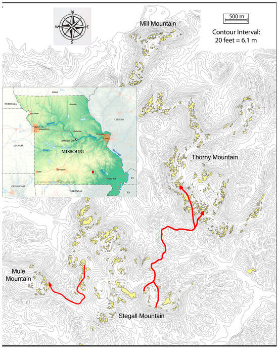
Figure 1.
A topographical map of the mountains colonized by collared lizards. The red rectangle in the inset map of the State of Missouri on the left side indicates the location of the detailed area in the remainder of the figure. The lizards were translocated onto Stegall Mountain and remained there until colonization of the other mountains on this map occurred after prescribed burning of the forested areas between the mountains. Red arrows indicate the paths of least resistance between lizards captured as hatchlings on Stegall Mountain to their recapture points as yearlings on Mule and Thorny Mountains.
Experimental design options are highly restricted when implementing a long-term conservation management program in a large and rugged landscape. This is particularly true for this study which involved prescribed burns over a rugged landscape, with individual burn units being as large as 5 hectares. Such burns require a well-trained and large burn crew working many days in preparing the periphery of the planned burn as well as setting and monitoring the fire constantly until it is completely out. Given these severe logistic constraints, the optimal design was temporal control coupled with replication. Surveys were conducted in an area designated for a new management policy before that policy was implemented to assess the pre-policy state. Surveys were then continued after the implementation of the new management policy to monitor its impact through a temporal before-and-after contrast. The temporal contrast is then replicated in at least one other nearby area to monitor concordance of the results.
For example, the first translocation populations of collared lizards occurred in 1984 on Stegall Mountain. For ten years not a single dispersal event was observed, despite two of the translocation glades being only 50 m apart. Moreover, no new glades were colonized despite the existence of many nearby restored glades. In February of 1994, prescribed burning of both glades and the forests in which the glades were imbedded was added to the management of Stegall Mountain. Both dispersal and colonization of new glades was observed on Stegall Mountain in an explosive fashion [5]. Moreover, this result was replicated in another part of the Peck Ranch Conservation area. In 1987 five females and four males were translocated to Stalcup Hollow Glade, located some 7.6 km SE of the Stegall lookout tower. This was in a completely different geological part of the Peck Ranch consisting of dolomitic ridges separated by narrow valleys (hollows, in the Ozark dialect). This area was separated from the igneous area shown in Figure 1 by a thick forest that remains incompletely burned. The nearest glade (also dolomitic) to Stalcup Hollow was Slick Rock Glade, 530 m to the east. The translocated population on Stalcup Hollow Glade became well established and has persisted. As with Stegall, there was initially no prescribed burning of the area separating these two dolomitic glades until 2006. There was no colonization of Slick Rock over 19 years of no woodland burning. However, Slick Rock was colonized by 2009, indicating that lizards were able to traverse the 530 m within three years after the burn. Hence, the importance of prescribed burning in facilitating dispersal and colonization of collared lizards was replicated in two temporal contrasts.
The experimental design of this study is also replicated with temporal contrasts. Surveys for collared lizard presence was initiated before prescribed burns were extended to the areas between Stegall, Mule, Thorny, and Mill mountains. Monitoring of all mountains then continued after these prescribed burns. This allows the use of temporal contrasts to test the hypothesis that prescribed burns create corridors through forested areas without glades to allow dispersal and colonization of new mountains, with replication over three different mountains.
2.2. Field Survey Methods
There are no roads or trails on Mill Mountain (part of the Ozark National Scenic Riverways owned by the National Park Service) and Mule Mountain (a State Forest), and, with the exception of an unpaved ridge road which quickly became impassable after the initial surveys, there were also no roads or trails on Thorny Mountain. Consequently, all surveys were performed on foot. Table 1 summarizes the number of times the glades on each mountain were visited and the size of the survey teams for specific years.

Table 1.
Summary of the number of visits per glade per year and the size of the survey teams on each mountain for various years in this study.
Only one visit per glade was made when no lizards or scat were observed on a mountain and also during the early years on Stegall when only the translocated glades had lizards. Once lizards were found on any glade on a mountain or new glades on Stegall, the survey effort was increased such that each glade was visited a minimum of three times per field season, which typically went from late April to mid-August. However, hatchlings were primarily caught in mid-August through October after the adults had begun brumation [9]. Three visits were chosen because three was the minimum number needed to estimate the glade population size through mark/recapture methods detailed in [5].
When there were no lizards on a mountain, Mill could be surveyed in a single day, and Thorny in three to four days. Mule Mountain had very few glades (Figure A1) and could be surveyed in a few hours. Once lizards became established on the mountains, it took longer to survey all glades. By 2006, the population size of collared lizards on Thorny Mountain had expanded to the point where it was extremely difficult to obtain in three complete surveys during a field season. Although Thorny was visited sporadically after 2006, there were no longer any three-fold intensive surveys. Accordingly, the Thorny results are reported only for the surveys from 1999 until 2006 (Table 1), with brief mentions of observations made later. In 2014, after one visit to Mill, A.R.T. (the only field worker at that time) experienced a health issue that prevented further field work. Accordingly, 2014 is under-sampled relative to previous years (Table 1).
Upon entering a glade, visual scans were conducted to locate collared lizards, as their sit-and-wait predation strategies typically involve perching on a high rock or ledge. Most often, a lizard would be caught by lassoing, as the lizards would allow humans to get within 2–3 m before running under a rock. On the initial capture of a lizard, each animal was assigned a unique identifier by toe clipping combined with sex. Adults were sexed on the basis of a suite of strongly sexually dimorphic characters [11]. Hatchlings, more difficult to sex, were assigned a unique toe clip number regardless of sex. The large toes on the hind legs were never clipped, so there was a total of 18 toes that could be used in unique combinations. Two to four toes were clipped, but no more than one toe per foot (toe clipping had no detectable impact on survivorship (unpublished data). Because of the length of this study and the large number of lizards captured, some toe clip numbers were used again if the original animal with that number had not been seen or captured for a minimum of three years. The high sample coverages and estimated adult survivorships in these studies [10] ensured that the original animal was deceased.
Each glade was inspected for lizards and for distinctive collared lizard scat. All lizards captured on a glade, whether for the first time or on a recapture, were weighed and measured morphologically [12]. Notes were also made on special observations (such as color). The average processing time for a recaptured lizard was under 5 min, and about 10 min for a newly captured lizard. After processing, all lizards were released at their site of capture.
The methods used to estimate dispersal, glade colonization, population size, age, and life-history parameters are given in detail in previous publications on this system [4,5,9,10,12,13].
2.3. Dispersal Events
A dispersal event was counted every time a recapture occurred on a different glade from the glade of the previous capture. Glades were considered distinct if separated by at least some forested habitat. Previous work had demonstrated that gene flow was greatly restricted even among glades separated by only 50 m of woodland [4,6]. The distance of a dispersal event was recorded conservatively as the straight-line distance between the starting point and the end point. This is undoubtedly an underestimate of the actual distance a lizard traveled. For adjacent or nearby glades, this bias should be minor, but for long distances these straight-line distances could seriously underestimate the actual distance traveled.
On Stegall Mountain, straight line dispersal distances were smaller during colonization and increased with time [5]. Sufficient intra-mountain dispersal was observed on Thorny to test the hypothesis that dispersal distances within Thorny vary with time. The observed dispersal events were divided into two time periods: early (2002, the year of the first observed dispersal event within Thorny, to 2003; and late, 2004–2006.) The observed cumulative distributions of straight-line dispersal distances were then calculated for each time period, and the null hypothesis of no difference in the distributions of dispersed distances between the two time periods was tested with a Kolmogorov–Smirnov two-sample test. Exact significance levels were determined by 10,000 random permutations of the data using the software StatXact Version 11.0 from Cytel Inc., Cambridge, MA, USA.
A Circuitscape Version 3.5.8 analysis [13] indicated that steep slopes represent a high resistance barrier to dispersal. These results were used to define the lowest resistant pathway between mountains for hatchlings captured initially on one mountain and then recaptured as yearlings on a different mountain.
3. Results
The surveys revealed that no lizards were on the three mountains prior to landscape-level inter-mountain prescribed burns. After prescribed burns interconnected the mountains, all three previously uninhabited mountains were ultimately colonized by collared lizards. In three cases hatchlings marked in the Stegall source population were observed as yearling colonists on two of three colonized mountains, thereby confirming that dispersal between the mountains had been established. These three-way replicated temporal contrasts support the hypothesis that prescribed burning of forested, glade-free areas between mountains does indeed establish dispersal corridors that allows the colonization of new mountain systems. However, the inter and intra-mountain dynamics and patterns of colonization varied among all three mountains, as will now be described.
3.1. Colonization of Mule Mountain
Four months after prescribed fire included Mule Mountain in 2001, the largest glade on Mule Mountain was colonized by two yearling collared lizards. Three visits were made that year (Table 1), and two individuals were captured on the first visit. Each of these lizards was recaptured on one subsequent visit. No other lizards were seen or caught. The estimated population size that year as 3.14 lizards with an estimated sample coverage of 86% [5]. Therefore, the probability that one or more lizards was missed is 0.14, and the most likely case is just one uncaptured lizard. One of these initial colonizers was a yearling female captured on Stegall Mountain in 2000 as a hatchling. Figure 1 shows the path of least resistance inferred from a Circuitscape analysis [13]. Another unmarked yearling male was also captured on Mule Mountain in 2001. Since Stegall Mountain was much closer than any other source, this yearling male also most likely came from Stegall Mountain. These lizards colonized the largest glade on Mule Mountain (Figure 1). All the other glades on this mountain were small or had much woody intrusion and were never colonized.
3.2. Colonization of Thorny Mountain
Figure 2 shows the colonization history of glades on Thorny Mountain after the 1999 prescribed burn. In 2000 collared lizard scat was observed on two glades, both located in the southern part of Thorny Mountain, indicating that colonization had begun a little over one year after the 1999 burn. By 2001 lizards were captured on four glades, in both the southern and northern parts of Thorny. Thereafter, the number of colonized glades increased steadily (Figure A2), with some extinction and recolonization (Figure 2). Glades in the middle, unburned portion of Thorny tended not to be colonized (Figure 2). The estimated population sizes on Thorny also rapidly increased throughout this study period (Figure A3). Direct dispersal from Stegall to Thorny was observed in two lizards first captured on Stegall as hatchlings and then recaptured as yearlings on Thorny (Figure 1). Lowest resistance pathways suggest both lizards dispersed from glades on Stegall to glades on Thorny via a nearby low ridge interconnecting the two mountains. This ridge had the lowest resistance to dispersal of all possible interconnections between these two mountains (Figure 1).
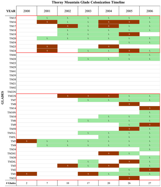
Figure 2.
Glade colonization of Thorny Mountain over time. The glades are roughly ordered north-west to south-east in going from the top to the bottom of this figure. The glades under burn management during the study period are enclosed by red boxes. Glades smaller than the smallest glade colonized are not shown. Brown with the letter S indicates collared lizard scat was found on the glade, and green with the letter L indicates that lizards were found on the glade. The total number of glades with scat or lizards per year is indicated at the bottom in the row labelled “# Glades”.
Once multiple glades had been colonized, the mark/recapture data could also be used to document dispersal between glades on Thorny. These dispersal events are shown in Figure A4. The dispersal distances during the early phase of colonization were larger than those found in the later phase of colonization (Figure 3) as measured by straight lines between the starting glade and the finishing glade. A Kolmogorov–Smirnov two-sample test indicates a highly significant larger dispersal distances for the early phase of colonization with p = 0.0013 (p = 0.0025 for a 2-sided test). It should be noted that straight-line distances are more likely to be accurate indicators of actual dispersal distance when the dispersal is mostly between adjacent glades, as it was in 2004–2006, whereas long straight-line distances are more likely to be underestimates of actual dispersal distances. For example, Figure A4 shows a long dispersal event from the southern part of Thorny to the northern part of Thorny. Collared lizards prefer to disperse along ridges and avoid steep slopes [4,5,13]. The ridge distance along sinuous Thorny Mountain is about twice as long as the straight-line distance. This bias makes the significant difference in distances shown in Figure 3 conservative.
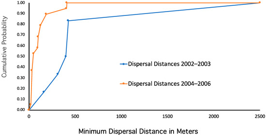
Figure 3.
The cumulative frequency distributions of the minimum dispersal distance (straight-line dispersal) observed during the colonization of Thorny Mountain during the early phase of colonization (2002–2003) and the later phase of colonization (2004–2006).
3.3. Colonization of Mill Mountain
The area between Mill and Thorny Mountains was burned in the spring of 2000. The steep valley between these two mountains is narrow, with the valley bottom being only about 20 m wide (Figure A5). Moreover, unlike the undeveloped valley between Stegall and Thorny, a two-lane paved road runs through this valley, completely separating Mill from Thorny. During the summer months, this road has a fair amount of traffic because it leads to an access point on the Current River, part of the Ozark National Scenic Riverways of the National Park Service.
Unlike the colonization of Mule and Thorny Mountains, no lizard captured on Mill had previously been marked on another mountain. However, geographical proximity suggests that northern Thorny is the likely source of Mill colonists (Figure A5). Figure 4 shows the colonization sequence of glades on Mill Mountain. The number of glades colonized over time is shown in Figure A2, and the estimated population size over time are shown in Figure A3. All observed inter-glade dispersal events occurred between 2012 and 2014 inclusively, and are shown graphically in Figure A5.
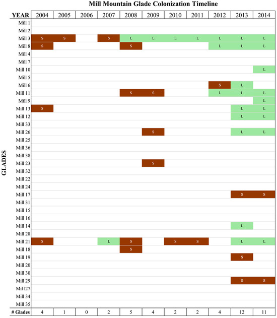
Figure 4.
Glade colonization of Mill Mountain over time. The glades are roughly ordered from south-west to north-east in going from the top to the bottom of this figure. Brown with the letter S indicates collared lizard scat was found on the glade, and green with the letter L indicates that lizards were found on the glade. The total number of glades with scat or lizards per year is indicated at the bottom in the row labelled “# Glades”. Only one visit was made in 2014, so that this year is under-sampled relative to the other years.
4. Discussion
4.1. Inter-Mountain Dispersal Dynamics
The successful colonization of three mountains after prescribed burning indicates that such burns are an effective tool for establishing dispersal corridors for collared lizards across areas with no glades. Many other species live in fire-maintained communities [14]. Hence, prescribed burns may be an important conservation management tool for establishing dispersal corridors for other species.
There have been many studies on the impact of fire on dispersal, mostly in plants, but some in animals [15,16]. Most of the animal studies reviewed in these papers [15,16] were primarily concerned with the impact on dispersal of burn history or movement through a large fire maintained community, such as a savanna, as well as movements triggered directly by fire. Reviewed studies that focused on movement between habitat patches, such as the glades in this paper, were more limited. Moreover, the habitat patch studies were in the context of dispersal “motivated by the need to leave a site that has become unsuitable” [15] (p. 984). Motivation due to habitat quality is unlikely to be the driving force in the study presented here, as the continued occupation and high population numbers in the source glades on Stegall Mountain (Figure A2 and Figure A3) suggests that the continued fire management regime has maintained these glades as highly suitable habitats for collared lizards. What, then, could motivate lizards from Stegall to disperse through kilometers of burned space with no glades?
First, consider the ability of collared lizards to make such a long dispersal event. The burned forests show a 410% increase in the abundance of orthopterans over an unburned forest [10]. Since orthopterans are the primary prey for collared lizards [17], so food is much more abundant in a recently burned forest than in an unburned forest. Also, there are many light patches on the burned forest floor that would be important for thermoregulation [10]. Prey abundance and light patches can explain the ability of lizards to make long dispersal events through a gladeless, burned forest, but not the motivation.
Instead, the social behavior of these lizards provides a possible motivation for these long dispersal events through burned woodland. Specifically, in this system, all observed dispersal events to new mountain systems involved hatchlings. Both male and female adult collared lizards are territorial, and defend these territories aggressively against other lizards [13]. Moreover, adult collared lizards are cannibalistic towards hatchlings [18]. Hence, in a glade occupied by many adults, a hatchling or a yearling would have little chance of establishing a territory and moreover would be at risk of being eaten. Indeed, hatchlings spend their time at the margins of the glades and in the forest edges during the summer and only move into the central portions of the glades after the adults have begun brumation in late August and early September (personal observations). These observations imply that social and predator-prey interactions with adult lizards could be a motivating factor for long distance dispersal events through gladeless areas.
4.2. Inter-Mountain Colonization Patterns
Although all three mountain colonizations are concordant with the main hypothesis that prescribed fires between mountains can create dispersal corridors, each mountain had a different pattern of colonization, and these differences reveal additional features about dispersal and colonization, as will now be discussed.
Mule Mountain was quickly colonized within four months of the burn. Conley, Neuwald and Templeton [13] used a landscape analysis that revealed that steep slopes have a high resistance to dispersal. In contrast, relatively flat ridges have the least resistance to dispersal. As shown in Figure 1, although Mule is separated from Stegall by about one km, it is connected by a high ridge with no steep slopes. Hence, this 1 km ridge with no glades does not serve as a barrier to colonization and dispersal once the ecosystem has been fire-restored. Indeed, the first lizard to disperse from Stegall to Mule came from a glade close to this low resistance ridge (Figure 1). Subsequently, dispersal reached the levels indicative of a single stable metapopulation, and the single colonized glade on Mule Mountain was included as part of Stegall Mountain in previous analysis [4,5,8,9,10,13]. In this case, the dispersal corridor between Stegall and Mule allowed the absorption of the Mule population into the Stegall metapopulation (Figure A2 and Figure A3).
Thorny Mountain was colonized by the Stegall Mountain population within a little more than a year after the burn. Direct dispersal between Stegall to Thorny was observed (Figure 1). Figure 1 shows a ridge interconnecting Stegall and Thorny mountains. At all other places, the valley between the two mountains is much broader and there are two creeks that start at this ridge, one going to the southeast and the other to the northwest (Figure 1). The ridge in Figure 1 is the only connection between the two mountains that does not require crossing a creek. After the prescribed 1999 burn, A.R.T. walked this ridge and observed that the woody understory had been largely cleared. Moreover, the forest floor was now dominated by grasses and herbaceous plants, with many light patches. These attributes facilitate dispersal of hatchlings through a forested habitat [4,5]. Indeed, two hatchlings marked on glades from this south-eastern knoll of Stegall were captured as yearlings on glades on the south-eastern part of Thorny (Figure 1). The glades on Stegall that produced known dispersers to Thorny were both located near the curving ridge interconnecting the two mountains (Figure 1). Figure 1 also shows the paths of least resistance to dispersal that interconnect the southernmost portions of both mountains. This path has greater resistance than the ridge between Stegall and Mule (Figure 1). Moreover, the minimum straight-line distance between Stegall and Thorny is around 2 km, and following the curves of the red paths shown in Figure 1 are about 3 km. This southern portion of Thorny was also the first site on the mountain with observed scat and lizards, indicating that this was the area of initial colonization. These observations indicate that dispersal from Stegall to Thorny was established shortly after the 1999 prescribed burn and are consistent with the ridge shown in Figure 1 being a dispersal corridor. However, movement between Thorny and Stegall would be more difficult than between Mule and Stegall because of both distance and resistance. This would explain the initial small population size on Thorny (Figure A3) as being due to a founder event because few lizards were able to cross from Stegall to Thorny. A strong founder effect has been confirmed genetically [19]. After this initial colonization, the number of glades colonized and the population size on Thorny increased steadily (Figure 2, Figure A2 and Figure A3).
The colonization of Mill Mountain was quite different from Thorny and Mule. Thorny’s colonization was an event that occurred in 2000, with multiple permanent glade populations established by 2001 (Figure 2). In contrast, Mill’s colonization was an erratic process, characterized by the sporadic and transient appearance of individual lizards starting in 2004. A single but small permanent glade population was established in 2008, and multiple glade populations only by 2012. In 2012, 19 lizards were captured on Mill, more than twice the 9 captured in 2011 and much more than any previous year (Figure A3). The estimated sample coverage in 2012 was very high, so the estimated population size using the Chao et al. estimator [20] was 19.66 (Figure A3). This doubling of population size led to an even larger increase in population size in 2013 (an estimated size of 47.57 lizards, Figure A3) and a tripling of the number of glades occupied (Figure 4 and Figure A2).
The transient nature of lizards on Mill prior to 2008 could be a consequence of a very low probability of dispersal to Mill from source populations on nearby Thorny Mountain. A permanent population requires at least one male and one female on the same glade at the same time. On Mill, the presence of single, transient individuals did not start permanent populations (Figure 4). This sporadic colonization cannot be attributed to distance. The glades on the northern part of Thorny are only 330 m away from the nearest glades on Mill (Figure A5), making this the shortest distance between any pair of these four mountains. Moreover, glade populations had been established on the northern part of Thorny as early as 2001 (Figure 2), so there was a nearby source population for the colonization of Mill three years before the first transient lizard was observed. However, Thorny and Mill are separated by a narrow valley with steep slopes on both sides of this valley (Figure A5). A paved road also separates the two mountains. Hence, high resistance due to steep slopes and perhaps the road may be the primary reason why the colonization of Mill from Thorny was such a long and sporadic process.
If geographic distance was the primary constraint for colonizing a new mountain, the relative ease of colonization would be expected to follow the order: Mill (330 m to the nearest source population) > Mule (1 km) > Thorny (2 km). If, instead, dispersal resistance was the primary constraint for colonization, then the relative ease of colonization would follow the order: Mule > Thorny > Mill. The observed results correspond to resistance rather than distance having the stronger impact on colonization. Therefore, the ease of a mountain to be colonized depended less on physical distance and more on resistance factors, which in turn depended upon the dispersal behavior of the target species as well as terrain factors.
4.3. Intra-Mountain Colonization Patterns
In addition to the initial colonization of each mountain, distinct intra-mountain colonization processes were observed as well. First, as previously described [4,5], the colonization phase for new Stegall glades was initiated after prescribed burn management on Stegall Mountain. The source for this colonization was the translocated populations on the same mountain. The colonization of new glades spread out from these source populations is a steady, step-wise fashion that included Mule Mountain once it was incorporated into prescribed burning (see Appendix B in [5]). This colonization phase was characterized by low dispersal rates and small dispersal distances, particularly among hatchlings—the main colonizers [5]. Dispersal rates and distances increased as the population approached saturation and entered a phase of a stable metapopulation on the glades of Stegall/Mule Mountains [5].
The colonization of Thorny Mountain showed an opposite pattern of intra-mountain dispersal from Stegall. On Thorny, there were large dispersal distances during the early phase of colonization followed by a significant shortening of those distances as many glades became inhabited (Figure 3 and Figure A4). One hypothesis for this difference is that dispersing lizards assess the quality of new glades that they encounter, and if the new glade is assessed to be of low quality, the lizard continues its dispersal journey. One important aspect of glade quality might be the presence of lizards of the opposite sex on the glade. A glade with no potential mates obviously would preclude any reproductive success of a newly arrived, dispersing lizard. Stegall had a stable and large source population close to many unoccupied glades when prescribed burning was initiated. As a result, after burning there could be a steady stream of many dispersing individuals that would quickly encounter nearby glades. Under these conditions, the probability that a formerly unoccupied glade would contain at least a male and a female is high, so there would be no incentive for further dispersal. This would yield the observed pattern on Stegall of an initial reduced rate of dispersal, dispersal distances being short, and a steadily increasing geographical front of newly colonized glades from the original source. However, as the population grew, the territoriality of these lizards would reverse these patterns because lizards unable to establish a territory would be motivated to disperse. Indeed, Conley, Neuwald and Templeton [13] showed that lizards had a higher probability of dispersing from a glade that had structural features that facilitated the ability of lizards to completely dominate their territories. Hence, dispersal is expected to increase again in the stable metapopulation phase of Stegall under this hypothesis, as was observed.
In contrast, for Thorny the source population is far away (on a different mountain, Figure 1), and the initial population sizes (Figure A3) and the genetic signature of a founder effect [19] revealed that only a few individuals successfully found their way from Stegall to Thorny. During the 8 years of this study on Thorny (1999 through 2006), a total of 198 hatchlings were marked on Stegall and later recaptured as yearlings or older. Of these, two had dispersed to Thorny (Figure 1) and the remainder were recaptured on Stegall. This yields an annual dispersal rate of 0.0012. As a consequence, the few lizards that initially dispersed to Thorny would be expected to encounter glades that were unlikely to have other lizards, thus motivating further dispersal. Hence, dispersal distances would be large during the years immediately following the initial colonization as more glades are colonized, there are also more lizards and more geographical sources scattered over the mountain to serve as a source for dispersers (Figure 2, Figure A2 and Figure A3). This situation would cause dispersal distances to decrease over time, as observed (Figure 3 and Figure A4).
Another aspect of the colonization of Thorny is revealed in Figure 2. The glades in that figure are ordered from the northwest tip of Thorny to the southeast tip. Note that there are many intervening glades that are not occupied. Many of these glades are very small and scattered geographically over the mountain and were never occupied or only exhibited sporadic presence of scat. These glades are not shown in Figure 2 but can be seen in Figure A4. This parallels the observations on Stegall and Mule: lizards prefer larger glades. However, there are two tight geographical clusters of unoccupied glades or those with sporadic scat, including some large glades. The first cluster of interest is glades TM52, TM12, TM36, TM13U&M, TM13L, TM14, and TM8 that are encircled by a dotted line in Figure A4. All of these glades are centrally located, and glade TM13U&M is one of the larger glades on Thorny (Figure A4). Nevertheless, the only sign of lizards on this central cluster was scat on TM36 in 2005. This glade cluster is on a northeast facing slope (Figure A4), resulting in reduced solar incidence compared to the other glades on Thorny. Collared lizards prefer hot, sunny environments [21], so this failure to colonize even large, centrally located glades indicates that collared lizards select for glades that are hot and sunny during the summer.
The second block with many uncolonized glades is defined by glades TM28 through TM22N in Figure 2 and Figure A4. As mentioned earlier, there was a gap in fire management on Thorny until 2007. This fire management gap covers the glades from TM28 to TM22N. The only glades in this fire management gap that were colonized or had scat were glades that bordered the fire line (Figure 2). There is no doubt that lizards could reach these glades because dispersal events that crossed through this unburned area were detected (Figure A4), allowing the lizards to colonize glades both north and south of the unburned area. Accordingly, their absence in the unburned area indicates that the lizards are actively avoiding colonizing this specific cluster of unburned glades. Further support for this inference comes from a limited survey through much of Thorny in 2008 using the old mining road/jeep trail. This trail passes through the previously unburned area, which had recently been burned in 2007. Lizards were observed and captured in glade TM21, the largest glade in the previously unburned area. Therefore, once burned, this glade was rapidly colonized. This evidence, combined with the results presented above as well as the results given in Conley, Neuwald and Templeton [13] on the structural features of a glade, all indicate that collared lizards are capable of making assessments of glade quality on many dimensions that influence their decisions to remain in or disperse from a glade. Hence, colonization of a new mountain and the glades therein is highly non-random.
Unfortunately, not much can be concluded about dispersal on Mill Mountain, since it was not until 2012 that the colonization of more than one glade began (Figure 4), and sampling was halted in 2014 with an incomplete survey. As a result, very few dispersal events were observed, and all were short distances (Figure 4), which is not unexpected on this small mountain.
4.4. Conclusions
Prescribed burning in the forested grade-free areas between the mountains did establish dispersal corridors that lead to multiple colonizations of new mountains. The lizards colonized these new mountains without human aided translocations. This is an important conclusion for management, because translocations are expensive and time-consuming and typically involve only one species. In contrast, prescribed burning has many conservation benefits for multiple species [14], making it easier to fund and execute. This work also shows that the resistance to dispersal of the terrain separating mountains was a major factor in colonization. Hence, when dispersal corridors are being designed for a specific species, landscape resistance should be considered. The program Circuitscape was used to determine dispersal resistance factors for the collared lizards based on microsatellite genetic variation [13]. Given the advances in genomic technology since these microsatellite surveys were performed, high resolution genetic surveys can now be performed on non-model species. This allows dispersal resistance to be determined through programs like Circuitscape for virtually any species of conservation interest. This work shows the importance of having such resistance data.
This study also shows that the subsequent colonization of the glades on a mountain occurred in a highly non-random fashion. Multiple factors influence this non-random pattern, including burning, internal glade structure, the initial colonization size, ease of recruits from the source mountain, and the plastic social behavior of these territorial lizards. Patently, the more that is known about the basic biology of a species of conservation concern, the better a conservation management program can be designed. In the frequent case in which gaps of knowledge exist for a species of concern, the management program should be designed as an experiment with long-term monitoring to gain that knowledge, as the work on collared lizards illustrates.
None of this colonizing potential could have been realized without landscape level burns that include the intervening terrain that separates the mountains. Hence, dispersal corridors do not require the presence of habitats (in this case, glades) which can sustain a permanent population, but they must be designed and managed in a manner that allows dispersal through them. A lack of fires produces an environment through which collared lizards will not disperse. But if you burn it, they will come.
Author Contributions
A.R.T. secured funding for this project, performed the data analyses, was extensively involved in the field work, and wrote the initial draft of the manuscript. J.L.N. was extensively involved in the field work and contributed extensively and critically to the writing of subsequent drafts of the manuscript. All authors have read and agreed to the published version of the manuscript.
Funding
This work was supported by the National Science Foundation (NSF) grant DEB-9610219 and four REU supplements to this NSF grant to A.R.T. A Canon National Parks Science Scholars Fellowship helped support J.L.N. We also greatly appreciate cooperation and logistical support from the Missouri Department of Conservation, the Department of Natural Resources of the State of Missouri, the National Parks Service, and The Nature Conservancy of Missouri. These organizations provided the funding and personnel for the prescribed burns.
Data Availability Statement
An Excel file giving all the individual mark/recapture data used in this paper is available as Dryad file doi:10.5061/dryad.63xsj3v50. Supplementary Dryad files are also included at this site: a PDF file showing the glades with numbers on Stegall and Mule Mountains overlayed upon a topographic map, PDF file showing the glades with numbers on Thorny Mountain overlayed upon a topographic map, a PDF file showing the glades with numbers on Mill Mountain overlayed upon a topographic map, and a file that gives the latitude and longitude of the glades in this study as determined by GPS. The following information can be downloaded at https://esapubs.org/archive/default.htm, a PowerPoint animation of the rapid colonization of glades on Stegall and Thorny Mountains is available at Ecological Archives E092-148-A2, accessed date 1 September 2011.
Acknowledgments
We would like to thank two anonymous reviewers for their many excellent suggestions that greatly improved this paper. We also thank the many people who helped in capturing collared lizards for this work, including Hilary Brazeal, R. James Robertson, Delbert Hutchison and family, Eric Routman, Christopher Phillips, L. Susan Pletscher, Ted Townsend, Jon Hess, Jennifer Brisson, Jared Strasburg, Rosie Koch, Rebecca Reichert, Aaron Hames, Erin Marnocha, Margaret Lutz, Jeffrey Templeton, Bonnie Templeton, Kenneth Weiner, Greg Stimpson, Ayse Koca, Sana Khan, and Lawrence Wiseman.
Conflicts of Interest
The authors declare no conflicts of interest.
Appendix A

Figure A1.
Prescribed burns at the Peck Ranch Conservation Area and nearby areas between 1994 and 1999. The first prescribed burn, shown by the dashed orange line, included the northern half of Stegall Mountain. Subsequent burns expanded this area. In 1997, the southern half of Thorny Mountain was burned and all of Mill Mountain. In 1999 a large prescribed burn included all of Stegall Mountain, the southern half of Thorny Mountain, and the valley area in between Stegall and Thorny. An unburned middle section until 2007 is indicated between the 1999 burn line and the red line. The glades of the three translocated lizard populations are in indicated by red dots.

Figure A2.
The time course of the number of glades colonized on Stegall (black), Thorny (red) and Mill (blue) Mountains. The major demographic phases are shown by bars. The timing of major events in burn management are indicated by text and arrows pointing to the time line. Only a single glade on Mule Mountain was colonized in 2001, and that glade is included in the numbers of colonized glades on Stegall thereafter. * Sampling in 2014 was incomplete.

Figure A3.
The time course of the estimated population sizes on Stegall, Thorny and Mill Mountains. The major demographic phases are shown by bars. The timing of major events in burn management are indicated by text and arrows pointing to the time line. Only a single glade on Mule Mountain was colonized in 2001, and that glade population is included in the numbers of lizards on Stegall thereafter.

Figure A4.
The inter-glade dispersal events that occurred on Thorny mountain between 2001 and 2006. The events up to and including year 2003 are shown as red arrows, whereas the events occurring from 2004 until 2006 are shown as dashed blue arrows. The dashed black line encircles a cluster of glades that were north to northeast facing. The dashed red line encircles an area of private land not included in the prescribed burning plan until 2007. All glades were assigned a number, and in some cases letters indicate a subsection of the glade.

Figure A5.
Topographic map showing the northwestern portion of Thorny Mountain and Mill Mountain. The inter-glade dispersal events that occurred on Mill Mountain in 2013 and 2014 are shown by red arrows.
References
- Guyette, R.; McGinnes, E.A., Jr. Fire history of an Ozark glade in Missouri. Trans. Missouri Acad. Sci. 1987, 16, 85–93. [Google Scholar]
- Denter, H. Shooting the Smoke: Fire Towers in Missouri. Mo. Conserv. 2022, 83, 22–27. [Google Scholar]
- Templeton, A.R. Translocation in conservation. In Biodiversity in Managed Landscapes: Theory and Practice; Szaro, R.C., Johnston, D.W., Eds.; Oxford University Press: Oxford, UK, 1996; pp. 315–325. [Google Scholar]
- Neuwald, J.L.; Templeton, A.R. Genetic restoration in the eastern collared lizard under prescribed woodland burning. Mol. Ecol. 2013, 22, 3666–3679. [Google Scholar] [CrossRef]
- Templeton, A.R.; Brazeal, H.; Neuwald, J.L. The transition from isolated patches to a metapopulation in the eastern collared lizard in response to prescribed fires. Ecology 2011, 92, 1736–1747. [Google Scholar] [CrossRef]
- Templeton, A.R.; Robertson, R.J.; Brisson, J.; Strasburg, J. Disrupting evolutionary processes: The effect of habitat fragmentation on collared lizards in the Missouri Ozarks. Proc. Natl. Acad. Sci. USA 2001, 98, 5426–5432. [Google Scholar] [CrossRef] [PubMed]
- Nigh, T.A.; Pflieger, W.L.; Redfearn, J.P.L.; Schroeder, W.A.; Templeton, A.R.; Thompson, F.R., III. The Biodiversity of Missouri; Missouri Department of Conservation: Jefferson City, MO, USA, 1992; p. 53.
- Templeton, A.R.; Neuwald, J.L.; Brazeal, H.; Robertson, R.J. Restoring demographic processes in translocated populations: The case of collared lizards in the Missouri Ozarks using prescribed forest fires. Isr. J. Ecol. Evol. 2007, 53, 179–196. [Google Scholar] [CrossRef]
- Templeton, A.R.; Neuwald, J.L.; Conley, A.K. Age structure dynamics in an eastern collared lizard population from founding to demographic stability. Anim. Conserv. 2023, 26, 165–173. [Google Scholar] [CrossRef]
- Templeton, A.R.; Neuwald, J.L.; Conley, A.K. Life history changes in the eastern collared lizard in response to varying demographic phases and management policies. Popul. Ecol. 2024, 66, 53–67. [Google Scholar] [CrossRef]
- McGuire, J.A. Phylogenetic Systematics of Crotaphytid Lizards (Reptilia: Iguania: Crotaphytidae); Carnegie Institute: Pittsburgh, PA, USA, 1996. [Google Scholar]
- Brisson, J.A.; Strasburg, J.L.; Templeton, A.R. Impact of fire management on the ecology of collared lizard (Crotaphytus collaris) populations living on the Ozark Plateau. Anim. Conserv. 2003, 6, 247–254. [Google Scholar] [CrossRef]
- Conley, A.K.; Neuwald, J.L.; Templeton, A.R. Network analyses of the impact of visual habitat structure on behavior, demography, genetic diversity, and gene flow in a metapopulation of collared lizards (Crotophytus collaris collaris). In New Horizons in Evolution; Wasser, S.P., Frenkel-Morgenstern, M., Eds.; Academic Press: Oxford, UK, 2021; pp. 131–160. [Google Scholar]
- Pyne, S.J. The Pyrocene; University of California Press: Oakland, CA, USA, 2021; p. 255. [Google Scholar]
- Nimmo, D.G.; Avitabile, S.; Banks, S.C.; Bird, R.B.; Callister, K.; Clarke, M.F.; Dickman, C.R.; Doherty, T.S.; Driscoll, D.A.; Greenville, A.C.; et al. Animal movements in fire-prone landscapes. Biol. Rev. 2019, 94, 981–998. [Google Scholar] [CrossRef] [PubMed]
- Harris, J.; Chapple, D.G.; McLean, C.A.; Melville, J. Genetic footprints of fire: Understanding the genetic implications of fire regimes for fauna and effective conservation strategies. Biol. Conserv. 2023, 284, 110169. [Google Scholar] [CrossRef]
- McAllister, C.T. Food-habits and feeding-behavior of Crotaphytus collaris collaris (Iguanidae) from Arkansas and Missouri. Southwest. Nat. 1985, 30, 597–600. [Google Scholar] [CrossRef]
- Polis, G.A.; Myers, C.A. A survey of intraspecific predation among reptiles and amphibians. J. Herpetol. 1985, 19, 99–107. [Google Scholar] [CrossRef]
- Templeton, A.R. Lessons Learned in the Field About Habitat Fragmentation. Isr. J. Ecol. Evol. 2025, in press.
- Chao, A.; Lee, S.M.; Jeng, S.L. Estimating population-size for capture recapture data when capture probabilities vary by time and individual animal. Biometrics 1992, 48, 201–216. [Google Scholar] [CrossRef] [PubMed]
- Angert, A.L.; Hutchison, D.; Glossip, D.; Losos, J.B. Microhabitat use and thermal biology of the Collared Lizard (Crotaphytus collaris collaris) and the Fence Lizard (Sceloporus undulatus hyacinthinus) in Missouri glades. J. Herpetol. 2002, 36, 23–29. [Google Scholar] [CrossRef]
Disclaimer/Publisher’s Note: The statements, opinions and data contained in all publications are solely those of the individual author(s) and contributor(s) and not of MDPI and/or the editor(s). MDPI and/or the editor(s) disclaim responsibility for any injury to people or property resulting from any ideas, methods, instructions or products referred to in the content. |
© 2025 by the authors. Licensee MDPI, Basel, Switzerland. This article is an open access article distributed under the terms and conditions of the Creative Commons Attribution (CC BY) license (https://creativecommons.org/licenses/by/4.0/).