Prediction of Urban Growth and Sustainability Challenges Based on LULC Change: Case Study of Two Himalayan Metropolitan Cities
Abstract
1. Introduction
- (1)
- How did LULC change occur in the past (1988–2024), and which classes and locations were the most impacted by urbanization?
- (2)
- What patterns of growth and change are projected for the years 2040 and 2056 using Cellular Automata Markov chain (CA-Markov chain)?
2. Materials and Methods
2.1. Study Area
2.2. Data
2.3. Image Pre-Processing and Classification
2.4. Accuracy Assessment
2.5. Cellular Automated (CA) Markov Chain and Simulation of LULC Change
| 0 | 0 | 1 | 0 | 0 |
| 0 | 1 | 1 | 1 | 0 |
| 1 | 1 | 1 | 1 | 1 |
| 0 | 1 | 1 | 1 | 0 |
| 0 | 0 | 1 | 0 | 0 |
2.6. Validation
3. Results and Analysis
3.1. LULC Change Analysis for Kathmandu Valley
3.2. LULC Change Analysis for Pokhara Metropolitan City
3.3. CA-Markov Model
3.3.1. LULC Prediction for Kathmandu Valley for 2040 and 2056
3.3.2. LULC Prediction for Pokhara for 2040 and 2056
4. Discussion and Conclusions
Author Contributions
Funding
Data Availability Statement
Acknowledgments
Conflicts of Interest
Appendix A
| Year | 1988 | 1992 | 2000 | 2008 | 2016 | 2024 |
|---|---|---|---|---|---|---|
| Months and Day | 3 April 12 October | 13 March 23 October | 19 March (TM) 22 Novembre | 26 April 20 November | 12 February 10 November | 13 March 23 October |
| Sensor | TM | TM | ETM | TM | OLI | OLI |
| Year | 1988 | 1992 | 2000 | 2008 | 2016 | 2024 |
|---|---|---|---|---|---|---|
| Months and Day | 6 February 19 October | 4 March 15 November | 15 February 10 October (1999) | 29 February 26 October | 22 March 01 November | 29 April 07 November |
| Sensor | TM | TM | ETM | TM | OLI | OLI |
Appendix B. Definition of Weights for Analysis
| Factors | Weight | Control Points |
| Distance from forest | 0.12 | 0–500 m, no suitability 500–5000, increasing suitability 5000 m, highest suitability |
| Slope | 0.16 | 0%, highest suitability 0–15%, decreasing suitability >15%, no suitability |
| Distance from major roads | 0.25 | 0–500 m, highest suitability 500–5000 m, decreasing suitability >5000 m, no suitability |
| Distance from waterbodies | 0.12 | 0–100 m, no suitability 100–7500, increasing suitability >7500 m, highest suitability |
| Distance from built-up areas | 0.35 | 0–100 m, highest suitability 100–5000 m, decreasing suitability >5000 m, no suitability |
Appendix C

References
- Fang, Z.; Ding, T.; Chen, J.; Xue, S.; Zhou, Q.; Wang, Y.; Huang, Z.; Yang, S. Impacts of land use/land cover changes on ecosystem services in ecologically fragile regions. Sci. Total Environ. 2022, 831, 154967. [Google Scholar] [CrossRef] [PubMed]
- Koko, A.F.; Wu, Y.; Abubakar, G.A.; Alabsi, A.A.N.; Hamed, R.; Bello, M. Thirty Years of Land Use/Land Cover Changes and Their Impact on Urban Climate: A Study of Kano Metropolis, Nigeria. Land 2021, 10, 1106. [Google Scholar] [CrossRef]
- Mahtta, R.; Fragkias, M.; Güneralp, B.; Mahendra, A.; Reba, M.; Wentz, E.A.; Seto, K.C. Urban land expansion: The role of population and economic growth for 300+ cities. Npj Urban Sustain. 2022, 2, 5. [Google Scholar] [CrossRef]
- Winkler, K.; Fuchs, R.; Rounsevell, M.; Herold, M. Global land use changes are four times greater than previously estimated. Nat. Commun. 2021, 12, 2501. [Google Scholar] [CrossRef] [PubMed]
- Seto, K.C. Exploring the dynamics of migration to mega-delta cities in Asia and Africa: Contemporary drivers and future scenarios. Glob. Environ. Change 2011, 21, S94–S107. [Google Scholar] [CrossRef]
- Pandey, B.; Seto, K.C. Urbanization and agricultural land loss in India: Comparing satellite estimates with census data. J. Environ. Manage. 2015, 148, 53–66. [Google Scholar] [CrossRef]
- Zhang, X.Q. The trends, promises and challenges of urbanisation in the world. Habitat. Int. 2016, 54, 241–252. [Google Scholar] [CrossRef]
- Elisa, M.; Gabriela, A. Nepal’s Urban Growth and Spatial Transition: An Initial Assessment; The World Bank: Washington, DC, USA, 2013. [Google Scholar]
- NSO. National Population and Housing Census 2021; National Planning Commission Office of the Prime Minister and Council of Ministers; National Statistical Office (NSO): Thapathali, Nepal, 2021.
- Timsina, T.P.; Anushiya, S.; Dilli Prasad, P.; Rachana, U. Trend of Urban Growth in Nepal with a Focus in Kathmandu Valley: A Review of Processes and Drivers of Change; Tomorrow’s Cities publications; The UKRI GCRF Urban Disaster Risk Hub ECCI High School Yards: Edinburgh, UK, 2020. [Google Scholar]
- Rijal, S.; Rimal, B.; Stork, N.; Sharma, H.P. Quantifying the drivers of urban expansion in Nepal. Environ. Monit. Assess. 2020, 192, 633. [Google Scholar] [CrossRef]
- Thapa, R.B.; Murayama, Y. Examining Spatiotemporal Urbanization Patterns in Kathmandu Valley, Nepal: Remote Sensing and Spatial Metrics Approaches. Remote Sens. 2009, 1, 534–556. [Google Scholar] [CrossRef]
- Thapa, R.B.; Murayama, Y. Drivers of urban growth in the Kathmandu valley, Nepal: Examining the efficacy of the analytic hierarchy process. Appl. Geogr. 2010, 30, 70–83. [Google Scholar] [CrossRef]
- Poudel, K.R.; Shrestha, S. Urban Spatial Growth and Geo-Environmental Risk in Pokhara Metropolitan City: A Geospatial Analysis. Nepal J. Environ. Sci. 2025, 13, 15–28. [Google Scholar] [CrossRef]
- Rimal, B.; Zhang, L.; Stork, N.; Sloan, S.; Rijal, S. Urban expansion occurred at the expense of agricultural lands in the Tarai region of Nepal from 1989 to 2016. Sustainability 2018, 10, 1341. [Google Scholar] [CrossRef]
- Bhattarai, K.; Adhikari, A.P.; Gautam, S.P. State of urbanization in Nepal: The official definition and reality. Environ. Chall. 2023, 13, 100776. [Google Scholar] [CrossRef]
- MoUD. National Urban Development Strategy (NUDS), Part A Main Document; Government of Nepal, Ministry of Urban Development Urban Development and Physical Planning Division, Singa Durbar: Kathmandu, Nepal, 2017.
- Poudel, K.R.; Thapa, R.B.; Ghimire, M.; Hamal, R. Urban Growth and Urban Land Use Dynamics of Pokhara City, Nepal: Challenge to Urban Sustainability? In Sustainability in South Asian Cities; Anand, S., Bhattacharyya, R., Das, M., Das, T.K., Pradhan, P.K., Eds.; Springer Nature: Singapore, 2025; pp. 421–439. [Google Scholar] [CrossRef]
- Rimal, B.; Paudel, B.; Rijal, S.; Pangali Sharma, T.P.; Pandey, P. Changing Pattern and Drivers of Land Use and Land Cover in Bagmati Province of Nepal. Himal. Rev. 2024, 45, 1–18. [Google Scholar] [CrossRef]
- KVDA. Vision 2035 and Beyond: 20 Years Strategic Development Master Plan (2015-2035) for Kathmandu Valley; Kathmandu Valley Development Authority (KVDA): Anamngar, Nepal; Nepal Government, Ministry of Urban Development (MoUD), Singa Durbar: Kathmandu, Nepal, 2015.
- MoLRM. National Land Use Policy 2015; Ministry of Land Reform and Management, Government of Nepal: Kathmandu, Nepal, 2015.
- MoLRM. Land Use Act of Nepal 2019; Ministry of Land Reform and Management, Government of Nepal: Kathmandu, Nepal, 2019.
- Nepal, P.; Khanal, N.R.; Zhang, Y.; Paudel, B.; Liu, L. Land use policies in Nepal: An overview. Land Degrad. Dev. 2020, 31, 2203–2212. [Google Scholar] [CrossRef]
- Subasinghe, S.; Estoque, R.C.; Murayama, Y. Spatiotemporal analysis of urban growth using GIS and remote sensing: A case study of the Colombo metropolitan area, Sri Lanka. ISPRS Int. J. Geo-Inf. 2016, 5, 197. [Google Scholar] [CrossRef]
- Rashid, K.J.; Akter, T.; Imrul Kayes, A.S.M.; Yachin Islam, M. Exploring the Spatio-temporal Patterns and Driving Forces of Urban Growth in Dhaka Megacity from 1990 to 2020. In Urban Commons, Future Smart Cities and Sustainability; Chatterjee, U., Bandyopadhyay, N., Setiawati, M.D., Sarkar, S., Eds.; Springer International Publishing: Cham, Switzerland, 2023; pp. 375–400. [Google Scholar] [CrossRef]
- Sarwar, S.; Khan, H.U.A.; Wu, F.; Hasan, S.; Zohaib, M.; Abbasi, M.; Hu, T. Forecasting Urban Sprawl Dynamics in Islamabad: A Neural Network Approach. Remote Sens. 2025, 17, 492. [Google Scholar] [CrossRef]
- Jedwab, R.; Loungani, P.; Yezer, A. Comparing cities in developed and developing countries: Population, land area, building height and crowding. Reg. Sci. Urban Econ. 2021, 86, 103609. [Google Scholar] [CrossRef]
- Sarif, M.O.; Rimal, B.; Stork, N.E. Assessment of changes in land use/land cover and land surface temperatures and their impact on surface Urban heat Island phenomena in the Kathmandu Valley (1988–2018). ISPRS Int. J. Geo-Inf. 2020, 9, 726. [Google Scholar] [CrossRef]
- Singh, B.; Venkatramanan, V.; Deshmukh, B. Monitoring of land use land cover dynamics and prediction of urban growth using Land Change Modeler in Delhi and its environs, India. Environ. Sci. Pollut. Res. 2022, 29, 71534–71554. [Google Scholar] [CrossRef] [PubMed]
- Hekmat, H.; Ahmad, T.; Singh, S.K.; Kanga, S.; Meraj, G.; Kumar, P. Land Use and Land Cover Changes in Kabul, Afghanistan Focusing on the Drivers Impacting Urban Dynamics during Five Decades 1973–2020. Geomatics 2023, 3, 447–464. [Google Scholar] [CrossRef]
- Wang, S.W.; Munkhnasan, L.; Lee, W.K. Land use and land cover change detection and prediction in Bhutan’s high altitude city of Thimphu, using cellular automata and Markov chain. Environ. Chall. 2021, 2, 100017. [Google Scholar] [CrossRef]
- Tariq, A.; Mumtaz, F. Modeling spatio-temporal assessment of land use land cover of Lahore and its impact on land surface temperature using multi-spectral remote sensing data. Environ. Sci. Pollut. Res. 2023, 30, 23908–23924. [Google Scholar] [CrossRef]
- Shi, Y.; Bilal, M.; Ho, H.C.; Omar, A. Urbanization and regional air pollution across South Asian developing countries—A nationwide land use regression for ambient PM2.5 assessment in Pakistan. Environ. Pollut. 2020, 266, 115145. [Google Scholar] [CrossRef]
- Hussain, S.; Mubeen, M.; Nasim, W.; Mumtaz, F.; Abdo, H.G.; Mostafazadeh, R.; Fahad, S. Assessment of future prediction of urban growth and climate change in district Multan, Pakistan using CA-Markov method. Urban Clim. 2024, 53, 101766. [Google Scholar] [CrossRef]
- Cortinovis, C.; Geneletti, D.; Haase, D. Higher immigration and lower land take rates are driving a new densification wave in European cities. Npj Urban Sustain. 2022, 2, 19. [Google Scholar] [CrossRef]
- Chakraborty, S.; Maity, I.; Dadashpoor, H.; Novotnẏ, J.; Banerji, S. Building in or out? Examining urban expansion patterns and land use efficiency across the global sample of 466 cities with million+ inhabitants. Habitat. Int. 2022, 120, 102503. [Google Scholar] [CrossRef]
- Poudel, N.; Shaw, R. Challenges of Urban Water Security and Drivers of Water Scarcity in Kathmandu Valley, Nepal. Urban Sci. 2025, 9, 54. [Google Scholar] [CrossRef]
- Farhan, M.; Wu, T.; Anwar, S.; Yang, J.; Naqvi, S.A.A.; Soufan, W.; Tariq, A. Predicting Land Use Land Cover Dynamics and Land Surface Temperature Changes Using CA-Markov-Chain Models in Islamabad, Pakistan (1992-2042). IEEE J Sel Top Appl Earth Obs. Remote Sens 2024, 7, 16255–16271. [Google Scholar] [CrossRef]
- Farhan, M.; Wu, T.; Amin, M.; Tariq, A.; Guluzade, R.; Alzahrani, H. Monitoring and prediction of the LULC change dynamics using time series remote sensing data with Google Earth Engine. Phys. Chem. Earth Parts A/B/C 2024, 136, 103689. [Google Scholar] [CrossRef]
- Küçük Matci, D.; Comert, R.; Avdan, U. Analyzing and Predicting Spatiotemporal Urban Sprawl in Eskişehir Using Remote Sensing Data. J. Indian Soc. Remote Sens. 2022, 50, 923–936. [Google Scholar] [CrossRef]
- Eastman, J.R.; Van Fossen, M.E.; Solarzano, L.A. Transition potential modeling for land cover change. GIS Spat. Anal. Model. 2005, 17, 357–386. [Google Scholar]
- Aburas, M.M.; Ho, Y.M.; Pradhan, B.; Salleh, A.H.; Alazaiza, M.Y.D. Spatio-temporal simulation of future urban growth trends using an integrated CA-Markov model. Arab. J. Geosci. 2021, 14, 131. [Google Scholar] [CrossRef]
- Keshtkar, H.; Voigt, W. Potential impacts of climate and landscape fragmentation changes on plant distributions: Coupling multi-temporal satellite imagery with GIS-based cellular automata model. Ecol. Inform. 2016, 32, 145–155. [Google Scholar] [CrossRef]
- Wu, D.; Liu, J.; Wang, S.; Wang, R. Simulating urban expansion by coupling a stochastic cellular automata model and socioeconomic indicators. Stoch. Environ. Res. Risk Assess. 2010, 24, 235–245. [Google Scholar] [CrossRef]
- Moghadam, H.S.; Helbich, M. Spatiotemporal urbanization processes in the megacity of Mumbai, India: A Markov chains-cellular automata urban growth model. Appl. Geogr. 2013, 40, 140–149. [Google Scholar] [CrossRef]
- Estoque, R.C.; Ooba, M.; Togawa, T.; Hijioka, Y.; Murayama, Y. Monitoring global land-use efficiency in the context of the UN 2030 Agenda for Sustainable Development. Habitat Int. 2021, 115, 102403. [Google Scholar] [CrossRef]
- Hu, G.; Li, X.; Liu, X.; Wang, S.; Zhang, X.; Shi, X.; Bai, X.; Hubacek, K. Mitigating the ripple effects of urbanization on farmland productivity and ecological security through inclusive urbanization strategies. Npj Urban Sustain. 2025, 5, 12. [Google Scholar] [CrossRef]
- Tahir, Z.; Haseeb, M.; Mahmood, S.A.; Batool, S.; Abdullah-Al-Wadud, M.; Ullah, S.; Tariq, A. Predicting land use and land cover changes for sustainable land management using CA-Markov modelling and GIS techniques. Sci. Rep. 2025, 15, 3271. [Google Scholar] [CrossRef] [PubMed]
- Tapia, C.; Randall, L.; Wang, S.; Aguiar Borges, L. Monitoring the contribution of urban agriculture to urban sustainability: An indicator-based framework. Sustain. Cities Soc. 2021, 74, 103130. [Google Scholar] [CrossRef]
- Tiwary, A.; Brown, N. Emerging Perspectives on Diverse Nature-Oriented Sustainability Strategies. Sustainability 2024, 16, 881. [Google Scholar] [CrossRef]
- Haack, B.N.; Rafter, A. Urban growth analysis and modeling in the Kathmandu Valley, Nepal. Habitat. Int. 2006, 30, 1056–1065. [Google Scholar] [CrossRef]
- Ishtiaque, A.; Shrestha, M.; Chhetri, N. Rapid urban growth in the Kathmandu Valley, Nepal: Monitoring land use land cover dynamics of a himalayan city with landsat imageries. Environments 2017, 4, 72. [Google Scholar] [CrossRef]
- Thapa, R.B.; Murayama, Y. Scenario based urban growth allocation in Kathmandu Valley, Nepal. Landsc. Urban Plan. 2012, 105, 140–148. [Google Scholar] [CrossRef]
- Haack, B. A History and Analysis of Mapping Urban Expansion in the Kathmandu Valley, Nepal. Cartogr. J. 2009, 46, 233–241. [Google Scholar] [CrossRef]
- Fort, M. The Pokhara Valley: A Product of a Natural Catastrophe. In Geomorphological Landscapes of the World, Dordrecht; Migon, P., Ed.; Springer: Dordrecht, The Netherlands, 2010; pp. 265–274. [Google Scholar] [CrossRef]
- Paudel, B.; Zhang, Y.; Yan, J.; Rai, R.; Li, L. Farmers’ perceptions of agricultural land use changes in Nepal and their major drivers. J. Environ. Manage. 2019, 235, 432–441. [Google Scholar] [CrossRef]
- Rai, R.; Zhang, Y.; Paudel, B.; Acharya, B.K.; Basnet, L. Land use and land cover dynamics and assessing the ecosystem service values in the trans-boundary Gandaki River Basin, Central Himalayas. Sustainability 2018, 10, 3052. [Google Scholar] [CrossRef]
- Rimal, B.; Zhang, L.; Keshtkar, H.; Sun, X.; Rijal, S. Quantifying the spatiotemporal pattern of urban expansion and hazard and risk area identification in the Kaski District of Nepal. Land 2018, 7, 37. [Google Scholar] [CrossRef]
- Masek, J.G.; Vermote, E.F.; Saleous, N.E.; Wolfe, R.; Hall, F.G.; Huemmrich, K.F.; Gao, F.; Kutler, J.; Lim, T.-K. A Landsat surface reflectance dataset for North America, 1990-2000. IEEE Geosci. Remote Sens. Lett. 2006, 3, 68–72. [Google Scholar] [CrossRef]
- USGS. Landsat 8-9 Collection 2 (C2) Level 2 Science Product (L2SP) Guide; Department of the Interior U.S. Geological Survey: Reston, VA, USA, 2024.
- Mahmoud, M.I.; Duker, A.; Conrad, C.; Thiel, M.; Ahmad, H.S. Analysis of settlement expansion and urban growth modelling using geoinformation for assessing potential impacts of urbanization on climate in Abuja City, Nigeria. Remote Sens. 2016, 8, 220. [Google Scholar] [CrossRef]
- Rimal, B.; Zhang, L.; Keshtkar, H.; Haack, B.N.; Rijal, S.; Zhang, P. Land use/land cover dynamics and modeling of urban land expansion by the integration of cellular automata and markov chain. ISPRS Int. J. Geo-Inf. 2018, 7, 154. [Google Scholar] [CrossRef]
- Kavzoglu, T.; Colkesen, I. A kernel functions analysis for support vector machines for land cover classification. Int. J. Appl. Earth Obs. Geoinf. 2009, 11, 352–359. [Google Scholar] [CrossRef]
- Pal, M.; Mather, P.M. Support vector machines for classification in remote sensing. Int. J. Remote Sens. 2005, 26, 1007–1011. [Google Scholar] [CrossRef]
- Rimal, B.; Sharma, R.; Kunwar, R.; Keshtkar, H.; Stork, N.E.; Rijal, S.; Rahman, S.A.; Baral, H. Effects of land use and land cover change on ecosystem services in the Koshi River Basin, Eastern Nepal. Ecosyst. Serv. 2019, 38, 100963. [Google Scholar] [CrossRef]
- Clarke, K.C. Land Use Change Modeling with SLEUTH: Improving Calibration with a Genetic Algorithm. In Geomatic Approaches for Modeling Land Change Scenarios; Camacho Olmedo, M.T., Paegelow, M., Mas, J.-F., Escobar, F., Eds.; Springer International Publishing: Cham, Switzerland, 2018; pp. 139–161. [Google Scholar] [CrossRef]
- Rodrigues, H.; Soares-Filho, B. A short presentation of Dinamica EGO. In Geomatic Approaches for Modeling Land Change Scenarios; Springer: Berlin/Heidelberg, Germany, 2017; pp. 493–498. [Google Scholar]
- Verburg, P.H.; Overmars, K.P. Dynamic Simulation of Land-Use Change Trajectories with the Clue-S Model. In Modelling Land-Use Change: Progress and Applications; Koomen, E., Stillwell, J., Bakema, A., Scholten, H.J., Eds.; Springer: Dordrecht, The Netherlands, 2007; pp. 321–337. [Google Scholar] [CrossRef]
- Zhang, Z.; Wei, Y.; Li, X.; Wan, D.; Shi, Z. Study on Tianjin Land-Cover Dynamic Changes, Driving Factor Analysis, and Forecasting. Land 2024, 13, 726. [Google Scholar] [CrossRef]
- Chisanga, C.B.; Phiri, D.; Mubanga, K.H. Multi-decade land cover/land use dynamics and future predictions for Zambia: 2000–2030. Discov. Environ. 2024, 2, 38. [Google Scholar] [CrossRef]
- Keshtkar, H.; Voigt, W. A spatiotemporal analysis of landscape change using an integrated Markov chain and cellular automata models. Model Earth Syst. Environ. 2016, 2, 1–13. [Google Scholar] [CrossRef]
- Belay, H.; Melesse, A.M.; Tegegne, G. Scenario-Based Land Use and Land Cover Change Detection and Prediction Using the Cellular Automata–Markov Model in the Gumara Watershed, Upper Blue Nile Basin, Ethiopia. Land 2024, 13, 396. [Google Scholar] [CrossRef]
- Hossein, M.d.K.; Ahmed, A.; Uddin, M.J.; Saifullah, A.S.M.; Babu, M.d.A.H.; Sarker, T. Prediction of land use and land cover changes (LULC) and urban growth analysis in Dhaka Metropolitan Area (DMA) using CA-Markov model and geospatial techniques. Arab. J. Geosci. 2023, 16, 468. [Google Scholar] [CrossRef]
- UNDESA. 2018 Revision of the World Urbanization Prospects; Population Division of the United Nations Department of Economic and Social Affairs (UN DESA): New York, NY, USA, 2019. [Google Scholar]
- Devkota, P.; Dhakal, S.; Shrestha, S.; Shrestha, U.B. Land use land cover changes in the major cities of Nepal from 1990 to 2020. Environ. Sustain. Indic. 2023, 17, 100227. [Google Scholar] [CrossRef]
- Thapa, S.; Sinclair, H.D.; Creed, M.J.; Borthwick, A.G.L.; Watson, C.S.; Muthusamy, M. Sediment Transport and Flood Risk: Impact of Newly Constructed Embankments on River Morphology and Flood Dynamics in Kathmandu, Nepal. Water Resour. Res. 2024, 60, e2024WR037742. [Google Scholar] [CrossRef]
- Singh, R.P.; Dhakal, J. Problems and Prospects of Urbanization in Kathmandu Valley. Int. J. Atharva 2024, 2, 19–33. [Google Scholar] [CrossRef]
- Chitrakar, R.M.; Baker, D.C.; Guaralda, M. Urban growth and development of contemporary neighbourhood public space in Kathmandu Valley, Nepal. Habitat. Int. 2016, 53, 30–38. [Google Scholar] [CrossRef]
- Tang, J.; Di, L. Past and future trajectories of farmland loss due to rapid urbanization using Landsat imagery and the Markov-CA model: A case study of Delhi, India. Remote Sens. 2019, 11, 180. [Google Scholar] [CrossRef]
- Abbas, H.; Tao, W.; Khan, G.; Alrefaei, A.F.; Iqbal, J.; Albeshr, M.F.; Kulsoom, I. Multilayer perceptron and Markov Chain analysis based hybrid-approach for predicting land use land cover change dynamics with Sentinel-2 imagery. Geocarto Int. 2023, 38, 2256297. [Google Scholar] [CrossRef]
- Fonseka, H.P.U.; Premasiri, H.M.R.; Chaminda, S.P.; Zhang, H. Morphological and Functional Polycentric Urbanization in Colombo Metropolitan of Sri Lanka Using Time-Series Satellite Images from 1988–2022. Sustainability 2024, 16, 7816. [Google Scholar] [CrossRef]
- Dixit, A.; Shaw, R. Smart Cities in Nepal: The concept, evolution and emerging patterns. Urban Gov. 2023, 3, 211–218. [Google Scholar] [CrossRef]
- D’Amour, C.B.; Reitsma, F.; Baiocchi, G.; Barthel, S.; Güneralp, B.; Erb, K.H.; Creutzig, F.; Seto, K.C. Future urban land expansion and implications for global croplands. Proc. Natl. Acad. Sci. USA 2017, 114, 8939–8944. [Google Scholar] [CrossRef] [PubMed]
- Kargel, J.S.; Paudel, L.; Leonard, G.; Regmi, D.; Joshi, S.; Poudel, K.; Thapa, B.; Watanabe, T.; Fort, M. Causes and Human Impacts of the Seti River (Nepal) Disaster of 2012. In Proceedings of the Glacial Flooding & Disaster Risk Management Knowledge Exchange and Field Training, Huaraz, Peru, 11–24 July 2013. [Google Scholar]
- Fischer, M.; Lehnigk, K.; Lützow, N.; Brettin, J.; Veh, G.; Larsen, I.J.; Korup, O.; Walz, A. Himalayan hazard cascades—modern and medieval outburst floods in Pokhara, Nepal. Earth Surf. Process. Landf. 2023, 48, 1135–1151. [Google Scholar] [CrossRef]
- Gurung, D.R.; Maharjan, S.B.; Khanal, N.R.; Joshi, G.; Murthy, M.S.R. Nepal Disaster Report 2015; Seti Flash Flood: Technical Analysis and DRR Interventions; Government of Nepal Ministry of Home Affairs: Kathmandu, Nepal, 2015.
- Gurung, N.; Fort, M.; Bell, R.; Arnaud-Fassetta, G.; Maharjan, N.R. Hydro-torrential hazard vs. anthropogenic activities along the Seti valley, Kaski, Nepal: Assessment and recommendations from a risk perspective. J. Nepal Geol. Soc. 2021, 62, 58–87. [Google Scholar] [CrossRef]
- Shrestha, A.; Thapa, S.; Ghimire, B.N.S. Flood Hazard Mapping and Vulnerability Analysis Along Seti River in Pokhara Metropolitan City. In Water Security and Sustainability; Bhuiyan, C., Flügel, W.-A., Jain, S.K., Eds.; Springer: Singapore, 2021; pp. 183–190. [Google Scholar]
- Danegulu, A.; Karki, S.; Bhattarai, P.K.; Pandey, V.P. Characterizing urban flooding in the Kathmandu Valley, Nepal: The influence of urbanization and river encroachment. Nat. Hazards 2024, 120, 10923–10947. [Google Scholar] [CrossRef]
- Bhattarai, K.; Conway, D. Urban Vulnerabilities in the Kathmandu Valley, Nepal: Visualizations of Human/Hazard Interactions. J. Geogr. Inf. Syst. 2010, 2, 63–84. [Google Scholar] [CrossRef]
- UN-Habitat. Urban Challenges Emerging One Month after Nepal Earthquake; UN-Habitat: Kathmandu, Nepal, 25 May 2015; Available online: https://unhabitat.org/urban-challenges-emerging-one-month-after-nepal-earthquake (accessed on 20 June 2025).
- Goda, K.; Kiyota, T.; Pokhrel, R.M.; Chiaro, G.; Katagiri, T.; Sharma, K.; Wilkinson, S. The 2015 Gorkha Nepal earthquake: Insights from earthquake damage survey. Front. Built Environ. 2015, 1, 8. [Google Scholar] [CrossRef]
- Khanal, N.; Uddin, K.; Matin, M.A.; Tenneson, K. Automatic detection of spatiotemporal urban expansion patterns by fusing OSM and Landsat data in Kathmandu. Remote Sens. 2019, 11, 2296. [Google Scholar] [CrossRef]
- Paudel, B.; Wu, X.; Zhang, Y.; Rai, R.; Liu, L.; Zhang, B.; Khanal, N.R.; Koirala, H.L.; Nepal, P. Farmland abandonment and its determinants in the different ecological villages of the Koshi river basin, central Himalayas: Synergy of high-resolution remote sensing and social surveys. Environ. Res. 2020, 188, 109711. [Google Scholar] [CrossRef] [PubMed]
- Rai, R.; Zhang, Y.; Paudel, B.; Khanal, N.R. Status of farmland abandonment and its determinants in the transboundary Gandaki River Basin. Sustainability 2019, 11, 5267. [Google Scholar] [CrossRef]
- Chaudhary, S.; Wang, Y.; Dixit, A.M.; Khanal, N.R.; Xu, P.; Fu, B.; Yan, K.; Liu, Q.; Lu, Y.; Li, M. A synopsis of farmland abandonment and its driving factors in Nepal. Land 2020, 9, 84. [Google Scholar] [CrossRef]
- Palmate, S.S.; Wagner, P.D.; Fohrer, N.; Pandey, A. Assessment of Uncertainties in Modelling Land Use Change with an Integrated Cellular Automata–Markov Chain Model. Environ. Model. Assess. 2022, 27, 275–293. [Google Scholar] [CrossRef]
- Behera, A.; Rawat, K.S.; Kumar, S.; Almuflih, A.S.; Almakayeel, N.; Qureshi, M.R.N. Simulation and projection of land use and land cover using remote sensing data and CA–Markov model case study. Geocarto. Int. 2025, 40, 2450441. [Google Scholar] [CrossRef]
- Chen, C.W. Can smart cities bring happiness to promote sustainable development? Contexts and clues of subjective well-being and urban livability. Dev. Built Environ. 2023, 13, 100108. [Google Scholar] [CrossRef]
- Pradhan, P.; Callaghan, M.; Hu, Y.; Dahal, K.; Hunecke, C.; Reusswig, F.; Lotze-Campen, H.; Kropp, J.P. A systematic review highlights that there are multiple benefits of urban agriculture besides food. Glob. Food Sec. 2023, 38, 100700. [Google Scholar] [CrossRef]
- Ilieva, R.T.; Cohen, N.; Israel, M.; Specht, K.; Fox-Kämper, R.; Fargue-Lelièvre, A.; Poniży, L.; Schoen, V.; Caputo, S.; Kirby, C.K.; et al. The Socio-Cultural Benefits of Urban Agriculture: A Review of the Literature. Land 2022, 11, 622. [Google Scholar] [CrossRef]
- FAO; Rikolto; RUAF. Urban and Peri-Urban Agriculture Sourcebook, From Production to Food Systems; FAO: Rome, Italy, 2022. [Google Scholar] [CrossRef]
- Aubry, C.; Daniel, A.-C. Innovative Commercial Urban Agriculture in the Paris Metropolitan Area. In Toward Sustainable Relations Between Agriculture and the City; Soulard, C.-T., Perrin, C., Valette, E., Eds.; Springer International Publishing: Cham, Switzerland, 2017; pp. 147–162. [Google Scholar] [CrossRef]
- Mwetulundila, P.; Indongo, N. The benefits of urban agriculture toward sustainable cities. Urban Agric. Reg. Food Syst. 2025, 10, e70016. [Google Scholar] [CrossRef]

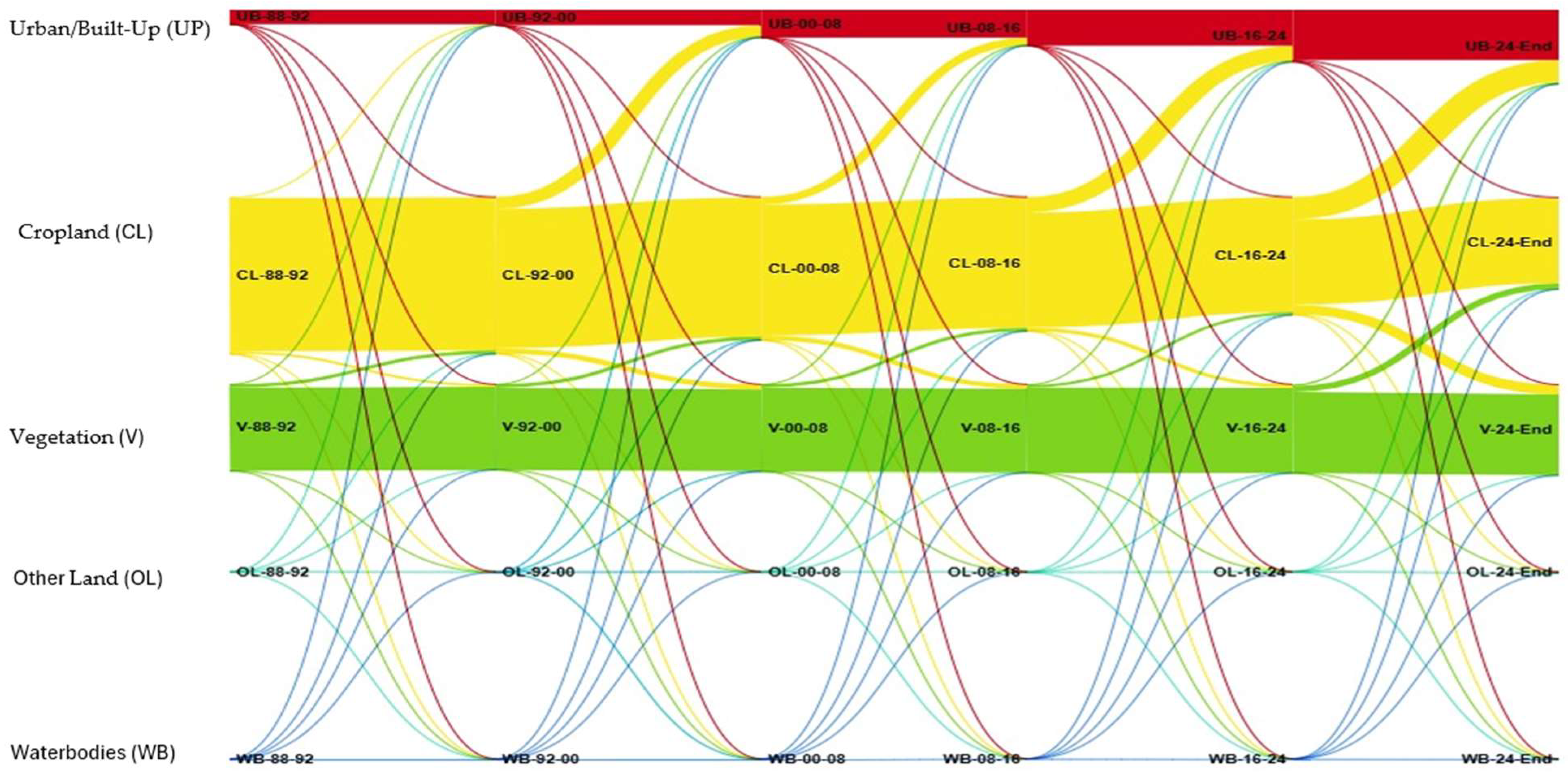
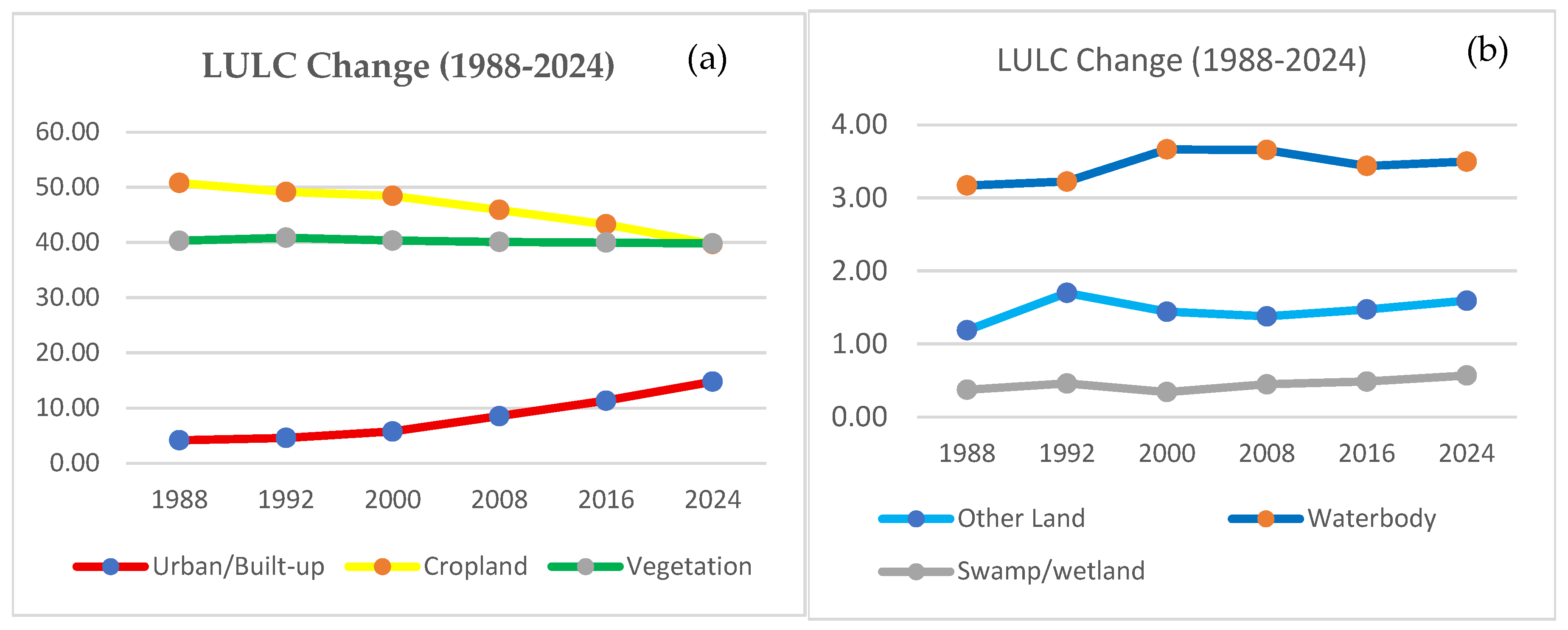
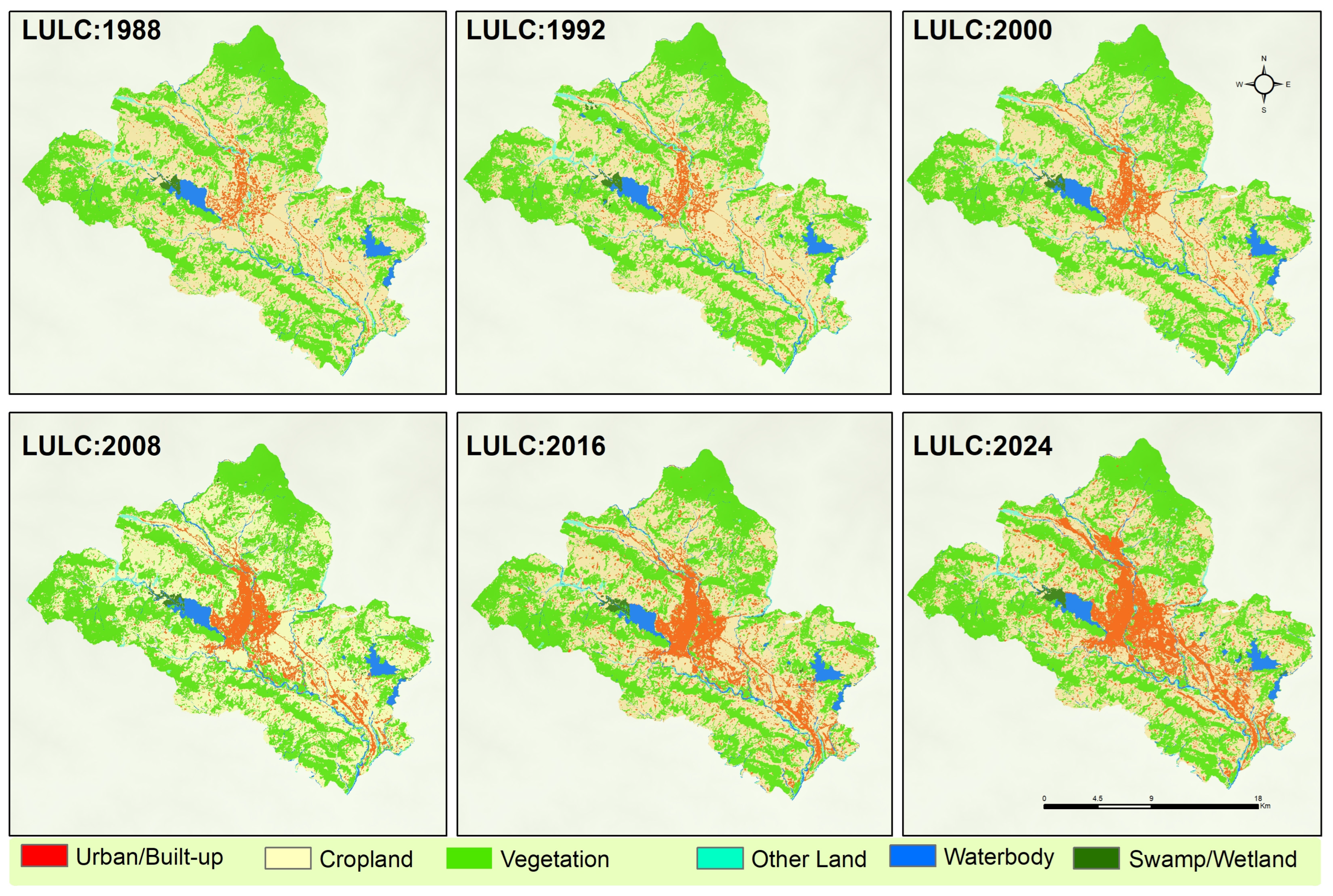
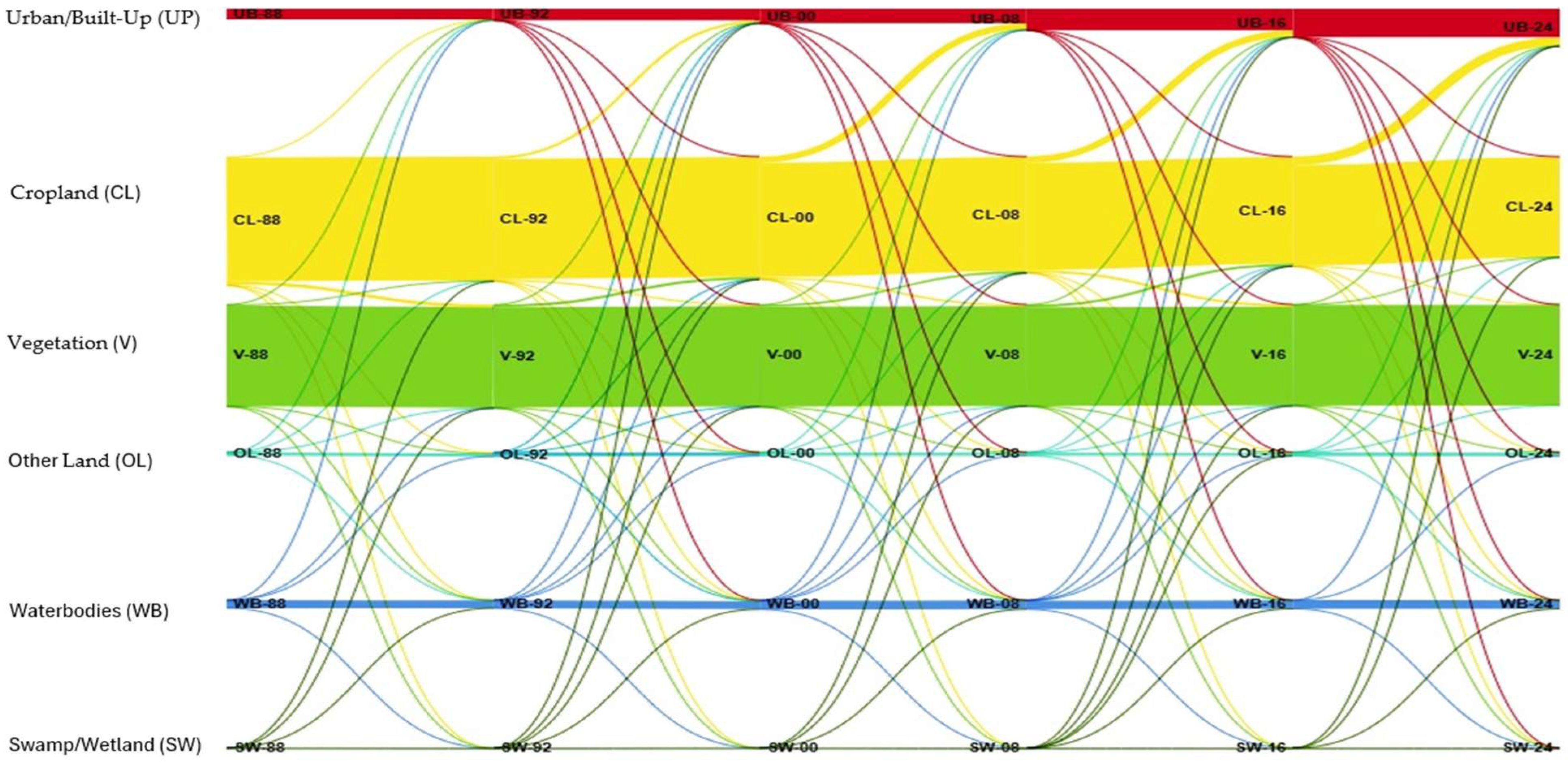


| Data | Data Sources |
|---|---|
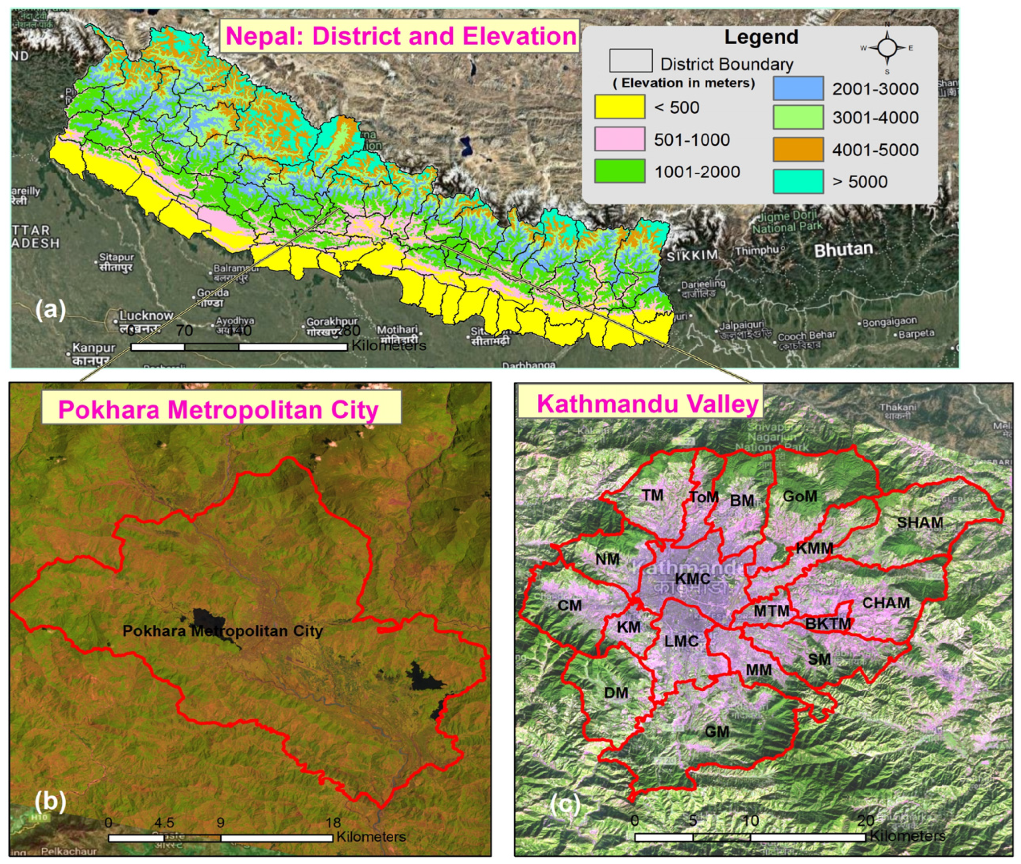
| Dates of the Landsat time-series 5, 7, and 8/9 images TM; ETM+; OLI. | For the years 1988, 1992, 2000, 2008, 2016, and 2024 (https://earthexplorer.usgs.gov) |
| LULC classified data for references and use | [28,58] Land cover data of Kathmandu valley 1988 and 2008 were used from Sarif et al., 2020 [28]. |
| SRTM DEM 30 m | The Shuttle Radar Topography Mission (SRTM) obtained elevation data on a near-global scale (https://earthexplorer.usgs.gov) |
| Administrative Boundary, Road, and River | Survey Department of Nepal, and Open Street Map (OSM) (https://data.humdata.org/; https://download.geofabrik.de/ (accessed on 20 June 2025)) |
| LULC Types | Description |
|---|---|
| Other Land (OA) | Sand areas, river banks, cliffs/small landslides, bare rocks, and open spaces |
| Waterbody (WB) | Rivers, lakes/ponds, canals, and reservoirs |
| Vegetation Cover (VC) | Evergreen broad leaf forests, deciduous forests, scattered forests, low-density sparse forests, degraded forests, and mainly grass fields (dense-coverage grass, moderate-coverage grass, and low-coverage grass) |
| Urban/Built-up (UB) | Commercial areas, urban and rural settlements, industrial areas, government secretariat areas, museums, construction areas, traffic, airports, and public service areas (e.g., schools, colleges, and hospitals) |
| Cropland (CL) | Wet and dry croplands and orchards |
| LULC | 1988 | % | 1992 | % | 2000 | % | 2008 | % | 2016 | % | 2024 | % | 1988–2024 |
|---|---|---|---|---|---|---|---|---|---|---|---|---|---|
| sq.km | sq.km | sq.km | sq.km | sq.km | sq.km | sq.km | |||||||
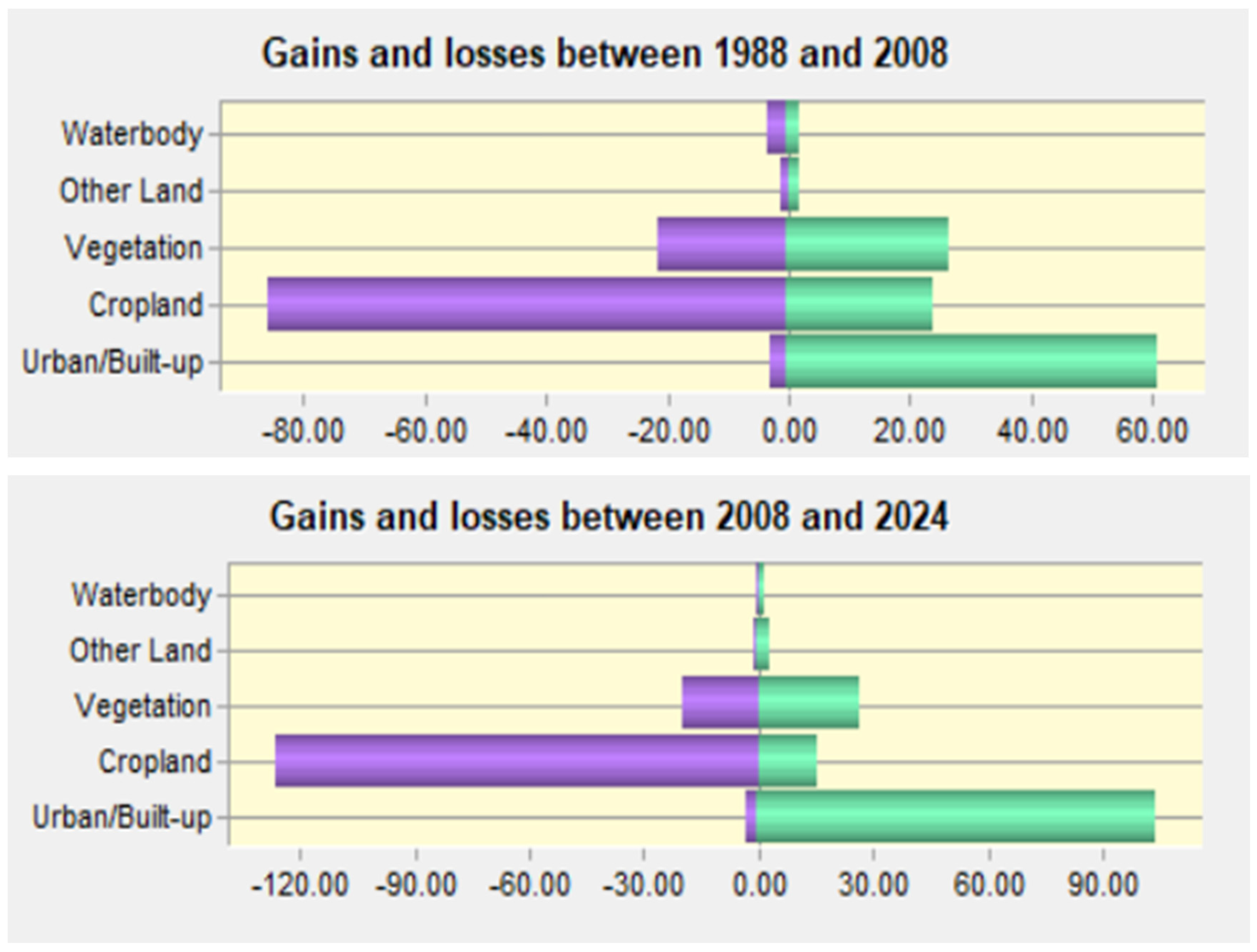
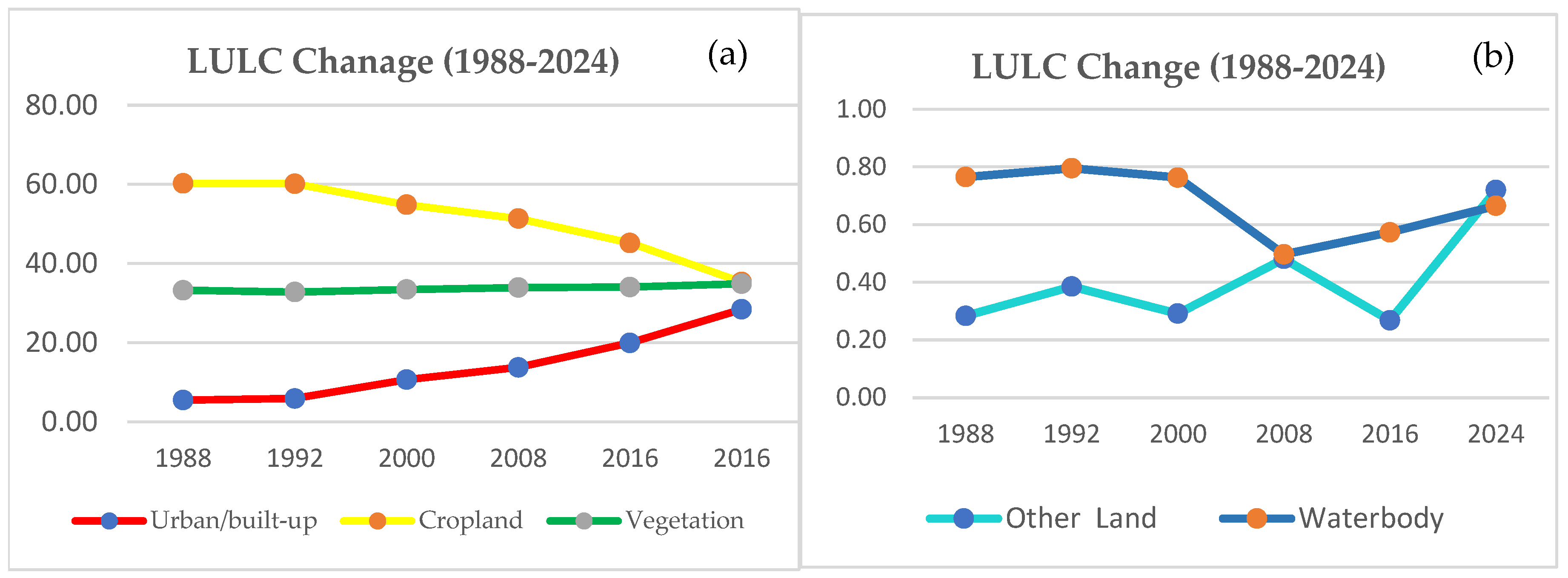
| Urban/built-up | 37.98 | 5.47 | 40.7 | 5.86 | 73.9 | 10.64 | 95.45 | 13.75 | 138.37 | 19.93 | 197.41 | 28.43 | 159.43 |
| Cropland | 418.32 | 60.25 | 417.7 | 60.16 | 380.91 | 54.87 | 356.63 | 51.37 | 313.78 | 45.2 | 245.08 | 35.3 | −173.24 |
| Vegetation | 230.69 | 33.23 | 227.67 | 32.79 | 232.13 | 33.44 | 235.4 | 33.91 | 236.27 | 34.03 | 242.17 | 34.88 | 11.48 |
| Other land | 1.97 | 0.28 | 2.67 | 0.39 | 2.02 | 0.29 | 3.34 | 0.48 | 1.86 | 0.27 | 5 | 0.72 | 3.03 |
| Waterbody | 5.31 | 0.76 | 5.52 | 0.8 | 5.3 | 0.76 | 3.45 | 0.5 | 3.98 | 0.57 | 4.62 | 0.67 | 0.69 |
| Total | 694.27 | 100 | 694.27 | 100 | 694.27 | 100 | 694.27 | 100 | 694.26 | 100 | 694.27 | 100 |
| Years | LULC | Urban/Built-Up | Cropland | Vegetation | Other Land | Waterbody |
|---|---|---|---|---|---|---|
| 1988–1992 | Urban/Built-up | 37.75 | 0.17 | 0.05 | 0.01 | 0.01 |
| Cropland | 2.58 | 407.56 | 6.26 | 1.14 | 0.78 | |
| Vegetation | 0.09 | 8.92 | 221.27 | 0.10 | 0.31 | |
| Other Land | 0.10 | 0.41 | 0.05 | 1.03 | 0.38 | |
| Waterbody | 0.17 | 0.64 | 0.04 | 0.40 | 4.04 | |
| 1992–2000 | Urban/Built-up | 40.42 | 0.09 | 0.13 | 0.01 | 0.05 |
| Cropland | 31.90 | 370.52 | 13.54 | 0.67 | 1.06 | |
| Vegetation | 0.14 | 9.33 | 218.03 | 0.11 | 0.05 | |
| Other Land | 0.94 | 0.45 | 0.17 | 0.83 | 0.29 | |
| Waterbody | 0.50 | 0.52 | 0.25 | 0.41 | 3.84 | |
| 2000–2008 | Urban/Built-up | 73.61 | 0.07 | 0.07 | 0.09 | 0.06 |
| Cropland | 20.48 | 347.51 | 12.19 | 0.62 | 0.11 | |
| Vegetation | 0.51 | 8.44 | 223.00 | 0.08 | 0.10 | |
| Other Land | 0.37 | 0.51 | 0.15 | 0.86 | 0.13 | |
| Waterbody | 0.48 | 0.10 | 0.00 | 1.69 | 3.04 | |
| 2008–2016 | Urban/Built-up | 95.13 | 0.10 | 0.14 | 0.07 | 0.02 |
| Cropland | 40.97 | 305.49 | 9.31 | 0.49 | 0.36 | |
| Vegetation | 1.67 | 7.33 | 226.40 | 0.01 | 0.0`1 | |
| Other Land | 0.50 | 0.62 | 0.34 | 1.28 | 0.60 | |
| Waterbody | 0.10 | 0.25 | 0.08 | 0.01 | 3.01 | |
| 2016–2024 | Urban/Built-up | 133.37 | 2.34 | 1.58 | 0.81 | 0.27 |
| Cropland | 59.45 | 226.50 | 25.53 | 1.62 | 0.68 | |
| Vegetation | 4.40 | 16.06 | 215.01 | 0.78 | 0.07 | |
| Other Land | 0.09 | 0.10 | 0.02 | 1.62 | 0.01 | |
| Waterbody | 0.10 | 0.09 | 0.03 | 0.17 | 3.59 |
| LULC | 1988 | % | 1992 | % | 2000 | % | 2008 | % | 2016 | % | 2024 | % | 1988–2024 |
|---|---|---|---|---|---|---|---|---|---|---|---|---|---|
| sq.km | sq.km | sq.km | sq.km | sq.km | sq.km | sq.km | |||||||
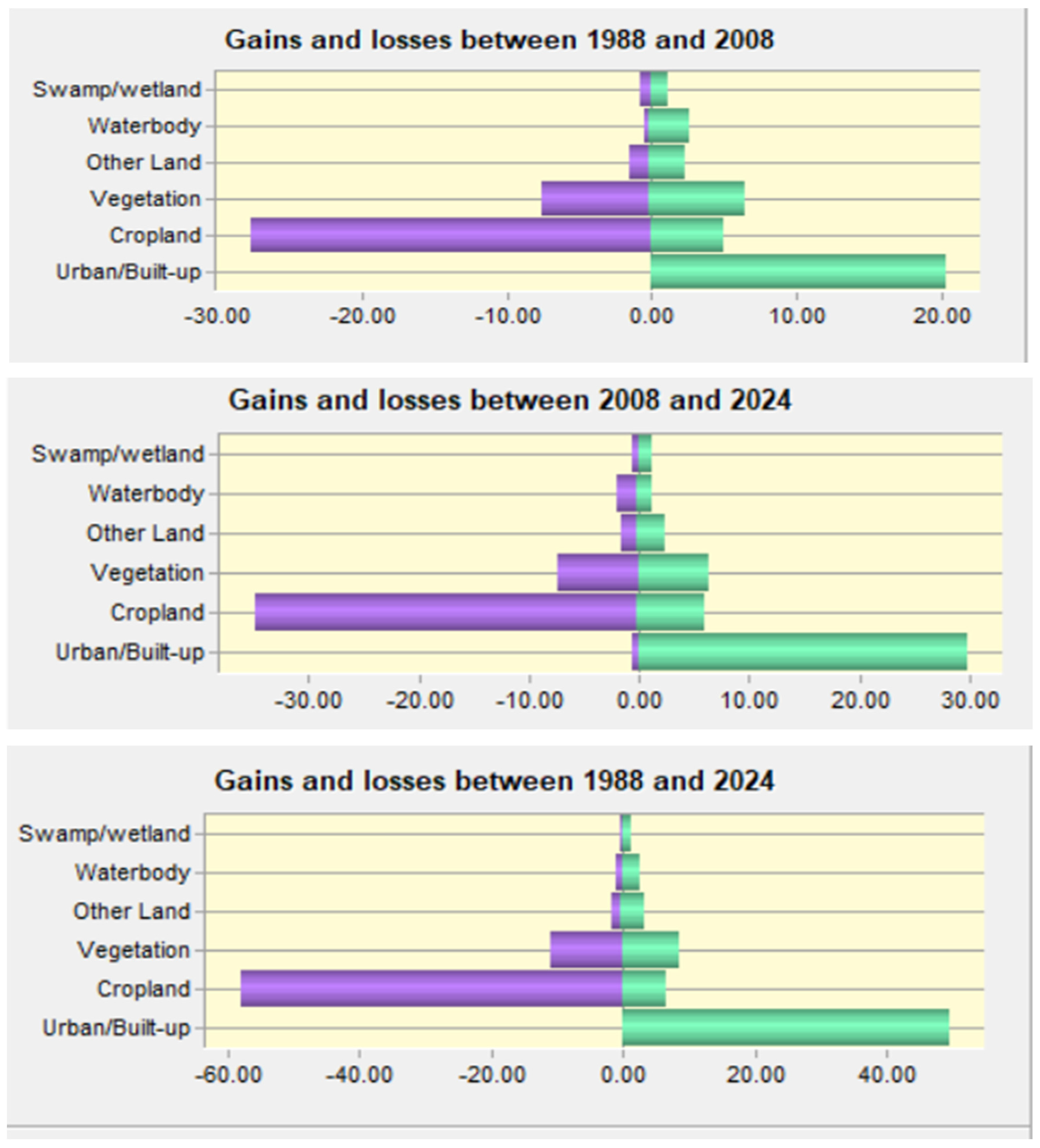
| Urban/Built-up | 19.42 | 4.18 | 21.37 | 4.6 | 26.76 | 5.76 | 39.62 | 8.53 | 52.68 | 11.34 | 68.68 | 14.79 | 49.26 |
| Cropland | 235.92 | 50.78 | 228.29 | 49.14 | 225.05 | 48.45 | 213.25 | 45.91 | 201.1 | 43.29 | 184.52 | 39.72 | −51.4 |
| Vegetation | 187.24 | 40.31 | 189.9 | 40.88 | 187.43 | 40.35 | 186.23 | 40.09 | 185.71 | 39.98 | 185.07 | 39.84 | −2.17 |
| Other Land | 5.51 | 1.19 | 7.89 | 1.7 | 6.69 | 1.44 | 6.39 | 1.38 | 6.83 | 1.47 | 7.39 | 1.59 | 1.88 |
| Waterbody | 14.72 | 3.17 | 14.97 | 3.22 | 17.02 | 3.66 | 16.98 | 3.65 | 15.96 | 3.44 | 16.24 | 3.5 | 1.52 |
| Swamp/Wetland | 1.73 | 0.37 | 2.12 | 0.46 | 1.58 | 0.34 | 2.07 | 0.45 | 2.25 | 0.48 | 2.64 | 0.57 | 0.91 |
| Total | 464.54 | 100 | 464.55 | 100 | 464.54 | 100 | 464.55 | 100 | 464.54 | 100 | 464.54 | 100 |
| Years | LULC | Urban/Built-Up | Cropland | Vegetation | Other Land | Waterbody | Swamp/Wetland |
|---|---|---|---|---|---|---|---|
| 1988–1992 | Urban/Built-up | 19.42 | 0.00 | 0.00 | 0.00 | 0.00 | 0.00 |
| Cropland | 1.66 | 226.36 | 5.82 | 1.84 | 0.16 | 0.05 | |
| Vegetation | 0.12 | 1.88 | 183.72 | 0.70 | 0.37 | 0.44 | |
| Other Land | 0.09 | 0.01 | 0.10 | 5.19 | 0.11 | 0.00 | |
| Waterbody | 0.08 | 0.00 | 0.19 | 0.14 | 14.29 | 0.01 | |
| Swamp/Wetland | 0.00 | 0.02 | 0.05 | 0.00 | 0.03 | 1.62 | |
| 1992–2000 | Urban/Built-up | 21.15 | 0.03 | 0.03 | 0.04 | 0.12 | 0.00 |
| Cropland | 4.52 | 219.80 | 3.06 | 0.21 | 0.54 | 0.17 | |
| Vegetation | 0.61 | 4.82 | 183.28 | 0.33 | 0.81 | 0.04 | |
| Other Land | 0.45 | 0.26 | 0.28 | 5.90 | 0.98 | 0.00 | |
| Waterbody | 0.03 | 0.03 | 0.34 | 0.20 | 14.35 | 0.01 | |
| Swamp/Wetland | 0.01 | 0.11 | 0.43 | 0.00 | 0.23 | 1.35 | |
| 2000–2008 | Urban/Built-up | 26.29 | 0.18 | 0.06 | 0.04 | 0.20 | 0.00 |
| Cropland | 11.44 | 209.20 | 3.22 | 0.21 | 0.15 | 0.83 | |
| Vegetation | 0.80 | 3.59 | 182.41 | 0.45 | 0.12 | 0.04 | |
| Other Land | 0.55 | 0.16 | 0.24 | 5.21 | 0.54 | 0.00 | |
| Waterbody | 0.54 | 0.07 | 0.15 | 0.48 | 15.75 | 0.03 | |
| Swamp/Wetland | 0.00 | 0.04 | 0.14 | 0.00 | 0.22 | 1.17 | |
| 2008–2016 | Urban/Built-up | 39.39 | 0.14 | 0.01 | 0.03 | 0.04 | 0.00 |
| Cropland | 11.84 | 195.55 | 4.51 | 0.58 | 0.24 | 0.51 | |
| Vegetation | 0.83 | 4.53 | 180.21 | 0.51 | 0.13 | 0.02 | |
| Other Land | 0.31 | 0.20 | 0.48 | 5.00 | 0.41 | 0.00 | |
| Waterbody | 0.31 | 0.18 | 0.42 | 0.71 | 15.12 | 0.23 | |
| Swamp/Wetland | 0.01 | 0.50 | 0.06 | 0.01 | 0.01 | 1.48 | |
| 2016–2024 | Urban/Built-up | 51.98 | 0.35 | 0.03 | 0.11 | 0.20 | 0.01 |
| Cropland | 16.07 | 183.56 | 1.00 | 0.35 | 0.08 | 0.04 | |
| Vegetation | 0.45 | 0.44 | 183.92 | 0.38 | 0.17 | 0.36 | |
| Other Land | 0.10 | 0.14 | 0.12 | 6.41 | 0.07 | 0.00 | |
| Waterbody | 0.06 | 0.00 | 0.00 | 0.14 | 15.64 | 0.12 | |
| Swamp/Wetland | 0.02 | 0.03 | 0.00 | 0.00 | 0.08 | 2.11 |
| LULC | 2024 Actual | % | 2040 Projected | % | 2056 Projected | % |
|---|---|---|---|---|---|---|
| Urban/built-up | 197.41 | 28.43 | 282.39 | 40.67 | 337.37 | 48.59 |
| Cropland | 245.08 | 35.30 | 161.86 | 23.31 | 110.59 | 15.93 |
| Vegetation | 242.17 | 34.88 | 242.2 | 34.89 | 239.28 | 34.46 |
| Other land | 5 | 0.72 | 3.82 | 0.55 | 3.59 | 0.52 |
| Waterbody | 4.61 | 0.66 | 4 | 0.58 | 3.44 | 0.50 |
| Total | 694.27 | 100 | 694.27 | 100 | 694.27 | 100 |
| LULC | 2024 Actual | % | 2040 Projected | % | 2056 Projected | % |
|---|---|---|---|---|---|---|
| Urban/Built-up | 68.68 | 14.78 | 93.17 | 20.06 | 114.15 | 24.57 |
| Cropland | 184.52 | 39.72 | 162.42 | 34.96 | 143.81 | 30.96 |
| Vegetation | 185.07 | 39.84 | 185.47 | 39.93 | 185.59 | 39.95 |
| Other Land | 7.39 | 1.59 | 6.33 | 1.36 | 5.44 | 1.17 |
| Waterbody | 16.24 | 3.50 | 14.77 | 3.18 | 13.4 | 2.88 |
| Swamp/Wetland | 2.64 | 0.57 | 2.38 | 0.51 | 2.15 | 0.46 |
| Total | 464.54 | 100 | 464.54 | 100 | 464.54 | 100 |
Disclaimer/Publisher’s Note: The statements, opinions and data contained in all publications are solely those of the individual author(s) and contributor(s) and not of MDPI and/or the editor(s). MDPI and/or the editor(s) disclaim responsibility for any injury to people or property resulting from any ideas, methods, instructions or products referred to in the content. |
© 2025 by the authors. Licensee MDPI, Basel, Switzerland. This article is an open access article distributed under the terms and conditions of the Creative Commons Attribution (CC BY) license (https://creativecommons.org/licenses/by/4.0/).
Share and Cite
Rimal, B.; Rijal, S.; Tiwary, A. Prediction of Urban Growth and Sustainability Challenges Based on LULC Change: Case Study of Two Himalayan Metropolitan Cities. Land 2025, 14, 1675. https://doi.org/10.3390/land14081675
Rimal B, Rijal S, Tiwary A. Prediction of Urban Growth and Sustainability Challenges Based on LULC Change: Case Study of Two Himalayan Metropolitan Cities. Land. 2025; 14(8):1675. https://doi.org/10.3390/land14081675
Chicago/Turabian StyleRimal, Bhagawat, Sushila Rijal, and Abhishek Tiwary. 2025. "Prediction of Urban Growth and Sustainability Challenges Based on LULC Change: Case Study of Two Himalayan Metropolitan Cities" Land 14, no. 8: 1675. https://doi.org/10.3390/land14081675
APA StyleRimal, B., Rijal, S., & Tiwary, A. (2025). Prediction of Urban Growth and Sustainability Challenges Based on LULC Change: Case Study of Two Himalayan Metropolitan Cities. Land, 14(8), 1675. https://doi.org/10.3390/land14081675


