Article

Cognitive and Structural Perspectives on a Traditional Terraced Rice Field Village: An Integrated Spatial Syntax Approach

Department of Architecture, College of Engineering, Pusan National University, Busan 46241, Republic of Korea
*
Author to whom correspondence should be addressed.
Land 2025, 14(8), 1634; https://doi.org/10.3390/land14081634
Submission received: 8 July 2025 / Revised: 29 July 2025 / Accepted: 11 August 2025 / Published: 13 August 2025

Abstract

Gacheon Village, a traditional rice-terrace community in Korea, possesses ecological, cultural, and anthropological significance but is confronted by population decline and loss of ecological function. This study investigates the interrelationship between space and human activities in a traditional village through an integrated approach involving a cognitive perspective and spatial syntax analysis. Using Lynch’s five image elements, we analyzed social and cultural meanings through cognitive maps and interviews with 25 indigenous people. We applied detailed tools of spatial syntax analysis to analyze quantitative structures associated with cognitive representations and confirmed that cognitive space and syntax analysis are mutually complementary. In particular, segment analysis revealed symbolic places that were not identified in the general axis analysis, and we confirmed that these places were based on sociocultural contexts. By encompassing the complex functions of cognitive space and the quantitative elements of syntax analysis, we hypothesize that meaningful insights into spatial characteristics and taking an integrated approach to qualitative and quantitative data can enable spatial interpretation beyond the limitations of existing studies. The results of this study can be used to establish sustainable urban planning and preservation measures that consider the cultural and environmental contexts of traditional villages.

Graphical Abstract

1. Introduction

1.1. Background and Objectives of the Study

Human activities have profoundly influenced the patterns, physical structures, and meanings of urban forms. Historically, political acceptance and regulation have played an important role in the formation of cities. However, they have essentially been determined by the way humans conduct social, cultural, and economic activities [1]. Through this process, the appearance of cities is constantly changing, and time, space, social meaning, and human cultural factors dynamically interact to form the urban environment [2]. Ultimately, the form of cities is like a “mirror” that reflects human behavior, culture, and social patterns, through which we can understand human lives, values, and past behaviors more deeply.
In this context, understanding the morphological structure of urban spaces formed by humans and the way they perceive them is crucial for the effective development and response of healthy and sustainable cities. This is because how people perceive and experience spaces can be a key factor in making a city feel friendly, safe, and convenient. For example, a city’s spatial structure that is not blocked and is organically connected provides residents with a sense of friendliness and safety, such as a comfortable base, and serves to promote a vast and interconnected social network [3]. On the other hand, top-down urban environments designed without considering human cognitive methods can often cause problems such as alienation, environmental stress, and reduced accessibility, which can act as factors that undermine the inclusiveness and sustainability of the city [4].
The ideal urban environment does not exist only in the plans of planners who are limited to physical space but also in the hearts and minds of the people who live there [5]. Therefore, it is necessary to recognize that not only the urban environment itself, but also human cognition and psychological space, play an important role [6]. Thus, understanding the connection between the morphological structure of a city and human cognition is an extremely meaningful starting point for establishing inclusive and sustainable urban planning and design strategies.
Based on this perspective, two main research approaches were considered in this study. First, we focused on how humans perceive the environment and explored the interaction between the structure of urban space and individual behavior. Second, we quantitatively analyzed the form and structure of the city and explored the relationship between the form of urban space and human behavior. Ultimately, these two approaches addressed fundamental questions regarding the effect of the urban environment on human behavior and how human activities shape the structure of the city. The common goal of these studies was to understand how the “hidden laws” and “social and spatial relationships” between the city and humans work.
Against this backdrop, this study has the potential to analyze the interaction between urban form and human activities from the perspectives of human cognitive and urban structures. In other words, the core goal of this study is to analyze the characteristics of urban environments from the “cognitive perspective of human perception of the environment”, while “tracking human activities and physical and social spaces from the morphological aspect of the city to comprehensively explore how these two aspects influence each other.”

1.2. Theoretical Background

The two major research methods related to this study are the pioneering theories of Kevin Lynch, who pioneered the empirical research method of exploring human cognitive space using hand-drawn sketch maps. In his seminal book The Image of the City, he identified five environmental image elements that govern human cognitive space [7]. Using the term image, he captured how city dwellers live in large and diverse urban environments [8]. He argued that each resident has a visual image of the city, and that this image forms the identity, structure, and meaning of the city [7]. His research became the basis for many subsequent studies. DGD Pocock emphasized that the cognitive space that humans recall not only has physical “meaning”, but it is also functional, social, and symbolic [9]. Kwan and Weber showed that physical factors are not the only factors that influence how individuals choose space [10], and Golledge and Stimson argued that the importance of paths and landmarks in urban environments determines the dominance of cognitive maps [11]. In other words, cognitive maps, which are like lenses that allow us to look into a cognitive space that contains the dynamics of human–environment relationships, summarize the ways in which people produce and experience space [12,13,14,15,16]. This research method and Lynch’s theory have been widely used as tools to explore the role and meaning of space and place for over 50 years [17].
The space syntax theory is a research method that emerged in the 1970s and comprises a set of theories and analytical techniques for understanding the relationship between space and society. This theory was developed under the leadership of Hillier and Hanson [18,19]. Space syntax is a technical approach that can describe and analyze spatial patterns at the architectural as well as urban levels, and examines how effectively environments function through an objective descriptive approach [20]. Hillier and Hanson hypothesized that people have the ability to read or understand various spatial arrangements and their meanings [19]. This attempt to understand how meanings of spatial environments are communicated ultimately shows that the two theoretical goals regarding “how humans perceive environments” are closely linked.

1.3. Literature Review

In the related previous studies that integrated these two theories, “readability” in Lynch’s context and “clarity” in spatial syntax analysis techniques were measured. Kim and Penn (2004) found that the syntax of spatial organization in real environments and the syntax of cognitive maps in spatial cognition were closely related, and argued that there was consistency in the results derived from cognitive maps and spatial syntax analysis [21]. Tuncer (2007) attempted to find a connection between the organization of spatial perception and clarity based on Kim and Penn’s method and argued that the way it was frequently described in cognitive maps was the most integrated axis in terms of syntax [22]. In other words, the clarity of spatial organization can be seen as a link that can affect spatial cognition.
However, previous studies have overlooked one fact. Space syntax analysis is useful for understanding how easily a real environment can be recognized in reality, and integration is an indicator of the importance and accessibility of the space. In other words, a path with high clarity in space syntax is likely to be recognized well in a real environment and is depicted frequently in cognitive maps. In addition, although these analysis methods have the strength of quantifying distance and spatial relationships, they have limitations in incorporating qualitative factors, such as society and culture, other than spatial context, with specific tools and quantification methods. Not only do representations in cognitive maps symbolically reflect various meanings, such as society, culture, and history, but emotions and feelings about a place are also shown as factors that affect cognitive processing [23]. Nevertheless, previous studies have focused only on capturing the interrelationships within the spatial context (space syntax) by quantifying cognitive maps and ignoring the potential influence of social meaning and symbolism [24]. Consequently, previous studies have successfully revealed the quantitative relationship between spatial structure and cognitive maps; however, in complex spaces such as traditional villages, an in-depth qualitative context in terms of cognition has not been sufficiently considered. This limitation may result in missing important meanings in understanding the identity of humans, the environment, and the cultural uniqueness of traditional villages. This study recognizes the importance of this qualitative context and approaches it by establishing an appropriate analytical method.

1.4. Methodological Framework

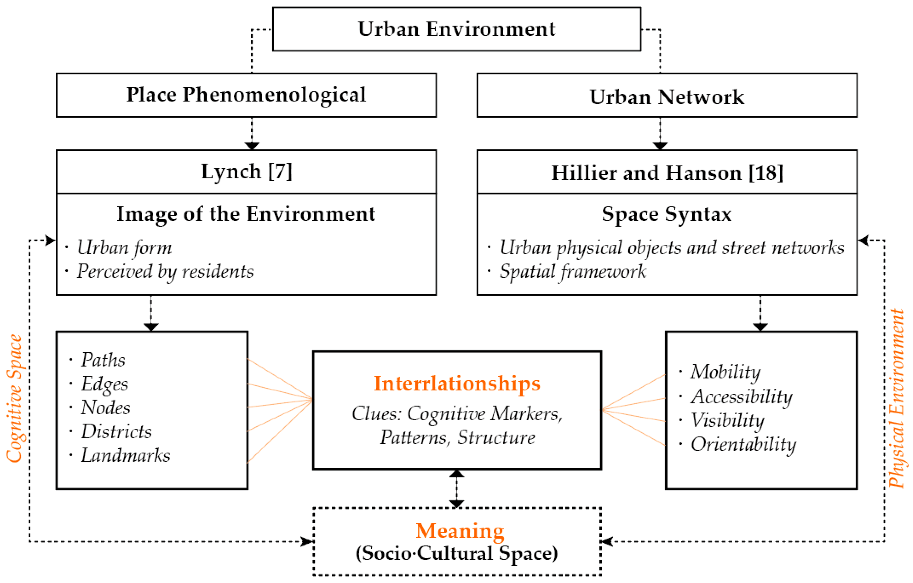
In this study, we built a framework that adopts a comprehensive perspective by leveraging the strengths of each methodology. A conceptual diagram of the study is shown in Figure 1. We aim to comprehensively understand the interaction between the environment and cognitive space by introducing an integrated methodology that systematically reflects social and cultural meanings beyond the limitations of existing research and simultaneously clarifies the potential connection between spatial relationships and meanings both quantitatively and qualitatively. Therefore, for technical indicators that are extremely clear or appear in space syntax, we first ask the following questions based on Lynch’s five image elements: “Which cognitive representations are interrelated with space syntax indicators?” and “Why do such representations operate in space structures?” If consistency is revealed in these relationships, we can expand the question to “What ‘meaning’ is related to which social and cultural factors (that previous studies have overlooked)?” Through this process, the main aim of this study is to explore new issues that previous studies have not addressed.
Specifically, based on Lynch’s research methodology, cognitive maps were obtained from participants; additionally, a comprehensive interview was conducted, where participants were directly asked about the meaning of the places shown in the cognitive maps. Consequently, the meaning of each place in social and cultural contexts was closely identified. These qualitative data were analyzed in conjunction with quantitative data based on the spatial syntax theory of the target area, and the complementary roles of these two theories were verified. In this process, to meet this research goal, tools such as correlation analysis and synthetic images were used to find answers to questions. Consequently, we traced the relationships and connections through mutual comparative analysis, and based on this, we explored the kind of social and cultural “meaning” that is implied. Finally, we drew conclusions from a perspective that comprehensively views the cognitive space and physical environment.

2. Study Area and Cognitive Map Analysis Approach

2.1. Site Analysis and Overview

Urban form is the sum of “manufacts” or “artifacts” [1]. As cities change continuously, these artifacts constitute transformations or are essentially revealed in land use, streets, or building patterns. Over time, urban change is influenced by technological, political, and social changes, and while some areas change more rapidly than others, others remain stable for long periods because of the collective memory of their inhabitants [1].
In this study, a traditional village that has been stably maintained through collective memory and has residents who have lived there for a long time was selected as the research site. The research site was Gacheon (terraced rice field) Village, located on Namhae Island, facing the Pacific Ocean at the southern tip of Korea. This traditional village is similar to historical sediments, where natural and human environments have accumulated over a long period.
The village is surrounded by mountain ranges on both sides and overlooks the sea. According to records, it is estimated that people have lived there for approximately 1300 years. Because of the rugged terrain, transportation was not developed for a long time, and thus, the old cultural heritage is well preserved. The terraced rice fields in the village, which are recognized as important, are spread out on a 45° slope starting from the sea, with 108 layers and 680 individual rice fields. The village has historical significance in terms of anthropology, and the terraced rice fields are a valuable example of the wisdom of human communities pursuing a life in harmony with nature. However, as in many villages in Korea today, the number of farmers is decreasing due to aging. Furthermore, the narrow and dangerous nature of the terraced rice fields makes it difficult to use agricultural machinery, which is lowering the agricultural productivity, thus making economic and social management difficult. These problems have made the future of the village uncertain. Undertaking in-depth research on the collective memories of residents who have lived there for such a long time and the structural and sociocultural values of traditional villages is a key and urgent task for regional development and cultural heritage preservation.
According to the written records and oral testimonies of residents obtained through interviews, Gacheon Village is said to have the shape of a Chinese character, “cheon: stream (川),” because there is a river flowing on both sides. This village is centered on agricultural land but faces the sea, and so has formed an interesting cultural heritage and folk beliefs. Residents perform rituals to the god of the sea and the god of agriculture, praying for a bountiful harvest and peace in the village. As can be seen in Figure 2, the story of the birth of the village in the shape of “stream (川)” is visually conveyed and reflected in its form. In addition, on the flat part of the village overlooking the sea, there are male and female rocks (the symbolic rocks) symbolizing the god of the sea, where rituals are performed to prevent marine accidents and pray for a bountiful catch. In addition, there is a stone tomb at the center of the village, which symbolizes the burying of rice (fresh), and there are similarly shaped tombs to the east and west, symbolizing the main ceremonial spaces of the village.

2.2. Participants and Spatial Meaning

Residents who have lived there for a long time have rich experiences and familiarity with the space, so they can provide more cognitive information and spatial awareness. In addition, we considered that they could more accurately grasp the relationships and meanings within the space based on the experiences accumulated in daily life, which enabled reliable analysis. Researchers such as Siegel have already confirmed that subjects with rich experiences show clearer spatial knowledge and location measurement ability [25]. Therefore, the participants selected for the survey were 25 indigenous people who were born and raised in the village for generations.
Currently, the village has a population of approximately 100. We visited 58 households in the village and selected 25 households, with one participant from each household, thus resulting in 25 research participants. During this process, we confirmed that, contrary to administrative records, some households did not reside in the village, or many houses were vacant; thus, the actual resident population was smaller. To ensure the reliability and depth of this study, it was important to select indigenous people with sufficient experience and awareness in the village, and thus, the number of subjects was naturally limited. All the participants drew maps of their villages themselves, and the researcher did not participate in the process of drawing the maps. There was no time limit for the work, and after the participants drew the maps, the researcher interviewed them face-to-face.
According to Lynch, the environmental image shown in a cognitive map is the result of the interaction between the environment and the observer (participant). The observer provides meaning to the map’s expression, thus explaining the strong structure and identity of the image owing to long-term familiarity [7]. Additionally, Boulding has defined the image as a product of experience, memory, and direct sensation [26], whereas Relph defines an image as one composed of the experience of an individual or group, the intention for the place, and all related elements, in addition to the image presenting the social distribution of knowledge about the place [27].
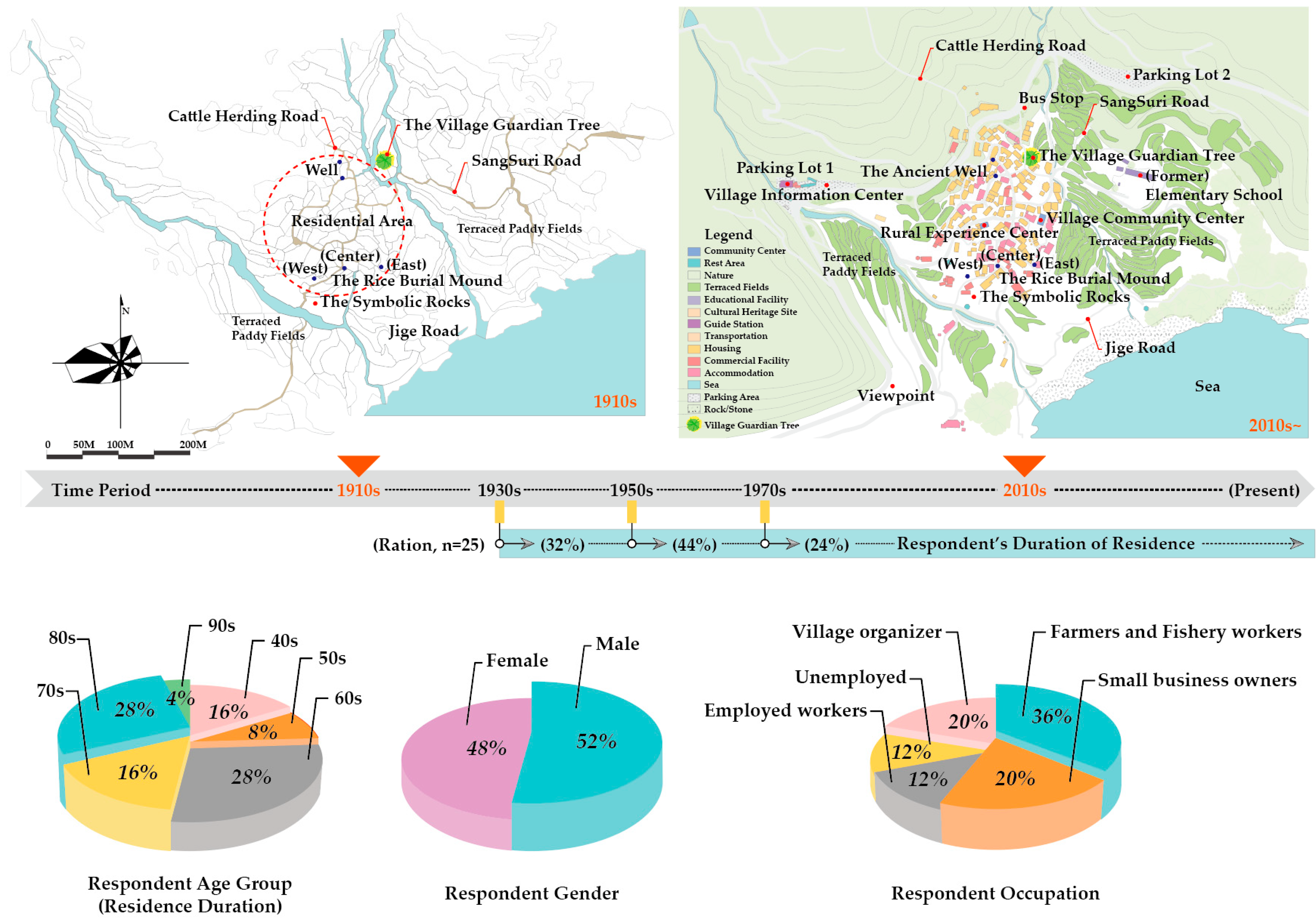
In this context, the researcher (outsider) recognizes that limitations exist in understanding the role and meaning of a space, merely through its physical form, function, or observable appearance. This is because understanding the actual values and identities that cannot be experienced as an insider is challenging. Therefore, we obtained the residents’ cognitive maps and conducted in-depth interviews to directly ask the participants about the various meanings of images revealed in the cognitive maps to understand the intrinsic meaning and identity of the place more comprehensively. The participants discussed their feelings, memories, genuine emotions, and the symbolic meaning of the image elements presented in the cognitive maps. The researcher recorded them to identify representations with shared social and cultural significance. During this process, the interview content was thoroughly recorded and repeatedly verified during the analysis phase. The researcher cross-checked the data several times to minimize the subjective interpretation bias that may occur during the interview process and performed a procedure to reconfirm the accuracy of the statements with the participants. The final extracted content was recorded on the village map (see Figure 3) and used for analysis.

2.3. Overview of Participant Characteristics and Cognitive Maps

The maximum and average ages of the participants were 92 and 70 years, respectively. As shown in the map in Figure 3, this includes people who remembered the scene in 1910. The gender distribution was balanced, and the occupation was mostly farming and fishing (36%) due to regional characteristics, and 20% remodeled their own houses to run accommodation facilities or shops selling local specialties. The other 20% were residents in charge of managing the village community.
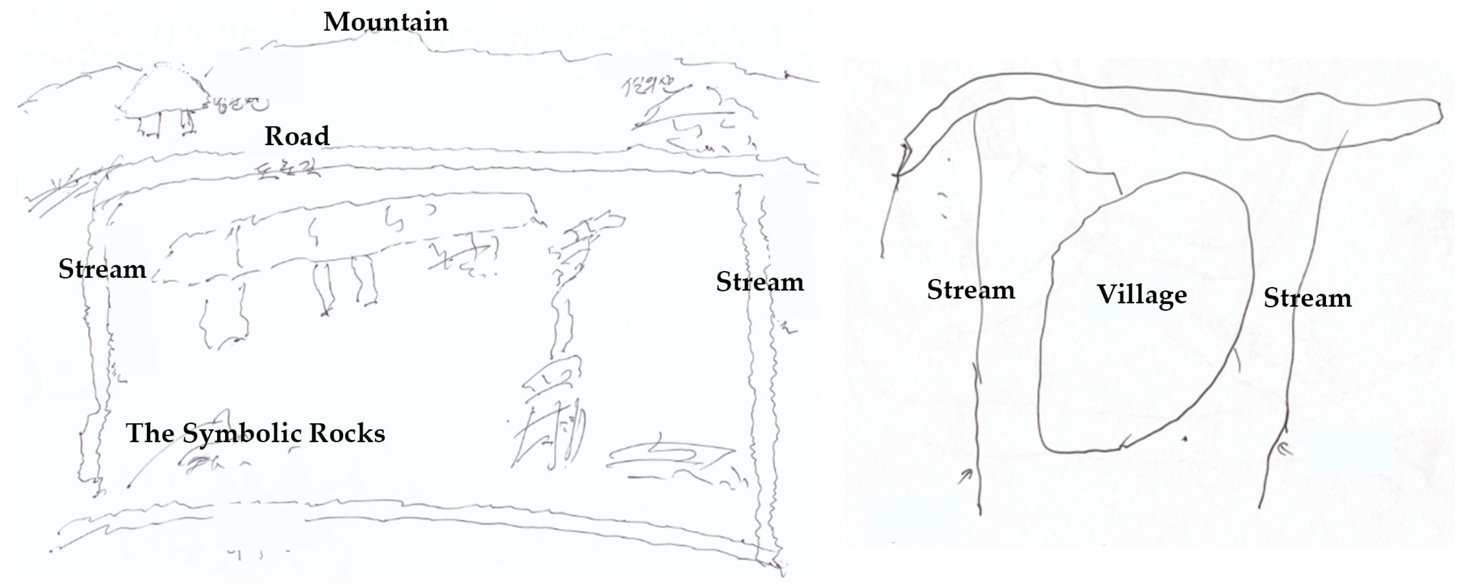
The data depicted in the collected cognitive maps were classified into five characteristic elements of the image (path, edge, region, node, and landmark), according to Lynch’s theory. As shown in Figure 4, some of the cognitive maps (approximately 14%) did not have any specific objects depicted and were composed only of abstract outlines of towns. In addition, the cognitive maps of each individual were fragmented and distorted, and showed differences in the sketching ability of participants. As this study did not evaluate the accuracy or quality of the cognitive maps, we focused on observing the frequency of occurrence of the image elements that generally appeared.

2.4. Cognitive Maps Analysis

The cognitive map shows various spaces and roads that reflect the experiences, cultures, and customs of the residents, including roads and spaces that are difficult for outsiders to understand.
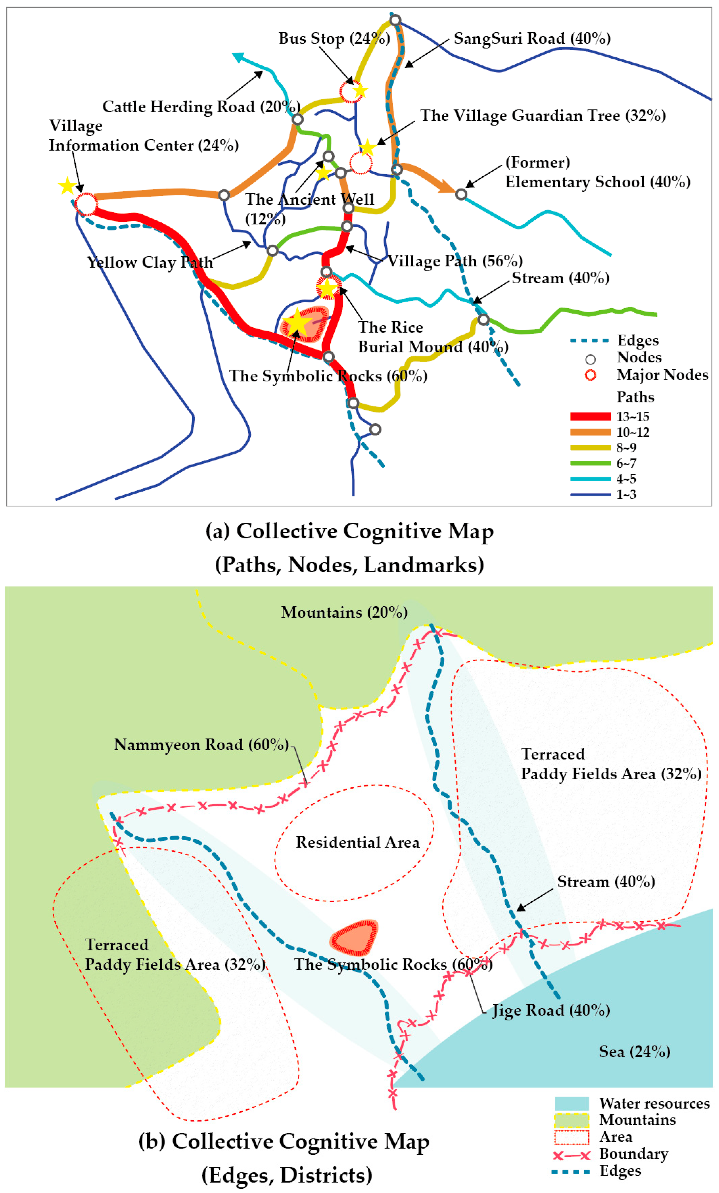
As shown in Figure 5, a collective cognitive map was constructed by overlapping 25 individual cognitive maps. We classified these five factors based on Lynch’s theory. We determined the line thickness based on its appearance frequency, displayed the appearance rate, and visually highlighted important elements, which facilitated the understanding of the diverse experiences and perceptions of residents at a glance. Subsequently, this map was used as fundamental data to analyze the detailed cultural contexts and spatial relationships.
Traditionally, the infrastructure related to terraced rice fields was the core living foundation of the village, and as a result, the role of “roads” for transporting crops and connecting living spaces was extremely important. The terraced rice fields formed on steep slopes were divided into “cow roads” for cattle and a “Jige (traditional carrying bag) Road” for people, and these roads functioned as core transportation networks and living infrastructure that effectively utilized the natural environment. However, in modern times, the role of existing rivers, wells, and traditional roads has gradually faded owing to the introduction of modern infrastructure such as water supply and ring roads.
Nonetheless, we can observe that the “Jige Road” that separates the sea and living space, the “ring road” that divides the mountain and living space, and the role of the stream in the overall (川) form are all important components that form the structure and organization of cognitive space.
The roads inside the village are intricately intertwined like threads, but they are richly depicted with major nodes recognized by residents. The nodes depicted in the cognitive map serve as places where people gather or as general passages [7]. Among them, major nodes that serve as intersections where people gather, such as bus stops, the village guardian tree, and old wells, are places with stories, and these spaces played an important role in understanding the structure and life history of the village. In particular, the guardian tree, which was traditionally planted at the entrance of the village, has long been symbolic of providing protection and good luck for the village residents. According to interviews, this tree is considered a place filled with childhood memories and recollections, a sacred space, and part of identity. As can be confirmed in the collective cognitive map, approximately 40% of the participants denoted a guardian tree that is actually a symbolic place located at the entrance of the village (before expansion). Likewise, the symbolic rocks have an effect similar to the “core” of the area, connecting with the abundance of the sea. In addition, the rice burial mound has the characteristics of a junction point. The areas in which these major nodes are formed also have symbolic landmarks. In this way, by utilizing the feature data of the image elements shown in the cognitive maps, the next section explores their interrelationship with the space syntax methodology.

3. Analysis of the Interspatial Relationships

3.1. Analysis Overview (Axial)

Hillier’s space syntax theory provides a technical method for quantitatively analyzing the relationship between urban structures and individual behavior. This current study emphasizes the point that the cognitive space structure and the technical approach of space syntax analyzed in Section 2 play a complementary role in exploring the relationship between urban structures and space based on human experience and behavior in depth. To examine the interrelationship between these theories more clearly, it is necessary to establish a general analytical framework that can view and approach the entire space. The practical methods generally used for road network analysis and spatial analysis are largely classified into three segments. Figure 6 show that, presents an example of a part of the village area that is the research target area in this study.
(a) The centerline map of the road was analyzed by considering the intersection as a single segment [28,29].
(b) The axis line was the most basic method for analyzing the distance and accessibility by providing a simplified two-dimensional road network. In other words, it was consistently expressed using the smallest number of axes with the longest visual field [30].
(c) The angular segment analysis was performed by calculating “the sum of angular rotations from the starting segment to another segment in the urban system” [31]. This was used to understand the change in the direction and connection structure of space in inner details by dividing the segment at the point where the axis line bends or changes direction.
(d) is the segment content shown in the cognitive structure in this study. The “axis” unit in the cognitive context needed to be approached from a different perspective from the existing space syntax method. In other words, it was confirmed that the “axis” in the cognitive structure and the “axis” that quantitatively approached the space had different characteristics. For example, in the cognitive space, there was a tendency to perceive an entire distance as a single cognitive axis that interacted with various environmental features, which was also related to the manner in which segmentation was applied.
Therefore, although the axis in the cognitive context and that in the space syntax methodology were structural roles that formed the connectivity of the road, there was a clear difference in their meanings and characteristics. The cognitive axis is a road or path that interacts with the environmental context of an individual and how it is perceived, and has subjective and organic characteristics related to environmental elements (nodes, landmarks, directionality, etc.), whereas the axis in the space syntax methodology is a unit that aims for a structural and quantitative analysis, and is closer to a simple geometric or quantitative abstraction of the length structure within the spatial network. Therefore, clearly distinguishing between these two concepts and understanding their differences is extremely important for a more precise interpretation of the cognitive and structural characteristics of cities and spaces.

3.2. Comparing Space Syntax and Cognitive Space

In the context of this study, it can be pointed out that previous studies have mainly limited spatial syntax analysis in real environments to data analysis using general axes. One criticism of the spatial syntax is that it does not sufficiently reflect the quantitative properties of mobility networks (flexibility) [32].
Therefore, in this study, in addition to the “axis” division structure commonly used in space syntax, we adopted the “segment” division method, which was designed to facilitate the understanding of changes and characteristics from more detailed and diverse perspectives. Additionally, we conducted a comprehensive analysis of various syntactic characteristics such as integration, intelligibility, and angular segments to understand spatial connectivity and structural characteristics. Subsequently, we applied the road network data of the cognitive maps based on the “segment” criteria and investigated their correlation with cognitive composition for each syntactic value. The depth map X (v0.8.0), developed by the UCL Space Syntax Research Institute, was used for this analysis. Statistical analysis was conducted using IBM SPSS software (v31), followed by data visualization and interpretation.
  • Axial Connectivity Analysis
Connectivity is an indicator of a spatial network structure that evaluates how closely each road or path is connected to the others. Van Nes defined main axes as routes with high structural connectivity, which people select to pass through and travel between urban areas [33]. Additionally, Humpert mentioned that this is related to the cognitive approach of the formation of an “ideal movement line” to a destination by pedestrians [34]. In other words, a central axis with many connected paths is theoretically evaluated as having high connectivity with the surrounding environment. Accordingly, this study aims to reveal the interrelationship between this structural connectivity and the core spatial network depicted in cognitive maps, and a connection analysis graph and the characteristics of nodes and landmarks in the cognitive space were synthesized.
Figure 7 shows that the highly connected central street of the village is an old street that has been used continuously since before the village was formed and expanded, suggesting that it has served as a key passage and the foundation of the village for a long time. In addition, the village guardian tree, which was located at the intersection when the village was first formed, is also located within a street with high structural connectivity. These streets have excellent accessibility, and thus commercial facilities are naturally concentrated there, and it can be confirmed that the male and female rocks, which play a strong “nucleus” role in cognitive space, are also adjacent to a street with high connectivity. However, the fact that the location of the center of the residents’ faith, such as the rice burial mound, was shown regardless of connectivity suggests that the arrangement of religious sites is based on perception, tradition, cultural factors, and meaning, and is separate from structural connectivity.
  • Visibility Graph Analysis
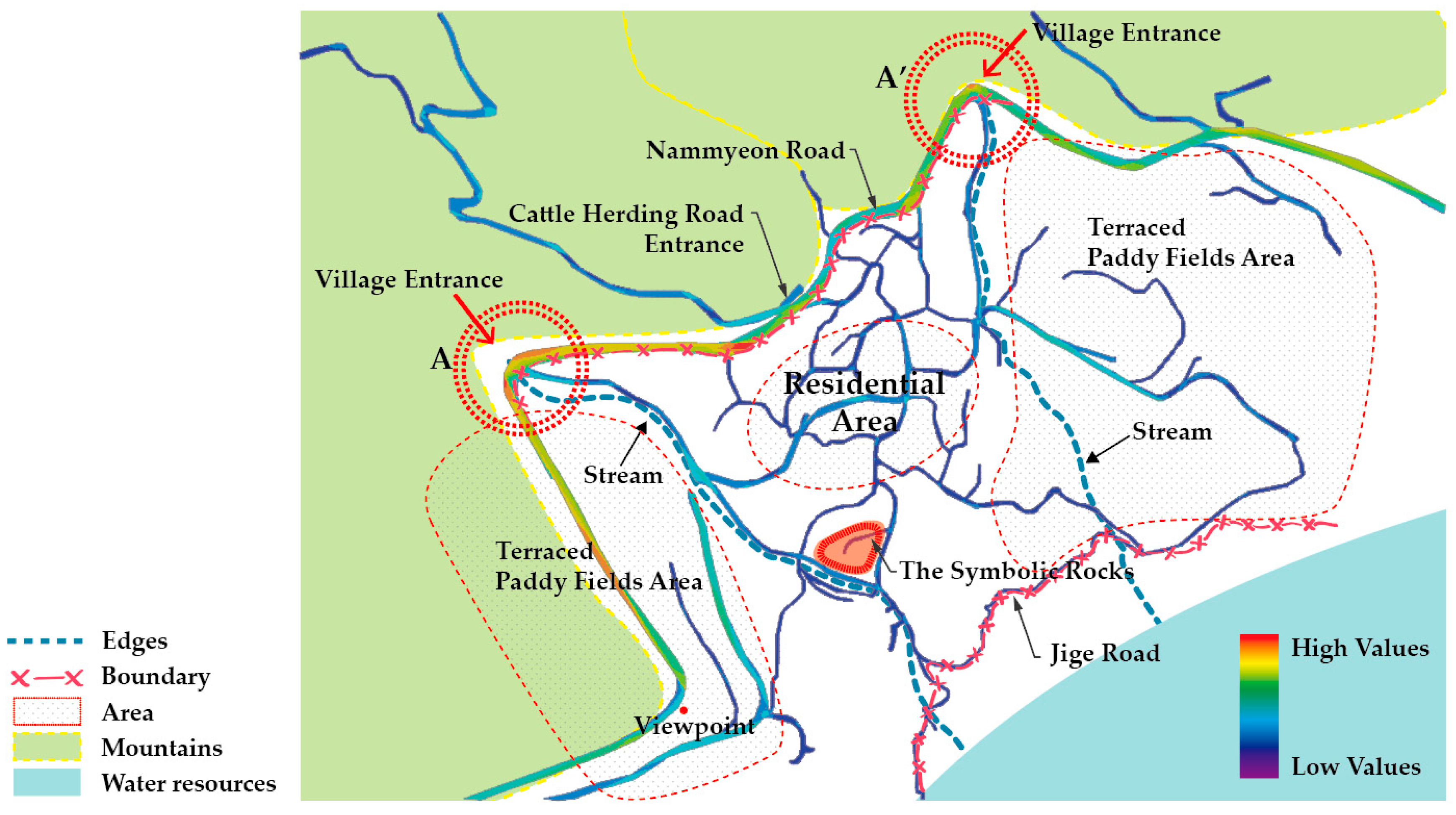
Visibility reflects the degree of approach to the visual axis and confirms the field of vision that can be penetrated. Visual connectivity enables securing a field of vision within a space. Thus, the boundaries and areas of the surrounding environment can be identified through the scope of the entire field of vision, which affects the cognitive structure. Based on this interconnectivity, we wanted to understand the areas and boundaries formed within the cognitive space in the visibility graph of the actual environment; Figure 8 is a composite that visually shows this relationship.
Typically, historical villages have a clear boundary between open spaces (public) and private spaces, forming a “strong” boundary, whereas “weak boundaries” are defined by the boundaries of trees, plants, fences, paved roads, and sidewalks. These boundaries widen the field of vision and minimize the route to the destination [35].
The study area in this research is an old traditional village. Although the physical boundaries are weak, the geographic altitude is high, the slope is steep, and the hierarchical terraced rice fields exist in a complex manner, creating a layered landscape with various visual structures. Based on this geographical background, as shown in Figure 8, Nammyeon Road is a naturally extended ring road along a mountain ridge and is located in a location with a wide field of vision and excellent views. The visibility graph confirms that the visual connectivity of this road has been strengthened. In terms of cognitive structure, it can be seen that this road plays a superficial role in dividing the village area.
On the other hand, the old road (Jige Road) bordering the sea has low visibility and connectivity in terms of syntactic indicators, but plays an important role in dividing the sea and the living area in the cognitive space. In addition, the (川)-shaped double-branched stream serves as a natural boundary separating the residential area of the village and the rice paddies (agricultural area), and although it actually starts from the mountain, it is perceived as starting from point A, A’ in cognitive terms. This point has a strong visual connection and serves as the entrance to the village.
The most central node of the village, the symbolic rocks, is located on relatively flat terrain and functions as an open space overlooking the sea, but its boundaries are unclear owing to trees, plants, etc. The narrow roads of the village form a continuous visual pattern inside, but there are limitations in analyzing the visual relationships of these roads, making it difficult to fully grasp the complex and multidimensional cognitive structure.
  • Axial Integration Analysis
Figure 9 synthesizes the features of the objects (buildings, places, etc.), nodes, and landmarks that appear in the integrated graph and cognitive space to identify their interrelationships.
In total, 188 axes were generated from the spatial syntax. Global and local integration analyses can estimate the ease with which a road accesses all other roads in a city system by considering the number of turns of city entities [36]. In other words, the spatial integration degree of axes can be determined.
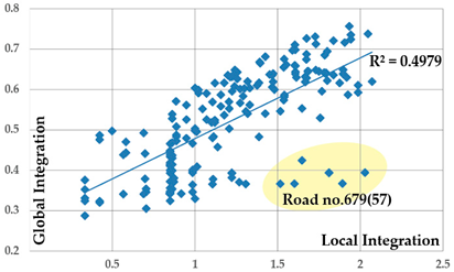
In the global integration evaluation, the central road (Road no. 679-8~17) with the highest connectivity showed the highest integration. For reference, Road no. 679 (57) is a remote road that is not frequently used by pedestrians. In the local integration evaluation, the symbolic rocks road (Honghyunli 849) and the central road (Road no. 679-10~17) were the most integrated.
Since local integration considered a spatial depth of radius 3, it was closely related to the composition of the actual environment that residents walk or use on a daily basis, and would help to understand the space based on residents’ road usage behavior. Therefore, from the local integration graph in Figure 9, we attempted to analyze the interrelationships by combining (c) objects, (d) major nodes, and landmarks that appear in the cognitive space. The analysis results showed that in the actual environment, stores were concentrated within streets with high connectivity and integration, but the representations (objects) that appeared in the cognitive space were often located at the endpoints or around streets with high levels rather than being directly adjacent to these streets. Major nodes and landmarks also played a role in dominating the cognitive space regardless of the level of integration.
This reveals that the representation of cognitive space was determined and distributed by residents’ memories and various factors rather than by the configuration of the physical environment, centrality of the network, or ease of movement. In particular, according to the interview results, in Figure 9c, objects were often related to stores of friendly neighbors or social community networks where personal attachments have been formed. In the case shown in Figure 9d, some objects existed in locations with excellent accessibility and connectivity, but symbolic places determined by various factors, such as long-term tradition and culture, did not always match the syntactic index. Major nodes and landmarks did not correspond to high integration. Instead, many nodes were distributed at intersections with low integration levels.
  • Axial Intelligibility Analysis
Table 1 shows that Intelligibility can be determined through correlation analysis of global and local integration. This indicates the degree of partial space that residents can directly experience and recognize within the overall street space structure. As a result of the analysis, the correlation coefficient was R = 0.706, showing a statistically significant relationship at a level where the p-value was less than 0.001 (two-tailed verification). The scatter plot graph generally forms a point cloud, but some data points were identified as outliers outside the distribution, which can be specifically confirmed as Road no. 679 (57). Unlike the strong correlation between structural connectivity and local integration, this street was likely to exist as a space that is difficult to recognize or remember in the actual environment. It seems that this is an extreme value that appears when it deviates from the general pattern in the analysis.
  • Angular Segment Analysis
Angular segment analysis is a detailed analysis method based on the angle of space that can capture the relationship between components and visual connectivity more precisely. On the other hand, conventional axial analysis mainly analyzes the relationships based on the axis line, and thus sometimes misses the complex visual patterns or detailed connectivity within the space. In particular, because angular relationships are closely related to the sense of direction in cognitive space, research results show that they have a significant impact on the way we find directions or navigate in and out of the environment. It has been revealed that people prefer large angles between 90° and 180°when changing directions and that small angles between 30° and 60° are easily lost owing to a lack of sense of direction [1]. Dalton concluded that people maintain linearity along a path with minimal angular deviation [37]. Based on this, by reading the graph configuration that quantifies the process of “selecting” a path and identifying the angles and visual connectivity of space, we can increase our understanding of how people form a sense of direction and select a path in cognitive space.
Applying various angle-selection analyses yielded the results shown in Figure 10. According to Hillier et al. (2007), a city has the dual characteristics of foreground (citywide or “global”) and background (local) street networks [38]. Therefore, the analysis comprised global and local (radius 3) analyses.
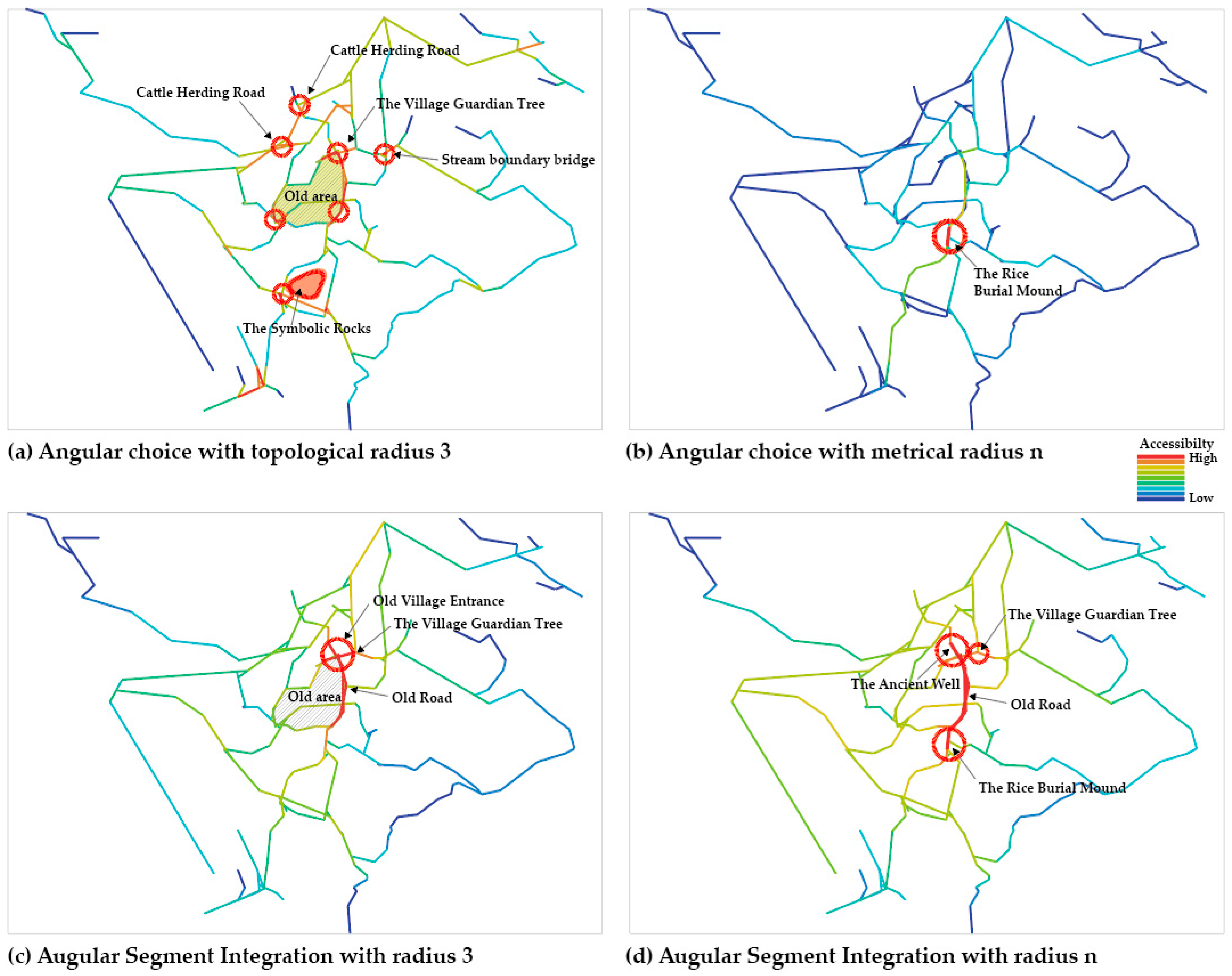
Figure 10a,b shows the angle-selection analysis with a phase radius of 3 and a metric radius of n, respectively. Figure 10c shows the most commonly used analysis, namely, the axis-integration analysis. The angle-selection analysis used a phase radius of 3. Here, the integration was calculated as the axis of each interval, changing direction three times [39]. Figure 10d shows an angle-interval–wide-integration analysis that emphasizes central structure and hierarchy.
The analysis results revealed a structural pattern in which the red-highlighted areas (high values) in the angular local integration (Figure 10a,b) matched the major nodes and landmarks in the cognitive space. In particular, the central highlighted area in Figure 10a is the old area that existed before the original living area of the village expanded. The village naturally expanded and changed along the geographical ridge and organization, but the original area served as an important foundation for its physical structure. Angular local integration with a metric radius of n yielded more sophisticated results than those obtained by axial local integration. As a result, the rice burial mound, which was not found in the previous analysis, was identified as the most important highlighted area. Figure 10c is similar to the integration of the axial line, but with an emphasized central space.
In the central structure and hierarchy shown in Figure 10d, the location of the rice burial mound, the well of the past (the center of life), and the guardian tree on the village road, which are symbolic spaces of the village, are consistent with the highlighted parts. Even in the midst of expansion and spatial change, the village could read spatial records of the past through spatial syntax, and their locations were consistent with the representations revealed in the cognitive space.
  • Results of the Correlation Analysis
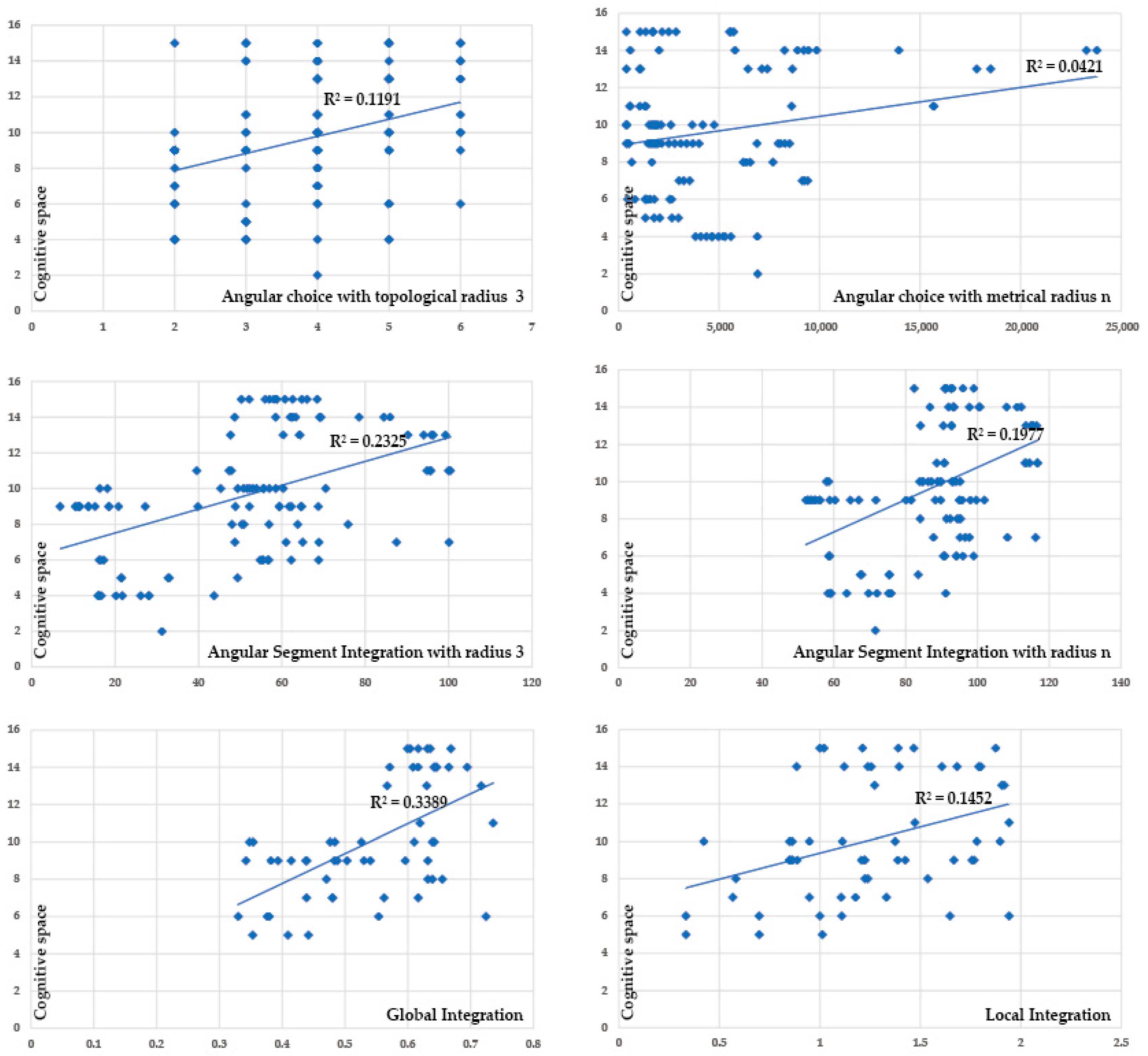
In this study, we performed a correlation analysis between the frequency of road appearance data in the cognitive map and data obtained from spatial syntax analysis. The spatial syntax values were analyzed using two methods: the general “axial” structure-based analysis and the “segment” structure analysis, which is a detailed method based on angles. Road network data from the cognitive map were applied using each analysis method, with 60 axial road networks and 117 segmented road networks. For the axis data, the correlation with two spatial indices, i.e., global integration and regional integration, was verified, and a correlation analysis was performed with segment integration, local integration, and other relevant indices in the same manner.
As shown in Figure 11 and Table 2, the analysis revealed that the global integral value of the axial road network exhibited the best correlation at r = 0.582, which was interpreted as the most significant result. The integral value obtained through the angle-selection analysis showed a significant correlation at r = 0.481.
However, the results of this analysis did not show a clear linear scattering pattern, as suggested by Kim [21]. The scatter plot shows a messy distribution of variables that seemed to be influenced by spatial characteristics, including dead ends and remote roads, similar to that observed in the study by Kim [21]. In particular, in the village where this study was conducted, there was a difference in the correlation between the lengths related to places such as the rice burial mound and symbolic rocks. In other words, in cognitive representation, all roads surrounding a place are recognized regardless of the integration or structural level, whereas in spatial syntax analysis, these roads are distinguished according to their hierarchical structure, which is why differences occur.
In addition, an angle-selection analysis was performed with a low radius to evaluate the cognitive role of the detailed path. This may be disadvantageous for a correlation analysis. However, it shows a high degree of agreement with the main nodes in the cognitive space, suggesting meaningful results for understanding road–network relationships.

4. Discussion

This study aims to elucidate the natural environment and spatial identity of Gacheon Village and to clarify the meaning of traditional villages as ecosystems that integrate nature and cultural practices. In response to the disappearance of agricultural areas and rapid population relocation experienced by Korea currently (a phenomenon whereby the residents relocate approximately once every six years, thereby causing the disappearance of the original inhabitants), we focused on analyzing the sociocultural values and spatial characteristics of a traditional village. Based on the results of this study, we suggest an optimal direction for spatial research.
First, based on a case study of Gacheon Village, we confirmed the effects of the natural environment and cultural characteristics on residents’ lives and spatial identities. For example, we confirmed that symbolic spaces maintained through religious rites that connect the sea and agricultural culture affect the continuous relationship between the natural environment and residents’ lives. This indicates that traditional villages are communal spaces that organically combine the environment, cultural heritage, and residents’ experiences as ecosystems. We hope that understanding the role of such spaces will serve as a starting point for sustainable urban and rural designs. Second, we systematized the method of integrating qualitative and quantitative data to include semantic and symbolic dimensions that cannot be easily captured via only the quantitative analysis of existing syntax and cognitive maps. Consequently, we confirmed that sophisticated quantitative syntax analysis values, past central streets, and core cognitive places are interconnected. Additionally, we discovered that the internal streets used by residents are important elements that reflect their lifestyles and cultural identities, which are not revealed to outsiders beyond simple structural elements. Accordingly, we aim to present efforts that encompass the sociocultural values recognized by each local resident, thereby addressing the extinction of the village ecosystem, increasing the sustainability of the local community, and deriving practical strategies for the spatial planning of traditional villages that consider resident-centered values.

5. Conclusions

5.1. Summary and Recommendations

This study attempts to contribute to the understanding of the impact of urban environments on human behavior by analyzing the interaction between urban forms and human activities from cognitive as well as structural perspectives. To this end, the relationship between urban structure and human cognitive space was explored from quantitative as well as qualitative perspectives, and the influences of the two perspectives on each other were examined comprehensively. From this study, the following conclusions were reached regarding the three key questions.
  • In the cognitive space, old central streets, the guardian tree, and the symbolic rocks function as highly symbolic representations and play key node roles. These elements have functioned continuously as key passages and foundations for the village since its past. Their locations and roles are also closely related to the structural connectivity of spatial syntax. Paths in the cognitive space show significant relationships in the axial analysis, and regional nodes show relationships in the detailed angular segment analysis. This is because past districts were revealed to be central through syntactic analysis.
  • In the cognitive space, roads that play the role of areas, surfaces, and important boundaries are often historical roads or a stream (in the form “川”) that are closely related to the lifestyle culture of the residents, regardless of visibility or syntactic level. This is because, historically, a living space based on the sea and agriculture, and the agricultural roads, livestock roads, and infrastructure related to terraced rice fields, have become the core foundation of residents’ lives. These roads and rivers function as “rivers” in the cognitive representation, and owing to the influence of this identity, they can play a symbolic role and function within the spatial structure. Therefore, the current spatial syntax technique alone has limitations in fully understanding the image elements (overall boundaries, organization, areas, etc.) that play a complex role in the cognitive structure, suggesting a comprehensive development direction.
  • Previous studies have mainly focused on axial analysis. This study applied a detailed tool-by-tool analysis of the spatial syntax method and found that the results showed a pattern in which high values coincided with core nodes. In particular, the angular selection analysis emphasized old areas and symbolic places, and the sophisticated syntactic analysis of metric radii was effective in revealing the location of the past central space and cognitive representations (belief space) that were not revealed in the axial analysis. These research results show that cognitive space is formed based on human semantic experience and behavior, and syntactic space analysis focuses on analyzing the structure and segmentation of the road network, and thus, there are limitations in perfectly reflecting the connectivity of the overall meaning.
These two methods are complementary because each has its own distinct strengths and limitations. Cognitive space is a representation that humans internally construct through experience and cultural meaning, reflecting deep and subjective meanings, whereas space syntax provides an objective analysis of physical structures, which is advantageous for quantitatively explaining the formation and organization of space. Therefore, an integrated approach of these two methods is essential for simultaneously understanding cognitive representations and structural characteristics. This is because richer and more reliable results can be obtained by allowing formal structures and human cognitive experiences to play complementary roles in precisely interpreting and designing complex and multilayered spaces.
This study is significant in that the integrated methodology used not only provides an important foundation for understanding the spatial records and cognitive representations of traditional villages but also suggests a new and integrated direction for spatial interpretation that connects human culture and the environment, past, and present.

5.2. Research Limitations and Future Works

In this study, we propose an integrated approach that combines the residents’ cognitive space with quantitative spatial syntax analysis while considering social and cultural meanings. However, our study presents several limitations. First, the limited number of 25 respondents and the dispersed age groups may have affected the representativeness of the sample. Second, the introduction of more objective and sophisticated analytical techniques is necessary for converting qualitative data obtained through interviews into quantitative data. Third, the syntax technical analysis method is limited. Currently, only the path data are cross-correlated, and a technical method that can verify the structural relationship by combining major spatial elements such as nodes and landmarks shown in the cognitive map should be prepared. Finally, because the cognitive map contains abundant cognitive network information such as phase, direction, and order, in addition to the five image elements, this information should be utilized in addition to the five image elements to enable a deeper understanding.
Additionally, to realize sustainable land use and ecosystem conservation, it is important to comprehensively understand the cultural and ecological characteristics of traditional villages and identify the relationship between human experience, cognitive space, and physical structure in a historical context. In this regard, a meaningful starting point must be identified for establishing sustainable design strategies. Thus, more precise and scientific methods should be developed, and more advanced, comprehensive spatial studies must be conducted.

Author Contributions

Conceptualization, Y.S. and J.Y.; methodology, Y.S. and I.L.; investigation, Y.S.; data curation, Y.S.; writing—original draft preparation, Y.S.; writing—review and editing, Y.S., J.Y., and I.L.; visualization, Y.S.; supervision, J.Y. and I.L.; project administration, J.Y.; funding acquisition, J.Y. All authors have read and agreed to the published version of the manuscript.

Funding

This work was supported by a National Research Foundation of Korea (NRF) grant funded by the Korea government (MSIT) (RS-2024-00344506).

Institutional Review Board Statement

This study forms part of a Korea and China global research network and Cooperative Program on spatial interpretation and social space in traditional villages. Participants in surveys and interviews were provided with a thorough explanation of the research, and personal information was not collected; data collected were used exclusively for this paper. The authors obtained permission from both the village committees and the local residents to conduct the study.

Informed Consent Statement

Informed consent was obtained from all subjects involved in the study.

Data Availability Statement

The data presented in this study are available on request from the corresponding author.

Acknowledgments

We thank the local residents of Gacheon village for their support for this study. The authors have reviewed and edited the output and take full responsibility for the content of this publication.

Conflicts of Interest

The authors declare no conflicts of interest. The funders had no role in the design of the study; in the collection, analysis, or interpretation of data; in the writing of the manuscript; or in the decision to publish the results.

References

  1. Nes, A.V.; Yamu, C. Introduction to Space Syntax in Urban Studies, 1st ed.; Springer Nature: Cham, Switzerland, 2021. [Google Scholar]
  2. Heathcott, J. Historic urban landscapes of the Swahili coast: New frameworks for conservation. In Report of the Historic Urban Landscape Workshops and Field Activities on the Swahili coast in East Africa; United Nations Educational, Scientific and Cultural Organization: Paris, France, 2011; Volume 2012, pp. 20–39. [Google Scholar]
  3. Moore, G.T. Knowing about environmental knowing: The current state of theory and research on environmental cognition. Environ. Behav. 1979, 11, 33–70. [Google Scholar] [CrossRef]
  4. Marcus, L.; Giusti, M.; Barthel, S. Cognitive affordances in sustainable urbanism: Contributions of space syntax and spatial cognition. J. Urban Des. 2016, 21, 439–452. [Google Scholar] [CrossRef]
  5. Blessing, C.A. Perception in planning. J. Am. Inst. Plann. 1960, 26, 2–4. [Google Scholar] [CrossRef]
  6. Harrison, J.D.; Howard, W.A. The role of meaning in the urban image. Environ. Behav. 1972, 4, 389. [Google Scholar]
  7. Lynch, K. The Image of the City; MIT Press: Cambridge, MA, USA, 1964. [Google Scholar]
  8. Jenkins, J.M.; Walmsley, D.J. Mental maps of tourists: A study of Coffs Harbour, New South Wales. GeoJournal 1993, 29, 233–241. [Google Scholar] [CrossRef]
  9. Pocock, D.C. The contribution of mental maps in perception studies. Geography 1979, 64, 279–287. [Google Scholar] [CrossRef]
  10. Kwan, M.; Weber, J. Individual accessibility revisited: Implications for geographical analysis in the twenty-first century. Geogr. Anal. 2003, 35, 341–353. [Google Scholar] [CrossRef]
  11. Golledge, R.G. Path selection and route preference in human navigation: A progress report. In Proceedings of the International Conference, COSIT ‘95, Semmering, Austria, 21–23 September 1995; pp. 207–222. [Google Scholar]
  12. Downs, R.M.; Stea, D. Image and Environment: Cognitive Mapping and Spatial Behavior; Transaction Publishers: Piscataway, NJ, USA, 2017. [Google Scholar]
  13. Gould, P.; White, R. Mental Maps; Taylor & Francis: Abingdon, UK, 1974. [Google Scholar]
  14. Hayden, D. The power of place: Claiming urban landscapes as people’s history. J. Urban Hist. 1994, 20, 466–485. [Google Scholar] [CrossRef]
  15. Milgram, S. Psychological maps of Paris. In The Individual in a Social World; Routledge: London, UK, 1992; pp. 88–113. [Google Scholar]
  16. Saarinen, T.F. Environmental Planning: Perception and Behavior; Houghton Mifflin: Boston, MA, USA, 1976. [Google Scholar]
  17. Gieseking, J.J. Where we go from here: The mental sketch mapping method and its analytic components. Qual. Inq. 2013, 19, 712–724. [Google Scholar] [CrossRef]
  18. Hillier, B.; Hanson, J. The Social Logic of Space; Cambridge University Press: Cambridge, UK, 1984. [Google Scholar]
  19. Dalton, R.C.; Hölscher, C.; Turner, A. Understanding space: The nascent synthesis of cognition and the syntax of spatial morphologies. Environ. Plan. B Plan. Des. 2012, 39, 7–11. [Google Scholar] [CrossRef]
  20. Hillier, B. Space syntax. A different urban perspective. Archit. J. 1993, 30, 47–63. [Google Scholar]
  21. Kim, Y.O.; Penn, A. Linking the spatial syntax of cognitive maps to the spatial syntax of the environment. Environ. Behav. 2004, 36, 483–504. [Google Scholar] [CrossRef]
  22. Tuncer, E. Perception and intelligibility in the context of spatial syntax and spatial cognition. In Proceedings of the 6th International Space Syntax Symposium, Istanbul, Turkey, 12–15 June 2007. [Google Scholar]
  23. Appleyard, D. The environment as a social symbol. Ekistics 1979, 45, 272–281. [Google Scholar]
  24. Evans, G.W. Environmental cognition. Psychol. Bull. 1980, 88, 259. [Google Scholar] [CrossRef]
  25. Kirasic, K.C.; Allen, G.L.; Siegel, A.W. Expression of configurational knowledge of large-scale environments: Students’ performance of cognitive tasks. Environ. Behav. 1984, 16, 687–712. [Google Scholar] [CrossRef]
  26. Boulding, K.E. The Image: Knowledge in Life and Society; University of Michigan Press: Ann Arbor, MI, USA, 1961. [Google Scholar]
  27. Relph, E. Place and Placelessness; Pion: London, UK, 1976. [Google Scholar]
  28. Hillier, B. Studying cities to learn about minds: Some possible implications of space syntax for spatial cognition. Environ. Plan. B Plan. Des. 2012, 39, 12–32. [Google Scholar] [CrossRef]
  29. Bruyns, G.; Nel, D.; Higgins, C.D.; van Nes, A. Flat versus volumetric methodologies: Restructuring spatial analysis and other indices. In Proceedings of the 12th International Space Syntax Symposium, SSS 2019, Beijing, China, 8–13 July 2019. [Google Scholar]
  30. Turner, A. UCL Depthmap 7: From isovist analysis to generic spatial network analysis. In New Developments in Space Syntax Software; Istanbul Technical University: Istanbul, Turkey, 2007. [Google Scholar]
  31. Turner, A. Could a road-centre line be an axial line in disguise. In Proceedings of the 5th International Space Syntax Symposium, Delft, The Netherlands, 13–17 June 2005; Volume 1, pp. 145–159. [Google Scholar]
  32. Ratti, C. Space syntax: Some inconsistencies. Environ. Plan. B Plan. Des. 2004, 31, 487–499. [Google Scholar] [CrossRef]
  33. van Nes, A. Analysing Larger Metropolitan Areas. In Proceedings of the 7th International Space Syntax Symposium, Stockholm, Sweden, 8–11 June 2009. [Google Scholar]
  34. Humpert, K. Lauf-Spuren; Ed. Esefeld & Traub: Stuttgart, Germany, 2007. [Google Scholar]
  35. Trova, V.; Hadjinikolaou, E.; Xenopoulos, S.; Peponis, J. The Structure of Public Spacein Sparsely Urban Areas. In Proceedings of the 2nd International Space Syntax Symposiu, Brasília, Brazil, 29 March–2 April 1999; pp. 1–12. [Google Scholar]
  36. Hillier, B. Space is the Machine: A Configurational Theory of Architecture; Space Syntax: London, UK, 2007. [Google Scholar]
  37. Dalton, N. Fractional configurational analysis and a solution to the Manhattan problem. In Proceedings of the 3rd International Space Syntax Symposium, Atlanta, GA, USA, 7–11 May 2001. [Google Scholar]
  38. Hillier, B.; Turner, A.; Yang, T.; Park, H. Metric and topo-geometric properties of urban street networks: Some convergences, divergences and new results. J. Space Syntax. Stud. 2009; in press. [Google Scholar]
  39. Yamu, C.; Van Nes, A.; Garau, C. Bill Hillier’s legacy: Space syntax—A synopsis of basic concepts, measures, and empirical application. Sustainability 2021, 13, 3394. [Google Scholar] [CrossRef]
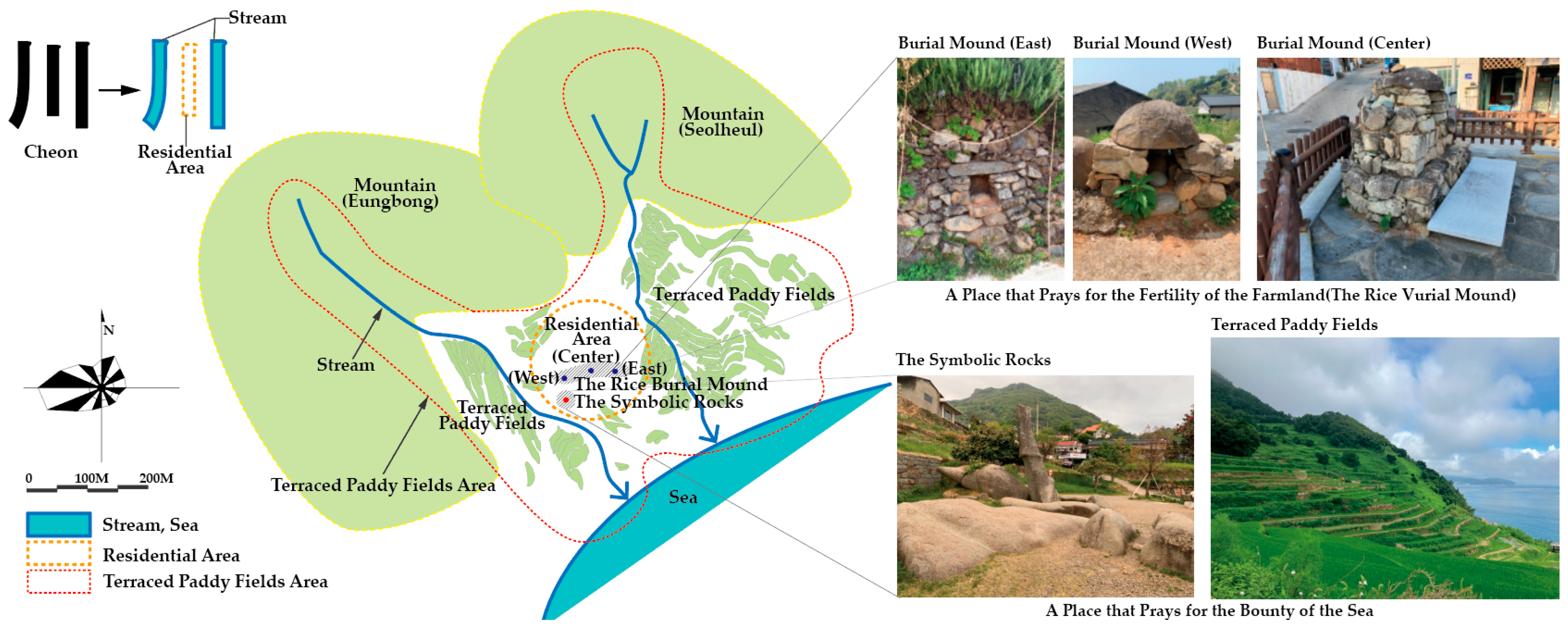
Figure 1. Framework of the research concept [7,18].
Land 14 01634 g001
Figure 2. Shape of the village (left), symbolic spaces of the village (top right), and terraced rice field landscape (bottom right).
Land 14 01634 g002
Figure 3. Village maps (1910s—top left and 2010s—top right) and pie charts showing the genders and occupations of the participants (bottom).
Land 14 01634 g003
Figure 4. Samples of the sketch maps created by the participants.
Land 14 01634 g004
Figure 5. Collective cognitive maps showing the image elements of (a) paths, nodes, landmarks, and (b) edges and districts.
Land 14 01634 g005
Figure 6. The various spatial representations of the street and road network. (Segments counted).
Land 14 01634 g006
Figure 7. Axial connectivity graph and cognitive spaces.
Land 14 01634 g007
Figure 8. Visibility graph analysis (VGA) graph and cognitive spaces (edges, districts).
Land 14 01634 g008
Figure 9. Axial integration analysis and cognitive spaces (nodes, landmarks, map buildings).
Land 14 01634 g009
Figure 10. Segment analysis and cognitive spaces.
Land 14 01634 g010
Figure 11. Scatter plot (spatial syntax and cognitive space).
Land 14 01634 g011
Table 1. Analysis of the correlation of intelligibility.
Syntactic PropertiesPearson’s r
Global Integration/Local Integration0.706 **
** p < 0.001
Land 14 01634 i001
Table 2. Pearson correlation between spatial syntax indices and path frequency in cognitive maps.
Syntactic PropertiesPearson’s r
Axial
Analysis
Cognitive Space/Global Integration0.582 **
Cognitive Space/Local Integration0.381 **
Segment
Analysis
Cognitive Space/Angular Choice with topological radius 30.345 **
Cognitive Space/Angular Choice with metrical radius n0.205 *
Cognitive Space/Angular Segment Integration with radius 30.482 **
Cognitive Space/Angular Segment Integration with radius n0.445 **
* p < 0.05, ** p < 0.01.
Disclaimer/Publisher’s Note: The statements, opinions and data contained in all publications are solely those of the individual author(s) and contributor(s) and not of MDPI and/or the editor(s). MDPI and/or the editor(s) disclaim responsibility for any injury to people or property resulting from any ideas, methods, instructions or products referred to in the content.