Article

A Hybrid Model for Land Value Capture in Sustainable Urban Land Management: The Case of Türkiye

by
Nida Celik Simsek
1,*,
Bura Adem Atasoy
2 and
Semih Uzun
2
1
Department of Urban and Regional Planning, Yozgat Bozok University, Yozgat 66100, Türkiye
2
Department of Geomatics Engineering, Karadeniz Technical University, Trabzon 61080, Türkiye
*
Author to whom correspondence should be addressed.
Land 2025, 14(8), 1570; https://doi.org/10.3390/land14081570
Submission received: 5 July 2025 / Revised: 23 July 2025 / Accepted: 29 July 2025 / Published: 31 July 2025

Abstract

Like in many countries, the transfer of increased land value created by public actions without landowner contributions back to the public is under debate in Türkiye. Although various Land Value Capture (LVC) mechanisms are employed worldwide to finance infrastructure investments, no comprehensive system has been established in Türkiye for this purpose. In this study, an improved LVC model that integrates land value and development rights is proposed. This model, termed Hybrid Land Readjustment (hLR), is designed to ensure that land value increases triggered by public investments are returned to the public. To this end, existing Turkish value capture instruments with potential are examined. Under the proposed hLR framework, equal basic development rights are granted to cadastral parcels, parcel and building-block value maps are utilized, basic rights are adjusted according to land-value changes, and a portion of additional development rights is transferred to the public. A practical application scenario is provided to illustrate the model’s operation. The system is configured for seamless integration into Türkiye’s existing legal and planning framework, offering a sustainable mechanism for financing infrastructure and implementing zoning plans.

1. Introduction

Urban populations are concentrated in cities worldwide, particularly in developing nations, thereby escalating demand for transportation infrastructure and residential properties [1,2]. Urbanization, economic expansion, and changes in service provision have contributed to heightened land requirements. As a result, urban rent premiums have been conferred upon landowners.
In Türkiye, real property values have been rising due to land readjustment (LR), public investments, transport projects (e.g., Canal Istanbul), zoning changes, urban renewal, and infrastructure developments. Landowners have benefited exclusively from land value increases generated by public actions, and the absence of a comprehensive value capture mechanism poses a challenge to the sustainable management of urban land.
It is broadly believed that increases in property value resulting from public investment should be returned to the public [3,4]. The value recovered from landowners is intended to fund public welfare, ensuring shared benefits from communal efforts [5,6].
The Turkish LR system, like the Portuguese and Indonesian models, employs the contribution rate (CR) to allocate land for public spaces and to capture value increments arising from zoning plan changes [7]. However, reliance on area-based calculations within the Turkish LR methodology limits its capacity to reflect significant value capture from major infrastructure investments [8]. In particular, tools to recover infrastructure construction costs are not provided.
In Türkiye, property value appreciation is primarily recovered through taxation; alternative funding models often propose tax increases, but such measures are frequently met with public opposition [3].
Worldwide, private sector participation in infrastructure investment is increasingly employed to stimulate economic growth by sharing costs and risks [9]. In many cases, municipal land assets are sold; for example, China, Hong Kong, Ethiopia, and India all utilize land sales to finance infrastructure, and in China, land leasing alone funds more than half of urban projects [10]. The value-capture concept has been successfully implemented in Hong Kong and Tokyo as an infrastructure-financing mechanism [11]. However, user-financed infrastructure is hampered by political factors such as inadequate taxation in Türkiye. Consequently, the build-operate-transfer (BOT) model has been extensively employed—particularly for highways, which are projected to constitute 72.2% of BOT projects by 2035 [12,13]. Nonetheless, resource constraints for projects with limited revenue potential necessitate the mobilization of private capital to alleviate financial burdens, distribute risk, and improve operational efficiency. As emphasized in the Eleventh Development Plan Transport Report, alternative financing mechanisms are essential to mitigate the financial pressures associated with BOT arrangements.
The experience of numerous countries demonstrates that Land Value Capture (LVC) can support infrastructure financing [14]. For example, China captures value increases from infrastructure investment or additional development rights by selling public and private land parcels to developers [15]. In São Paulo, Brazil, air-rights sales serve as an LVC mechanism for local infrastructure funding, while in Taiwan, landowners contribute additional payments to LR projects based on the anticipated change in land values following implementation [16]. Beyond these cases, development-based LVC instruments—such as urban redevelopment schemes, land leasing, and joint development—are widely employed around the world.
Recent European Union targets such as ‘no net land take by 2050’ have driven the development of novel monitoring metrics. For example, ref. [17] propose ‘net land take’ indicators that enable cross-country sustainability comparisons. Ref. [18] demonstrates how Denmark’s Aarhus Ø revolving fund mechanism pre-finances infrastructure and recycles proceeds through land sales. Ref. [19] illustrates the adaptability of tradable development rights by examining developer obligations transplanted from Munich to the Czech Republic, underscoring the flexibility of hybrid land-value schemes. Furthermore, ref. [20] reviewed transferable development rights in Korean municipalities, highlighting the institutional preconditions for successful market-based approaches. Drawing on these examples, Türkiye’s context is then examined.
Unlike many countries, Türkiye lacks a comprehensive LVC system that integrates land value, development rights, and public investment costs. Although existing instruments—taxes, fees, and charges—are intended to return value to the public, none address these elements in a holistic manner.
A Hybrid Land Readjustment (hLR) model is proposed to transact land value and development rights so as to recover the urban rent generated by public investments. Building on this analysis, the hLR framework is illustrated through a practical scenario to demonstrate its novelty in coordinating planning and value capture.
Additional development rights are sold as a bonus without infringing on property rights, enabling public authorities to finance infrastructure with greater flexibility and to adjust urban areas rapidly under fiscal constraints, thereby ensuring more effective land-use policy implementation.

1.1. Theoretical Background of LVC

1.1.1. Funding Arrangements for Public Services

Infrastructure services in Türkiye—such as transport, communications, energy, and water—are classified as publicly owned under national law. Traditionally, these services have been financed and delivered by state-controlled public bodies, covering sectors ranging from agriculture to healthcare [21,22,23].
However, rapid population growth has placed increasing pressure on existing infrastructure and amplified the demand for diverse concurrent services [22]. As in many developing economies, financing these needs has proved challenging, prompting fundraising innovations. Since 1984, Türkiye has relied on off-budget funds and capital markets to bridge financing gaps, but this approach has strained the national budget [23]. Due to budgetary constraints and the need for specialized expertise, private investment in this sector has been increasingly encouraged, particularly in light of Türkiye’s tax limitations [21].
Public–private partnership (PPP) models have been employed to finance investments. By 2023, 270 PPP projects totaling USD 98.61 billion had been implemented [24]. Türkiye’s economic growth is heavily dependent on infrastructure investment, with transport accounting for 35 percent of public expenditure [22,25]. Railway projects, in particular, are subject to scrutiny due to high costs and efficiency concerns [26], necessitating data-driven investment decisions in light of Türkiye’s limited public funds [27].
Many countries, particularly developing economies, face infrastructure financing challenges and tax aversion, prompting the exploration of alternative mechanisms. Cities such as Hong Kong SAR, Tokyo, New York, Washington, DC, and London employ development-based LVC instruments to fund the construction, operation, and maintenance of transit systems. Similarly, Nanchang, Delhi, and Hyderabad are adopting comparable approaches for metro development [3].
In Türkiye, municipalities have historically recovered infrastructure costs—such as roads, water, and sewerage—through beneficiary contributions authorized by Act 2464. These fees, which are capped at 2 percent of taxable property value [28], generate less than 1 percent of municipal budgets and have proven inefficient [29]. Since 1985, LR has provided land for public spaces at no cost to authorities. However, Türkiye still lacks a dedicated LVC tool for comprehensive infrastructure cost recovery.

1.1.2. LVC Instruments

LVC harnesses land value increases resulting from public interventions, such as zoning changes and infrastructure investments, to benefit society [3,30]. It is a financing mechanism that enables municipalities to recoup value gains driven by land-use modifications or new infrastructure. The recovered funds are then allocated to public investments, particularly in transportation [3].
LVC plays a strategic role in urban planning by ensuring sustainable development and securing project funding [3,31]. Two broad categories of LVC instruments exist:
  • Tax- and fee-based methods, including property taxes and betterment charges, which levy contributions proportionate to value gains.
  • Development-based methods, which realize value increases through mechanisms such as the sale or lease of land, transfer of development or air rights, land readjustment, and urban redevelopment.
Development-based LVC is especially effective for transport financing, as it directly captures land value gains, provides a predictable long-term revenue stream, establishes clear links between value capture and specific projects, and allows for stakeholder input [3]. In contrast, tax- and fee-based approaches often encounter resistance due to opaque value assessments and unclear benefit explanations. Furthermore, direct LVC schemes require robust legal frameworks and well-defined valuation metrics to function effectively [32].
Interest in LVC instruments is growing worldwide, although their success depends on national institutional contexts, legal systems, and land-market characteristics [14,18,33]. Table 1 summarizes various LVC tools and objectives by country.
This study focuses on the positive effects of public investments on property values, while acknowledging that some interventions may have negative impacts (see Figure 1). A limitation of the study is its exclusive focus on value increases resulting from administrative actions.

1.1.3. Why Capturing Value Matters?

There is a growing international consensus that increases in property value arising from public interventions should be shared with the public [39,40,41,42,43,44]. In the absence of LVC, private landowners benefit disproportionately from value gains generated by urbanization [45]. LVC mechanisms address this imbalance by promoting a fairer distribution of costs and benefits and thus enhancing social equity. Economists broadly agree that a substantial portion of the value created by public investments ought to be recovered for public use.
The Turkish Constitutional Court has repeatedly affirmed in its judgments that land value increases should not be entirely appropriated by the public sector but should instead be shared equitably to protect landowners from excessive burdens [46].
Regulations that transfer property value increases to the public sector are designed to promote equity in taxation, internalize externalities, curb speculative investments, and support strategic urban planning [29]. The widespread adoption of LVC approaches in both developed and developing countries further underscores their effectiveness as infrastructure financing and land-use policy tools.

1.2. Current LVC Mechanisms in Türkiye

1.2.1. The Value Increase Share

The Value Increase Share, introduced into Zoning Law No. 3194 in 2020, is a fee levied in exchange for zoning plan amendments (density increases or changes in land use). The fee equals the difference between the pre-amendment and post-amendment plan values. At least two firms authorized by the Capital Markets Board conduct the valuation; thereafter, a municipal commission reviews their reports and determines the final share. Payment is required upon the first sale of the property or before the issuance of the building permit.
Municipal revenues from zoning plan amendment requests have been rising rapidly [4], and transferring the resulting land value increments to the public sector serves the public interest [46]. However, further research is required to assess the effectiveness of this recently implemented LVC mechanism in Türkiye, owing to the absence of standardized valuation guidelines, suboptimal implementation practices, and limited institutional capacity [14].

1.2.2. Contribution Fees for Municipal Expenditures

In Türkiye, municipalities levy a contribution fee on property owners to finance expenditures such as water, sewerage, and road maintenance. This fee is calculated based on the property’s tax value and becomes payable after the service has been provided, with a statutory cap of 2 percent of the assessed value. Established under the Municipal Revenues Law of 1981, this mechanism typically yields contributions that fall short of the actual increase in land value [14]. Consequently, its share of municipal revenues remains low—approximately 2.7 percent [47]. Political sensitivities, undervalued property assessments, and concerns about long-term financial sustainability have been cited as factors limiting revenue from these fees [29].

1.2.3. Land Readjustment

Zoning plans play a critical role in regulating land use. Agricultural land values, which increase only modestly prior to planning changes, rise significantly once development rights are allocated under a zoning plan. In Türkiye, land readjustment (LR) has served as a fundamental mechanism for transforming rural areas into urban ones. Originating in the Ottoman Empire era, LR practices were codified in Article 18 of Zoning Law No. 3194 and updated to their current form in 2020 [48].
In urban planning, LR is regarded as a tool to achieve more efficient and economical use of cadastral parcels [49,50,51,52,53]. Parcels are consolidated through the cooperation of property owners, and areas required for public spaces (roads, parks, etc.) and infrastructure are set aside. The increase in land value generated by these arrangements is then redistributed to property owners in the form of newly configured, more valuable parcels. LR is designed as a participatory approach that aims to benefit all stakeholders [54].
Under the current LR system, parcel areas are reduced according to a fixed contribution rate, but property owners receive development parcels of higher value. The loss of land area is intended to be compensated by the uplift in land value. However, several challenges remain. First, the Turkish LR framework does not establish a clear connection between pre-LR values, area deductions, and development-right allocations. Planning approvals and implementation occur at different times: zoning changes increase land value, while LR and infrastructure improvements complete the process. Second, area-based LR (abLR) applies identical deductions to all parcels regardless of their value, which can result in unequal development rights for parcels of equal area or unequal burdens for parcels of equal value. This disconnect creates inequity and underscores the need for reform [8,55]. In contrast, LR systems in countries such as Japan, Germany, Chile, and China incorporate value-based adjustments to ensure fairer outcomes [14].
In Türkiye, planning decisions have an increasingly pronounced effect on urban land values, with land readjustment (LR) notably accelerating these increases [56]. Substantial uplifts in land value are documented following LR implementation: in Taiwan, a 40 percent contribution rate has corresponded with 5–10-fold value increases, while in South Korea, a 55 percent rate has produced 4–6-fold gains [57,58]. In contrast, Turkish LR schemes have yielded more modest uplifts of 1.18–2.26 times the original value [55].
In Türkiye, the LR method stipulates a maximum legal contribution rate of 45 percent. This deduction is based on an anticipated minimum appreciation of 1.82 times the original parcel values [55]. Contributions for public infrastructure are provided through land area deductions in kind. Although empirical evidence indicates that actual value increases often exceed these projections [59], a portion of the uplift is not captured for public benefit. Consequently, the current LR system is criticized for its inequitable distribution, as value gains are not fully transferred to the public sector.

2. Materials and Methods

2.1. Proposed Mechanism: A Hybrid Model Based on the Change in Development Rights

The existing LR approach is criticized for failing to ensure equality at allocation, for not covering infrastructure costs, and for not returning value increases to the public [8,55,60,61,62,63,64]. To address these shortcomings and to align Turkish practice with value-based principles, a hybrid mechanism is introduced.
At the heart of this mechanism is a value-based model that allocates development rights by comparing parcel values before and after regulation. Its key conceptual and structural features focus on single-use scenarios—purely residential or purely commercial zones—to ensure clarity. The hLR framework is also capable of accommodating mixed-use developments: separate floor-area-ratio limits are assigned to each use (for example, one limit for residential and another for commercial), and use-specific capture rates are applied so that residential, commercial, and service components each contribute equitably to public value capture.

2.2. Proposed LVC Scheme: Hybrid LR (hLR)

This study adapts the traditional LR framework—on which zoning plan implementation in Türkiye is based—into a hybrid LR (hLR) model that integrates both land-value assessment and construction-right allocation. Unlike the classical abLR, the hLR model transfers development rights from existing parcels to newly formed building blocks in proportion to their relative values.
The hLR model comprises four main stages:
(i)
Preparation phase;
(ii)
Implementation phase;
(iii)
Distribution phase;
(iv)
Secondary zoning plan—making phase.
Each stage is designed to ensure that value increases generated by public investments are equitably captured and allocated, while maintaining legal certainty and operational clarity.

2.2.1. The Preparation Phase of the hLR

In the preparation phase, the primary zoning plan is developed for the project area in accordance with the hLR methodology. The following criteria are applied:
i.
Ownership analysis: Treasury land is designated for commercial uses (e.g., hotels, shopping centers) so that sales proceeds after LR can generate revenue for local governments and help fund infrastructure costs.
ii.
Zoning allocations: Land uses must address projected population needs—residential, commercial, green space, infrastructure and transport—in line with current legislation. Accurate population estimates are essential, as they determine requirements for roads, parking and commercial areas [65]. The primary zoning plan is therefore designed with high-density targets but low initial floor-area ratios (FAR), enabling increased density in the secondary plan to achieve cost recovery. Flexibility in FAR adjustments during the secondary zoning stage is fundamental, since cost recovery depends on the ability to increase development rights.
iii.
Definition of basic development rights: Unlike models such as São Paulo’s CEPAC or Porto Maravilha certificates, Türkiye’s Zoning Law No. 3194 does not explicitly define a “basic development right.” Internationally, a basic FAR is often set (e.g., 1–2 in São Paulo), with payments required for development above that threshold [36,66,67]. In Türkiye, maximum FAR values within zoning plans—typically ranging from 0.20 to 3, though reaching up to 11 in Istanbul—are established by law [68,69].
In unplanned areas, the Regulation on Zoning in Unplanned Areas limits construction to a 40 percent building footprint and up to three storeys. For example, on a 1000 m2 parcel, a 400 m2 footprint across three storeys yields a total built area of 1200 m2 (FAR 1.2). Under the hLR model, this implied basic FAR is allocated first to the newly formed building blocks and then apportioned to individual parcels to ensure an equitable distribution of development rights.
These criteria ensure that the primary zoning plan establishes a clear foundation for value-based redistribution in subsequent phases of the hLR process.

2.2.2. The hLR Implementation Phase

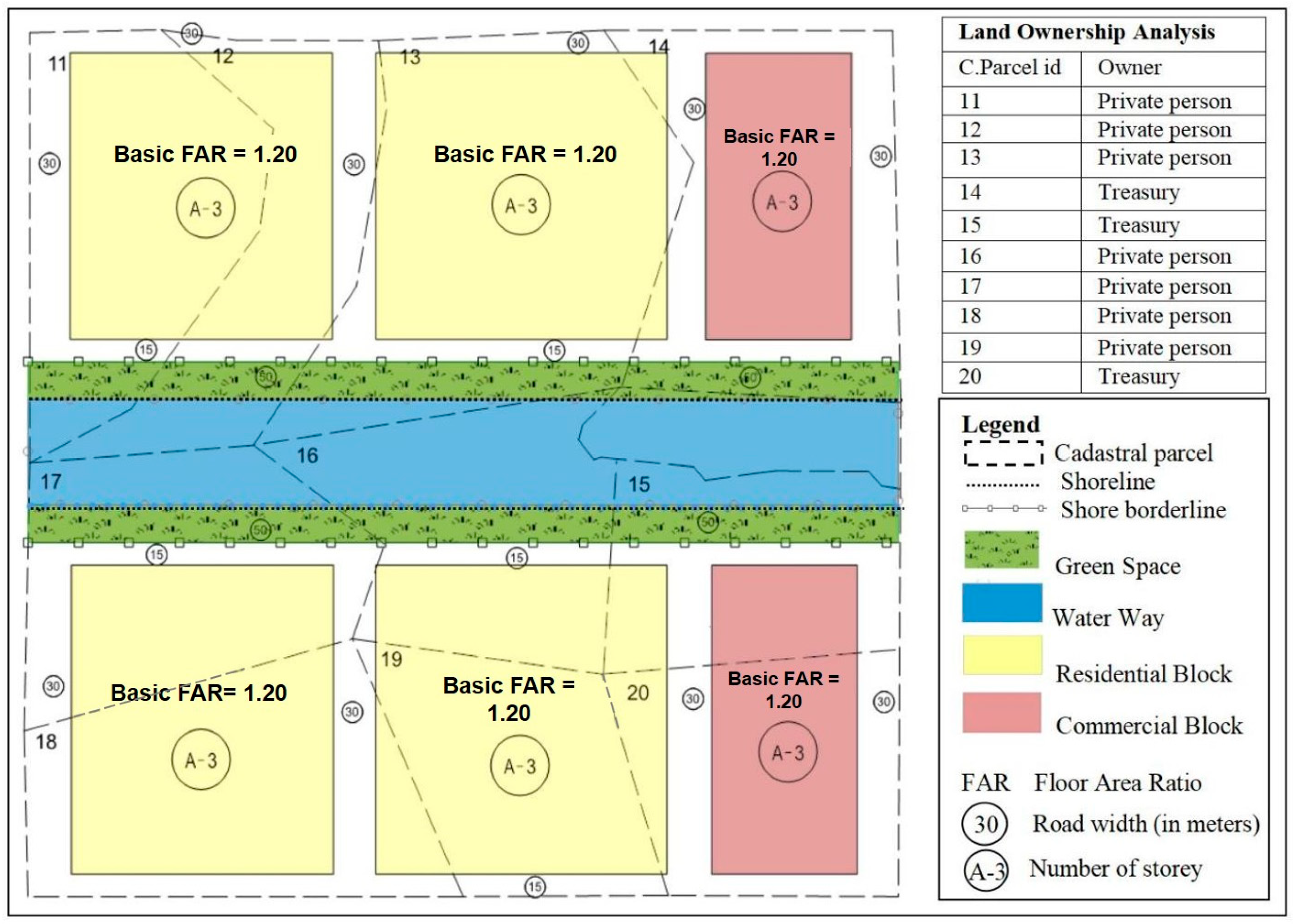
In the implementation phase of the hLR, the approved zoning plan is overlaid onto cadastral parcels to allocate basic development rights equally (Figure 2). The allocation process is transparent and does not depend on parcel size or value. Parcels designated for public infrastructure are excluded from the distribution, but their designation does not reduce the basic rights of remaining parcels. Under this phase, each parcel is granted the right to build up to 1.2 times its area, with a maximum of three storeys.

2.2.3. The hLR Distribution Phase

In the hLR distribution phase, two value maps are produced to underpin the uplift calculation and rights allocation: (1) a cadastral status map of pre-LR parcels and (2) a building-block map of post-LR lots.
The first value map, called the cadastral status value map, depicts the market values of pre-LR parcels within the project boundary, independent of development rights. The second map, the building-block value map, shows the values of post-LR lots subject to distribution. These two valuation processes draw on criteria established in previous value-based LR studies [55,62,63,64].
Once development rights have been allocated, the monetary uplift is calculated by comparing these maps, and the uplift amount is then allocated back to cadastral parcels and newly formed building blocks. The specific valuation criteria and methods are as follows:
(i)
Cadastral Status Value Map (Pre-LR Parcels)
(a)
Parcel type: Parcels containing buildings are valued as if undeveloped, with no consideration of anticipated zoning changes.
(b)
Valuation date: The date of the municipality’s formal LR implementation decision is used, and all market data observed prior to this date are included.
(c)
Valuation method: Market values are determined using the sales comparison approach.
(d)
Comparable selection: Comparables are selected from parcels within the same zoning plan that have not undergone LR.
(ii)
Building Block Value Map (Post-LR Lots)
(a)
Block type: Each newly created building block is valued as though undeveloped, with the provisions of the new zoning plan taken into account.
(b)
Valuation date: The date on which subdivision plans are approved serves as the cutoff for all valuation data.
(c)
Valuation method: Market values are established using the sales-comparison approach.
(d)
Comparable selection: Comparables are drawn from the set of building blocks formed under the approved LR subdivision, excluding any lots subject to further LR proposals.
(iii)
Payment Terms
To prevent immediate liquidity burdens on landowners, the fee schedule—based on the uplift between pre-LR and post-LR values—is communicated at plan approval. Landowners may defer payment until the property is sold or may opt to pay in instalments secured by an escrow arrangement. These provisions ensure that both existing parcels and their successor lots are valued consistently and that only the value uplift generated by the LR intervention is captured for public benefit.
(iv)
Benefits for Landowners
The hLR model is designed to secure public-sector value capture while also delivering direct advantages to landowners. Key benefits are as follows:
  • Fair share of uplift: Compensation is calculated transparently by comparing pre- and post-LR values.
  • Flexible payment terms: Payment may be deferred until property sale or made in instalments via escrow, thereby removing immediate liquidity pressures.
  • Tradable rights: Additional development rights are issued as a distinct asset that can be sold on secondary markets, enhancing owner liquidity.
  • Predictable development potential: Bonus FAR allocations are legally codified and recorded, providing planning certainty for future development.
  • Value enhancement: Public investments financed through hLR, such as infrastructure upgrades, further increase property values.
Following the identification of landowner benefits, the calculation of contribution shares under Turkish LR Law is presented in the next section.
(v)
Contribution Rate Ratio (CRR) and Distribution
After the cadastral status value map has been prepared, the Contribution Rate Ratio (CRR) is calculated. This ratio, mandated by Türkiye’s current LR legislation, ensures that an equal proportion of land area is deducted from each participating cadastral parcel. The CRR may vary depending on the characteristics of the regulation area, but a maximum deduction of 45 percent is legally permitted. The following equation is used to determine the deduction rate for each parcel (see Equation (1)):
C R R = C a d a s t r a l   l a n d   a r e a s B u i l d i n g   b l o c k   a r e a s C a d a s t r a l   l a n d   a r e a s
In this expression, the numerator represents the total area reserved for public infrastructure, and the denominator is the total area of all cadastral parcels within the LR boundary. The resulting CRR is applied uniformly to each parcel to derive its individual area deduction.
The new development rights for each building lot are calculated as follows (see Equation (2)):
N D R i = B D R × M V C P i M V B L i
Here,
  • NDRi: new development right of building lot i (new FAR);
  • MVCPi: market value of cadastral parcel i;
  • BDR: basic development right (basic FAR);
  • MVBLi: market value of building lot i.

2.2.4. The hLR Secondary Zoning Plan Phase

The primary objective of hLR is cost recovery without altering the location, size or functions specified in the original development plan. Increased development rights, granted as a density bonus [70], must be constrained by planners to match urban requirements. These bonus rights are then sold, resulting in higher permitted densities. The maximum construction limit remains aligned with the infrastructure standards of the initial plan, justifying the adoption of high-density zoning.
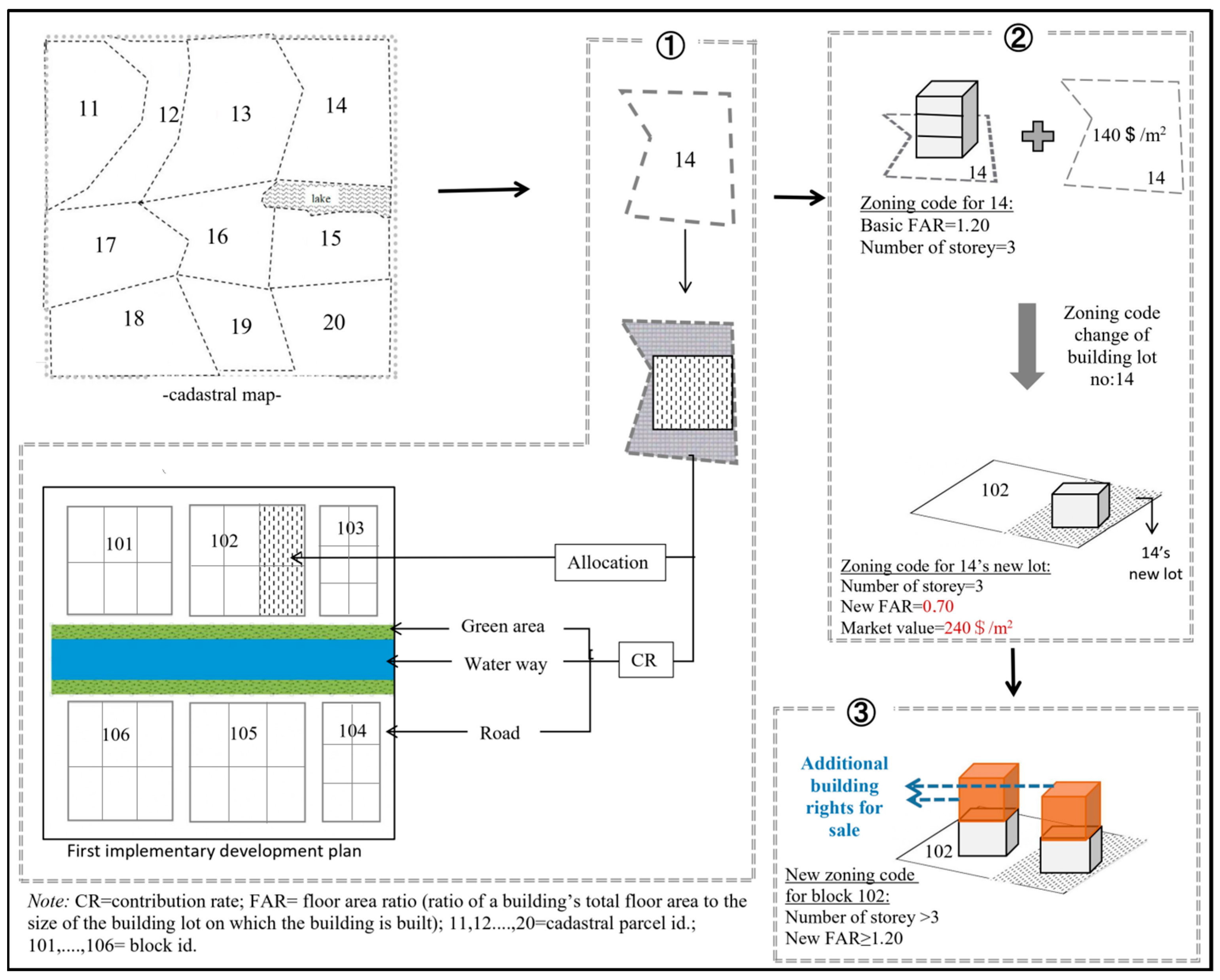
All urban functions are designed to the maximum allowable building density established in the primary zoning plan. Any additional development rights created under the secondary plan are transferred to the regulatory authority (see Figure 3➂). The sale of these rights, generated on the newly configured building sites, offsets a portion of project expenses, including construction, investment, infrastructure provision, and land subdivision.

3. Results

Application of the Model Through a Sample Scenario

The proposed LVC mechanism overcomes the limitations of existing Turkish tools that fail to recapture urban rent for the public. In this section, the operation of the hLR model is described in detail, and its working principles are illustrated. A realistic yet hypothetical application scenario—based on a financially unfeasible Turkish waterway project—is presented. Table 2 summarizes the planning parameters and hLR implementation features of this scenario.
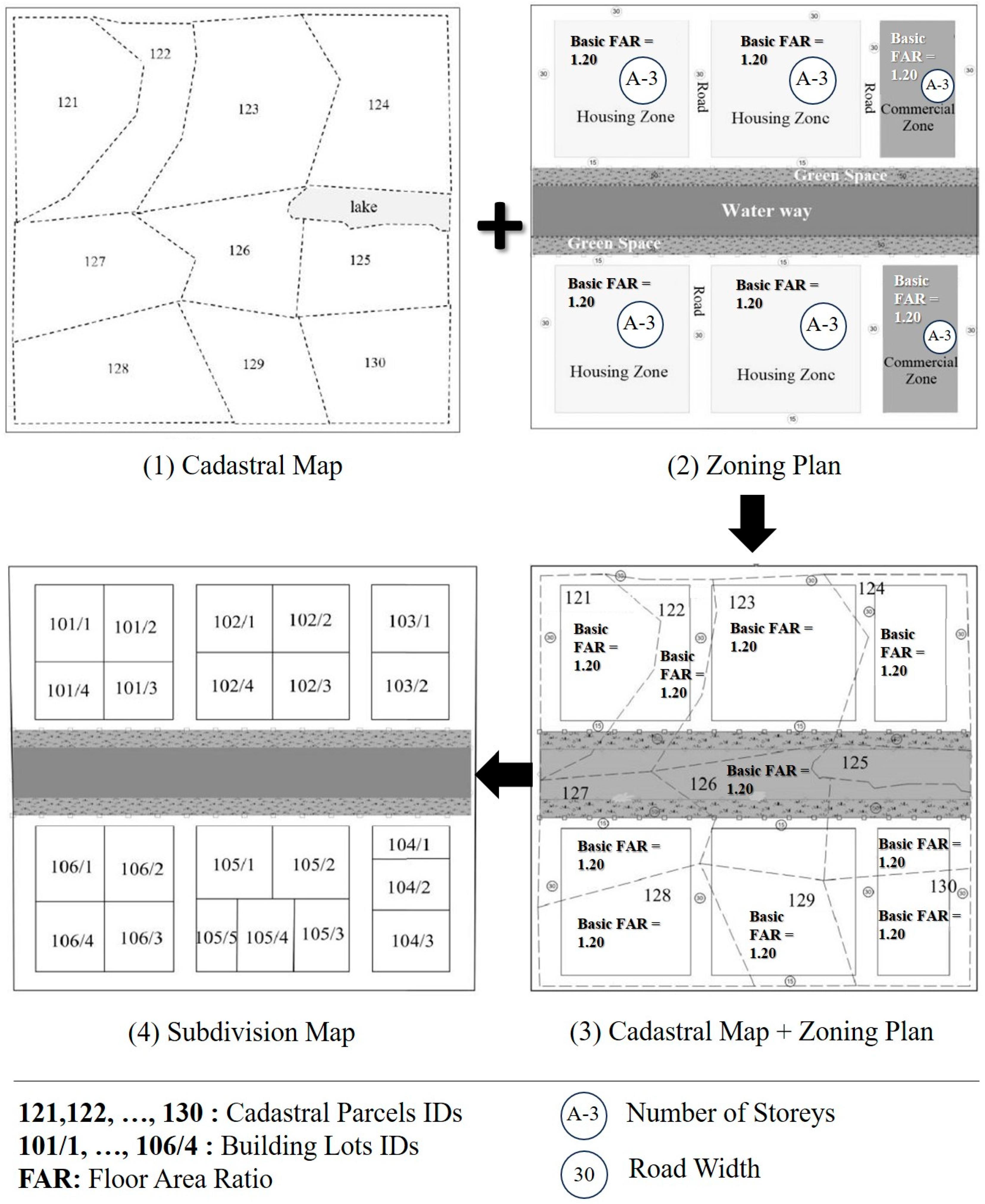
Initially, a 1/1000-scale primary zoning plan is prepared. Development areas for a medium- to high-density population are delineated, centered on the waterway infrastructure. A base FAR of 1.20 is established, and the zoning plan is finalized for implementation (Figure 4(2)).
Unbuildable cadastral parcels are rezoned according to current LR legislation to define new building geometries (see Figure 4). A contribution ratio (CR) is then applied (Equation (1)), with an average CRR of 0.4281405 (42 percent). Parcel deductions, allocations, and the resulting building lots are summarized in Table 3, and the subdivision outcome is illustrated in Figure 4(4).
Under current LR legislation, newly created building lots and all associated development rights defined in the zoning plan remain with the original property owners, who may exercise these rights without providing additional compensation to the municipality. The proposed hLR model, however, implements the following procedures to ensure that increases in land value are captured for public benefit.
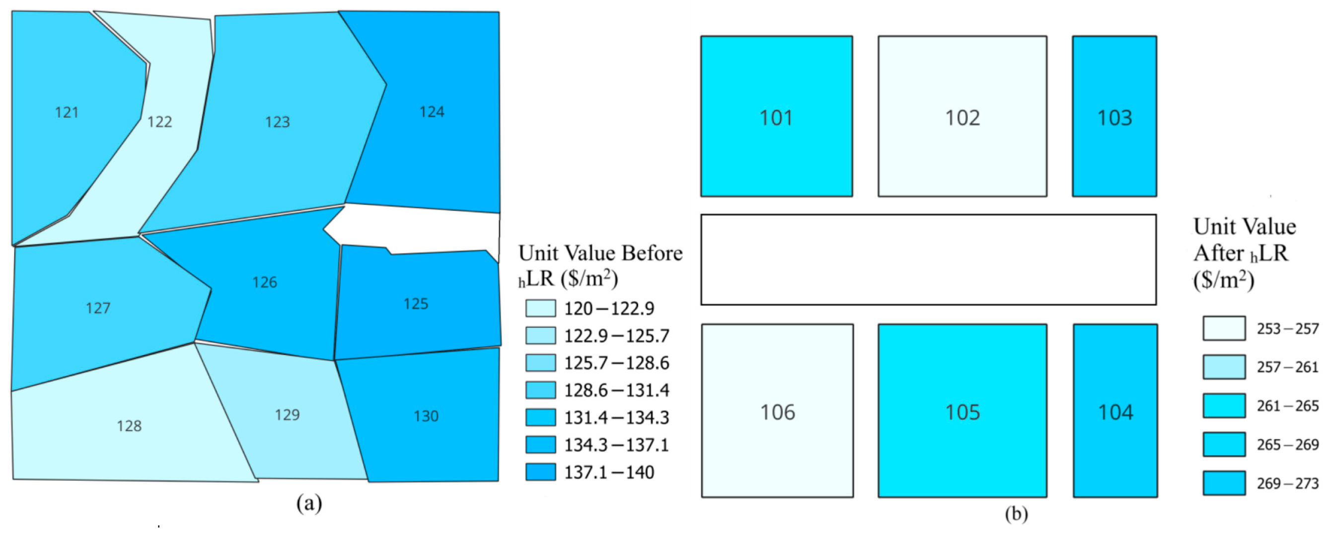
At this stage, a cadastral status value map is produced (Figure 5a). The fair market values of all parcels within the project area are determined using the sales-comparison method and market data recorded prior to the hLR regulation decision date [55,62,63,64]. Comparable properties are selected from within the zoning plan but are not subject to any LR application, and only land values (excluding building improvements) are assessed (see Table 4). Although these values are hypothetical, they are based on 2025 real estate data for Istanbul Province obtained from the Endeksa platform, a digital provider of Turkish market information.
Following the establishment of cadastral parcel values, a building-block value map is produced (Figure 5b). The fair market values of all building blocks within the project area are determined using the sales-comparison method applied to approved subdivision plans [55,62,63,64]. Comparable properties are selected from lots designated in the zoning plan, and their associated development rights are carefully evaluated. Key factors affecting building-lot value include the plan-stipulated development rights, parcel geometry, corner or frontage location, and intended land use [55]. Table 5 presents the unit values per square metre for each building block. Although these values are hypothetical, they are calculated from 2025 Istanbul market data provided by the Endeksa platform.
In the hLR model—based on the transfer of development rights—a new FAR is assigned to each building lot. This assignment draws on three inputs: (1) the market value of the original cadastral parcel, (2) the market value of the corresponding building block, and (3) the basic FAR. Table 6 shows the baseline FAR for each cadastral parcel within the LR area, as determined by the Unplanned Areas Zoning Regulation (see “Section 2.2.1 Preparation Phase of the hLR” for details). Adjusted development rights are calculated using Equation (2) and are also reported in Table 6.
As shown in Table 6, the basic development right (initially defined equally for each cadastral parcel) decreases when parcels are converted into building lots. Consequently, different building blocks receive varying amounts of additional development rights.
Table 7 details the development rights allocated to each individual building lot (from column l of Table 6) as well as the total rights for each block. In the scenario presented, the implementing authority retains discretion to adjust development rights in the detailed zoning plan. Specifically, rights may either remain at the baseline FAR of 1.2 or be increased to 1.6 to support the intended medium-to-high density pattern. For this example, FAR is increased to 1.6.
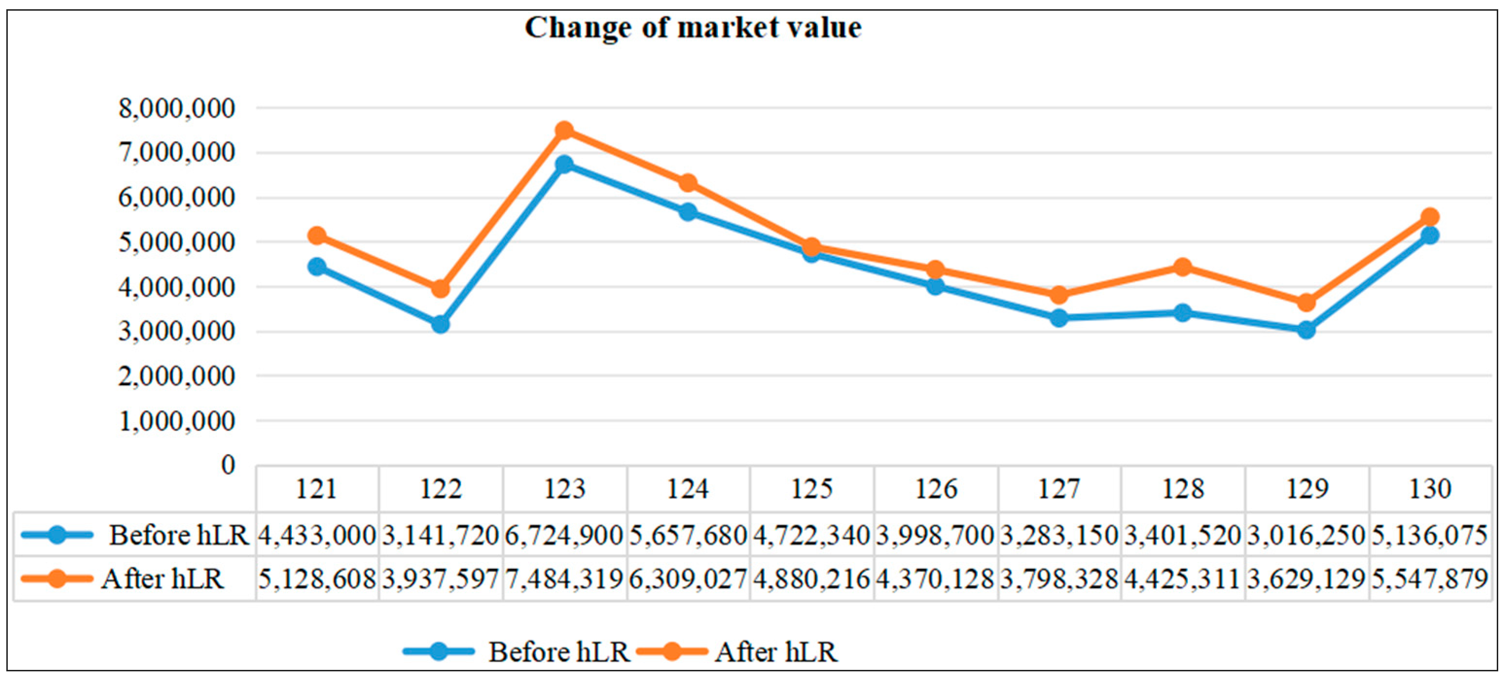
The model indicates an inverse relationship between post-hLR property value appreciation and reductions in development rights. After hLR implementation, parcel values exhibited varied growth. Parcel 128 showed the largest increase of 30 percent (see Table 8 and Table 9) due to its commercial zoning. The average market value increase was 15 percent (Table 9, Figure 6). According to Equation (2), new development rights were reduced on average to 12.5 percent of the basic development right (Table 10). These rights, originally standardized, were adjusted downward in proportion to each building lot’s post-project value (Table 10).

4. Discussion

The need for innovative financing sources for public services has grown over the past decade, and local governments in many countries are increasingly adopting indirect value-capture instruments [71]. Although this study has developed a methodology tailored to the Turkish context, it demonstrates that local solutions can be reconfigured within different institutional and legal frameworks, align closely with the existing international literature, and offer opportunities for shared application in other jurisdictions. For instance:
  • The Swiss regulation requiring the public sharing of 20–50 percent of value increments is adaptable as a fixed-rate redistribution mechanism within the hLR framework [19].
  • The revolving fund mechanism implemented in the Aarhus Ø project in Denmark is compatible with the hLR model by addressing municipal liquidity and pre-financing needs [18].
  • The transplantation of developer obligations from Munich to the Czech Republic has shown that the tradable development rights (TDR) dimension can be adapted to different regulatory systems, thereby providing flexibility to the hLR approach [19].
  • The “net land take” metrics developed by [17] demonstrate the potential alignment of the hLR model with international sustainability targets.
Building on these international experiences, the ways in which similar mechanisms might address Türkiye’s specific institutional challenges will be examined. In Türkiye, difficulties and uncertainties in capturing value through direct taxation, rising costs, and citizens’ growing demand for services have increased the need for innovative financing sources. These challenges have prompted an investigation into Türkiye’s indirect value-capture instruments and the proposal of more innovative approaches. The hLR model has been designed as a land-value-capture scheme based on changes in development rights and land value; its opportunities and challenges are evaluated under the following headings.

4.1. Integration into the Valuation Legislation and the Planning System

Türkiye’s planning system exhibits a persistent disconnect between planning and implementation, resulting in inequalities [72]. Although LR is intended as an LVC tool, it imposes equal deductions on all parcels irrespective of their value, thereby perpetuating inequity. Post-planning variations in FAR further produce unequal gains, and disparities in density and development rights compound these effects [72]. To address these shortcomings, a transition to value-based zoning has been proposed. Despite policy pronouncements in favor of land-value regulation since the 1980s, value-based zoning laws have not yet been enacted [73].
The hLR model also underscores the recommendation to adopt value-based LR. Likewise, the advantages of value-based LR have been empirically and conceptually demonstrated by numerous studies in Türkiye [74,75,76,77,78,79,80,81].
A reliable valuation system is considered vital for value-based approaches [82]. Although valuation before and after regulation may appear straightforward [8], disorganized legislation, limited availability of comparable sales data, subjective appraisals, and the absence of comprehensive price indices hinder the implementation of value-based LR [55,83]. The successful implementation of hLR depends on clearly defined valuation methods, robust data, and transparent procedural rules. Specifically, the definition of valuation dates, valuation methods, criteria for selecting comparables, and standardized guidelines for objective factors enhances transparency and consistency. Although valuation challenges in Türkiye persist, appraisal firms adhering to international standards and employing licensed appraisers [84] may serve as key stakeholders in the hLR process.
The second key distinction of the hLR approach is the adjustment of development rights specified in the zoning plan during the implementation phase. This modification addresses two main challenges. First, disparities in FAR values within the zoning plan can produce unequal economic benefits among property owners, thereby creating inequities [72]. Second, under current practice, development rights assigned to building lots remain exclusively with the original owners. To resolve these issues, the zoning plan and its regulations are designed to allow greater flexibility in the allocation and transfer of development rights.
In Türkiye, planning has traditionally been plan-led—rigidly controlling building specifics such as height, dimensions, floor area, and housing type—unlike the project-led approach common in the Netherlands. Recently, urban transformation projects have adopted a project-led model that increases legal flexibility [85]. This evolution shows that the strict regulations of the local spatial planning system can be relaxed under favourable conditions to serve the public interest. It also enables the introduction of concepts such as basic and additional development rights for public benefit.
Unfettered flexibility is discouraged, as it can lead to ambiguity and erode land value [86]. As [86] notes, “Plans should provide a certain degree of certainty to protect the public interest, but also be flexible enough to ensure that real development needs are met.” The hLR proposal is designed to strike a careful balance between public and private interests.
The hLR proposal does not claim public ownership of all development rights. Under Turkish law, construction rights are granted even in unplanned areas, where building height is limited to three storeys and the footprint ratio is capped at 40 percent. To reflect these constraints—and in line with examples from São Paulo—the hLR model adopts a basic FAR of 1.2. A previous study for Türkiye assumed a construction area of 250 m2 per parcel [64].
hLR requires landowners to contribute to infrastructure provision, in line with existing LR legislation. Under Zoning Law No. 3194, Article 18, a maximum land deduction (contribution rate, CR) of 45 percent is permitted, with the exact rate varying by project. Basic development rights—set at a floor-area ratio (FAR) of 1.20—are fixed and equal for all parcel owners.
Beyond this base entitlement, hLR introduces flexible development rights. These rights may either remain at the baseline FAR of 1.20 or be scaled according to projected population density—such as 1.8, 2.0, or 3.0—within the primary zoning plan. This adaptability is a key strength of the method.
The hLR framework also provides landowners with certainty about future construction capacity and allocates areas for public spaces upon project completion. While the precise allocation of additional development rights is finalized before the end of the implementation phase, flexibility is retained in determining how these rights will finance public infrastructure, underpin ownership transfers, and involve stakeholders. Such flexibility accounts for technical, financial, structural, or legal variations across different project areas.

4.2. Stakeholder Reactions and Participation

Since 1985, LR projects in Türkiye have experienced delays in delivering infrastructure services due to unequal parcel value increases, which have prompted objections and cancellations of zoning plans [73,87]. Although previous research has underscored the importance of public participation [87], low stakeholder involvement and insufficient information have undermined transparency [72,88], increasing the risk of project failure. Comprehensive information for property owners—covering development rights, costs, obligations, and applicable regulations—is therefore essential. The relationship between value increases and development-right allocations must be explained clearly to enhance acceptance of the new LR model.
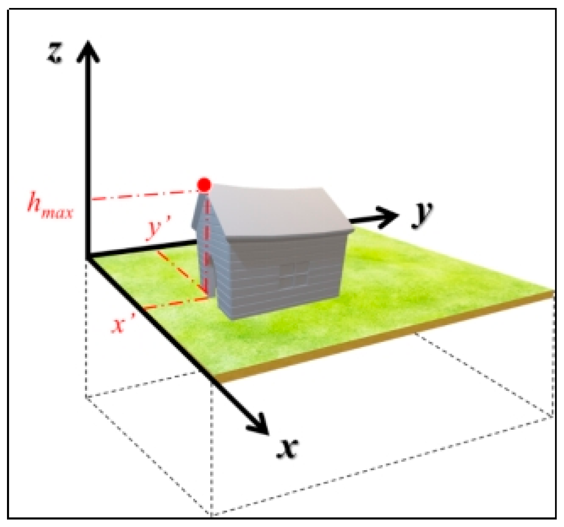
Property owners may object to reductions in basic development rights (see Table 10) that arise when cadastral parcels are reallocated to higher-value building blocks. It should be recognized that property rights consist of two private dimensions and a third, public dimension represented by development rights (see Figure 7) [89]. Limiting development rights in the public interest is lawful, provided that the capture of value increases is conducted in a reasonable and proportionate manner. Such practices must balance public benefit with the owner’s property rights, avoiding excessive burdens on the owner and ensuring equitable outcomes [46]. Legal interpretations and guidance should be provided to support transparency and fairness for all stakeholders.

4.3. Changes in the Property Structure and Restrictions on Property Rights

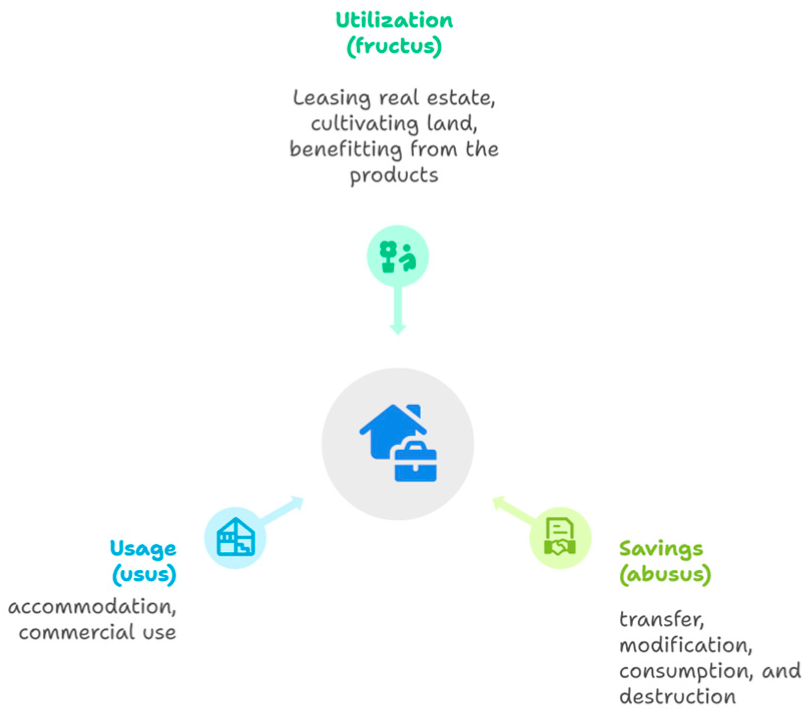
Under the Turkish Constitution, the right to property grants individuals the authority to benefit from, preserve, and utilize their assets (see Figure 8) [90]. However, this right may be limited in the public interest. Although the hLR model has been informed by discussions with municipal practitioners and valuation experts, it has not yet been subjected to a formal, extensive public consultation. We recommend that future pilot implementations include broad stakeholder workshops to refine and tailor the approach.
Regarding the interaction between zoning regulations and property rights, ref. [91] observes that “since the right to property encompasses the right to use one’s property, it must be acknowledged that zoning regulations can impinge upon the right to property.” Accordingly, interventions—such as the allocation of basic, additional, or overriding development rights—must be implemented transparently and for the common good rather than in an arbitrary manner. There is a broad consensus that any increase in land value resulting from public decisions should revert to the public sector. A crucial feature of the proposed hLR model is the independent tradability of development rights in the real estate market, allowing additional rights to be leased, purchased, or sold separately from land ownership.
From a legal perspective, Article 35 of the Constitution of the Republic of Türkiye provides that “Everyone has the right to own and inherit property. These rights may only be limited by law in the interest of the public good.” Zoning plans serve the public interest and may impose restrictions on property rights, provided those restrictions are not excessive. In the hLR context, this principle is applied by defining a basic floor-area ratio (FAR) that limits the vertical dimensions of real property (see Figure 8). In several jurisdictions, zoning rights are recorded on a separate title page in the land registry, distinct from the property title, and treated as independent tradable rights [68,91]. This practice shows that zoning rights can be legally separated from land ownership. As a result, there are no legal barriers to the independent transfer or sale of development rights in Türkiye, although specific regulatory provisions will be required to implement this approach.
Ref. [68] emphasizes the need for independent transfer and sale of development rights under a transfer of development rights (TDR) framework in Türkiye. They argue that this could be achieved by enshrining an easement right in law and the constitution as a standalone entitlement. The proposed hLR model, however, envisions a partnership structure in which ownership is shared among the public sector, an authorized developer, and individual landowners. Under this arrangement, establishing an easement without land sharing—as [68] suggests for TDR—would be inconsistent with the hLR approach. This inconsistency indicates that new legal provisions may be required to reconcile easement rights with the partnership framework of hLR.
Alternatively, the right of superstructure [92], also known as the construction right and provided for in Article 726 of the Turkish Civil Code, can offer a short-term solution to shareholding issues at the end of the project. This right, commonly used in public–private partnership projects, grants the contractor the authority to build and use a structure on the land for a specified period while land ownership remains with the original owner. By doing so, certain rights inherent in property can be transferred independently without conveying or forfeiting the underlying land title [91]. Granting the developer broad powers to transfer the superstructure right to others, bequeath it to heirs, establish condominium ownership, or mortgage it, while the land remains in the owner’s name, is a fair and balanced approach.
In addition to acquiring transferable development rights, basic development rights and land ownership may be obtained through negotiated agreements. Or, the landowner can buy the difference between the development right defined on the building lot and the increased development right. Another approach allows original landowners to receive a separate unit within the new development in exchange for their full property rights, effectively creating a “flats-for-land” arrangement. Various collaboration models are possible. For example, in the New Jersey Canal Crossing Redevelopment project, a real estate holding company was formed by the developer and property owners to manage the development. Shares in the company were allocated to each owner in proportion to their land contribution [93].
Partnership strategies in the proposed hLR model must be voluntary and based on mutual agreement, without undermining property rights. Unlike many urban regeneration schemes, the objective of hLR is not gentrification.

4.4. Cost Recovery

Financing public infrastructure is especially challenging in developing countries such as Türkiye. For example, the Kanal Istanbul project, announced in 2011 with an estimated cost of approximately USD 15 billion, has not been realized because of its financial burden. In this context, value capture mechanisms seek to recoup infrastructure costs from developers by leveraging the value uplift generated by public investments [86]. The hLR model proposes that infrastructure investments be undertaken by public authorities, while developers contribute to project funding through payments to municipalities.
As demonstrated in this study, many urban planning theories advocate the use of land value capture instruments to finance public investments. Numerous analyses of São Paulo’s experience support this approach [36,66,94]. For example, urban regeneration projects in Brazil have successfully generated funding for both initial construction costs and long-term maintenance by implementing zoning by-law amendments and selling CEPAC [95].
Following the scenario outlined in Section 3, once development rights calculated by Equation (2) are allocated to parcels, the remaining unconstrained construction area within each building block equals half of the amount distributed to those parcels. Under the secondary zoning plan, the FAR increases to 1.6. However, the municipality may increase the FAR if required—such as to 1.8, 2.0, or 3.0—based on infrastructure costs and in accordance with urban planning principles. This flexibility is granted to the responsible authority, allowing justified adjustments to the FAR.
The sale of construction area within building blocks to developers enables the public sector to securitise the resulting value increase, potentially generating project funding. Although detailed cost-recovery calculations are beyond the scope of this paper, the proposed hLR system differs from the current abLR model by ensuring that a portion of the value uplift is transferred to the public sector.

5. Conclusions

This study proposes the hLR model as a value-based land value capture (LVC) tool that can be integrated into the planning process. It addresses the inequalities and injustices generated by existing zoning practices and land regulation systems in Türkiye, as well as the shortcomings in financing public infrastructure investments. The model’s primary objective is to ensure the rational and equitable recapture of increased property values arising from public services and actions. It aligns with the public interest by restructuring development rights according to a value-based approach. To demonstrate the core components of the proposed model, a sample hLR implementation scenario was developed. In this scenario, all parcels were initially granted identical basic development rights, corresponding to a floor area ratio of 1.2.
The redistribution of development rights was determined by parcel values before and after hLR and by the values of the building blocks to which those parcels belonged. As a result, parcels within high-value blocks experienced a reduction in their development rights. On average, market values increased by approximately 15 percent, while unit values rose by 100 percent. These findings align with the rise in real property value rates after LR, as reported in [55]. The average reduction in development rights was about 12.5 percent. Because of this inverse relationship, roughly 102,000 m2 of unused construction rights remained in the public domain and became available for public resource transfer. Reducing development rights in response to higher property values is a key strategy for equitable distribution and for public capture of land rent. This balancing was computed using Equation (2), providing a practical basis for cost recovery.
The applicability of the proposed model depends on fulfilling four essential conditions for structural transformation:
(i) Strengthening the institutional and legal framework for real-estate valuation to enable value-based planning;
(ii) Separating development rights from ownership and securitizing those rights;
(iii) Ensuring effective participation from all relevant stakeholders, including property owners, public implementation agencies, developers, planners, surveying and geomatics engineers, and valuation experts;
(iv) Supporting project-based planning processes founded on public–private partnerships, underpinned by legislative flexibility.
The hLR model offers a technical framework for the equitable allocation of development rights within urban planning. It governs property structure and integrates development rights into public financing. In financing public infrastructure investments, it considers the balance among property rights, the public interest, and social justice. As a policy proposal, it promotes fair, transparent, and sustainable urban development in Türkiye. Although its compatibility with abLR provides an advantage, effective integration will require corresponding legal and administrative regulations.
The hLR model, despite necessitating technical expertise in existing planning and valuation systems in Türkiye, remains feasible within the framework of balancing property rights and the public interest. It is a strategic instrument capable of contributing to the transformation of the planning system. To advance its implementation, the model should be evaluated through pilot projects, its legal framework must be reinforced, and it should be embedded in governance structures that emphasize stakeholder participation. The hLR model provides a concrete alternative for restructuring urban infrastructure financing policies at both local and central government levels. Given that financing through value capture is internationally acknowledged as one of the major challenges confronting cities [96], the hLR model aligns directly with the objectives of Sustainable Development Goal 11, which promotes sustainable urban development. Although this study presents a conceptual framework, it lays the groundwork for future empirical research and practical applications.

Author Contributions

Conceptualization, N.C.S. and B.A.A.; Methodology, N.C.S.; Software, S.U.; Validation, N.C.S., B.A.A. and S.U.; Formal Analysis, S.U.; Investigation, B.A.A.; Resources, N.C.S.; Data Curation, N.C.S.; Writing—Original Draft Preparation, N.C.S. and B.A.A.; Writing—Review and Editing, N.C.S., B.A.A. and S.U.; Visualization, N.C.S., B.A.A. and S.U.; Supervision, N.C.S.; Project Administration, N.C.S. All authors have read and agreed to the published version of the manuscript.

Funding

The authors declare that no external funding was received for this study.

Data Availability Statement

Data are contained within the article.

Acknowledgments

The authors would like to thank anonymous reviewers and the editor for their valuable comments and suggestions, which enriched this article.

Conflicts of Interest

The authors declare no conflicts of interest.

Abbreviations

The following abbreviations are used in this manuscript:
CRRContribution Rate Ratio
FARFloor Area Ratio
hLRHybrid Land Readjustment
LVCLand Value Capture

References

  1. Uzun, B.; Celik Simsek, N. Upgrading of illegal settlements in Türkiye; the case of North Ankara Entrance Urban Regeneration Project. Habitat. Int. 2015, 49, 157–164. [Google Scholar] [CrossRef]
  2. Chen, Y.; Jones, C.A.; Dunse, N.A.; Li, E.; Liu, Y. Housing Prices and the Characteristics of Nearby Green Space: Does Landscape Pattern Index Matter? Evidence from Metropolitan Area. Land 2023, 12, 496. [Google Scholar] [CrossRef]
  3. Suzuki, H.; Murakami, J.; Hong, Y.H.; Tamayose, B. Financing Transit-Oriented Development with Land Values: Adapting Land Value Capture in Developing Countries; Urban Development Series; Bank Group: Washington, DC, USA, 2015. [Google Scholar] [CrossRef]
  4. Ercan, E.; Alptekin, E. Increment Value Share as a Kind of Zoning Rent Tax: Determinations and Suggestions in the Light of Current Data. Maliye Derg. 2022, 183, 142–171. [Google Scholar]
  5. Kaya, F. Gayrimenkul Rantlarının Vergilendirilmesi. Vergi Dünyası 2011, 361, 85–92. [Google Scholar]
  6. Hacıköylü, C. Taxation of Income from Selling Property: Changes of New Income Tax Law Draft. Int. J. Public Finance 2016, 1, 194–219. [Google Scholar] [CrossRef]
  7. Türk, S.S. Value capture capacity of area-based land readjustment (lr) in Türkiye. In Proceedings of the XXCI FIG Congress, Istanbul, Turkey, 6–11 May 2018; pp. 6–11. Available online: https://fig.net/resources/proceedings/fig_proceedings/fig2018/ppt/ts11g/TS11G_turk_9306_ppt.pdf (accessed on 20 May 2024).
  8. Uzun, B.; Yıldırım, V.; Çoruhlu, Y.E.; Yıldız, O.; Terzi, F.; Atasoy, B.A. Enhancing Turkish land readjustment via a combination of IPA-based on SWOT and workshops. Land Use Policy 2024, 144, 107245. [Google Scholar] [CrossRef]
  9. Ong, H.C.; Lenard, D. Can private finance be applied in the provision of housing. In Proceedings of the FIG XXII, International Congress, Washington, DC, USA, 19–22 April 2002. [Google Scholar]
  10. Peterson, G.E. Land Leasing and Land Sale as an Infrastructure-Financing Option (English); Policy, Research working paper; no. WPS 4043; World Bank Group: Washington, DC, USA, 2006; Available online: http://documents.worldbank.org/curated/en/133061468142165168/Land-leasing-and-land-sale-as-an-infrastructure-financing-option (accessed on 21 May 2024).
  11. Suzuki, H.; Cervero, R.; Luchi, K. Transforming Cities with Transit: Transitnd Land-Use Integration for Sustainable Urban Development; World Bank: Washington, DC, USA, 2013. [Google Scholar]
  12. Urbanization Council. Comission Reports. 2009. Available online: https://webdosya.csb.gov.tr/db/kentges/editordosya/komisyon_raporlari.pdf (accessed on 5 June 2024).
  13. Alıcı, A.; Battal, Ü. Airport project financing in Türkiye, research on problems and solutions. In Bilimsel Araştırmalar Kitabı-İktisadi ve İdari Bilimler II; Yalçın, A., Ed.; Akademisyen Publishing House: Ankara, Turkey, 2018; Chapter 8. [Google Scholar]
  14. OECD. Global Compendium of Land Value Capture Policies; OECD: Paris, France, 2022. [Google Scholar] [CrossRef]
  15. Peterson, G.E.; Kaganova, O. Integrating Land Financing into Subnational Fiscal Management; Policy Research working paper; no. WPS 5409; World Bank Group: Washington, DC, USA, 2010; Available online: http://documents.worldbank.org/curated/en/173371468149668444/Integrating-land-financing-into-subnational-fiscal-management (accessed on 21 May 2024).
  16. Gracia, N.L.; Young, C.; Lall, S.V.; Vishwanath, T. Leveraging Land to Enable Urban Transformation Lessons from Global Experience; Policy Research Working Paper; no. WPS6312. 2013. Available online: https://documents1.worldbank.org/curated/en/249541468330350173/pdf/wps6312.pdf (accessed on 12 January 2024).
  17. Botticini, F.; Auzins, A.; Lacoere, P.; Lewis, O.; Tiboni, M. Land take and value capture: Towards more efficient land use. Sustainability 2022, 14, 778. [Google Scholar] [CrossRef]
  18. Canelas, P.; Noring, L. Governmentalities of land value capture in urban redevelopment. Land Use Policy 2022, 122, 106396. [Google Scholar] [CrossRef]
  19. Hengstermann, A.; Götze, V. Planning-related land value changes for explaining instruments of compensation and value capture in Switzerland. Land Use Policy 2023, 132, 106826. [Google Scholar] [CrossRef]
  20. Kim, M. Upzoning and value capture: How US local governments use land use regulation power to create and capture value from real estate developments. Land Use Policy 2020, 95, 104624. [Google Scholar] [CrossRef]
  21. Cal, S. Türkiye’de Kamu Hizmeti ve İmtiyazın Dönüşüm Öyküsü; TOBB: Ankara, Turkey; Afşaroğlu Press: Ankara, Turkey, 2008. (In Turkish) [Google Scholar]
  22. Akar, H. Analysıs of Highways Expenditures As Public Infrastructure Investments in the Process of Transition to the Green Economy. Ph.D. Thesis, Public Finance Program, Bursa Uludağ University, Bursa, Turkey, 2021. [Google Scholar]
  23. Irmak, E. An evaluation of using infrastructure investment trusts for financing public investments and infrastructure investments. Master’s Thesis, Business Administration Program, Gazi University, Ankara, Turkey, 2010. [Google Scholar]
  24. SaBD (Strategy and Budget Directorates). PPP Project Indicators. 2023. Available online: https://www.sbb.gov.tr/koi-gostergeleri/ (accessed on 4 April 2024).
  25. Yankaya, U.; Çelik, H.M. İzmir Metrosunun Konut Fiyatları Üzerindeki Etkilerinin Hedonik Fiyat Yöntemi İle Modellenmesi. Dokuz Eylül Üniversitesi İktisadi İdari Bilim. Fakültesi Derg. 2005, 20, 61–79. (In Turkish) [Google Scholar]
  26. Tanrıvermiş, Y.; Keskin, E.; Güneş, P. Analysis About the Effects of Plan Changes In Transportation Systems on Value Increase. Pamukkale Üniversitesi Sos. Bilim. Enstitüsü Derg. 2022, 49, 379–395. [Google Scholar]
  27. Yavuzdurmaz, A.; Karadağ, M. The Main Determinants of The Regional Public Investment Policies in Türkiye. Ege Acad. Rev. 2014, 14, 649–660. [Google Scholar]
  28. Official Gazette. Municipal Revenues Law (in Turkish: Belediye Gelirleri Kanunu). 1981. Available online: https://www.mevzuat.gov.tr/mevzuat?MevzuatNo=2464&MevzuatTur=1&MevzuatTertip=5 (accessed on 11 November 2024).
  29. Polat, S. The Taxation of Public Sourced Real Property Value Increments: A Proposal for Türkiye. Ph.D. Thesis, Karadeniz Teknik Üniversitesi, Trabzon, Turkey, 2021. [Google Scholar]
  30. Smolka, M.O. Implementing Value Capture in Latin America: Policies and Tools for Urban Development; Policy Focus Report; Lincoln Institute of Land Policy: Cambridge, MA, USA, 2013; Available online: https://www.lincolninst.edu/app/uploads/legacy-files/pubfiles/implementing-value-capture-in-latin-america-full_1.pdf (accessed on 29 April 2024).
  31. Ingram, G.K.; Hong, Y.H. (Eds.) Land Value Capture: Types and Outcomes. In Value Capture and Land Policies; English Lincoln Institute of Land Policy: Cambridge, MA, USA, 2012; Available online: https://www.lincolninst.edu/app/uploads/legacy-files/pubfiles/value-capture-and-land-policies-chp.pdf (accessed on 5 June 2024).
  32. Chen, Y.; Chau, K.W.; Yang, L. How the combined use of non-negotiable and negotiable developer obligations affects land value capture: Evidence from market-oriented urban redevelopment in China. Habitat. Int. 2022, 119, 102494. [Google Scholar] [CrossRef]
  33. Akçeşme, H. The Instruments Used in Implementation of Ground Plans and Transfer of the Urban Annuity Cost to the Public-Application of Article 18. Master’s Thesis, Instute of Science and Technology, Gazi University, Ankara, Turkey, 2006. [Google Scholar]
  34. Sanyal, B.; Deuskar, C. A Better Way to Grow? In Value Capture and Land Policies; Town Planning Schemes, Ed.; English Lincoln Institute of Land Policy: Cambridge, MA, USA, 2012; Available online: https://www.lincolninst.edu/publications/conference-papers/town-planning-schemes-hybrid-land-readjustment-process-ahmedabad (accessed on 28 July 2025).
  35. Cervero, R. Rail transit and joint development: Land market impacts in Washington, DC and Atlanta. J. Am. Plan. Assoc. 1994, 60, 83–94. [Google Scholar] [CrossRef]
  36. Nobre, E.A.C. Implementing Land Value Capture in a Global South City: Evaluation of the Experience in the City of São Paulo, Brazil. Rev. Bras. De Estud. Urbanos E Reg 2023, 25, e202327. [Google Scholar] [CrossRef]
  37. Sorensen, A. Land readjustment and metropolitan growth: An examination of suburban land development and urban sprawl in the Tokyo metropolitan area. Prog. Plan. 2000, 53, 217–330. [Google Scholar] [CrossRef]
  38. Fujii, S.; Okata, J.; Sorensen, A. Inner-city redevelopment in Tokyo: Conflicts over urban places, planning governance, and neighborhoods. In Living Cities in Japan; Sorensen, A., Funck, C., Eds.; Routledge: London, UK, 2007; Chapter 12. [Google Scholar]
  39. Mouton, M.; Deraëve, S.; Guelton, S.; Poinsot, P. Negotiated windfalls: Mapping how public actors pursue and share land-value capture in Nanterre-la-Folie, France. Land Use Policy 2023, 131, 106704. [Google Scholar] [CrossRef]
  40. Blanco, A.G.; Moreno, N.; Vetter, D.M.; Vetter, M.F. The Potential of Land Value Capture for Financing Urban Projects: Methodological Considerations and Case Studies; Inter-American Development Bank: Washington, WA, USA, 2016. [Google Scholar] [CrossRef]
  41. Başer, V. Effects of Public Transportation Investments on real property: Ordu-Giresun Airport Example. Karadeniz Fen. Bilim. Derg. 2019, 9, 82–93. [Google Scholar] [CrossRef]
  42. Eryılmaz, Y. Effects of Transportation Infrastructures on Land Value Increase–Tem Highway Istanbul Anatolian Section Example. Ph.D. Thesis, İstanbul Technical University, İstanbul, Turkey, Unpublished work. 2013. [Google Scholar]
  43. Türkoğlu, K. Possibilities that the Planning Implementation Process, which adopts Urban Land Ownership in three dimensions, can bring to the solution of problems. In Kentsel Toprak Mülkiyetini Üç Boyutlu Olarak Benimseyen Planlama Uygulama Sürecinin, Sorunların Çözümüne Getirebileceği Olanaklar; Bayındırlık ve İskan Bakanlığı Publishing: Ankara, Turkey, 1988. (In Turkish) [Google Scholar]
  44. United Nations. The Vancouver Declaration on Human Settlements. United Nations Conference on Human Settlement, Vancouver, Canada. 1976. Available online: https://sdgs.un.org/sites/default/files/documents/7252The_Vancouver_Declaration_1976.pdf (accessed on 15 June 2024).
  45. OECD. OECD Regions and Cities at a Glance 2022. 2022. Available online: https://www.oecd.org/en/publications/oecd-regions-and-cities-at-a-glance-2022_14108660-en.html (accessed on 12 March 2024).
  46. Constitutional Court. Cancellation of the Rule Prescribing the Entire Receipt of the Increased Value as a Result of the Zoning Plan Change. 2023. Available online: https://www.anayasa.gov.tr/tr/haberler/norm-denetimi-basin-duyurulari/imar-plani-degisikligi-sonucunda-artan-degerin-tamaminin-alinacagini-ongoren-kuralin-iptali/ (accessed on 10 August 2024).
  47. Ipek, S.; Engin, R. Place and Significance of Spending Participation Rates in Municipality Incomes: The Case of Çanakkale Province. J. Adm. Sci. 2016, 14, 467–481. [Google Scholar]
  48. Uzun, B.; Atasoy, B.A.; Celik Simsek, N. Unmanned Aerial Vehicle (UAV) support for subdivision phase of land readjustment: A case study from Türkiye. Land Use Policy 2022, 120, 106301. [Google Scholar] [CrossRef]
  49. Doebele, W.A. Conceptual Models of Land Readjustment. In Land Readjustment: The Japanese System; Minerbi, L., Nakamura, P., Nitz, K., Yanai, J., Eds.; A Lincoln Institute of Land Policy Book: Boston, MA, USA, 1986. [Google Scholar]
  50. Yomralıoğlu, T. Arsa ve Arazi Düzenlemesi için Yeni bir Uygulama Şekli; Harita ve Kadastro Mühendisleri Odası Publishing: Ankara, Turkey, 1992; pp. 30–43. (In Turkish) [Google Scholar]
  51. Uzun, B.; Celik Simsek, N. Land readjustment for minimizing public expenditures on school lands: A case study of Türkiye. Arab. J. Geosci. 2018, 11, 228. [Google Scholar] [CrossRef]
  52. Mittal, J. Self-financing land and urban development via land readjustment and value capture. Habitat. Int. 2014, 44, 314–323. [Google Scholar] [CrossRef]
  53. Uzun, B. Using land readjustment method as an effective urban land development tool in Türkiye. Surv. Rev. 2009, 41, 57–70. [Google Scholar] [CrossRef]
  54. Sorensen, A. Land Readjustment, Urban Planning and Urban Sprawl in the Tokyo Metropolitan Area. Urban. Stud. 1999, 36, 2333–2360. [Google Scholar] [CrossRef]
  55. Uzun, B.; Yıldırım, V.; Çoruhlu, Y.E.; Yıldız, O.; Terzi, F.; Atasoy, B.A. The process of transition to a value-based distribution model in the Turkish land readjustment system. Land Use Policy 2024, 147, 107360. [Google Scholar] [CrossRef]
  56. Yomralıoğlu, T.; Tüdeş, T.; Uzun, B.; Eren, E. Land Readjustment Implementations in Türkiy. In Proceedings of the XXIVth International Housing Congress, Ankara, Turkey, 27–31 May 1996; pp. 150–161. [Google Scholar]
  57. Doebele, W.A. Land Readjustment: A Different Approach to Financing Urbanization; Lexington Books: Lexington, MA, USA, 1982. [Google Scholar]
  58. Kitay, M.G. Land Acquisition in Developing Countries; Lincoln Institute: Boston, MA, USA, 1985. [Google Scholar]
  59. Uzun, B. To Investigate highway-property relations in respect of zoning rights and to propose a mode using land readjustment approach. Ph. D. Thesis, Natural and Applied Sciences Geomatic Graduate Program, Karadeniz Technical University, Trabzon, Turkey, 2000. [Google Scholar]
  60. Yilmaz, A.; Çağdaş, V.; Demir, H. An evaluation framework for land readjustment practices. Land Use Policy 2015, 44, 153–168. [Google Scholar] [CrossRef]
  61. Köktürk, E.; Köktürk, E. Yeni Bir İmar Tüzesinin ve En Önemli Öğesi Olarak Arsa Düzenlemelerinde Eşdeğerlik İlkesinin Oluşturulması. 2005. Available online: https://obs.hkmo.org.tr/show-media/resimler/ekler/SY62_105_ek.pdf (accessed on 18 May 2025).
  62. Köktürk, E.; Köktürk, E. Arsa Düzenlemesinde Eşdeğerlik İlkesinin Modellenmesi. 2007. Available online: https://www.hkmo.org.tr/resimler/ekler/9ZMU_dbb3fb9a5cd1d5f_ek.doc (accessed on 18 May 2025).
  63. Köktürk, E.; Köktürk, E. Real property Valuation in Land Subdivision Based on Equivalency Principle. Jeodezi Jeoinformasyon Ve Arazi Yönetimi Derg. 2009, 2, 101. [Google Scholar]
  64. Çağdaş, V. A Development Right-Based Land Readjustment Model. Harit. Derg. 2019, 161, 57–66. [Google Scholar]
  65. Selçuk, İ.A. Population Subject in Urban Planning and Mathematical Methods Using for The Forecast of Them. Artium 2014, 2, 191–206. [Google Scholar]
  66. Sandroni, P.H. Recent Experience with Land Value Capture in São Paulo, Brazil. Linc. Inst. Land Policy Land Lines 2011, 23, 14–19. Available online: https://www.lincolninst.edu/publications/articles/recent-experience-land-value-capture-sao-paulo-brazil/ (accessed on 18 June 2024).
  67. Sánchez, F.; Broudehoux, A.M. Mega-events and urban regeneration in Rio de Janeiro: Planning in a state of emergency. Int. J. Urban Sustain. Dev. 2013, 5, 132–153. [Google Scholar] [CrossRef]
  68. Kocalar, A.C.; Eryoldaş, A. Koruma Amaçlı İmar Planı Uygulanan Taşınmazlarda Sınırlandırılan Mülkiyet ve İmar Haklarının Değerlendirilerek Aktarımı. Tasarım Ve Kuram 2010, 9, 71–81. [Google Scholar]
  69. Şengezer, B.; Evren, Y.; Ökten, A.N.; Kozaman Som, S. Who Gets ‘What’ in Cities? Questioning İstanbul’s Skyscrapers. Megaron 2009, 4, 71–78. [Google Scholar]
  70. Nelson, A.C.; Pruetz, R.; Woodruff, D. The Tdr Handbook: Designing and Implementing Transfer of Development Rights Programs; Island Press: Washington, WA, USA, 2012; p. 344. [Google Scholar]
  71. Alterman, R. Land use regulations and property values: The "Windfalls Capture” Idea Revisited. In The Oxford Handbook on Urban Economics and Planning; Brooks, N., Donanghy, K., Knapp, G.J., Eds.; Oxford Uni. Press: Oxford, UK, 2012; Chapter 33. [Google Scholar]
  72. Erdem, F.; Meshur, M.C. Problems of land readjustment process in Türkiye. Sci. Res. Essay 2009, 4, 720–727. [Google Scholar]
  73. Aliefendioglu, Y.; Bazame, R.; Uisso, A.; Tanrivermis, H. Current Practices and Issues of Land Readjustment in Türkiye and the Requirements for Value-based Approach Adoption. In Proceedings of the 26th Annual European Real Property Society Conference, Cergy-Pontoise, France, 3–6 July 2019. [Google Scholar] [CrossRef]
  74. Uzun, B.; Yomralıoglu, T. An Alternative Approach to Land Compensation Process to Open Urban Arteries. In Proceedings of the FIG Working Week 2005 and GSDI-8, Cairo, Egypt, 16–21 April 2005. [Google Scholar]
  75. Urbanization Council, 2017. (9 November 2017, Ankara). Available online: https://webdosya.csb.gov.tr/db/sehirciliksurasi/icerikler/n-ha--sonuc-b-ld-rges--20180226120835.pdf (accessed on 28 July 2025).
  76. Yıldız, N. Arsa ve Arazi Düzenlemesinde Es degerlilik ve Esitlik Ilkelerinin Karsılastırılması. In Proceedings of the Türkiye 1. Bilimsel ve Teknik Kurultayı, Ankara, Turkey, 23–27 February 1987. [Google Scholar]
  77. Ulger, E.; Yıldız, N.; Baz, I.; Ülger, B.C.; Yürekdurmaz, F. Alan Düzenleme Ana Uygulama Esaslarını Belirleme Projesi; Bayındırlık ve Iskan Bakanlıgı, Teknik Arastırma ve Uygulama Genel Müdürlügü: Ankara, Turkey, 2006. [Google Scholar]
  78. Yıldız, F.; Ozkan, G.; Yalpır, S. Alan düzenleme ana uygulama esaslarının belirlenmesinde deger esitligini esas alan modellerin uygulaması üzerine bir arastırma. HKMO Jeodezi Jeoinformasyon Ve Arazi Yonet. Derg. 2008, 99, 5–14. [Google Scholar]
  79. Yomralıoglu, T.; Nisancı, R.; Yıldırım, V. An Implementation of Nominal Asset Based Land Readjustment. In Proceedings of the Strategic Integration of Surveying Services, FIG Working Week 2007, Hong Kong SAR, China, 13–17 May 2007. [Google Scholar]
  80. Yılmaz, A. Imar Uygulaması Degerleme çatkısının Olusturulması ve Deger Esaslı Uygulama Modelinin Ülkemize Uyarlanması. Ph.D. Thesis, Yıldız Teknik Üniversitesi, Istanbul, Turkey, 2016. [Google Scholar]
  81. Yalpır, S.; Ekiz, M. Esdegerlik esaslı arazi ve arsa düzenlemesinde analitik hiyerarsi prosesin kullanımı. OHÜ Müh. Bilim. Derg. 2017, 6, 59–75. [Google Scholar] [CrossRef]
  82. Çağdaş, V.; Linke, H.-J. An institutional analysis of land readjustment in Türkiye. Surv. Rev. 2021, 53, 252–262. [Google Scholar] [CrossRef]
  83. Erdem, N. Investigation of the Effectiveness of Türkiye real property Valuation System. J. Geomat. 2019, 4, 1–13. [Google Scholar] [CrossRef]
  84. Coskun, Y. The Establishment of the real property Regulation and Supervision Agency of Türkiye (RERSAT). Hous. Financ. Int. 2011, 25, 42–51. Available online: https://ssrn.com/abstract=1874648 (accessed on 28 July 2025).
  85. Tarakci, S.; Turk, S.S. Flexibility in Urban Renewal Practices: The Case of Türkiye. In Proceedings of the Book of Proceedings: Annual AESOP Congress, Spaces of Dialog for Places of Dignity, Lisbon, Portugal, 11–14 July 2017. [Google Scholar]
  86. Gielen, D.M.; Tasan-Kok, T. Flexibility in Planning and the Consequences for Public-value Capturing in UK, Spain and the Netherlands. Eur. Plan. Stud. 2010, 18, 1097–1131. [Google Scholar] [CrossRef]
  87. Hong, Y.H. Assembling Land for Urban Development: Issues and Opportunities. In Analyzing Land Readjustment Economics, Law, and Collective Action; Hong, Y.H., Needham, B., Eds.; Lincoln Inst of Land Policy: Cambridge, MA, USA, 2007; Chapter 1. [Google Scholar]
  88. Akdeniz, H. Land Readjustment as an Implementation Tool for Urban Plans. J. Urban. Stud. 2022, 37, 1753–1771. [Google Scholar] [CrossRef]
  89. Keleş, R.; Geray, C.; Emre, C.; Mengi, A. Bringing urban land rent into public use. In Kentsel Toprak Rantının Kamuya Kazandirilmasi; Türkiye Kent Kooperatifleri Merkez Birliği Publishing House: Ankara, Turkey, 1999. (In Turkish) [Google Scholar]
  90. Celik Simsek, N. Three-Dimensional Model Based Approach in The Management of Real Properties Subjected to Condominium Ownership. Ph.D. Thesis, Natural and Applied Sciences Geomatic Graduate Program, Karadeniz Technical University, Trabzon, Turkey, 2019. [Google Scholar]
  91. Aynural, M.S. Legal Regime of Transfer of Development Rights. Master’s Thesis, Institute of Social Sciences, Istanbul University, Istanbul, Turkey, 2020. [Google Scholar]
  92. Hansu, E. Kamu Özel İşbirliği Kapsamında Üst Hakkı; Seçkin Yayıncılık: Ankara, Turkey, 2022. [Google Scholar]
  93. BRS (Brownfields Redevelopment Solutions). A Framework for Land Readjustment and Equitable Redevelopment at the Canal Crossing Redevelopment Area and Case Study; Brownfields Redevelopment Solutions: Medford, NJ, USA, 2014. [Google Scholar]
  94. Silvestre, G. Replicated or homegrown planning model? The mutual constitution of ideas, interests and institutions in the delivery of a megaproject in Rio de Janeiro. Int. Plan. Stud. 2022, 27, 107–119. [Google Scholar] [CrossRef]
  95. Biderman, C.; Sandroni, P.; Smolka, M. The Case of Faria Lima in São Paulo. Land Lines 2006, 18, 8–13. Available online: https://www.lincolninst.edu/publications/articles/large-scale-urban-interventions (accessed on 28 July 2025).
  96. Souza, F.F.D.; Ochi, T.; Hosono, A. Land Readjustment: Solving Urban Problems Through Innovative Approach, 1st ed.; Japan International Cooperation Agency Research Institute: Tokyo, Japan, 2018. [Google Scholar]
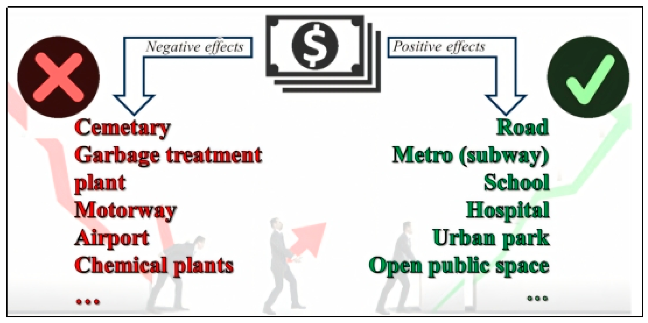
Figure 1. Public investments’ impact on real property value.
Land 14 01570 g001
Figure 2. Primary zoning plan and distribution of basic development rights to cadastral parcels.
Land 14 01570 g002
Figure 3. Conceptual schema of the hLR model.
Land 14 01570 g003
Figure 4. Recommended hLR mechanism.
Land 14 01570 g004
Figure 5. (a) The cadastral status value map; (b) the building block value map.
Land 14 01570 g005
Figure 6. Change in market value of cadastral parcels.
Land 14 01570 g006
Figure 7. The three dimensions of property rights.
Land 14 01570 g007
Figure 8. Bundle of powers arising from property rights (adapted from [90]).
Land 14 01570 g008
Table 1. Different LVC instruments and their intended use.
Country
(City)
LVC InstrumentsPurpose of UseSource
ChinaLand leasingFinancing of urban infrastructure[10]
IndiaLand leasingConstruction of bridge and metro rail systems[10,15]
Transfer of land to the stateInfrastructure and social housing construction[34]
Betterment levyHalf of infrastructure cost paid by property owners[34]
USA
(Washington)
Joint developmentCovering part of the annual income of the transport authority[35]
Brazil
(São Paulo)
Certificates of Additional Construction Potential (CEPAC)Urban infrastructure investments[36]
Japan
(Tokyo)
Land readjustmentUsing some reserve areas for public use and selling others to fund public infrastructure[37]
Urban redevelopment schemeCovering consolidation and public facility costs by selling additional development rights[38]
Table 2. The current status of the hLR area and its possible post-plan status.
AttributeCurrent StatusPost-Plan Status
Management UnitWithin the boundaries of the municipalityWithin the boundaries of the municipality
Zoning PlanNone1/1000-scale zoning plan
Current LegislationUnplanned Areas Zoning RegulationZoning Law No. 3194 with new hLR-related articles
Area Size330 ha330 ha
Ownership StatusPrivate and public ownershipPrivate and public ownership
Land UseCultivated/Planted area; Vacant land; Natural areaResidential; Commercial and mixed use; Green space and recreation; Roads and transportation; Waterway (Canal)
Planning PrinciplesNoneCanal-oriented urban design; Mixed-use principle (residential, commercial, open spaces); Areas reserved for public service
Population Density (gross)Very low Medium (approximately 250 persons/ha)
Development RightsUp to 3 storeys; FAR ≤ 1.2Flexible according to plan decisions; Minimum FAR = 1.2
Owner of Development RightsProperty ownersProperty owners and competent authority (municipality)
Table 3. Area calculations in summary chart.
Cadastral Parcel IDParcel Area (m2)—
[a]
Contribution Area (m2)—[b]
[b] = [a] × CRR
Allocated Area (m2) [c]
[c] = [a] − [b]
Building Lot IDs
12134,100.0014,599.59 19,500.41101/1, 101/2
12226,181.0011,209.15 14,971.85101/3, 101/4, 102/4
12351,730.0022,147.71 29,582.29 102/1, 102/2, 102/3
12440,412.0017,302.01 23,109.99 103/1, 103/2, 104/1
12533,731.0014,441.61 19,289.39 104/1, 106/1, 106/2
12629,620.0012,681.52 16,938.48 102/4, 105/1
12725,255.0010,812.69 14,442.31 105/2
12828,346.0012,136.07 16,209.93 104/2, 104/3
12924,130.0010,331.03 13,798.97 105/3, 105/4
13038,045.0016,288.61 21,756.39 105/5, 106/3, 106/4
Total331,550.00141,950.00 189,600.00
Table 4. Unit values of cadastral parcels before hLR (USD/m2).
Parcel ID121122123124125126127128129130
Unit Value (USD/m2)130120130140140135130120125135
Table 5. Unit values of building blocks after hLR (USD/m2).
Block ID101102103104105106Total
FunctionHousing Housing CommercialCommercialHousingHousing
Area (m2)34,20038,00019,00020,50041,00036,900189,600
Unit Value (USD/m2)263253273273263253
Table 6. Development-right transformation.
Before the hLRAfter the hLR
Parcel IDParcel Area (m2)Parcel Market Value (USD) (Area × Unit Value)
—[g]
Building Lot IDLot Area (m2)
—[h]
Unit Value (USD/m2)
—[i]
Lot Market Value (USD) (Area × Unit Value)
—[j]
New FAR—[k]
[k] =
([g] × BDR])/[j]
Total Build Area (m2)—[l]
[l] = [k] × [h]
12134,100.002,216,500101/1 9750.002632,564,3581.0410,140.00
2,216,500101/29750.002632,564,2501.0410,140.00
Total (121)4,433,000-19,500.00-5,128,608-20,280.00
12226,181.001,542,425101/37350.002631,933,2740.967,056.00
1,542,425101/4 7350.002631,933,0500.967,056.00
56,870102/4271.0025368,5631.00271.00
Total (122)3,141,720-14,971.00-3,934,887-14 383.00
12351,730.002,159,643102/19500.002532,403,5731.0810,260.00
2,159,643102/2 9500.002532,403,5001.0810,260.00
2,405,615102/310,582.002532,677,2461.0811,428.56
Total (123)6,724,900-29,582.00-7,484,319-31,948.56
12440,412.002,325,745103/19500.002732,593,7701.0810,260.00
2,325,745103/2 9500.002732,593,5001.0810,260.00
1,006,191104/14110.002731,122,0301.084438.80
Total (124)5,657,680-23,110.00-6,309,300-24,958.80
12533,731.0044,070104/1180.0027349,2461.07192.60
2,339,135106/1 9554.002532,417,1621.1611,082.64
2,339,135106/29554.002532,417,1621.1611,082.64
Total (125)4,722,340-19,288.00-4,883,570-22,357.88
12629,620.001,923,333102/48147.002532,061,3121.129124.64
2,075,367105/18791.002632,312,0331.089494.28
Total (126)3,998,700-16,938.00-4,373,345-18,618.92
12725,255.003,283,150105/214,442.002633,798,3281.0415,019.68
12828,346.001,700,760104/28105.002732,212,9190.927456.6
1,700,760104/38105.002732,212,6650.927456.6
Total (128)3,401,520-16,210.00-4,425,584-14,913.2
12924,130.001,508,125105/3 6899.002631,814,6921.006899.00
1,508,125105/46899.002631,814,4371.006899.00
Total (129)3,016,250-13,798.00-3,629,129-13,798.00
13038,045.00937,030105/53969.002631,043,9501.084286.52
2,099,523106/3 8893.002532,249,9291.129960.16
2,099,523106/48893.002532,249,9291.129960.16
Total (130)5,136,075-21,755.00-5,543,808-24,206.84
TOTAL43,515,335-189,600.00-49,510,878-200,484.88
Table 7. Distribution of total buildable area under FAR 1.6: area allocated to individual lots vs. area retained by the authority.
Block IDBlock Area (m2)—(m)Total Build Area (FAR = 1.6)—(n)
(n) = FAR × (m)
Area Allocated to Lots (m2)—(o)Area Retained by Authority (m2)—(p)
(p) = (n) − (o)
10134,200.00 54,720.0034,392.0020,328.00
10238,000.00 60,800.0041,344.2019,455.80
10319,000.00 30,400.0020,520.009880.00
10420,500.00 32,800.0019,544.6013,255.40
10541,000.00 65,600.0042,598.4823,001.52
10636,900.00 59,040.0042,085.6016,954.40
Total189,600.00303,360.00200,484.88102,875.12
Table 8. Change in market value of cadastral parcels before and after hLR.
Before hLRAfter hLR
Cadastral
Parcel ID
Pre-hLR Area (m2)—(t)Pre-hLR Unit Value (USD/m2)—(q)Pre-hLR Market Value (USD)
(u) = (t) × (q)
Post-hLR Lot Area (m2)—(v)Post-hLR Unit Value (USD/m2)—(r)Post-hLR Market Value (USD)
(w) = (v) × (r)
12134,100.001304,433,00019,500.00 263 5,128,608
12226,181.001203,141,72014,972.00 2633,937,597
12351,730.001306,724,90029,582.00 253 7,484,319
12440,412.001405,657,68023,110.00273 6,309,027
12533,731.001404,722,34019,289.00 253 4,880,216
12629,620.001353,998,70016,938.00 258 4,370,128
12725,255.001303,283,15014,442.00 263 3,798,328
12828,346.001203,401,52016,210.00 2734,425311
12924,130.001253,016,25013,799.00 263 3,629,129
13038,045.001355,136,07521,756.00 2555,547,879
Total331,550.00 43,515,335189,600.00 49,510,542
Table 9. Unit-value and market-value increases in cadastral parcels.
Cadastral Parcel ID121122123124125126127128129130
Unit valueCoefficient
(s) = (r)/(q)
2.02 2.19 1.941.95 1.801.91 2.022.282.101.88
Increase (%)
(t) = [[(r) − (q)]/(q)] × 100
102.3119.094.6295.0080.7191.25102.3127.50110.4088.76
Market valueCoefficient
(x) = (w)/(u)
1.161.251.111.121.031.091.161.301.201.08
Increase (%)
(y) = [[(w) − (u)]/(u)] × 100
15.6925.3311.2911.513.349.2915.6930.1020.328.02
Table 10. Change in development rights of cadastral parcels.
Parcel ID121122123124125126127128129130
Pre-hLR FAR1.201.201.201.201.201.201.201.201.201.20
Post-hLR FAR1.040.961.081.081.161.11.040.921.001.11
FAR Coefficient (Post/Pre)0.870.800.900.900.960.920.860.760.830.92
FAR Decrease (%)13.32010103.38.313.323.316.77.5
Disclaimer/Publisher’s Note: The statements, opinions and data contained in all publications are solely those of the individual author(s) and contributor(s) and not of MDPI and/or the editor(s). MDPI and/or the editor(s) disclaim responsibility for any injury to people or property resulting from any ideas, methods, instructions or products referred to in the content.