Abstract
The construction and maintenance of an ecological security pattern (ESP) are important for promoting the regional development of ecological civilizations, realizing sustainable and healthy development, and creating a harmonious and beautiful space for human beings and nature to thrive. Traditional construction methods have the limitations of a single dimension, a single method, and excessive human subjective intervention for source and corridor identification, without considering the multidimensional quality of the sources and the structural connectivity and resilience optimization of the corridors. Therefore, an ecological civilization demonstration area (Jiangxi Province) was used as the study area, a new research method for ESP was proposed, and an empirical study was conducted. To evaluate ecosystem service (ES) importance–disturbance–risk and extract sustainability sources through the deep embedded clustering–self-organizing map (DEC–SOM) deep unsupervised learning clustering algorithm, ecological networks (ENs) were constructed by applying the minimum cumulative resistance (MCR) gravity model and circuit theory. The ENs were then optimized to improve performance by combining the comparative advantages of the two approaches in terms of structural connectivity and resilience. A comparative analysis of EN performance was constructed among different functional control zones, and the ESP was constructed to include 42 ecological sources, 134 corridors, 210 restoration nodes, and 280 protection nodes. An ESP of ‘1 nucleus, 3 belts, 6 zones, and multiple corridors’ was constructed, and the key restoration components and protection functions were clarified. This study offers a valuable reference for ecological management, protection, and restoration and provides insights into the promotion of harmonious symbiosis between human beings and nature and sustainable regional development.
1. Introduction
According to an intergovernmental panel on climate change (IPCC) report, the average temperature worldwide has increased by approximately 1.1 °C since the industrialization era; however, the rate of warming has accelerated. Climate change and man-made disturbances have imposed major challenges for the global ecological environment and human social development [1], and the sustainability of cities and societies has become a key issue [2]. With the advancement in urbanization, disorderly urban expansion and large-scale reductions in ecological land have undermined the connectivity and stability of ecosystems, posing a tremendous threat to regional social development and sustainability and to ecological health and security [3,4]. Ecological security refers to a state of ecological balance and health and involves the basic resources and environmental components necessary for human survival. The ecological security pattern (ESP) is an important component of the territorial spatial development pattern. The construction and maintenance of an ESP is conducive to enhancing the stability of the ecosystem, strengthening the protection of biodiversity, and increasing the ability and efficiency in the provision of ecosystem services (ESs), which are important for promoting the regional development of ecological civilizations [5], realizing sustainable and healthy development, and creating a harmonious and beautiful space for human beings and nature to thrive. Therefore, determining how to scientifically and reasonably construct ESPs has become a topic of widespread concern and a crucial issue that must be urgently resolved in the context of the construction of an ecological civilization.
In recent years, ESP researchers have introduced the theory of ‘patch–corridor–substrate’ [6], and most of them have adopted the ‘source–resistance–corridor’ paradigm [7]. Sources, resistance, and corridors, as key elements of the ESP, have been explored and studied by scholars from different perspectives. Three methods are used to recognize ecological source areas; one way is to use nature reserves, important ecological zones, ecologically protected red line areas, scenic spots, and related resources as ecological sources directly [8]. This method is comparatively simplistic and convenient, but consideration of overall ecological quality is lacking, and it is easily affected by relevant policies. The second is to identify core areas via morphological spatial pattern analysis (MSPA) and then define these areas as source areas [9,10]. This approach accounts for landscape connectivity but does not fully consider the quality and health of ecosystems. The third method involves evaluating the importance of ESs [11,12,13], ecological sensitivity [13,14], ecological quality [13,15], and related factors, and areas that have high evaluation ratings are defined as source areas. This approach accounts for the spatial heterogeneity of ecological patches, thus making the selection of sources scientific and rational. In the extraction process, the number and size of sources are usually determined by either directly setting a minimum area [11] or by selecting a certain percentage of sources ranked from largest to smallest. When the area and ratio are set, they are easily influenced by subjective human factors, resulting in failure to extract the ecological source area accurately.
The process of establishing resistance surfaces commonly accounts for the disparities in the influences of various land use types on ecological resistance, and the corresponding resistance values are set separately [16]. However, this approach does not differentiate the variations in ecological resistance within zones of an identical type of land use and regardless of disturbances linked to human and social activities.
In corridor extraction, methods that have been widely adopted by many scholars in the field include the circuit theory [17,18] and the minimum cumulative resistance (MCR) [13,19,20] methods. In the MCR approach, the cumulative resistance that biological species face when they move between ecological source regions and target locations is calculated. In general, the path with the lowest level of resistance is chosen as the optimal route for biological migration, species exchange, and energy diffusion, overlooking the randomness of species choices in real-world scenarios [21]. Circuit theory places more emphasis on stochasticity, combining simulated flows of biological species with random states of electrons traveling through resistors, with a theoretical approach used to identify the corresponding corridor widths [22]; therefore, this method is favored by numerous scholars. However, the structural connectivity and ecological resilience of ecological networks (ENs) cannot be captured through the above methods alone.
The above studies provide good ideas and inspiration for ESPs, but several limitations and shortcomings remain. (1) The choice of ecological sources depends on simple and single-quality dimensions without a comprehensive consideration of multidimensional quality and landscape connectivity, thresholds for the delineation of integrated stacking, and evaluation levels, and the number of sources extracted is easily influenced by subjective factors. (2) The construction of resistance surfaces does not differentiate the variations in ecological resistance within zones of an identical type of land use or from disturbances linked to human and social activities. (3) The corridor extraction process focuses only on the minimum path or randomness, without considering the structural connectivity and resilience of the network.
As one of the first national ecological civilization demonstration areas, Jiangxi Province undertakes the task of early and pilot implementation of ecological civilization construction, and at the same time, as a critical ecological barrier in the middle and lower reaches of the Yangtze River, the construction of an ESP is highly important for maintaining regional and national security. There are many national nature reserves, forest parks, geological parks, and scenic spots in the area, and the landscape is rich in ecological resources. As urbanization has accelerated, ecological problems such as the destruction of ecosystems and dramatic increases in ecological protection pressure have become increasingly prominent. Currently, scholars have studied contributing factors such as ecosystem service bundles [23], ES drivers [24], trade-offs and synergies [25,26], and ES values [27]. Therefore, the study of ESPs with Jiangxi Province as a region is crucial for guaranteeing ecological security and improving the regional ecological management system, which can offer scientific foundations and technological assistance for the construction of an ecological civilization.
In summary, the aims of this research are as follows: (1) perform a comprehensive analysis of ES importance–disturbance–risk, extract sustainability sources through the deep embedded clustering–self-organizing map (DEC–SOM) deep unsupervised learning clustering algorithm, and apply the MSPA and landscape connectivity index to determine the ecological source area; (2) incorporate disturbances linked to human and social activities into ecological resistance and improve the system of resistance surfaces through the participation of experts in the field of ecology; (3) construct ENs by applying the MCR gravity model and circuit theory and then optimize them based on a comparative analysis of structural connectivity and resilience; (4) conduct a comparative analysis of EN performance among different functional control zones; and (5) construct an ESP by combining each key ecological element. In this study, relevant methods and theories in the ecological field are integrated, and a new research framework for ESPs is proposed, providing a reference for other regional studies. The framework supports a comprehensive understanding of key ecological elements, offers a valuable reference for ecological management, protection, and restoration, and provides vital guidance for preserving the health and sustainable development of ecosystems.
2. Materials and Methods
2.1. Study Area
Jiangxi Province is in the southeastern region of central China and is abbreviated as ‘Gan’; it encompasses 11 cities, of which Nanchang is the capital city. The area has a subtropical monsoon climate, and the average temperature throughout the year varies from 16.3 to 25 °C. It lies in the hilly zone of Jiangnan, China, with mainly mountainous terrain. The overall elevation is high in the south and low in the north, with a high perimeter and low center, rolling hills and rivers, and a dense river network, with a forest coverage rate of 63.1%, which is the second highest in China. The province has an area of 166.9 thousand km2. Its location is shown in Figure 1.
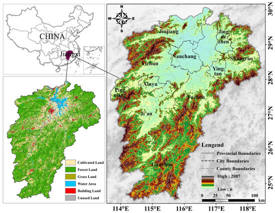
Figure 1.
Position of the research region.
2.2. Data Sources
The data include natural geographic, climate, soil, social, economic, and other data. First, the data were classified, organized, extracted and vectorized using ArcGIS 10.8 software; then, they were projected to the WGS 1984 spatial coordinate system. Table 1 illustrates the situation.

Table 1.
Data sources.
2.3. Methods
This study explored and improved the basic paradigm of ecological corridor construction by effectively integrating and utilizing theories and modeling methods in ecologically related fields. We subsequently proposed a new research framework. First, the importance, disturbance, and risk of ESs were quantified, combined with the distribution of the ecological protection red line, and the DEC–SOM unsupervised deep learning algorithm was used to identify potential ecological sources; second, the ecological source areas and buffer zones were again identified in conjunction with the MSPA and landscape connectivity index; third, a hierarchical analysis was conducted to construct a system of resistance surfaces through the participation of experts in the ecological field; fourth, ENs were constructed by applying the MCR gravity model and circuit theory; and, finally, we compared the structural connectivity and resilience of the two networks. Important corridors in the latter network were screened and optimized based on those in the former network. The ecological protection nodes and restoration nodes were identified, and the performance of ENs in different functional control zones was analyzed. Finally, an ESP consisting of ‘nucleus–belts–zones–corridors’ was constructed, as shown in Figure 2.
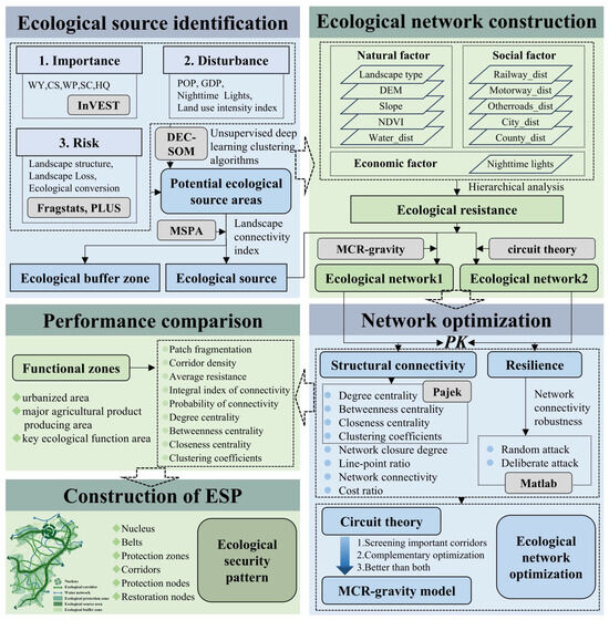
Figure 2.
Technical framework diagram.
2.3.1. Ecological Source Analysis
Ecological sources are important elements of the ESP and preserve functional stability and ecological security [29]. Potential ecological sources were identified using DEC-SOM in combination with the importance, disturbance, and risk of ESs, and the final ecological sources were extracted with the help of MSPA and landscape connectivity index analysis.
- Importance assessment
ESs encompass the ecological products and benefits that are obtained by human beings, in either a direct or indirect manner, from ecosystems [30]. Considering the ecological resource conditions in Jiangxi Province, five types of ES were selected, namely, water yield (WY), water purification (WP), carbon storage (CS), soil conservation (SC), and habitat quality (HQ), which were measured via the InVEST model, normalized, and assessed using an equal weighted sum approach. Table 2 shows the formulas of the ESs.
Table 2.
Formulas for measuring ESs.
- 2.
- Disturbance assessment
Human disturbance has the most prominent impact on the ESP, which is manifested mainly in terms of habitat destruction, ecological cycle obstruction, biodiversity decline, and ecosystem stability reduction. In this study, population density, GDP, nighttime light, and the land use intensity index (LUI) were applied to characterize the level of ecosystem disturbance, and each type of index was normalized to assess the degree of ecosystem disturbance via equally weighted summation. The LUI reflects the intensity of disturbance to land use caused by human activities at a certain time in a specific area and further reflects the spatial demand of humans for ecosystems. The formula was as follows:
In Formula (1), ILUI represents the land use intensity index; Ai and Ci represent the area share and the intensity coefficient of the ith land use type, respectively. Notably, according to previous research [37] and actual conditions, Ci was assigned values of 1 for unutilized land, 2 for forestland, grassland, and watershed, 5 for arable land, and 10 for construction land.
- 3.
- Risk assessment
Landscape structure risk (LSR) mainly refers to the potential risk to the landscape pattern when external disturbances such as natural and anthropogenic disruptions occur. In this study, the largest patch index (LPI), Shannon’s diversity index (SHDI), and aggregation index (AI) [38] were selected to reflect the scale, spatial heterogeneity, aggregation and dispersion, respectively, to assess the LSR comprehensively. The calculation of each index was performed with the help of the Fragstats 4.3 tool.
Landscape loss risk (LLR) refers to the extent to which the natural properties of ecosystems in various landscapes are lost due to external disturbances, including natural and anthropogenic disturbances. This research uses the landscape intrusiveness index (LII) and landscape vulnerability index (LVI) to measure the landscape loss degree index (LLDI), and the corresponding formulas are as follows:
In Formula (2), LLDIi is the landscape loss degree index of the ith cell, LIIi is the landscape intrusiveness index of the ith cell, and LVIi is the landscape vulnerability index of the ith cell. The formula for calculating the LII [39,40] is as follows:
In Formulas (3)–(6), PD represents the degree of fragmentation; SPLIT represents the degree of separation; DIVISION represents the degree of landscape subdimensionality; 0.5, 0.3, and 0.2 denote the weights of PD, SPLIT, and DIVISION, respectively; NP represents the patch number; A represents the overall landscape area; Dij and Aij represent the distance index and area index of landscape i, respectively; C represents the patch perimeter; and B represents the patch area.
The LVI was classified into 6 levels based on previous studies and combined with the regional landscape types: construction land, 1; forest, 2; grassland, 3; arable land, 4; water, 5; and unutilized land, 6. The vulnerability grade of each type of land use was normalized.
Ecological land conversion risk refers to the decline in ESs caused by the conversion of ecological land to nonecological land during the process of urbanization. In this study, the PLUS model [41] was used to simulate the land conversion process. The driving factors included DEM, slope, aspect, SSD, TEM, RHU, PRE, EVP, NDVI, soil type, GDP, population density, nighttime light level, railway_dist, water_dist, motorway_dist, trunk_dist, secondary_dist, city_dist, county_dist, and rural settlement_dist. The 2020 data were then predicted based on the 1990 data, and the accuracy was calibrated with actual data from 2020. Finally, land use data from 2050 were used to analyze the risk of ecological land conversion.
- 4.
- Deep embedded clustering–self-organizing map (DEC–SOM)
DEC and SOM are both unsupervised deep learning clustering algorithms [42,43,44]. DEC has strong advantages in deep feature learning, nonlinear mapping, clustering accuracy, and applicable data structure complexity. SOM has strong advantages in terms of data visualization, preservation of topological structure, and explanatory properties. In this study, the two were combined to exploit their respective advantages fully to identify potential ecological sources through unsupervised deep learning clustering algorithms, which are more adaptable to the fusion of multiple ecological factors than traditional source identification methods are. Moreover, this approach avoids bias due to the subjectivity of the threshold setting, avoids the loss of the original attributes of the data due to the data superposition process, retains the spatial topology of ecosystems, and guarantees the continuity of the sources.
- 5.
- Morphological spatial pattern analysis (MSPA)
MSPA refers to discrimination and identification; at the image metric level, habitat patches are crucial for landscape connectivity [45]. In the reclassification process, grassland, woodland, and water are set as the foreground; arable land, unused land, and construction land are set as the background. MSPA yielded seven landscape types, core areas were extracted, and intersections with the above potential sources relying on DEC–SOM were used as the preliminary ecological source areas.
- 6.
- Landscape connectivity analysis
The landscape connectivity index is a crucial approach in landscape ecology for quantifying the degree of spatial connectivity of landscape elements. In this study, the landscape connectivity index was introduced to identify important ecological sources, not only by focusing on the quality of source patches but also by accurately identifying important core patches that are critical to the integrity of regional ecological processes from the perspective of the overall ecological function of the landscape. This will improve the scientific quality of source identification and maintain the stability and persistence of ecological processes. Combined with relevant studies [46,47], this study used the probability of connectivity (PC) and integral index of connectivity (IIC) to quantify the connectivity of the preliminary ecological sources and then screened out the final sources. The formulas are as follows:
In Formulas (7)–(9), PC represents the probability of connectivity; IIC represents the integral index of connectivity; and represent the areas of source i and source j, respectively; represents the maximum probability of species dispersal between source i and source j; represents the total area of the research area; represents the number of connections between source i and source j; dI(%) represents the degree of removal; I represents the landscape connectivity index PC and IIC, respectively; and represents the remaining connectivity index value after a source is removed.
2.3.2. EN Construction
- Analysis of resistance
Combined with the literature [48,49] and three experts in the field of ecology, 11 resistance factors covering natural, social, and economic aspects were selected, and the landscape type was assigned based on resistance, with forestland as 1, water as 2, grassland as 3, arable land as 4, unutilized land as 5, and construction land as 6; then, various types of resistance factors were normalized. We used hierarchical analysis to determine the weight of the resistance factor. First, we collected the importance of each expert’s factor judgment matrix questionnaire. Each expert of each level judgment matrix consistency ratio was less than 0.1, indicating that through the consistency of the test, the distribution of the weight of each factor was more reasonable, and then the group decision-making panel was used to measure the weight of each factor (see Table 3).
Table 3.
Resistance factors and weights.
- 2.
- MCR gravity model
MCR is a model of the cost of consumption and depletion of biological species as they move to a destination from a source location; this approach is used to identify trends in biological migration flows and the potential for movement [19]. The gravity model reflects the intensity of the mutual interactions among ecological sources; thus, crucial corridors can be identified [50]. We identified potential corridors via the MCR method and extracted important corridors with a gravity model.
In Formula (10), MCR represents the minimum resistance to spreading from patch j to any other patch; f is a function; Dij represents the distance from patch source j to patch source i; and Ri represents the resistance coefficient of patch source i during its diffusion in an arbitrary direction in space.
In Formula (11), Gij represents the intensity of the mutual interaction between source areas i and j; Ni and Nj are weighting coefficients for source i and source j, respectively; Dij represents the value that has been standardized for the potential ecological corridor linking source i and source j; Pi and Pj represent the resistance values that correspond to source i and source j; Si and Sj are areas that correspond to source i and source j; Lij represents the cumulative value of resistance of corridors connecting source i and source j; and Lmax represents the maximum value of Lij.
- 3.
- Circuit theory
The choice of migration paths during the migration of biological species resembles the arbitrary roaming process in electronics, and resistance to migration is similar to the resistance of an electric circuit [51]. We introduced circuit theory, and ENs were constructed with the help of the ArcGIS-based tool Linkage Mapper.
2.3.3. Comparison of ENs
The ENs constructed with the two theoretical models were compared in terms of structural connectivity and resilience, and an optimal EN was obtained.
- Structural connectivity analysis
Based on graph theory, the sources and corridors were conceptualized as nodes and links, respectively, to construct a complicated network, and a network topology diagram was constructed [38]. The ENs constructed with the two methods were evaluated and compared, including degree centrality (D), betweenness centrality (B), closeness centrality (C), and clustering coefficients (CCs), and the above metrics were implemented by Pajek. The closure degree (α), line–point ratio (β), network connectivity (γ), and cost ratio (CR) were also introduced to further analyze network connectivity characteristics and network effectiveness [52]. The formulas are shown in Table 4.
Table 4.
Indicators of the structural connectivity of ENs.
- 2.
- Resilience analysis
EN resilience refers to the ability to resist and adapt to various kinds of disturbances, thus emphasizing the characteristics of an ecosystem that can maintain system functions and structural stability when it is disturbed. The concept of connectivity robustness reflects the capability of maintaining the stability of network connectivity with the remaining network elements when some network node elements are removed. In this study, the resilience of complex networks is assessed through connectivity robustness analysis. It is often necessary to assume specific scenarios for this purpose; we assume two scenarios, ‘random attack’ and ‘deliberate attack’, to compare their analysis results [56]. A random attack involves randomly deleting any node in the EN, whereas a deliberate attack involves deleting the nodes in a certain order. Because the degree of nodes has a vital influence on the connectivity of the EN, nodes are sorted and deleted sequentially according to their degree value. The corresponding formula [57] is as follows:
In Formula (12), Rc represents the robustness of the connectivity of the EN; Cmax represents the quantity of nodes included in the largest connected subgraph left in the network after some nodes have been deleted; N represents the quantity of all nodes; and Nr represents the quantity of nodes that have been deleted.
3. Results
3.1. Ecological Source Area Identification on the Basis of ‘Importance-Disturbance-Risk’
3.1.1. Identification of Potential Ecological Source Areas
According to Figure 3, among ES importance factors, WY is affected by the distribution of precipitation, which is typically greater in the northern areas than in the southern region and more pronounced in the eastern parts than in the west. CS is more uniformly distributed and has a higher overall level. Areas with high WP values are located primarily in the central and northern parts of the country. The distributions of SC and HQ is marked by lower levels in the middle and higher levels in the peripheral areas. Overall, high importance ratings were mainly observed in Pingxiang city in the west; the western part of Jiujiang city and the northwestern part of Yichun city; Jingdezhen city, Shangrao city, and Yingtan city in the northeast, along the provincial administrative boundary area; and Ganzhou city in the south, along the boundary of the provincial administrative area. Low importance ratings were observed in the north-central part, which is an area of hilly plains.
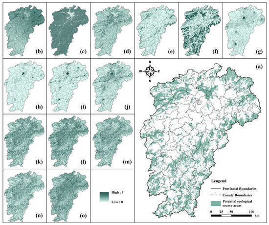
Figure 3.
Map of the results of the identification of potential ecological sources ((a): potential ecological sources; (b): WY; (c): CS; (d): WP; (e): SC; (f): HQ; (g): POP; (h): GDP; (i): nighttime lights; (j): LUI; (k): LPI; (l): SHDI; (m): AI; (n): LII; (o): LVI).
In terms of ES disturbance, high disturbance levels are present in the north-central area, which mainly includes established urban areas and the surrounding areas of cities such as Nanchang, Jiujiang, Shangrao, and Ganzhou, where human activities are relatively concentrated and occur frequently. The road traffic network is dense in these areas and has a notable impact on ecosystem disturbances. The regions in northwestern, northeastern and southern Ganzhou are dominated by primitive areas with mountainous and forested landforms, which have little impact on ecological disturbances.
The landscape structure risk (LPI, SHDI, AI) and landscape loss risk (LII, LVI) as a whole exhibit a distribution pattern characterized by high values in the central area and low values in the surrounding regions. They are distributed mainly in and around urban built-up areas, where human activities intensify frequently, land development and utilization intensity are high, landscape fragmentation is severe, and the vulnerability and sensitivity of ecosystems are high. According to the PLUS model prediction results, the kappa coefficient was 0.85, the overall accuracy was 0.92, and the accuracy was relatively high; thus, the predicted data can be used as the basis for assessing the conversion risk. The predictions indicated that the area of ecological land likely to be converted to nonecological land was 2992.17 km2.
Combining the above quantitative analysis of ES importance, disturbance, and risk, the DEC–SOM deep unsupervised learning clustering algorithm was applied to identify potential ecological sources. After removing areas at risk of ecological conversion, as well as fragmented patches smaller than 1 km2, potential source areas covering 53,962.47 km2 were obtained, accounting for 32.33% of the research area.
3.1.2. Ecological Source Extraction Analysis
According to the MSPA shown in Figure 4b, the core area was 36,626.71 km2, accounting for 21.94% of the research region. We carried out a spatial overlay analysis of the potential sources and the core area, and the overlapping region was used as the preliminary ecological source, which was 20,237.97 km2, representing 12.12% of the research region.
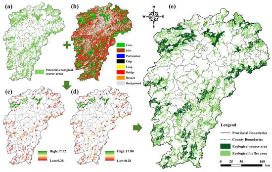
Figure 4.
Ecological source extraction analysis map ((a): potential ecological sources; (b): MSPA; (c): dIIC; (d): dPC; (e): ecological source area and buffer zone).
Based on the results of the dPC and dIIC measurements shown in Figure 4c,d, simultaneous screening by both dPC and dIIC can ensure that source patches have high importance under different connectivity indicators. Too high a value may miss patches with small but important contributions; too low a value results in an excessive number of source patches, making it difficult to highlight the key points. Based on experience, 1% is widely used to identify key source patches, which can effectively differentiate patches with significant contributions to connectivity, and ensure the stringency of screening while accounting for the representativeness of the patches and the network integrity; thus, source patches with dPC and dIIC greater than 1% were used as the final ecological sources, and 42 source patches were extracted, with an area of 14,831.07 km2 and a percentage of 8.88%, of which the largest source patch was 1713.19 km2, spanning national nature reserves such as Poyang Lake, Jiuling Mountain, Guanshan Mountain, Wuyi Mountain, Yangjifeng, Matou Mountain, Tongbo Mountain, Jiulian Mountain, Qiyun Mountain, Jinggang Mountain, Sanqing Mountain World Geopark, Wugong Mountain, Sanzhaolun, Tianzhu Peak, and Wufu Mountain National Forest Park and national scenic spots such as Mingyue Mountain and Sanbai Mountain. The remaining part of the potential sources was designated the ecological buffer zone, with an area of 39,131.41 km2 and a percentage of 23.44%, as shown in Figure 4e.
3.2. Establishment of Ecological Corridors via the MCR Gravity Model and Circuit Theory
3.2.1. Ecological Resistance Analysis
Following the normalization process, the distributions of the resistance of a single factor and the comprehensive resistance were obtained, as presented in Figure 5. In general, a spatial distribution characterized by high resistance in the central area and low resistance in the surrounding regions was strongly correlated with the natural geographic conditions and socioeconomic development of the study area. High resistance zones are situated in the hilly and plain region in the north-central region, mainly in and around the developed areas of cities and towns, as well as in the areas of railways, highways, and other important transport corridors, which are the main places for everyday life and production and limit the connectivity of the EN. Low resistance areas are chiefly spread throughout the northwestern, northeastern, southwestern, and southeastern regions, where mountain ranges are connected, vegetation cover is abundant, and human activities are limited, providing basic conditions for species migration and flow; at the same time, it is highly advantageous for biological migration, species exchange, and energy flow between different ecological patches.
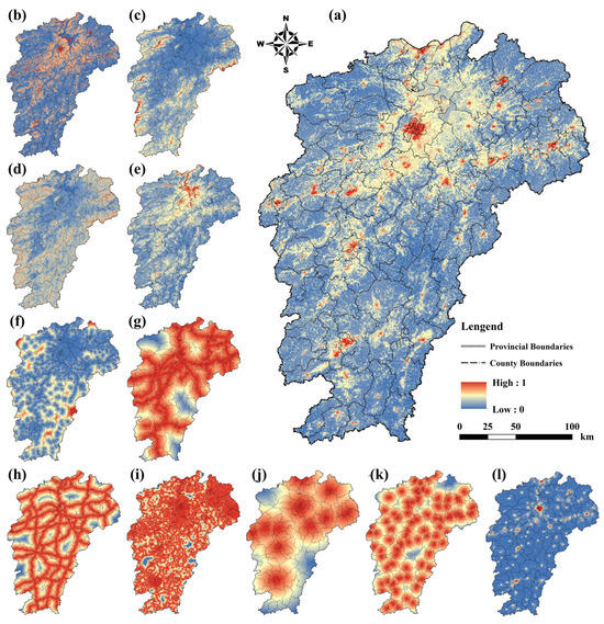
Figure 5.
Diagram of the resistance distribution ((a): comprehensive resistance; (b): landscape type; (c): DEM; (d): slope; (e): NDVI; (f): water_dist; (g): railway_dist; (h): motorway_dist; (i): otherroads_dist; (j): city_dist; (k): county_dist; (l): nighttime lights).
3.2.2. Ecological Corridor Analysis
- Constructing corridors via the MCR gravity model
We first obtained the distance and raster data for backtracking links via ArcGIS software. This was achieved using the Cost Distance tool to import the source, destination, and resistance values. We subsequently identified the minimum cost paths between every two sources sequentially. This step was implemented with the help of the Cost Path tool. In accordance with the above steps, we performed experiments for each of the 42 sources separately. In total, 861 ecological corridors were recognized. We calculated the intensity of the effect according to the gravity model and then screened 120 important corridors. Altogether, the length of these corridors amounted to 7477.44 km (for details, please refer to Figure 6a). Because the overall resistance in the central and northern areas was relatively high, the corridors were primarily situated in the marginal zones of the northwestern, northeastern, and southwestern regions.
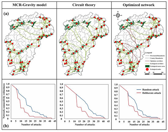
Figure 6.
Comparison and optimization of the ENs ((a): ENs; (b): resilience).
- 2.
- Constructing corridors based on circuit theory
We introduced circuit theory and obtained 106 corridors in total; their length was 7778.41 km. This result was obtained with the aid of the Linkage Mapper tool. Specifically, the analysis was carried out by entering the source and resistance data and running the Build Network and Map Linkages module. Figure 6a shows that the distribution of the corridors was fairly homogeneous, reaching every part of the region. The trends and scopes of the corridors were also quite different, with high regional connectivity. The corridors connect the northern and southern parts and the western and eastern parts of the region. These results are attributable to circuit theory, in which the random wandering and migration of biological species are considered.
3.3. Comparative Analysis of ENs on the Basis of Structural Connectivity and Resilience
3.3.1. Comparative Analysis of Structural Connectivity
Network topological structures were obtained with the MCR gravity model and circuit theory. The structural connectivity indices of the two model theories were measured separately and are shown in Table 5. Among the eight indices related to structural connectivity, seven, namely, degree centrality, betweenness centrality, closeness centrality, clustering coefficients, closure degree, line-point ratio, and network connectivity, were higher for the former than for the latter by 68.29%, 122.56%, 17.52%, 42.15%, 21.54%, 13.21% and 13.21%, respectively; additionally, the cost ratios were similar in both cases. Overall, the ENs constructed with the MCR gravity model displayed better closure and structural connectivity.
Table 5.
Comparison of EN structure connectivity indicators before and after optimization.
3.3.2. Comparative Analysis of Ecological Resilience
MATLAB R2024b was used to simulate random and deliberate attacks on the ENs constructed with the two models, and the robustness of network connections was determined to assess the changes in EN resilience, as shown in Figure 6b. With respect to the random attack state, the connection robustness of the former method rapidly decreased to 0.40, a decrease of 60%; when 88% of the nodes were deleted, the ENs almost reached a state of collapse. The connection robustness of the latter rapidly decreased to 0.15, a decrease of 85%; moreover, when 98% of the nodes were deleted, the ENs almost reached a state of collapse. The connectivity was reduced from 0.1 to 0 by removing 21% of the nodes in both cases. With respect to the deliberate attack state, the connection robustness of the former method rapidly decreased to 0.31, a decrease of 69%; when 76% of the nodes were deleted, the EN connectivity was almost completely lost, and the ecosystem was close to a state of collapse. The connection robustness of the latter method rapidly decreased to 0.32, a decrease of 68%; when 69% of the nodes were deleted, the ENs almost reached a state of collapse. In the process of decreasing the connectivity from 0.1 to 0, the former needed to remove 57% of the nodes, whereas the latter needed to remove only 43% of the nodes. In general, the ENs constructed by the MCR gravity model performed better in terms of the degradation angle in the random attack mode, whereas the circuit theory performed more persistently in the near-collapse state; the ENs constructed by the MCR gravity model performed more persistently in the near-collapse state and more persistently in the process of connectivity degradation from 0.1 to 0 in the deliberate attack mode, whereas the circuit theory performed better from the degradation perspective.
3.3.3. EN Optimization
According to the above comparative analysis, the MCR gravity model generally performed better than the circuit theory model did, but the circuit theory model has certain advantages; therefore, the important nodes involving corridors of the latter were used to enhance complement and optimize the ENs of the former method, subsequently enhancing the structural connectivity and robustness of the ENs. With respect to the 106 corridors established for the latter, the values of degree centrality, betweenness centrality, closeness centrality, and clustering coefficients were measured by removing the ecological nodes and corridors one by one, as shown in Figure 7. If the deletion of a node or corridor led to a sudden decrease in any of the above four indicators, the node and the corridor were considered vital for the structural connectivity and stability of the ENs. For the latter ENs, the degree centrality changed minimally; the closeness centrality decreased the most when nodes 16, 20, and 28 and corridors were deleted, by 7–20%; the betweenness centrality decreased sharply, by 11%, when nodes 28 and certain corridors were deleted; and the clustering coefficients decreased sharply, by 7–8%, when nodes 32 and 39 and corridors were deleted. Therefore, nodes 16, 20, 28, 32, and 39 and their connected corridors were considered more important for the efficiency and connectivity of the EN structure, and 27 ecological corridors were involved. Given the corridor results obtained with the MCR gravity model, 14 ecological corridors needed to be supplemented; following the supplementation and optimization process, we established 134 ecological corridors with a total length of 9111.78 km, as shown in Figure 6a.
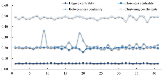
Figure 7.
Analysis of variations in the connectivity of network structure based on the circuit theory approach (nodes and ecological corridors involved were removed sequentially).
The eight indicators of structural connectivity were measured again for the optimized ENs and compared and analyzed with those in the preoptimization period, as shown in Table 5. The degree centrality, closeness centrality, closure degree, line-point ratio, and network connectivity all increased substantially, with degree centrality increasing the most, at 10.14% and 85.37% in the two cases, followed by the closure degree, at 17.72% and 43.08%, respectively. A comparison of the indicators indicated that the optimization of the ENs constructed with the MCR gravity model, as optimized with the important nodes and corridors from the circuit theory-based ENs, significantly improved the overall structural connectivity and connection efficiency. As shown in Figure 6b, for the optimized ENs and the two attack modes, the network connectivity robustness decreased sharply to 0.67 and 0.40, decreased by 33% and 60% in the two cases, respectively, and decreased in magnitude; the network approached a state of collapse after 95% and 76% of nodes were removed in the two attacked modes, respectively. Moreover, with the advancement of the attack process, as the ENs approached collapse, to decrease network connectivity robustness from 0.1 to 0, 33% and 50% of the nodes needed to be removed, respectively, and the decline frequency was slower. The overall performance of the optimized ENs in terms of resilience was slightly improved.
We obtained the resistance data for each corridor node and classified them into five classes. We made use of the natural breakpoint method to select the nodes with the highest resistance as the restoration nodes and nodes with the lowest resistance as the protection nodes (see Figure 8a). A total of 210 restoration nodes were designated; they were predominantly positioned in the central region, and the ecological corridors in these zones were long and had a wide span. Moreover, the corridors traversed urban built-up zones, densely populated zones in various counties and districts, and the peripheries of county towns. These areas have high population densities, and living and production activities are frequent there. These corridors are fragile and easy to block, so it is necessary to plan and step up efforts to implement ecological restoration projects, and related restoration measures to guarantee the connectivity of these corridors. Notably, network connectivity in the northern and central areas, and the western and eastern regions can be achieved by implementing ecological restoration measures, constructing ecological projects, and improving restoration practices. It was also important to enhance and optimize the regional ESP. A total of 280 nodes were designated for protection, which were chiefly spread in the zones where the ecological sources were densely distributed and had better ecological base conditions and abundant vegetation; therefore, it was necessary to implement key protection for the corresponding nodes to prevent damage to the ecological environment, ensure close connections between the ecological sources, and strengthen the exchange and flow of biological species.
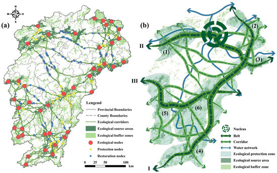
Figure 8.
ESP of Jiangxi Province ((a): distribution of key ecological elements; (b): ESP; I: Huaiyu Mountain–Wuyi Mountain–Jiulian Mountain Ecological Function Belt; II: Jiuling Mountain–Poyang Lake–Tongbo Mountain Ecological Function Belt; III: Wugong Mountain–Jinggang Mountain–Junfeng Mountain Ecological Function Belt; (1) Northwest Gan Ecological Protection Zone; (2) Northeast Gan Ecological Protection Zone; (3) East Gan Ecological Protection Zone; (4) South Gan Ecological Protection Zone; (5) West Gan Ecological Protection Zone; (6) Central-South Gan Ecological Protection Zone).
3.4. Comparative Analysis of EN Performance in Different Functional Control Zones
The main functional zones of Jiangxi Province included the urbanized area (UA), major agricultural product-producing area (MAPPA), and key ecological function area (KEFA). Overall, the ENs within the KEFA were located primarily in the periphery regions, involving longer ecological corridors and larger spans. The ENs within the KEFA involved the highest proportion of crossing forests and grasslands, 90.48%, and the lowest proportion of UAs, 78.19%. Forests and grasslands, the best geomorphological conditions for the migration of biological species and important parts of ENs, carry out the region’s important functions of water conservation, soil and water conservation, and biodiversity, which favor the connectivity and continuity of ENs.
In addition, this study used nine indicators for comparative analysis of ENs under different functional control zones. After normalization, the results in Figure 9 show that in the KEFA, six indicators, namely, fragmentation of source patches, corridor density, average resistance, IIC, PC, and clustering coefficients, were better than those in the UA and MAPPA, indicating that the source patches have high degrees of concentration and connectivity, relatively dense corridors, low resistance to species transfer between source areas, high EN connectivity, and close synergy and high degrees of clustering of ecological sources and networks in localized areas. Two indicators, betweenness centrality and closeness centrality, were better in the MAPPA, indicating that the source patches were more concentrated, with less resistance to biotic migration and high energy transfer and access efficiency. In the UA, the degree centrality was better, indicating that the ENs in the UA serve as important links to maintain local ecological connections and are important bridges through the regional north–south and east–west networks. Overall, the ENs in the KEFA had strong continuity and resilience, the ENs in the MAPPA had strong access efficiency, and the ENs in the UA had strong local interaction.
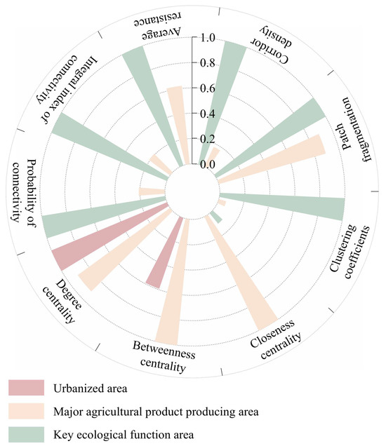
Figure 9.
Comparative analysis of EN performance in different functional control zones.
3.5. ESP Construction
We synthesized the spatial distributions of ecological sources, buffer zones, and corridors, and an ESP with ‘1 nucleus, 3 belts, 6 zones, and multiple corridors’ was constructed, as shown in Figure 8b. The nucleus refers to the ecologically protected Poyang Lake, which is the largest freshwater lake and the only member of the World Network of Life Lakes in China; the lake provides important regional biodiversity protection, floodwater storage, and other functions. It connects to the Gan River, Fuhe River and other major water networks. The 3 belts are the Huaiyu Mountain–Wuyi Mountain–Jiulian Mountain Ecological Function Belt, Jiuling Mountain–Poyang Lake–Tongbo Mountain Ecological Function Belt, and Wugong Mountain–Jinggang Mountain–Junfeng Mountain Ecological Function Belt, which are connected with crucial national preservation areas, forest parks, and places of scenic beauty in Jiangxi Province and together form ecological barriers in the east, north, south, and west, which are important parts of the regional ENs. The six zones are the Northwest Gan ecological protection zone, with an emphasis on enhancing the ecological function of water conservation near Jiuling Mountain; the Northeast Gan ecological protection zone, with an emphasis on enhancing water conservation and biodiversity near Huaiyu Mountain; the East Gan ecological protection zone, with a focus on strengthening biodiversity protection near Wuyi Mountain; the South Gan ecological protection zone, with the Gangjiangyuan–Dongjiangyuan–Beijiangyuan relation important for improving the quality of regional forests and strengthening water conservation functions and soil conservation functions; the West Gan ecological protection zone, with an emphasis on enhancing the water conservation function in the Luoxiao Mountains; and the Central-South Gan ecological protection zone, with a focus on improving the quality of forests and strengthening biodiversity conservation. Multiple ecological corridors connect various ecological sources, building environments and pathways for species migration and activities, enhancing EN connectivity and closure.
4. Discussion
4.1. ESP Construction Framework
Ecological sources are important ecological elements of the ESP, but it is important to determine which ecological patches are suitable as ecological sources [15]. ES is an important reflection of regional ecological function, and it is scientifically reasonable to use it as an important basis for identifying ecological sources. However, we cannot neglect the ecosystem interference associated with living and production activities, and nighttime light, land use intensity, and other data can help us identify the degrees of interference in different areas [58,59]. The risks to landscape structure, such as landscape fragmentation and dispersion, and the risk of functional loss due to processes such as natural destruction and human disruptions, in addition to the risk of ecological land conversion, are potential threats to the ecosystem and decrease ecological security. This study considered the above risk factors in a scientific and reasonable approach for avoiding ecological risks. Through an integrated assessment of the importance, disturbance, and risk of ESs, the quality, stability, and safety of the ecological source were considered from multiple dimensions, which provides a guarantee for the sustainability of the ecological source. The traditional method uses multifactor comprehensive evaluation, which can synthesize multiple dimensions to consider the overall quality of the ecological source, and provides an effective way of thinking for ecological source extraction. However, this method also has certain limitations, such as a certain degree of subjectivity in the process of determining the evaluation threshold, which may cause bias in the evaluation results. To avoid this limitation, we attempted to pass the DEC–SOM deep unsupervised learning algorithm, which can successfully transform high-dimensional data into a lower-dimensional form [5] with high clustering accuracy and is not only applicable to a variety of data complex structures but also retains the original data attributes and spatial topology structure, which respond to the complexity of the ecosystem. In this process, the interference of the subjective threshold is effectively avoided. This approach can provide a new method for the extraction of ecological sources.
Whether nonecological land can be used as an ecological source is also a matter of concern. ESs mainly encompass the products and values that ecosystems can provide, with an emphasis on service functions. Therefore, many nonecological land uses, such as farmland and other agricultural land, are highly important for ESs, impeding biological migration, species exchange, and energy flow. In the MSPA, we carried out further extraction of the ecological sources from the perspective of ecological land landscape patterns [60], with ecological land as the source and nonecological land as the buffer zone. We not only extracted the key ecological sources but also fully explored the crucial role of buffer zones in the ESP. Moreover, landscape connectivity is an important attribute of ecological sources, and good connectivity can promote the dispersal and movement of biological species along with the transport of energy, and maintain the stability and sustainability of ES functions. In this study, consideration of landscape connectivity was used to determine the ultimate ecological sources, which further ensured the overall connectivity between the sources and the integrity of the ENs [61].
The ecological resistance surface plays the role of the underlying logic in the process of constructing the ESP, which embodies the joint effects of natural elements and human activities and disturbances. By quantifying the magnitude of the obstruction of different landscape units to the ecological flow process, the optimal path is identified. The scientific rationality of the ecological resistance system determines the overall quality and connectivity efficiency of the ENs. In addition to the literature and experience, the participation mechanism of experts in the industry is particularly important. The scientific rationality of the ecological resistance system and the overall quality and efficiency of the ENs can be greatly improved through the decision-making of an expert group; the weights of the factors can be determined with the help of the hierarchical analysis method and the consistency test.
The MCR gravity model was used to construct ENs by considering minimum costs and the optimal paths of species migration and mobility, ignoring other factors that influence path selection [14]. Circuit theory, conversely, accounts for the random wandering properties of biological species, and path selection is more random [13]. The two models and theories have distinct advantages, and the ENs constructed differ. A comparison of the resilience and connectivity of the EN structures obtained with the two models revealed that the network constructed with the former was better in terms of closure and connectivity than that constructed with the latter approach. The circuit theory method was used to delete redundant nodes and corridors, extract the nodes and corridors that contribute most to the connectivity of the ENs and optimize the network constructed with the MCR gravity model. Compared with the two ENs obtained with the original models, the optimized ENs displayed greater connectivity and resilience. From the viewpoint of the distribution pattern, we strengthened the connections throughout the region in the north–south and east–west directions. Notably, connectivity among various ecological source areas improved, providing better conditions and more possibilities for biological migration, species exchange, and energy flow. The ENs were able to link national nature reserves, geological parks, forest parks, and scenic spots, which is beneficial for increasing regional ecological security.
In general, the ESP is a structural system composed of three types of spatial elements: points, lines and surfaces. Through the combination of points, lines and surfaces, it can systematically express the ecological spatial structure and reflect the continuity and integrity of the ecosystem. In this study, an ESP consisting of one nucleus, three belts, six zones, and multiple corridors was proposed by combining ecological sources and corridors. A single nucleus, as a vital ecological core area, had a decisive impact on the ecological security within the region. The three belts represented ecological spatial belts with a certain degree of continuity and distance spanning, which were distributed mainly along important mountain ranges and connected the ecological protection zones in important channels. The six zones were laid out according to the ecological resource concentration or group layout and were important for the protection of different protection areas in their respective regions. Different protection functions can be undertaken in their respective areas. The multicorridor layout is responsible for connecting source patches between and within the protected areas and represents an important channel for the diffusion and migration of organisms in the localized area. This regional ESP was jointly constructed through nuclei, belts, zones and corridors, which were essential for enhancing the continuity and integrity of regional ecosystems.
4.2. Significant Differences in EN Performance Across Functional Zones
Combined with the analysis of EN performance in the main functional zones of Jiangxi Province, we found that the concentration of source areas within the KEFA was high, the corridors were relatively dense, the resistance of species transferring to each other between source areas was small, the EN connectivity was high, and the ecological source areas and networks within the local area were closely synergized and had a high degree of clustering. The source patches in the MAPPA were more concentrated, with less resistance to biological migration and high efficiency of energy transfer and access. The ENs in the UA serve as important links to maintain local ecological associations and are important bridges that function through regional north–south and east–west networks. This is related to land use intensity, ecological resource endowment, and disturbance caused by anthropogenic activities. By sorting out the mechanism of transmission paths between dominant functions and ENs, the UA shows a transmission path of economic dominance–land use expansion–encroachment of ecological land use–network blockage in the process of urbanization. The performance of the ENs in the MAPPA is affected by two aspects due to the conflict between food production and ecological protection objectives. On the one hand, contiguous arable land provides channel conditions for species to diffuse and migrate and enhances the connectivity of ENs; on the other hand, disturbances caused by anthropogenic activities, such as mechanized operations and small-area arable land development, aggravate the fragmentation of ecological patches, which has a certain impact on the connectivity of ENs. The superior performance of the ENs in the KEFA further reflects rigid control and the resulting effect on ecological protection. The comparative analysis of EN performance under different functional control zones offers a reference for the subsequent development of relevant planning and control strategies. The UA needs to reconstruct the planning logic of ecological priority, reserve ecological corridors in urban renewal, and, at the same time, combine them with ecological restoration and protection nodes to strengthen the restoration and protection of key patches, improve patch contiguity, and enhance the connectivity of the ENs through the creation of urban green corridors. The MAPPA needs to enhance the synergistic development of the dual objectives of food production and ecological protection, limit the development of small arable land, and reserve potential corridors with the help of ecological field cans and other farming facilities. The KEFA should strictly strengthen management and protection. On the one hand, the internal quality should be strengthened; on the other hand, the internal and external linkages should be realized through the radiation of the ecological protection effect and the linkage of the surrounding area’s ecological quality, with a focus on strengthening the EN buffer between the KEFA, UA, and MAPPA to enhance the overall network performance of the region.
4.3. Recommendations for ESP Measures
The ESP is extremely valuable for ensuring ecosystem health, promoting coordinated regional development and safeguarding regional security. To further facilitate ecological security through the protection and restoration of crucial ecological elements [14], the following suggestions are proposed. First, the ecological nucleus of Poyang Lake should be better protected, the ecosystem of Poyang Lake and the wetland in the lake area should be preserved, preventive and control plans should be established in advance for droughts and floods caused by seasonal rains, the water level should be reasonably regulated, the biodiversity of Poyang Lake should be enhanced, and the lake water quality should be enhanced to guarantee the security of the water environment. Second, ecological protection barriers should be built in the southern, eastern, northern and western regions of China. Moreover, forest quality should be improved, and ecological restoration projects should be implemented for mountains and forests through vegetation restoration, soil improvement, pest and disease control, and related measures. The region’s water conservation, biodiversity, flood storage, carbon fixation, and soil conservation mechanisms should be enhanced; national parks should be created based on the system of nature reserves; and the protection of the habitats of migratory birds, aquatic animals and terrestrial animals should be enhanced, with additional diversity protection. Third, the ecological network should include corridors of high resistance around urban built-up zones, densely populated zones in counties and districts, and the peripheries of county towns, and during the subsequent national development and utilization of land, potential ecological patches should be considered for conversion into ecolands based on regional resource endowments [62]. To further strengthen the ecological land base and its functional additivity and establish or restore important nodes, we should focus on restoration and protection. It is essential that measures such as regreening and replanting be implemented to increase the sustainability of ecosystems. Fourth, internal ecological elements should be used to strengthen landscape connectivity, reconstruction and restoration via the establishment of protection nodes given the available ecological resources and ecological functions across multiple nodes. Ecosystem construction should occur from points to lines and then to the surface, with activities such as human production and construction limited from causing interference and damage to ecological land. Through the above systematic management and restoration process, a regional ESP can be constructed, laying a foundation for preserving national and regional ecological security and accelerating the construction of a beautiful Jiangxi model in China.
4.4. Limitations of the Study
The control of the ESP is not as rigid as those of the three zones and three lines but is more appropriately called flexible control. The construction of ESPs is closely related to ecological resource conditions. Although the applicability of the ESPs of one nucleus, three belts, six zones, and multiple corridors constructed in this study in other regions has yet to be demonstrated, the framework of the technical routes adopted can provide certain references and lessons for regions with different study scales and different ecological resource conditions. The traditional integrated superposition extraction method for ecological sources is improved with the help of the DEC–SOM deep unsupervised learning clustering algorithm and the inclusion of structural connectivity indicators. The ecological resistance surface system is constructed by combining the a priori basis and expert participation mechanism. The ENs are constructed and optimized by comparing the MCR gravity model with circuit theory to improve the limitations of the network constructed using a single model. The performances of ENs in different function control zones were compared, and the ESP was constructed by combining ecological elements. However, this study has several limitations. First, we recognized ecological sources from the perspective of ES importance, disturbance, and risk, whereas in the process of urbanization promotion, the harmonious development of economic growth and ecological conservation is desirable. However, because most of the data of economic indicators are panel data, which cannot be vectorized, only the nighttime lighting indicators that can reflect economic factors were considered. Other excessive economic factor indicators were not considered. Second, owing to the limitations of basic data, this study could not analyze the evolution trend of the ESP through time series. In the future, we will apply this framework at the city and county scales, the watershed scale, or in other regions with specific ecological resource conditions to further validate the adaptability of this research framework. Owing to the availability of data, we will consider more economic factor indicators to be included in the ecological source area indicator system and explore the evolution trend of the ESP over a long time series.
5. Conclusions
With an ecological civilization demonstration area (Jiangxi Province) as an example, this study integrated relevant methods and theories in the ecological field, and a new research framework for ESP was proposed. First, by evaluating the importance–disturbance–risk of ESs, ecological sources were identified through DEC–SOM, and landscape connectivity indicators were combined, and 42 ecological source regions were recognized. The area of these sources was 14,831.07 km2, and the ecological buffer zone was 39,131.41 km2. Second, ecological corridors were constructed based on the MCR gravity model and circuit theory. The connectivity and resilience of the EN structures were compared by applying the graph theory method to identify important nodes and corridors and optimize the ENs, which significantly improved structural connectivity and resilience. A total of 134 corridors were delineated; the total corridor length was 9111.78 km, and 210 restoration nodes and 280 protection nodes were identified. Third, the performance of the ENs in different functional control zones was compared, and the differences were significant, with strong continuity and resilience in the KEFA, strong access efficiency in the MAPPA, and strong local interaction in the UA. Finally, an ESP with ‘1 nucleus, 3 belts, 6 zones, and multiple corridors’ was constructed, and the key restoration measures and protection functions were clarified. This combination of key ecological elements to enhance regional ecological security offers a valuable reference for ecological management, protection and restoration; moreover, it provides a vital guiding function in preserving the health and sustainability of the ecosystem.
Author Contributions
Conceptualization, X.Y., H.C., X.Z. and H.Z.; methodology, X.Y.; software, X.Y.; validation, X.Y. and H.Z.; formal analysis, X.Y.; investigation, X.Y. and H.Z.; resources, H.C. and X.Z.; data curation, X.Y. and H.Z.; writing—original draft preparation, X.Y.; writing—review and editing, X.Y., H.C., X.Z. and H.Z.; visualization, X.Y. and H.Z.; supervision, H.C. and X.Z.; project administration, X.Z.; funding acquisition, X.Z. All authors have read and agreed to the published version of the manuscript.
Funding
This research was funded by the National Key R&D Program of China, grant number 2020YFD1100603-02 and 2023YFD2301303-1.
Data Availability Statement
The data presented in this study are available on request from the corresponding author.
Conflicts of Interest
The authors declare no conflicts of interest.
References
- Sun, Y.; Zhang, X.; Ding, Y.; Chen, D.; Qin, D.; Zhai, P. Understanding Human Influence on Climate Change in China. Natl. Sci. Rev. 2022, 9, nwab113. [Google Scholar] [CrossRef]
- Hong, W.; Li, Y.; Yang, X.; Guo, R.; Liang, M.; Li, X. Identification of Intercity Ecological Synergy Regions and Measurement of the Corresponding Policy Network Structure: A Network Analysis Perspective. Landsc. Urban Plan. 2024, 245, 105008. [Google Scholar] [CrossRef]
- Cao, W.; Li, X.; Lyu, X.; Dang, D.; Wang, K.; Li, M.; Liu, S. To Explore the Effectiveness of Various Ecological Security Pattern Construction Methods in Many Growth Situations in the Future: A Case Study of the West Liaohe River Basin in Inner Mongolia. Sci. Total Environ. 2024, 948, 174607. [Google Scholar] [CrossRef]
- Zhang, F.; Jia, Y.; Liu, X.; Li, T.; Gao, Q. Application of MSPA-MCR Models to Construct Ecological Security Pattern in the Basin: A Case Study of Dawen River Basin. Ecol. Indic. 2024, 160, 111887. [Google Scholar] [CrossRef]
- Gong, D.; Huang, M.; Ge, Y.; Zhu, D.; Chen, J.; Chen, Y.; Zhang, L.; Hu, B.; Lai, S.; Lin, H. Revolutionizing Ecological Security Pattern with Multi-Source Data and Deep Learning: An Adaptive Generation Approach. Ecol. Indic. 2025, 173, 113315. [Google Scholar] [CrossRef]
- Forman, R.T.T. Some General Principles of Landscape and Regional Ecology. Landsc. Ecol. 1995, 10, 133–142. [Google Scholar] [CrossRef]
- Wang, T.; Li, H.; Huang, Y. The Complex Ecological Network’s Resilience of the Wuhan Metropolitan Area. Ecol. Indic. 2021, 130, 108101. [Google Scholar] [CrossRef]
- Wang, Z.; Shi, P.; Zhang, X.; Tong, H.; Zhang, W.; Liu, Y. Research on Landscape Pattern Construction and Ecological Restoration of Jiuquan City Based on Ecological Security Evaluation. Sustainability 2021, 13, 5732. [Google Scholar] [CrossRef]
- Li, S.; Xiao, W.; Zhao, Y.; Lv, X. Incorporating Ecological Risk Index in the Multi-Process MCRE Model to Optimize the Ecological Security Pattern in a Semi-Arid Area with Intensive Coal Mining: A Case Study in Northern China. J. Clean. Prod. 2020, 247, 119143. [Google Scholar] [CrossRef]
- Zhang, Y.; Yang, R.; Sun, M.; Lu, Y.; Zhang, L.; Yin, Y.; Li, X. Identification of Spatial Protection and Restoration Priorities for Ecological Security Pattern in a Rapidly Urbanized Region: A Case Study in the Chengdu–Chongqing Economic Circle, China. J. Environ. Manag. 2024, 366, 121789. [Google Scholar] [CrossRef]
- Liu, M.; Peng, J.; Dong, J.; Jiang, H.; Xu, D.; Meersmans, J. Trade-Offs of Landscape Connectivity between Regional and Interregional Ecological Security Patterns in a Junction Area of Beijing-Tianjin-Hebei Region. Appl. Geogr. 2024, 167, 103272. [Google Scholar] [CrossRef]
- Wang, Y.; Yang, X.; Zhang, X.; Zhu, L.; Wang, X.; Li, Y.; Zhou, L.; Yu, X. Spatiotemporal Dynamic Characteristics and Conservation Strategy of Ecological Security Pattern in a Rapidly Urbanizing Zone. Ecol. Indic. 2024, 166, 112457. [Google Scholar] [CrossRef]
- Zhang, L.; Liu, Q.; Wang, J.; Wu, T.; Li, M. Constructing Ecological Security Patterns Using Remote Sensing Ecological Index and Circuit Theory: A Case Study of the Changchun-Jilin-Tumen Region. J. Environ. Manag. 2025, 373, 123693. [Google Scholar] [CrossRef]
- Li, W.; Liu, Y.; Lin, Q.; Wu, X.; Hao, J.; Zhou, Z.; Zhang, X. Identification of Ecological Security Pattern in the Qinghai-Tibet Plateau. Ecol. Indic. 2025, 170, 113057. [Google Scholar] [CrossRef]
- Jiao, Z.; Wu, Z.; Luo, Y.; Wei, B.; Dai, Z.; Li, S. A Framework for Analyzing the Effects of Modifiable Areal Unit Problem on Ecological Security Pattern. J. Clean. Prod. 2024, 458, 142549. [Google Scholar] [CrossRef]
- Wang, C.; Yu, C.; Chen, T.; Feng, Z.; Hu, Y.; Wu, K. Can the Establishment of Ecological Security Patterns Improve Ecological Protection? An Example of Nanchang, China. Sci. Total Environ. 2020, 740, 140051. [Google Scholar] [CrossRef]
- Luo, X.; Le, F.; Zhang, Y.; Zhang, H.; Zhai, J.; Luo, Y. Multi-Scenario Analysis and Optimization Strategy of Ecological Security Pattern in the Weihe River Basin. J. Environ. Manag. 2024, 366, 121813. [Google Scholar] [CrossRef] [PubMed]
- Wang, J.; Bai, Y.; Huang, Z.; Ashraf, A.; Ali, M.; Fang, Z.; Lu, X. Identifying Ecological Security Patterns to Prioritize Conservation and Restoration: A Case Study in Xishuangbanna Tropical Region, China. J. Clean. Prod. 2024, 444, 141222. [Google Scholar] [CrossRef]
- Chen, W.; Liu, H.; Wang, J. Construction and Optimization of Regional Ecological Security Patterns Based on MSPA-MCR-GA Model: A Case Study of Dongting Lake Basin in China. Ecol. Indic. 2024, 165, 112169. [Google Scholar] [CrossRef]
- Sun, D.; Wu, X.; Wen, H.; Ma, X.; Zhang, F.; Ji, Q.; Zhang, J. Ecological Security Pattern Based on XGBoost-MCR Model: A Case Study of the Three Gorges Reservoir Region. J. Clean. Prod. 2024, 470, 143252. [Google Scholar] [CrossRef]
- Teng, M.; Wu, C.; Zhou, Z.; Lord, E.; Zheng, Z. Multipurpose Greenway Planning for Changing Cities: A Framework Integrating Priorities and a Least-Cost Path Model. Landsc. Urban Plan. 2011, 103, 1–14. [Google Scholar] [CrossRef]
- Xu, A.; Hu, M.; Shi, J.; Bai, Q.; Li, X. Construction and Optimization of Ecological Network in Inland River Basin Based on Circuit Theory, Complex Network and Ecological Sensitivity: A Case Study of Gansu Section of Heihe River Basin. Ecol. Model. 2024, 488, 110578. [Google Scholar] [CrossRef]
- Liao, Q.; Li, T.; Wang, Q.; Liu, D. Exploring the Ecosystem Services Bundles and Influencing Drivers at Different Scales in Southern Jiangxi, China. Ecol. Indic. 2023, 148, 110089. [Google Scholar] [CrossRef]
- Gu, K.; Ma, L.; Xu, J.; Yu, H.; Zhang, X. Spatiotemporal Evolution Characteristics and Driving Factors of Water Conservation Service in Jiangxi Province from 2001 to 2020. Sustainability 2023, 15, 11941. [Google Scholar] [CrossRef]
- Duan, P.; Xu, Y.; Guo, X.; Luo, Z.; Zhao, X. Study on Multi-Scale Characteristics and Influencing Factors of Trade-Offs and Synergies between Ecosystem Services in Jiangxi Province. Forests 2023, 14, 598. [Google Scholar] [CrossRef]
- Wang, M.; Wang, X.; Shi, W. Exploring the Response of Trade-Offs and Synergies among Ecosystem Services to Future Land Use Changes in the Hilly Red Soil Region of Southern China. J. Environ. Manag. 2024, 372, 123283. [Google Scholar] [CrossRef] [PubMed]
- Hu, B.; Xie, M.; He, R.; Shi, Z.; Zhou, Y.; Ni, H.; Li, H. Spatio-Temporal Evolution of Cropland Ecosystem Services Value and Its Spatially Varying Dominate over the Past Two Decades: A Case Study in Jiangxi Province in Southern China. J. Clean. Prod. 2023, 427, 139228. [Google Scholar] [CrossRef]
- Yan, F.; Shangguan, W.; Zhang, J.; Hu, B. Depth-to-Bedrock Map of China at a Spatial Resolution of 100 Meters. Sci. Data 2020, 7, 2. [Google Scholar] [CrossRef]
- Qian, M.; Huang, Y.; Cao, Y.; Wu, J.; Xiong, Y. Ecological Network Construction and Optimization in Guangzhou from the Perspective of Biodiversity Conservation. J. Environ. Manag. 2023, 336, 117692. [Google Scholar] [CrossRef]
- Costanza, R.; d’Arge, R.; De Groot, R.; Farber, S.; Grasso, M.; Hannon, B.; Limburg, K.; Naeem, S.; O’neill, R.V.; Paruelo, J.; et al. The Value of the World’s Ecosystem Services and Natural Capital. Nature 1997, 387, 253–260. [Google Scholar] [CrossRef]
- Wu, L.; Luo, Y.; Pang, S.; Wang, G.; Ma, X. Factor Analysis of Hydrologic Services in Water-Controlled Grassland Ecosystems by InVEST Model and Geodetector. Environ. Sci. Pollut. Res. 2024, 31, 20409–20433. [Google Scholar] [CrossRef]
- Zhang, L.; Hickel, K.; Dawes, W.R.; Chiew, F.H.S.; Briggs, P.R. A Rational Function Approach for Estimating Mean Annual Evapotranspiration. Water Resour. Res. 2004, 40, W02502. [Google Scholar] [CrossRef]
- Babbar, D.; Areendran, G.; Sahana, M.; Sarma, K.; Raj, K.; Sivadas, A. Assessment and Prediction of Carbon Sequestration Using Markov Chain and InVEST Model in Sariska Tiger Reserve, India. J. Clean. Prod. 2021, 278, 123333. [Google Scholar] [CrossRef]
- Lu, Y.; Qin, F. Improvements in the InVEST Water Purification Model for Detecting Spatio-Temporal Changesintotal Nitrogen and Total Phosphorus Discharges in the Huai River Watershed, China. J. Environ. Manag. 2024, 366, 121918. [Google Scholar] [CrossRef] [PubMed]
- Hamel, P.; Chaplin-Kramer, R.; Sim, S.; Mueller, C. A New Approach to Modeling the Sediment Retention Service (InVEST 3.0): Case Study of the Cape Fear Catchment, North Carolina, USA. Sci. Total Environ. 2015, 524–525, 166–177. [Google Scholar] [CrossRef] [PubMed]
- Zhang, K.; Fang, B.; Zhang, Z.; Liu, T.; Liu, K. Exploring Future Ecosystem Service Changes and Key Contributing Factors from a “Past-Future-Action” Perspective: A Case Study of the Yellow River Basin. Sci. Total Environ. 2024, 926, 171630. [Google Scholar] [CrossRef] [PubMed]
- Li, S.; Bing, Z.; Jin, G. Spatially Explicit Mapping of Soil Conservation Service in Monetary Units Due to Land Use/Cover Change for the Three Gorges Reservoir Area, China. Remote Sens. 2019, 11, 468. [Google Scholar] [CrossRef]
- Shen, Z.; Wu, W.; Tian, S.; Wang, J. A Multi-Scale Analysis Framework of Different Methods Used in Establishing Ecological Networks. Landsc. Urban Plan. 2022, 228, 104579. [Google Scholar] [CrossRef]
- Karimian, H.; Zou, W.; Chen, Y.; Xia, J.; Wang, Z. Landscape Ecological Risk Assessment and Driving Factor Analysis in Dongjiang River Watershed. Chemosphere 2022, 307, 135835. [Google Scholar] [CrossRef]
- Mo, W.; Wang, Y.; Zhang, Y.; Zhuang, D. Impacts of Road Network Expansion on Landscape Ecological Risk in a Megacity, China: A Case Study of Beijing. Sci. Total Environ. 2017, 574, 1000–1011. [Google Scholar] [CrossRef]
- Luo, J.; Fu, H. Construct the Future Wetland Ecological Security Pattern with Multi-Scenario Simulation. Ecol. Indic. 2023, 153, 110473. [Google Scholar] [CrossRef]
- Han, T.; Luo, J.; Gan, Y.; Sun, Y.; Tian, L. Synergistic Zoning and Management Strategies for Ecosystem Service Value and Ecological Risk at the County Level: A Case Study of Songzi City, Hubei Province, China. Land 2025, 14, 1021. [Google Scholar] [CrossRef]
- Xie, J.; Girshick, R.; Farhadi, A. Unsupervised Deep Embedding for Clustering Analysis. In Proceedings of the 33rd International Conference on Machine Learning (ICML 2016), New York, NY, USA, 19–24 June 2016. [Google Scholar]
- Zhou, J.; Yang, J.; Tang, Z.; Xue, L.; Zhang, W.; Zhang, J. Driving Mechanisms of Ecosystem Services and Their Trade-Offs and Synergies in the Transition Zone between the Qinghai-Tibet Plateau and the Loess Plateau. Ecol. Indic. 2025, 171, 113148. [Google Scholar] [CrossRef]
- Soille, P.; Vogt, P. Morphological Segmentation of Binary Patterns. Pattern Recognit. Lett. 2009, 30, 456–459. [Google Scholar] [CrossRef]
- Bai, H.; Zhang, Y.; Huang, J.; Chen, H. Constructing Ecological Networks and Analyzing Impact Factors in Multi-Scenario Simulation under Climate Change. Land 2025, 14, 1120. [Google Scholar] [CrossRef]
- Cao, C.; Luo, Y.; Xu, L.; Xi, Y.; Zhou, Y. Construction of Ecological Security Pattern Based on InVEST-Conefor-MCRM: A Case Study of Xinjiang, China. Ecol. Indic. 2024, 159, 111647. [Google Scholar] [CrossRef]
- Pickett, S.T.A.; Cadenasso, M.; Rosi, E.; Belt, K.; Groffman, P.; Grove, M.; Irwin, E.; Kaushal, S.; LaDeau, S.; Nilon, C.; et al. Dynamic Heterogeneity: A Framework to Promote Ecological Integration and Hypothesis Generation in Urban Systems. Urban. Ecosyst. 2017, 20, 1–14. [Google Scholar] [CrossRef]
- Qin, X.; Ling, H.; Shan, Q.; Zhang, G.; Yan, J.; Gong, Y.; Xu, J.; Meng, X. Construction of Ecological Security Patterns in Typical Arid Regions Based on the Synergy of Efficient Ecological Water Utilization and Environmental Quality Enhancement. Catena 2025, 249, 108713. [Google Scholar] [CrossRef]
- Ghasemi, A.; Miandoabchi, E.; Soroushnia, S. The Attractiveness of Seaport-Based Transport Corridors: An Integrated Approach Based on Scenario Planning and Gravity Models. Marit. Econ. Logist. 2021, 23, 522–547. [Google Scholar] [CrossRef]
- Mcrae, B.H.; Dickson, B.G.; Keitt, T.H.; Shah, V.B. Using Circuit Theory to Model Connectivity in Ecology, Evolution, and Conservation. Ecology 2008, 89, 2712–2724. [Google Scholar] [CrossRef]
- Taylor, P.D.; Fahrig, L.; Merriam, H.G. Connectivity Is a Vital Element of Landscape Structure. Oikos 1993, 68, 571–573. [Google Scholar] [CrossRef]
- Freeman, L.C. Centrality in Social Networks Conceptual Clarification. Soc. Netw. 1978, 1, 215–239. [Google Scholar] [CrossRef]
- De Montis, A.; Caschili, S.; Mulas, M.; Modica, G.; Ganciu, A.; Bardi, A.; Ledda, A.; Dessena, L.; Laudari, L.; Fichera, C.R. Urban–Rural Ecological Networks for Landscape Planning. Land. Use Policy 2016, 50, 312–327. [Google Scholar] [CrossRef]
- Haggett, P.; Richard, J.C. Network Analysis in Geography; Edward Arnold: London, UK, 1969. [Google Scholar]
- Huang, X.; Ye, Y.; Zhao, X.; Guo, X.; Ding, H. Identification and Stability Analysis of Critical Ecological Land: Case Study of a Hilly County in Southern China. Ecol. Indic. 2022, 141, 109091. [Google Scholar] [CrossRef]
- Zou, Z.; Xiao, Y.; Gao, J. Robustness Analysis of Urban Transit Network Based on Complex Networks Theory. Kybernetes 2013, 42, 383–399. [Google Scholar] [CrossRef]
- Gao, F.; Liao, S.; Wang, Z.; Cai, G.; Feng, L.; Yang, Z.; Chen, W.; Chen, X.; Li, G. Revealing Disparities in Different Types of Park Visits Based on Cellphone Signaling Data in Guangzhou, China. J. Environ. Manag. 2024, 351, 119969. [Google Scholar] [CrossRef] [PubMed]
- Zhang, R.; Liu, H.; Xu, Z.; Zhao, X.; Wen, L.; Zhuo, Y.; Wang, L. Ecological Problem Identification Based on Spatial and Temporal Dynamics of Ecosystem Quality: A Case Study. Ecol. Indic. 2025, 170, 112987. [Google Scholar] [CrossRef]
- Su, J.; Wu, M.; Liu, Z. Spatial–Temporal Evolution of Ecological Network Structure during 1967–2021 in Yongding River Floodplain. Land 2025, 14, 930. [Google Scholar] [CrossRef]
- Li, W.; Liang, X.; Jia, A.; Martin, J. The Impact of Nature Reserves on the Ecological Network of Urban Agglomerations—A Case Study of the Urban Agglomeration in the Middle Reaches of the Yangtze River. Land. 2025, 14, 1054. [Google Scholar] [CrossRef]
- Li, W. Effectiveness and Driving Mechanisms of Ecological Conservation and Restoration in Sichuan Province, China. Ecol. Indic. 2025, 172, 113238. [Google Scholar] [CrossRef]
Disclaimer/Publisher’s Note: The statements, opinions and data contained in all publications are solely those of the individual author(s) and contributor(s) and not of MDPI and/or the editor(s). MDPI and/or the editor(s) disclaim responsibility for any injury to people or property resulting from any ideas, methods, instructions or products referred to in the content. |
© 2025 by the authors. Licensee MDPI, Basel, Switzerland. This article is an open access article distributed under the terms and conditions of the Creative Commons Attribution (CC BY) license (https://creativecommons.org/licenses/by/4.0/).