1. Introduction
Extraction activities in a quarry are among the most intensive human interventions in the natural environment. They significantly change the relief of the landscape, break ecological connections and degrade soil properties, creating areas with a limited ability to regenerate naturally. The impacts of these activities often go beyond the boundaries of the mining area itself and leave long-term consequences for the functionality of the landscape. In the context of growing environmental challenges and the increasing emphasis on sustainable land use, the issue of restoring quarry areas is becoming extremely topical.
The transformation of areas disturbed by mining today represents more than just technical landscaping. It constitutes a comprehensive, multidisciplinary process requiring the coordinated application of ecological, legislative, technical, and social measures. The effectiveness of such interventions depends on their adaptation to local natural conditions, the applicable legal framework, and the degree of public acceptance [
1]. In addition, it is essential to account for regional specificities and the functional potential of restored areas, including the planning of their future use as an integral component of the recovery process [
2].
Recent studies have further refined this understanding by emphasizing strategic principles and models for effective landscape reconstruction. It has been emphasized that the reconstruction of the landscape should be part of a comprehensive vision established before any interventions are undertaken [
3]. This perspective was later expanded through the proposal of a holistic model that integrates biotechnical and geotechnical approaches [
4]. Moreover, the effectiveness of the implemented measures can be significantly enhanced by long-term monitoring based on a set of environmental indicators [
5].
In this context, there is a growing need for quantifiable tools that enable the objective assessment of reclamation success. One such contribution is the approach proposed in [
6], which introduced an integrated framework of indicators for the self-assessment of ecological restoration, particularly in degraded post-mining areas. This methodology emphasizes soil and microbial characteristics as key variables in evaluating ecological progress, especially in terms of functional habitat regeneration. Soil, as a dynamic and highly sensitive component of the landscape, plays a crucial role in the restoration process, influencing water retention, nutrient availability, vegetation succession, and the recolonization of microorganisms. As such, it is widely recognized as a suitable bioindicator for tracking both technical interventions and long-term ecological recovery. This concept is further supported by recent findings [
7], which confirm that soil and microbial parameters are among the most relevant indicators of ecological stability in the restoration of mining-disturbed areas.
A variety of methodological approaches for evaluating reclamation have gradually emerged, shaping current trends in the field. One such approach employs Multi-Criteria Decision Analysis (MCDA) as a theoretical framework for systematically comparing reclamation strategies, incorporating ecological, economic, and spatial planning considerations [
8]. This concept was further developed through its application under real-world conditions in an abandoned quarry in Greece, demonstrating the method’s capacity to support decision making in environments with elevated ecological burdens and complex restoration challenges [
9]. These findings confirmed that the MCDA serves not only as an analytical tool for strategy design, but also as a practical instrument for implementing restoration within specific spatial and temporal contexts. Nevertheless, a persistent challenge remains: the absence of a standardized set of evaluation criteria that would allow for consistent comparison and assessment of reclamation processes across different sites.
This need has been further acknowledged in the recent literature, which underscores that the lack of clear and universally accepted criteria hinders both the comparison of reclamation effectiveness and the practical implementation of restoration strategies [
10]. The issue is compounded by ongoing methodological fragmentation and the absence of standardized parameters that are applicable across diverse climatic and ecological contexts [
11].
In addition to technological and analytical tools, recent years have seen a growing emphasis on participatory approaches that incorporate the perspectives of the territory’s users into the evaluation process. The importance of post-occupancy evaluation (POE) has been highlighted as a means of verifying not only spatial functionality but also long-term public acceptance [
12]. This concept has been further extended to the context of reclaimed areas, where feedback from residents and visitors plays a pivotal role in assessing restoration outcomes [
13]. Unlike purely technical indicators, POE integrates subjective evaluations such as user satisfaction, perceived spatial quality, and actual patterns of use. The knowledge obtained through this approach significantly enhances the verification of restored landscape functionality in practice and serves as a valuable tool for aligning professional solutions with societal expectations.
A significant contribution to expert discourse on restoration planning was made through the recognition that restoration scenarios must be tailored to specific spatial conditions as a prerequisite for realistic planning, particularly in urbanized areas [
14]. Subsequent research emphasized the esthetic and recreational values of the land as essential components influencing social perception and the long-term sustainability of the restored landscape [
15]. These perspectives remain increasingly relevant today, as advanced environmental monitoring methods—particularly those based on remote sensing—are becoming more widely applied. For instance, hyperspectral analysis has been utilized to quantify heavy metals in reclaimed soils, establishing a basis for objectively measurable indicators of environmental quality [
16]. This development has been complemented by the application of the LandTrendr algorithm to satellite imagery time series, enabling long-term monitoring of mining disturbances and the progress of restoration efforts [
17]. Such tools not only allow for the precise assessment of ecological regeneration but also serve to validate the sustainability and social acceptance of reclamation strategies.
These findings clearly confirm that there is an acute need for a uniform, practically applicable method accepted by the professional community which would enable a systematic, reliable and comparable evaluation between sites of the quality of reclamation of areas disturbed by mining. Despite the number of available methodologies, there is still a lack of a standardized and interdisciplinary validated tool that would enable comparison of the quality of reclamation across different ecological and socio-spatial contexts, especially in the European area. At the same time, it is essential that such a framework reflects not only the ecological and technical aspects of restoration but also the wider social context, including the perception of the territory, its functional potential and sustainability from the perspective of landscape planning.
The presented study aims to bridge this gap and proposes a methodology for comprehensive evaluation of the quality of reclamation, which was created specifically for the needs of areas affected by open-pit mining. The proposed Reclamation Quality Index (RQI) is the result of a systematic selection and weighting of relevant indicators, which have been determined on the basis of expert consensus through a modified Delphi method. This multidimensional index integrates technical, ecological, pedological and social indicators to ensure not only scientific robustness but also practical applicability in real planning, monitoring and evaluation of restoration. RQI is designed to be used effectively not only by researchers but also by spatial development planners, environmental consultants and public authorities responsible for evaluating post-mining aftercare obligations.
2. Materials and Methods
Assessing the quality of quarry reclamation is an interdisciplinary challenge that requires integrating technical expertise with ecological, landscape, and socio-environmental knowledge. The design of the presented methodology draws on domestic expertise and a thorough comparison of international frameworks, paying particular attention to the concept of reference states according to best available practices, such as the Ecosystem Condition Typology (EEA), Land Degradation Neutrality (UNCCD), and Sustainability Index for Landscape Restoration (WRI), as well as global standards such as the Ecosystem Restoration Standards (SER), the Good Practice Guidelines for Sustainable Forest Management (FAO), and the Best Practice Guidelines for Extractive Sector Restoration (IUCN and ICMM).
These frameworks have significantly contributed to understanding the environmental state and evaluating the success of restoration, but they only rarely reflect the technical, geotechnical, and visual landscape specifics of reclamation typical of post-mining environments. Therefore, despite the number of existing approaches, there still lacks a uniform, standardized, and professionally validated tool that would enable a comprehensive and comparable evaluation of reclamation quality across ecologically and culturally diverse regions. Post-mining sites, in particular, pose complex challenges due to their technical instability, landscape degradation, and often limited capacity for natural regeneration.
The proposed RQI methodology introduces a unified evaluation framework that integrates geotechnical, ecological, visual landscape, and anthropic factors, tailored to the specific conditions of Central Europe. It addresses the need for standardization while acknowledging the diverse morphology and ecological settings of mining areas. While many existing frameworks remain predominantly qualitative or ecologically oriented, RQI introduces robust elements of quantification, indicator weighting, and their direct linkage to decision-making processes in restoration evaluation.
The preparatory phase of the research also included a thorough literature review of more than 150 scientific sources indexed in the Scopus and Web of Science databases, aimed at identifying and analyzing domestic and international approaches to reclamation evaluation, with particular emphasis on the specific conditions of the Slovak Republic and the broader Central European region.
The methodology combines field research with expert input obtained through the Delphi technique. This approach enabled the definition of key reclamation indicators, the assignment of their weights, and their integration into a unified evaluation system. Transformation functions for converting raw parameters into Reclamation Quality Units (RQUs) were developed based on bibliographic data, experimental measurements, and consultations with practitioners. The proposed RQI was pilot-tested at selected locations in the Slovak Republic, confirming its practical applicability under real-world conditions.
The RQI is intended to serve as a practical tool for researchers, spatial planners, environmental consultants, and public authorities involved in post-mining restoration.
In designing the RQI methodology, it was necessary to compare it with established landscape evaluation frameworks that have proven effective in international practice for assessing ecosystem conditions or restoration success. The selected frameworks represent diverse approaches, ranging from ecosystem state classification to participatory evaluation of restoration processes. The purpose of this comparison is to highlight both the differences and the added value of the proposed RQI.
Table 1 positions the RQI methodology within the broader international landscape of restoration assessment frameworks and clearly contrasts their key characteristics.
The comparison in
Table 1 illustrates that the RQI methodology not only builds on the strengths of established international frameworks but also enhances them by incorporating quantifiable elements, indicator weighting, and direct links to decision-making practice. While several existing approaches remain predominantly qualitative or narrowly ecologically oriented, the RQI offers a comprehensive evaluation system that integrates technical, ecological, visual, and social aspects into a unified framework adapted to the specific conditions of post-mining landscapes in Central Europe. The following section outlines the core principles of the RQI framework, describes its development process, and highlights its potential for practical implementation.
2.1. The Importance and Application of the Delphi Method in Evaluating the Quality of Reclamation
The complex and multidimensional nature of post-mining land reclamation requires methodologically transparent, participatory, and scientifically grounded evaluation strategies. To address this need, an expert-driven approach based on the Delphi technique—originally developed by Dalkey and Helmer in 1963—was employed to define the key indicators and determine their relative importance [
18].
Selecting and weighting evaluation criteria is a critical step when addressing interrelated environmental, technical, and socio-spatial factors. In this context, a structured expert elicitation process was employed, enabling the synthesis of informed judgments across disciplines while minimizing bias. According to the OECD Handbook on Constructing Composite Indicators [
19], such participatory methods strengthen the credibility and transparency of composite frameworks.
Recent studies further underscore that the weighting method chosen can significantly affect both interpretability and sensitivity of evaluation models [
20,
21]. Expert elicitation is especially suitable when statistical techniques such as PCA or entropy methods are impractical or insufficiently context-aware. Several authors also advocate for combining data-driven and expert-informed approaches, particularly in environmental planning and impact assessment [
22,
23].
In this study, a two-round expert consultation was conducted with a panel of twenty professionals in the fields of reclamation, ecology, and spatial planning. This iterative process allowed for critical validation of the indicators and their prioritization using a numerical significance scale. The interval between rounds facilitated reflection and led to high convergence in responses, indicating a strong level of agreement. As highlighted in recent studies, even the presence or absence of weighting can significantly influence analytical outcomes [
24], which further justifies the importance of this step in building a credible and robust index.
Over time, the Delphi method has become a well-established and widely adopted approach for reaching expert consensus in contexts characterized by high uncertainty and interdisciplinary complexity [
25,
26]. It enables the iterative and anonymous collection of expert opinions, thereby minimizing biases linked to dominant individuals or group pressure [
27,
28]. This makes it particularly suitable for defining success criteria in fields where technical, ecological, and social dimensions intersect—such as land reclamation and ecological restoration [
29].
In this study, a focused panel of twenty independent experts was assembled to reflect a broad range of competences necessary for a comprehensive assessment of post-mining reclamation. The panel included specialists in mining operations, landscape ecology, environmental planning, and reclamation technologies, with deliberate inclusion of field practitioners from active quarries and representatives of the Mining Authority, which holds regulatory and supervisory responsibilities.
The chosen number of participants proved optimal in balancing expert diversity with procedural efficiency, consistent with best practices for applying the Delphi technique in narrowly focused thematic research. In the first round, experts reviewed and validated the set of proposed indicators. In the second round, they assigned significance values using a numerical scale. A day interval between rounds allowed for reflection and refinement of opinions, and the low dispersion of responses in the second round confirmed the achievement of consensus.
From a methodological point of view, the application of the Delphi method in this research proved to be particularly good for its ability to achieve the following:
promote the objectivity and independence of expert evaluation [
27];
enable the systematic synthesis of divergent perspectives [
28];
link scientific knowledge with practical experience from the field [
30].
While expert consensus techniques are still underutilized in ecological restoration—mainly due to coordination challenges and a limited methodological tradition—their value is increasingly acknowledged for building robust and context-sensitive evaluation systems [
23]. Anonymity and feedback mechanisms contribute to improved reliability and reduce the influence of dominant voices or institutional hierarchies.
In the absence of a standardized system for assessing reclamation quality [
25,
26], the Delphi-based expert procedure served as a solid foundation for developing RQI. It facilitated the creation of a multidisciplinary, evidence-informed tool, aligning with the principles of sustainability and tailored to the specific challenges of post-mining landscapes.
2.2. Identification of the Key Parameters of Reclamation
Based on an extensive literature review encompassing more than 150 scientific sources indexed in the Web of Science and Scopus databases, as well as consultations with experts in mining, ecology, landscape architecture, and environmental planning, eight principal groups of indicators were identified to enable a comprehensive evaluation of reclamation quality in surface mining areas. The selection of these parameters was conducted through a multi-round Delphi expert assessment, which facilitated the achievement of consensus grounded in both practical experience and scientific insight [
25,
26,
29].
The structure of the indicator system reflects a holistic evaluation approach, emphasizing the integration of technical, ecological, visual landscape, and socio-environmental dimensions. This design is consistent with recommendations from the relevant literature [
20,
23] and simultaneously responds to the demand for practical applicability and measurable assessment criteria.
Each indicator group was subsequently converted into a standardized, normalized scoring system using the RQU, where values ranging from 0 to 1 allow for objective comparison and quantification of outcomes without compromising the integrity of the original data.
In constructing the evaluation system, particular emphasis was placed on ease of use in the field, ensuring that the methodology was not only suitable for scientific purposes but also functioned as a practical tool to support decision making by quarry operators, municipalities, or environmental regulatory bodies.
Categorization of Evaluation Parameters
Drawing on a systematic analysis of the scientific literature, the results of the Delphi study, and structured assessments by the expert panel, a final set of eight main parameter groups was identified. These were considered most representative of reclamation quality under open-pit mining conditions. Their inclusion was based primarily on high field measurability, practical applicability, and their suitability for transformation into a quantitative scoring system within the RQI framework.
The selected categorization captures all critical dimensions of the reclamation process, ranging from the technical and physical stability of the site, through ecological and landscape esthetic rehabilitation, to the socio-environmental aspects of sustainable land use. This conceptual framework serves as the foundation of the RQI methodology, effectively bridging ecological theory with practical environmental management.
A clear and concise summary of the defined parameter groups is presented in
Table 2.
This classification represents the conceptual backbone of the entire RQI methodology, providing a structured and quantifiable framework for evaluating the quality of post-mining landscapes.
Table 2 offers a visual overview of the parameter structure, reinforcing the clarity and logic of the proposed system.
Based on this categorization, specific indicators were defined, with their selection and weighting conducted using the Delphi method. The results of this expert-based evaluation are presented in Chapter 3, while the mathematical integration of these indicators into a composite quality index is detailed in the following section.
The conceptual workflow of the RQI development process is presented in
Figure 1.
2.3. Development of the RQI
A comprehensive assessment of reclamation quality in open-pit mining areas was carried out through the development and implementation of the RQI. This composite index offers a standardized and quantifiable measure of reclamation success, based on an integrated evaluation of all key parameter groups.
The methodological framework for calculating the RQI comprised the following steps:
For each parameter group, field data were collected based on selected indicators. These values were then transformed into a standardized scale using the RQU, where the 0 to 1 interval represents a continuum from the lowest to the highest level of quality for the given parameter.
- 2.
Determination of indicator weights
A Delphi panel of 20 experts was established to ensure balanced and regionally relevant input. The panel included representatives from academia, regulatory bodies, and land restoration practice, all with over ten years of relevant experience.
The Delphi method was applied in two rounds. In the second round, the coefficient of variation for all indicator groups remained below 15%, confirming the convergence of expert opinions. Although Kendall’s W was not formally calculated, the low variability and stability of responses across rounds suggest a strong level of consensus, in accordance with established recommendations for expert-based weighting methods. These emphasize transparency and traceability of expert judgment as key indicators of methodological quality [
19].
The outcome of this process was a set of weight coefficients, referred to as Units of Importance (UI), reflecting the relative significance of parameters such as slope stability or ecological connectivity in determining the overall quality of quarry reclamation [
25,
26].
- 3.
Calculation of the RQI value
The RQI was calculated as a weighted arithmetic mean of the normalized values of individual indicators, according to the following formula:
where
RQUi—Reclamation Quality Unit for parameter i;
UIi—weighting coefficient for parameter i;
n—total number of evaluated parameters.
The resulting RQI value ranges from 0 to 1, where higher values indicate better technical and ecological quality of reclamation measures.
- 4.
Interpretation of results
An indicative threshold was defined at RQU = 0.5. Values below this threshold are considered critical, requiring further analysis and the proposal of corrective measures.
The proposed evaluation system offers a transparent and easily interpretable framework, not only for professionals, but also for local government representatives, quarry operators, and concerned communities. It supports informed decision making, enables comparison of reclamation strategies, and facilitates long-term monitoring of environmental quality trends.
The RQI methodology represents a scientifically grounded and practically validated tool for the comprehensive evaluation of ecological restoration in post-mining areas. Its structure is based on expert consensus (via the Delphi method) and on field data from real-world sites, ensuring high levels of objectivity, reliability, and reproducibility.
Before its final implementation, the RQI methodology was pilot-tested in selected areas of the Slovak Republic. The pilot verification demonstrated both field applicability and the ability to deliver consistent, interpretable results across disciplinary boundaries, including environmental planning, reclamation practice, and municipal governance.
Given the impacts of climate change, rising environmental expectations, and the need for systematic restoration planning, the RQI methodology also emerges as a promising adaptation tool. Its relevance extends beyond academic applications, offering valuable support for policy-making, spatial planning, and evaluation of ecological sustainability in land use interventions.
2.4. Novelty and Added Value of the Methodology
While the concepts of the RQI and the MCDA have been previously utilized in environmental assessment, the present study offers an original synthesis specifically adapted to the reclamation of post-mining landscapes in Central Europe. The methodological innovation lies in the integration of ecological, geotechnical, visual landscape, and anthropogenic indicators into a single operational framework.
Indicator weighting was conducted using the Delphi method, incorporating the consensus of 20 experts with direct experience in reclamation practice. In contrast to many earlier models based on qualitative assessments or narrowly defined disciplinary criteria, the proposed RQI framework ensures transparency, repeatability, and adaptability across various types of reclamation projects.
The index functions not only as a scientific evaluation tool but also as a practical instrument for land use planning and environmental decision making. It provides added value for both research and policy contexts, enabling systematic monitoring, comparative analysis, and support for strategic interventions in degraded areas.
2.5. Comparative Evaluation of Existing MCDA-Based Quarry Reclamation Studies
To contextualize the originality and advantages of the RQI methodology,
Table 3 provides a comparative overview of selected European and international studies that applied the MCDA to assess the quality of post-mining reclamation. These studies illustrate the diverse approaches used to evaluate ecological, technical, and socio-economic aspects of land restoration, particularly in the context of stone quarries and similar extraction sites.
The comparison highlights the novelty and robustness of the RQI approach in contrast to previous MCDA-based frameworks. Key distinctions include the use of expert-based Delphi weighting, a balanced indicator structure, and a transparent, replicable scoring method adaptable to various post-mining contexts.
Although not exhaustive, the selection of studies presented in
Table 3 provides a representative cross-section of relevant MCDA-based approaches applied to quarry reclamation. This curated overview enables a meaningful comparison with the proposed RQI framework in terms of methodology, adaptability, and decision-making transparency.
This comparison highlights the key advantages of the proposed RQI framework in contrast to earlier MCDA-based approaches used for quarry reclamation. While previous studies often relied on predefined GIS layers, limited indicator sets, or complex and inflexible weighting procedures, the RQI introduces a more balanced set of ecological, technical, and socio-economic indicators. Its structure is grounded in a participatory Delphi process involving 20 domain experts, ensuring robust, well-justified indicator weights. The methodology is designed to be modular, repeatable, and adaptable across different geographical and post-mining contexts. Although direct GIS integration is not yet implemented, the framework is spatially compatible and can be extended in future applications. Compared to methods such as AHP or ELECTRE TRI, the RQI emphasizes methodological transparency, conceptual clarity, and practical applicability, offering a replicable and accessible decision-support tool for both researchers and land use planners.
3. Results
The results presented in this chapter are based on the application of the proposed RQI methodology and follow a systematic procedure for evaluating the quality of reclamation in post-mining landscapes. The aim of this research phase was not only to empirically validate the defined groups of indicators but also to confirm their field measurability, disciplinary relevance, and potential for integration into a transparent and quantifiable assessment framework.
By focusing on the practical implementation of the Delphi-based decision-making process and the subsequent transformation of individual indicators into RQU, a unified and reproducible system for evaluating ecological restoration was developed.
The resulting RQI values provide a robust foundation for standardized assessments of environmental quality in reclaimed areas, with particular emphasis on ecological functionality, sustainability, and long-term stability. The following subchapters present a detailed analysis of the selected indicators, their weighting coefficients, and the calculated scores, enabling objective comparison of reclamation effectiveness across different post-mining sites.
3.1. Definition and Selection of Indicators for Quality Evaluation
Based on a comprehensive analysis of the scientific literature, practical experience, and consultations with experts in mining, ecology, and landscape planning, a structured set of evaluation parameters was developed to enable the systematic, objective, and field-applicable evaluation of the quality of reclamation in open-pit mining conditions. The primary goal was to identify those aspects of the reclamation process that have a demonstrable impact on ecological stability, technical safety, and the visual and landscape quality of the area after the end of mining.
The proposed parameters were organized into eight thematic groups, with each group representing a separate dimension of the reclamation effort—from geotechnical safety and functionality of the drainage network through soil quality and vegetation cover to the degree of anthropic intervention. For each of these groups, a set of specific indicators has been defined, which represent measurable indicators suitable for direct field evaluation and at the same time enable the comparison of results across different types of sites. In selecting these indicators, emphasis was placed on:
their feasibility for field collection without the need for complex analytical methods;
their practical applicability across diverse contexts and types of reclaimed areas;
the clarity of interpretation for various target groups—from technical experts to land managers and representatives of local authorities.
The selected indicators were then incorporated into a standardized questionnaire form, which was distributed to the members of the expert panel as part of the first round of the Delphi study. The form contained not only the names of the indicators but also their professional definitions, an explanation of their significance for the reclamation process, and a brief description of the method of evaluation in the field.
Based on expert feedback, some indicators were identified as redundant, marginal, or impractical to assess. In line with the panel’s recommendations, these indicators were excluded from further evaluation. The most significant modifications concerned the chemical properties of the soil (e.g., salinity, pH, phosphorus and potassium content), which, according to experts, were sufficiently reflected through vegetation status indicators. None of the basic groups were omitted, which confirmed their professional justification and feasibility to collect in the field.
The optimized set of indicators, representing key factors influencing reclamation quality, served as an input for the second round of the Delphi study, aimed at quantifying their significance using the calculation of UI.
An overview of all proposed parameters, including indicators excluded based on expert feedback, is provided in
Table 4. This modified and consensus-verified structure of indicators created a robust basis for the subsequent development of the RQI methodology, designed for reliable, quantifiable, and reproducible evaluation of the quality of reclamation across diverse sites.
Since RQI is a composite indicator, its robustness should ideally be supported by sensitivity or uncertainty analysis, as recommended by the OECD and other methodological studies [
19,
22]. Although such analysis was not implemented in this study, the Delphi-based weighting procedure and the consensus-driven selection of indicators provide a credible and transparent methodological foundation. Future research could include quantitative robustness testing to complement and further strengthen the current framework.
In the first round of the Delphi method, indicators that did not meet the criteria of practical applicability and clear measurability, and independent informative values were excluded from the initial set. The expert panel particularly highlighted several chemical indicators of soil quality (e.g., salinity, pH, phosphorus, potassium, organic matter, and nitrogen content) as difficult to verify without laboratory support. Moreover, their environmental influence was considered already reflected in the vegetation status. Including them in the framework could therefore lead to redundancy and reduce overall efficiency.
In addition, some socio-environmental indicators were also excluded, which, although potentially relevant, were assessed by experts as being less reliable in terms of quantification or insufficiently universally applicable. These were mainly indicators such as grazing by cattle, the presence of unused buildings, or woody plants bearing fleshy fruit. These factors were either difficult to observe in the field, strongly dependent on specific local conditions, or their importance overlapped with other indicators of higher informative value (e.g., anthropic interventions or ecological connectivity).
A total of seven indicators were excluded, as noted in italics in
Table 3. The resulting set thereby reflects the consensus of experts from the geotechnics, soil science, ecology, and landscape planning disciplines, and it forms an optimized set of indicators with high expertise, practical applicability, and clear interpretative value.
In this way, a comprehensive database of parameters and indicators was created, which serves as a starting point for systematic data processing and the implementation of multi-criteria analysis in the next phase of the methodology. This set provides the foundation for the development of the RQI—an integrated tool for the quantitative and standardized evaluation of reclaimed areas. This approach enabled the effective integration of interdisciplinary knowledge and empirical field data into a unified evaluation framework that guarantees a high degree of objectivity, transparency, and reproducibility of the entire evaluation process.
In the following part, the concept and methodological procedure of calculating the RQI itself is presented in detail, including the determination of weighting coefficients and the integration of individual indicators into the calculation model.
3.2. Determination of Weights and Significance of Indicators
The successful reclamation of post-mining areas involves a range of ecological, technical, and landscape-related processes that must be assessed through a well-structured and interdisciplinary lens. For RQI to provide reliable and reproducible results, it was essential to establish the relative importance of each indicator in a transparent and methodologically sound manner.
To achieve this, a structured expert consultation procedure was implemented, allowing professionals from relevant fields to evaluate and prioritize the proposed indicators. Through a two-round process, participants were asked to assess the significance of each parameter based on its impact on the overall quality of reclamation. This iterative procedure not only promoted critical reflection and refinement of initial judgments but also led to the emergence of a statistically interpretable ranking of indicators.
The outcome of this process was a set of weighting coefficients, expressed as UI, which quantify the perceived relevance of each indicator in the context of reclamation assessment. These weights form the core of the RQI calculation model, ensuring that the final index reflects expert-informed priorities and provides a consistent basis for cross-site comparisons.
3.2.1. Application of the Delphi Method
The expert panel consisted of 20 professionals, including academic researchers, environmental consultants, and representatives of public administration. Most participants had over ten years of experience in post-mining land restoration and held at least a second- or third-cycle university degree in relevant fields such as geology, landscape ecology, environmental management, or spatial planning. Selection criteria included demonstrated expertise in land rehabilitation, active involvement in research or practical projects related to post-mining restoration, and a commitment to participate in both rounds of evaluation. The panel’s composition ensured a multidisciplinary perspective and strong practical relevance. Seventeen experts were from Slovakia, two from the Czech Republic, and one from Poland, contributing to regional representativeness and enhancing the applicability of the methodology within a broader Central European context.
The selected expert elicitation technique was applied to effectively integrate interdisciplinary knowledge and to ensure a transparent and reproducible approach to indicator weighting. This panel-based process enabled structured integration of diverse expertise into the development of the evaluation model.
In the first phase, panel members received a structured questionnaire comprising the proposed thematic groups and their associated indicators, which had been derived from a comprehensive literature review and the analytical outcomes of preliminary research. Their task was to evaluate the professional relevance and practical applicability of each indicator. Based on their feedback, several indicators were identified as redundant, marginal, or insufficiently verifiable under field conditions. The most notable adjustments concerned chemical soil parameters, which were replaced by vegetation-related indicators offering greater clarity and in situ measurability.
In the second phase, experts assessed the importance of each remaining indicator using a modified Likert scale ranging from 0 to 7, where higher values indicated greater relevance to the final evaluation framework. This iterative process allowed for the refinement of individual judgments and the convergence of expert opinions. The final scores were averaged and transformed into UI, which formed the basis for calculating the weighting coefficients used in the RQI model.
Consensus Evaluation
The level of consensus in each Delphi round was assessed using Kendall’s coefficient of concordance (W) and the interquartile range (IQR), both commonly applied in expert elicitation studies. In the first round, Kendall’s W reached 0.69, indicating a moderate level of agreement among participants. In the second round, W increased to 0.81, reflecting a strong consensus. Additionally, the IQR values narrowed across most indicator groups, confirming a convergence of expert opinions between the two rounds.
3.2.2. Calculation of UI
UI represents the quantified weight of each indicator within the evaluation framework. To ensure comparability across thematic groups, the cumulative sum of all UI values was normalized to a total of 100 units, thereby establishing a common reference scale for subsequent analyses.
The relative weight of each indicator was computed using the following equation:
where
This normalization procedure translates expert assessments into a coherent and consistent weighting system, enabling the indicators to be ranked by relevance. This supports priority-setting in reclamation evaluation and facilitates targeted improvements in environmental restoration strategies.
Moreover, the standardized UI values enhance the transparency, comparability, and interpretability of the RQI methodology, allowing for the clear identification of the most influential parameters shaping reclamation success. This provides a robust foundation for quantitative, reproducible, and evidence-based decision making in post-mining landscape management.
3.2.3. Weighting Results and Significance Analysis
The resulting weights, derived from expert evaluations, represent a critical input for the calculation of the RQI, enabling differentiated assessment of reclamation efforts based on the relative importance of each indicator. This weighting system enhances the transparency of the methodology and allows for objective comparisons of results across sites with varying environmental conditions and restoration strategies.
Involving professionals with experience in reclamation and environmental planning through a structured consultation process contributed to the methodological robustness and reproducibility of the proposed framework. The resulting values reflect a high level of professional consensus, which reinforces the credibility and practical relevance of the weighting scheme.
An overview of the outcomes is presented in
Table 5, which summarizes the percentage weights of individual indicators within their thematic groups, as well as the total weight attributed to each group. These figures form the basis for constructing the RQI and enable further interpretation of the significance of specific factors in reclamation success.
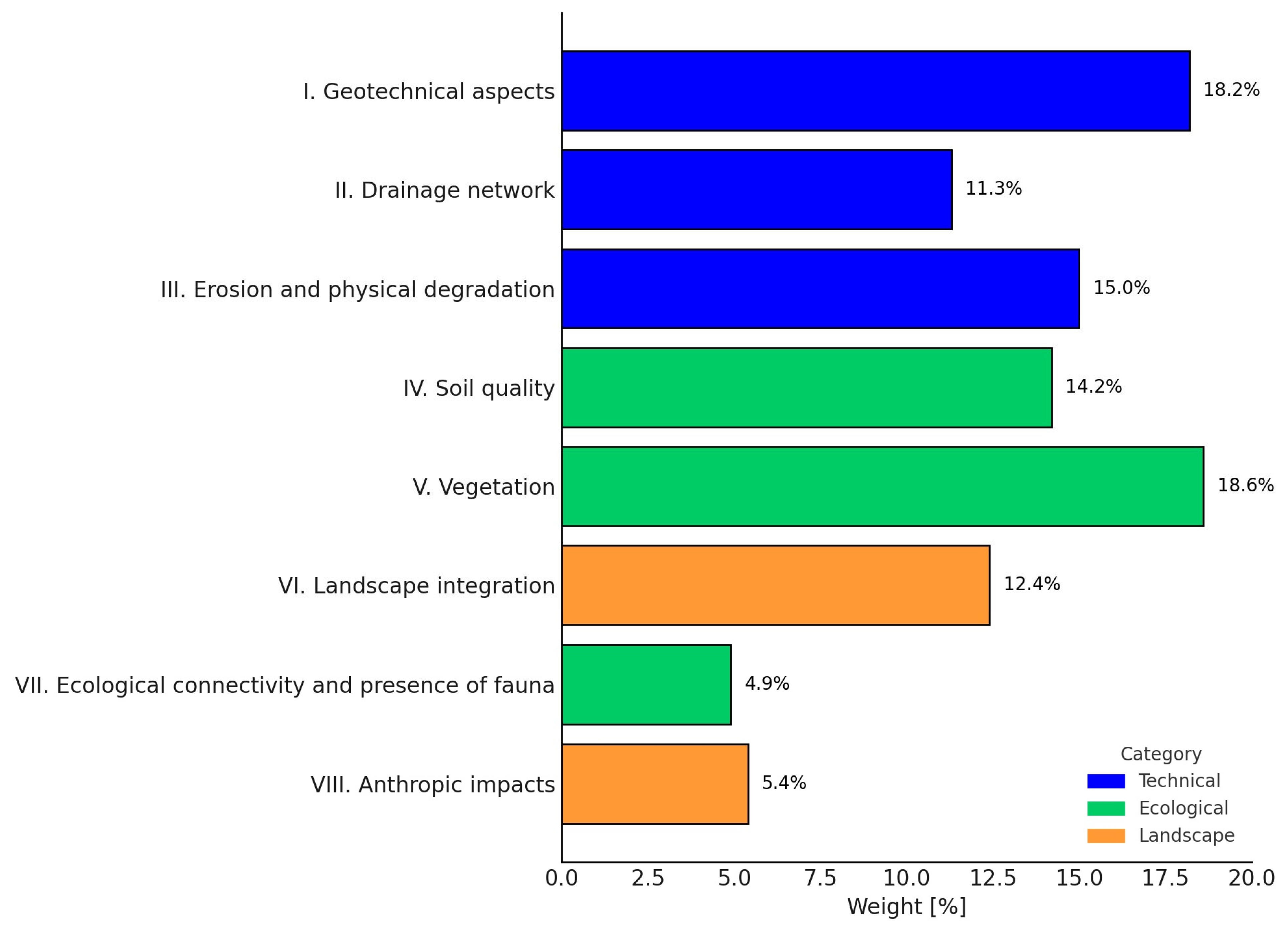
In addition to this detailed breakdown, it is helpful to consider the overall distribution of weights across the eight thematic groups. This visualization highlights the dominant evaluation domains and supports strategic decision making in environmental planning and post-mining land use. To enhance the visual clarity of the Delphi evaluation results,
Figure 2 presents the distribution of group weights derived from expert assessments.
The highest total weights were assigned to Geotechnical aspects (18.2%) and Vegetation (18.6%), underscoring their essential role in maintaining physical stability and supporting biodiversity and ecological succession. This prominence reflects the dual priority of ensuring safety and restoring ecological functionality.
Significant importance was also given to Erosion and physical degradation (15.0%) and Soil quality (14.2%), as these directly affect the establishment of vegetation and the integrity of the soil profile. In contrast, Ecological connectivity and presence of fauna (4.9%) received the lowest total weight, primarily due to the inclusion of only a single indicator—the existence of ecological barriers. Despite its low weighting, this parameter plays a vital role in determining long-term landscape functionality.
At the indicator level, “Landslide-affected area” emerged as the most heavily weighted (10.2%), reflecting the critical importance of slope stability and the need for targeted geotechnical interventions to ensure safe reclamation outcomes.
Although groups such as Anthropic impacts (5.4%) and Ecological connectivity received lower overall weights, they offer valuable complementary insights into landscape quality and social–environmental usability, particularly in assessing the long-term success and multifunctionality of reclaimed sites.
3.2.4. Relevance for the Calculation of the RQI
Following the assignment of UI to individual indicators, the next step involves the calculation of the RQI, a composite index designed to provide a quantitative assessment of the overall quality of land reclamation. The RQI serves as a practical tool for comparing restoration strategies, identifying critical deficiencies, and supporting evidence-based decision making in post-mining landscape management.
The calculation of the RQI is based on a combination of two variables: UI, which represent the relative importance of individual indicators, and RQU, which expresses the current state of each reclamation indicator based on field evaluation. The resulting index is calculated using the following formula:
where
;
—weighting coefficient for the i-th parameter;
—reclamation quality unit for the i-th parameter;
n—total number of parameters.
To ensure a meaningful interpretation of results, threshold values were defined. Indicators with RQU < 0.5 should be treated as warning signals, indicating the need for attention or remedial measures. A critical condition arises when RQU = 0, warranting immediate corrective action regardless of the associated weight.
The model also accounts for the potential risk of compensatory masking, where high scores in some indicators may obscure deficiencies in others. Therefore, it is essential to analyze disaggregated results by thematic groups and individual indicators in parallel with the overall RQI value. This approach ensures that the index remains a robust decision-support tool rather than a purely numerical outcome.
The evaluation framework enhances the practical usability of RQI in several key areas:
planning targeted interventions;
optimizing resource allocation;
and supporting long-term monitoring of reclamation performance.
Its methodological advantages lie not only in scientific rigor but also in flexibility, enabling adjustments to local site conditions and land use contexts.
Owing to its systematic structure, validated methodology, and weighted composite formulation, the RQI is suitable for use beyond academic analyses. It provides a functional basis for the following:
comparing different reclamation strategies (e.g., biological vs. technical);
monitoring long-term trends in environmental quality;
and integrating evaluation results into spatial planning processes in post-mining regions.
Moreover, the RQI may serve as a tool for climate adaptation, particularly in the face of increasing environmental stressors such as extreme weather events, soil degradation, and biodiversity loss. In this broader perspective, the index contributes to the promotion of sustainable landscape development.
The computational model has been successfully tested in pilot applications, confirming its capacity to sensitively differentiate between varying restoration strategies and to accurately reflect site-specific conditions. These findings affirm the model’s practical relevance and readiness for implementation in environmental management systems.
Due to its universality and adaptability, the RQI methodology is applicable across different geological and geographical settings, making it a promising instrument for broader deployment in post-extraction land restoration and ecological quality assessment.
3.3. Verification of the RQI Model Through Statistical Comparison of Reclamation Types
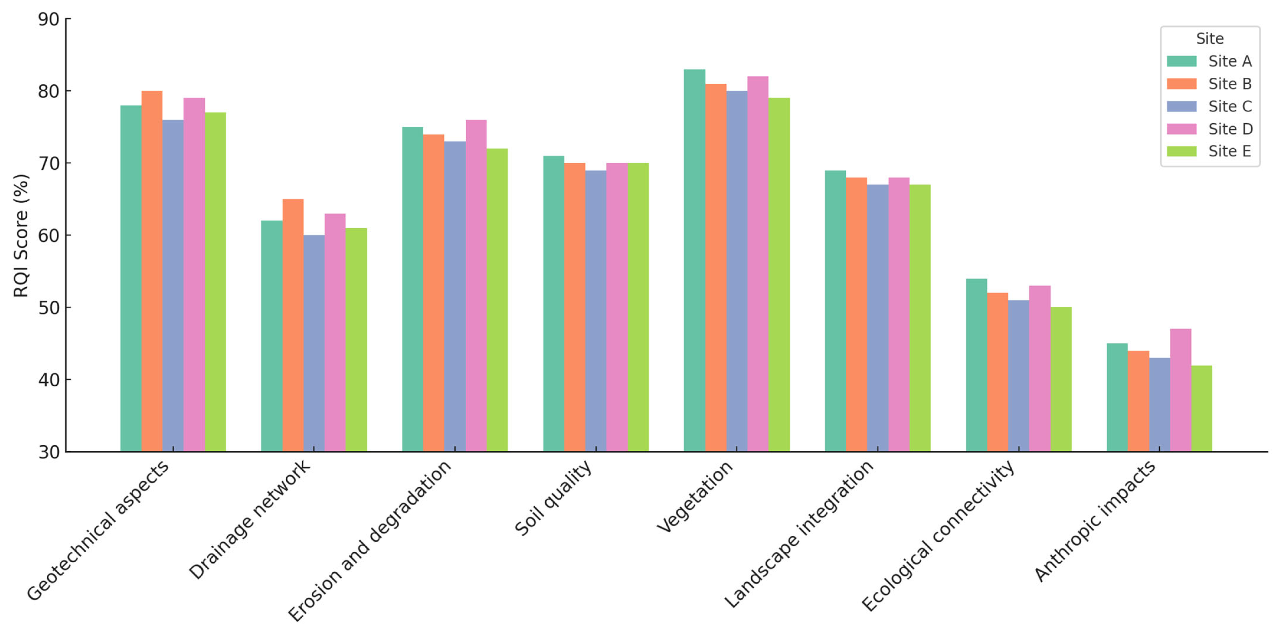
To illustrate the practical utility and spatial differentiation potential of the RQI methodology, a comparative visualization of RQI scores across five post-mining quarry sites is presented (
Figure 3). These quarry sites (hereafter referred to as “quarries” or “sites”) were selected not only to represent distinct reclamation strategies but also to reflect various stages of post-mining land restoration, ranging from early succession to advanced ecological and technical integration.
All selected sites are located in Slovakia and encompass a wide spectrum of reclamation approaches—from passive natural succession to integrated technical and ecological rehabilitation. They also represent a diversity of environmental and geotechnical conditions typically encountered in post-extraction landscapes.
Each bar in
Figure 3 displays the total RQI score for a given site, disaggregated by thematic indicator groups and expressed as weighted percentage contributions. This visual breakdown highlights differences in restoration strategies and reveals specific strengths or deficiencies. For instance, Site B exhibited a markedly low contribution from vegetation indicators, suggesting limited ecological succession, while Site A demonstrated balanced performance across all thematic categories, particularly in vegetation and soil parameters.
A comparison by reclamation type revealed notable differences in overall RQI outcomes. As shown in
Table 6, Sites A and E—both employing combined technical and ecological approaches—achieved the highest RQI scores (0.74 and 0.72, respectively), indicating strong ecological functioning alongside geotechnical stability. In contrast, Site C, where passive natural succession was the primary strategy, attained the lowest score (0.61), primarily due to sparse vegetation cover and underdeveloped soil structure. Site B, which followed a predominantly technical trajectory, reached a moderate score of 0.65, reflecting robust structural integrity but poor ecological integration. Site D, characterized by a largely technical yet more balanced approach, achieved an intermediate score of 0.69.
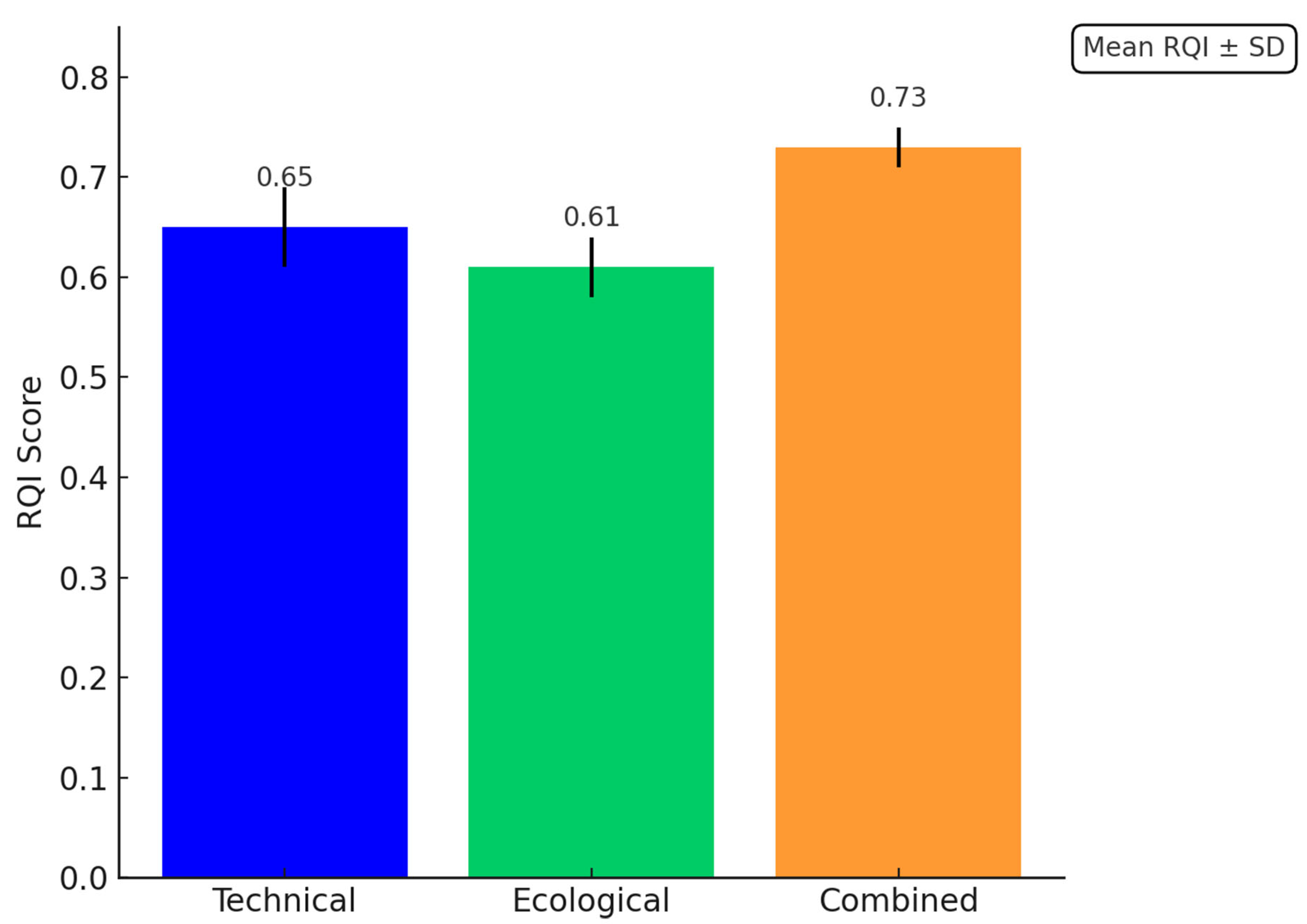
Table 7 presents a statistical summary of RQI scores categorized by dominant reclamation type. The combined approach exhibited the highest mean score (0.73) along with the lowest standard deviation (SD = 0.01), indicating not only superior performance but also high consistency across evaluated sites. In comparison, the technical approach showed a lower average score and higher variability (mean = 0.65, SD = 0.04), suggesting less uniform outcomes. The ecological approach, represented by a single site, recorded the lowest score (0.61), limiting the ability to assess variability within this category.
Figure 4 visually illustrates these differences, highlighting the superior consistency and overall performance of integrated approaches.
These findings confirm the practical relevance and diagnostic precision of the RQI methodology. Its disaggregated structure enables stakeholders to pinpoint specific weaknesses within thematic indicator groups, facilitating more targeted and effective interventions. Unlike conventional aggregate indices, the RQI offers a transparent and adaptable framework for assessing reclamation quality in a structured and comparative manner.
Although the present analysis focused on quarry sites in Slovakia, the model is designed to be transferable across diverse geographic and geological contexts. Its application supports evidence-based planning, fosters sustainable land restoration practices, and informs decision making in post-mining environmental management and policy implementation.
5. Conclusions
The RQI provides a quantifiable framework for evaluating reclamation quality in mining-disturbed landscapes. Unlike previous approaches that focused on isolated ecological or technical parameters, the RQI integrates geotechnical stability, pedologic properties, vegetation cover, landscape esthetic attributes, and anthropogenic influences into a single methodology with high practical applicability.
RQI prioritizes transparency and interdisciplinary consensus: expert panels using the Delphi method assign weights to each indicator, converting qualitative judgments into RQUs and thus objectifying the overall evaluation. In cases where an indicator is rated zero, RQI provides a reliable basis for targeted, timely management interventions.
Building on this structured evaluation, RQI supports permitting, monitoring reclamation progress, and comparing restoration strategies (natural succession vs. technical rehabilitation). Its modular design adapts to diverse Central European landscapes and legacy environmental burdens.
While the expert panel composition and methodological simplifications may influence results, RQI is extensible: future work can integrate climate-adaptation indicators, GIS-based spatial data, and tests on other disturbed sites (landfills, dumps, abandoned mines).
As the EU advances sustainability, biodiversity, and circular-economy goals, RQI delivers a standardized, evidence-based blueprint for planning and implementing long-term landscape restoration.
Implementing RQI at scale will enable decision makers to track and improve reclamation outcomes in real time, fostering adaptive management and continuous ecosystem recovery.


